
Comparative Analysis of Satellite-Based Rainfall Products for Drought Assessment in a Data-Poor Region


Abstract
1. Introduction
2. Materials and Methods
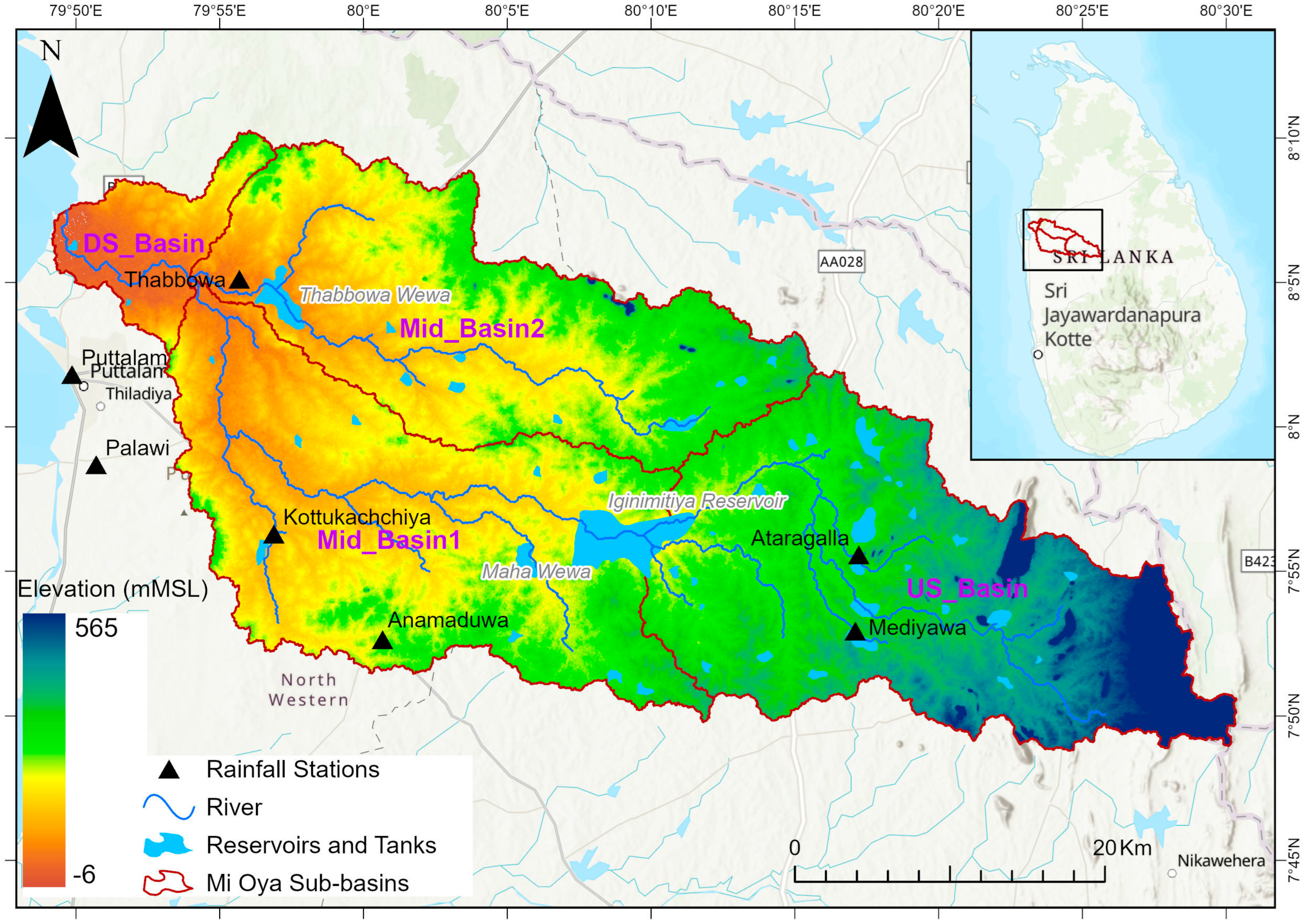
2.1. Study Area
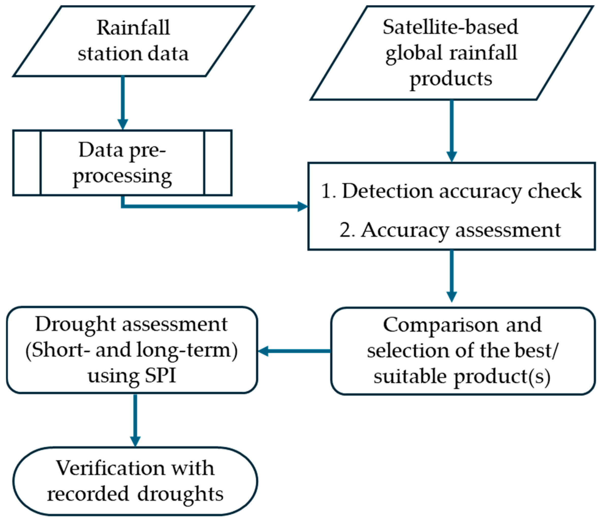
2.2. Methodology
2.2.1. Data and Analysis
- (a)
- Gauge Data
- (b)
- Satellite-based Rainfall Products
2.2.2. Accuracy Assessment of Satellite-Based Data
2.2.3. Drought Analysis
3. Results
3.1. Performance of Satellite Data
3.1.1. Detection of Daily Rainfall
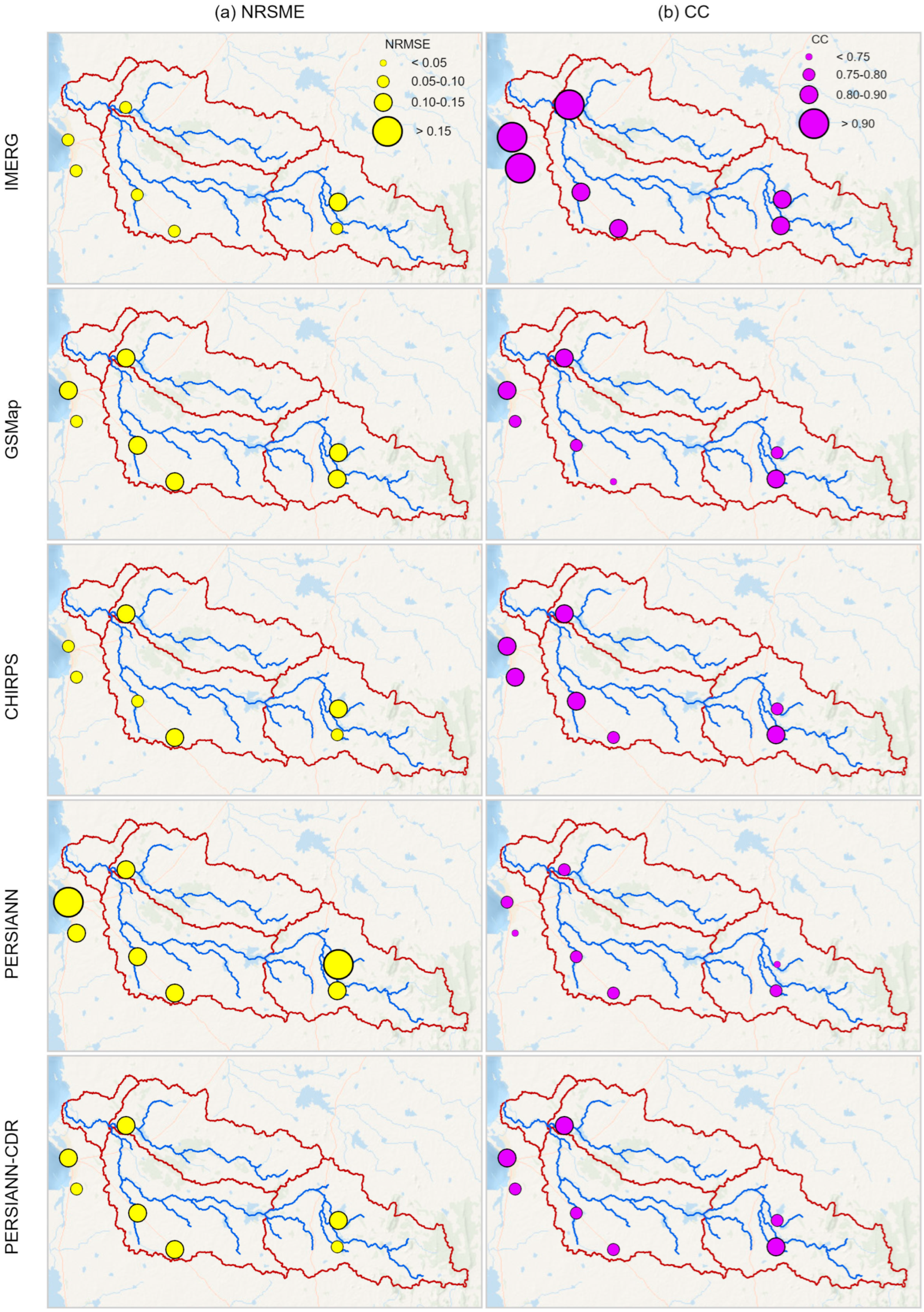
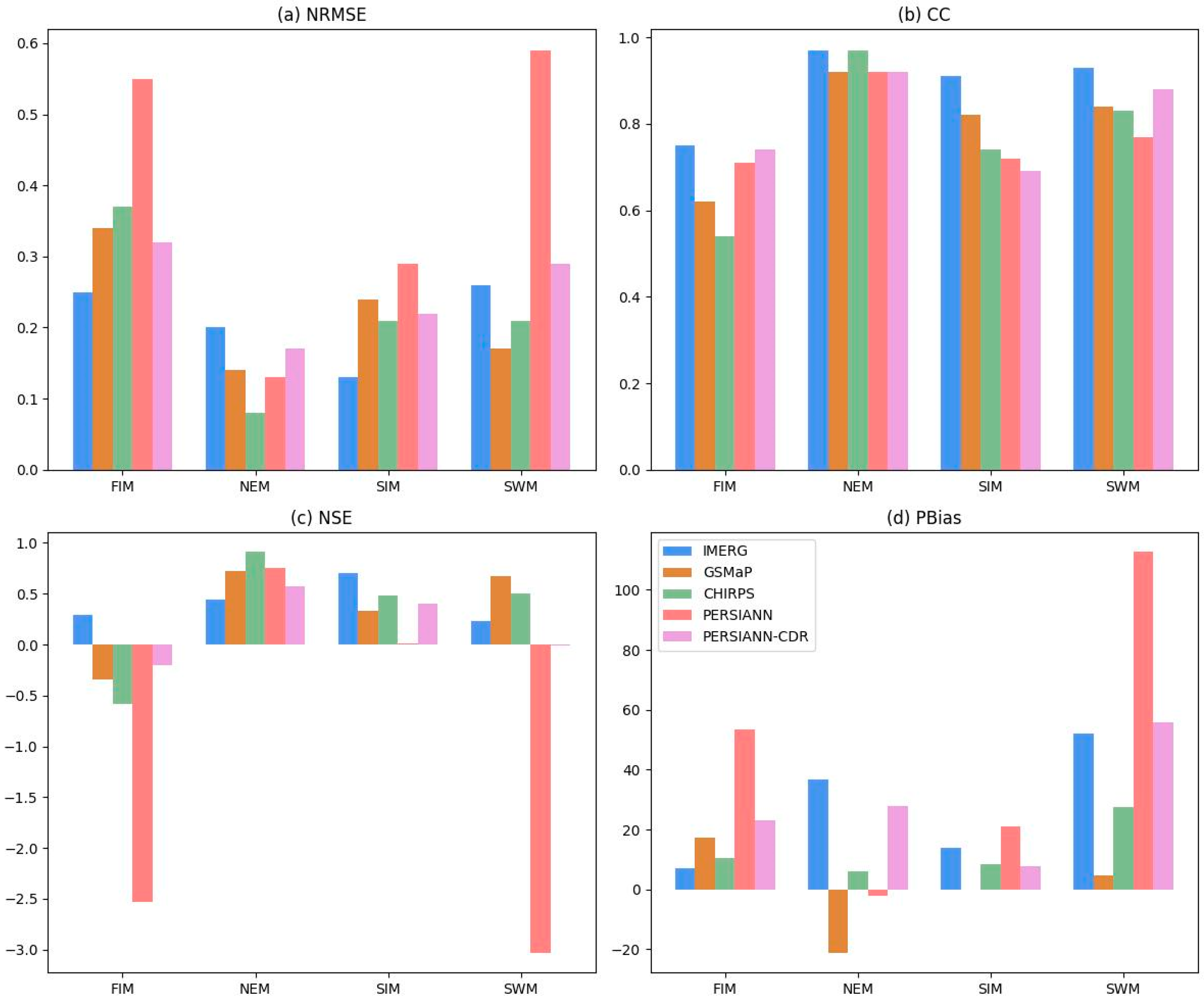
3.1.2. Overall Accuracy
Monthly Scale
Seasonal Scale
Annual Scale
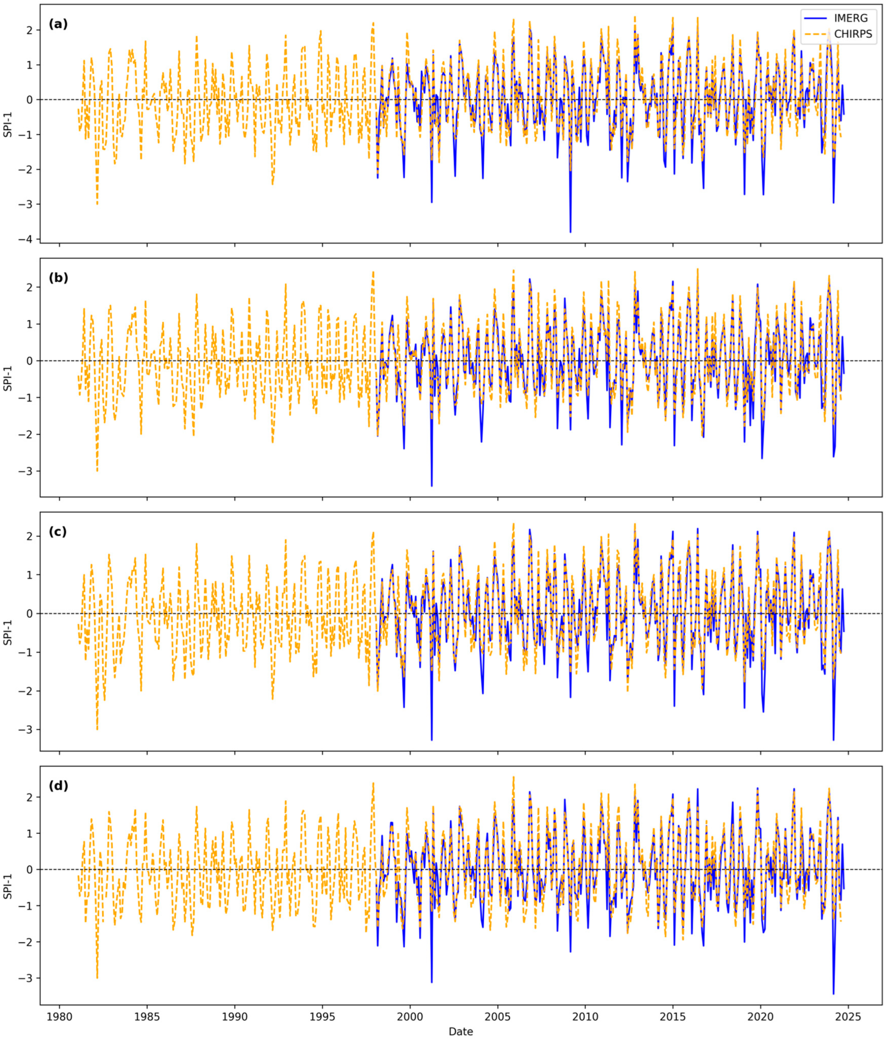
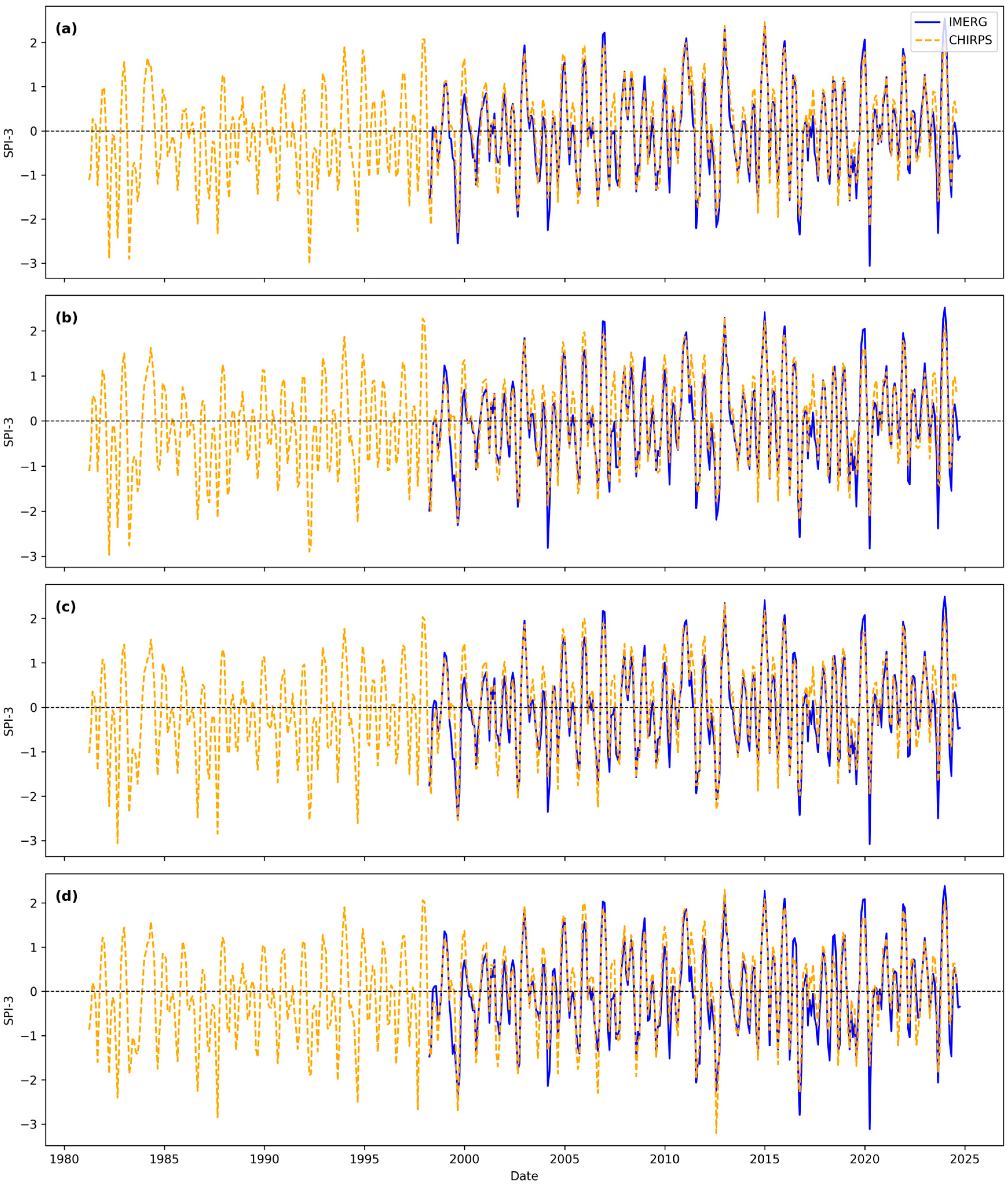
3.2. Drought Assessment over the Mi-Oya Basin
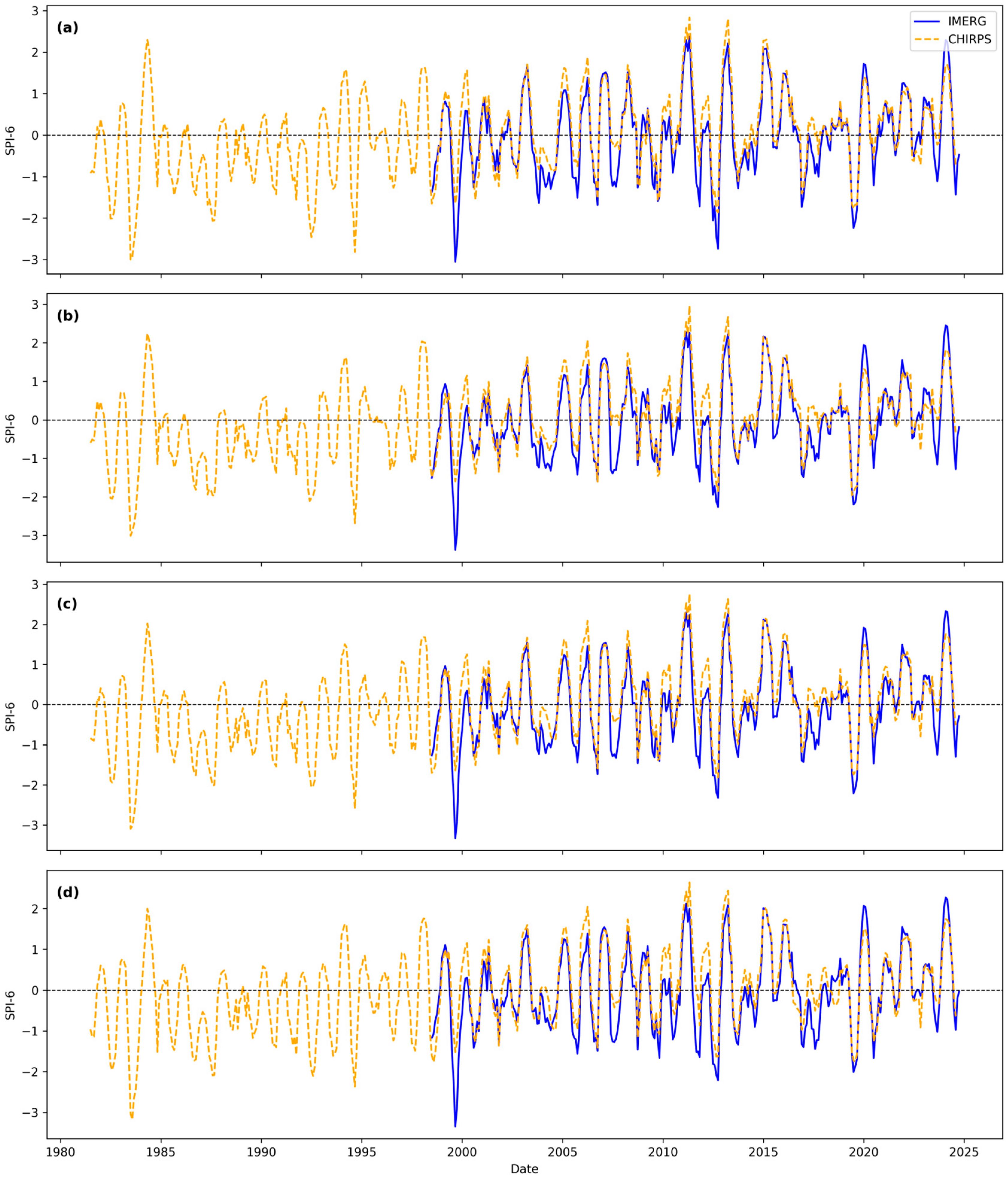
3.2.1. Short-Term Droughts
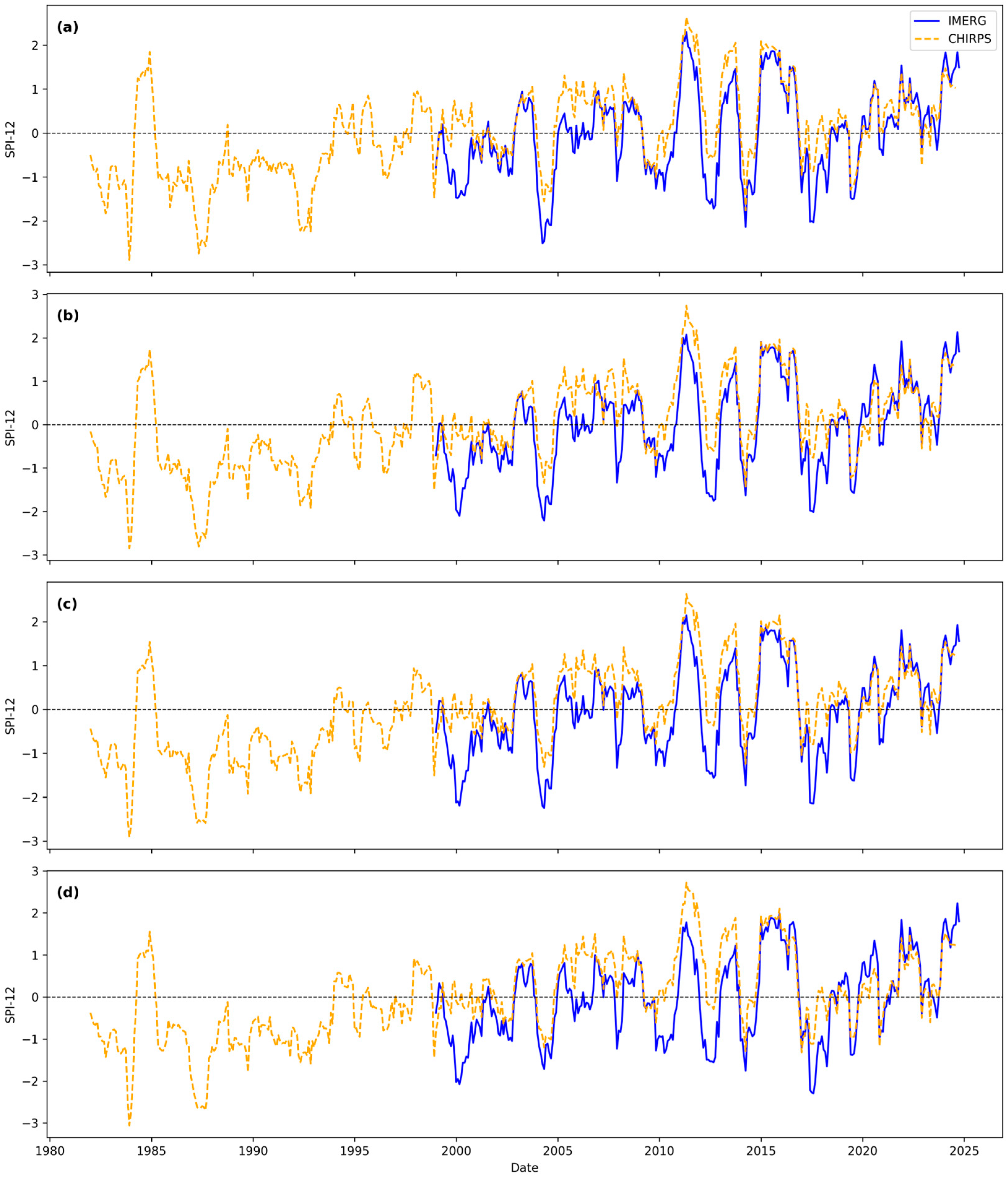
3.2.2. Long-Term Droughts
4. Discussion
4.1. Performance of the Satellite-Based Rainfall
4.2. Suitability of Satellite-Based Rainfall Products in Drought Assessment
5. Conclusions
Author Contributions
Funding
Data Availability Statement
Conflicts of Interest
Appendix A

| Correlation Coefficient (CC) | Interpretation | |
|---|---|---|
| +1 | −1 | Perfect |
| +0.9 to +0.7 | −0.9 to −0.7 | Very strong |
| +0.6 to +0.4 | −0.6 to −0.4 | Strong |
| +0.3 | −0.3 | Moderate |
| +0.2 | −0.2 | Weak |
| +0.1 | −0.1 | Negligible |
| Drought Category | SPI |
|---|---|
| Extremely wet | >2 |
| Very wet | 1.5 to 2 |
| Moderately wet | 1 to 1.5 |
| Near Normal | −1.0 to 1.0 |
| Moderately dry | −1 to −1.5 |
| Severely dry | −1.5 to −2.0 |
| Extremely dry | ≤−2 |
| Station | IMERG | GSMaP | CHIRPS | PERSIANN | PERSIANN -CDR |
|---|---|---|---|---|---|
| NRMSE | |||||
| Anamaduwa | 0.09 | 0.13 | 0.11 | 0.14 | 0.12 |
| Ataragalla | 0.13 | 0.14 | 0.13 | 0.20 | 0.14 |
| Kottukachchiya | 0.09 | 0.11 | 0.10 | 0.14 | 0.11 |
| Madiyawa | 0.09 | 0.11 | 0.09 | 0.14 | 0.10 |
| Palawi | 0.09 | 0.09 | 0.08 | 0.13 | 0.09 |
| Puttalam | 0.08 | 0.12 | 0.10 | 0.17 | 0.11 |
| Thabbowa | 0.10 | 0.11 | 0.11 | 0.15 | 0.11 |
| CC | |||||
| Anamaduwa | 0.86 | 0.73 | 0.80 | 0.76 | 0.76 |
| Ataragalla | 0.81 | 0.76 | 0.79 | 0.70 | 0.77 |
| Kottukachchiya | 0.87 | 0.79 | 0.81 | 0.77 | 0.79 |
| Madiyawa | 0.86 | 0.81 | 0.86 | 0.76 | 0.82 |
| Palawi | 0.93 | 0.78 | 0.84 | 0.72 | 0.80 |
| Puttalam | 0.94 | 0.83 | 0.86 | 0.77 | 0.84 |
| Thabbowa | 0.91 | 0.83 | 0.85 | 0.78 | 0.83 |
| NSE | |||||
| Anamaduwa | 0.71 | 0.43 | 0.62 | 0.29 | 0.54 |
| Ataragalla | 0.53 | 0.48 | 0.54 | −0.07 | 0.42 |
| Kottukachchiya | 0.71 | 0.56 | 0.65 | 0.34 | 0.58 |
| Madiyawa | 0.74 | 0.63 | 0.72 | 0.39 | 0.67 |
| Palawi | 0.74 | 0.55 | 0.69 | 0.07 | 0.56 |
| Puttalam | 0.83 | 0.62 | 0.74 | 0.24 | 0.65 |
| Thabbowa | 0.78 | 0.64 | 0.67 | 0.36 | 0.65 |
| PBias | |||||
| Anamaduwa | 18.1 | −2.3 | 8.0 | 37.2 | 18.9 |
| Ataragalla | 43.8 | 13.2 | 30.3 | 70.5 | 49.3 |
| Kottukachchiya | 26.6 | 6.9 | 10.8 | 42.4 | 23.0 |
| Madiyawa | 9.2 | −17.1 | −10.0 | 28.2 | 10.9 |
| Palawi | 40.9 | 7.5 | 13.8 | 55.9 | 34.3 |
| Puttalam | 24.9 | 2.2 | 4.6 | 41.5 | 23.1 |
| Thabbowa | 24.7 | 3.6 | 19.2 | 37.4 | 19.1 |

References
- Dutta, R. Drought Monitoring in the Dry Zone of Myanmar Using MODIS Derived NDVI and Satellite Derived CHIRPS Precipitation Data. Sustain. Agric. Res. 2018, 7, 46. [Google Scholar] [CrossRef]
- Shah, D.; Mishra, V. Drought Onset and Termination in India. J. Geophys. Res. Atmos. 2020, 125, e2020JD032871. [Google Scholar] [CrossRef]
- Bhardwaj, K.; Mishra, V. Drought Detection and Declaration in India. Water Secur. 2021, 14, 100104. [Google Scholar] [CrossRef]
- Wilhite, D.A. Drought as a Natural Hazards Concept and Definition in Wilhite. In Drought: A Global Assessment; Routledge: London, UK, 2000. [Google Scholar]
- Wilhite, D.A.; Glantz, M.H. Understanding: The Drought Phenomenon: The Role of Definitions. Water Int. 1985, 10, 111–120. [Google Scholar] [CrossRef]
- Sheffield, J.; Wood, E.F. Drought: Past Problems and Future Scenarios; Earthscan: London, UK, 2011. [Google Scholar]
- Mishra, A.K.; Singh, V.P. A Review of Drought Concepts. J. Hydrol. 2010, 391, 202–216. [Google Scholar] [CrossRef]
- Zargar, A.; Sadiq, R.; Naser, B.; Khan, F.I. A Review of Drought Indices. Environ. Rev. 2011, 19, 333–349. [Google Scholar] [CrossRef]
- McKee, T.B.; Doesken, N.J.; Kleist, J. Drought Monitoring with Multiple Time Scales. In Proceedings of the 9th Conference on Applied Climatology, Dallas, TX, USA, 15–20 January 1995; pp. 233–236. [Google Scholar]
- McKee, T.B.; Dosken, N.J.; Kleist, J. The Relationship of Drought Frequency and Duration to Time Scales. In Proceedings of the Eighth Conference on Applied Climatology, Anaheim, CA, USA, 17–22 January 1993; pp. 1–6. [Google Scholar]
- Palmer, W.C. Meteorological Drought; US Department of Commerce, Weather Bureau: Silver Spring, MD, USA, 1965; Volume 30. [Google Scholar]
- Vicente-Serrano, S.M.; Beguería, S.; López-Moreno, J.I. A Multiscalar Drought Index Sensitive to Global Warming: The Standardized Precipitation Evapotranspiration Index. J. Clim. 2010, 23, 1696–1718. [Google Scholar] [CrossRef]
- Tuttle, S.E.; Roof, S.R.; Retelle, M.J.; Werner, A.; Gunn, G.E.; Bunting, E.L. Evaluation of Satellite-Derived Estimates of Lake Ice Cover Timing on Linnévatnet, Kapp Linné, Svalbard Using In-Situ Data. Remote Sens. 2022, 14, 1311. [Google Scholar] [CrossRef]
- Sirisena, T.A.J.G. Process Based Modelling of Future Variations in River Flows and Fluvial Sediment Supply to Coasts Due to Climate Change and Human Activities: Data Poor Regions. Ph.D. Thesis, University of Twente, Enschede, The Netherlands, 2020. [Google Scholar]
- Sirisena, T.A.J.G.; Maskey, S.; Ranasinghe, R.; Babel, S. Effects of Different Precipitation Inputs on Streamflow Simulation in the Irrawaddy River Basin, Myanmar. J. Hydrol. Reg. Stud. 2018, 19, 265–278. [Google Scholar] [CrossRef]
- De Zoysa, S.; Sirisena, J.; Perera, H.; Fernando, S.; Gunathilake, M.; Rathnayake, U. Development of Intensity-Duration-Frequency Curves for Sri Lanka Using Satellite-Based Precipitation Products—Understanding Environmental Conditions and Concerns. Case Stud. Chem. Environ. Eng. 2024, 9, 100713. [Google Scholar] [CrossRef]
- Lv, X.; Guo, H.; Tian, Y.; Meng, X.; Bao, A.; De Maeyer, P. Evaluation of GSMaP Version 8 Precipitation Products on an Hourly Timescale over Mainland China. Remote Sens. 2024, 16, 210. [Google Scholar] [CrossRef]
- Perera, H.; Senaratne, N.; Gunathilake, M.B.; Mutill, N.; Rathnayake, U. Appraisal of Satellite Rainfall Products for Malwathu, Deduru, and Kalu River Basins, Sri Lanka. Climate 2022, 10, 156. [Google Scholar] [CrossRef]
- Cavalcante, R.B.L.; da Silva Ferreira, D.B.; Pontes, P.R.M.; Tedeschi, R.G.; da Costa, C.P.W.; de Souza, E.B. Evaluation of Extreme Rainfall Indices from CHIRPS Precipitation Estimates over the Brazilian Amazonia. Atmos. Res. 2020, 238, 104879. [Google Scholar] [CrossRef]
- Ghorbanian, A.; Mohammadzadeh, A.; Jamali, S.; Duan, Z. Performance Evaluation of Six Gridded Precipitation Products throughout Iran Using Ground Observations over the Last Two Decades (2000–2020). Remote Sens. 2022, 14, 3783. [Google Scholar] [CrossRef]
- Gado, T.A.; Zamzam, D.H.; Guo, Y.; Zeidan, B.A. Evaluation of Satellite-Based Rainfall Estimates in the Upper Blue Nile Basin. J. Earth Syst. Sci. 2024, 133, 27. [Google Scholar] [CrossRef]
- Gulakhmadov, M.; Chen, X.; Gulakhmadov, A.; Umar Nadeem, M.; Gulahmadov, N.; Liu, T. Multiscale Evaluation of Gridded Precipitation Datasets across Varied Elevation Zones in Central Asia’s Hilly Region. Remote Sens. 2023, 15, 4990. [Google Scholar] [CrossRef]
- Gharnouki, I.; Aouissi, J.; Benabdallah, S.; Tramblay, Y. Assessing the Variability of Satellite and Reanalysis Rainfall Products over a Semiarid Catchment in Tunisia. Acta Geophys. 2024, 72, 1257–1273. [Google Scholar] [CrossRef]
- Perera, H.; Fernando, S.; Gunathilake, M.B.; Sirisena, T.A.J.G.; Rathnayake, U. Evaluation of Satellite Rainfall Products over the Mahaweli River Basin in Sri Lanka. Adv. Meteorol. 2022, 2022, 1926854. [Google Scholar] [CrossRef]
- Nicholson, S.E.; Klotter, D.A. Assessing the Reliability of Satellite and Reanalysis Estimates of Rainfall in Equatorial Africa. Remote Sens. 2021, 13, 3609. [Google Scholar] [CrossRef]
- Foster, T.; Mieno, T.; Brozović, N. Satellite-Based Monitoring of Irrigation Water Use: Assessing Measurement Errors and Their Implications for Agricultural Water Management Policy. Water Resour. Res. 2020, 56, e2020WR028378. [Google Scholar] [CrossRef]
- Shiferaw, B.; Tesfaye, K.; Kassie, M.; Abate, T.; Prasanna, B.M.; Menkir, A. Managing Vulnerability to Drought and Enhancing Livelihood Resilience in Sub-Saharan Africa: Technological, Institutional and Policy Options. Weather. Clim. Extrem. 2014, 3, 67–79. [Google Scholar] [CrossRef]
- Rahman, G.; Jung, M.-K.; Kim, T.-W.; Kwon, H.-H. Drought Impact, Vulnerability, Risk Assessment, Management and Mitigation under Climate Change: A Comprehensive Review. KSCE J. Civil. Eng. 2025, 29, 100120. [Google Scholar] [CrossRef]
- Wanasinghe, W.M.A.Y.; Gamage, K.H.; Neluwala, N.G.P.B.; Gimhan, P.G.S. Performance of Different Parameterization Configurations of WRF-ARW Model during Heavy Rainfall over Mi Oya River Basin. Eng. J. Inst. Eng. Sri Lanka 2023, 56, 31–41. [Google Scholar] [CrossRef]
- Madumali, G.V.H.M.; Manamperi, M.M.S.B. Impact of Water Scarcity on Agriculture in Mi Oya River Basin. TRIVALENT ත්රිසංයුජ J. Archaeol. Tour. Anthropol. 2020, 1, 80–89. [Google Scholar] [CrossRef]
- Disaster Management Centre. Annual Report 2014; Disaster Management Centre: Colombo, Sri Lanka, 2014. [Google Scholar]
- Food and Agriculture Organization of the United Nations. Sri Lanka’s Food Production Hit by Extreme Drought Followed by Floods. Available online: https://www.fao.org/newsroom/detail/Sri-Lanka-s-food-production-hit-by-extreme-drought-followed-by-floods/en (accessed on 20 June 2025).
- International Federation of Red Cross and Red Crescent. Revised Emergency Appeal Sri Lanka: Drought; International Federation of Red Cross and Red Crescent: Geneva, Switzerland, 2013. [Google Scholar]
- Lu, G.Y.; Wong, D.W. An Adaptive Inverse-Distance Weighting Spatial Interpolation Technique. Comput. Geosci. 2008, 34, 1044–1055. [Google Scholar] [CrossRef]
- Chen, F.-W.; Liu, C.-W. Estimation of the Spatial Rainfall Distribution Using Inverse Distance Weighting (IDW) in the Middle of Taiwan. Paddy Water Environ. 2012, 10, 209–222. [Google Scholar] [CrossRef]
- Sriwongsitanon, N.; Jandang, W.; Williams, J.; Suwawong, T.; Maekan, E.; Savenije, H.H.G. Using Normalised Difference Infrared Index Patterns to Constrain Semi-Distributed Rainfall–Runoff Models in Tropical Nested Catchments. Hydrol. Earth Syst. Sci. 2023, 27, 2149–2171. [Google Scholar] [CrossRef]
- Ahmed, K.; Nawaz, N.; Khan, N.; Rasheed, B.; Baloch, A. Inhomogeneity Detection in the Precipitation Series: Case of Arid Province of Pakistan. Environ. Dev. Sustain. 2021, 23, 7176–7192. [Google Scholar] [CrossRef]
- Khalil, A. Inhomogeneity Detection in the Rainfall Series for the Mae Klong River Basin, Thailand. Appl. Water Sci. 2021, 11, 147. [Google Scholar] [CrossRef]
- Huffman, G.J.; Stocker, E.F.; Bolvin, D.T.; Nelkin, E.J.; Tan, J. GPM IMERG Final Precipitation L3 1 Day 0.1 Degree x 0.1 Degree V07; Goddard Earth Sciences Data and Information Services Center (GES DISC): Greenbelt, MD, USA, 2023. [Google Scholar]
- Li, X.; O, S.; Wang, N.; Liu, L.; Huang, Y. Evaluation of the GPM IMERG V06 Products for Light Rain over Mainland China. Atmos. Res. 2021, 253, 105510. [Google Scholar] [CrossRef]
- Kubota, T.; Aonashi, K.; Ushio, T.; Shige, S.; Takayabu, Y.N.; Kachi, M.; Arai, Y.; Tashima, T.; Masaki, T.; Kawamoto, N.; et al. Global Satellite Mapping of Precipitation (GSMaP) Products in the GPM Era. In Satellite Precipitation Measurement. Advances in Global Change Research; Springer: Cham, Switzerland, 2020; pp. 355–373. [Google Scholar] [CrossRef]
- Nepal, B.; Shrestha, D.; Sharma, S.; Shrestha, M.S.; Aryal, D.; Shrestha, N. Assessment of GPM-Era Satellite Products’ (IMERG and GSMaP) Ability to Detect Precipitation Extremes over Mountainous Country Nepal. Atmosphere 2021, 12, 254. [Google Scholar] [CrossRef]
- Funk, C.; Peterson, P.; Landsfeld, M.; Pedreros, D.; Verdin, J.; Shukla, S.; Husak, G.; Rowland, J.; Harrison, L.; Hoell, A.; et al. The Climate Hazards Infrared Precipitation with Stations—A New Environmental Record for Monitoring Extremes. Sci. Data 2015, 2, 150066. [Google Scholar] [CrossRef]
- Nguyen, P.; Shearer, E.J.; Tran, H.; Ombadi, M.; Hayatbini, N.; Palacios, T.; Huynh, P.; Braithwaite, D.; Updegraff, G.; Hsu, K.; et al. The CHRS Data Portal, an Easily Accessible Public Repository for PERSIANN Global Satellite Precipitation Data. Sci. Data 2019, 6, 180296. [Google Scholar] [CrossRef] [PubMed]
- Sorooshian, S.; Nguyen, P.; Sellars, S.; Braithwaite, D.; AghaKouchak, A.; Hsu, K. Satellite-Based Remote Sensing Estimation of Precipitation for Early Warning Systems. In Extreme Natural Hazards, Disaster Risks and Societal Implications; Cambridge University Press: Cambridge, UK, 2014; pp. 99–112. [Google Scholar]
- Ashouri, H.; Hsu, K.L.; Sorooshian, S.; Braithwaite, D.K.; Knapp, K.R.; Cecil, L.D.; Nelson, B.R.; Prat, O.P. PERSIANN-CDR: Daily Precipitation Climate Data Record from Multisatellite Observations for Hydrological and Climate Studies. Bull. Am. Meteorol. Soc. 2015, 96, 69–83. [Google Scholar] [CrossRef]
- Kumar, S.; Amarnath, G.; Ghosh, S.; Park, E.; Baghel, T.; Wang, J.; Pramanik, M.; Belbase, D. Assessing the Performance of the Satellite-Based Precipitation Products (SPP) in the Data-Sparse Himalayan Terrain. Remote Sens. 2022, 14, 4810. [Google Scholar] [CrossRef]
- Zhang, Y.; Li, Y.; Ji, X.; Luo, X.; Li, X. Evaluation and Hydrologic Validation of Three Satellite-Based Precipitation Products in the Upper Catchment of the Red River Basin, China. Remote Sens. 2018, 10, 1881. [Google Scholar] [CrossRef]
- Zhu, Q.; Luo, Y.; Zhou, D.; Xu, Y.-P.; Wang, G.; Gao, H. Drought Monitoring Utility Using Satellite-Based Precipitation Products over the Xiang River Basin in China. Remote Sens. 2019, 11, 1483. [Google Scholar] [CrossRef]
- Wang, J.; Petersen, W.A.; Wolff, D.B. Validation of Satellite-Based Precipitation Products from TRMM to GPM. Remote Sens. 2021, 13, 1745. [Google Scholar] [CrossRef]
- Wang, X.; Ding, Y.; Zhao, C.; Wang, J. Validation of TRMM 3B42V7 Rainfall Product under Complex Topographic and Climatic Conditions over Hexi Region in the Northwest Arid Region of China. Water 2018, 10, 1006. [Google Scholar] [CrossRef]
- Alahacoon, N.; Edirisinghe, M.; Ranagalage, M. Satellite-Based Meteorological and Agricultural Drought Monitoring for Agricultural Sustainability in Sri Lanka. Sustainability 2021, 13, 3427. [Google Scholar] [CrossRef]
- Jafari, S.M.; Nikoo, M.R.; Dehghani, M.; Alijanian, M. Evaluation of Two Satellite-Based Products against Ground-Based Observation for Drought Analysis in the Southern Part of Iran. Nat. Hazards 2020, 102, 1249–1267. [Google Scholar] [CrossRef]
- Sirisena, J.; Augustijn, D.; Nazeer, A.; Bamunawala, J. Use of Remote-Sensing-Based Global Products for Agricultural Drought Assessment in the Narmada Basin, India. Sustainability 2022, 14, 13050. [Google Scholar] [CrossRef]
- Senatilleke, U.; Sirisena, J.; Gunathilake, M.B.; Muttil, N.; Rathnayake, U. Monitoring the Meteorological and Hydrological Droughts in the Largest River Basin (Mahaweli River) in Sri Lanka. Climate 2023, 11, 57. [Google Scholar] [CrossRef]
- Guttman, N.B. Comparing the Palmer Drought Index and the Standardized Precipitation Index. JAWRA J. Am. Water Resour. Assoc. 1998, 34, 113–121. [Google Scholar] [CrossRef]
- Abeysingha, N.S.; Rajapaksha, U.R.L.N. SPI-Based Spatiotemporal Drought over Sri Lanka. Adv. Meteorol. 2020, 2020, 9753279. [Google Scholar] [CrossRef]
- Yuan, X.; Wood, E.F. Multimodel Seasonal Forecasting of Global Drought Onset. Geophys. Res. Lett. 2013, 40, 4900–4905. [Google Scholar] [CrossRef]
- Ma, F.; Yuan, X.; Ye, A. Seasonal Drought Predictability and Forecast Skill over China. J. Geophys. Res. Atmos. 2015, 120, 8264–8275. [Google Scholar] [CrossRef]
- Arshad, M.; Ma, X.; Yin, J.; Ullah, W.; Ali, G.; Ullah, S.; Liu, M.; Shahzaman, M.; Ullah, I. Evaluation of GPM-IMERG and TRMM-3B42 Precipitation Products over Pakistan. Atmos. Res. 2021, 249, 105341. [Google Scholar] [CrossRef]
- Ghimire, U.; Akhtar, T.; Shrestha, N.K.; Paul, P.K.; Schürz, C.; Srinivasan, R.; Daggupati, P. A Long-Term Global Comparison of IMERG and CFSR with Surface Precipitation Stations. Water Resour. Manag. 2022, 36, 5695–5709. [Google Scholar] [CrossRef]
- Disaster Management Centre. Historical Disaster Information System in Sri Lanka: Preliminary Analysis; Disaster Management Centre: Colombo, Sri Lanka, 2007. [Google Scholar]
- Somasundaram, D.; Zhu, J.; Zhang, Y.; Nie, Y.; Zhang, Z.; Yu, L. Drought Characteristics and Drought-Induced Effects on Vegetation in Sri Lanka. Climate 2024, 12, 172. [Google Scholar] [CrossRef]
- Food and Agriculture Organization. GIEWS—Global Information and Early Warning System on Food and Agriculture: Special Alert No. 269—Sri Lanka—25 July 1996; Food and Agriculture Organization of United Nations: Rome, Italy, 1996. [Google Scholar]
- UNCCD. National Report on Desertification/Land Degradation in Sri Lanka; UNCCD: Bonn, Germany, 2000. [Google Scholar]
| Rain Gauge Station | Location | Annual Rainfall (mm) | Maximum Daily Rainfall (mm) | Daily Mean ± Std (mm) | |
|---|---|---|---|---|---|
| Latitude | Longitude | ||||
| Anamaduwa | 7.878 | 80.011 | 1573 | 354 | 4 ± 15 |
| Ataragalla | 7.927 | 80.287 | 1303 | 219 | 4 ± 13 |
| Kottukachchiya | 7.939 | 79.948 | 1426 | 274 | 4 ± 14 |
| Mediyawa | 7.883 | 80.285 | 1608 | 244 | 4 ± 14 |
| Puttalam | 8.031 | 79.831 | 1319 | 831 | 4 ± 15 |
| Palawi | 7.979 | 79.845 | 1279 | 298 | 4 ± 12 |
| Thabbowa | 8.086 | 79.928 | 1338 | 285 | 4 ± 13 |
| Product | Spatial Resolution | Spatial Coverage | Temporal Resolution | Temporal Coverage |
|---|---|---|---|---|
| IMERG | 0.1° | 90° N–90° S | 30 min/ daily | 1998—NRT |
| GSMaP | 0.1° | 60° N–60° S | hourly | 2003—NRT |
| CHIRPS | 0.05° | 50° N–50° S | Daily | 1981—NRT |
| PERSIANN | 0.25° | 60° N–60° S | Daily * | 2000—NRT |
| PERSIANN-CDR | 0.25° | 60° N–60° S | Daily * | 1983—NRT |
| Satellite Data | Gauge Observation | |
|---|---|---|
| Rain | No-Rain | |
| Rain | H- Hit | F = False Detection |
| No rain | M- Miss | Correct No Rain |
| Station | IMERG | GSMaP | CHIRPS | PERSIANN | PERSIANN CDR | ||||||||||
|---|---|---|---|---|---|---|---|---|---|---|---|---|---|---|---|
| POD | FAR | CSI | POD | FAR | CSI | POD | FAR | CSI | POD | FAR | CSI | POD | FAR | CSI | |
| For Light Rainfall | |||||||||||||||
| Anamaduwa | 0.83 | 0.78 | 0.21 | 0.56 | 0.66 | 0.27 | 0.57 | 0.69 | 0.25 | 0.60 | 0.73 | 0.23 | 0.85 | 0.77 | 0.22 |
| Ataragalla | 0.75 | 0.90 | 0.10 | 0.67 | 0.80 | 0.18 | 0.61 | 0.83 | 0.16 | 0.65 | 0.85 | 0.14 | 0.83 | 0.89 | 0.11 |
| Kottukachchiya | 0.78 | 0.85 | 0.15 | 0.60 | 0.74 | 0.22 | 0.57 | 0.77 | 0.20 | 0.58 | 0.81 | 0.17 | 0.85 | 0.83 | 0.16 |
| Madiyawa | 0.81 | 0.79 | 0.20 | 0.64 | 0.66 | 0.29 | 0.57 | 0.71 | 0.24 | 0.60 | 0.75 | 0.22 | 0.85 | 0.79 | 0.21 |
| Palawi | 0.81 | 0.74 | 0.24 | 0.57 | 0.55 | 0.34 | 0.56 | 0.61 | 0.30 | 0.59 | 0.67 | 0.27 | 0.86 | 0.72 | 0.27 |
| Puttalam | 0.83 | 0.68 | 0.30 | 0.59 | 0.46 | 0.39 | 0.55 | 0.53 | 0.34 | 0.58 | 0.59 | 0.31 | 0.84 | 0.66 | 0.32 |
| Thabbowa | 0.83 | 0.78 | 0.21 | 0.62 | 0.62 | 0.31 | 0.57 | 0.67 | 0.26 | 0.60 | 0.72 | 0.24 | 0.85 | 0.77 | 0.22 |
| For Moderate Rainfall | |||||||||||||||
| Anamaduwa | 0.39 | 0.62 | 0.24 | 0.29 | 0.69 | 0.18 | 0.20 | 0.69 | 0.14 | 0.35 | 0.76 | 0.17 | 0.15 | 0.70 | 0.11 |
| Ataragalla | 0.38 | 0.70 | 0.20 | 0.30 | 0.68 | 0.18 | 0.19 | 0.76 | 0.12 | 0.40 | 0.76 | 0.18 | 0.15 | 0.78 | 0.10 |
| Kottukachchiya | 0.38 | 0.66 | 0.22 | 0.33 | 0.67 | 0.20 | 0.17 | 0.74 | 0.12 | 0.37 | 0.75 | 0.18 | 0.15 | 0.68 | 0.11 |
| Madiyawa | 0.36 | 0.64 | 0.22 | 0.29 | 0.58 | 0.21 | 0.16 | 0.67 | 0.12 | 0.34 | 0.74 | 0.17 | 0.16 | 0.67 | 0.12 |
| Palawi | 0.43 | 0.68 | 0.22 | 0.27 | 0.73 | 0.15 | 0.20 | 0.70 | 0.14 | 0.37 | 0.77 | 0.16 | 0.15 | 0.72 | 0.11 |
| Puttalam | 0.41 | 0.62 | 0.25 | 0.31 | 0.67 | 0.19 | 0.23 | 0.62 | 0.17 | 0.37 | 0.75 | 0.17 | 0.14 | 0.70 | 0.11 |
| Thabbowa | 0.41 | 0.60 | 0.25 | 0.32 | 0.66 | 0.20 | 0.26 | 0.66 | 0.17 | 0.35 | 0.75 | 0.17 | 0.14 | 0.69 | 0.11 |
| For Heavy Rainfall | |||||||||||||||
| Anamaduwa | 0.20 | 0.71 | 0.13 | 0.09 | 0.91 | 0.05 | 0 | N/A | 0 | 0.09 | 0.80 | 0.07 | 0 | N/A | 0 |
| Ataragalla | 0.06 | 0.75 | 0.05 | 0.00 | 1.00 | 0.00 | 0 | N/A | 0 | 0.06 | 0.80 | 0.05 | 0 | N/A | 0 |
| Kottukachchiya | 0.19 | 0.75 | 0.12 | 0.06 | 0.92 | 0.03 | 0 | N/A | 0 | 0.12 | 0.33 | 0.11 | 0 | N/A | 0 |
| Madiyawa | 0.05 | 0.88 | 0.04 | 0.10 | 0.78 | 0.07 | 0 | N/A | 0 | 0.00 | 1.00 | 0.00 | 0 | N/A | 0 |
| Palawi | 0.17 | 0.88 | 0.08 | 0.13 | 0.92 | 0.05 | 0 | N/A | 0 | 0.13 | 0.67 | 0.10 | 0 | N/A | 0 |
| Puttalam | 0.20 | 0.83 | 0.10 | 0.00 | 1.00 | 0.00 | 0 | N/A | 0 | 0.18 | 0.50 | 0.15 | 0 | N/A | 0 |
| Thabbowa | 0.38 | 0.73 | 0.19 | 0.20 | 0.85 | 0.10 | 0 | N/A | 0 | 0.20 | 0.50 | 0.17 | 0 | N/A | 0 |
| Rainfall Product | NRMSE | CC | NSE | PBIAS (%) |
|---|---|---|---|---|
| IMERG | 0.20 | 0.92 | 0.22 | 17.70 |
| GSMaP | 0.12 | 0.89 | 0.74 | −0.04 |
| CHIRPS | 0.15 | 0.78 | 0.48 | 7.28 |
| PERSIANN | 0.49 | 0.58 | −3.27 | 44.18 |
| PERSIANN-CDR | 0.24 | 0.77 | −0.22 | 19.13 |
Disclaimer/Publisher’s Note: The statements, opinions and data contained in all publications are solely those of the individual author(s) and contributor(s) and not of MDPI and/or the editor(s). MDPI and/or the editor(s) disclaim responsibility for any injury to people or property resulting from any ideas, methods, instructions or products referred to in the content. |
© 2025 by the authors. Licensee MDPI, Basel, Switzerland. This article is an open access article distributed under the terms and conditions of the Creative Commons Attribution (CC BY) license (https://creativecommons.org/licenses/by/4.0/).
Share and Cite
Gayanthika, H.; Lakshitha, D.; Chathuranga, M.; De Silva, G.; Sirisena, J. Comparative Analysis of Satellite-Based Rainfall Products for Drought Assessment in a Data-Poor Region. Hydrology 2025, 12, 166. https://doi.org/10.3390/hydrology12070166
Gayanthika H, Lakshitha D, Chathuranga M, De Silva G, Sirisena J. Comparative Analysis of Satellite-Based Rainfall Products for Drought Assessment in a Data-Poor Region. Hydrology. 2025; 12(7):166. https://doi.org/10.3390/hydrology12070166
Chicago/Turabian StyleGayanthika, Hansini, Dimuthu Lakshitha, Manthika Chathuranga, Gouri De Silva, and Jeewanthi Sirisena. 2025. "Comparative Analysis of Satellite-Based Rainfall Products for Drought Assessment in a Data-Poor Region" Hydrology 12, no. 7: 166. https://doi.org/10.3390/hydrology12070166
APA StyleGayanthika, H., Lakshitha, D., Chathuranga, M., De Silva, G., & Sirisena, J. (2025). Comparative Analysis of Satellite-Based Rainfall Products for Drought Assessment in a Data-Poor Region. Hydrology, 12(7), 166. https://doi.org/10.3390/hydrology12070166