The Effect of Urbanization on the Groundwater Availability in the Masingini–Mwanyanya Catchment Forest, Unguja Island, Zanzibar (Tanzania)
Abstract
1. Introduction
- (i)
- Determine the extent to which urbanization has affected the Masingini–Mwanyanya water catchment forest reserve;
- (ii)
- Analyze the relationship between urbanization (built-up area) and population growth in the Masingini–Mwanyanya water catchment forest reserve;
- (iii)
- Assess the reduction in infiltration and recharge of the aquifer in the forest reserve.
2. Study Area
2.1. Geographical Framework
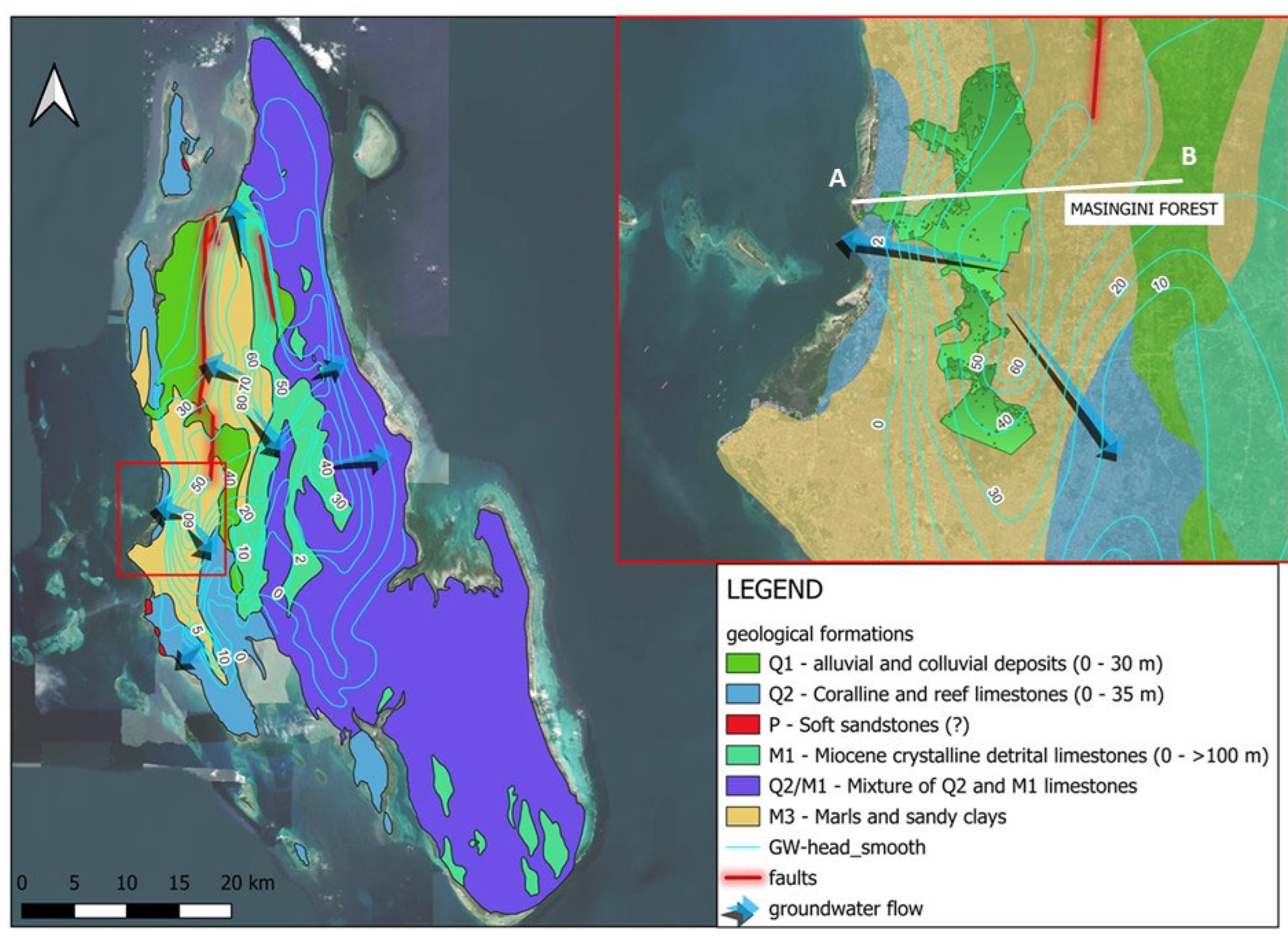
2.2. Geological and Hydrogeological Framework
- Lower Miocene formations—conglomerates, sandstones, marls, and muds (deltaic/fluvial deposits);
- Miocene limestones (grainstones, framestones) deposited in shallow marine reef environments;
- Mesozoic and Paleozoic sediments (Cretaceous, Jurassic, Karoo) comparable to those on the mainland;
- Precambrian crystalline basement [17].
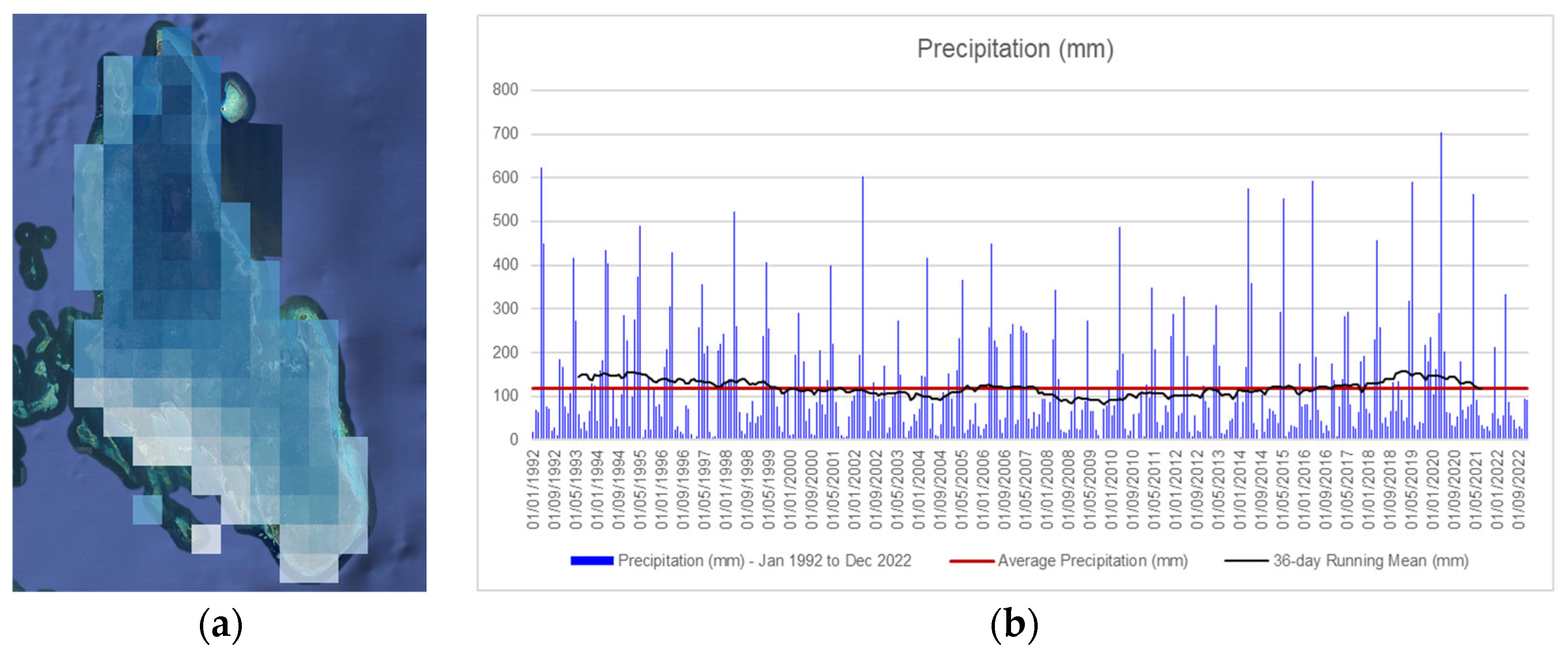
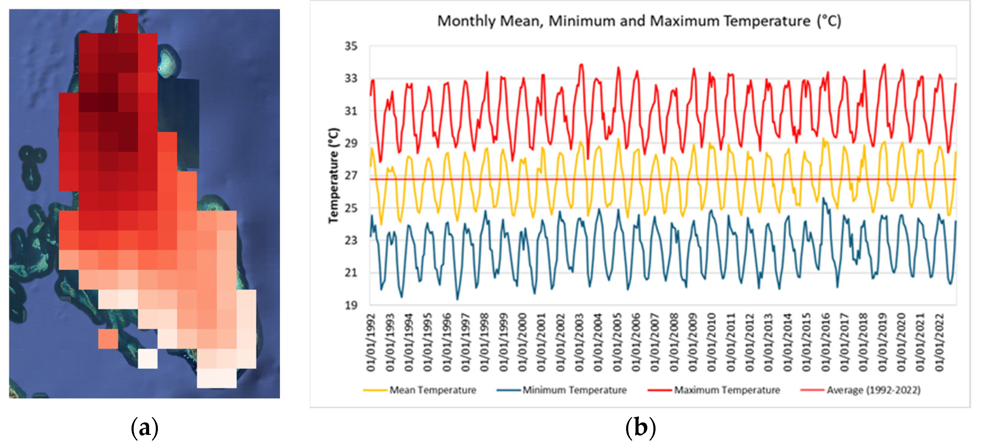
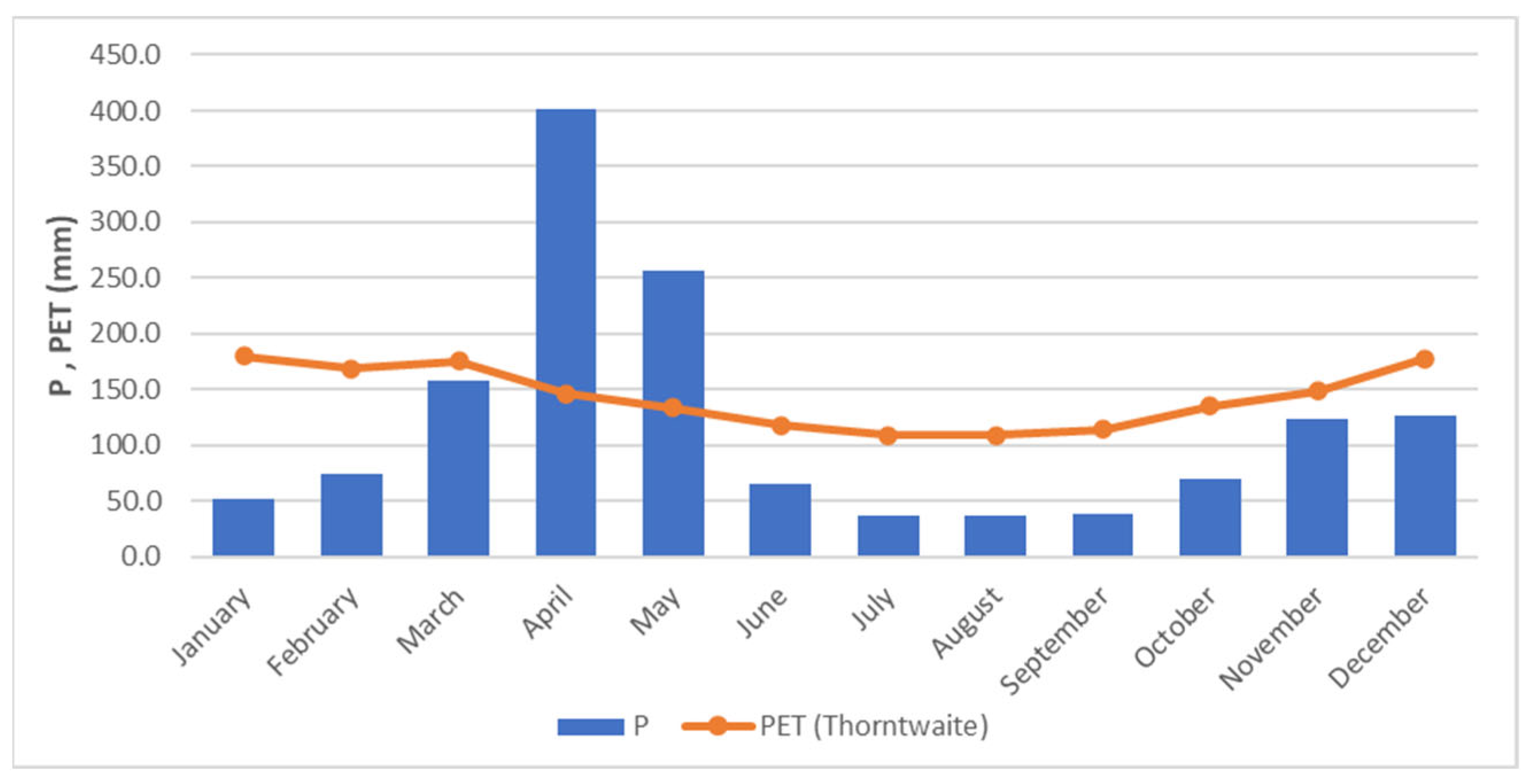
2.3. Climatic Framework
3. Materials and Methods
3.1. Datasets
3.2. RAPS and IPTA Methods for Climate Data Analyses
- -
- Divide the series into possible subperiods where the behavior changes;
- -
- Graphically display the cumulative trend (using the normalized partial sum) and highlight periods where the “accumulated” trend deviates from the expected line.
- -
- Subperiods (e.g., monthly, seasonal) where the trend changes (transitions);
- -
3.3. Land Use/Land Cover (LULC) Classification
3.4. Population Data
- where sign(xj − xk) = 1 if xj − xk > 0
- = 0 if xj − xk = 0
3.5. Hydrogeological Water Balance Method
- Geological map of the study area, geo-referenced from Colbert et al. (1987) [18];
- LULC maps for the years 1992, 2002, 2012, and 2022;
- Average annual temperature (AIT) for the period 1992–2022;
- Average total precipitation (AARM) for the same period.
4. Results and Discussion
4.1. Climate Analyses
- ➢
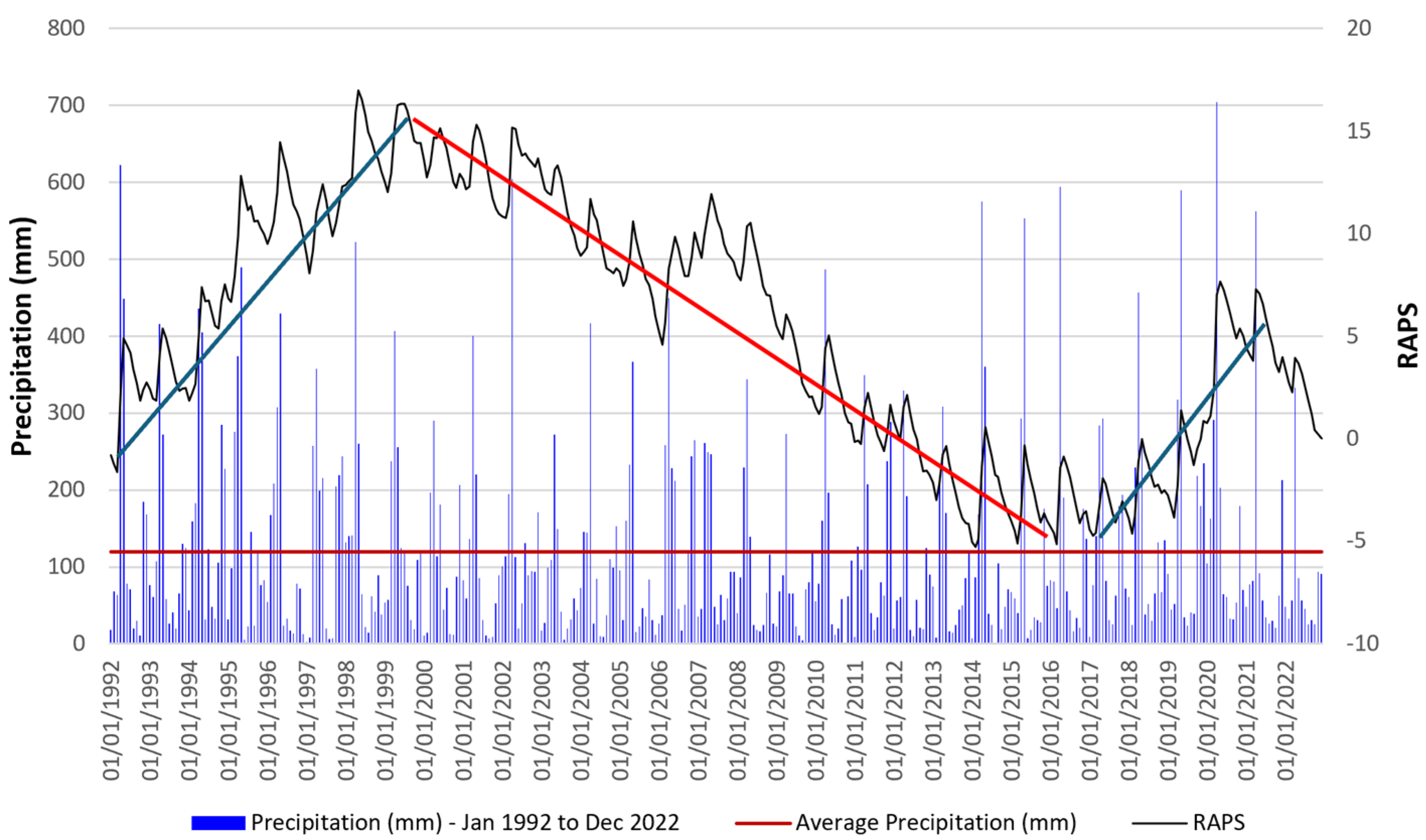
- A first rising trend from 1992 to 1999;
- ➢
- A second decreasing trend from 1999 to 2016;
- ➢
- A third increasing trend from 2016 to 2022.
4.2. LULC Changes in Masingini–Mwanyanya Forest
4.3. LULC Changes in Urban West Area
4.4. Aquifer Recharge Evolution in Time (1992–2022)
5. Conclusions
Author Contributions
Funding
Data Availability Statement
Acknowledgments
Conflicts of Interest
References
- Superfisky, K.; Katz, N. Managing Urban Ecosystems: An Introduction to the Special Issue. Cities Environ. 2023, 16, 1. [Google Scholar]
- Li, W.; Wang, Y.; Xie, S.; Cheng, X. Coupling coordination analysis and spatiotemporal heterogeneity between urbanization and ecosystem health in Chongqing municipality, China. Sci. Total Environ. 2021, 791, 148311. [Google Scholar] [CrossRef] [PubMed]
- Gollin, D.; Jedwab, R.; Vollrath, D. Urbanization with and without industrialization. J. Econ. Growth 2016, 21, 35–70. [Google Scholar] [CrossRef]
- Lall, S.V.; Henderson, J.V.; Venables, A.J. Africa’s Cities: Opening Doors to the World; World Bank Publications: Washington, DC, USA, 2017. [Google Scholar]
- Ryan, C.M.; Pritchard, R.; McNicol, I.; Owen, M.; Fisher, J.A.; Lehmann, C. Ecosystem services from southern African woodlands and their future under global change. Philos. Trans. R. Soc. B Biol. Sci. 2016, 371, 20150312. [Google Scholar] [CrossRef]
- Lwasa, S.; Buyana, K.; Kasaija, P.; Mutyaba, J. Scenarios for adaptation and mitigation in urban Africa under 1.5 °C global warming. Curr. Opin. Environ. Sustain. 2018, 30, 52–58. [Google Scholar] [CrossRef]
- Thorn, J.P.R.; Biancardi-Aleu, R.; Wijesinghe, A.; Mdongwe, M.; Marchant, R.; Shackleton, S. Mainstreaming nature-based solutions for climate resilient infrastructure in peri-urban sub-Saharan Africa. Landsc. Urban Plan. 2021, 216, 104235. [Google Scholar] [CrossRef]
- Kukkonen, M.; Käyhkö, N. Spatio-temporal analysis of forest changes in contrasting land use regimes of Zanzibar, Tanzania. Appl. Geogr. 2014, 55, 193–202. [Google Scholar] [CrossRef]
- Mwampamba, T.H. Forest Recovery and Carbon Sequestration Under Shifting Cultivation in the Eastern Arc Mountains, Tanzania: Landscape and Landuse Effects. Ph.D. Thesis, University of California, Davis, CA, USA, 2009. [Google Scholar]
- NBS. Tanzania in Figures 2022. Available online: https://www.nbs.go.tz/nbs/takwimu/Census2022/Administrative_units_Population_Distribution_Report_Tanzania_volume1a.pdf#page=265.08 (accessed on 20 October 2025).
- The United Republic of Tanzania (URT), Ministry of Finance and Planning; Tanzania National Bureau of Statistics; President’s Office—Finance and Planning; Office of the Chief Government Statistician, Zanzibar. The 2022 Population and Housing Census: Administrative Units Population Distribution Report; Tanzania, 2022; Available online: https://www.nbs.go.tz/nbs/takwimu/Census2022/Administrative_units_Population_Distribution_Report_Tanzania_volume1a.pdf (accessed on 20 October 2025).
- Sappa, G.; Ferranti, F.; De Filippi, F.M. Assessment of vulnerability to seawater intrusion for the coastal aquifer of Dar es Salaam (Tanzania). In Proceedings of the 17th International Multidisciplinary Scientific Geoconference SGEM 2017, Albena, Bulgaria, 29 June–5 July 2017. [Google Scholar]
- De Filippi, F.M.; Giaccio, F.; Ricci, L.; Sappa, G. Modelling artificial infiltration through the vadose zone in the unconfined coastal aquifer of Dar Es Salaam (Tanzania): A preliminary assessment for a managed aquifer recharge (MAR) solution. Environ. Earth Sci. 2025, 84, 552. [Google Scholar] [CrossRef]
- GWP Tanzania. Rapid Assessment of Groundwater Resources in Zanzibar; Global Water Partnership Tanzania: Dar es Salaam, Tanzania, 2023. [Google Scholar]
- World Bank. Boosting Inclusive Growth for Zanzibar (BIG-Z): Environmental and Social Management Framework; World Bank: Washington, DC, USA, 2020. [Google Scholar]
- Shapira & Hellerman Planners; ROM Transportation Engineering Ltd. ZanPlan: Urban Development Report; Zanzibar, Tanzania, 2015. [Google Scholar]
- Mpanda, S. Geological development of the East African Coastal Basin of Tanzania. J. Afr. Earth Sci. 1997, 24, 371–391. [Google Scholar]
- Colbert, G.; Wagner, B.H.; United Nations Department of Conference Services Cartographic Unit. Hydrogeological Map of Zanzibar: Including the Islands of Zanzibar and Pemba, the United Republic of Tanzania [Map]; United Nations: New York, NY, USA, 1987. [Google Scholar]
- Sikat, L.B. Assessing the Spatial and Temporal Characteristics of Groundwater Recharge in Zanzibar: Towards the Optimal Management of Groundwater Resources. Master’s Thesis, University of Twente, Enschede, The Netherlands, 2011. [Google Scholar]
- Abdalla, Y.; Makokha, M.; Maalim, M.K. Effect of Rainfall Variability on Spring Discharge in the Masingini Catchment, Zanzibar-Tanzania. Int. J. Environ. Geoinform. 2021, 8, 39–48. [Google Scholar] [CrossRef]
- Nikos, K.; Shipton, C.; Mills, W.; Tibesasa, R.; Horton, H.; Horton, M.; Prendergast, M.; Crowther, A.; Douka, K.; Faulkner, P.; et al. Late Quaternary speleogenesis and landscape evolution in a tropical carbonate island: Pango la Kuumbi (Kuumbi Cave), Zanzibar. Int. J. Speleol. 2015, 44, 293–314. [Google Scholar] [CrossRef]
- Ali, S. Assessment of the Impacts of Groundwater Pumpage on Water Resources in Zanzibar. Master’s Thesis, Nelson Mandela African Institution of Science and Technology, Arusha, Tanzania, 2020. [Google Scholar]
- Mwevura, H.; Haji, M.R.; Othman, W.J.; Okafor, C.J. Seasonal Assessment of Quality of Groundwater from Private Owned Wells in Unguja Island Zanzibar. Int. J. Trop. Dis. Health 2021, 42, 30–45. [Google Scholar] [CrossRef]
- Kombo, Y. Sustainable Management and Conservation of the Masingini Indigenous Forest in Zanzibar. 2016. Available online: https://www.researchgate.net/publication/302956085 (accessed on 20 October 2025).
- Anthony, O.O.; Ali, S.A.; Hamad, H.S.; Hamad, M.K.; Juma, K.A. Hydrogeochemistry and Health Risks Assessment of Some Groundwaters Suitability for Drinking within the Urban Region of Unguja Island, Zanzibar. Am. J. Water Sci. Eng. 2021, 7, 113–125. [Google Scholar] [CrossRef]
- Said, M.S.; Maliondo, S.M.; Semoka, J.M.; Msanya, B.M. Extent of Seawater Intrusion from Chwaka and Uzi Bays into Jozani Groundwater Forest, Zanzibar, Tanzania. Int. J. Sci. Eng. Res. 2017, 8, 1143–1149. [Google Scholar]
- Mohamed, A.A.J.; Ali, R.M.; Kombo, M. Groundwater Quality Dynamics during Wet and Dry Incidents in Urban West Region of Zanzibar Island. Int. J. Multidiscip. Res. Anal. 2019, 2, 61–69. [Google Scholar]
- Abatzoglou, J.T.; Dobrowski, S.Z.; Parks, S.A.; Hegewisch, K.C. TerraClimate, a high-resolution global dataset of monthly climate and climatic water balance from 1958–2015. Sci. Data 2018, 5, 170191. [Google Scholar] [CrossRef]
- Climate Engine. Desert Research Institute and University of Idaho, Version 2.1. 2025. Available online: http://climateengine.org (accessed on 20 October 2025).
- Huntington, J.; Hegewisch, K.; Daudert, B.; Morton, C.; Abatzoglou, J.; McEvoy, D.; Erickson, T. Climate Engine: Cloud Computing of Climate and Remote Sensing Data for Advanced Natural Resource Monitoring and Process Understanding. Bull. Am. Meteorol. Society 2017, 98, 2397–2410. [Google Scholar] [CrossRef]
- USGS. Earth Explorer. Available online: https://earthexplorer.usgs.gov/ (accessed on 29 July 2025).
- Markovinović, D.; Kranjčić, N.; Đurin, B.; Bjelotomić Oršulić, O. Identifying the Dynamics of the Sea-Level Fluctuations in Croatia Using the RAPS Method. Symmetry 2021, 13, 289. [Google Scholar] [CrossRef]
- Đurin, B.; Raič, M.; Sušilović, P. Application of the RAPS Method of Time Series Analysis to the Assessment of Grout Curtain Performance in Karst—A Case Study of the Hydro Energy Power Plant (HEPP) Mostar Dam in Bosnia and Herzegovina. Hydrology 2022, 9, 192. [Google Scholar] [CrossRef]
- Šrajbek, M.; Đurin, B.; Sušilović, P.; Singh, S.K. Application of the RAPS Method for Determining the Dependence of Nitrate Concentration in Groundwater on the Amount of Precipitation. Earth 2023, 4, 266–277. [Google Scholar] [CrossRef]
- Garbrecht, J.; Fernandez, G.P. Visualization of Trends and Fluctuations in Climatic Records. J. Am. Water Resour. Assoc. 1994, 30, 297–306. [Google Scholar] [CrossRef]
- Đurin, B.; Kranjčić, N.; Kanga, S.; Singh, S.K.; Sakač, N.; Pham, Q.B.; Hunt, J.; Dogančić, D.; Di Nunno, F. Application of Rescaled Adjusted Partial Sums (RAPS) method in hydrology—An overview. Adv. Civ. Archit. Eng. 2022, 13, 58–72. [Google Scholar] [CrossRef]
- Sen, Z.; Sisman, E.; Dabanli, I. Innovative Polygon Trend Analysis (IPTA) and applications. J. Hydrol. 2019, 575, 202–210. [Google Scholar] [CrossRef]
- Achite, M.; Ceribasi, G.; Ceyhunlu, A.I.; Wałęga, A.; Caloiero, T. The innovative polygon trend analysis (IPTA) as a simple qualitative method to detect changes in environment—Example detecting trends of the total monthly precipitation in semiarid area. Sustainability 2021, 13, 12674. [Google Scholar] [CrossRef]
- Alashan, S.; Abu Arra, A.; Şişman, E. Standardized Innovative Polygon Trend Analysis for Climate Change Assessment (S-IPTA). Pure Appl. Geophys. 2024, 181, 2277–2295. [Google Scholar] [CrossRef]
- Acar, E.; Kankal, M.; Akçay, F.; Şan, M. Innovative polygon trend analyses with star graph for rainfall and temperature data in agricultural regions of Turkey. Environ. Earth Sci. 2022, 81, 530. [Google Scholar] [CrossRef]
- Şen, Z. Conceptual monthly trend polygon methodology and climate change assessments. Hydrol. Sci. J. 2021, 66, 503–512. [Google Scholar] [CrossRef]
- Anderson, J.R. A Land Use and Land Cover Classification System for Use with Remote Sensor Data; U.S. Geological Survey Professional Paper; U.S. Geological Survey: Reston, VI, USA, 1976; Volume 964. [Google Scholar]
- Bronstert, A.; Niehoff, D.; Bürger, G. Effects of climate and land-use change on storm runoff generation: Present knowledge and modelling capabilities. Hydrol. Process. 2002, 16, 509–529. [Google Scholar] [CrossRef]
- Käyhkö, N.; Fagerholm, N.; Asseid, B.S.; Mzee, A.J. Dynamic land use and land cover changes and their effect on forest resources in a coastal village of Matemwe, Zanzibar, Tanzania. Land Use Policy 2011, 28, 26–37. [Google Scholar] [CrossRef]
- Kleemann, J.; Inkoom, J.N.; Thiel, M.; Shankar, S.; Lautenbach, S.; Fürst, C. Peri-urban land use pattern and its relation to land use planning in Ghana, West Africa. Landsc. Urban Plan. 2017, 165, 280–294. [Google Scholar] [CrossRef]
- Muhammad, R.; Zhang, W.; Abbas, Z.; Guo, F.; Gwiazdzinski, L. Spatiotemporal change analysis and prediction of future land use and land cover changes using QGIS MOLUSCE plugin and remote sensing big data: A case study of Linyi, China. Land 2022, 11, 419. [Google Scholar] [CrossRef]
- Bolstad, P.; Lillesand, T.M. Rapid maximum likelihood classification. Photogramm. Eng. Remote Sens. 1991, 57, 67–74. [Google Scholar]
- Fichera, C.R.; Modica, G.; Pollino, M. Land cover classification and change-detection analysis using multi-temporal remote sensed imagery and landscape metrics. Eur. J. Remote Sens. 2012, 45, 1–18. [Google Scholar] [CrossRef]
- Foody, G.M. Explaining the unsuitability of the kappa coefficient in the assessment and comparison of the accuracy of thematic maps obtained by image classification. Remote Sens. Environ. 2020, 239, 111630. [Google Scholar] [CrossRef]
- Manandhar, R.; Odeh, I.O.; Ancev, T. Improving the accuracy of land use and land cover classification of Landsat data using post-classification enhancement. Remote Sens. 2009, 1, 330–344. [Google Scholar] [CrossRef]
- Story, M.; Congalton, R.G. Accuracy Assessment: A User’s Perspective. Photogramm. Eng. Remote Sens. 1986, 52, 397–399. [Google Scholar]
- Choudhury, D.; Das, K.; Das, A. Assessment of land use land cover changes and its impact on variations of land surface temperature in Asansol-Durgapur Development Region. Egypt. J. Remote Sens. Space Sci. 2019, 22, 203–218. [Google Scholar] [CrossRef]
- Lu, D.; Batistella, M.; Moran, E.; Mausel, P. Application of spectral mixture analysis to Amazonian land-use and land-cover classification. Int. J. Remote Sens. 2004, 25, 5345–5358. [Google Scholar] [CrossRef]
- Al-Doski, J.; Mansor, S.B.; Shafri, H.Z.M. NDVI differencing and post-classification to detect vegetation changes in Halabja City, Iraq. IOSR J. Appl. Geol. Geophys. 2013, 1, 1–10. [Google Scholar] [CrossRef]
- Hishe, H.; Giday, K.; Van Orshoven, J.; Muys, B.; Taheri, F.; Azadi, H.; Witlox, F. Analysis of land use land cover dynamics and driving factors in Desa’a forest in Northern Ethiopia. Land Use Policy 2021, 101, 105039. [Google Scholar] [CrossRef]
- Serra, P.; Pons, X.; Sauri, D. Post-classification change detection with data from different sensors: Some accuracy considerations. Int. J. Remote Sens. 2003, 24, 3311–3340. [Google Scholar] [CrossRef]
- Shalaby, A.; Tateishi, R. Remote sensing and GIS for mapping and monitoring land cover and land-use changes in the Northwestern coastal zone of Egypt. Appl. Geogr. 2007, 27, 28–41. [Google Scholar] [CrossRef]
- Abdalla, A.H.; Kai, K.H.; Khamis, S.A.; Kondowe, A.L.; Osima, S.E.; King’uza, P.H.; Hamad, A.O. The influence of climate change and variability on spatio-temporal rainfall and temperature distribution in Zanzibar. Atmos. Clim. Sci. 2023, 13, 282–313. [Google Scholar] [CrossRef]
- Potochnik, A.; Colombo, M.; Wright, C. Recipes for Science; Routledge: New York, NY, USA, 2018. [Google Scholar] [CrossRef]
- De Filippi, F.M.; Sappa, G. The Simulation of Bracciano Lake (Central Italy) Levels Based on Hydrogeological Water Budget: A Tool for Lake Water Management when Climate Change and Anthropogenic Impacts Occur. Environ. Process. 2024, 11, 8. [Google Scholar] [CrossRef]
- The United Republic of Tanzania (URT). 2012 Population and Housing Census: Population Distribution by Administrative Areas; URT: Dar es Salaam, Tanzania, 2013. [Google Scholar]
- Mato, R.M. Groundwater quality degradation due to salt water intrusion in Zanzibar Municipality. Afr. J. Environ. Sci. Technol. 2015, 9, 734–740. [Google Scholar] [CrossRef]
- Idowu, T.E.; Lasisi, K.H. Seawater intrusion in the coastal aquifers of East and Horn of Africa: A review from a regional perspective. Sci. Afr. 2020, 8, e00402. [Google Scholar] [CrossRef]
- Pembe-Ali, Z.; Mwamila, T.B.; Lufingo, M.; Gwenzi, W.; Marwa, J.; Rwiza, M.J.; Lugodisha, I.; Qi, Q.; Noubactep, C. Application of the Kilimanjaro Concept in Reversing Seawater Intrusion and Securing Water Supply in Zanzibar, Tanzania. Water 2021, 13, 2085. [Google Scholar] [CrossRef]





| Satellite | Sensor Path/Row | Spatial Resolution (m) | Date of Acquisition | Source | % Cloud Cover |
|---|---|---|---|---|---|
| Landsat 5 | TM 168/070 | 30 | 20 March 1992 | USGS | <10 |
| Landsat 7 | ETM+168/070 | 30 | 22 March 2002 | USGS | <10 |
| Landsat 8 | OLI 168/070 | 30 | 13 March 2012 | USGS | <10 |
| Landsat 8 | OLI 168/070 | 30 | 18 May 2022 | USGS | <10 |
| Accuracy | LULC | 1992 | 2002 | 2012 | 2022 |
|---|---|---|---|---|---|
| Producer’s Accuracy | Built-up | 100 | 96 | 100 | 85 |
| Bare Land | 98 | 94 | 88 | 96 | |
| Forest | 97 | 100 | 97 | 100 | |
| User’s Accuracy | Built-up | 90 | 91 | 100 | 100 |
| Bare Land | 100 | 98 | 96 | 96 | |
| Forest | 98 | 100 | 92 | 94 | |
| Overall Accuracy | 96 | 96.3 | 96 | 96.7 | |
| Kappa Coefficient | 0.94 | 0.91 | 0.91 | 0.92 |
| Geology | χG |
|---|---|
| Q1—Alluvial deposits | 0.3 |
| Q2—Coralline reef limestone | 0.9 |
| P—Soft sandstones | 0.4 |
| M1—Detrital limestone | 0.6 |
| Q2/M1—Mixture of Q2 and M1 | 0.75 |
| M3—Sandy clays | 0.2 |
| Land Cover | χLC |
|---|---|
| Forest | 0.9 |
| Cropland | 0.6 |
| Urban | 0.1 |
| Bare land | 0.8 |
| 1992 | 2002 | 2012 | 2022 | |||||
|---|---|---|---|---|---|---|---|---|
| Area | Area | Area | Area | |||||
| L.C Type | (km2) | % | (km2) | % | (km2) | % | (km2) | % |
| Forest | 8.27 | 72.7 | 8.46 | 74.3 | 5.86 | 51.4 | 7.05 | 62 |
| Buildings | 0.00 | 0.03 | 0.08 | 0.69 | 0.59 | 5.18 | 1.70 | 14.8 |
| Bare land | 3.09 | 27.2 | 2.82 | 24.8 | 4.91 | 43.2 | 2.61 | 22.9 |
| Total Area | 11.36 | 100 | 11.36 | 100 | 11.36 | 100 | 11.36 | 100 |
| Change % b | Annual Rate Change % c | |||||||
|---|---|---|---|---|---|---|---|---|
| 1992–2002 | 2002–2012 | 2012–2022 | 1992–2022 | 1992–2002 | 2002–2012 | 2012–2022 | 1992–2022 | |
| Forest | 1.7 | −22.9 | 10.5 | −10.7 | −0.23 | 3.63 | −1.83 | 1.58 |
| Buildings | 0.7 | 4.5 | 9.8 | 14.9 | −29.58 | −20.01 | −10.51 | −60.09 |
| Bare land | −2.4 | 18.4 | −20.3 | −4.2 | 0.90 | −5.49 | 6.27 | 1.68 |
| 1992 | 2002 | 2012 | 2022 | |||||
|---|---|---|---|---|---|---|---|---|
| LC Type | (km2) | % | (km2) | % | (km2) | % | (km2) | % |
| Forest | 136.4 | 58.6 | 121.7 | 52.3 | 139.6 | 60.0 | 121.7 | 52.3 |
| Cropland | 6.1 | 2.6 | 11.8 | 5.1 | 17.8 | 7.6 | 35.3 | 15.2 |
| Urban | 15.3 | 6.6 | 15.5 | 6.7 | 25.3 | 10.9 | 39.6 | 17.0 |
| Bare land | 74.8 | 32.1 | 83.7 | 36.0 | 49.9 | 21.5 | 36.0 | 15.5 |
| Total Area | 23,264 | 100 | 23264 | 100 | 23264 | 100 | 23264 | 100 |
| Change % | ||||
|---|---|---|---|---|
| 1992–2002 | 2002–2012 | 2012–2022 | 1992–2022 | |
| Forest | −1.07 | 1.47 | −1.28 | −0.36 |
| Cropland | 9.16 | 5.09 | 9.88 | 15.84 |
| Urban | 0.12 | 4.50 | 6.35 | 5.30 |
| Bare land | 1.19 | −4.03 | −2.78 | −1.72 |
Disclaimer/Publisher’s Note: The statements, opinions and data contained in all publications are solely those of the individual author(s) and contributor(s) and not of MDPI and/or the editor(s). MDPI and/or the editor(s) disclaim responsibility for any injury to people or property resulting from any ideas, methods, instructions or products referred to in the content. |
© 2025 by the authors. Licensee MDPI, Basel, Switzerland. This article is an open access article distributed under the terms and conditions of the Creative Commons Attribution (CC BY) license (https://creativecommons.org/licenses/by/4.0/).
Share and Cite
Bakari, S.S.; Kyonda, S.M.; Kai, K.H.; Giaccio, F.; Sappa, G.; De Filippi, F.M. The Effect of Urbanization on the Groundwater Availability in the Masingini–Mwanyanya Catchment Forest, Unguja Island, Zanzibar (Tanzania). Hydrology 2025, 12, 295. https://doi.org/10.3390/hydrology12110295
Bakari SS, Kyonda SM, Kai KH, Giaccio F, Sappa G, De Filippi FM. The Effect of Urbanization on the Groundwater Availability in the Masingini–Mwanyanya Catchment Forest, Unguja Island, Zanzibar (Tanzania). Hydrology. 2025; 12(11):295. https://doi.org/10.3390/hydrology12110295
Chicago/Turabian StyleBakari, Said Suleiman, Suleyman Majaliwa Kyonda, Kombo Hamad Kai, Federica Giaccio, Giuseppe Sappa, and Francesco Maria De Filippi. 2025. "The Effect of Urbanization on the Groundwater Availability in the Masingini–Mwanyanya Catchment Forest, Unguja Island, Zanzibar (Tanzania)" Hydrology 12, no. 11: 295. https://doi.org/10.3390/hydrology12110295
APA StyleBakari, S. S., Kyonda, S. M., Kai, K. H., Giaccio, F., Sappa, G., & De Filippi, F. M. (2025). The Effect of Urbanization on the Groundwater Availability in the Masingini–Mwanyanya Catchment Forest, Unguja Island, Zanzibar (Tanzania). Hydrology, 12(11), 295. https://doi.org/10.3390/hydrology12110295


