Article

Estimation of Evapotranspiration in South Eastern Afghanistan Using the GCOM-C Algorithm on the Basis of Landsat Satellite Imagery

1
Climatology Research Group, University of Münster, Heisenbergstr. 2, 48149 Münster, Germany
2
Department of Forest and Environmental Sciences, University of Miyazaki, Miyazaki 889-2192, Japan
*
Author to whom correspondence should be addressed.
Hydrology 2024, 11(7), 95; https://doi.org/10.3390/hydrology11070095
Submission received: 5 June 2024 / Revised: 23 June 2024 / Accepted: 26 June 2024 / Published: 30 June 2024
(This article belongs to the Special Issue GIS Modelling of Evapotranspiration with Remote Sensing)

Abstract

:
This study aims to assess the performance of the Global Change Observation Mission—Climate (GCOM-C) ETindex estimation algorithm to estimate the actual evapotranspiration (ETa) in southeastern Afghanistan. Here, the GCOM-C ETindex algorithm was adopted to estimate the monthly ETa for the period from November 2016 to October 2017 using a series of Landsat 8, Thermal Infrared Sensor (TIRS) Band 10 satellite imagery. The estimation accuracy was evaluated by comparing the results with other estimates of ETa, namely the mapping evapotranspiration with the internalized calibration (METRIC) model, the MODIS Global Evapotranspiration Project (MOD16), the surface energy balance system (SEBS) tools, and with the crop evapotranspiration under standard conditions (ETc) as estimated by the FAO-56 procedure. The evaluation was made for irrigated wheat, maize, rice, and orchards and for non-irrigated bare soil land. The comparison of ETa values showed good correlation among the GCOM-C, METRIC, and FAO-56, while the MOD16 and SEBS showed significantly lower values of ETa. The agreement with the METRIC ETa implies that the simple GCOM-C algorithm successfully estimated the ETa in the region and that the precision was similar to that of the METRIC. This study provides the first high-quality evapotranspiration data with the spatial resolution of Landsat Band 10 data for the southeastern part of Afghanistan. The estimation procedure is straightforward, and its results are anticipated to enhance the understanding of regional hydrology.

1. Introduction

Water for agriculture is scarce in Afghanistan due to little precipitation in combination with the absence of smart water resource management. While 98% of the available water in the country has been consumed by the agricultural sector [1], the insufficient amount of data on both agricultural water demand and consumption prevents the strategic management of this vital resource. Generally, the misallocation of resources in arid and semi-arid regions of the world represents a significant concern. Severe climatic conditions, including low rainfall, high temperatures, intermittent strong winds, and a shortage of fresh water, are prevalent in these regions [2,3]. Arid and semi-arid areas make up approximately 36% of the Earth’s surface [4], with Afghanistan being one such region.
Therefore, research on the spatiotemporal distribution of water and natural resources is crucial for efficient water conservation planning, particularly for the effective management of irrigated agriculture, which is the largest consumer of water [3]. Beyond irrigation management, sustainable management is of great importance in a broader context. Consequently, there is a growing focus on studying these physical–hydric patterns on a large scale across both space and time.
In this context, implementing effective measures for planning and sustainably managing water use in agriculture within semiarid regions requires the spatiotemporal monitoring of irrigated areas via satellite imagery. This approach is both effective and cost-efficient. Remote sensing techniques, utilizing satellite images, offer a highly applicable alternative.
In the world, several studies and attempts have been conducted to improve agricultural water management via detailed studies of field evapotranspiration (ET), where ET is a key element of the local and regional water balance. Traditionally, ET under standard conditions (ETc), where “standard” stands for healthy crops grown under non-water-stressed conditions, has been used for water planning. The ETc is estimated as the product of reference evapotranspiration (ETo) and the crop-specific coefficient Kc, for which the computational procedure has been published by the irrigation and drainage paper number 56 of the Food and Agriculture Organization (FAO-56; [5]). The ETo is the rate of evapotranspiration from a reference surface, not short of water, while the Kc value is usually between 1.0 and 1.2 [6]. Note that the actual evapotranspiration (ETa) may be less than ETc [7] when the field crop has water stress. The ETa may reach up to the ETc when crop conditions and the field management are good. The FAO-56 provides a framework to estimate the ETa in a water-stressed field based on the idea of the Penman–Monteith approach. However, the operational applicability of this ETa estimation is limited because water-stress conditions are not easily quantified. Estimating albedo, as well as aerodynamic and canopy surface resistances, is necessary. However, these parameters fluctuate throughout the growing season due to changing meteorological conditions, crop development, and variations in the soil surface moisture. Canopy resistance is additionally affected by soil water availability, significantly increasing when the crop experiences water stress [5].
With the recent advancement of satellite remote sensing, several ETa estimation models have been proposed and utilized. Biggs et al. (2016) categorized the primary satellite-based ETa estimation models into three groups: vegetation-based, surface temperature-based, and scatterplot/triangle methods [8]. Surface temperature-based methods are typically selected for the purpose of agricultural water management. Popular surface temperature-based models estimate the land-surface energy balance to derive the ETa. These models include the surface energy balance algorithm for land (SEBAL) developed by Bastiaanssen et al. [9,10], the surface energy balance system (SEBS) by Su (2002) [11], and the mapping evapotranspiration with the internalized calibration (METRIC) method by Allen et al. [12,13]. In addition, some models are available for the automatic estimation of the global ETa. The MOD16 Global Terrestrial Evapotranspiration (ET) Product [14] is the official product of the Moderate Resolution Imaging Spectroradiometer (MODIS) project of NASA for evapotranspiration, and it has been widely used. Many of these methods can be applied to irrigated land of uniform vegetation. However, certain caveats apply [15]. For example, local modifications are necessary to apply the METRIC model as reported by Allen et al. [16] due to complex terrain. The crop coefficient (Kc) method can provide precise evapotranspiration (ET) estimates for irrigated agriculture when tailored to the specific environmental and meteorological conditions of the region. Drexler et al. suggested that the Penman–Monteith equations can also be applied to estimate wetland evapotranspiration (ET). However, their use is somewhat questionable due to surface variability and insufficient data on aerodynamic and surface resistances [15]. Similarly, Biggs et al. reported that the MOD16 tends to underestimate the ETa in irrigated agriculture [8].
On the other hand, the Global Change Observation Mission—Climate (GCOM-C) ETindex estimation algorithm is a satellite-based ET estimation model applicable to any satellite image with thermal observation. The GCOM-C ETindex estimation algorithm is a surface temperature-based model that has been tested and evaluated for a limited number of agricultural and forest environments [17,18,19]. The model allows for ETa estimation through fully automatic computation using a straightforward set of equations, eliminating the need for local calibration. However, as a newly developed algorithm, there is limited information regarding its accuracy (e.g., Tasumi et al., [20]), necessitating further assessments to evaluate its performance.
The GCOME-C ETindex estimation model is crucial for managing water resources in semi-arid regions. These regions are characterized by high water deficits and frequent droughts [3,21]. The GCOME-C model offers ET information temporally and spatially, allowing for better irrigation planning and water allocation. This is especially important in semi-arid regions where water resources are limited, and efficient use is critical to sustaining agriculture and livelihoods [21,22].
In this study, we apply the GCOM-C ETindex estimation algorithm [20,23] to the entire Khost Province of Afghanistan, as this easy-to-apply model may be able to supply high-quality ETa data for regions where spatially resolved ETa information is urgently needed for agricultural water management, such as Afghanistan. Currently, only a few satellite-based ET estimates exist for Afghanistan. Wali et al. (2019) estimated the ETc in Khost Province (SE Afghanistan), applying the FAO-56 method and a spatially resolved crop classification based on satellite remote sensing [24]. Akhtar et al. (2018) studied the irrigation performance in Afghanistan’s Kabul River Basin, using the ETa estimated with SEBS [25].
In the current study, the GCOM-C ETindex estimation model results are evaluated through a comparison with other ET data sources, namely mapping evapotranspiration at high resolution with internalized calibration–Earth engine evapotranspiration flux (METRIC-EEFlux), designed based on the METRIC algorithm [12,13], the MODIS Global Evapotranspiration Project (MOD16; [14]), the surface energy balance system (SEBS; [11]), and evapotranspiration under standard conditions (ETc) by FAO-56 [5]. The EEFlux platform is an automated version of the METRIC model, which is a promising approach to obtain the ETa and other relevant variables for the satellite observation dates. It was accessed through https://eeflux-level1.appspot.com/ (accessed on 11 November 2022). Costa et al. (2020) successfully estimated maize water consumption across various growth stages using the EEFlux platform, yielding promising results [26]. Likewise, Venancio et al. (2020) achieved an accurate estimation of the ETa variation in a soybean field utilizing EEFlux ETa data [27]. Although the traditional version of the METRIC algorithm has been extensively utilized and tested, the automated version lacks comprehensive studies. Further research is required to assess its suitability for regional water management purposes. The MOD16A2GF evapotranspiration version 6, derived from MODIS satellite data, is an eight-day composite dataset with a spatial resolution of 500 m. This dataset provides estimates of evapotranspiration, a crucial component of the Earth’s water cycle. The algorithm used to generate MOD16A2GF is based on the Penman–Monteith equation, which integrates daily meteorological data and MODIS remotely sensed products. These inputs include information on vegetation dynamics, albedo, and land cover. The resulting MOD16A2GF dataset is gap-filled to ensure comprehensive coverage and accurate estimates of evapotranspiration [14].
Evapotranspiration (ET) information is crucial for effective water resource management, particularly in agricultural regions. It plays a vital role in understanding the water cycle by quantifying the amount of water transferred from the land to the atmosphere through evaporation and plant transpiration [3,28]. In regions facing water scarcity, such as Afghanistan, reliable ET estimates help in the sustainable allocation and management of limited water supplies, ultimately supporting food security and mitigating the impacts of drought.
In this contribution, we first estimate the monthly and annual ET information spatially using remote sensing and meteorological data. Next, we compare four ET datasets—METRIC, MOD16, SEBS, and FAO-56—with ET estimates derived from the GCOM-C model to highlight the specific characteristics of each method. Finally, we evaluate and discuss the performance of the GCOM-C ETindex estimation algorithm in the semi-arid climate of southeastern Afghanistan.

2. Materials and Methods

2.1. Study Area

Khost Province is located in the southeastern part of Afghanistan Figure 1 and covers an area of approximately 4100 km2. The province lies at a base elevation of about 1180 m above sea level and is located between the 33°59′ and 33°46′ northern latitudes and between the 69°19′ and 70°21′ eastern longitudes. Around 58% of the total area of the province is mountainous or hilly terrain, mostly located in the western part of the province. The remaining 42% is flat or semi-flat and located in the central and eastern parts of the province. During the winter season, most of the mountains are covered with snow, storing a good amount of water, which is mainly used for irrigation in the flat areas. During the spring, summer, and autumn seasons, there are often heavy rain events in the mountains area, causing flash floods and the erosion of huge amounts of fertile soil.
The annual mean temperature is 10.4 °C, and, based on data from the NASA POWER (Prediction of Worldwide Energy Resources) project (https://power.larc.nasa.gov) accessed on 24 October 2022, the mean annual rainfall during the period of 1997–2013 ranged between 350 and 528 mm at four different geographical locations [29]. During the study period, 415 mm of precipitation was recorded at the Matun meteorological weather station Figure 1. Due to the small amount and uneven distribution of precipitation, irrigation is needed for crop production in the study area. The major crops in Khost Province are wheat (Triticum aestivum L.), maize (Zea mays L.), rice (Oryza sativa L.), clover (Trifolium sp.), and mung bean (Vigna radiata [L.] R. Wilczek).
Horticultural production has also been increased since 2010. The National Horticulture and Livestock Project (NHLP) reports that several types of orchards, including those for pistachio, persimmon, apple, almond, and plum, have been built on roughly 214 hectares of land.
Wheat is typically planted in late fall (mid-November), whereas rice and maize are planted during the beginning of the summer season (mid-May to mid-July) [29]. The winter cropping season is from November to May, and the summer cropping season is from June to October.

2.2. Data Preparation

ETa estimation by the GCOM-C algorithm requires weather data, a digital elevation model (DEM), and satellite thermal images. The study period was from November 2016 to October 2017, covering two consecutive cropping seasons. The daily average weather data (maximum and minimum air temperatures, dew point temperature, wind speed, precipitation) were obtained from the Matun weather station located in the center of Khost Province. The station is operated by the Afghanistan National Water Affairs Regulation Authority. The digital elevation model (DEM) utilized in this study was the Advanced Spaceborne Thermal Emission and Reflection Radiometer Global Digital Elevation Model version 2 (ASTER GDEM 2) [30]. Field visits were made twice during 2017, and information about agricultural practices was obtained through interviews with the local government, the Comprehensive Agricultural and Rural Development Facility (CARD-F), and individual farmers.
For the satellite thermal images, a series of clear-sky Landsat 8 Thermal Infrared Sensor (TIRS) images, specifically from Band 10, was used in this study. The data were accessed online through the USGS Earth Explorer (https://earthexplorer.usgs.gov) accessed on 14 September 2022. The spatial resolution of the Landsat 8 thermal images is 100 m. Table 1 shows the list of Landsat 8 Band 10 images available for the study period. All cloud-free and nearly cloud-free images were used in this study and are indicated as “Used” in the table. The images indicated in the table as “Not used” were not used in this study because of the large extent of cloud cover. The images indicated as “Limited use” are semi-cloudy. The cloud-affected areas of the semi-clouded images were filled by images captured before and after the cloud-affected image using interpolation. Similarly, images indicated as “Not used” were gap-filled.
To compare the estimated ETa values by the GCOM-C algorithm with other independent ET estimation data, the following data were obtained and used:
  • ETa by METRIC: A series of ETr fraction (ETrF) images in the study period, derived by Landsat 8 Band 10, were obtained by METRIC-EEFlux (version 0.20.17). Thus, the image dates are identical to the dates listed in Table 1. The ETrF values of cloud-covered pixels were filled by interpolation between adjoining image dates that had valid ETrF values for the pixel of interest. ETrF is the fraction of alfalfa reference ET (ETr), which is the same as the crop coefficient (Kc) [31].
  • ETa by MOD16: A series of 46 eight-day ETa maps of MOD16 for the study period was obtained from the United States Geological Survey (USGS) Earth Explorer website.
  • ETa by the SEBS algorithm: ETa maps published by Akhtar et al. (2018) were obtained [25]. The ETa was estimated by the SEBS [11] model, as applied to the Kabul River Basin, including the entire Khost Province. The estimation used Moderate Resolution Imaging Spectroradiometer (MODIS) satellite images and the Global Land Data Assimilation System (GLDAS; [32]) weather dataset for 2003–2013. Their ETa agreed well with independent estimation by an advection–aridity approach [33,34].
  • ETc by FAO-56: This was calculated for the study area using the abovementioned weather data with some crop information (such as the cultivation schedule) obtained by the local government, i.e., the directorate of agriculture, irrigation, and livestock, as well as through interviews with farmers. The computational procedure has been described by Allen et al. (1998) [5].

2.3. ETa Estimation by the GCOM-C Algorithm

The GCOM-C global ETindex estimation algorithm allows one to estimate the ETa from satellite thermal images and near-surface weather data without conducting any local calibration of the parameters. The algorithm first estimates the ETindex, which is the ratio of ETa to the reference evapotranspiration (ETo), where ETo is defined by the Food and Agriculture Organization (FAO) of the United Nations [5]. The definition of ETindex is given in Equation (1).
E T i n d e x = E T a E T o
where ETa and ETo are the actual and reference evapotranspiration values (mm day−1), respectively.
The ETo can be estimated by the FAO Penman–Monteith equation [5], using data from a meteorological station. The ETo is defined as follows (Equation (2)):
E T o = 0.408 R n G + γ 900 T + 273 u 2 ( e s e a ) + γ ( 1 + 0.34 u 2 )
In the given equation, Rn represents the net radiation at the crop surface (MJ m−2 day−1), G denotes the soil heat flux density (MJ m−2 day−1), T signifies the mean daily air temperature (°C), u2 stands for the wind speed at a height of two meters (m s−1), es represents the saturation vapor pressure (kPa), ea indicates the actual vapor pressure (kPa), Δ represents the slope of the saturation vapor pressure curve (kPa °C−1), and γ denotes the psychrometric constant (kPa °C−1).
The standard application of Equation (2) requires air temperature, humidity, wind speed, and solar radiation data. In this study, solar radiation (Rs) data were not obtainable and were, therefore, estimated by an equation suggested by Hargreaves and Samani (1985) [35] (Equation (3)).
R s = k R s ( T m a x T m i n )   R a
where Ra is the extraterrestrial radiation (MJ m−2 day−1), Tmax and Tmin are the daily maximum and minimum air temperature (°C), respectively, and k R s is the adjustment coefficient, which is suggested as 0.16 °C−0.5 for regions where air masses are not influenced by large water bodies.
Operationally, the GCOM-C algorithm estimates the ETindex not by Equation (1) but from satellite thermal imagery and near-surface wind speed data, as follows (Equation (4)):
E T i n d e x = C a d j T s d r y T s ( a c t ) T s d r y T s ( w e t )   ( 0 E T i n d e x 1.23 )
where C a d j is an empirical adjustment factor (=1.23), Ts(act) is the surface temperature from satellite thermal images (in °C) at the satellite overpass time, and Ts(wet) and Ts(dry) are the hypothetical wet and dry surface temperatures (in °C) at that time, which are surface temperatures assuming the surface of zero sensible and latent heat fluxes, respectively.
The Ts(wet) is estimated as follows (Equation (5)) [17]:
T s w e t = C 1 R s + C 2 s i n 2 π D o Y + C 3 365 × f l a t C t o p × z p z b
where Rs represents the solar radiation (W m−2), DoY stands for the day of the year, and flat is a function determined by latitude (as per Equation (6)). Additionally, there are empirical constants: C1 (= 0.06), C2 (−30.34), and C3 (37 for the Northern Hemisphere and 220 for the Southern Hemisphere). Ctop serves as a coefficient for topographic adjustment, provisionally set at 0.008. zp signifies the elevation of the pixel (m), while zb refers to the lowest elevation within the surrounding 15 km area (m). The parameters zp and zb are intended to be extracted from a 250 m-resolution digital elevation model (DEM).
Surface temperature information by satellite images are available only for cloud-free days. Thus, clear-sky solar radiation computed by the FAO’s procedure [5] was applied. The flat was calculated from the following equation (Equation (6)):
f l a t = 0.0021 × L a t 2 + 0.3449 × L a t 2.9864
where Lat is the latitude in degrees, and the value of flat should be limited to 0 ≤ flat ≤ 10.
The Ts(dry) is empirically calculated as follows (Equation (7)):
T s d r y = T s w e t ( 0.0023 u 0.0301 ) R s
where u is the wind speed measured at a height of two meters above the land surface (m s−1).
The ETindex data for the satellite image acquisition dates and overpass time were computed by Equations (3)–(6). Monthly, seasonal, and/or annual ETa estimations require an interpolation procedure of ETindex values for dates when no satellite observation data are available. This study linearly interpolated the ETindex data for the days between satellite observations. For the monthly ETa estimation, the first four different satellite observation dates of the year and the estimated ETindex images of the respective dates were considered (Figure 2). The Landsat 8 satellite revisit interval was 16 days. Therefore, three to four images were employed for the monthly ETa estimates. Figure 2 shows a graphical example of the computation of the monthly ETa data for the month of February in 2017. Four consecutive ETindex maps from late January to mid-March were used. The ETindex values between consecutive image dates were computed by linear interpolation pixel by pixel with Equation (8). The daily ETa values were obtained by inversely using Equation (1) with the daily ETo computed by Equation (2). The monthly ETa was computed by integrating the daily ETa for the month.
E T i n d e x .   i = E T i n d e x . a E T i n d e x , b E T i n d e x , a D a t e b D a t e a  
where the subscripts a and b indicate the starting and ending images of each section of linear interpolation, respectively, and i is the number of days from the starting image. In the case of ETindex for February 3rd, the ETindex,a and ETindex,b are the ETindex values for Image 1 and Image 2, respectively. Date a is January 26th, and Date b is February 11th; i is the number of days from January 26th to February 3rd, which is eight.

2.4. Accuracy Assessment

Validation is one of the most challenging tasks in satellite-based ET estimation studies [36]. While ground-measured ETa information was not available for this study, the accuracy of the estimated ETa maps was evaluated by comparing these data with the data of other estimates [17]. As mentioned above, the comparison was made with the following four sources:
  • ETa by METRIC: Monthly ETa maps were computed by the obtained METRIC ETrF of the satellite image acquisition dates with ground-measured weather data by following the methods of Allen et al. (2007) and Irmak et al. (2012) [12,31].
  • ETa by MOD16: Monthly ETa maps were computed from eight-day MOD16 ETa products. For the images where the eight-day period was spread over two months, the eight-day ETa was split in proportion to the number of days belonging to each of the two months.
  • ETa by the SEBS algorithm: ETa maps as published by Akhtar et al. (2018) were directly used [25]. Note that the obtained SEBS ETa maps were for the cultivation seasons of 2012–2013. Some extra uncertainties may arise from comparing data originating from different years.
  • ETc by FAO-56: ETc data for the period of November 2016 to October 2017 were estimated following the FAO’s manual [5] for wheat, maize, rice, and orchards. ETc is not identical to ETa but represents the evapotranspiration for standard cultivation conditions. The term “standard” stands for the absence of both water stress and any disease. Thus, the ETc is expected to provide an upper limit of the ETa, and the ETa reaches the ETc in well-managed fields. In addition to the ETc, evaporation from a typical silt–loam bare soil surface was computed by the soil water balance model as suggested in the FAO-56. Evaluation of satellite-based ETa by comparison with the ETc has been suggested by Stancalie et al. (2010) and Tasumi (2019) [17,37].

3. Results and Discussion

3.1. Results of ETa Estimation

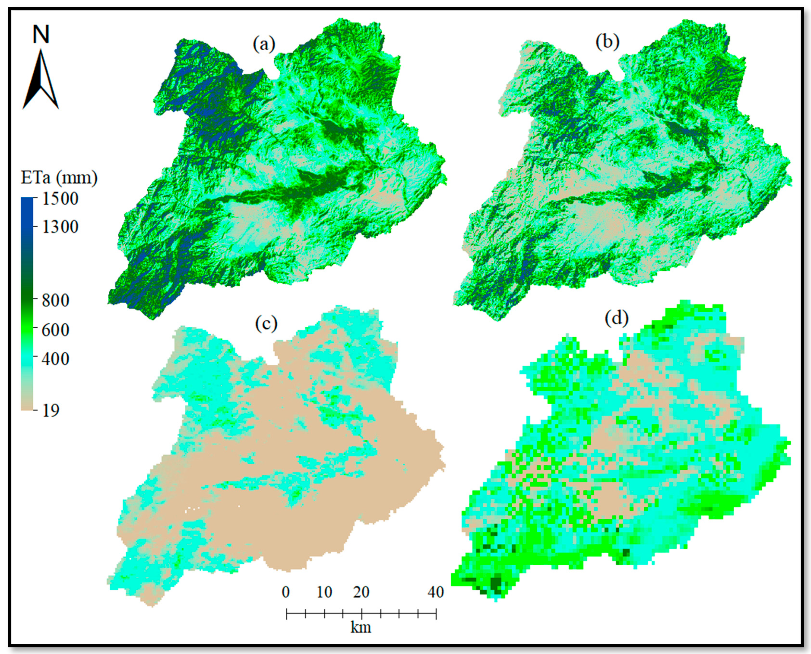
Figure 3 shows the one-year ETa map of Khost Province estimated by the GCOM-C algorithm, shown with the maps of three other data sources. The ETa estimated by the GCOM-C ETindex algorithm for rangelands in the lower flat region shows the lowest annual ETa, ranging from 450 mm to 700 mm. Wheat and maize are the dominant crops in these areas. Other regions, such as irrigated agricultural land and high mountain areas, have higher ETa values, ranging from 700 mm to 1400 mm. Similar results were obtained by Tasumi in 2019, where he estimated the actual evapotranspiration in the western Urmia Lake basin using the METRIC model [38]. He estimated the ET for various locations, including rainfed wheat, irrigated agriculture, short crops, city center, and Urmia lake. His estimated annual ET values from three rainfed wheat fields ranged from 316 to 652 mm yr−1, while in other favorable growing years (2014 and 2015 for location 9 and 2015 location 10), the estimated ET for wheat was reported as 652, 605, and 470 mm yr−1, while for horticultural crops, these values ranged from 650 to 1300 mm yr−1.
Table 2 shows the average ETa as estimated by the GCOM-C ETindex algorithm for the sampled locations of the four crops and bare soil, as indicated in Figure 1 on a monthly basis. The gray color in the table indicates the primary cultivation seasons for the respective crops and the whole 12 months for the bare soil surface. The ETa values for wheat, maize, and rice were somewhat similar regardless of their cultivation seasons because double-cropping is popularly conducted in the irrigated fields in this study area. These results align with those of several other studies. For example, a study conducted at the University of Nebraska—Lincoln reported the ETa for maize under full irrigation, limited irrigation, and rainfed conditions, and reported ETa values of 620 mm and 634 mm under irrigated conditions [39]. Similarly, a study on wheat in Inshas, Egypt, reported ETa values of 521 mm, 585 mm, and 571 mm under irrigated conditions for three different wheat varieties, respectively [28]. For rice, a research study conducted in Senegal, West Africa, reported the seasonal ETa as ranging from 632 mm to 929 mm [40].

3.2. Comparison of Estimated ETa with METRIC, MOD16, SEBS ETa, and FAO-56 ETc

The statistical data shown in Table 3 show that the GCOM-C ETa estimates were similar to those of METRIC ETa and FAO-56 ETc at the selected sample areas. The null hypothesis was that there would be no differences in the ET estimation results of the five different estimation approaches. The paired samples t-tests (Table 3) show that there is no statistically significant difference between GCOM-C and METRIC, or between GCOM-C and FAO-56 for the selected p value of 0.05 (p > 0.05). We, therefore, accept the null hypothesis for these pairs of estimates. On the other hand, there is a significant difference between the ET estimates of GCOM-C and MOD16 as well as between GCOM-C and SEBS, with p < 0.05 and a rejection of the null hypothesis. In a research study conducted across Asia, actual ET data from MOD16 were compared with data from 17 stations within the AsianFlux network [41]. They reported poor performance of MOD16 in arid regions with r2 values of 0.014. Similarly, a research study conducted in Qom province and the central desert margin of Iran showed a lower accuracy of MOD16 in dry areas [42].
In order to perform a more detailed seasonal analysis, the estimated monthly ETa by the GCOM-C ETindex algorithm for the November 2016-October 2017 cropping season was compared with the estimated ET by METRIC, MOD16, SEBS, and FAO-56 (Figure 4). The SEBS ETa data were for the 2012–2013 cropping season. Therefore, the difference between the SEBS ETa and the ET estimated by other models may not only represent the difference between the estimation algorithms but also the difference between the years. However, the year-to-year variation in the ETa is not expected to be large for agricultural surfaces such as wheat, maize, rice, and orchards in southeastern Afghanistan because they are irrigated, and crop rotation is not very popular in the region. The ETa from GCOM-C agreed well with those of METRIC and FAO-56 in all sample locations. Greater deviations from the GCOM-C estimates were identified for MOD16 and SEBS, which were much lower than the METRIC and FAO-56 estimates. It has been reported before that MOD16 tends to underestimate the ETa in irrigated agricultural settings [8], which is also indicated in our results (Figure 4). Similarly, a research study conducted in the Urmia Lake Basin, Iran, reported that ETa estimation by MOD16 was 35% lower than that estimated by FAO-56 [18].
The agreements among GCOM-C, METRIC, and FAO-56 support the successful estimation by the GCOM-C algorithm, although the three algorithms are not entirely independent of each other in our application. The GCOM-C and METRIC algorithms employed identical Landsat 8 thermal images as the input data. Additionally, GCOM-C, METRIC, and FAO-56 shared the same input weather data and applied similar reasoning by using Penman–Monteith-type equations to compute the actual or standard ET. This commonality likely contributes to the strong agreements observed.
Notably, the comparisons of the various algorithms appear consistent across different crops, with one exception: the unique trend of the ETa by SEBS from February to October. During this period (Figure 4), the ETa by SEBS was considerably larger than that by MOD16 and, at times, similar to or even larger than that by METRIC and the soil water balance method. The bare soil, which is not irrigated, can respond to precipitation quite erratically. Therefore, this particular result warrants careful interpretation and is not discussed in detail here. The average monthly differences between GCOM-C and METRIC were 2.14, 5.80, 5.67, −0.08, and 3.67 mm per month for wheat, maize, rice, orchards, and bare soil, respectively. Furthermore, the average monthly differences between GCOM-C and FAO-56 were −6.24, 6.98, 1.88, 9.10, and 0.54 mm per month for the same surfaces.
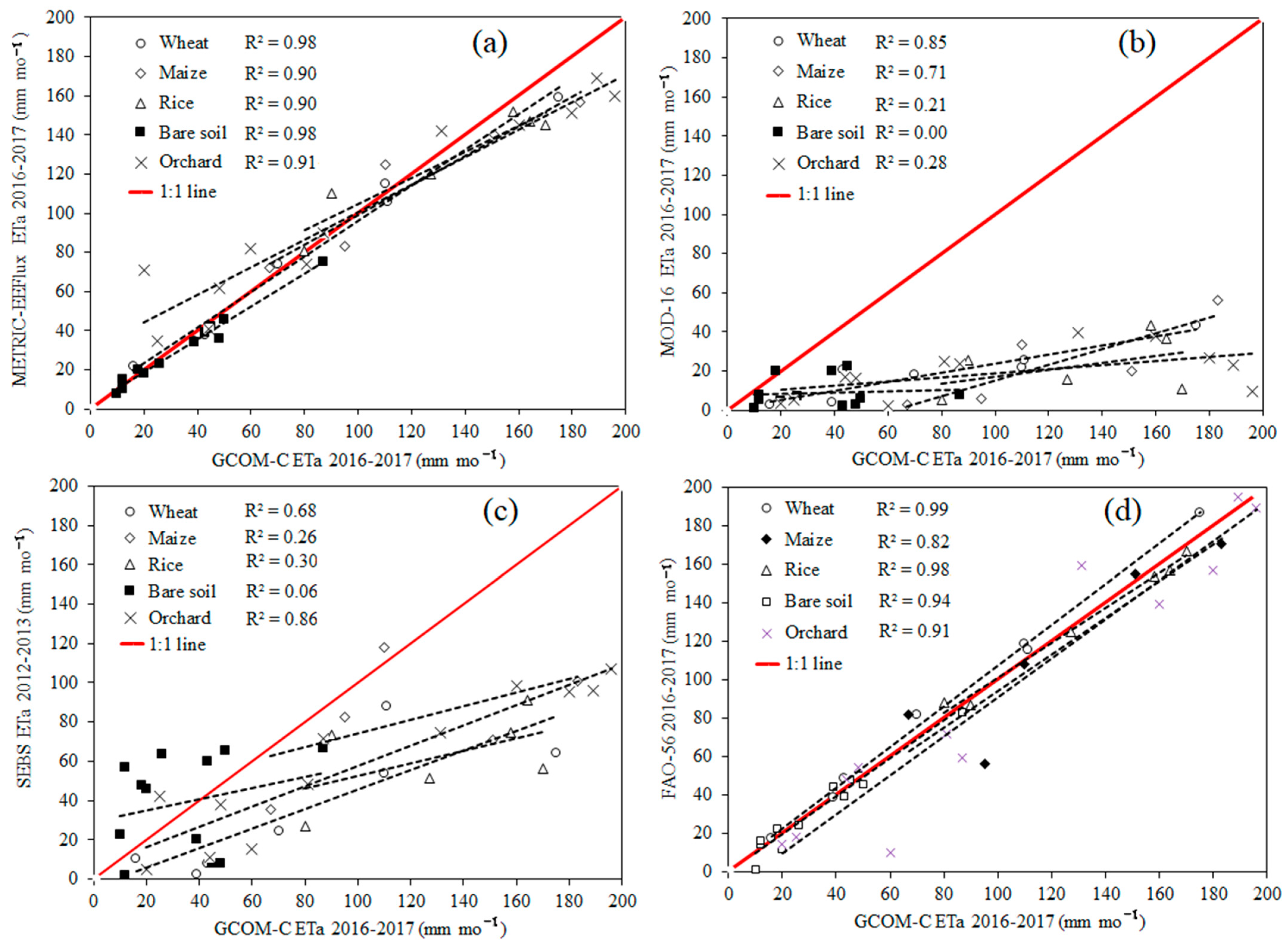
Figure 5 presents scatterplots comparing the ETa estimated by GCOM-C with those estimated by METRIC, MOD16, SEBS, and the ETc by FAO-56. Strong linear relationships were found between the ET estimates by GCOM-C and METRIC, as well as between GCOM-C and FAO-56, for all crop types and bare soil. For these model combinations, the scatterplots lie near the 1:1 line, and the coefficients of determination exceeded 0.90 for most land-use types. In contrast, the ETa estimates by SEBS and MOD16 were significantly lower than those by GCOM-C, with coefficients of determination ranging from 0.21 to 0.86.
Among the various land surfaces, wheat exhibited the highest agreement across all five models. SEBS performed particularly well for orchards compared to other land-use surfaces (Figure 5c). Conversely, MOD16 showed weak agreement for rice land surfaces, with a coefficient of determination of 0.21. These findings align with those from other similar studies using MOD16, which reported r² values of 0.27 for rice paddy cropland [41]. These findings highlight the reliability of the GCOM-C algorithm in estimating ET when compared with METRIC and FAO-56, likely due to their shared input data and similar computational approaches. However, its observed differences from SEBS and MOD16 underscore the need for further refinement and validation, particularly in arid and semi-arid regions.
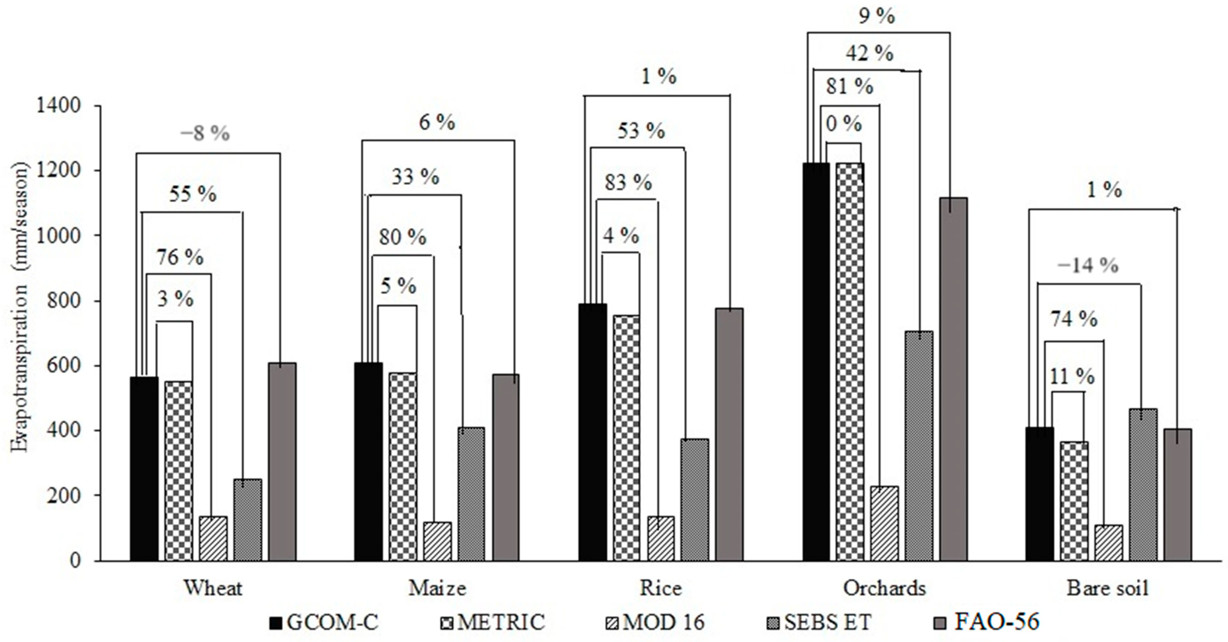
Finally, we compared the seasonal ET with various methods and crop types in Figure 6. On the seasonal timescale, the difference in ET as estimated by GCOM-C and METRIC was only between 0% and 11% (average 4.6%) for various crops and bare soil. The difference between GCOM-C and FAO-56 was −8% to 9%, averaging at 1.8%. SEBS and MOD16 showed larger differences. Although the series of comparisons made in this study do not provide a truly independent evaluation of the GCOM-C ET estimation algorithm because directly measured data of ETa were not available, the results convincingly show an excellent agreement of the algorithm with data from the METRIC algorithm, as well as a good agreement with the FAO-56 Penman–Monteith approach.

4. Conclusions

We evaluated the performance of the GCOM-C ETindex estimation algorithm in the semi-arid southeastern province of Afghanistan known as Khost. Data from a local meteorological station and Landsat- 8 Band 10 imagery (100-m resolution) were employed to estimate the actual evapotranspiration at monthly and seasonal resolutions for various irrigated crop types and for bare soil. Note that the area allows two cropping seasons per year: the winter crop season from November to May, and the summer crop season from May or June to October. The evaluation was made by comparing the results to four other ET data estimates. The ETa estimated by GCOM-C showed excellent consistency with the METRIC approach and very good agreement with the FAO-56 ETc approach. Generally, strong linear relationships were found between the ET estimates by GCOM-C and METRIC, as well as between GCOM-C and FAO-56, for all crop types and bare soil. For these two model combinations, the scatterplots were close to the 1:1 line, with coefficients of determination exceeding 0.90 for most land-use types. In contrast, the ETa estimates by SEBS and MOD16 were lower than those by GCOM-C, with coefficients of determination ranging from 0.21 to 0.86. Additionally, the MOD16 model could be improved especially for arid and semi-arid regions. This lets us conclude that the GCOM-C ETindex estimation algorithm is a very good, powerful, and easy-to-use tool to estimate the actual evapotranspiration for the climate and crops studied here. This study provides the first high-quality evapotranspiration estimation for the southeastern part of Afghanistan at the resolution of Landsat-8 Band 10 data, for monthly or seasonal timescales. It can be readily applied to larger areas, other years, and other crop types. Therefore, this estimation procedure and its results may not only contribute to better, sustainable water management in irrigated agro-systems but may also lead to a better understanding of hydrological processes on a regional, and likely, sub-continental scale. We will further evaluate the algorithm in other climates, in different eco-physiological boundary conditions, and by comparing the results with evapotranspiration data as directly measured with eddy covariance.

Author Contributions

Conceptualization, E.W. and M.T.; methodology, E.W. and M.T.; software, E.W.; validation, O.K., M.T. and E.W.; formal analysis, E.W.; investigation, E.W.; resources, O.K.; data curation, O.K.; writing—original draft preparation, E.W.; writing—review and editing, O.K. and M.T.; visualization, M.T.; supervision, O.K. All authors have read and agreed to the published version of the manuscript.

Funding

This research was supported by the 2nd Research Announcement on Earth Observations of the Japan Aerospace Exploration Agency (JAXA, EO-RA2-2018). Also, one author of this research paper is supported by the Philipp Schwartz Initiative (PSI 2022).

Data Availability Statement

All data are available from the authors on request.

Acknowledgments

We acknowledge the final language editing of the manuscript by C. Brennecka.

Conflicts of Interest

The authors declare no conflicts of interest.

References

  1. Black, M. The Atlas of Water; University of California Press: Oakland, CA, USA, 2016. [Google Scholar] [CrossRef]
  2. Abdelfattah, M.A.; Shahid, S.A. A Comparative Characterization and Classification of Soils in Abu Dhabi Coastal Area in Relation to Arid and Semi-Arid Conditions Using USDA and FAO Soil Classification Systems. Arid. Land. Res. Manag. 2007, 21, 245–271. [Google Scholar] [CrossRef]
  3. Da Silva, J.L.B.; Bezerra, A.C.; de Moura, G.B.A.; Jardim, A.M.d.R.F.; Batista, P.H.D.; de Jesus, F.L.F.; Sanches, A.C.; da Silva, M.V. Spatiotemporal Dynamics of Agricultural Areas with Central Pivot Using Orbital Remote Sensing in the Brazilian Semiarid. Smart Agric. Technol. 2022, 2, 100052. [Google Scholar] [CrossRef]
  4. Abbaszadeh Afshar, F.; Ayoubi, S.; Jafari, A. The Extrapolation of Soil Great Groups Using Multinomial Logistic Regression at Regional Scale in Arid Regions of Iran. Geoderma 2018, 315, 36–48. [Google Scholar] [CrossRef]
  5. Allen, R.G.; Pereira, L.S.; Raes, D.; Smith, M. Crop Evapotranspiration-Guidelines for Computing Crop Water Requirements; FAO Irrigation and Drainage Paper 56; FAO: Rome, Italy, 1998; Volume 300, p. D05109. [Google Scholar]
  6. Salazar, L.; Tolisano, J.; Crane, K.; Wheeler, L.; Kuile, M.T.; Radtke, D. Irrigation Reference Manual; Information Collection & Exchange; Peace Corps: Washington, DC, USA, 1994; pp. 85–94. [Google Scholar]
  7. Jensen, M.E.; Allen, R.G. Evaporation, Evapotranspiration, and Irrigation Water Requirements; ASCE Press: Reston, VA, USA, 2016; pp. 1–744. [Google Scholar] [CrossRef]
  8. Biggs, T.; Petropoulos, G.P.; Velpuri, N.M.; Marshall, M.; Glenn, E.P.; Nagler, P.; Messina, A. Remote Sensing of Actual Evapotranspiration from Croplands. In Remote Sensing of Water Resources, Disasters, and Urban Studies; Thenkabail, P.S., Ed.; CRC Press: Boca Raton, FL, USA, 2015; pp. 59–100. [Google Scholar]
  9. Bastiaanssen, W.G.M.; Menenti, M.; Feddes, R.A.; Holtslag, A.A.M. A Remote Sensing Surface Energy Balance Algorithm for Land (SEBAL). 1. Formulation. J. Hydrol. 1998, 212–213, 198–212. [Google Scholar] [CrossRef]
  10. Bastiaanssen, W.G.M.; Pelgrum, H.; Wang, J.; Ma, Y.; Moreno, J.F.; Roerink, G.J.; Van Der Wal, T. A Remote Sensing Surface Energy Balance Algorithm for Land (SEBAL).: Part 2: Validation. J. Hydrol. 1998, 212–213, 213–229. [Google Scholar] [CrossRef]
  11. Su, Z. The Surface Energy Balance System (SEBS) for Estimation of Turbulent Heat Fluxes. Hydrol. Earth Syst. Sci. 2002, 6, 85–100. [Google Scholar] [CrossRef]
  12. Allen, R.G.; Tasumi, M.; Trezza, R. Satellite-Based Energy Balance for Mapping Evapotranspiration with Internalized Calibration (METRIC)—Model. J. Irrig. Drain. Eng. 2007, 133, 380–394. [Google Scholar] [CrossRef]
  13. Allen, R.G.; Tasumi, M.; Morse, A.; Trezza, R.; Wright, J.L.; Bastiaanssen, W.; Kramber, W.; Lorite, I.; Robison, C.W. Satellite-Based Energy Balance for Mapping Evapotranspiration with Internalized Calibration (METRIC)—Applications. J. Irrig. Drain. Eng. 2007, 133, 395–406. [Google Scholar] [CrossRef]
  14. Running, S.W.; Mu, Q.; Zhao, M.; Moreno, A. MODIS Global Terrestrial Evapotranspiration (ET) Product (MOD16A2/A3 and Year-End Gap-Filled MOD16A2GF/A3GF) NASA Earth Observing System MODIS Land Algorithm (for Collection 6); data set; National Aeronautics and Space Administration: Washington, DC, USA, 2019; Volume 6. [CrossRef]
  15. Drexler, J.Z.; Snyder, R.L.; Spano, D.; Paw, U.K.T. A Review of Models and Micrometeorological Methods Used to Estimate Wetland Evapotranspiration. Hydrol. Process 2004, 18, 2071–2101. [Google Scholar] [CrossRef]
  16. Allen, R.G.; Trezza, R.; Kilic, A.; Tasumi, M.; Li, H. Sensitivity of Landsat-Scale Energy Balance to Aerodynamic Variability in Mountains and Complex Terrain. J. Am. Water Resour. Assoc. 2013, 49, 592–604. [Google Scholar] [CrossRef]
  17. Tasumi, M.; Moriyama, M.; Shinohara, Y. Application of GCOM-C SGLI for Agricultural Water Management via Field Evapotranspiration. Paddy Water Environ. 2019, 17, 75–82. [Google Scholar] [CrossRef]
  18. Tasumi, M.; Moriyama, M. Evapotranspiration Estimation of Urmia Lake Basin Using GCOM-C Thermal Imagery. IOP Conf. Ser. Earth Environ. Sci. 2021, 958, 012010. [Google Scholar] [CrossRef]
  19. Umeno, H.; Shinohara, Y.; Tasumi, M. Application of the GCOM-C Global ETindex Estimation Algorithm in 40 Forests Located throughout Japan, North America, Australia, and the Tropical Region. J. Agric. Meteorol. 2019, 75, 193–202. [Google Scholar] [CrossRef]
  20. Tasumi, M.; Moriyama, M.; Hirakawa, K.; Fujii, A. Evaluation of the GCOM-C Global ETindex Estimation Algorithm. J. Agric. Meteorol. 2016, 72, 151–158. [Google Scholar] [CrossRef]
  21. Da Silva, J.L.B.; da Silva, M.V.; Jardim, A.M.d.R.F.; Lopes, P.M.O.; de Oliveira, H.F.E.; Silva, J.A.O.S.; Mesquita, M.; de Carvalho, A.A.; Cézar Bezerra, A.; de Oliveira-Júnior, J.F.; et al. Geospatial Insights into Aridity Conditions: MODIS Products and GIS Modeling in Northeast Brazil. Hydrology 2024, 11, 32. [Google Scholar] [CrossRef]
  22. da Silva, J.L.B.; de Albuquerque Moura, G.B.; da Silva, M.V.; de Oliveira-Júnior, J.F.; Jardim, A.M.d.R.F.; Refati, D.C.; Lima, R.d.C.C.; de Carvalho, A.A.; Ferreira, M.B.; de Brito, J.I.B.; et al. Environmental Degradation of Vegetation Cover and Water Bodies in the Semiarid Region of the Brazilian Northeast via Cloud Geoprocessing Techniques Applied to Orbital Data. J. South. Am. Earth Sci. 2023, 121, 104164. [Google Scholar] [CrossRef]
  23. Tasumi, M.; Kimura, R.; Allen, R.G.; Moriyama, M.; Trezza, R. Development of the GCOM-C Global ETindex Estimation Algorithm. J. Agric. Meteorol. 2016, 72, 85–94. [Google Scholar] [CrossRef]
  24. Wali, E.; Tasumi, M.; Shinohara, Y.; Takeshita, S. Mapping Crop Types and Crop Water Requirements over Small-Sized Irrigated Fields in the Khost Province of Afghanistan. J. Rainwater Catchment Syst. 2019, 24, 9–15. [Google Scholar] [CrossRef]
  25. Akhtar, F.; Awan, U.K.; Tischbein, B.; Liaqat, U.W. Assessment of Irrigation Performance in Large River Basins under Data Scarce Environment—A Case of Kabul River Basin, Afghanistan. Remote Sens. 2018, 10, 972. [Google Scholar] [CrossRef]
  26. De Oliveira Costa, J.; José, J.V.; Wolff, W.; de Oliveira, N.P.R.; Oliveira, R.C.; Ribeiro, N.L.; Coelho, R.D.; da Silva, T.J.A.; Bonfim-Silva, E.M.; Schlichting, A.F. Spatial Variability Quantification of Maize Water Consumption Based on Google EEflux Tool. Agric. Water Manag. 2020, 232, 106037. [Google Scholar] [CrossRef]
  27. Venancio, L.P.; Eugenio, F.C.; Filgueiras, R.; Da Cunha, F.F.; Dos Santos, R.A.; Ribeiro, W.R.; Mantovan, E.C. Mapping Within-field Variability of Soybean Evapotranspiration and Crop Coefficient Using the Earth Engine Evaporation Flux (EEFlux) Application. PLoS ONE 2020, 15, e0235620. [Google Scholar] [CrossRef] [PubMed]
  28. Salama, M.A.; Yousef, K.M.; Mostafa, A.Z. Simple Equation for Estimating Actual Evapotranspiration Using Heat Units for Wheat in Arid Regions. J. Radiat. Res. Appl. Sci. 2015, 8, 418–427. [Google Scholar] [CrossRef]
  29. Wali, E.; Datta, A.; Shrestha, R.P.; Shrestha, S. Development of a Land Suitability Model for Saffron (Crocus sativus L.) Cultivation in Khost Province of Afghanistan Using GIS and AHP Techniques. Arch. Agron. Soil. Sci. 2016, 62, 921–934. [Google Scholar] [CrossRef]
  30. NASA; METI. AIST, Japan Spacesystems, US/Japan ASTER Science Team. ASTER Global Digital Elevation Model 3; NASA: Washington, DC, USA, 2009; Volume 3.
  31. Irmak, A.; Allen, R.G.; Kjaersgaard, J.; Huntington, J.; Kamble, B.; Trezza, R.; Ratcliffe, I.; Irmak, A.; Allen, R.G.; Kjaersgaard, J.; et al. Operational Remote Sensing of ET and Challenges. In Evapotranspiration-Remote Sensing and Modeling; InTech Open: London, UK, 2012. [Google Scholar] [CrossRef]
  32. Rodell, M.; Houser, P.R.; Jambor, U.; Gottschalck, J.; Mitchell, K.; Meng, C.J.; Arsenault, K.; Cosgrove, B.; Radakovich, J.; Bosilovich, M.; et al. The Global Land Data Assimilation System. Bull. Am. Meteorol. Soc. 2004, 85, 381–394. [Google Scholar] [CrossRef]
  33. Brutsaert, W.; Stricker, H. An Advection-Aridity Approach to Estimate Actual Regional Evapotranspiration. Water Resour. Res. 1979, 15, 443–450. [Google Scholar] [CrossRef]
  34. Liaqat, U.W.; Choi, M.; Awan, U.K. Spatio-Temporal Distribution of Actual Evapotranspiration in the Indus Basin Irrigation System. Hydrol. Process 2015, 29, 2613–2627. [Google Scholar] [CrossRef]
  35. Hargreaves, G.H.; Samani, Z.A. Reference Crop Evapotranspiration from Temperature. Appl. Eng. Agric. 1985, 1, 96–99. [Google Scholar] [CrossRef]
  36. Li, Z.L.; Tang, R.; Wan, Z.; Bi, Y.; Zhou, C.; Tang, B.; Yan, G.; Zhang, X. A Review of Current Methodologies for Regional Evapotranspiration Estimation from Remotely Sensed Data. Sensors 2009, 9, 3801–3853. [Google Scholar] [CrossRef]
  37. Stancalie, G.; Marica, A.; Toulios, L. Using Earth Observation Data and CROPWAT Model to Estimate the Actual Crop Evapotranspiration. Phys. Chem. Earth 2010, 35, 25–30. [Google Scholar] [CrossRef]
  38. Tasumi, M. Estimating Evapotranspiration Using METRIC Model and Landsat Data for Better Understandings of Regional Hydrology in the Western Urmia Lake Basin. Agric. Water Manag. 2019, 226, 105805. [Google Scholar] [CrossRef]
  39. Djaman, K.; Irmak, S. Actual Crop Evapotranspiration and Alfalfa- and Grass-Reference Crop Coefficients of Maize under Full and Limited Irrigation and Rainfed Conditions. J. Irrig. Drain. Eng. 2012, 139, 433–446. [Google Scholar] [CrossRef]
  40. Djaman, K.; Mel, V.C.; Balde, A.B.; Bado, B.V.; Manneh, B.; Diop, L.; Mutiibwa, D.; Rudnick, D.R.; Irmak, S.; Futakuchi, K. Evapotranspiration, Irrigation Water Requirement, and Water Productivity of Rice (Oryza sativa L.) in the Sahelian Environment. Paddy Water Environ. 2017, 15, 469–482. [Google Scholar] [CrossRef]
  41. Kim, H.W.; Hwang, K.; Mu, Q.; Lee, S.O.; Choi, M. Validation of MODIS 16 Global Terrestrial Evapotranspiration Products in Various Climates and Land Cover Types in Asia. KSCE J. Civ. Eng. 2012, 16, 229–238. [Google Scholar] [CrossRef]
  42. Jahangir, M.H.; Arast, M. Remote Sensing Products for Predicting Actual Evapotranspiration and Water Stress Footprints under Different Land Cover. J. Clean Prod. 2020, 266, 121818. [Google Scholar] [CrossRef]
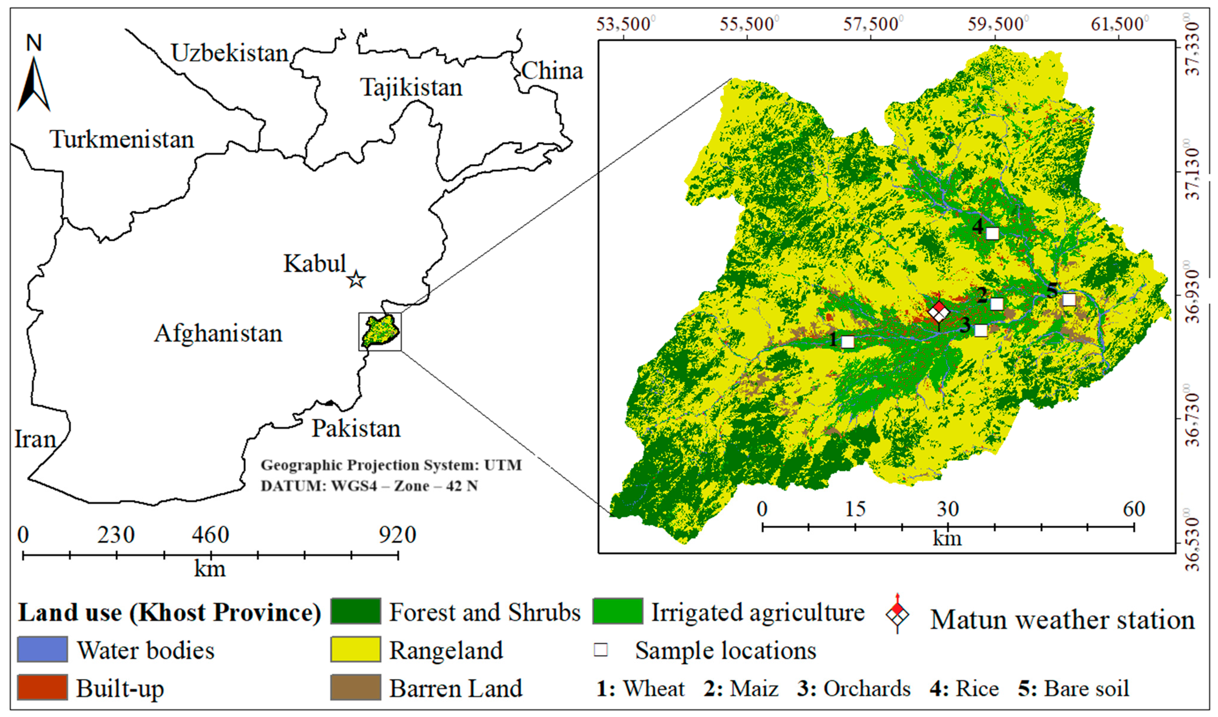
Figure 1. Location of study area with land cover and the sample point information.
Hydrology 11 00095 g001
Figure 2. Procedure for gap filling of ETindex image data for the month of February.
Hydrology 11 00095 g002
Figure 3. Maps of the total ETa from November 2016 to October 2017, estimated by (a) the GCOM-C ETindex algorithm, (b) METRIC-EEFlux, (c) MOD16, and (d) SEBS.
Hydrology 11 00095 g003
Figure 4. ETa estimated by GCOM-C, METRIC-EEFlux, MOD16, and FAO-56 for the 2016–2017 cropping season and by SEBS ETa for 2012–2013 cropping season.
Hydrology 11 00095 g004
Figure 5. Relationships between monthly ET estimates by GCOM-C (x-axes) and (a) METRIC, (b) MOD16, (c) SEBS, and (d) FAO-56 for Khost Province in SE Afghanistan.
Hydrology 11 00095 g005
Figure 6. Estimated seasonal ET with reference values for wheat, maize, rice, orchards, and bare soil.
Hydrology 11 00095 g006
Table 1. Availability of Landsat 8 images from November 2016 to October 2017 and their usage for the study area.
Image #DateUsageImage #DateUsage
17 November 16Used1318 May 17Not used
223 November 16Used143 June 17Used
39 December 16Used1519 June 17Used
425 December 16Used165 July 17Used
510 January17Used1721 July 17Not used
626 January 17Used186 August 17Limited use
711 February 17Limited use1922 August 17Not used
827 February 17Used207 September 17Limited use
915 March 17Used2123 September 17Used
1031 March 17Not used229 October 17Used
1116 April 17Used2325 October 17Used
122 May 17Used
Table 2. Estimated monthly ETa (mm) by crops and bare soil in the study area, as estimated with the GCOM-C ETindex algorithm. The gray color in the table indicates the primary cultivation seasons for the respective crops and the whole 12 months for the bare soil surface.
MonthsWheatMaizeRiceOrchardsBare Soil
November 20161618226048
December 20163940542012
January 20174345484445
February 20177075774839
March 20171101151188118
April 201717516016513112
May 20171111089018926
June 2017989517019643
July 201711211015818087
August 201717518316416050
September 20171481511278720
October 20177167802510
Total ETa/Season5646067891221410
Table 3. Paired samples t-test results for comparing monthly ETa as estimated by GCOM-C with ETa estimated by METRIC, MOD16, SEBS, and FAO-56.
Paired DifferencestdfSig. (2-Tailed)
MeanStd. Error Mean95% Confidence Interval of the Difference
LowerUpper
Pair 1GCOM-C—METRIC2.882.33−1.827.581.23410.22
Pair 2GCOM-C—MOD1668.137.8252.3283.948.70410.00
Pair 3GCOM-C—SEBS32.986.2920.2645.705.23410.00
Pair 4GCOM-C—FAO-562.752.13−1.557.071.29410.20
Disclaimer/Publisher’s Note: The statements, opinions and data contained in all publications are solely those of the individual author(s) and contributor(s) and not of MDPI and/or the editor(s). MDPI and/or the editor(s) disclaim responsibility for any injury to people or property resulting from any ideas, methods, instructions or products referred to in the content.