Spatio-Temporal Behavior of Land Surface Temperatures (LSTs) in Central Chile, Using Terra MODIS Images
Abstract
1. Introduction
2. Materials and Methods
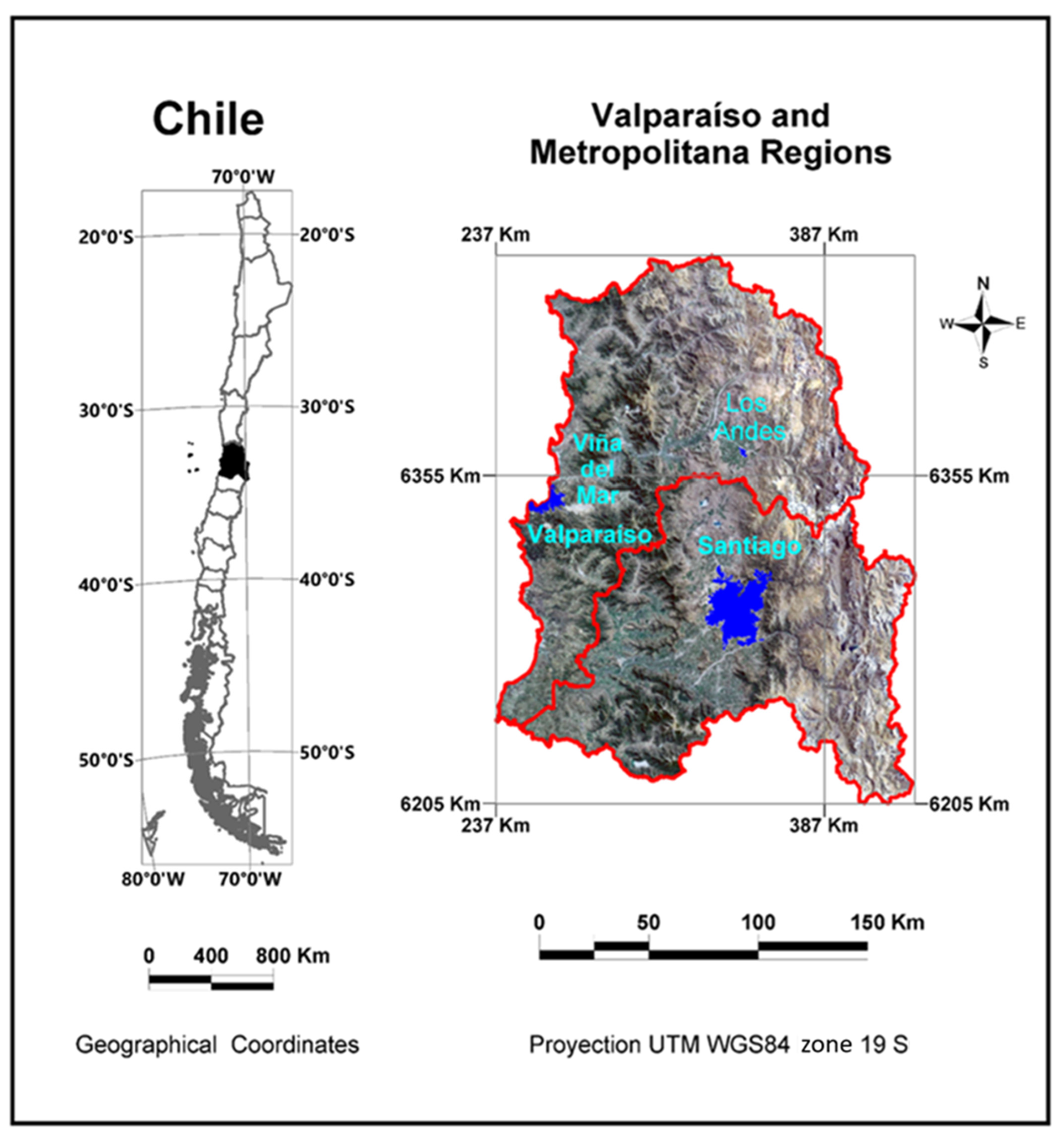
2.1. Study Area
2.2. Satellite Information
2.3. Downloading and Image Processing
Calculation of LST Anomalies
2.4. Estimation of the Trend and Its Significance
2.5. Significance Threshold Calculation
2.6. Regression’s Slope Calculation
2.7. Rasterization of Land Uses and Geomorphology Maps
2.8. Obtaining Trend Values for Each Use and Geomorphological Type
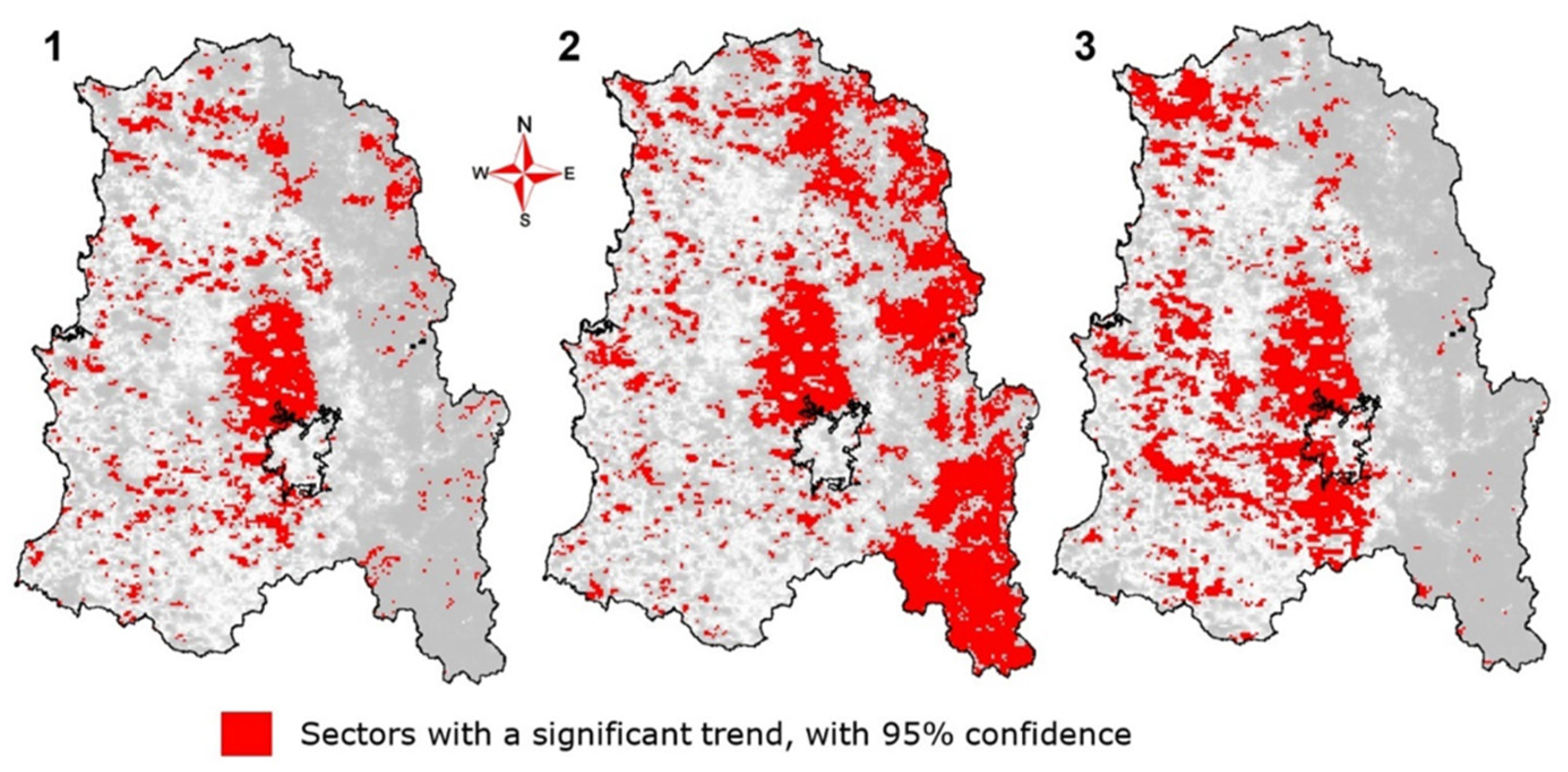
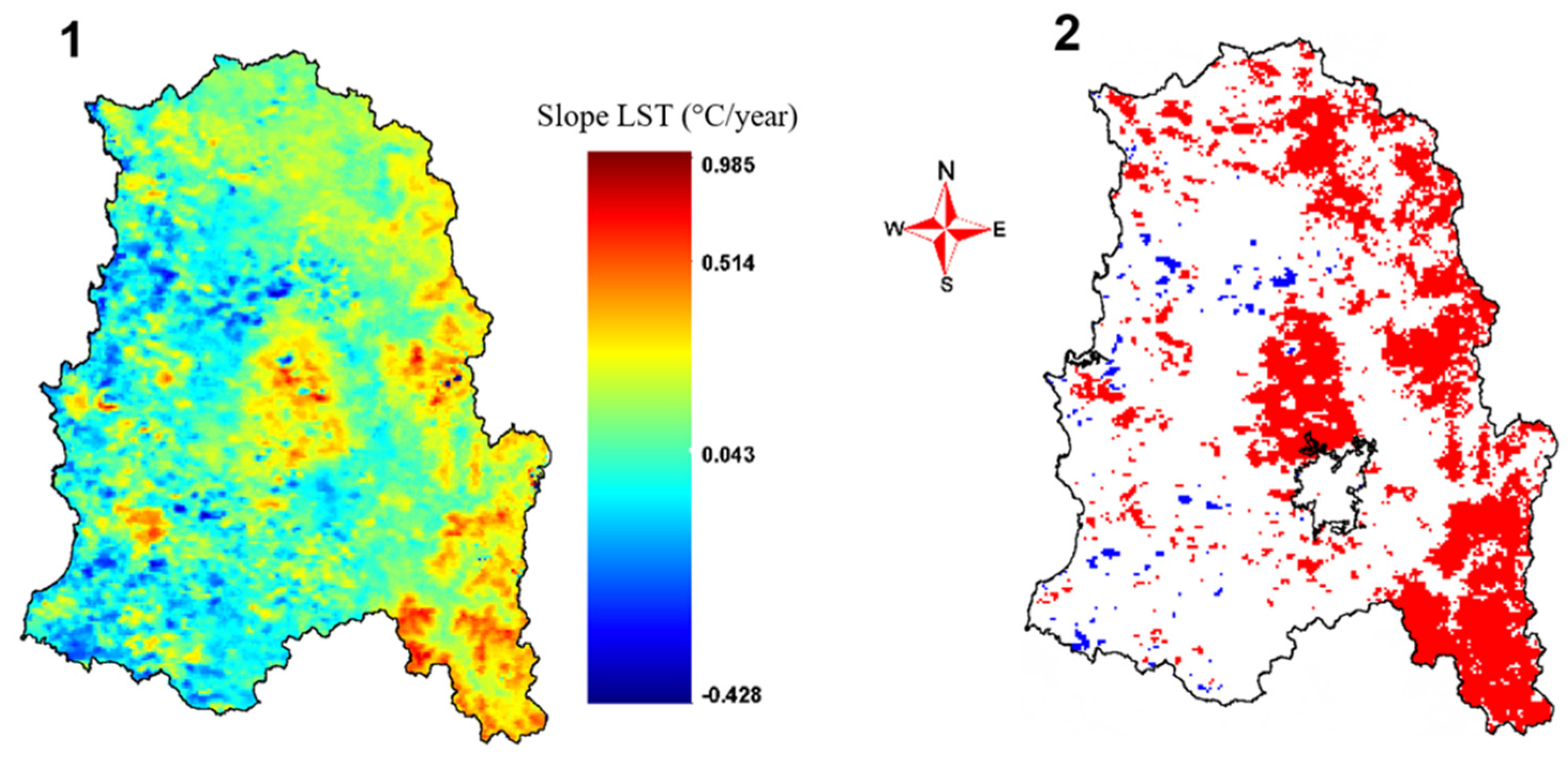
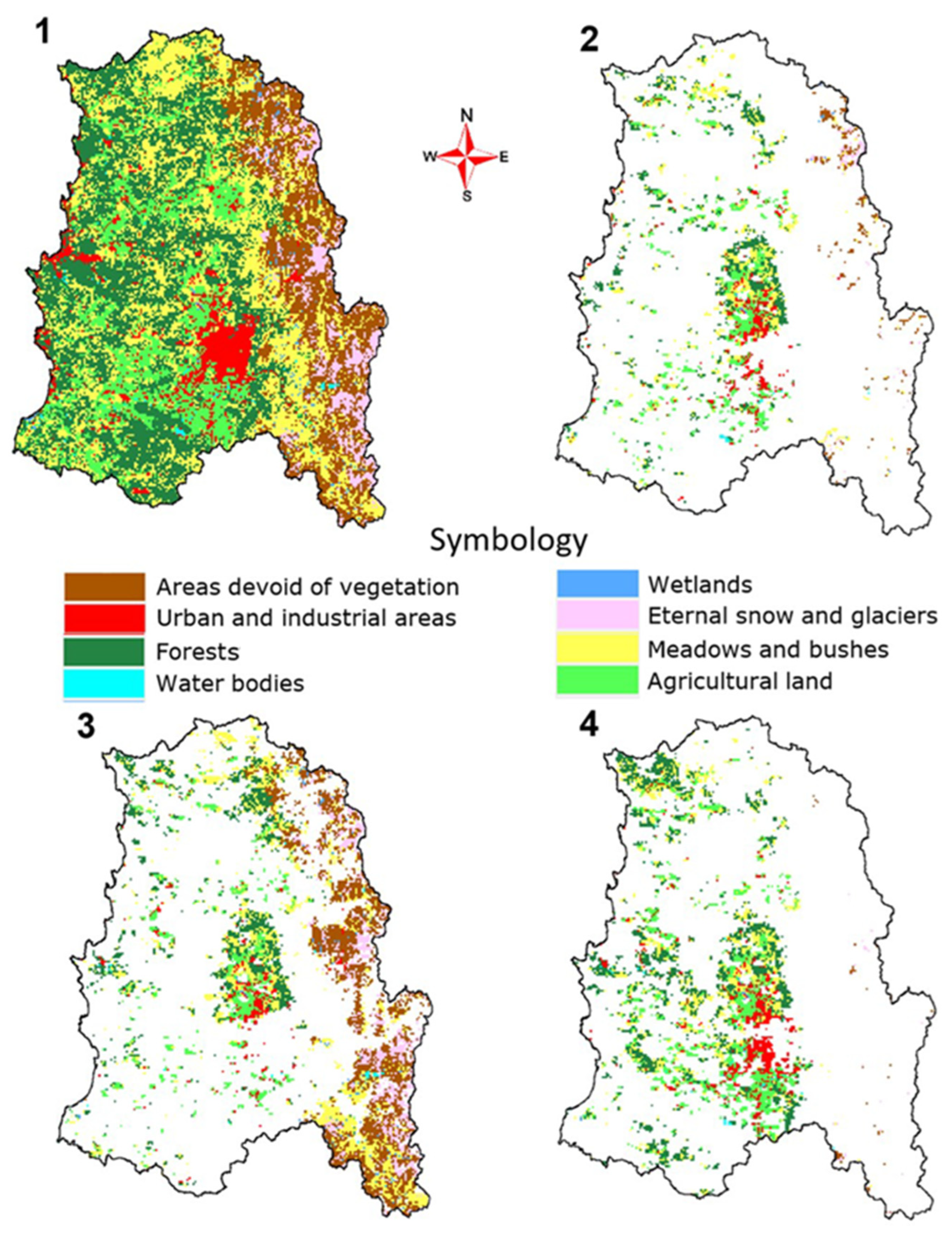
3. Results
4. Discussion
5. Conclusions
Author Contributions
Funding
Data Availability Statement
Conflicts of Interest
References
- Brunsell, N.A.; Gillies, R.R. Length Scale Analysis of Surface Energy Fluxes Derived from Remote Sensing. J. Hydrometeor 2003, 4, 1212–1219. [Google Scholar] [CrossRef]
- Anderson, M.; Norman, J.; Kustas, W.; Houborg, R.; Starks, P.; Agam, N. A Thermal-Based Remote Sensing Technique for Routine Mapping of Land-Surface Carbon, Water and Energy Fluxes from Field to Regional Scales. Remote Sens. Environ. 2008, 112, 4227–4241. [Google Scholar] [CrossRef]
- Reiners, P.; Sobrino, J.; Kuenzer, C. Satellite-Derived Land Surface Temperature Dynamics in the Context of Global Change—A Review. Remote Sens. 2023, 15, 1857. [Google Scholar] [CrossRef]
- Sobrino, J.A.; Julien, Y. Trend Analysis of Global MODIS-Terra Vegetation Indices and Land Surface Temperature Between 2000 and 2011. IEEE J. Sel. Top. Appl. Earth Obs. Remote Sens. 2013, 6, 2139–2145. [Google Scholar] [CrossRef]
- Sobrino, J.A.; Julien, Y.; García-Monteiro, S. Surface Temperature of the Planet Earth from Satellite Data. Remote Sens. 2020, 12, 218. [Google Scholar] [CrossRef]
- Kerr, Y.H.; Lagouarde, J.P.; Imbernon, J. Accurate Land Surface Temperature Retrieval from AVHRR Data with Use of an Improved Split Window Algorithm. Remote Sens. Environ. 1992, 41, 197–209. [Google Scholar] [CrossRef]
- Solanky, V.; Singh, S.; Katiyar, S.K. Land Surface Temperature Estimation Using Remote Sensing Data. In Hydrologic Modeling; Singh, V.P., Yadav, S., Yadava, R.N., Eds.; Springer: Singapore, 2018; Volume 81, pp. 343–351. ISBN 978-981-10-5800-4. [Google Scholar]
- Li, Z.; Wu, H.; Duan, S.; Zhao, W.; Ren, H.; Liu, X.; Leng, P.; Tang, R.; Ye, X.; Zhu, J.; et al. Satellite Remote Sensing of Global Land Surface Temperature: Definition, Methods, Products, and Applications. Rev. Geophys. 2023, 61, e2022RG000777. [Google Scholar] [CrossRef]
- Hansen, J.; Ruedy, R.; Sato, M.; Lo, K. Global Surface Temperature Change. Rev. Geophys. 2010, 48, RG4004. [Google Scholar] [CrossRef]
- Bendib, A.; Dridi, H.; Kalla, M.I. Contribution of Landsat 8 Data for the Estimation of Land Surface Temperature in Batna City, Eastern Algeria. Geocarto Int. 2017, 32, 503–513. [Google Scholar] [CrossRef]
- Yuvaraj, R.M. Extents of Predictors for Land Surface Temperature Using Multiple Regression Model. Sci. World J. 2020, 2020, 1–10. [Google Scholar] [CrossRef]
- Rosas-Chavoya, M.; López-Serrano, P.M.; Vega-Nieva, D.J.; Wehenkel, C.A.; Hernández-Díaz, J.C. Application of Land Surface Temperature from Landsat Series to Monitor and Analyze Forest Ecosystems: A Bibliometric Analysis. For. Syst. 2022, 31, e021. [Google Scholar] [CrossRef]
- Ullah, W.; Ahmad, K.; Ullah, S.; Tahir, A.A.; Javed, M.F.; Nazir, A.; Abbasi, A.M.; Aziz, M.; Mohamed, A. Analysis of the Relationship among Land Surface Temperature (LST), Land Use Land Cover (LULC), and Normalized Difference Vegetation Index (NDVI) with Topographic Elements in the Lower Himalayan Region. Heliyon 2023, 9, e13322. [Google Scholar] [CrossRef] [PubMed]
- Townshend, J.R.G.; Justice, C.O. Selecting the Spatial Resolution of Satellite Sensors Required for Global Monitoring of Land Transformations. Int. J. Remote Sens. 1988, 9, 187–236. [Google Scholar] [CrossRef]
- Voogt, J.A.; Oke, T.R. Complete Urban Surface Temperatures. J. Appl. Meteor. 1997, 36, 1117–1132. [Google Scholar] [CrossRef]
- Zhan, W.; Chen, Y.; Zhou, J.; Wang, J.; Liu, W.; Voogt, J.; Zhu, X.; Quan, J.; Li, J. Disaggregation of Remotely Sensed Land Surface Temperature: Literature Survey, Taxonomy, Issues, and Caveats. Remote Sens. Environ. 2013, 131, 119–139. [Google Scholar] [CrossRef]
- Mao, Q.; Peng, J.; Wang, Y. Resolution Enhancement of Remotely Sensed Land Surface Temperature: Current Status and Perspectives. Remote Sens. 2021, 13, 1306. [Google Scholar] [CrossRef]
- Pu, R.; Bonafoni, S. Thermal Infrared Remote Sensing Data Downscaling Investigations: An Overview on Current Status and Perspectives. Remote Sens. Appl. Soc. Environ. 2023, 29, 100921. [Google Scholar] [CrossRef]
- García, D.H.; Riza, M.; Díaz, J.A. Land Surface Temperature Relationship with the Land Use/Land Cover Indices Leading to Thermal Field Variation in the Turkish Republic of Northern Cyprus. Earth Syst Environ. 2023, 7, 561–580. [Google Scholar] [CrossRef]
- Julien, Y.; Sobrino, J.A. Correcting AVHRR Long Term Data Record V3 Estimated LST from Orbital Drift Effects. Remote Sens. Environ. 2012, 123, 207–219. [Google Scholar] [CrossRef]
- Julien, Y.; Sobrino, J.A. NOAA-AVHRR Orbital Drift Correction: Validating Methods Using MSG-SEVIRI Data as a Benchmark Dataset. Remote Sens. 2021, 13, 925. [Google Scholar] [CrossRef]
- Neteler, M. Estimating Daily Land Surface Temperatures in Mountainous Environments by Reconstructed MODIS LST Data. Remote Sens. 2010, 2, 333–351. [Google Scholar] [CrossRef]
- Sarricolea, P.; Martín-Vide, J. El Estudio de La Isla de Calor Urbana de Superficie Del Área Metropolitana de Santiago de Chile Con Imágenes Terra-MODIS y Análisis de Componentes Principales. Rev. Geogr. Norte Gd. 2014, 123–141. [Google Scholar] [CrossRef]
- Cheval, S.; Dumitrescu, A. The July Urban Heat Island of Bucharest as Derived from Modis Images. Theor. Appl. Clim. 2009, 96, 145–153. [Google Scholar] [CrossRef]
- Alshaikh, A.Y. Space Applications for Drought Assessment in Wadi-Dama (West Tabouk), KSA. Egypt. J. Remote Sens. Space Sci. 2015, 18, S43–S53. [Google Scholar] [CrossRef]
- Khandelwal, S.; Goyal, R.; Kaul, N.; Mathew, A. Assessment of Land Surface Temperature Variation Due to Change in Elevation of Area Surrounding Jaipur, India. Egypt. J. Remote Sens. Space Sci. 2018, 21, 87–94. [Google Scholar] [CrossRef]
- You, M.; Huang, J.; Guan, C. Are New Towns Prone to Urban Heat Island Effect? Implications for Planning Form and Function. Sustain. Cities Soc. 2023, 99, 104939. [Google Scholar] [CrossRef]
- Parida, B.R.; Oinam, B.; Patel, N.R.; Sharma, N.; Kandwal, R.; Hazarika, M.K. Land Surface Temperature Variation in Relation to Vegetation Type Using MODIS Satellite Data in Gujarat State of India. Int. J. Remote Sens. 2008, 29, 4219–4235. [Google Scholar] [CrossRef]
- Guha, S.; Govil, H.; Dey, A.; Gill, N. Analytical Study of Land Surface Temperature with NDVI and NDBI Using Landsat 8 OLI and TIRS Data in Florence and Naples City, Italy. Eur. J. Remote Sens. 2018, 51, 667–678. [Google Scholar] [CrossRef]
- Roy, B.; Bari, E. Examining the Relationship between Land Surface Temperature and Landscape Features Using Spectral Indices with Google Earth Engine. Heliyon 2022, 8, e10668. [Google Scholar] [CrossRef]
- Ramachandra, T.; Kumar, U.; Dasgupta, A. Analysis of Land Surface Temperature and Rainfall with Landscape Dynamics in Western Ghats, India; Indian Institute of Science: Bangalore, India, 2016. [Google Scholar]
- Jimenez-Munoz, J.C.; Sobrino, J.A.; Skokovic, D.; Mattar, C.; Cristobal, J. Land Surface Temperature Retrieval Methods From Landsat-8 Thermal Infrared Sensor Data. IEEE Geosci. Remote Sens. Lett. 2014, 11, 1840–1843. [Google Scholar] [CrossRef]
- Li, Z.-L.; Tang, B.-H.; Wu, H.; Ren, H.; Yan, G.; Wan, Z.; Trigo, I.F.; Sobrino, J.A. Satellite-Derived Land Surface Temperature: Current Status and Perspectives. Remote Sens. Environ. 2013, 131, 14–37. [Google Scholar] [CrossRef]
- Nichol, J. A GIS-Based Approach to Microclimate Monitoring in Singapore’s High-Rise Housing Estates. Photogramm. Eng. Remote Sens. 1994, 60, 1225–1232. [Google Scholar]
- Arnfield, A.J. Two Decades of Urban Climate Research: A Review of Turbulence, Exchanges of Energy and Water, and the Urban Heat Island. Int. J. Climatol. 2003, 23, 1–26. [Google Scholar] [CrossRef]
- Weng, Q. Thermal Infrared Remote Sensing for Urban Climate and Environmental Studies: Methods, Applications, and Trends. ISPRS J. Photogramm. Remote Sens. 2009, 64, 335–344. [Google Scholar] [CrossRef]
- Fan, X.-M.; Liu, H.-G.; Liu, G.-H.; Li, S.-B. Reconstruction of MODIS Land-Surface Temperature in a Flat Terrain and Fragmented Landscape. Int. J. Remote Sens. 2014, 35, 7857–7877. [Google Scholar] [CrossRef]
- Conaf Catastro de de Los Recursos Vegetacionales Nativos de Chile 2013. Available online: https://sit.conaf.cl/varios/Catastros_Recursos_Vegetacionales_Nativos_de_Chile_Nov2021.pdf (accessed on 18 June 2024).
- Fuentealba, A.; Duran, L.; Morales, N.S. The Impact of Forest Science in Chile: History, Contribution, and Challenges. Can. J. For. Res. 2021, 51, 753–765. [Google Scholar] [CrossRef]
- OTERRA—Escuela de Ingeniería Forestal de la Universidad Mayor; Ernst Basler + Partner; Agrupación de Ingenieros; Forestales por el Bosque Nativo (AIFBN); Centro de Información de Recursos Naturales (CIREN). Drivers of DD-Informe Causales, Chile; 2016; Available online: https://www.forestcarbonpartnership.org/system/files/documents/7-Drivers%20of%20DD-informe_causales_chile_espa%C3%B1ol.pdf (accessed on 18 June 2024).
- Börgel, R. Geografía de Chile. Geomorfología; Instituto Geográfico Militar: Santiago, Chile, 1983. [Google Scholar]
- Errázuriz, A.M. Manual de Geografía de Chile; Andrés Bello: Santiago, Chile, 1998; ISBN 978-956-13-1523-5. [Google Scholar]
- Sarricolea, P.; Herrera-Ossandon, M.; Meseguer-Ruiz, Ó. Climatic Regionalisation of Continental Chile. J. Maps 2017, 13, 66–73. [Google Scholar] [CrossRef]
- Dirección Meteorológica de Chile (DMC). Resumen Climático-Chile 2016; 2016; Available online: https://www.scribd.com/document/346586253/Resumen-Climatico-Chile-2016 (accessed on 15 March 2024).
- Wan, Z. Collection-6 MODIS Land Surface Temperature Products Users’ Guide; University of California: Santa Barbara, CA, USA, 2013. [Google Scholar]
- Wan, Z.; Simon, H.; Glynn, H. MOD11A2 MODIS/Terra Land Surface Temperature/Emissivity 8-Day L3 Global 1km SIN Grid V006. Nasa Eosdis Land Process. Daac 2015, 10. [Google Scholar] [CrossRef]
- Etienne, M.; Prado, C. Descripción de La Vegetación Mediante La Cartografía de Ocupación de Tierras. Conceptos y Manual de Uso Práctico; Universidad de Chile: Santiago, Chile, 1982. [Google Scholar]
- Albers, C. Unidades Geomorfológicas de Chile; Rulamahue, Temuco. 2016. Available online: https://www.rulamahue.cl/archive/cl_continental_archivos/cl_312_geomorfologia.pdf (accessed on 18 June 2024).
- Kendall, M. Rank Correlation Methods, 4th ed.; Charles Griffin: London, UK, 1975. [Google Scholar]
- Sangüesa, C.; Pizarro, R.; Ibañez, A.; Pino, J.; Rivera, D.; García-Chevesich, P.; Ingram, B. Spatial and Temporal Analysis of Rainfall Concentration Using the Gini Index and PCI. Water 2018, 10, 112. [Google Scholar] [CrossRef]
- Pizarro, R.; Garcia-Chevesich, P.A.; McCray, J.E.; Sharp, J.O.; Valdes-Pineda, R.; Sangüesa, C.; Jaque-Becerra, D.; Alvarez, P.; Norambuena, S.; Ibanez, A.; et al. Climate Change and Overuse: Water Resource Challenges during Economic Growth in Coquimbo, Chile. Sustainability 2022, 14, 3440. [Google Scholar] [CrossRef]
- Pohlert, T. Non-Parametric Trend Tests and Change-Point Detection, R package version 0.0.1; 2023. [Google Scholar] [CrossRef]
- Sen, P.K. Estimates of the Regression Coefficient Based on Kendall’s Tau. J. Am. Stat. Assoc. 1968, 63, 1379–1389. [Google Scholar] [CrossRef]
- Gilbert, R.O. Statistical Methods for Environmental Pollution Monitoring; Wiley: New York, NY, USA; Chichester, UK; Weinheim, Germnay, 1987; ISBN 978-0-471-28878-7. [Google Scholar]
- Boschetti, M.; Nutini, F.; Brivio, P.A.; Bartholomé, E.; Stroppiana, D.; Hoscilo, A. Identification of Environmental Anomaly Hot Spots in West Africa from Time Series of NDVI and Rainfall. ISPRS J. Photogramm. Remote Sens. 2013, 78, 26–40. [Google Scholar] [CrossRef]
- Sangüesa, C.; Pizarro, R.; Ingram, B.; Balocchi, F.; García-Chevesich, P.; Pino, J.; Ibáñez, A.; Vallejos, C.; Mendoza, R.; Bernal, A.; et al. Streamflow Trends in Central Chile. Hydrology 2023, 10, 144. [Google Scholar] [CrossRef]
- Yue, S.; Pilon, P.; Cavadias, G. Power of the Mann–Kendall and Spearman’s Rho Tests for Detecting Monotonic Trends in Hydrological Series. J. Hydrol. 2002, 259, 254–271. [Google Scholar] [CrossRef]
- Jiménez-Muñoz, J.C.; Mattar, C.; Sobrino, J.A.; Malhi, Y. Digital Thermal Monitoring of the Amazon Forest: An Intercomparison of Satellite and Reanalysis Products. Int. J. Digit. Earth 2016, 9, 477–498. [Google Scholar] [CrossRef]
- Mildrexler, D.; Yang, Z.; Cohen, W.B.; Bell, D.M. A Forest Vulnerability Index Based on Drought and High Temperatures. Remote Sens. Environ. 2016, 173, 314–325. [Google Scholar] [CrossRef]
- R Core Team. R: A Language and Environment for Statistical Computing; R Core Team: Vienna, Austria, 2021. [Google Scholar]
- Xiao, H.; Weng, Q. The Impact of Land Use and Land Cover Changes on Land Surface Temperature in a Karst Area of China. J. Environ. Manag. 2007, 85, 245–257. [Google Scholar] [CrossRef]
- Li, S.; Qin, Z.; Zhao, S.; Gao, M.; Li, S.; Liao, Q.; Du, W. Spatiotemporal Variation of Land Surface Temperature in Henan Province of China from 2003 to 2021. Land 2022, 11, 1104. [Google Scholar] [CrossRef]
- Chander, G.; Markham, B.L.; Barsi, J.A. Revised Landsat-5 Thematic Mapper Radiometric Calibration. IEEE Geosci. Remote Sens. Lett. 2007, 4, 490–494. [Google Scholar] [CrossRef]
- Jiménez-Muñoz, J.C.; Sobrino, J.A. A Generalized Single-channel Method for Retrieving Land Surface Temperature from Remote Sensing Data. J. Geophys. Res. 2003, 108, 2003JD003480. [Google Scholar] [CrossRef]
- Santibáñez, F.; Uribe, J. Atlas Agro Climático de Chile. Regiones V y Metropolitana; Universidad de Chile: Santiago, Chile, 1990. [Google Scholar]
- Carrasco, J.F.; Casassa, G.; Quintana, J. Changes of the 0 °C Isotherm and the Equilibrium Line Altitude in Central Chile during the Last Quarter of the 20th Century/Changements de l’isotherme 0 °C et de La Ligne d’équilibre Des Neiges Dans Le Chili Central Durant Le Dernier Quart Du 20ème Siècle. Hydrol. Sci. J. 2005, 50, 11. [Google Scholar] [CrossRef]
- Veblen, T.T.; Holz, A.; Paritsis, J.; Raffaele, E.; Kitzberger, T.; Blackhall, M. Adapting to Global Environmental Change in Patagonia: What Role for Disturbance Ecology?: Disturbance ecology in patagonia. Austral Ecol. 2011, 36, 891–903. [Google Scholar] [CrossRef]
- Walther, G.-R.; Post, E.; Convey, P.; Menzel, A.; Parmesan, C.; Beebee, T.J.C.; Fromentin, J.-M.; Hoegh-Guldberg, O.; Bairlein, F. Ecological Responses to Recent Climate Change. Nature 2002, 416, 389–395. [Google Scholar] [CrossRef]
- Yu, Y.; Renzullo, L.J.; McVicar, T.R.; Malone, B.P.; Tian, S. Generating Daily 100 m Resolution Land Surface Temperature Estimates Continentally Using an Unbiased Spatiotemporal Fusion Approach. Remote Sens. Environ. 2023, 297, 113784. [Google Scholar] [CrossRef]



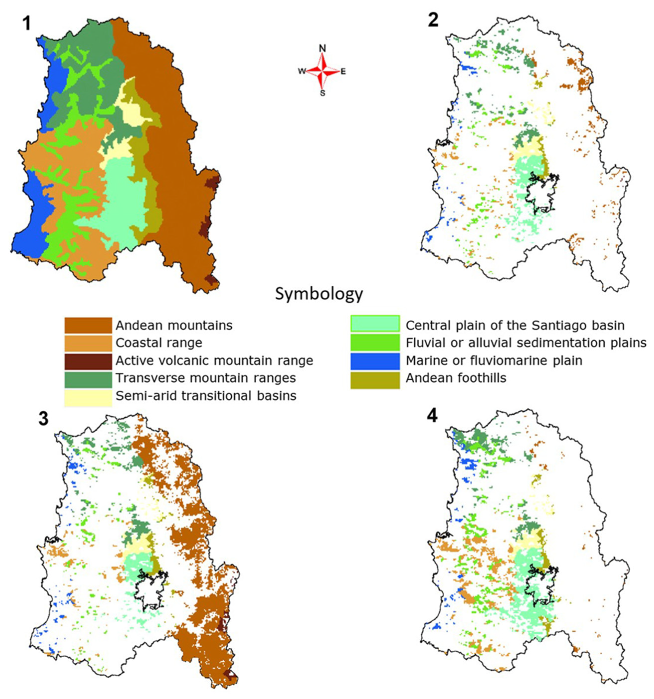
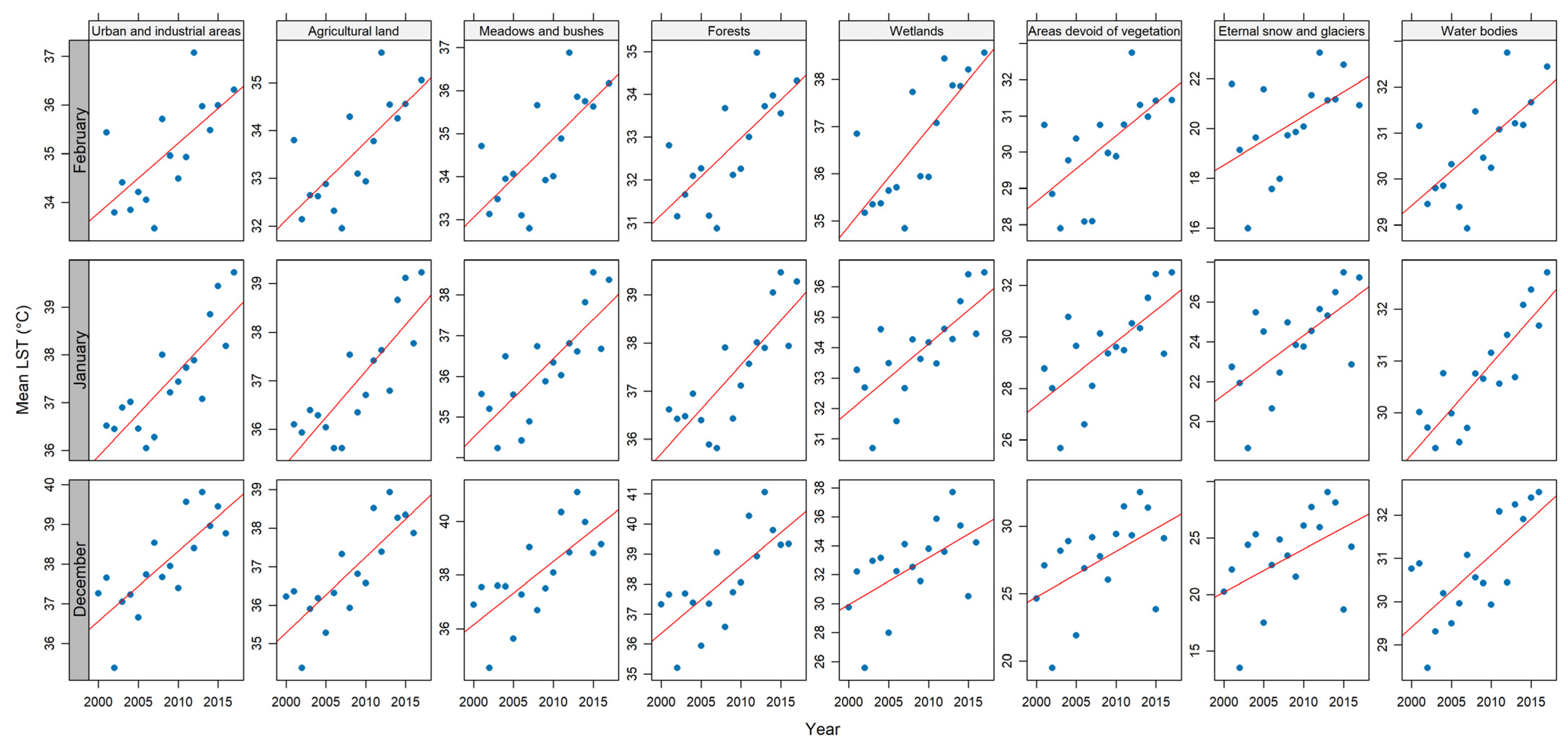
| Land Use | Total Area (km2) | December | January | February | |||
|---|---|---|---|---|---|---|---|
| Trend (°C year−1) | Area (km2) | Trend (°C year−1) | Area (km2) | Trend (°C year−1) | Area (km2) | ||
| Urban and industrial areas | 1911 | 0.176 | 368 | 0.178 | 292 | 0.158 | 650 |
| Agricultural land | 3899 | 0.196 | 710 | 0.192 | 686 | 0.170 | 1326 |
| Meadows and bushes | 9475 | 0.234 | 878 | 0.193 | 2259 | 0.188 | 1348 |
| Forests | 9281 | 0.223 | 767 | 0.181 | 1237 | 0.186 | 1842 |
| Wetlands | 221 | 0.320 | 19 | 0.222 | 113 | 0.202 | 10 |
| Areas devoid of vegetation | 4922 | 0.339 | 289 | 0.246 | 2759 | 0.198 | 106 |
| Eternal snow and glaciers | 1530 | 0.382 | 113 | 0.298 | 1018 | 0.231 | 23 |
| Water bodies | 128 | 0.166 | 20 | 0.175 | 33 | 0.157 | 35 |
| Total | 31,367 | 3163 | 8398 | 5339 | |||
| Geomorphology | December | January | February | |||
|---|---|---|---|---|---|---|
| Trend (°C year−1) | Area (km2) | Trend (°C year−1) | Area (km2) | Trend (°C year−1) | Area (km2) | |
| Andean mountains | 0.361 | 492 | 0.237 | 5240 | 0.183 | 117 |
| Coastal range | 0.199 | 213 | 0.195 | 344 | 0.187 | 1094 |
| Active volcanic mountain ranges | 0.251 | 7 | 0.291 | 151 | 0.297 | 1 |
| Transverse mountain ranges | 0.184 | 535 | 0.158 | 732 | 0.166 | 723 |
| Semi-arid transitional basins | 0.283 | 438 | 0.263 | 430 | 0.247 | 400 |
| Central plain of the Santiago basin | 0.192 | 957 | 0.196 | 698 | 0.169 | 1588 |
| Fluvial or alluvial sedimentation plains | 0.161 | 232 | 0.160 | 298 | 0.163 | 831 |
| Marine or fluviomarine plain | 0.192 | 91 | 0.170 | 162 | 0.186 | 277 |
| Andean foothills | 0.241 | 196 | 0.183 | 334 | 0.182 | 309 |
| Total area | 3162 | 8389 | 5339 | |||
Disclaimer/Publisher’s Note: The statements, opinions and data contained in all publications are solely those of the individual author(s) and contributor(s) and not of MDPI and/or the editor(s). MDPI and/or the editor(s) disclaim responsibility for any injury to people or property resulting from any ideas, methods, instructions or products referred to in the content. |
© 2024 by the authors. Licensee MDPI, Basel, Switzerland. This article is an open access article distributed under the terms and conditions of the Creative Commons Attribution (CC BY) license (https://creativecommons.org/licenses/by/4.0/).
Share and Cite
Muñoz-Aguayo, P.; Morales-Salinas, L.; Pizarro, R.; Ibáñez, A.; Sangüesa, C.; Fuentes-Jaque, G.; Toledo, C.; Garcia-Chevesich, P.A. Spatio-Temporal Behavior of Land Surface Temperatures (LSTs) in Central Chile, Using Terra MODIS Images. Hydrology 2024, 11, 103. https://doi.org/10.3390/hydrology11070103
Muñoz-Aguayo P, Morales-Salinas L, Pizarro R, Ibáñez A, Sangüesa C, Fuentes-Jaque G, Toledo C, Garcia-Chevesich PA. Spatio-Temporal Behavior of Land Surface Temperatures (LSTs) in Central Chile, Using Terra MODIS Images. Hydrology. 2024; 11(7):103. https://doi.org/10.3390/hydrology11070103
Chicago/Turabian StyleMuñoz-Aguayo, Pedro, Luis Morales-Salinas, Roberto Pizarro, Alfredo Ibáñez, Claudia Sangüesa, Guillermo Fuentes-Jaque, Cristóbal Toledo, and Pablo A. Garcia-Chevesich. 2024. "Spatio-Temporal Behavior of Land Surface Temperatures (LSTs) in Central Chile, Using Terra MODIS Images" Hydrology 11, no. 7: 103. https://doi.org/10.3390/hydrology11070103
APA StyleMuñoz-Aguayo, P., Morales-Salinas, L., Pizarro, R., Ibáñez, A., Sangüesa, C., Fuentes-Jaque, G., Toledo, C., & Garcia-Chevesich, P. A. (2024). Spatio-Temporal Behavior of Land Surface Temperatures (LSTs) in Central Chile, Using Terra MODIS Images. Hydrology, 11(7), 103. https://doi.org/10.3390/hydrology11070103


