Article

Suitability Assessment and Optimization of Small Dams and Reservoirs in Northern Ghana

by
Etienne Umukiza
1,2,
Felix K. Abagale
1,2,
Thomas Apusiga Adongo
1,3 and
Andrea Petroselli
4,*
1
West African Centre for Water, Irrigation and Sustainable Agriculture (WACWISA), University for Development Studies, Tamale P.O. Box TL 1882, Ghana
2
Department of Agricultural Engineering, University for Development Studies, Tamale P.O. Box TL 1882, Ghana
3
Department of Agricultural Mechanization and Irrigation Technology, University for Development Studies, Tamale P.O. Box TL 1882, Ghana
4
Department of Agriculture and Forest Sciences (DAFNE), Tuscia University, 01100 Viterbo, Italy
*
Author to whom correspondence should be addressed.
Hydrology 2024, 11(10), 166; https://doi.org/10.3390/hydrology11100166
Submission received: 21 August 2024 / Revised: 3 October 2024 / Accepted: 4 October 2024 / Published: 7 October 2024
(This article belongs to the Special Issue Hydrological Modeling and Sustainable Water Resources Management)

Abstract

:
Water shortages, exacerbated by erratic rainfall, climate change, and population growth, pose significant challenges globally, particularly in semi-arid regions like northern Ghana. Despite the construction of numerous small dams in the region that were intended to provide reliable water for domestic and irrigation purposes, critical water issues persist during dry periods. Key drivers in this failure are attributed to the lack of studies and/or the number of inadequate studies on suitable dam siting. This study focused on assessing the sites of selected small dams in northern Ghana, employing various methods such as stream order analysis and the Analytic Hierarchy Process within a Geographic Information System framework. Results showed that many existing dams are poorly sited, with over half located far from major stream networks, resulting in drying out during the dry season and failing to meet sustainable water storage standards. This study proposed new dam locations that would allow achieving a significant increase in storage capacities from 30% to 60%. These results highlight the necessity for decision-makers to adopt research-based approaches to address water shortages effectively, balancing agricultural, domestic, economic, and environmental needs. Future research should integrate climate change considerations, long-term monitoring, environmental impact assessments, and advanced decision-making techniques such as machine learning.

1. Introduction

Water plays an essential role in the survival of humans and the sustainability of communities. However, concerns about water scarcity are becoming more widespread, ex-acerbated by ongoing global climate change, particularly in Arid and Semi-Arid Lands (ASALs) [1]. Therefore, with the rapid population growth, and the development in in-dustry and agriculture, it is of great importance to mitigate water shortage with more effective ways to preserve water resources [2,3].
A study conducted by Faizal et al. [4] suggested that good planning of small dams could be a water source alternative. The water stored in these reservoirs serves multiple purposes, including supplementing rainfed agriculture, facilitating dry season irrigated agriculture, and ensuring a stable supply of water for domestic needs [5]. Moreover, small dams play a vital role in supporting communities in ASALs, mitigating water shortage and averting the decline of the water table [3].
However, ASALs in developing countries, especially in Africa, still confront severe water challenges where a significant portion of the manageable water resources is rainwater harvesting through small dams [6,7].
In these areas, limited and irregular precipitation accompanied with high evapotranspiration and evaporation affect the task of meeting the water requirements of both populations and ecosystems [8,9].
Encouraging small dam construction to tackle the challenges of water access in smallholder farming systems is a crucial need for effective agricultural and domestic water management [10,11]. Therefore, striking a balance among the conflicting needs of agriculture, domestic consumption, economic, and environmental sustainability in the face of water scarcity remains a focal point, shaping the trajectory of water management in ASALs [12].
Additionally, accurate information about the actual storage capacity and subsequent changes over time of these reservoirs is most required for effective and efficient water management.
The World Commission on Reservoirs (WCR) defines a small reservoir as a structure with a height of less than 15 m and a storage capacity ranging from 50,000 to 1 × 10⁶ m³. Moreover, Annor et al. [13] suggest that small reservoirs can also be defined based on surface area coverage (water storage systems greater than 1 hectare but less than 100 hectares). However, the volume of water stored in most reservoirs fluctuates over time due to factors such as siltation, seepage, evaporation, and the availability of rainfall. In most of the cases, dams are classified according to their use, their hydraulic design, or the materials in which they are constructed.
Northern Ghana is classified as an ASAL, and water-related challenges emerge as pivotal aspects of socioeconomic development [14,15]. Despite long-term investment in small dam construction [16], with the recent one village one dam (1V1D) policy, northern Ghana still faces chronic water scarcity affecting both agriculture and house needs [16,17,18]. However, many of these small dams were reported to be improperly sited and poorly built to store water during the dry season.
Selection of the most suitable site for dam construction is one of the most complex and controversial decisions in water allocation [2]. Locating suitable dam sites for effective management of water resources and addressing competing demands is a major problem for optimal construction of water-harvesting reservoirs [19,20].
Moreover, considering multidisciplinary complexities involved in dam construction and limited financial resource allocation in developing countries, an appropriate siting and optimal storage capacity are persistent critical issues for sustainable water storage [21,22].
However, nowadays there are improved tools and advancements in geospatial technologies and machine learning techniques to create dam site suitability maps with limited effort [23]. The integration of Geographic Information System (GIS) and Remote Sensing (RS) can result in accurate site selection, and time and cost savings [24]. Therefore, strategic interventions are meticulously required in assessing dam siting where water scarcity presents formidable barriers to sustainable development, agricultural productivity, and overall societal well-being [9,25].
From the existing literature, there are several approaches that have been used for dam site selection, such as statistical, rational method, GIS Multicriteria Decision Analysis (MCDA) [26], integrating GIS and Analytical Hierarchical Process (AHP) [2,3,27,28], GIS-AHP and weighted overlay analysis [3,28], AHP and fuzzy logic [29], and AHP and machine learning [23,30,31]. Moreover, AHP, as decision-making was extensively used in the site for dam construction [20,21].
According to Jozaghi et al. [32], AHP was seen as a powerful tool in dam site selection due to its ability to handle complex, multi-criterion decisions in a structured and transparent manner. The benefit of AHP is that it allows a hierarchical structure of the criteria that enables users to have a better focus on specific criteria and subcriteria when assigning the weights [33]. As a technique to analyse complex situations and make sound decisions, the AHP method has gained increasing attention for assessing and allocating weights and priorities in many domains.
AHP offers a structured and systematic approach to selecting a suitable dam location by integrating various criteria and managing subjective judgement. However, it also faces challenges related to subjectivity, computational complexity, and consistency. Therefore, balancing these aspects is crucial for leveraging AHP effectively in dam site selection.
RS and GIS are crucial for water resource management. While RS is applied in the collection of vital data for mapping water resource management and hydrological fluxes, GIS serves as a key tool for effective water resource including model setup and data analysis [34,35,36]. These studies were carried out on relatively large study regions with different numbers of physical, climatic, and hydrological criteria.
From the existing literature, GIS-based AHP has been used in several studies for the selection of suitable sites for dam construction [3,23,37,38]. However, this approach has not been employed in a relatively small drainage area, with little variation in topography and environmental conditions of constructed small dams in northern Ghana, to alleviate water issues, harness optimal catchment yield, and sustainable water availability. Therefore, in perspective of addressing water shortage issues in northern Ghana, this study aimed to assess the suitability of small dams constructed in the region, and advance the field by assessing the suitability of existing small dams using GIS-based MCDM, AHP, and RS.
In addition, this study proposed optimal storage capacities by integrating spatial data and Civil 3D. Therefore, understanding the shapes and accuracy of the dam sites in consideration of the drainage basin and functions of watersheds will give planners important information to reverse water scarcity for sustainable water source development. While this study primarily focuses on technical and environmental considerations, it is important to acknowledge that the economic benefits and costs of constructing small dams also play a crucial role in determining dam siting.

2. Materials and Methods

2.1. Study Area

This study encompassed 16 existing small dams and reservoirs across northern Ghana (4 northern regions), as shown in Figure 1. The geographic description and specific details of the study areas are listed in Table 1. Geographically, Ghana is situated between latitudes 4°30′ N and 11° N and longitudes 1° E and 3°30′ W, sharing borders with Togo, Ivory Coast, and Burkina Faso to the east, west, and north, respectively.
Northern Ghana is one of the driest regions of the country due to its proximity to the Sahara Desert and the Sahel region [39]. This part of the country experiences rainfall marked by seasonality and annual variability. Generally, the principal feature of rainfall in northern Ghana is its seasonal character and its variability from year to year.
The rainfall pattern is unimodal, covering the period from June to September with a mean annual rainfall of approximately 950 mm, followed by long dry periods from November to March, and dry and dusty harmattan winds.
The climate is tropical, characterized by high temperatures with an average annual temperature of 30 °C [7]. Vegetation is predominantly Savannah woodlands dominated by draught-resistant trees and grasses with scattered trees and shrubs.
Despite the region facing water shortage issues, it is known for its agricultural pursuits, with farming serving as a primary occupation and a key economic activity.

2.2. Data Used

The Digital Elevation Model (DEM) of the Shuttle Radar Topographic Mission (SRTM) raster format, with a resolution of 30 m, was gathered from Google Explorer 2023 off the United States Geological Survey’s Earth Explorer (USGS) site (http://earthexplorer.usgs.gov/, accessed on 22 February 2023). From the DEM, the slope and stream layers were processed and clipped for each catchment through delineation of the whole watershed and sub-basin using ArcMap 10.7.1.
Land cover data were downloaded from Landsat 8 satellite images accessed in March 2023 (with 30 m resolution) and enhanced by onsite inspection. The data on hydrologic soil groups (HSG), according the USDA classification, were collected from the NASA website’s global hydrologic soil group dataset (https://daac.ornl.gov/SOILS/guides/Global_Hydrologic_Soil_Group.html, accessed in March 2024) in raster format and clipped in each of the catchments accordingly.

2.3. Weather Data

Weather data, such as rainfall and temperature data for each catchment under study, was collected from the Modern-Era Retrospective Analysis for Research and Applications, Version 2 (MERRA-2) [40] product of NASA POWER. It incorporates observational data from various sources to create a comprehensive and accurate representation of the Earth’s climate over a specific period.
Since the catchments of our study were ungauged and no meteorological weather was available, we used MERRA-2 data acquired using coordinates of each catchment to perform precipitation and temperature analyses. MERRA-2 was reanalyzed in the study conducted by Rodrigues and Braga [41], to estimate daily weather variables in a hot summer Mediterranean climate; the study found good agreement between MERRA-2 data and observed data for all parameters except wind speed.
Also, comparison between daily values from MERRA-2 and meteorological stations using several statistical tools were in acceptable agreement [42]. The study conducted by Ngurah et al. [43] on the island of Bali using observed rainfall from several locations and MERRA-2 rainfall data found high correlation values. In places rainfall data are not available, as it is a case of our catchments, rainfall from MERRA-2 can be utilized as a credible source.
MERRA-2 is a reliable source for global meteorological data (precipitation, maximum and minimum temperature, humidity, and solar radiation) when compared with observed data [44]. In addition, considering climate changes, it is important to consider how future climate conditions may affect water availability. For instance, rising temperatures are likely to enhance evaporation (E) and evapotranspiration (ET) rates, which could further exacerbate water stress.
Therefore, temperature and precipitation projections from Global Climate Models (GCMs), such as those from the Coupled Model Intercomparison Project Phase 6 (CMIP6), provide valuable insights into how future climate conditions may evolve. These models simulate the Earth’s climate under different Representative Concentration Pathways (RCPs) and Shared Socioeconomic Pathways (SSPs) 4.5 and 8.5 emission scenarios, which represent potential future greenhouse gas concentration trajectories.

2.4. Data Processing

The geographical position of current dams/reservoirs was acquired from sites and localized within the downloaded SRTM DEM. Each catchment was delineated with the help of an assemble of Arc Hydro and a hydrology tool watershed modelling approach in a GIS environment [45]. The stream order was defined and extracted for each catchment concerning the closeness of maximal flow accumulation while the elevations and slope from DEM were organized into four classes.
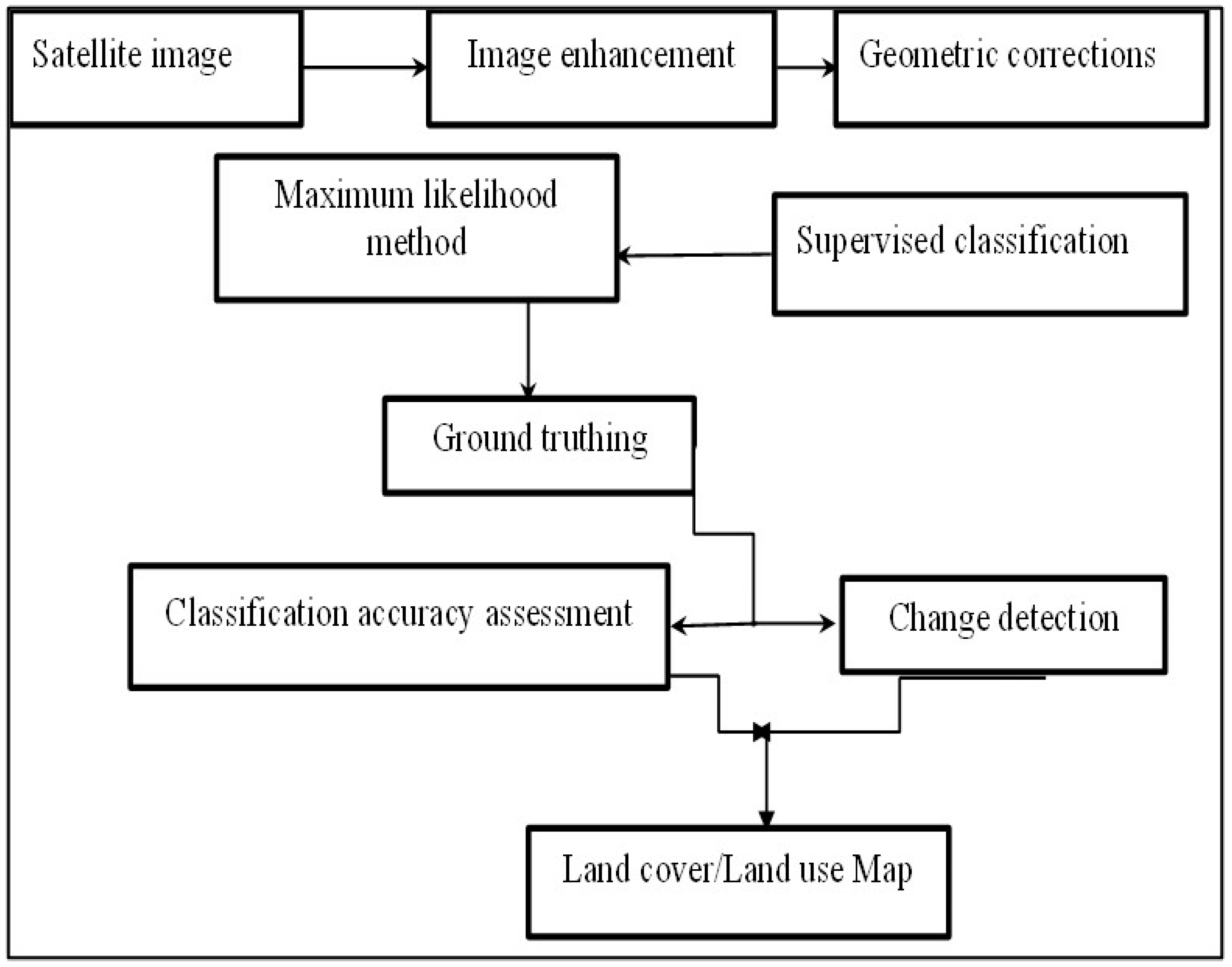
Land Use/Land Cover (LULC) maps were prepared using a supervised classification approach using ERDAS Imagine 2015 (Figure 2). LULC directly influences the Curve Number (CN), an important parameter, ranging from 0 to 100, used to predict direct runoff or retention, with a high CN indicating high surface runoff [7], circumstance that suggests that the area has low natural storage capacity and high runoff potential, hence indicating a low suitability for locating dam sites. The CN depends on the soil type, the effect of LULC, and the hydrogeological condition.
To identify the most pertinent factors for the suitable location of dams and reservoirs, an investigation of the literature, consultation of local community and representatives of water users were conducted. In addition, organized consultations were undertaken in the form of interviews with experts in various backgrounds such as geology, water resource engineering, civil engineering, and hydrologists.
The experts provided key insights; for instance, geologists emphasized the need for impermeable geological formations to ensure dam stability; hydrologists highlighted catchment characteristics and rainfall patterns for adequate water inflow; engineers focused on technical feasibility, considering construction costs and proximity to infrastructure; all experts stressed the importance of balancing environmental impacts and community needs.
Therefore, each criterion was classified based on the existing literature and experts’ opinion and judgement [46,47]. The Analytic Hierarchy Process (AHP) method was consequently used as a weighting method for GIS-based Multicriteria Decision-Making (MCDM) to determine the site suitability for small dams/reservoirs [2,22,40,41,42,43,44,45,46,47].
The systematic steps on identification and selection of criteria for siting small dams/reservoirs, data acquisition and pre-processing, pairwise comparison matrix, and overlay analysis were undertaken.
Correspondingly, after acquiring and pre-processing all data, they were all converted into raster format and rescaled in the same spatial resolution of 30 m using the World Geodetic System (WGS) 84 and the Universe Transverse Mercator (UTM) 30N coordinate system.
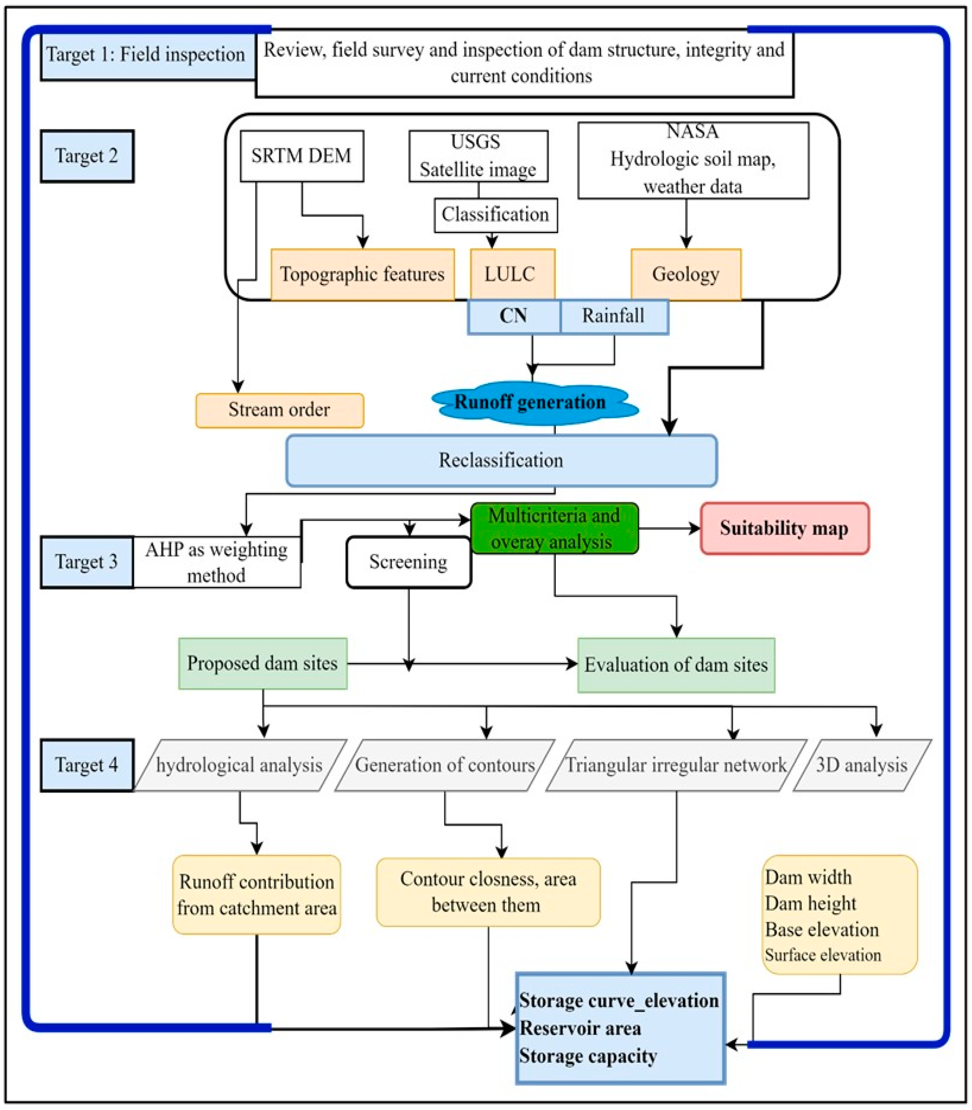
Finally, from the proposed sites for small dams/reservoirs, the suitability assessment was performed, and their optimal storage capacity was assessed (Figure 3).

2.5. Reclassification, Analytical Hierarchy Process (AHP) Analysis, and Overlay Analysis

Reclassification was implemented using the reclassification tool in ArcGIS. Raster layers were reclassified into four classes, except for geological, which was divided into two potential categories based on professional judgement in geology, water resource management, and civil engineering.
In addition, an extensive review of the existing literature was consulted [21,22,48,49,50,51,52]. The AHP process was developed by Saaty [53,54], as a useful technique for handling complex decision-making.
During the decision-making process, this strategy assists decision-makers in prioritizing options, subcriteria, and criteria in order to arrive at the optimal choice. Therefore, a pair-wise comparison matrix (AHP) in alignment with experts’ judgement was used to evaluate criteria weight. During the analysis of potential dam sites, the parameters summarized in Table 2 were considered.
The implementation of AHP involved the application of the MCDM preference matrix and the determination of the parameters’ weight for site suitability analysis [49]. The pairwise comparison was applied to all criteria (Table 3).
After the pairwise comparison matrix was performed, the normalized weighted matrix was calculated according to a relative level of importance [29]. Furthermore, a consistency ratio (CR) was computed from the normalized vector values to ensure the reliability and consistency of judgements, see Equation (1) [52]:
C R = C I R I
where CR is the consistency ratio, CI is the consistency index, and RI represents the standard value, reported in Table 4.
Consistency index results from sample-produced joint matrices. If the CR < 0.10, it means that the pairwise matrix has an acceptable consistency [51]. Otherwise, it has inadequate consistency, and the comparison process must be repeated [3]. Therefore, CI was given by Equation (2) [30]:
C I = λ n n 1
where λ m a x is the number of factors being compared to the matrix, and λ is the highest eigen value of the pairwise comparison matrix.
According to [49], the maximum eigen value of the comparison matrix can be calculated using the following method:
(i)
Multiplying each value in the column (in the matrix table which is not normalized) by criteria weight.
(ii)
Computing the weighted sum value by adding the values in the rows.
(iii)
Calculating the ratio of each weighted sum value to the respective criteria weight.
(iv)
Averaging the ratio of weighted sum value to the criteria weight.
After performing the weights and reclassification of all criteria, the weighted overlay analysis was performed in ArcGIS Spatial Analyst using a weighted overlay technique, producing suitability maps with a spatial resolution of 30 m × 30 m.

2.6. Suitability Assessment Potential Zones for Suitable Dam Siting

Identification of potential sites for water storage was analyzed within the dam’s catchments, far away (more than 100 m) from the current dam location. As aforementioned, the AHP method was employed for site suitability assessment through overlay analysis, facilitating the identification of a suitable dam location, by considering the surrounding area and overlaying of layers such as slope, elevation, LULC, drainage density, and geology.
The pairwise weighs each element against each other, where each level is related to reality from the ground morphology, knowledge from the literature and experts’ opinions [20]. Additional analysis picked the surrounding area by considering the overlaying of layers such as slope, elevation, LULC, and geology.

2.7. Evaluation of Current and Proposed Dam Sites Storage Capacities

Further analysis was conducted for six catchments named Dinaso Boo, Denegu, Busona, Sambu, Duago, and Kepersii. After the potential dam site locations were investigated, six proposed new dam locations underwent evaluation of optimal storage capacity including a thorough analysis to ascertain the viability and appropriateness of possible dam construction sites.
This procedure took into account several variables, such as 3D surface analysis, 2D surface area topographical features, dam height, catchment area, water flow patterns, hydrological, and maximum volume to guarantee the dam’s long-term sustainability and structural integrity.
Contours were generated with an interval of 2.5 m from the DEM. Civil 3D software, the Spatial Analyst tool, was added as an extension to the Arc toolbox and the 3D analyst tool was used to determine the storage capacities and represent the elevation, storage capacity, and elevation submerged under different areas respectively.
Mathematically, the incremental volume between any contour elevations and live capacity of a reservoir can be calculated using Equations (3)–(5):
V i = h A I + A i + 1 + A A I + 1 1 3
V I = k = 1 i V k
Y a = i = 1 N 1 V i
where ∆Vi is the volume between contour elevations i and i + 1, ∆h is the contour interval, Ai is the area at contour elevation I, Ai + 1 is the area at contour elevation 1 + i, Ya is the live capacity of reservoir, and N is the number of contour elevations.
After analyzing each dam/reservoir area in both 2D and 3D representations, two options of optimal storage were identified. Option 1 highlighted the maximum storage capacity, while Option 2 showcased the alternative potential storage based on ground morphology and on catchment characteristics.

3. Results and Discussion

3.1. Suitability Assessment and Stream Network Maps

The first stage of suitability assessment drove an understanding of the appropriateness of the dams’ placement concerning the natural hydrological features of the landscape. This stage of the study focused on evaluating the alignment of the current dams’ locations with the available stream networks within each catchment.
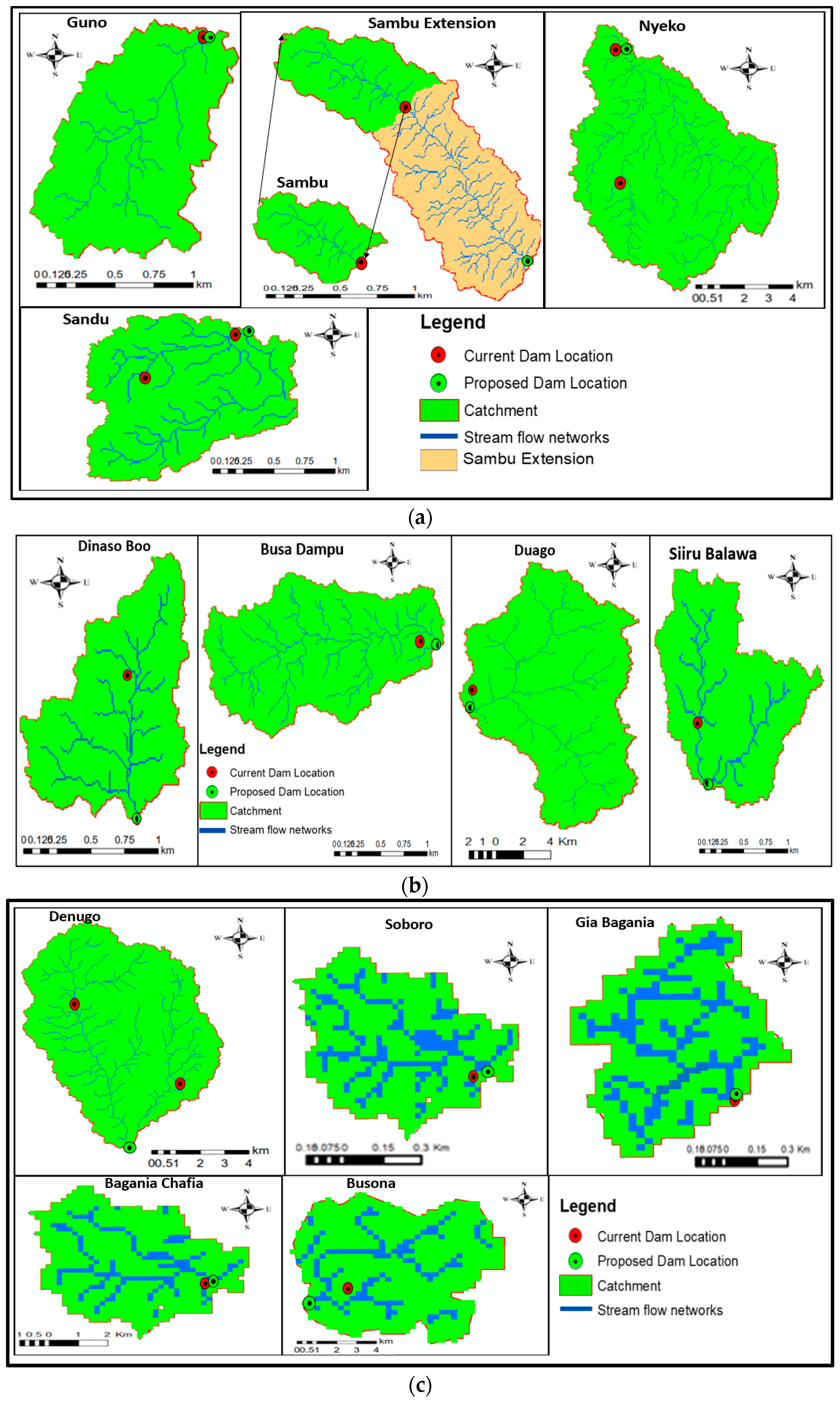
After each catchment was analyzed in terms of the current dam’s location compared to the main stream network, the results from the stream network versus current dams’ location showed that Guno, Nyeko, and Sandu current dams were located within a reasonable distance (less than 100 m) away from a major stream network, suggesting that they are well located in considered catchments. However, Sambu sub-catchment was suggested as a possible extension to further downstream the dam location to maximize the potential runoff harvesting.
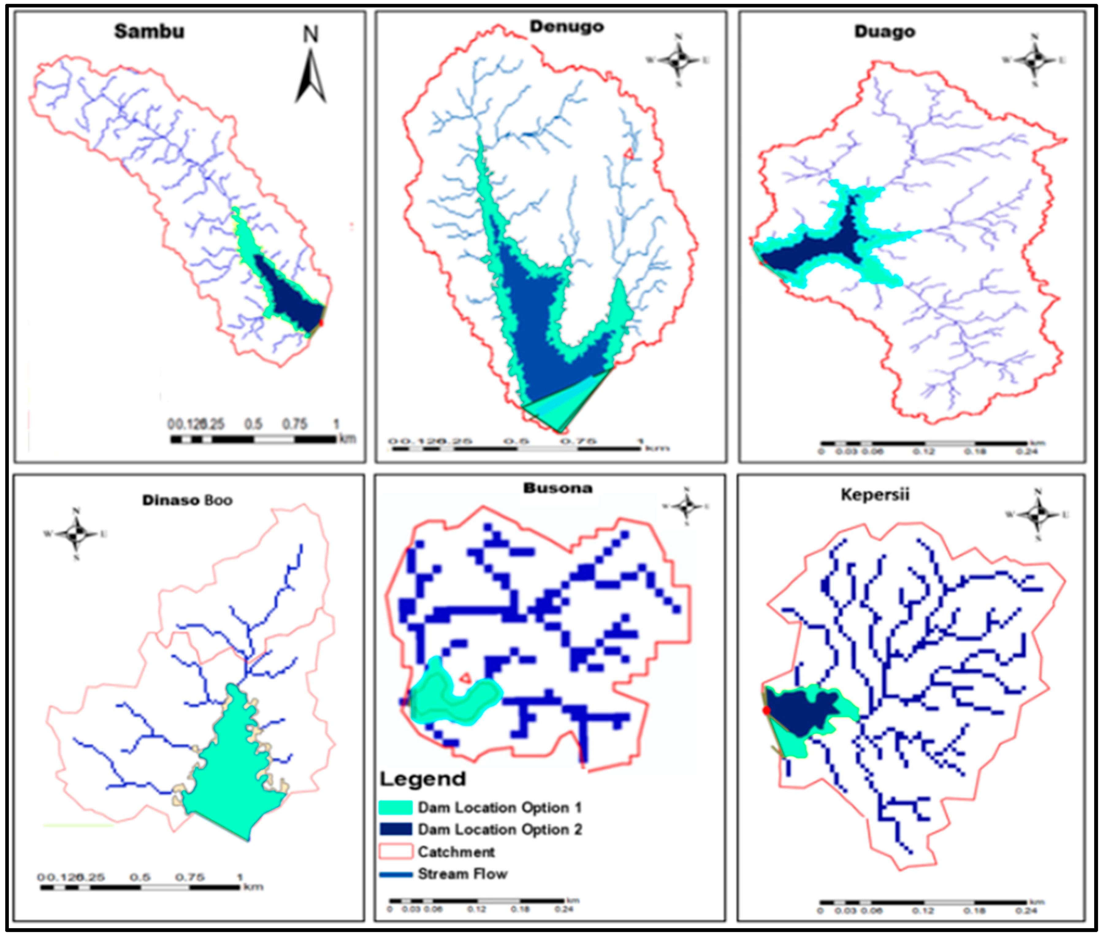
In the Upper West region, Busa Dambu and Siiru/Balawa were found to be well located (less than 100 m) to collect the runoff from the catchment, based on the stream flow networks analysis. However, based on the findings of Figure 4, additional dam locations were suggested by expanding the catchment area in Dinaso Boo, Duago, and Kepersii sub-catchments.
In the Upper East region, the analysis suggested that Busona, Gia Bagania, and Gia Bagania (1V1D) were located within the suitable location considering the distance separating the major stream networks and current dam locations. Nevertheless, the Denugo sub-catchment was suggested as an additional location of dam with possibility to expand the catchment area for potential maximum runoff yield.
Most of the investigated dam sites were properly chosen. The outcome of the analysis across the studied catchments in Northern Regions of Ghana, where current dam locations were analyzed versus stream networks within the catchment is presented for the Northern Region, Upper East, and Upper West, in Figure 4a–c, respectively.
In general, the outcome of the analysis showed that among the 16 analyzed catchments, 10 were in reasonable distance (less than 100 m) to major stream networks and, consequently, judged relatively well located. However, for six of them (Kepersii, Sambu, Duago, Denugo, Dinaso, and Busona) a potential suitable relocation was proposed to maximize the catchment runoff yield.
In the pursuit of sustainable water resource management, it is indeed imperative to ensure that dams are strategically located to optimize their functionality and minimize environmental impact. After analyzing each catchment, the results from the first part of this study show the assessed suitable sites based on stream network prevail in the respective catchments with the existing dam locations.
Figure 4a–c highlight disparities in dam placement across the studied catchments. Some dams exhibit a considerable distance (more than 100 m) away from the available stream network, indicating potential challenges in harnessing the full hydrological potential of the catchment. However, other dams were found to be strategically positioned at reasonable distances from tributaries, suggesting a more judicious selection in their locations.

3.2. Dam Sites Suitability Maps

The AHP method was used for site suitability assessment through overlay analysis and design of their optimal storage capacities. The pairwise weighed each element against each other (Table 5), where each level was related to reality from the ground morphology, knowledge from the literature, and experts’ opinions.
The normalized matrix was established by dividing each entity’s parameters by the sum of all from their respective column. According to our study, stream networks were given the highest importance while DEM and Geology were attributed equal value to moderate values, while the slope was attributed a lower value based on its insignificance from the ground nature (flat areas).
Thus, the weight used in overlay for each criterion was calculated from an average of each raw multiplied by 100 (Table 6): (Average of the normalized matrix) × 100. With λ max equal to 5.18, the resulting consistency ratio was acceptable (0.04) [28,48]. Moreover, a CR exceeding 10% is not reliable. Otherwise, the iteration starts again unless the result is less than 0.1.
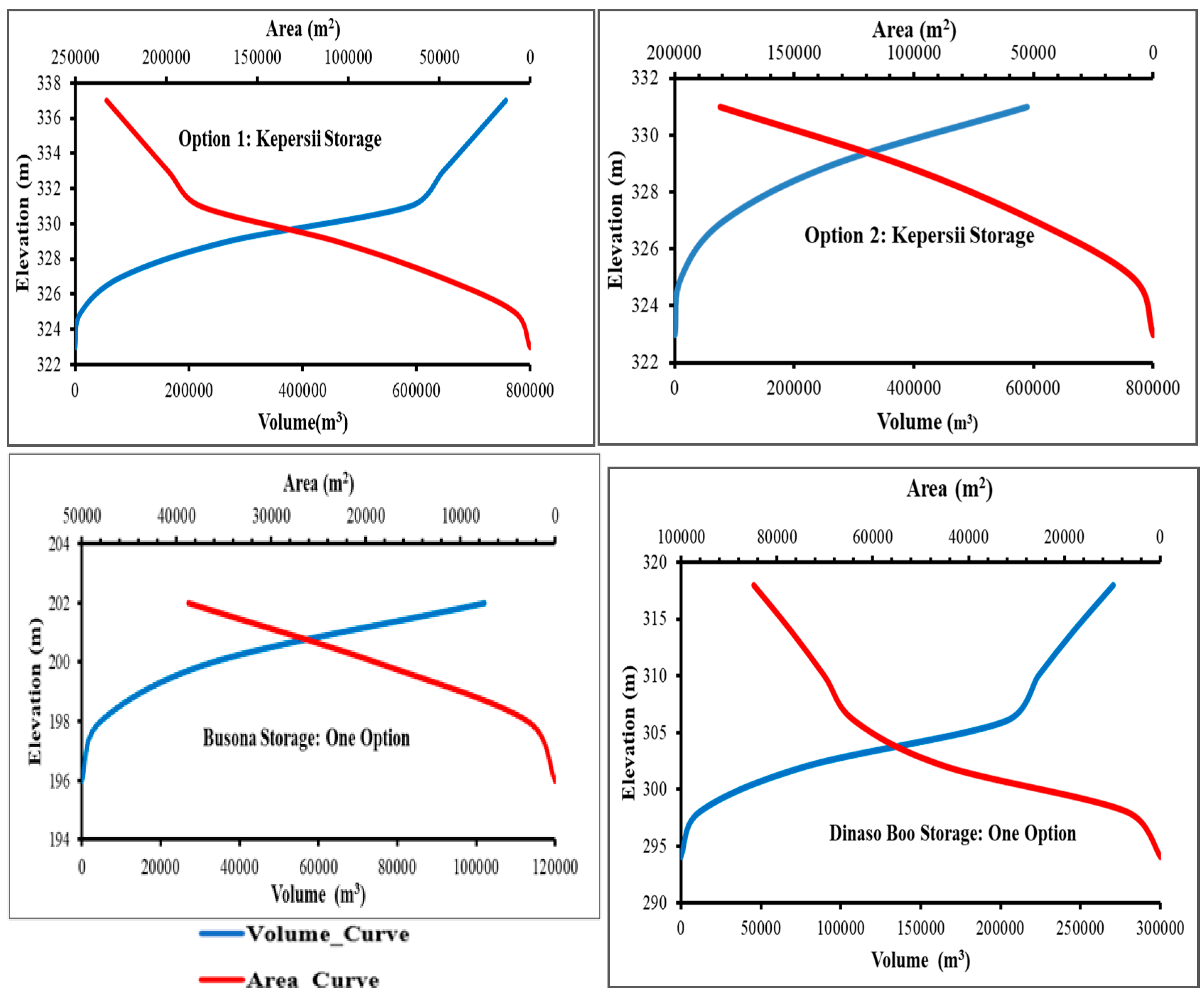
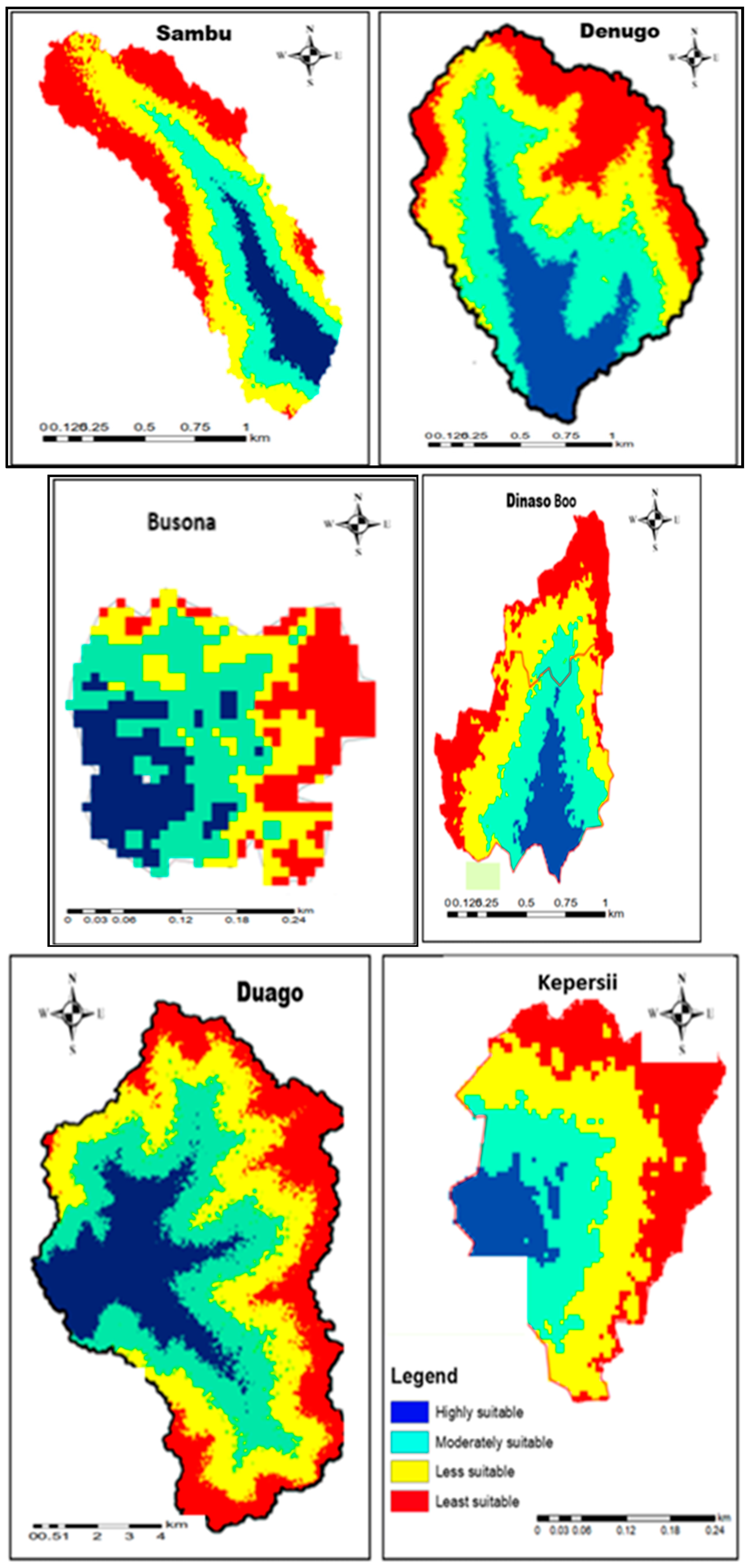
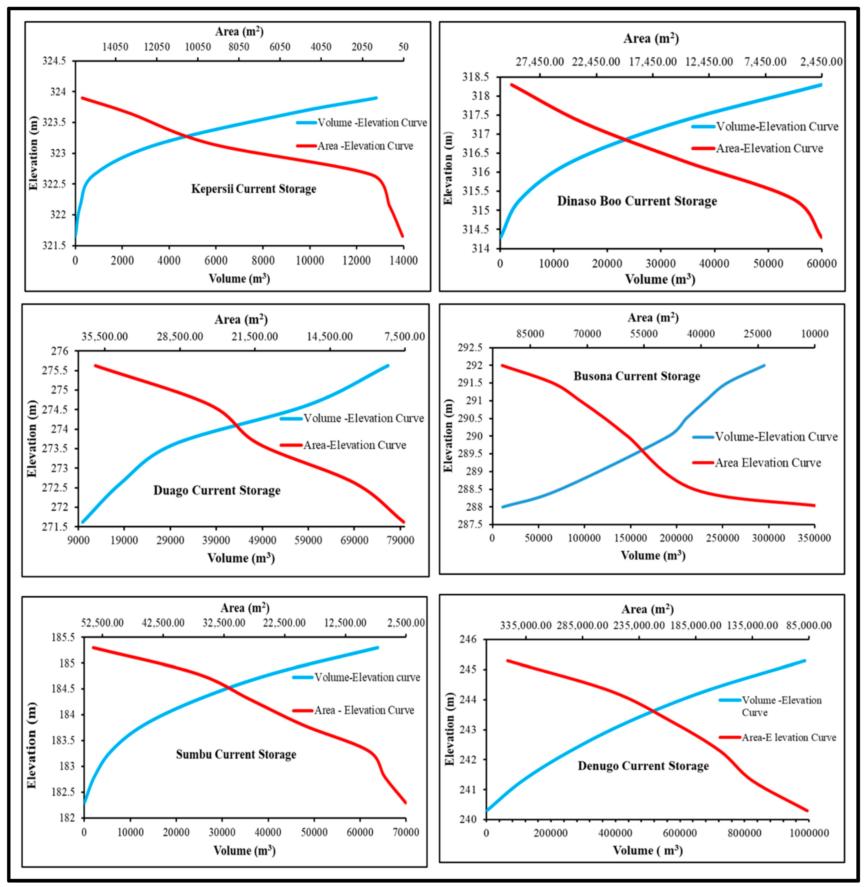
The overlay analysis was operated by agreeing with all criteria layers to perform suitability maps based on superimposition activities in ArcGIS. In combination with other parameters, higher to less suitable areas of the six catchments analyzed in detail are displayed in Figure 5. Moreover, Figure 6 delineates various storage stages in volume and corresponding area, corresponding to different elevations.
The results show possible options for increasing water harnessing to attenuate the water shortage and reverse the effects of climate change. Regarding dam planning, construction, and optimization, this visual analysis sets the stage for a detailed examination of each catchment’s unique characteristics, as reported in the next paragraph.

3.3. Evaluation of Storage Capacities of Existing Dams

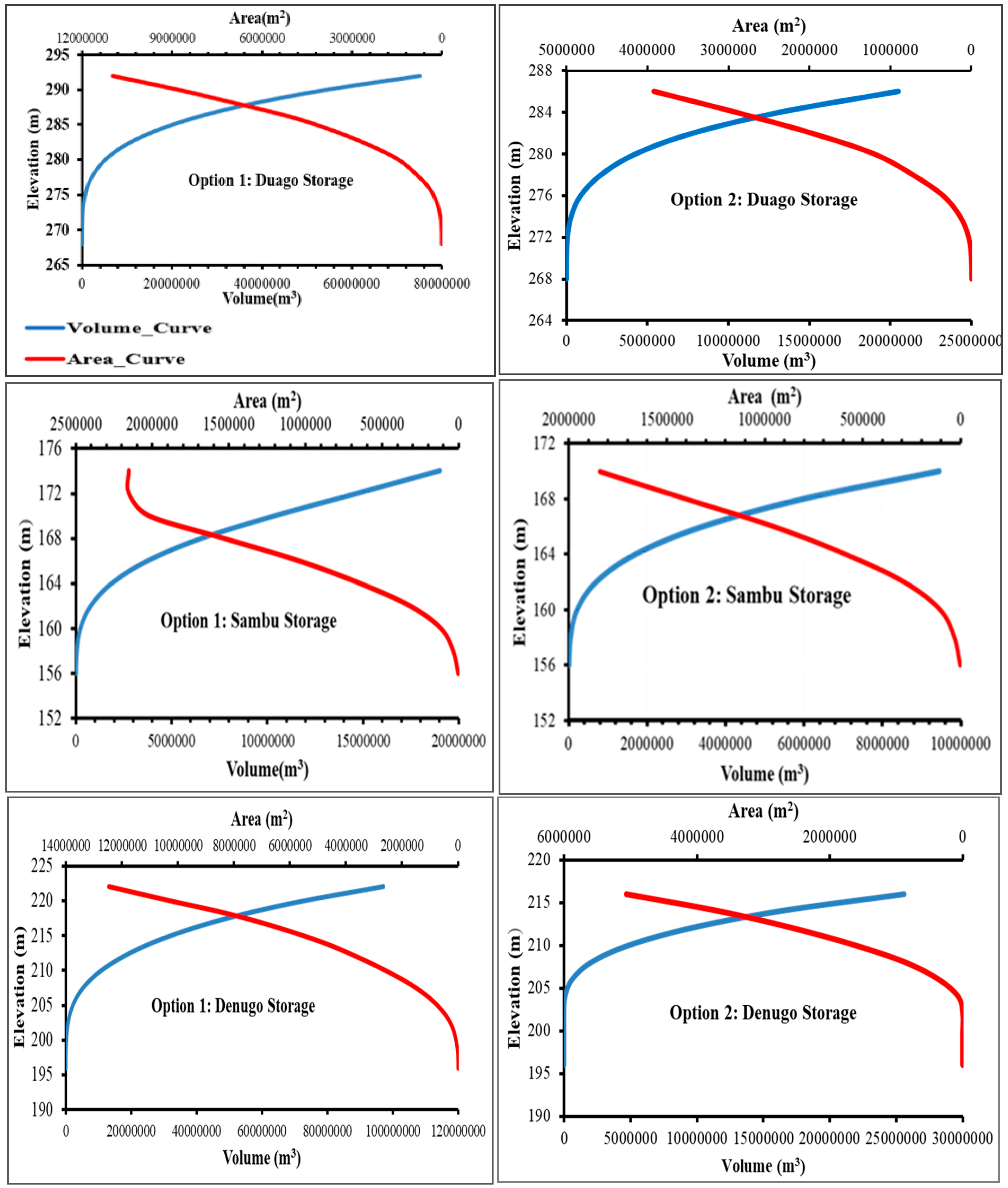
The results of current reservoirs’ storage capacities are presented in Figure 7 for existing reservoirs, and Appendix A for the proposed ones (Options 1 and 2). The elevation–area and elevation–volume curves provided graphical representations of elevation stages and corresponding surface area and volume of water stored.
For each catchment, there was a discernible correlation between elevation and the resulting variations in reservoir area and volume.
The curves provided a comprehensive overview of the optimal storage capacity for the proposed dam sites under two distinct options, except for Dinaso Boo and Busona which were proposed options based on ground features.
The data provide valuable insights into the optimal storage capacity under each option, showcasing the dynamic changes in area and volume as the elevation varies. After a general analysis of the respective proposed relocation of the small dam/reservoir, optimal elevation area–storage curves displayed different storage capacities and corresponding areas and elevations for each.
The estimated storage capacities of different dam options were compared. It was found that the storage capacity of Option 1 for the Duago Dam was 20% greater than that of Option 2, and Option 1 offered a 40% increase in storage capacity compared to the dam’s current capacity. Option 1 for the Sambu Dam showed an increase of 80% in storage capacity over the suggested capacity in Option 2, and a 40% increase over the reservoir’s present capacity. Option 2 for the Denugo Dam showed a 50% increase over the current storage and a 25% increase over Option 1 in terms of area and volume. Option 1 for the Kepersii dam proposed a 60% increase in storage capacity over the current storage in the watershed and 30% increase in volume over Option 2.
The comparison between these options allows for a nuanced understanding of the potential storage variations based on ground morphology and elevation changes. In addition, the implementation of gauging stations and soil loss records in the watershed is highly necessary to monitor direct sediment and erosion measurement before dam construction. Understanding these relationships is crucial for informed decision-making in stored water usage and planning.

4. Discussion

From existing academic literature, the subjects of selecting suitable locations for small dams in ASAL regions of northern Ghana received little attention.
Given the important expectations and investments being made on dams, it was necessary to assess and ascertain the safety of the small dams and their reservoirs. Safety inspections were carried out on all critical sections of the structural and non-structural defects, and engineering characteristics.
The assessment of reservoir condition, upstream, downstream embankment, and spillway revealed good, fair and lack of maintenance, poor, and very poor conditions. Generally, the results from onsite inspections highlight the importance of maintenance in each of the inspected dams.
While cost and resource constraints are indeed important factors in decision-making for small dam construction, strategic and important factors such as environmental, hydrological conditions, and long-term sustainability should equally be considered through research.
In this regard, this study includes a multicriteria consideration approach that makes use of state-of-the-art models to identify the best sites for dam construction in the investigated region. The process of selecting a dam site was here influenced by various factors, necessitating the application of multicriteria decision-making techniques to address this complexity.
Following the initial screening utilizing stream networks to identify potential dam sites, based on stream order and hydrological distance from streams, the outcome shows the differences between the current small dam/reservoir to the mainstream flow. These findings suggest that the decision to construct some dams/reservoirs may not have considered critical factors of suitable dam siting. This was attributed to the lack of consideration of some suitability factors identified in this study.
The application of the AHP method across the investigated catchments found that six small reservoirs were not located on the mainstream, and revealed distinct suitable locations in different levels as highly suitable, moderately suitable, less suitable, and least suitable. The method provides a potent and adaptable tool for resolving issues involving multiple criteria, to assess and identify an optimal location for constructing a small earth dam within diverse catchments [49,50].
Moreover, the study by Karakuş and Yıldız [3] employed GIS-based multicriteria evaluation, considering factors like land use, slope, soil type, and proximity to water bodies. The AHP method was applied to evaluate dam sites based on environmental and socioeconomic criteria [3,27,31]. The integration of diverse criteria in the current study aligns with this approach but is distinguished by the detailed use of AHP for specific hydrological factors and also adds novelty by incorporating detailed elevation area–storage curves, offering a more dynamic analysis of storage capacities.
Nevertheless, in regions prone to water scarcity, where increasing agricultural water demand is a significant driver, the inclusion of various stakeholders is critical when implementing water resource management strategies [56,57]. This emphasizes the broader benefits of comprehensive and well-planned water resource management.
The study by Apollonio et al. [58], reported that improper water management in the Asso Torrent basin, Italy, highlights the risks of relying on outdated water management paradigms that fail to adapt to changing environmental conditions. The study revealed how the discharge of treated wastewater into channels intended to recharge a groundwater system led to increased flooding and damage due to insufficient infrastructure and the growing frequency of intense rainfall events.
This case underscores the necessity of moving away from traditional, centralized water management approaches and adopting more adaptive strategies.
Additionally, the study determined the optimal storage capacity under each option, showcasing detailed understanding of dynamic changes in elevation area–storage curves. The combination of elevation area–storage curves provides a comprehensive understanding of dynamic changes in reservoir capacity. These storage curves not only facilitate better understanding but also serve as a vital reference for reservoir management, flood control in case of occurrence, and water resource planning [59].
The comparison between these options allows for a nuanced understanding of the potential storage variations based on ground morphology and elevation changes. With climate uncertainty and the vulnerability of water resources often termed by hypsometric factors, the developed options of reservoir operations can allow decision-makers to address both water supply demand and the implication of the effects of climate change, and this is in agreement with the study by [60].
Therefore, the presented options for storage capacity hold significant implications for decision-makers involved in dam site selection and reservoir planning. In addition, it is essential to consider the practical applications of the collected water for agricultural, domestic, and other purposes. The potential for agricultural water uses in northern Ghana is significant, particularly in supporting small-scale irrigation systems that could improve local food security.
Domestic water use could provide critical benefits for rural communities by enhancing access to reliable water sources, which remains a challenge in many areas. In the context of climate uncertainty and rising demand, optimizing water use for both agriculture and domestic needs will be key to ensuring the sustainability of these dams and reservoirs.
Moreover, these findings emphasize the understanding of the estimation of area-storage capacities using a Triangular Irregular Network (TIN) model in the ArcMap at appreciable costs, as reported by Fuska et al. [59], compared to existing techniques that require labour-intensive, time-consuming, and cost implication [60]. Also the study by Sawunyama et al. [61] conducted on the estimation of the small reservoir storage capacities, emphasized the significance and the linear correlation from data collected from the field using GIS and remote sensing.
The presentation of storage options empowers policy makers to make informed choices that balance environmental, economic, and social considerations contributing to the overall success and sustainability of the dam project.

5. Conclusions

This study aimed to address pressing water shortages for domestic use and irrigation purposes in ASALs of northern Ghana, where constructed small dams face issues harnessing optimal catchment yield. The process of selecting a dam site was influenced by various factors, necessitating the application of multicriteria decision-making techniques to address this complexity.
The initial screening utilized stream networks to ascertain and identify potential dam locations based on stream order and hydrological distance, identifying six dams (Kepersii, Sambu, Duago, Denugo, Dinaso, and Busona) situated more than 100 m from mainstream flows.
The application of the AHP to these six small reservoirs identified varying levels of suitability: highly suitable, moderately suitable, less suitable, and least suitable. The highly suitable zones were noted for their potential to yield water effectively, considering the valley shape for dam wall construction, high stream density, and contributing catchment area. Furthermore, optimal elevation area–storage curves for the existing and proposed locations demonstrated different storage capacities and corresponding areas, offering a comprehensive understanding of optimal storage, water management, and allocation.
The findings underscore the usefulness of AHP as a versatile tool for resolving multicriteria issues, essential for optimal dam site selection. By identifying highly suitable zones, this study provides a foundation for improved water resource management, particularly in semi-arid areas facing climate change challenges.
This study highlights the critical role of multicriteria decision-making techniques, particularly AHP, in optimizing dam site selection to enhance water resource management in semi-arid regions.
By addressing both technical and managerial aspects, the research offers a pathway to sustainable water harvesting, crucial for adapting to climate change and meeting domestic and agricultural water demands. This can aid policymakers and water resource managers in making informed decisions about water allocation, drought management, and infrastructure design, ultimately enhancing water harvesting and sustainability in the region.
However, this study acknowledges some limitations, including the exclusion of some environmental criteria in the site selection process and the lack of assessment of socioeconomic impacts. Additionally, this study did not engage with the community to track the long-term performance and structural integrity of the small dams and reservoirs.
Even though it would have been ideal to have more onsite experts to potentially contribute more relevant knowledge about the failure cause of small dams/ reservoirs in the study area, this study had to be carried out with the specialists we could identify from different locations.
In addition to hydrological factors, non-hydrological parameters also play a critical role in dam site selection. These include land tenure and ownership, which can affect the ease of land acquisition and community acceptance; accessibility to infrastructure, which influences construction and maintenance costs; ecological impact, especially the potential for disrupting local ecosystems and biodiversity; and socioeconomic factors, such as the population’s reliance on the land for agriculture or settlement.
The inclusion of such factors ensures that dam site selection is not only technically viable but also socially acceptable and environmentally sustainable. Incorporating these broader considerations helps ensure that dam projects are integrated into the local context, minimizing conflicts and maximizing benefits.
Therefore, future research should incorporate a broader range of environmental criteria for dam site selection and assess the socioeconomic impacts of small dams and reservoirs. Engaging with the community to monitor the performance and structural integrity of these water resources over time will provide valuable insights.
Moreover, to give the results more validity, future iterations of this study could consider including a variability and confidence analysis regarding the extent of the participants’ knowledge of each site.
It is also advised to carry out fieldwork for community consultation in order to ascertain the population’s perspective regarding the construction of the dams/reservoirs in the suggested locations in order for the process to be deemed community property. These efforts will help to refine site selection methods and enhance the sustainable management of water resources in similar contexts.

Author Contributions

Conceptualization, E.U.; methodology, E.U.; investigation, E.U.; writing original draft preparation E.U.; visualization and editing, A.P.; supervision, F.K.A. and T.A.A.; project administration and funding acquisition, F.K.A. All authors have read and agreed to the published version of the manuscript.

Funding

This publication was made possible through support provided by the West African Centre for Water, Irrigation and Sustainable Agriculture (WACWISA), University for Development Studies, Ghana with funding support from the Government of Ghana and The World Bank through the African Centres of Excellence for Development Impact (ACE Impact) initiative with Grant No. IDA Credit 6389.

Data Availability Statement

The data presented in this study are available on request from the corresponding author.

Conflicts of Interest

The authors declare no conflicts of interest.

Appendix A. Elevation–Storage Curve and Elevation–Area Curve for the Proposed Reservoirs
Hydrology 11 00166 g0a1aHydrology 11 00166 g0a1b

References

  1. Umukiza, E.; Abagale, F.K.; Adongo, T.A. A Review on Significance and Failure Causes of Small-Scale Irrigation Dams in Arid and Semi-arid Lands. J. Infrastruct. Plan. Eng. (JIPE) 2023, 2, 1–9. [Google Scholar] [CrossRef]
  2. Tata, H.; Lateef, L.; Nzelibe, I.U. Optimizing Mini Dam Placement for Sustainable Water Management in FUTA: A GIS-MCDA Approach. Turk. J. Remote Sens. GIS 2024, 5, 41–53. [Google Scholar] [CrossRef]
  3. Karakuş, C.B.; Yıldız, S. Gis-multi criteria decision analysis-based land suitability assessment for dam site selection. Int. J. Environ. Sci. Technol. 2023, 19, 12561–12580. [Google Scholar] [CrossRef]
  4. Faizal, T.A.; Pandjaitan, N.H.; Rau, M.I. Small dam planning as a water sources alternative in Sekaran Village, Bojonegoro Regency, Indonesia. IOP Conf. Ser. Earth Environ. Sci. 2021, 871, 012044. [Google Scholar] [CrossRef]
  5. Liebe, J.; Andreini, M.; van de Giesen, N.; Steenhuis, T. The Small Reservoirs Project: Research to Improve Water Availability and Economic Development in Rural Semi-arid Areas. In The Hydropolitics of Africa: A Contemporary Challenge; Cambridge Scholars Publishing: Newcastle upon Tyne, UK, 2015. [Google Scholar]
  6. Umukiza, E.; Ntole, R.; Chikavumbwa, S.R.; Bwambale, E.; Sibale, D.; Jeremaih, Z.; Apollonio, C.; Petroselli, A. Rainwater harvesting in arid and semi-arid lands of africa: Challenges and opportunities. Acta Sci. Pol. Form. Circumiectus 2023, 22, 41–52. [Google Scholar] [CrossRef]
  7. Umukiza, E.; Abagale, F.K.; Adongo, T.A. Characterization of landuse and landcover dynamics and their impact on runoff generation patterns in dam catchments of Northern Ghana. Geocarto Int. 2024, 39, 2335247. [Google Scholar] [CrossRef]
  8. Ahmed, A.O.C.; Nagasawa, R.; Hattori, K.; Chongo, D.; Perveen, M.F. Analytical hierarchic process in conjunction with GIS for identification of suitable sites for water harvesting in the Oasis areas: Case study of the Oasis zone of Adrar, Northern Mauritania. J. Appl. Sci. 2007, 7, 2911–2917. [Google Scholar] [CrossRef]
  9. Awuah, E.; Gyasi, S.F.; Anipa, H.M.K.; Sekyiamah, K.E. Assessment of rainwater harvesting as a supplement to domestic water supply: Case study in Kotei-Ghana. Int. Res. J. Public Environ. Health 2014, 1, 126–131. Available online: https://journalissues.org/irjpeh/abstract/gyasi-et-al/ (accessed on 1 March 2024).
  10. Blanc, E.; Strobl, E. Is small better? A comparison of the effect of large and small dams on cropland productivity in South Africa. World Bank Econ. Rev. 2014, 28, 545–576. [Google Scholar] [CrossRef]
  11. Henrique Pinto, W.L.; Canno Ferreira Fais, L.M. The Small Dams Safety Index (SDSI): A tool for small dams safety assessment. Int. J. River Basin Manag. 2022, 21, 551–558. [Google Scholar] [CrossRef]
  12. Hamze, Y. Water Conservation in Arid Countries, Small Friendly Environmental Lakes and Dams, Research Study of a Small-Scale Experimental Dam Project on a Small River. SciFed J. Glob. Warm. 2020, 1. [Google Scholar] [CrossRef]
  13. Annor, F.O.; Van De Giesen, N.; Liebe, J.; Van De Zaag, P.; Tilmant, A.; Odai, S.N. Delineation of small reservoirs using radar imagery in a semi-arid environment: A case study in the upper east region of Ghana. Phys. Chem. Earth 2009, 34, 309–315. [Google Scholar] [CrossRef]
  14. Damman, S.; Helness, H.; Amisigo, B.; Banu, R.A.R.A.; Asante, K.A.; Bjørkvoll, T.; Akuffobea, K.A.M.; Logah, F.; Williams, P.A.; Mensah, F.A.M.F.A.; et al. Sustainability and the Social Construction of Technology: The Case of Rwh As Source of Water Supply in Greater Accra. Eur. J. Sustain. Dev. 2017, 6, 41–52. [Google Scholar] [CrossRef]
  15. Akuffobea-Essilfie, M.; Williams, P.A.; Asare, R.; Damman, S.; Essegbey, G.O. Promoting rainwater harvesting for improving water security: Analysis of drivers and barriers in Ghana. Afr. J. Sci. Technol. Innov. Dev. 2020, 12, 443–451. [Google Scholar] [CrossRef]
  16. Darko, D.; Kpessa-Whyte, M.; Obuobie, E.; Siakwah, P.; Torto, T.; Tsikata, D. The Context and Politics of Decision Making on Large Dams in Ghana: An Overview; Future-DAMS Working Paper 002; The University of Manchester: Manchester, UK, 2009. [Google Scholar]
  17. Adongo, T.A.; Kyei-baffour, N.; Abagale, F.K.; Wilson, A. Lake and Reservoir Management Assessment of reservoir sedimentation of irrigation dams in northern Ghana. Lake Reserv. Manag. 2020, 36, 87–105. [Google Scholar] [CrossRef]
  18. Glitse, P.; Nyamadi, B.V.; Mintah, K.A.; Feruta-Benee, C. Small Scale Irrigation in Ghana: Challenges and Prospects in the Face of Climate Variability. Int. J. Irrig. Agric. Dev. (IJIRAD) 2018, 2, 133–143. [Google Scholar] [CrossRef]
  19. Kharazi, P.; Arab khazaeli, E.; Heshmatpour, A. Delineation of suitable sites for groundwater dams in the semi-arid environment in the northeast of Iran using GIS-based decision-making method. Groundw. Sustain. Dev. 2021, 15, 100657. [Google Scholar] [CrossRef]
  20. Dortaj, A.; Maghsoudy, S.; Ardejani, F.D.; Eskandari, Z. A hybrid multi-criteria decision making method for site selection of subsurface dams in semi-arid region of Iran. Groundw. Sustain. Dev. 2020, 10, 100284. [Google Scholar] [CrossRef]
  21. Dai, X. Dam Site Selection Using an Integrated Method of AHP and GIS for Decision Making Support in Bortala, Northwest China. Master’s Thesis, Lund University, Lund, Sweden, 2016. [Google Scholar]
  22. Minatour, Y.; Khazaei, J. Extension of an integrated AHP and TOPSIS approach in water resources management. In Proceedings of the 9th International River Engineering Conference, Shahid Chamran University, Ahwaz, Iran, 22–24 January 2013. [Google Scholar]
  23. Al-kakey, O.; Othman, A.A.; Al-mukhtar, M.; Dunger, V. Proposing Optimal Locations for Runoff Harvesting and Water Management Structures in the Hami Qeshan Watershed, Iraq. ISPRS Int. J. Geo-Inf. 2023, 12, 312. [Google Scholar] [CrossRef]
  24. Al-ruzouq, R.; Shanableh, A.; Merabtene, T.; Siddique, M. Catena Potential groundwater zone mapping based on geo-hydrological considerations and multi-criteria spatial analysis: North UAE. Catena 2019, 173, 511–524. [Google Scholar] [CrossRef]
  25. USAID and Sustainable Water Partnership (SWP). Senegal Water Resources Profile. Water Resour. Profile Ser. 2021, 1–10. [Online]. Available online: https://www.globalwaters.org/resources/assets/senegal-water-resources-profile (accessed on 1 April 2024).
  26. Abushandi, E.; Alatawi, S. Dam Site Selection Using Remote Sensing Techniques and Geographical Information System to Control Flood Events in Tabuk City. Hydrol. Curr. Res. 2015, 6, 189. [Google Scholar] [CrossRef]
  27. Zewdie, M.M.; Tesfa, C. GIS-based MCDM modeling for suitable dam site identification at Yeda watershed, Ethiopia. Arab. J. Geosci. 2023, 16, 369. [Google Scholar] [CrossRef]
  28. Minatour, Y.; Khazaei, J.; Ataei, M.; Javadi, A.A. An integrated decision support system for dam site selection. Sci. Iran. 2015, 22, 319–330. [Google Scholar]
  29. Luís, A.d.A.; Cabral, P. Small dams/reservoirs site location analysis in a semi-arid region of Mozambique. Int. Soil Water Conserv. Res. 2021, 9, 381–393. [Google Scholar] [CrossRef]
  30. Noori, A.M.; Pradhan, B.; Ajaj, Q.M. Dam site suitability assessment at the Greater Zab River in northern Iraq using remote sensing data and GIS. J. Hydrol. 2019, 574, 964–979. [Google Scholar] [CrossRef]
  31. Al-Ruzouq, R.; Shanableh, A.; Yilmaz, A.G.; Idris, A.; Mukherjee, S.; Khalil, M.A.; Gibril, M.B.A. Dam site suitability mapping and analysis using an integrated GIS and machine learning approach. Water 2019, 11, 1880. [Google Scholar] [CrossRef]
  32. Jozaghi, A.; Alizadeh, B.; Hatami, M.; Flood, I.; Khorrami, M.; Khodaei, N.; Tousi, E.G. A comparative study of the AHP and TOPSIS techniques for dam site selection using GIS: A case study of Sistan and Baluchestan Province, Iran. Geosciences 2018, 8, 494. [Google Scholar] [CrossRef]
  33. Ouma, Y.O.; Tateishi, R. Urban Flood Vulnerability and Risk Mapping Using Integrated Multi-Parametric AHP and GIS: Methodological Overview and Case Study Assessment. Water 2014, 6, 1515–1545. [Google Scholar] [CrossRef]
  34. Masud, M.J.; Bastiaanssen, W.G. Remote Sensing and GIS Applications in Water Resources Management. Water Resour. Manag. 2017, Chapter 16, 351–373. [Google Scholar]
  35. Kumar, H.; Singh, K. Water Resourse: Role of GIS and Remote Sensing. Int. J. Eng. Res. Technol. 2018, 6, 11–13. [Google Scholar]
  36. Angelidis, P.; Kotsikas, M.; Kotsovinos, N. Management of Upstream Dams and Flood Protection of the Transboundary River Evros/Maritza. Water Resour. Manag. 2010, 24, 2467–2484. [Google Scholar] [CrossRef]
  37. Doost, Z.H.; Yaseen, Z.M. Allocation of reservoirs sites for runoff management towards sustainable water resources: Case study of Harirud River Basin, Afghanistan. J. Hydrol. 2024, 634, 131042. [Google Scholar] [CrossRef]
  38. Yang, W.; Jin, F.; Si, Y.; Li, Z. Runoff change controlled by combined effects of multiple environmental factors in a headwater catchment with cold and arid climate in northwest China. Sci. Total Environ. 2021, 756, 143995. [Google Scholar] [CrossRef] [PubMed]
  39. Ampim, P.A.Y.; Ogbe, M.; Obeng, E.; Akley, E.K.; Maccarthy, D.S. Land cover changes in ghana over the past 24 years. Sustainability 2021, 13, 4951. [Google Scholar] [CrossRef]
  40. Gelaro, R.; McCarty, W.; Suárez, M.J.; Todling, R.; Molod, A.; Takacs, L.; Randles, C.A.; Darmenov, A.; Bosilovich, M.G.; Reichle, R.; et al. The modern-era retrospective analysis for research and applications, version 2 (MERRA-2). J. Clim. 2017, 30, 5419–5454. [Google Scholar] [CrossRef]
  41. Rodrigues, G.C.; Braga, R.P. Evaluation of nasa power reanalysis products to estimate daily weather variables in a hot summer mediterranean climate. Agronomy 2021, 11, 1207. [Google Scholar] [CrossRef]
  42. Marzouk, O.A. Assessment of global warming in Al Buraimi, sultanate of Oman based on statistical analysis of NASA POWER data over 39 years, and testing the reliability of NASA POWER against meteorological measurements. Heliyon 2021, 7, e06625. [Google Scholar] [CrossRef]
  43. Ngurah, G.; Dharmayasa, P.; Simatupang, C.A.; Sinaga, D.M. NASA Power’s: An alternative rainfall data resources for hydrology research and planning activities in Bali Island, Indonesia. J. Infrastruct. Plan. Eng. (JIPE) 2022, 1, 1–7. [Google Scholar] [CrossRef]
  44. Bandira, P.N.A.; Tan, M.L.; Teh, S.Y.; Samat, N.; Shaharudin, S.M.; Mahamud, M.A.; Tangang, F.; Juneng, L.; Chung, J.X.; Samsudin, M.S. Optimal Solar Farm Site Selection in the George Town Conurbation Using GIS-Based Multi-Criteria Decision Making (MCDM) and NASA POWER Data. Atmosphere 2022, 13, 2105. [Google Scholar] [CrossRef]
  45. Khan, A.; Richards, K.S.; Parker, G.T.; Mcrobie, A.; Mukhopadhyay, B. How large is the Upper Indus Basin? The pitfalls of auto-delineation using DEMs. J. Hydrol. 2014, 509, 442–453. [Google Scholar] [CrossRef]
  46. Singh, P.; Gupta, A.; Singh, M. Hydrological inferences from watershed analysis for water resource management using remote sensing and GIS techniques. Egypt. J. Remote Sens. Space Sci. 2014, 17, 111–121. [Google Scholar] [CrossRef]
  47. Raj, N.J.; Prabhakaran, A.; Muthukrishnan, A. Quantitative stream network analysis for assessing form and hydrological processes of the watersheds of Kolli hills, Tamil Nadu, India. Arab. J. Geosci. 2021, 14, 2646. [Google Scholar] [CrossRef]
  48. Chandio, I.A.; Matori, A.-N.; Lawal, D.U.; Sabri, S. GIS- based Land Suitability Analysis Using AHP for Public Parks Planning in Larkana City. Mod. Appl. Sci. 2011, 5, 177. [Google Scholar] [CrossRef]
  49. Yasser, M.; Jahangir, K.; Mohmmad, A. Study in the west of Iran Earth dam site selection using the analytic hierarchy process (AHP): A case study in the west of Iran. Arab. J. Geosci. 2012, 6, 3417–3426. [Google Scholar] [CrossRef]
  50. Estoque, R.C. Analytic Hierarchy Process in Geospatial Analysis. In Progress in Geospatial Analysis; Springer: Tokyo, Japan, 2012. [Google Scholar] [CrossRef]
  51. Staudinger, M.; Stoelzle, M.; Seeger, S.; Seibert, J.; Weiler, M.; Stahl, K. Catchment water storage variation with elevation. Hydrol. Process. 2017, 31, 2000–2015. [Google Scholar] [CrossRef]
  52. Shin, E.C.; Kim, D.H.; Lee, J.K.; Kang, J.K. Assessment of the Engineering Conditions of Small Dams Using the Analytical Hierarchy Process. Iran. J. Sci. Technol. Trans. Civ. Eng. 2021, 45, 1297–1305. [Google Scholar] [CrossRef]
  53. Saaty, T.L. Decision making with the analytic hierarchy process. Int. J. Serv. Sci. 2008, 1, 83–98. [Google Scholar] [CrossRef]
  54. Saaty, T.L. Analytic Hierarchy Process. In Encyclopedia of Biostatistics; John Wiley & Sons, Ltd.: Hoboken, NJ, USA, 2005. [Google Scholar] [CrossRef]
  55. Chezgi, J. Application of SWAT and MCDM Models for Identifying and Ranking Suitable Sites for Subsurface Dams. In Spatial Modeling in GIS and R for Earth and Environmental Sciences; Elsevier Inc.: Amsterdam, The Netherlands, 2019. [Google Scholar] [CrossRef]
  56. Saaty, T.L. Axiomatization of the Analytic Hierarchy Process. In Decision Making with Multiple Objectives: Proceedings of the Sixth International Conference on Multiple-Criteria Decision Making, Held at the Case Western Reserve University, Cleveland, Ohio, USA, June 4–8, 1984; Springer: Berlin/Heidelberg, Germany, 1985. [Google Scholar] [CrossRef]
  57. Giordano, R.; Milella, P.; Portoghese, I.; Vurro, M.; Apollonio, C.; D’Agostino, D.; Lamaddalena, N.; Scardigno, A.; Piccinni, A. An innovative monitoring system for sustainable management of groundwater resources: Objectives, stakeholder acceptability and implementation strategy. In Proceedings of the 2010 IEEE Workshop on Environmental Energy and Structural Monitoring Systems, Taranto, Italy, 9 September 2010; pp. 32–37. [Google Scholar] [CrossRef]
  58. Apollonio, C.; Rose, M.D.; Fidelibus, C.; Orlanducci, L.; Spasiano, D. Water management problems in a karst flood-prone endorheic basin. Environ. Earth Sci. 2018, 77, 676. [Google Scholar] [CrossRef]
  59. Fuska, J.; Kubinský, D.; Weis, K.; Lackóová, L.; Pokrývková, J.; Leitmanová, M.; Panagopoulos, T. Area-storage capacity curve of historic artificial water reservoir ottergrund, Slovakia-Assessment of the historical data with the use of GIS tools. J. Ecol. Eng. 2017, 18, 49–57. [Google Scholar] [CrossRef]
  60. Liebe, J.; van de Giesen, N.; Andreini, M. Estimation of small reservoir storage capacities in a semi-arid environment. Phys. Chem. Earth 2005, 30, 448–454. [Google Scholar] [CrossRef]
  61. Sawunyama, T.; Senzanje, A.; Mhizha, A. Estimation of small reservoir storage capacities in Limpopo River Basin using geographical information systems (GIS) and remotely sensed surface areas: Case of Mzingwane catchment. Phys. Chem. Earth 2006, 31, 935–943. [Google Scholar] [CrossRef]
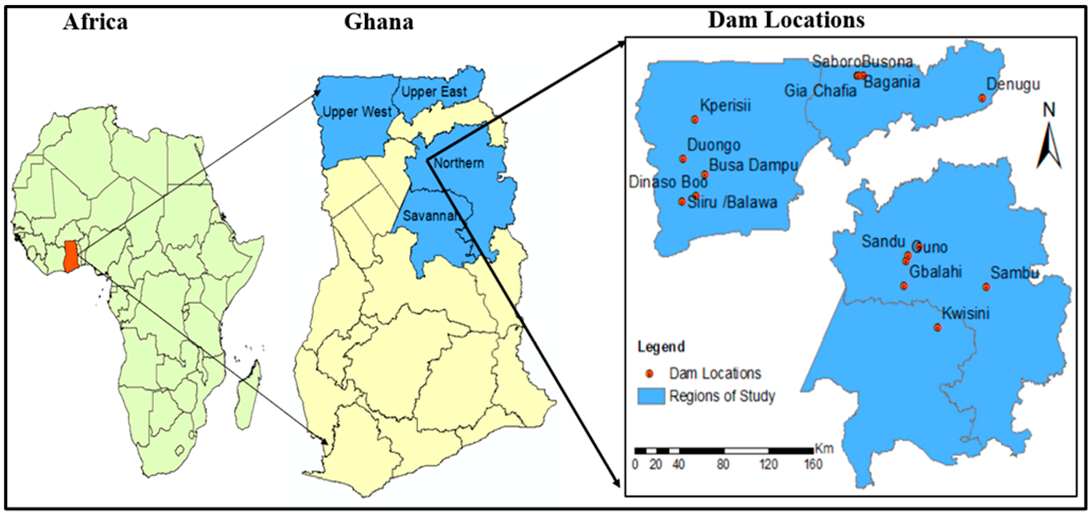
Figure 1. Map of Ghana showing the study regions and dams.
Hydrology 11 00166 g001
Figure 2. LULC analysis flowchart for the study.
Hydrology 11 00166 g002
Figure 3. Flowchart of research methodology of the study.
Hydrology 11 00166 g003
Figure 4. (a) Suitability maps based on stream networks on selected dam catchments in the Northen Region. (b) Suitability maps based on stream networks on selected dam catchments in the Upper West Region. (c) Suitability maps based on stream networks on selected dam catchments in the Upper East Region.
Hydrology 11 00166 g004
Figure 5. Suitability levels for dam sites in the catchment.
Hydrology 11 00166 g005
Figure 6. Proposed dam location and options of storage stages: Option 1 highlights the maximum storage capacity. Option 2 showcases the alternative potential storage.
Hydrology 11 00166 g006
Figure 7. Storage stages for the existing reservoirs.
Hydrology 11 00166 g007
Table 1. Geographic description, coordinates referenced in the World Geodetic System 1984 (WGS84), and specific details of the study areas.
NumberCatchment NamesArea (km2)Latitude
(Degree)
Longitude
(Degree)
Year of
Construction
DistrictsRegions
1Gbalahi110.009.426522−0.7613702019Tamale MetropolitanNorthern
2Guno29.59.599071−0.7483592021NantonNorthern
3Sambu38.509.421129−0.1059682019MionNorthern
4Sandu10.569.643587−0.7304332020NantonNorthern
5Nyeko120.659.79261−0.657291980KaragaNorthern
6Denugu67.8110.761581−0.1359972020GaruUpper East
7Saboro0.9610.917569−1.0933462019Kasena-Nankana MunicipalUpper East
8Busona0.7810.915739−1.142381979Kasena Nankana MunicipalUpper East
9Gia Bagania Chafia0.5610.91510−1.1414021990Kasena Nankana MunicipalUpper East
10Gia Bagania0.5410.914675−1.1306962019Kasena Nankana MunicipalUpper East
11Duongo106.0410.326808−2.5448801980Nadowli-KaleoUpper West
12Keperisii3.4310.907583−2.445812021Wa MunicipalUpper West
13Siiru/Balawa4.4610.021704−2.5533141988Wa MunicipalUpper West
14Dinaso Boo8.7010.063607−2.4440802021Wa MunicipalUpper West
15Busa Dampu38.4010.215136−2.3698041990Wa EastUpper West
16Kwisini02.599.127211−0.4934002020North East GonjaSavannah
Table 2. Reclassified layers and their preference value of suitability.
ClassesPreference ValueSuitability
1st order0 Restricted
2nd order1 Not suitable
Stream order3rd order3 Modestly Suitable
4th order5 Highly Suitable
>250 Restricted
20–251 Not suitable
Land Slope13–203 Modestly Suitable
<65 Highly suitable
Built-Up Restricted
Agriculture0 Not suitable
Land Cover Forest1 Less
Water body 5 Highly suitable
Barren Land3 Moderately suitable
Elevation------ ---
Stream density------ ---
Note (---): preference depends on specific catchment.
Table 3. Pairwise scale of relative importance: source [3,29].
Intensity of Relative ImportanceDefinitionDescription
1Equal importanceTwo criteria contribute equally to the objective
3Moderate importanceExperience and judgment slightly favor one criterion over another
5Strong importanceExperience and judgement strongly favor one criterion over another
7Very strongA criterion is favored very strongly over another
9Extreme importanceThe evidence favoring one criterion over another is the highest possible order of affirmation
Table 4. Consistency indices for randomly generated matrix (RI) values: adapted from [55].
n12345678910
RI000.580.91.121.241.321.411.451.49
Table 5. Preference matrix, pairwise matrix with intensity judgements.
CriteriaStreamDEMLULCGeologySlope
Stream 13234
DEM1/31235
LULC1/21/2123
Geology1/31/31/212
Slope 1/41/51/31/21
Sum 2.4165.0335.8339.515
Table 6. Normalized matrix.
CriteriaStreamDEMLULCGeologySlopeWeight
Stream0.4130.5960.3420.3160.26739
DEM0.1380.1990.3420.3160.33327
LULC0.2060.0990.1710.2100.218
Geology0.1380.0660.0860.1050.13310
Slope0.1130.0930.0560.0520.0676
Disclaimer/Publisher’s Note: The statements, opinions and data contained in all publications are solely those of the individual author(s) and contributor(s) and not of MDPI and/or the editor(s). MDPI and/or the editor(s) disclaim responsibility for any injury to people or property resulting from any ideas, methods, instructions or products referred to in the content.