Abstract
The detection and mapping of riverscapes with Unmanned Aerial Vehicles (UAVs, drones) provide detailed, reliable, and operable spatial information in hydrological sciences, enhancing conventional field survey techniques. In this study, we present the results of long-term, optical RGB (red, green, blue) UAV monitoring of stream restoration projects to identify the positive and negative features that affect their sustainability. We determined quantitative and qualitative aspects of restoration, such as the restoration effect, the dynamics of fluvial processes, hydrological connectivity, and riparian vegetation. The study was based on six years of UAV monitoring in three restored streams in Prague, Czech Republic. The multitemporal riverscape models from the photogrammetric reconstruction served as a basis for the visual assessment, compliant with the standard hydromorphological assessment. Such a combined approach extends the potential of UAV monitoring by allowing for the use of existing classification schemes and data and the objective detection of critical features. The study pointed to the significant discrepancies in channel geometry between the planned restorations and realized restorations in all assessed projects as a general phenomenon. Multitemporal, optical RGB UAV monitoring then detected issues in qualitative aspects that limit restoration quality, such as water overuse, extensive eutrophication, or inefficient riparian shading.
1. Introduction
Stream restoration is an important concept that attempts to mitigate the effects of the extensive exploitation of riverscapes on fluvial dynamics and hydromorphological and ecological conditions. Stream restoration design and planning have a long history, theoretical foundations, and methodologies [1]. The relationship between channel patterns and stream properties within a given environment is a long-term research subject. Various methodologies have been developed to provide a template and to simplify the restoration design. In particular, Rosgen’s “natural channel design” [2] became the de facto standard template and is widely employed for stream restoration planning.
As each stream is different, the approach to its restoration should also respect the unique and complex local conditions of geology, geomorphology, climate, hydrology, vegetation, land use, and stream modifications [3,4]. Multiple studies have indicated that the dominant focus on stream patterns in restoration design without respect to specific properties could result in dysfunctional restoration projects [5]. Focusing on channel processes concerning local conditions is thus considered key to the sustainability of stream patterns [6].
Compared to project planning, more attention should be given to monitoring realized stream restorations [7]. The reasons for the unavailability of post-project monitoring vary, ranging from irresponsible investment strategies and a lack of relevant data to inconsistent monitoring methodologies [8]. The lack of data on the quantitative and qualitative aspects of the stream restoration status and post-project evolution is a critical missing element for an objective assessment of the success or failure of restoration projects. Furthermore, this deficiency limits the further development of stream restoration methodologies and their fitting to the context of given environmental and geographical conditions.
The limited availability of stream restoration monitoring data is tied to deficiencies in the assessment methodologies [1]. Assessments of restoration success are typically based on surveys of hydroecological aspects of stream restorations, such as fluvial dynamics, hydrobiology, water quality, or riparian vegetation [9,10]. Complex methods, such as the system of 49 indicators or river restoration success [11], involve demanding field surveys that require skilled personnel for data acquisition based on visual assessment. The developed qualitative assessment schemes, such as the Stream Visual Assessment Protocol [12], have shown their effectiveness in practice and were also tested for the application of UAV-based imagery [13].
High-resolution imaging taken by UAVs opened up a qualitatively new approach to landscape monitoring by providing an operable and affordable tool for acquiring detailed and feature-rich spatial information, with a rapidly growing number of applications in geosciences. Rufino and Moccia [14] highlighted the advantages of using a mini-UAV platform for remote sensing, including its low cost, ease of use, and ability to provide real-time high-resolution data for disaster management. Johnson et al. [15] present the first investigation of using Structure-from-Motion (SfM) to map fault zone topography. The authors conclude that SfM is a valuable tool for imaging geomorphic offsets and monitoring faulted landscapes. Puliti et al. [16] discussed using UAVs for forest inventorying. Gioia et al. [17] aimed to understand the impact of soil erosion on high-value crop yields. They use high-resolution digital elevation models (DEMs) from UAV imagery and soil erosion models (USPED) to analyze short-term landscape evolution and compare it to historical orthophotos. Vilbig et al. [18] compared airplane lidar data and UAV images to create DEMS in archaeological fieldwork. The results showed that photogrammetry is a suitable alternative to lidar in areas with low-lying vegetation.
A study by Ouédraogo et al. [19] compared the suitability of terrestrial laser scanning (TLS) UAV photogrammetry for collecting high-resolution topographic data in a small agricultural watershed. The results demonstrated that, although TLS is the most accurate method, UAV is a promising tool due to its flexibility and low cost. Research by Özcan and Acay [20] then aimed to produce accurate, high-resolution, and seamless surface models of river channels and floodplains to study morphodynamic processes and river dynamics. They also developed a fast and practical method for determining the volumetric quantity of lost or gained soil.
In fluvial geomorphology, UAVs are utilized for assessing various aspects of the stream status—in particular, stream morphodynamics, fluvial processes, riparian vegetation monitoring [21,22,23,24], and geometric properties of the channel and riparian zone or changes in the stream length, sinuosity, or meandering properties [23,25].
However, changes in geometric properties only tell part of the story. The availability of a range of UAV sensors, including RGB, NIR, multispectral, thermal, or lidar, enabled the detection of qualitative aspects of riparian vegetation and the hydroecological status of streams [8,21,26]. Primarily, the latter method has been extensively applied to survey stream channels and floodplain topography [27]. UAV-based lidar offers improved point densities (greater than 1000 points/m2) resulting from lower flight altitudes [28]. However, ultralight lidar systems are expensive, and photogrammetric techniques are prioritized, giving similar outputs for a minimal financial cost. For instance, [29] used aerial photography to study channel bathymetry and gravel bar geometry more than a decade ago. They effectively mapped the gravel bar and successfully predicted DEMs. Previous research utilizing Structure-from-Motion (SfM) represented the first phase of proof-of-concept studies [30,31,32,33], resulting in high-resolution datasets that focus on fluvial environments.
The latest developments in fluvial applications and RGB UAV-based monitoring have been utilized to quantify the extent, magnitude, and form of topographic change in fluvial environments over a variety of scales, from bank erosion at individual cross-sections [34], individual river restoration schemes [35], and gorge sections over several hundred meters [36] to 1 km braided reaches [37] and reaches over tens of kilometers in length [38]. Similarly, [35] assembled a variety of SfM-derived data, including multiple point clouds, DEMs, facies maps, and channel roughness maps, to estimate erosion and deposition within a river restoration scheme. Moreover, UAV-based imaging provides data for detecting quantitative and qualitative properties, providing information on the hydromorphological status of the stream and the riparian zone and their changes over time [39].
The principal research question of the study was whether high-resolution, optical RGB UAV monitoring could be used to reliably identify the critical aspects of stream restoration, potentially limiting the efficiency and sustainability of restoration projects. The goals of the research were (i) to define a set of hydromorphological indicators suitable for the reliable determination of quantitative and qualitative aspects of hydromorphological quality from optical RGB UAV monitoring, (ii) to test the practical applicability of the proposed approach to different restoration projects, and (iii) to use the data acquired by UAV monitoring to assess the quantitative and qualitative status of selected stream restoration projects and to identify their critical aspects.
We have proposed a methodology for the assessment of stream restoration projects using 2D and 3D data from optical RGB UAV monitoring as a primary source of information. The methodology combines quantitative parameters, reflecting the changing geometric properties of streams, with a subset of qualitative hydromorphological parameters, reflecting the changes in the fluvial geomorphology, flow continuity, and riparian zone. From the standard hydrological parameters, only those by which optical UAV imaging can provide a reliable resource of information are selected.
The proposed methodology was applied to three streams in the metropolitan area of Prague, Czech Republic, Central Europe. Recurrent UAV monitoring of the restored stream segments with a length of 1–2 km was maintained for six years, with a frequency of at least two campaigns per year.
2. Materials and Methods
2.1. Study Area
The proposed framework of UAV monitoring was applied for six years, beginning in 2015, concentrating on three streams in the metropolitan region of Prague, Czech Republic—specifically, in the Rokytka (ROK), Hostavický (HOS), and Lipanský (LIP) brooks. All three streams are located in the lowland area of the lower Vltava River in the suburban zone of Prague at an altitude of 225–192 m above sea level (Figure 1).
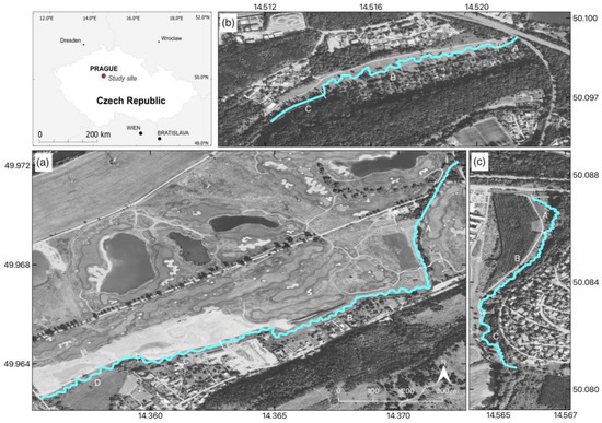
Figure 1.
Study area. Restored streams of the (a) Lipanský (LIP) brook, (b) Rokytka (ROK) brook, and (c) Hostavický (HOS) brook in Prague, Czech Republic, with marked stream reaches used for the assessment of geometric properties.
The stream channels are located on unconsolidated fluvial sediments in valleys with minimal gradients and flat floodplains [40]. The stream gradient values reach 1–1.5‰ for all streams. The width of the floodplain typically varies between 30 and 100 m between the different streams, with the floodplain boundaries generally limited by road embankments [41]. Due to the geomorphological conditions, the streams have historically developed into meandering channels, but these have been gradually straightened due to urban development. The streams have undergone a similar development pathway from natural channels to river training in the 1970s [42]. With the expansion of the metropolitan area and infrastructure, the formerly meandering streams were trained into straight segments, and the formerly natural channels were stabilized using concrete profiles. The area of streams was mostly unmaintained and left to spontaneous succession, resulting in zones of “new wilderness”, typical for abandoned areas in urban or industrial landscapes [43].
With the development of new residential complexes in the environs of the streams after 2000, the City of Prague included these streams in the program to restore small streams in the metropolitan area [44]. The stream restoration projects started circa forty years after stream regulation. Restoration works at the ROK brook started in 2014 and finished in 2015, the HOS brook was restored in 2015, and the LIP brook was restored in 2018. As a result, one-kilometer-long stream segments at the ROK and HOS brooks and a two-kilometer long segment at the LIP brook were restored (Figure 1).
2.2. Design of UAV Monitoring Campaigns
UAV imaging campaigns have started monitoring restored streams since the completion of restoration works. The imaging was scheduled twice a year in the off-growing season in the spring and fall. The regular imaging campaigns were completed with ad hoc campaigns during dry periods and flooding.
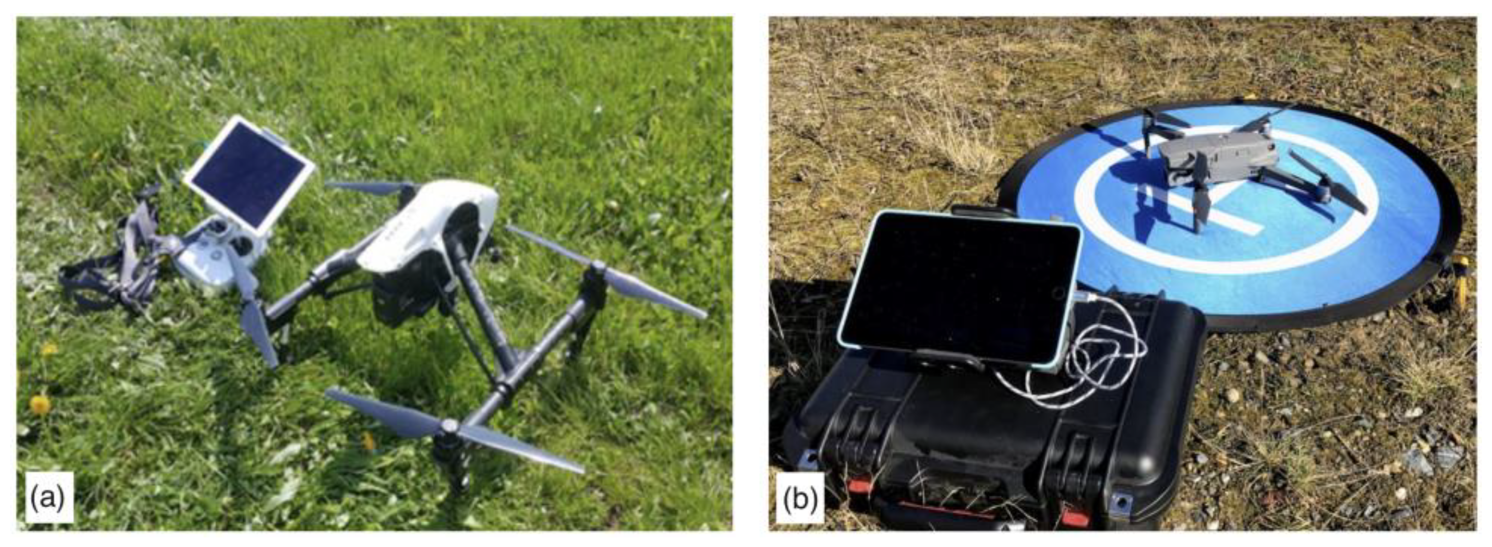
Two imaging platforms were sequentially employed. First, the DJI Inspire 1 Pro imaging platform (I1P) was equipped with a 16-megapixel Zenmuse X5 RGB camera (Figure 2a). Since 2019, the DJI Mavic 2 Pro platform (M2P), featuring a 20-megapixel Hasselblad L1D-20c RGB camera (Figure 2b), has been utilized. DJI Groundstation Pro flight planning software was used to plan the missions, capturing the imagery in identical flight patterns, coverage, and parameters.

Figure 2.
Imaging platforms used for monitoring. (a) DJI Inspire 1 Pro and (b) DJI Mavic 2 Pro.
The parameters of the imaging campaigns were set to allow for the interpretation of changes in the relatively subtle stream channels. The geometric resolution below 2 cm per pixel was defined as a standard for all campaigns. According to the optical parameters of cameras and sensors, the flight routes were taken at altitudes of 60–75 m above ground level (Table 1). The front and side lap were set to 75–80% to secure a sufficient density of image coverage, enabling reliable 3D reconstruction of the riparian zone. According to the length and width of the riparian zone of the streams, the typical flight campaigns consisted of 250 to 620 images (Table 1). Agisoft Metashape Pro 1.6.2 was used for the photogrammetric reconstruction of scenes, employing the Structure from Motion (SfM) algorithm [45]. DroneDeploy software [46] was applied for the rapid quality control of the imagery after the campaigns and as a tool assisting the visual assessment of the selected parameters.

Table 1.
Parameters of UAV monitoring campaigns.
The restored stream segments and their riparian zones were covered by multitemporal RGB sets of seamless orthoimagery, featuring a primary geometric resolution of 1.5–1.7 cm per pixel for 2D orthoimagery and of 3.0–3.4 cm per pixel for the 3D models. To unify the datasets, the processed data were reclassified to a uniform resolution for all streams and time slices. The resulting geometric resolution of the orthoimagery was set to 2 cm/pixel and 5 cm/pixel for the 3D models. Such geometric resolution provides a sufficient level of detail, enabling the detection of detailed characteristics of channel properties and fluvial landforms in an environment of small streams [47,48].
As all the streams are located in the Prague municipality, for all study areas, highly detailed digital technical plans of Prague city infrastructure were available [44]. The technical plans contain multiple layers including detailed information on all types of technical objects and infrastructure in the city, with a geodetic-grade accuracy of location. Stable objects from the plans, which are apparent in detail in the UAV imagery, such as the edges of bridge pillars, waste shafts, and streetlamp poles, were utilized for the georeferencing of the UAV imagery.
Aerial orthoimagery from 2010 was used as the reference source, reflecting the status preceding the restoration projects. The imagery and restoration plans were retrieved from the public online repository of the Prague City public map portal [44]. The restoration plans were digital, enabling their integration with aerial and UAV-based orthoimagery in GIS. As a basis for geoinformatics processing, the digital water management geodatabase of the Czech Republic, DIBAVOD, was employed [49].
QGIS 3.20 was used as a platform for the integration of geospatial data sources and for performing GIS analyses and calculations of vector shapes. The assessment of the geometric properties of stream segments was performed using the RiverMetrics tool in QGIS software [50]. SAGA GIS [50] was employed for raster-based analyses and calculations of morphometric indices.
2.3. Stream Restoration Monitoring Using Uav Imagery
Seamless 2D and 3D models of the riverscape, acquired from high-resolution RGB imagery, are employed as a principal spatial data source to determine the hydromorphological status of restored streams. Two principal aspects of the stream status are determined from UAV imagery: (i) the restoration effect, reflecting the magnitude of change compared to the prerestoration status and the potential deviation from restoration plans, and (ii) the restoration quality, assessing the selected parameters of hydromorphological quality and reflecting fluvial processes, hydrological connectivity, and riparian zones.
The monitoring of stream restorations is focused on stream features, which represents a subset of complex hydromorphological monitoring. Only those indicators for which UAV imagery provided reliable data sources, without the need for additional field surveys or other supporting information, were considered (Table 2).
Table 2.
Suitability of hydromorphological features for UAV monitoring.
As in the hydromorphological mapping, the assessment is performed in stream reaches, allowing us to locate the potentially critical aspects of the restoration projects. The segmentation conforms with the principles of the EU hydromorphological assessment standards [58,59] and the respective national standards for hydromorphological mapping. In this study, the segments with a length varying from 30 to 100 m were delineated according to the principles of the Czech Republic’s national standard HEM [60,61]. The decomposition of the stream into the segments allows for the identification of the critical segments while exploring options for integrating the indicator values for the assessment of the whole restoration project by the principles of hydromorphological assessment and the respective EU guidance standards [59,60].
As the parameters used in the UAV-based monitoring of stream restorations are designed to comply with the hydromorphological monitoring principles set by the EU Water Framework Directive (WFD) [58,59,62], the determined parameters maintain compatibility with the existing hydromorphological monitoring databases. This allows for the use of existing hydromorphological monitoring as a reference to verify the results of the UAV-based monitoring of restorations. In reverse, the compatibility allows for the use of UAV-based monitoring for the verification or updating of conventional hydromorphological monitoring.
2.4. Determination of Indicators of the Restoration Effect and Quality
The assessment of determining the quantitative and qualitative aspects of stream restoration is based on multitemporal UAV orthoimagery. The proposed assessment method was based on the selection of geometric and hydromorphological indicators that can be determined by UAVs and that are relevant for assessing the effectiveness and sustainability of stream restorations (Table 3). The quantitative assessment of the restoration effects applies the GIS calculation of the vectorized streamline for the respective states. The determination of qualitative indicators of restoration is then used in the visual assessment corresponding to the hydromorphological monitoring standards.
Table 3.
Indicators of the restoration effect and quality, derived from UAV monitoring.
2.4.1. Restoration Effect
The three key stages for assessing the restoration effect by determining the geometric changes are the initial status, the restoration plan, and the realized restoration (Table 3). The fit of the restored channel to the approved plan serves as a fundamental indicator, reflecting the general meeting of the restoration goals. Restoration plans are typically designed using hydraulic models and undergo a complex hydroecological evaluation [60,61]. Hence, the substantial deviations of the restored stream from the approved plans should be regarded as a warning sign indicating that the functions of the restored stream in terms of hydraulics, sediment balance, water quality, or hydrobiology may be different than expected.
The source of data for the initial and planned status depends on the data availability in a given catchment. If UAV monitoring is deployed after the completion of the restoration project, the pre-restoration state of the stream can be derived from aerial orthoimagery. The restoration plans are mostly available in digital form as GIS layers that can be directly overlayed by the data derived from UAV monitoring.
The restored channels typically have completely or significantly reshaped channel planforms [8]. As restoration projects alter the planform of long stretches, the assessment of changes in geometric properties cannot use the fine structure of stream segments designated for hydromorphological surveys, as the same segments cannot be identified in the respective stage. The quantitative assessment is thus performed on complex stream reaches, delineated according to the stable elements of the stream adjacent to unchanged structures such as the bridges (Table A1, Figure 1).
The difference between the restored and restoration or planned status in stream length, sinuosity, and meander count was calculated within the elementary reaches. The calculations were performed in the GIS. For all parameters, the absolute values and the relative differences in the restoration status were expressed to quantitatively assess the fit of the realized restoration to the approved plans.
2.4.2. Restoration Quality
The qualitative assessment is focused on the principal aspects of changes affecting the hydromorphological and ecological quality of streams, such as the channel morphology, hydrological processes, and riparian vegetation (Table 3). The restoration quality and evolution of the stream after the project completion were assessed on the basis of UAV monitoring data in stream reaches delineated on the planform of the resulting restoration according to the principles of hydromorphological monitoring [60,61].
The determination of hydromorphological features and the assessment were based on the standard methodology of a hydromorphological survey, using, as the basis, the high-resolution, seamless orthophoto map from the UAV monitoring instead of a field survey for the visual assessment. The conjoint availability of the 3D model, along with the high-resolution orthophoto map resulting from the photogrammetric assessment, allows for a detailed exploration of the morphometric features of the stream (Figure 3). The determination of some parameters, such as the water quality or the coherence of riparian vegetation, can be supported by the calculation of spectral indices or by classifications derived from UAV orthoimagery, even in the case of RGB imagery [8]. In addition to the scoring of the indicators in segments, UAV orthoimagery and 3D models provide information for the further interpretation of the critical aspects of the restorations and for their detailed analysis.
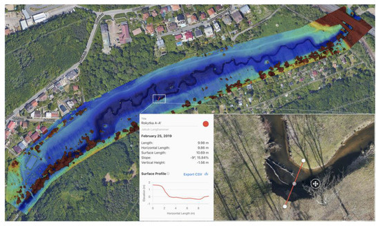
Figure 3.
Interactive exploration of a cross-section for assessing channel variability, employing a 3D model from UAV imagery in DroneDeploy software. Rokytka brook, 2020, imagery: J. Langhammer.
The scoring of the qualitative parameters applies the methodology of hydromorphological monitoring. Within the EU, the hydromorphological monitoring and assessment of hydromorphological parameters conform to the principles defined by the Water Framework Directive and subsequent standards [60,61]. However, the particular definitions of parameters and scoring systems vary at the national level according to the approved standards. This study’s scoring was based on assessing hydromorphological parameters according to the HEM methodology, approved in the Czech Republic and conforming to the EU standard [60,61].
3. Results
The three assessed streams and the respective restoration projects share multiple common properties, resulting in similar aspects of the restorations. All streams are located in a comparable physiographic environment and have undergone similar pathways of anthropogenic modifications. The restoration projects were designed and realized under the same principles and by the same investor, which resulted in a similar approach to the design of stream restoration projects. All of the realized restorations contributed to overall improvements in the hydromorphological status and the aesthetic value of the riverscapes. However, in all of the restoration projects, UAV monitoring detected significant shortcomings. Some of these shortcomings are common for all projects, and some of them are site-specific.
3.1. Changes in the Geometric Properties of the Restored Streams
In all the assessed streams, the restorations resulted in a significant improvement in the hydromorphological status of the stream in terms of geometric properties compared to the pre-restoration period (Table 4).
Table 4.
Differences in geometric properties of the restored streams, comparing the initial status and the planned and realized restoration.
For the ROK brook, the oldest of the three restoration projects, the total length of the restored stream increased from 845 to 979 m, and the sinuosity increased from 1.03 to 1.25. In the HOS brook, the total length of the restored stream segment increased from 760 to 1004 m, and the sinuosity increased from 1.01 to 1.39. In the LIP brook, the stream length of the restored segment, compared to the initial status, increased from 1917 to 2248 m, and the sinuosity increased from 1.06 to 1.28 (Table 4).
In all cases, stream restorations resulted in meandering channels that basically aligned with the plans and fit to the natural stream patterns corresponding to the given environment. However, all realized restorations are significantly less complex than planned. In the oldest restoration project (ROK), there is the highest deficit in length between the planned restoration and the realized restoration (−19.5%); in the most recent project, the new stream is shorter by just 9.5%. The deficit in stream sinuosity and the number of meanders are, to the contrary, the worst in the newest project, the LIP brook. The deficit in stream sinuosity reaches 12.8%, and the number of constructed meanders is lower by 58.2% (Table 2). In all projects, the deficiency of the stream length and sinuosity reaches almost half of the gain reached by the restoration (Figure 4). Such reduced complexity significantly limits the expected hydroecological effects of the restorations.
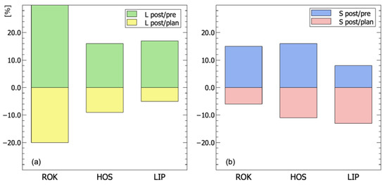
Figure 4.
The relative difference in the (a) stream length and (b) sinuosity of the assessed streams.
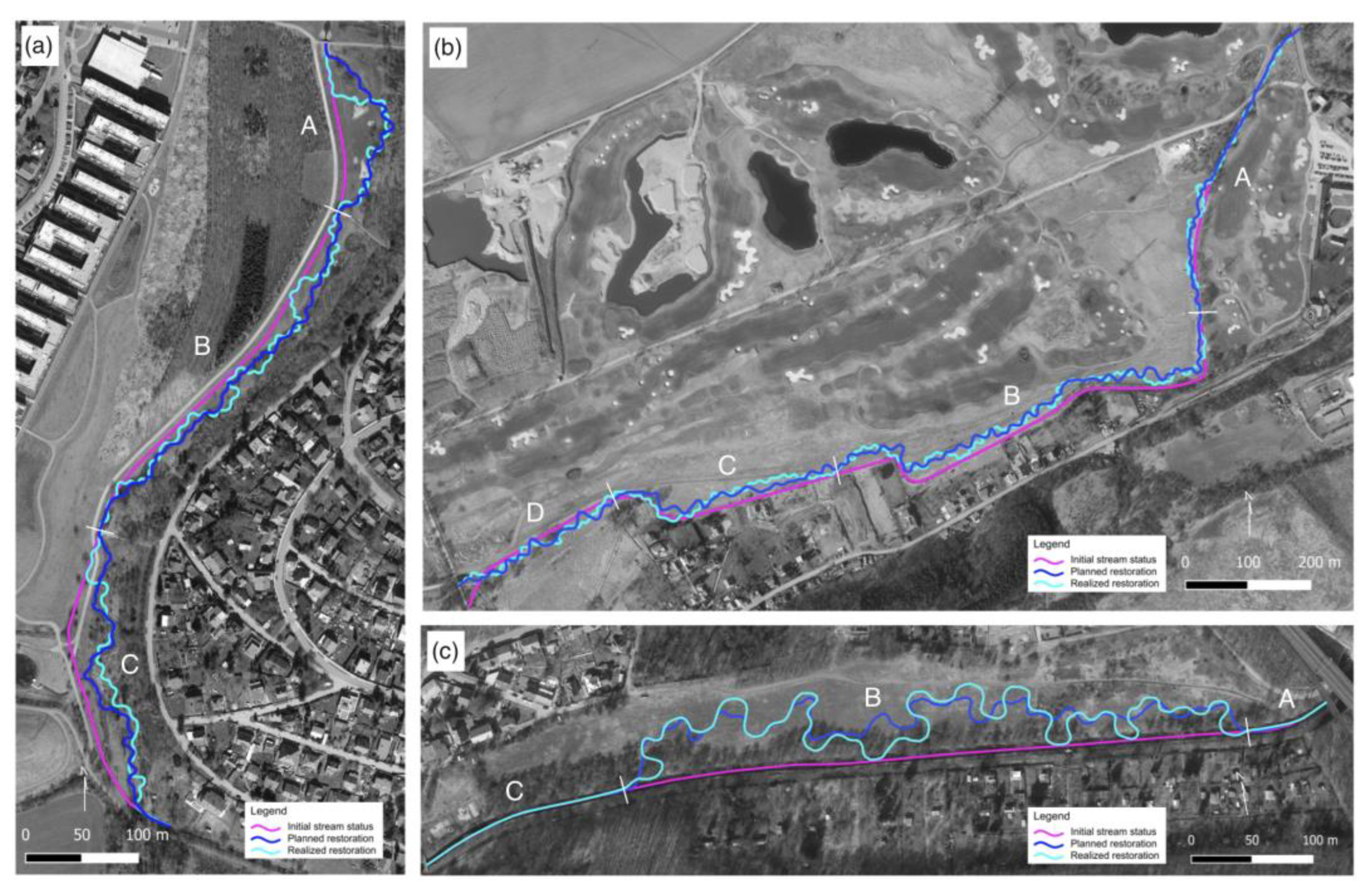
When assessing the stream geometry in individual stream reaches, there are even more profound discrepancies within the restored streams. In the boundary reaches around the bridges and regulation structures, where there is only limited space for deviations, the realized restorations mostly fit the plans (Table A1). In contrast, in the central parts of the restored streams, the channel route is formed relatively freely, with significant deviations in geometric parameters but also in the channel route from the approved plans (Figure 5). In all the realized restorations, the new channels substantially deviated from the planned route, with meanders built in the opposite direction compared to the plan. Most new meanders were built in different locations with different sizes and amplitudes. The same situation applies to the newly built ponds, which are chiefly constructed in different locations.
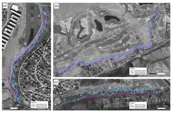
Figure 5.
Stream restoration projects featuring the channel’s pre-restoration, planned, and post-restoration status with marked delineation of reaches, used for the assessment of geometric properties. (a) Hostavický brook, (b) Lipanský brook, and (c) Rokytka brook.
3.2. Changes in the Qualitative Aspects of the Restoration Projects
Although the resulting restorations are visually pleasant in all cases, the analysis of the qualitative parameters identified critical aspects in most of the observed parameters. In the three streams, issues were identified among almost all of the assessed parameters, reflecting the changes in the channel morphology, flow connectivity, and quality of the riparian zone. While the deficiency in the complexity of the geometric properties of restoration can be considered a general feature in the geometric properties, the detected issues in the qualitative aspects of stream restorations have different scopes across individual catchments and parameters and are site-specific (Table A2).
3.2.1. Channel Morphology and Stability
All of the assessed restoration projects were focused on removing the intense forms of channel modifications, such as reinforcements of the banks by riprap or channelization into concrete profiles. This primary aim of the restoration was fulfilled in all streams. The bank and bottom reinforcements were removed, and new channels were built without modifications, with the exception of the terminal segments of streams, passing under road or rail bridges and in the isolated segments adjacent to pedestrian bridges, sidewalks, or buildings. In all the streams, there is an apparent initiation of fluvial processes after restoration, although with different extents and dynamics. Their intensity is affected by bank stabilization and riparian zone conditions after restoration completion.
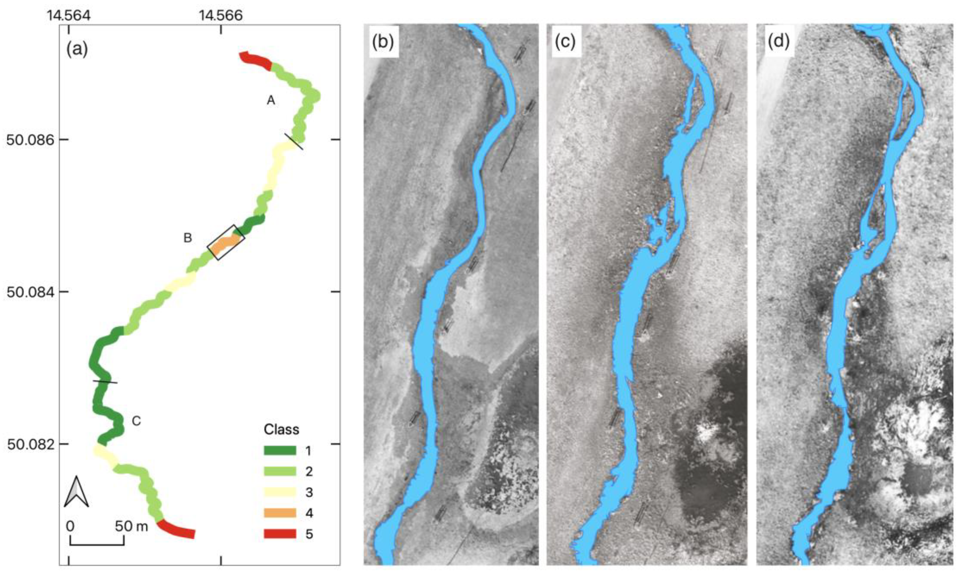
In the ROK brook, the restored reach is free from channel modification, with the exception of the initial and terminal segments. In both cases, straight segments are reinforced by riprap due to the vicinity of the road and railroad bridge. The central part features a meandering stream with no artificial barriers and high variability in the stream width and bed (Figure A1, Table A2). In this part of the restored stream reach, there is extensive bank instability (Figure 6b). The meander, which features the propagation of high-intensity bank erosion, is located in a segment built with substantially different geometric properties than those of the approved plan. The erosion in a bare bank has a height of 2.4 m, and an intense scour drives its propagation (Figure 6c).
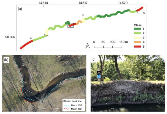
Figure 6.
Assessment of channel stability at the ROK brook. (a) Classification of channel stability in segments. (b) Progress of bank erosion in a highlighted critical segment between 2017 and 2021. (c) Bare erosion bank of the active meander in the given segment. Imagery: J. Langhammer, 2017–2021.
The HOS channel (Figure A2b) was disturbed by a spring storm flood in June 2016, just a few months after the completion of the restoration works. The flood reached the newly built channel with a bare riparian zone prior to grassing. In the central segment, the flood thus initiated several spots of minor bank erosion, from which the stream wandering started to propagate, although to a limited extent (Figure 7).
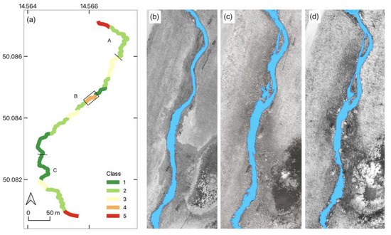
Figure 7.
Stream wandering in the central segment HOS (a) after the completion of the restoration. (b) Bare riparian zone after the completion of the restoration in March 2016. (c) Initiation of stream wandering after the summer storm flood in June 2016. (d) Stabilized channel pattern after the first vegetation season, March 2017. Data: UAV monitoring, 2016–2017.
In the LIP brook, the restored channel remained stable (Figure A3b). The first vegetation season after the restoration (2019) lacked significant peak flows, so the riparian zone became grassy and stabilized. The summer storm flood in 2020 thus had no negative effects on the channel stability, and there were no apparent traces of bank erosion or channel wandering after flooding.
3.2.2. Hydrological Processes
All of the assessed restoration projects aimed to remove the in-stream obstacles to flow continuity, such as steps or weirs, and this aspect was maintained in the realized channels. All three streams were thus restored to a state that supports free-flow continuity in the stream. However, the flow continuity was negatively affected by the design of new channels and by water use. Moreover, in all streams, there are persisting limitations of hydrologic connectivity between the stream and the floodplain.
Only minor issues in hydrologic connectivity were identified in the ROK brook (Figure A1d,e). The riparian zone’s lateral connectivity is limited by the road and a pedestrian sidewalk, passing the valley bottom along the stream. However, as the restored segment is located in an urbanized area and the sidewalks are located at the outer fringe of the riparian zone, where possible, the resulting state corresponds to the stream restoration potential in the given environment. The ROK brook has a regulated discharge controlled by a system of reservoirs upstream of the restored reach, preserving minimum discharge levels in dry seasons. The occurrence of in-stream eutrophication was thus only marginal here, even during the intense droughts in the summers of 2018 and 2019.
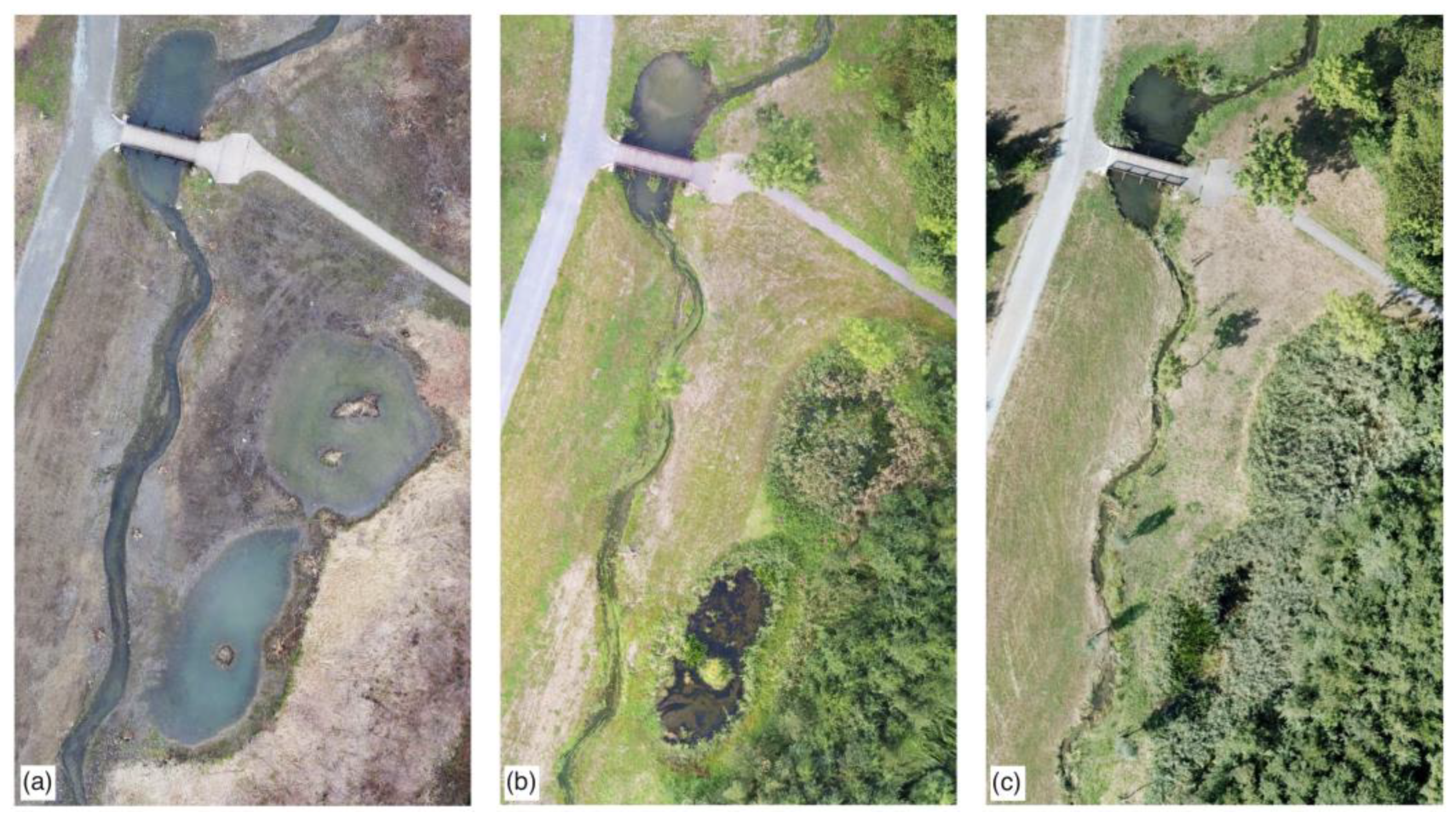
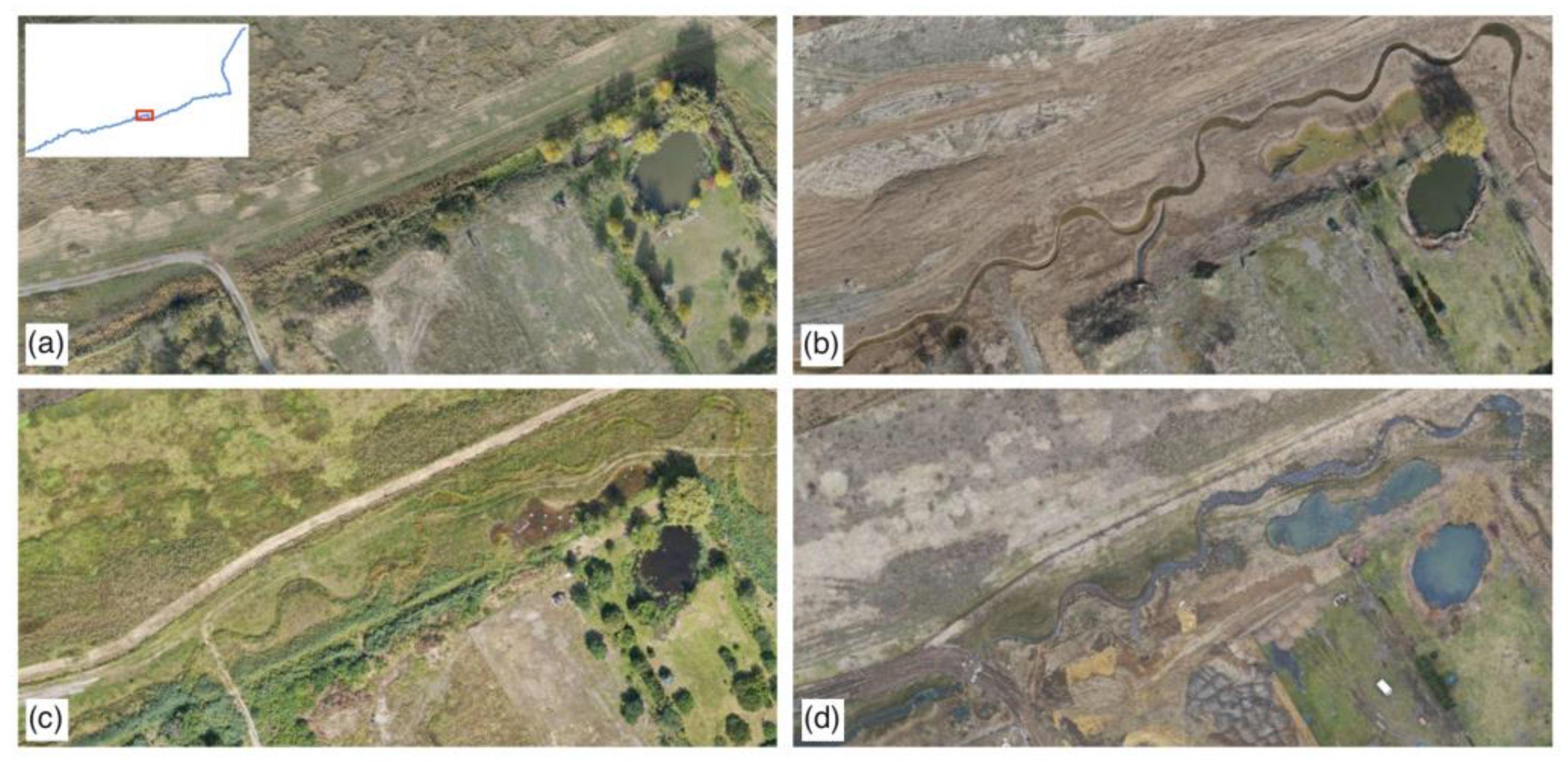
In HOS, minor limitations of the stream and floodplain connectivity (Figure A2e) by the sidewalks forming a dike in the outer space of the floodplain were detected. The spill during a flash flood in 2016 [8] showed their impact on the reduction of the potential flood spill. More significant are the issues in the connectivity of newly built ponds. The ponds were built in different locations than those in the approved restoration plan and without a direct hydrological connection with the stream. As a result, extensive eutrophication in the ponds and overgrowth by reeds have occurred since the restoration (Figure 8). Five years after the restoration, both new ponds almost disappeared under overgrowing reeds. During the critical period of drought in the summer of 2019, the in-stream water had apparent signs of turbidity and algae, particularly in the low part of the segment.

Figure 8.
Progress of eutrophication and overgrowth in the newly built ponds at HOS. (a) April 2016, (b) June 2017, (c) August 2018.
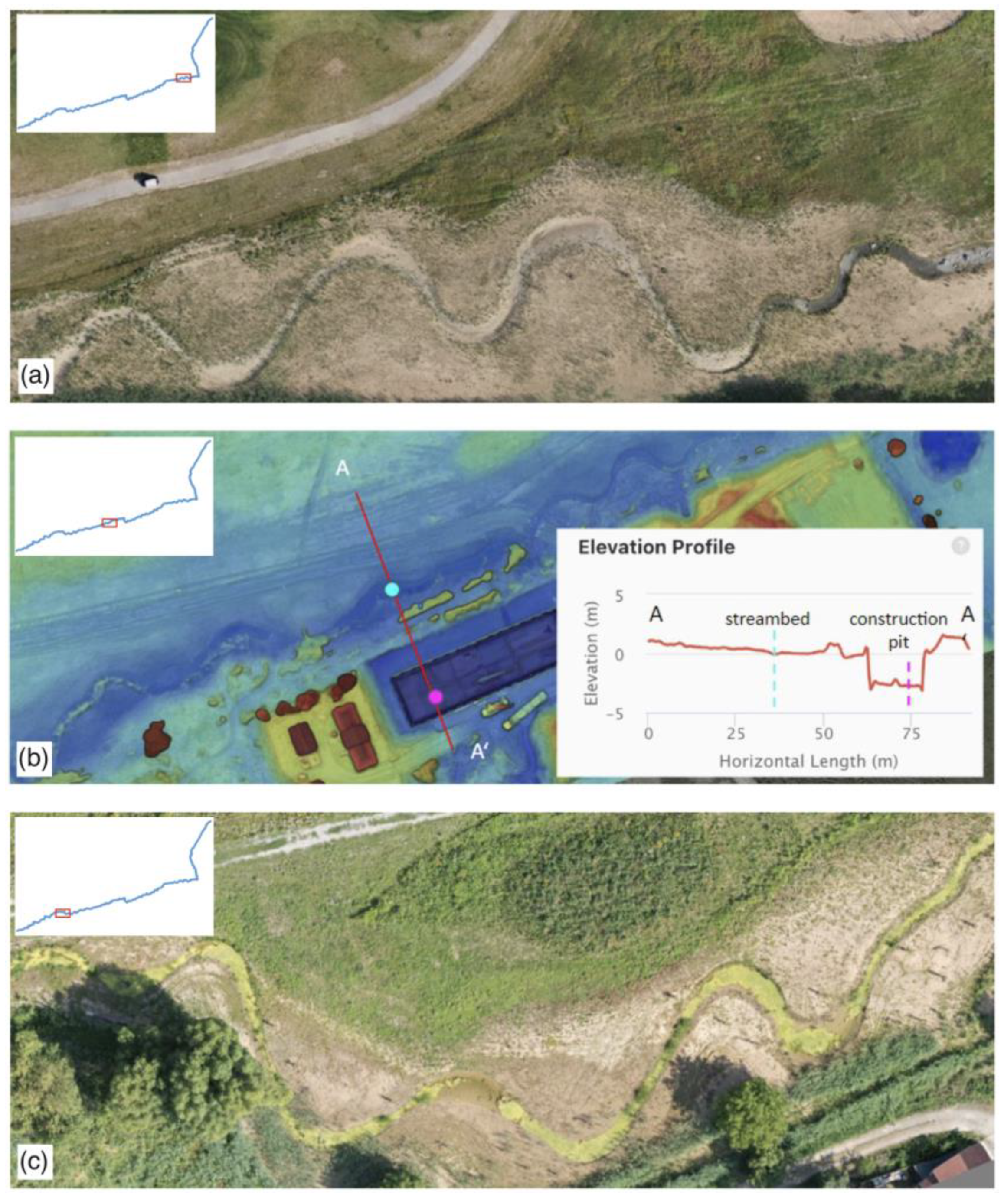
The most critical issues in flow continuity and floodplain connectivity were detected in the LIP brook, despite its highest potential given the natural conditions and low anthropogenic pressures (Figure A3). The restored segment of the LIP brook is located on a fringe of a large natural floodplain, and the restoration achieved the best fit of the geometric properties to the plan. However, UAV monitoring revealed significant issues in the flow continuity and floodplain connectivity, leading to the deterioration of the hydroecological functions of the stream. Before the restoration, the trained stream was located along the slope of the alluvial terrace with a road and sparse housing, limiting the spill on its right bank. The restoration could have used the wide and flat floodplain to re-establish the meandering system. This space is, however, occupied by a golf course and separated from the riparian zone by a new dike. The dike leaves only a limited corridor for the new meandering belt and breaks the hydrological connectivity between the stream and the floodplain (Figure A3d,e).
The new channel is almost twice as long, has a wide and shallow bed profile with a higher capacity that corresponds to the hydrological conditions, and is built on highly permeable soil. Moreover, the stream is subject to water extraction in the central part of the segment. As a result, the restored channel dries in summers in a coherent and long stream segment. The same condition applies to the ponds. The existing pond in the mid-section of the segment, which was formerly connected by an inflow and outflow with the stream, was cut from the channel during restoration works. Since then, the pond has dried and is subject to heavy eutrophication. The newly built ponds were designed without a direct connection to the stream; thus, they dry during the summer season (Figure 9a).

Figure 9.
UAV-assisted detection of the qualitative issues in hydrological processes in the LIP brook. (a) Drying of the channel in the summer season, (b) 3D model of the construction pit along the restored stream, and (c) in-stream eutrophication developed after the project termination in July 2019.
Another issue in water connectivity results from the construction works along the restored stream. In 2021, just two years after the completion of the restoration, the construction of new buildings near the restored stream commenced. The UAV-based 3D reconstruction of the site revealed that the construction pit located by the stream bank reaches 7 m below the former terrain level and 3 m below the channel bottom (Figure 9b). This resulted in lowering the groundwater level in the central part of the restored channel, which already suffered from drying in the summer seasons. UAV monitoring also showed a substantial disturbance of the previously restored channel and the riparian zone as a side effect of heavy machinery traffic at the construction site. The lack of coordination in construction activities with water management in the riparian zone caused the devaluation of the restoration efforts. UAV-based monitoring in the summer seasons helped to detect eutrophication in streams and ponds, accelerated by the hot and dry summer seasons in 2016–2019.
The restoration, which was completed in 2018, caused a significant deterioration of water quality in the LIP brook in the following seasons. The release of sewage from the residential zone in the lower part of the segment impacted the deterioration of water quality and in-stream eutrophication (Figure 9c). The persistence of pollution is apparent in the UAV imagery by detecting the turbidity of the water column, which is present even in high-water-level conditions during the early spring campaigns, such as March 2021.
The stream enters a dire state with the abovementioned issues and the disruptions in hydrologic connectivity during the summer season. A significant part of the restored segment is dry, and the other half features massive in-stream eutrophication, almost coherently covering the upper half of the stream with a length of 1 km. This situation was repeated in all consequent summer seasons of monitoring, which were substantially wetter and colder than those in 2019, the first year after the restoration. The extent and intensity of water quality issues significantly limit the sustainability of the hydroecological functions of the stream.
3.2.3. Riparian Vegetation
Coherent and mature riparian vegetation is vital for the natural stability of the channel, preventing excessive bank erosion and stream wandering, and in providing riparian shading [63]. However, riparian vegetation almost always significantly changes during restoration projects. After the physical completion of the restoration, streambanks usually become bare and vulnerable to bank erosion triggered by floods or peak flows. The first season after restoration completion is thus critical for the future stability and sustainability of the restored riparian zone.
In the three observed streams, the assessment of the streambank vegetation restoration showed coherent grassing of the riparian zone within two years after the project completion (Figure A1g, Figure A2g and Figure A3g). In the ROK and HOS brooks, two years after the restoration, the riparian zone was covered by coherent grass, with newly planted trees on the banks and abundant riparian vegetation in the vicinity of the stream. In the LIP brook, the initial revegetation of the riparian zone successfully progressed over the first two years after the restoration despite the dry summer seasons. However, in the fall of 2020, construction works in the central part of the restored stream disrupted the newly vegetated riparian zone. Thus, at the beginning of the 2021 season, a substantial part of the streambanks in the central segment became bare again and vulnerable to erosion (Figure 10d).

Figure 10.
Changes in riparian vegetation coherence in the LIP brook. (a) Pre-restoration status (October 2018), (b) Completed restoration (March 2019), (c) One year after restoration (July 2020), (d) Disturbance of the completed restoration by construction works (March 2021). Imagery: J. Langhammer, 2018–2021.
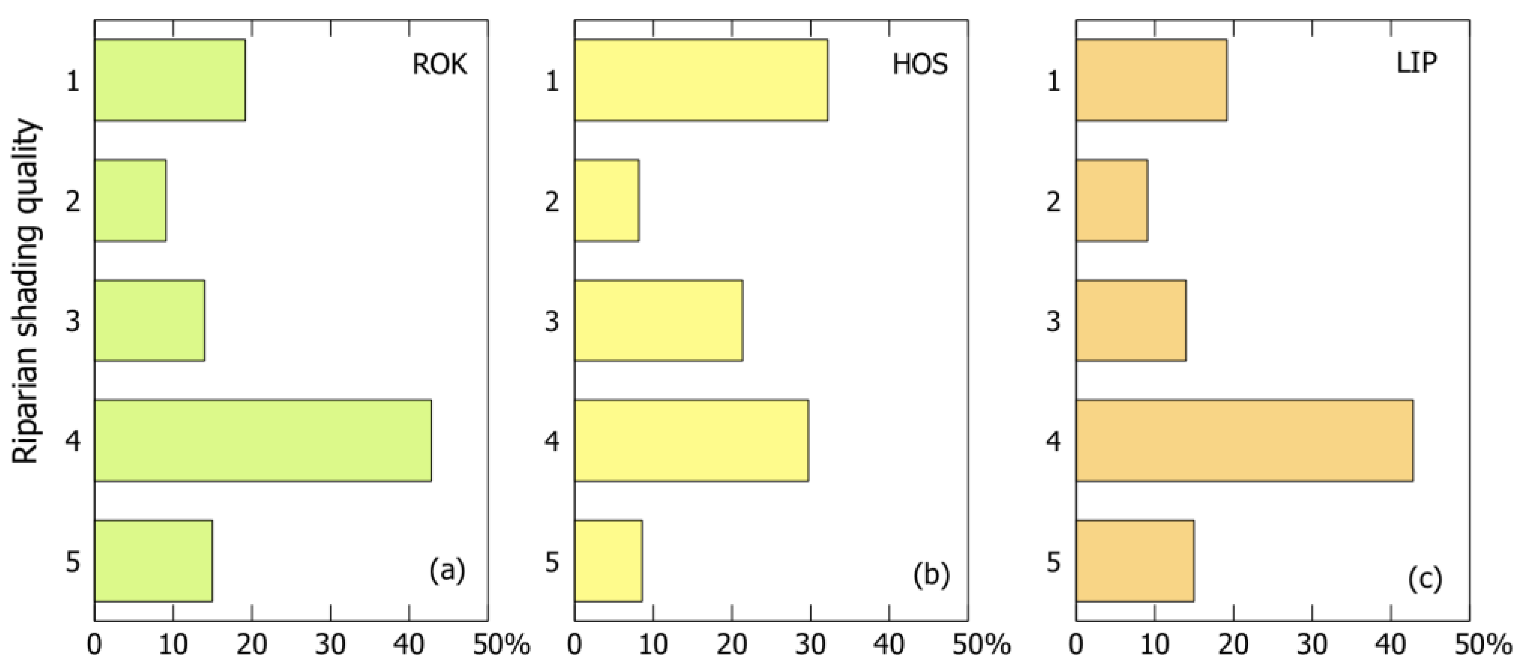
As a repeating problem, a deficiency of riparian shading has been identified. In all of the assessed streams, the restoration projects have deviated substantial parts of the new channels from the existing mature vegetation. Most of the extent of the restored channels was thus left without riparian shading (Figure 11). In part, such deficiencies are substituted by planting new trees along the channel in ROK and HOS.
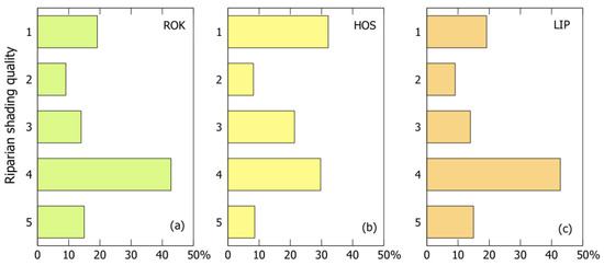
Figure 11.
Assessment of the riparian shading indicator. Share of riparian shading quality classes on the restored stream length. (a) ROK, (b) HOS, and (c) LIP. Data: UAV monitoring, 2021.
In the ROK brook, only the initial part of the assessed stream provides shading and potential for wood recruitment from large trees with overhang branches. The whole central segment with the new meandering belt is exposed to sunlight, and the isolated shrubs on streambanks provide only limited shading. The efficient shading by trees and overhang branches is at 19.2% of the stream, however, in a terminal straight segment of the stream (Figure A1h).
In HOS, the greatest extent of riparian shading was observed on the restored stream (32.2%), spread in different parts of the restored stream (Figure A2h). The channel is covered by the overhanging canopy of large mature trees in three parts, providing efficient shading in the summer season. In the long central segments exposed to sunlight, new trees were planted, with the potential for shading in the future.
The LIP brook had the worst initial conditions for riparian shading and the potential for wood recruitment from the three streams at the starting point of restoration. This unfavorable situation worsened after restoration completion. The only coherent part of the stream providing efficient riparian shading is concentrated in one short segment in the lower part of the stream (Figure A3h). There are isolated spots with individual trees and shrubs in the upper part of the restored stream; however, each spot is, at most, 5% of the length of a respective segment.
A systematic lack of riparian shading and conditions for the presence of woody debris in the long and coherent stream reaches could deepen the water quality issues and limit the amelioration of the hydroecological status of this stream after its restoration.
4. Discussion
High-resolution optical imaging from UAVs and photogrammetric reconstruction techniques provide objective, detailed, and reliable data sources for fluvial geomorphology, allowing for the assessment of various aspects of the stream state and restoration [22,56,64]. UAV platforms providing programming of flight mission parameters ensure consistent coverage and image data quality during data acquisition. Using high-resolution, RGB digital cameras was indicated to be a reliable data resource for detailed topographic reconstruction using the SfM algorithm [30,35,65]. UAVs with RGB cameras thus become common tools in geosciences, significantly facilitating rapid field mapping. Due to the very high spatial resolution of UAV imagery, the multitemporal reconstructions of the riparian zone provide an objective determination of the discrepancies in geometric properties at a centimeter-level resolution.
For monitoring river environments, the optical nature of the sensing is a source of limitation. Unlike active lidar, passive optical sensing in river environments is limited to scenes with direct visibility. The riparian vegetation and overhang canopy thus represent a significant obstacle for mapping channel properties in natural landscapes. The problem of limited channel visibility by optical sensors can only be partially solved [30,66]. Technically, multiple views of an object from different angles across the imagery can resolve obscured views in the case of isolated trees. Scheduling the imaging campaigns off the vegetation season helps bypass even extensive obstruction by a deciduous canopy.
Despite the abovementioned limitations, UAV monitoring has the potential to improve the quality of hydromorphological and restoration monitoring. Highly detailed, timely, and complex spatial data resources are vital for objective analysis. The assessment can benefit from the existing principles and approved methodologies in hydromorphology and hydroecology and maintains the compatibility of the monitoring [8,23,25].
However, the post-project monitoring of stream restorations is still rare [63]. The systematic monitoring and evaluation of the effects of restoration should be an inherent part of restoration projects [10]. The lack of objective and detailed information from project evaluations leads to repeated errors in restoration design, undetected deficiencies in the adherence to implementation plans, or an inability to recognize the symptoms of restoration failure.
The six-year-long, recurrent UAV monitoring of three restored streams in an urban environment enabled us to assess the principal issues limiting the effect and sustainability of the assessed restoration projects. The availability of detailed data sources for spatial analysis helped overcome the limited information on the post-project evolution of the assessed stream restoration projects [63,67]. The analysis revealed the variable nature of issues in realized restorations, some of which are common for all assessed projects and some of which are locally specific.
In particular, in all the assessed streams, the restoration projects were aimed at restoring the stream planform into highly sinuous meandering channels corresponding to the natural stream types in the given environment. Compared with the pre-restoration status, all of the projects significantly improved the geometric properties of the streams. The stream length increased in all streams by 15.9–32.0%, and the stream sinuosity increased by 8.3–15.6%.
Despite these improvements, UAV monitoring revealed that the realized restorations were built to be significantly less complex than planned. Compared to the approved plans, the deficit in restoration complexity reached almost half of the planned change when comparing the initial status with the realized status (Table 2). In addition to the simpler geometry of the new channels, most of the new stream meanders were built in different locations, with different sizes, numbers, and amplitudes. The issues in the geometrical properties of streams and their limited complexity compared to the approved plans can thus be considered a general phenomenon, repeating across the assessed catchments, which is reported as a frequent problem in the literature [9,10].
The fluvial processes in the newly shaped channels, which were built to be mostly free from artificial bank reinforcement, were restarted, and in all streams, traces of channel instability of different magnitudes were identified. The extent of bank erosion and stream wandering was dependent on the meander design, the stabilization of streambanks by grassing after the restoration project completion, and the occurrence of storm floods.
After restoration, all of the assessed streams were free from obstacles in the longitudinal profile, such as weirs and steps. However, in all streams, UAV monitoring revealed multiple issues in flow continuity and issues of hydrological connectivity between the stream and the floodplain. The detected issues were caused mostly by the inappropriate design of new channels, the extensive water use, and the intense development of the riparian zone, limiting the water spill in the floodplain. The nature of issues in the qualitative aspects of restoration varied according to the locally specific conditions in the individual catchments.
As the oldest restoration, the ROK brook, which was restored in 2014, features the coherent revegetation of the floodplain, with segments of mature vegetation that provide efficient riparian shading. This stream features the amplest differences in stream geometry between the planned restoration and the realized restoration, particularly in terms of stream length and sinuosity. The stream and floodplain connectivity was significantly improved. However, some of the newly built meanders are in different locations than planned, which causes massive bank erosion.
In HOS, which was restored in 2015, the principal positive aspect of restoration was the stability of the restored channel and the revegetated floodplain, which was proven by a summer storm flood. The new channel route was located with the existing mature vegetation, so, from the beginning, the new channel was subject to riparian shading by the overhanging canopy. The critical aspect of this restoration project is the substantial divergence of the restoration elements from the approved plan. The missing hydrological connection of newly created ponds causes massive eutrophication and overgrowth in the vegetation season.
In the LIP brook, which was restored in 2018, the newly created channel fits best with the approved restoration plans. The new channel is stable, without hotspots of extensive bank erosion or accumulation due to stream wandering. However, the restoration design did not use the potential of existing mature vegetation, so the restored segments are almost without riparian shading. With an inappropriate channel capacity and water pollution, the stream features water deficiency and even drying in the summer seasons and extensive in-stream eutrophication supported by wastewater releases.
The study of the post-restoration changes in three urban streams pointed to the importance of the assessment of both quantitative and qualitative aspects in monitoring. For example, in the case of the LIP brook, despite a positive change in the geometric characteristics of a stream (length and sinuosity), the deficiencies in the qualitative parameters (flow continuity, water quality, and riparian shading) devaluate the resulting ecological functions of the stream and thus the sustainability of the restoration project. Such qualitative monitoring is, however, often not implemented because of the demands for special skills required for hydromorphological surveys and the determination of parameters in the field. This study demonstrated that UAV monitoring has the potential to provide reliable spatial information, enabling the assessment of the critical geometric and qualitative aspects of stream restorations. UAV monitoring using RGB sensors cannot fully replace field surveys in the full range of ecohydrological parameters. However, we demonstrated that RGB sensors allow us to assess a range of parameters covering the principal aspects, potentially limiting the effectiveness of stream restoration and its sustainability. UAV monitoring using RGB sensors can thus be a routine tool for monitoring restoration success and providing information that is compatible with standard monitoring schemes.
5. Conclusions
UAV monitoring enabled the identification of stream restoration features that are critical for the effect and sustainability of the restoration projects. Regarding the restoration effect, the UAV assessment showed that, although the primary goals of the restoration projects were fulfilled, the new stream patterns significantly differed from the approved restoration plans.
The analysis of the three restoration projects indicated significant and systematic discrepancies between the realized restorations and planned restorations. The restored channels are less complex and feature a simpler geometry than planned. In particular, the resulting stream lengths were 4.9 to 19.5%, lower than those of the approved restoration projects, the sinuosity was 6.2 to 12.8%, lower than that of the approved restoration projects, and the number of meanders was even lower, by 58%. Such deficit in the complexity of the realized restorations deteriorates the positive effect of the projects and limits their sustainability.
In addition to the quantitative aspects of geometric properties, UAV monitoring indicated substantial shortcomings in the qualitative aspects of the restorations in streams and riparian zones. The multitemporal assessment indicated stream segments featuring instability after restoration and enabled us to track the extent of bank erosion. UAV monitoring in low-flow periods helped us to identify the disruptions of hydrological connectivity. Even using RGB sensors, UAV imagery revealed the extent of eutrophication in streams and ponds, enabled the tracking of the progress of vegetation succession after the restorations, and indicated the deficiencies in riparian shading as important ecohydrological elements of stream restorations.
The study highlighted the importance of the conjoint assessment of quantitative and qualitative aspects of stream restorations projects. The case studies showed how, despite a positive change in the geometric properties of a stream, the deficiencies in the qualitative parameters can devaluate the resulting ecological functions of the restored system.
We have demonstrated that UAV monitoring using optical RGB sensors, being the most common and affordable tool for drone-based mapping, has the potential to provide reliable and feature-rich spatial information, enabling the assessment of the critical geometric and qualitative aspects of stream restorations. Merging the potential UAV optical imagery and photogrammetric reconstructions with existing and proven hydromorphological assessment methods can facilitate the better availability, quality, consistency, and reproducibility of information on stream restoration effectiveness and sustainability.
Author Contributions
Conceptualization, J.L.; methodology, J.L.; software, J.L.; validation, J.L. and J.Š.; formal analysis, J.L.; investigation, J.L. and J.Š.; resources, J.L.; writing—original draft preparation, J.L.; writing—review and editing, J.L. and T.L. All authors have read and agreed to the published version of the manuscript.
Funding
The research was funded by the European Cooperation in Science and Technology COST CA16219 project “Harmonization of UAS techniques for agricultural and natural ecosystems monitoring”.
Data Availability Statement
Not applicable.
Conflicts of Interest
The authors declare no conflict of interest.
Appendix A
Table A1.
Stream geometry characteristics by stream and reach.
Table A1.
Stream geometry characteristics by stream and reach.
| Stream Length | Sinuosity | Meander Count | |||||||||
|---|---|---|---|---|---|---|---|---|---|---|---|
| Stream | Reach | Number of Segments | L Pre | L Plan | L Post | S Pre | S Plan | S Post | M Pre | M Plan | M Post |
| HOS | 24 | 845 | 1076 | 979 | 1.02 | 1.33 | 1.18 | 0 | 121 | 94 | |
| HOS A | 6 | 149 | 248 | 238 | 1.01 | 1.32 | 1.23 | 0 | 21 | 19 | |
| HOS B | 11 | 451 | 526 | 460 | 1.01 | 1.38 | 1.12 | 0 | 76 | 54 | |
| HOS C | 7 | 245 | 302 | 281 | 1.04 | 1.29 | 1.19 | 0 | 24 | 21 | |
| ROK | 21 | 760 | 1246 | 1003 | 1.02 | 1.33 | 1.18 | 0 | 46 | 34 | |
| ROK A | 2 | 83 | 86 | 91 | 1.01 | 1.02 | 1.03 | 0 | 0 | 1 | |
| ROK B | 15 | 489 | 970 | 720 | 1.02 | 1.67 | 1.42 | 0 | 46 | 33 | |
| ROK C | 4 | 188 | 190 | 192 | 1.01 | 1.02 | 1.04 | 0 | 0 | 0 | |
| LIP | 57 | 1917 | 2363 | 2247 | 1.08 | 1.34 | 1.17 | 2 | 134 | 104 | |
| LIP A | 12 | 487 | 593 | 526 | 1.05 | 1.24 | 1.13 | 0 | 21 | 17 | |
| LIP B | 21 | 690 | 850 | 833 | 1.19 | 1.53 | 1.21 | 1 | 58 | 43 | |
| LIP C | 13 | 395 | 502 | 476 | 1.05 | 1.29 | 1.12 | 1 | 28 | 24 | |
| LIP D | 11 | 345 | 418 | 412 | 1.02 | 1.29 | 1.20 | 0 | 27 | 20 | |
Table A2.
Assessment of qualitative parameters by stream and reach.
Table A2.
Assessment of qualitative parameters by stream and reach.
| Channel Morphology | Hydrology | Riparian Vegetation | |||||||||
|---|---|---|---|---|---|---|---|---|---|---|---|
| Stream | Reach | Sinuosity | Channel Modifications | Channel Stability | Channel Variability | Flow Continuity | Floodpl. Connectivity | Water Quality | Vegetation Coherence | Riparian Shading | Large Wood |
| HOS | 2.6 | 2.0 | 2.4 | 2.4 | 1.0 | 2.5 | 2.3 | 1.7 | 3.2 | 2.7 | |
| HOS A | 5.0 | 4.5 | 3.5 | 4.5 | 1.0 | 4.5 | 3.0 | 1.0 | 2.0 | 3.5 | |
| HOS B | 1.8 | 1.0 | 2.0 | 1.5 | 1.0 | 2.0 | 2.3 | 1.9 | 4.0 | 2.5 | |
| HOS C | 4.5 | 4.8 | 3.5 | 4.8 | 1.0 | 3.3 | 2.0 | 1.0 | 1.0 | 3.0 | |
| ROK | 2.9 | 2.2 | 2.3 | 2.0 | 1.0 | 2.5 | 2.3 | 1.6 | 2.7 | 3.0 | |
| ROK A | 2.5 | 3.5 | 2.7 | 2.7 | 1.0 | 2.8 | 2.0 | 1.3 | 1.8 | 2.5 | |
| ROK B | 3.2 | 1.0 | 2.0 | 1.5 | 1.0 | 2.0 | 2.4 | 1.9 | 3.9 | 3.7 | |
| ROK C | 2.9 | 2.9 | 2.3 | 2.4 | 1.0 | 2.9 | 2.6 | 1.3 | 1.6 | 2.1 | |
| LIP | 2.3 | 2.0 | 2.1 | 1.8 | 3.0 | 3.3 | 4.0 | 2.4 | 3.4 | 3.2 | |
| LIP A | 3.4 | 2.8 | 2.3 | 2.2 | 3.0 | 2.4 | 4.0 | 1.7 | 3.1 | 3.2 | |
| LIP B | 2.5 | 2.1 | 2.4 | 1.5 | 4.4 | 3.5 | 4.4 | 3.4 | 4.5 | 3.7 | |
| LIP C | 1.6 | 1.6 | 2.0 | 1.9 | 2.5 | 3.7 | 4.0 | 2.6 | 3.5 | 3.5 | |
| LIP D | 1.4 | 1.4 | 1.5 | 1.6 | 1.0 | 3.2 | 3.2 | 1.3 | 1.5 | 2.0 | |

Figure A1.
Assessment of restoration indicators in Rokytka (ROK). (a) Channel modifications, (b) Channel stability, (c) Bed variability, (d) Flow continuity, (e) Floodplain connectivity, (f) Water quality, (g) Vegetation coherence, (h) Riparian shading, and (i) Woody debris.
Figure A1.
Assessment of restoration indicators in Rokytka (ROK). (a) Channel modifications, (b) Channel stability, (c) Bed variability, (d) Flow continuity, (e) Floodplain connectivity, (f) Water quality, (g) Vegetation coherence, (h) Riparian shading, and (i) Woody debris.
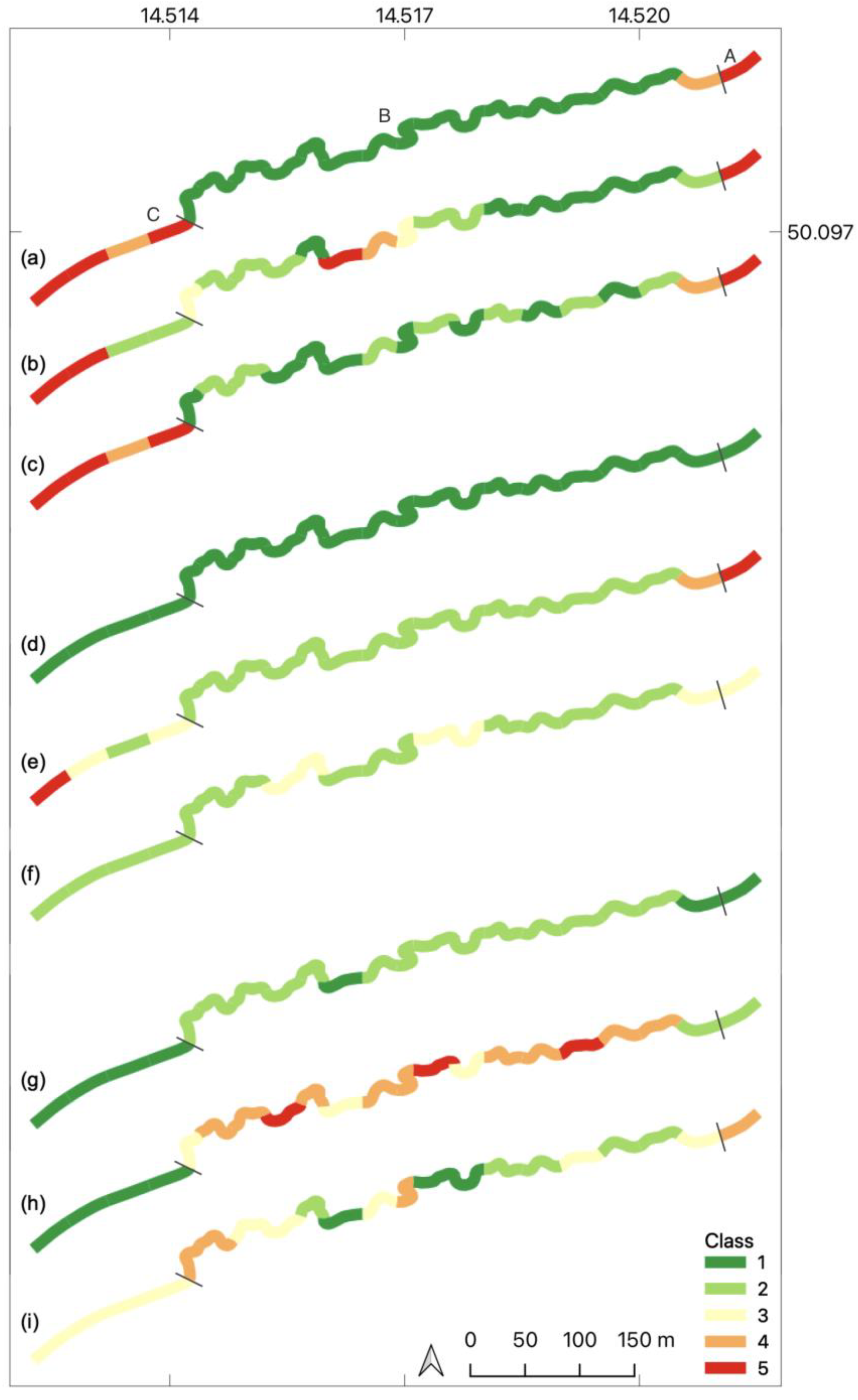
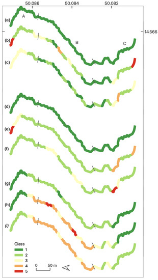
Figure A2.
Assessment of restoration indicators in Hostavický brook (HOS). (a) Channel modifications, (b) Channel stability, (c) Bed variability, (d) Flow continuity, (e) Floodplain connectivity, (f) Water quality, (g) Vegetation coherence, (h) Riparian shading, and (i) Woody debris.
Figure A2.
Assessment of restoration indicators in Hostavický brook (HOS). (a) Channel modifications, (b) Channel stability, (c) Bed variability, (d) Flow continuity, (e) Floodplain connectivity, (f) Water quality, (g) Vegetation coherence, (h) Riparian shading, and (i) Woody debris.
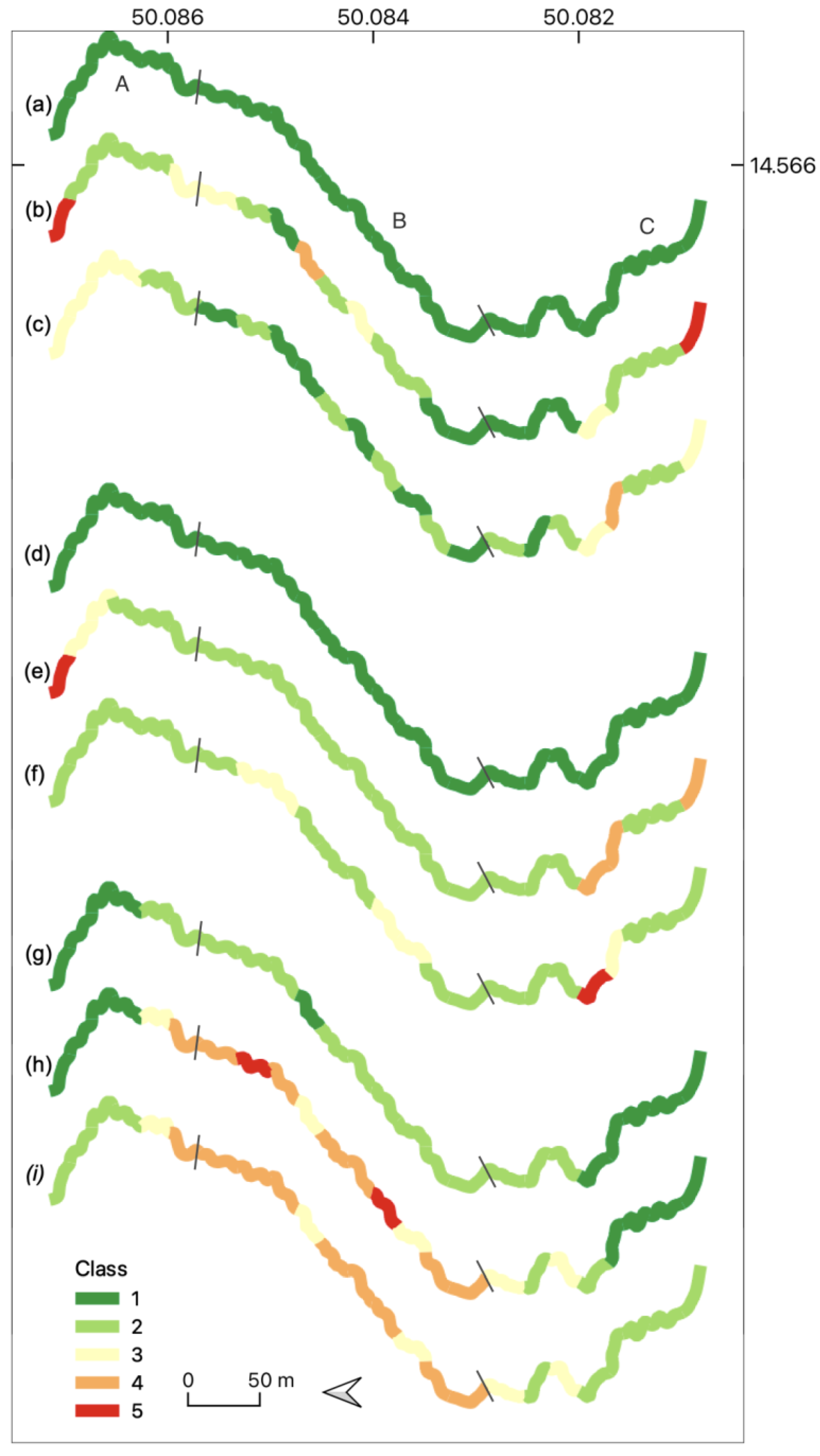
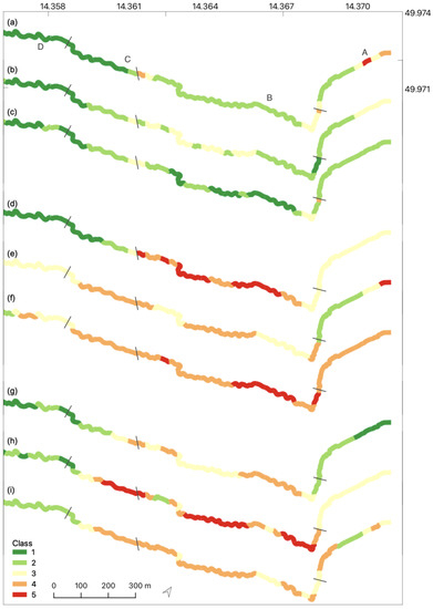
Figure A3.
Assessment of restoration indicators in Lipanský brook (LIP). (a) Channel modifications, (b) Channel stability, (c) Bed variability, (d) Flow continuity, (e) Floodplain connectivity, (f) Water quality, (g) Vegetation coherence, (h) Riparian shading, and (i) Woody debris.
Figure A3.
Assessment of restoration indicators in Lipanský brook (LIP). (a) Channel modifications, (b) Channel stability, (c) Bed variability, (d) Flow continuity, (e) Floodplain connectivity, (f) Water quality, (g) Vegetation coherence, (h) Riparian shading, and (i) Woody debris.
References
- Bash, J.S.; Ryan, C.M. Stream Restoration and Enhancement Projects: Is Anyone Monitoring? Environ. Manag. 2002, 29, 877–885. [Google Scholar] [CrossRef] [PubMed]
- Rosgen, D.L. A Classification of Natural Rivers. Catena 1994, 22, 169–199. [Google Scholar] [CrossRef]
- Church, M.; Ferguson, R.I. Morphodynamics: Rivers beyond Steady State. Water Resour. Res. 2015, 51, 1883–1897. [Google Scholar] [CrossRef]
- Tockner, K.; Lorang, M.S. River Flood Plains Are Model Ecosystems to Test General Hydrogeomorphic and Ecological Concepts. River Res. Appl. 2010, 26, 76–86. [Google Scholar] [CrossRef]
- Miller Dale, E.; Skidmore Peter, B. Natural Channel Design: How Does Rosgen Classification-Based Design Compare with Other Methods? In Proceedings of the Wetlands Engineering & River Restoration Conference 2001, Reno, NV, USA, 27–31 August 2001; American Society of Civil Engineers: Reston, VA, USA, 2001; pp. 1–10. [Google Scholar]
- Simon, A.; Doyle, M.; Kondolf, M.; Shields, F.D., Jr.; Rhoads, B.; Grant, G.; Fitzpatrick, F.; Juracek, K.; McPhillips, M.; MacBroom, J. How Well Do the Rosgen Classification and Associatedc’’Natural Channel Design’’cMethods Integrate and Quantify Fluvial Processes and Channel Response? In Impacts of Global Climate Change, Proceedings of the World Water and Environmental Resources Congress 2005, Anchorage, AK, USA, 15–19 May 2005; American Society of Civil Engineers: Reston, VA, USA, 2005; pp. 1–12. Available online: www.ascelibrary.org (accessed on 20 October 2022).
- Bernhardt, E.S.; Palmer, M.A. Restoring Streams in an Urbanizing World. Freshw. Biol. 2007, 52, 738–751. [Google Scholar] [CrossRef]
- Langhammer, J. UAV Monitoring of Stream Restorations. Hydrology 2019, 6, 29. [Google Scholar] [CrossRef]
- Alexander, G.G.; Allan, J.D. Ecological Success in Stream Restoration: Case Studies from the Midwestern United States. Environ. Manag. 2007, 40, 245–255. [Google Scholar] [CrossRef]
- Rubin, Z.; Kondolf, G.; Rios-Touma, B. Evaluating Stream Restoration Projects: What Do We Learn from Monitoring? Water 2017, 9, 174. [Google Scholar] [CrossRef]
- Woolsey, S.; Capelli, F.; Gonser, T.; Hoehn, E.; Peter, A. A Strategy to Assess River Restoration Success. Freshw. Biol. 2007, 52, 752. [Google Scholar] [CrossRef]
- Bjorkland, R.; Pringle, C.M.; Newton, B. A Stream Visual Assessment Protocol (SVAP) for Riparian Landowners. Environ. Monit. Assess. 2001, 68, 99–125. [Google Scholar] [CrossRef]
- Evans, A.D.; Gardner, K.H.; Greenwood, S. Exploring the Utility of Small Unmanned Aerial System (SUAS) Products in Remote Visual Stream Ecological Assessment. Restoration 2020, 28, 1431–1444. [Google Scholar] [CrossRef]
- Rufino, G.; Moccia, A. Integrated VIS-NIR Hyperspectral / Thermal-IR Electro-Optical Payload System for a Mini-UAV. In Infotech@Aerospace, Proceedings of the Infotech@Aerospace Conferences; American Institute of Aeronautics and Astronautics, Arlington, VA, USA, 26–29 September 2005; Aerospace Research Center: Columbus, OH, USA, 2005. [Google Scholar]
- Johnson, K.; Nissen, E.; Saripalli, S.; Ramón Arrowsmith, J.; McGarey, P.; Scharer, K.; Williams, P.; Blisniuk, K. Rapid Mapping of Ultrafine Fault Zone Topography with Structure from Motion. Geosphere 2014, 10, 969–986. [Google Scholar] [CrossRef]
- Puliti, S.; Ørka, H.O.; Gobakken, T.; Næsset, E. Inventory of Small Forest Areas Using an Unmanned Aerial System. Remote Sens. 2015, 7, 9632–9654. [Google Scholar] [CrossRef]
- Gioia, D.; Minervino Amodio, A.; Maggio, A.; Sabia, C.A. Impact of Land Use Changes on the Erosion Processes of a Degraded Rural Landscape: An Analysis Based on High-Resolution DEMs, Historical Images, and Soil Erosion Models. Land 2021, 10, 673. [Google Scholar] [CrossRef]
- Vilbig, J.M.; Sagan, V.; Bodine, C. Archaeological Surveying with Airborne LiDAR and UAV Photogrammetry: A Comparative Analysis at Cahokia Mounds. J. Archaeol. Sci. Rep. 2020, 33, 102509. [Google Scholar] [CrossRef]
- Ouédraogo, M.M.; Degré, A.; Debouche, C.; Lisein, J. The Evaluation of Unmanned Aerial System-Based Photogrammetry and Terrestrial Laser Scanning to Generate DEMs of Agricultural Watersheds. Geomorphology 2014, 214, 339–355. [Google Scholar] [CrossRef]
- Özcan, O.; Akay, S.S. Modeling Morphodynamic Processes in Meandering Rivers with UAV-Based Measurements. In Proceedings of the IGARSS 2018–2018 IEEE International Geoscience and Remote Sensing Symposium, Valencia, Spain, 22–27 July 2018; pp. 7886–7889. [Google Scholar]
- Dufour, S.; Bernez, I.; Betbeder, J.; Corgne, S.; Hubert-Moy, L.; Nabucet, J.; Rapinel, S.; Sawtschuk, J.; Trollé, C. Monitoring Restored Riparian Vegetation: How Can Recent Developments in Remote Sensing Sciences Help? Knowl. Manag. Aquat. Ecosyst. 2013, 410, 10. [Google Scholar] [CrossRef]
- Hemmelder, S.; Marra, W.; Markies, H.; De Jong, S.M. Monitoring River Morphology & Bank Erosion Using UAV Imagery—A Case Study of the River Buëch, Hautes-Alpes, France. Int. J. Appl. Earth Obs. Geoinf. 2018, 73, 428–437. [Google Scholar]
- Rusnák, M.; Sládek, J.; Kidová, A.; Lehotský, M. Template for High-Resolution River Landscape Mapping Using UAV Technology. Measurement 2018, 2018, 139–151. [Google Scholar] [CrossRef]
- Watanabe, Y.; Kawahara, Y. UAV Photogrammetry for Monitoring Changes in River Topography and Vegetation. Procedia Eng. 2016, 154, 317–325. [Google Scholar] [CrossRef]
- Tamminga, A. UAV-Based Remote Sensing of Fluvial Hydrogeomorphology and Aquatic Habitat Dynamics. Ph.D. Thesis, University of British Columbia, Vancouver, BC, Canada, 2016. [Google Scholar]
- Milani, G.; Volpi, M.; Tonolla, D.; Doering, M.; Robinson, C.; Kneubühler, M.; Schaepman, M. Robust Quantification of Riverine Land Cover Dynamics by High-Resolution Remote Sensing. Remote Sens. Environ. 2018, 217, 491–505. [Google Scholar] [CrossRef]
- Resop, J.P.; Lehmann, L.; Hession, W.C. Drone Laser Scanning for Modeling Riverscape Topography and Vegetation: Comparison with Traditional Aerial Lidar. Drones 2019, 3, 35. [Google Scholar] [CrossRef]
- Lin, Y.; Hyyppä, J.; Jaakkola, A. Mini-UAV-Borne LIDAR for Fine-Scale Mapping. IEEE Geosci. Remote Sens. Lett. 2011, 8, 426–430. [Google Scholar] [CrossRef]
- Lejot, J.; Delacourt, C.; Piégay, H.; Fournier, T.; Trémélo, M.-L.; Allemand, P. Very High Spatial Resolution Imagery for Channel Bathymetry and Topography from an Unmanned Mapping Controlled Platform. Earth Surf. Process. Landf. 2007, 32, 1705–1725. [Google Scholar] [CrossRef]
- Carrivick, J.L.; Smith, M.W. Fluvial and Aquatic Applications of Structure from Motion Photogrammetry and Unmanned Aerial Vehicle/Drone Technology. WIREs Water 2019, 6, e1328. [Google Scholar] [CrossRef]
- Fonstad, M.A.; Dietrich, J.T.; Courville, B.C.; Jensen, J.L.; Carbonneau, P.E. Topographic Structure from Motion: A New Development in Photogrammetric Measurement. Earth Surf. Process. Landf. 2013, 38, 421–430. [Google Scholar] [CrossRef]
- Smith, M.W.; Vericat, D. From Experimental Plots to Experimental Landscapes: Topography, Erosion and Deposition in Sub-Humid Badlands from Structure-from-Motion Photogrammetry. Earth Surf. Process. Landf. 2015, 40, 1656–1671. [Google Scholar] [CrossRef]
- James, M.R.; Robson, S.; d’Oleire-Oltmanns, S.; Niethammer, U. Optimising UAV Topographic Surveys Processed with Structure-from-Motion: Ground Control Quality, Quantity and Bundle Adjustment. Geomorphology 2017, 280, 51–66. [Google Scholar] [CrossRef]
- Hamshaw, S.D.; Bryce, T.; Rizzo, D.M.; O’Neil-Dunne, J.; Frolik, J.; Dewoolkar, M.M. Quantifying Streambank Movement and Topography Using Unmanned Aircraft System Photogrammetry with Comparison to Terrestrial Laser Scanning. River Res. Appl. 2017, 33, 1233–1373. [Google Scholar] [CrossRef]
- Marteau, B.; Vericat, D.; Gibbins, C.; Batalla, R.J.; Green, D.R. Application of Structure-from-Motion Photogrammetry to River Restoration. Earth Surf. Process. Landf. 2017, 42, 503–515. [Google Scholar] [CrossRef]
- Cook, K.L. An Evaluation of the Effectiveness of Low-Cost UAVs and Structure from Motion for Geomorphic Change Detection. Geomorphology 2017, 278, 195–208. [Google Scholar] [CrossRef]
- Dietrich, J.T. Bathymetric Structure-from-motion: Extracting Shallow Stream Bathymetry from Multi-view Stereo Photogrammetry. Earth Surf. Process. Landf. 2017, 42, 355–364. [Google Scholar] [CrossRef]
- James, J.S. Three-Dimensional Reconstruction of Braided River Morphology and Morphodynamics with Structure-from-Motion Photogrammetry. Ph.D. Thesis, Queen Mary University of London, London, UK, 2018. [Google Scholar]
- Clapuyt, F.; Vanacker, V.; Van Oost, K. Reproducibility of UAV-Based Earth Topography Reconstructions Based on Structure-from-Motion Algorithms. Geomorphology 2016, 260, 4–15. [Google Scholar] [CrossRef]
- Cháb, J.; Stráník, Z.; Eliáš, M. Geological Map of the Czech Republic 1:500,000; Czech Geological Survey: Prague, Czech Republic, 2007. [Google Scholar]
- CUZK DMR 5G; Digital Terrain Model of the Czech Republic of the 5th generation (DMR 5G). Czech Office for Surveying, Mapping and Cadastre: Prague, Czech Republic, 2016.
- IPR Prague Prague Geoportal. Available online: https://www.geoportalpraha.cz/en (accessed on 27 January 2021).
- Henne, S.K. “New Wilderness” as an Element of the Peri-Urban Landscape. In Wild Urban Woodlands; Springer: Berlin/Heidelberg, Germany, 2005; pp. 247–262. ISBN 9783540239123. [Google Scholar]
- Prague City Hall Prague’s Nature. Available online: http://www.praha-priroda.cz/ (accessed on 22 January 2021).
- Turner, D.; Lucieer, A.; Watson, C. An Automated Technique for Generating Georectified Mosaics from Ultra-High Resolution Unmanned Aerial Vehicle (UAV) Imagery, Based on Structure from Motion (SfM) Point Clouds. Remote Sens. 2012, 4, 1392–1410. [Google Scholar] [CrossRef]
- van Rees, E. Creating Aerial Drone Maps Fast. GeoInformatics 2015, 18, 24–25. [Google Scholar]
- Visser, F.; Woodget, A.; Skellern, A.; Forsey, J.; Warburton, J.; Johnson, R. An Evaluation of a Low-Cost Pole Aerial Photography (PAP) and Structure from Motion (SfM) Approach for Topographic Surveying of Small Rivers. Int. J. Remote Sens. 2019, 40, 9321–9351. [Google Scholar] [CrossRef]
- Langhammer, J.; Vacková, T. Detection and Mapping of the Geomorphic Effects of Flooding Using UAV Photogrammetry. Pure Appl. Geophys. 2018, 175, 3223–3245. [Google Scholar] [CrossRef]
- Vuv Digital Database of Water Management Data. Digital Water Management Map; VUV TGM: Prague, Czech Republic, 2010. [Google Scholar]
- Conrad, O.; Bechtel, B.; Bock, M.; Dietrich, H.; Fischer, E.; Gerlitz, L.; Wehberg, J.; Wichmann, V.; Böhner, J. System for Automated Geoscientific Analyses (SAGA) v. 2.1.4. Geosci. Model Dev. 2015, 8, 1991–2007. [Google Scholar] [CrossRef]
- Woodget, A.S.; Carbonneau, P.E.; Visser, F.; Maddock, I.P. Quantifying Submerged Fluvial Topography Using Hyperspatial Resolution UAS Imagery and Structure from Motion Photogrammetry. Earth Surf. Process. Landf. 2015, 40, 47–64. [Google Scholar] [CrossRef]
- Langhammer, J.; Lendzioch, T.; Miřijovský, J.; Hartvich, F. UAV-Based Optical Granulometry as Tool for Detecting Changes in Structure of Flood Depositions. Remote Sens. 2017, 9, 240. [Google Scholar] [CrossRef]
- Michez, A.; Piégay, H.; Lisein, J.; Claessens, H.; Lejeune, P. Classification of Riparian Forest Species and Health Condition Using Multi-Temporal and Hyperspatial Imagery from Unmanned Aerial System. Environ. Monit. Assess. 2016, 188, 146. [Google Scholar] [CrossRef] [PubMed]
- MacVicar, B.J.; Piégay, H.; Henderson, A.; Comiti, F.; Oberlin, C.; Pecorari, E. Quantifying the Temporal Dynamics of Wood in Large Rivers: Field Trials of Wood Surveying, Dating, Tracking, and Monitoring Techniques. Earth Surf. Process. Landf. 2009, 34, 2031–2046. [Google Scholar] [CrossRef]
- Casado, M.R.; Gonzalez, R.B.; Kriechbaumer, T.; Veal, A. Automated Identification of River Hydromorphological Features Using UAV High Resolution Aerial Imagery. Sensors 2015, 15, 27969–27989. [Google Scholar] [CrossRef] [PubMed]
- Duró, G.; Crosato, A.; Kleinhans, M.G.; Uijttewaal, W.S.J. Bank Erosion Processes Measured with UAV-SfM along Complex Banklines of a Straight Mid-Sized River Reach. Earth Surf. Dynam. 2018, 6, 933–953. [Google Scholar] [CrossRef]
- de Castro, A.I.; Shi, Y.; Maja, J.M.; Peña, J.M. UAVs for Vegetation Monitoring: Overview and Recent Scientific Contributions. Remote Sens. 2021, 13, 2139. [Google Scholar] [CrossRef]
- CEN EN 14614:2004; Water Quality. Guidance Standard for Assessing the Hydromorphological Features of River. CEN: Brussels, Belgium, 2004.
- CEN EN 15843:2010; Water Quality. Guidance Standard on Determining the Degree of Modification of River Hydromorphology. CEN: Brussels, Belgium, 2010.
- Pander, J.; Geist, J. Ecological Indicators for Stream Restoration Success. Ecol. Indic. 2013, 30, 106–118. [Google Scholar] [CrossRef]
- Langhammer, J. HEM 2014—Methodology of Monitoring of Hydromorphological Indicators of Ecological Quality of Waterbodies; Ministry of the Environment of the Czech Republic: Prague, Czech Republic, 2014; p. 71. [Google Scholar]
- European Parliament. EC Directive 2000/60/EC of the European Parliament and of the Council of 23 October 2000 Establishing a Framework for Community Action in the Field of Water Policy. Off. J. Eur. Communities 2000, L327, 1–73. [Google Scholar]
- Bernhardt, E.S.; Palmer, M.A.; Allan, J.D.; Alexander, G.; Barnas, K.; Brooks, S.; Carr, J.; Clayton, S.; Dahm, C.; Follstad-Shah, J.; et al. Ecology. Synthesizing, U.S. River Restoration Efforts. Science 2005, 308, 636–637. [Google Scholar] [CrossRef]
- Rusnák, M.; Sládek, J.; Pacina, J.; Kidová, A. Monitoring of Avulsion Channel Evolution and River Morphology Changes Using UAV Photogrammetry: Case Study of the Gravel Bed Ondava River in Outer Western Carpathians. Area 2018, 48, 74. [Google Scholar] [CrossRef]
- Toro, F.G.; Tsourdos, A. UAV Sensors for Environmental Monitoring; MDPI: Basel, Switzerland, 2018; ISBN 9783038427537. [Google Scholar]
- Leng, G.; Qian, Z.; Govindaraju, V. Multi-UAV Surveillance over Forested Regions. Photogramm. Eng. Remote Sens. 2014, 80, 1129–1137. [Google Scholar] [CrossRef]
- Griffith, M.B.; McManus, M.G. Consideration of Spatial and Temporal Scales in Stream Restorations and Biotic Monitoring to Assess Restoration Outcomes: A Literature Review, Part 1. River Res. Appl. 2020, 36, 1385–1397. [Google Scholar] [CrossRef]


Disclaimer/Publisher’s Note: The statements, opinions and data contained in all publications are solely those of the individual author(s) and contributor(s) and not of MDPI and/or the editor(s). MDPI and/or the editor(s) disclaim responsibility for any injury to people or property resulting from any ideas, methods, instructions or products referred to in the content. |
© 2023 by the authors. Licensee MDPI, Basel, Switzerland. This article is an open access article distributed under the terms and conditions of the Creative Commons Attribution (CC BY) license (https://creativecommons.org/licenses/by/4.0/).