From Catchment to National Scale Rainfall-Runoff Modelling: Demonstration of a Hydrological Modelling Framework

Abstract
:1. Introduction
2. Background and Methodology
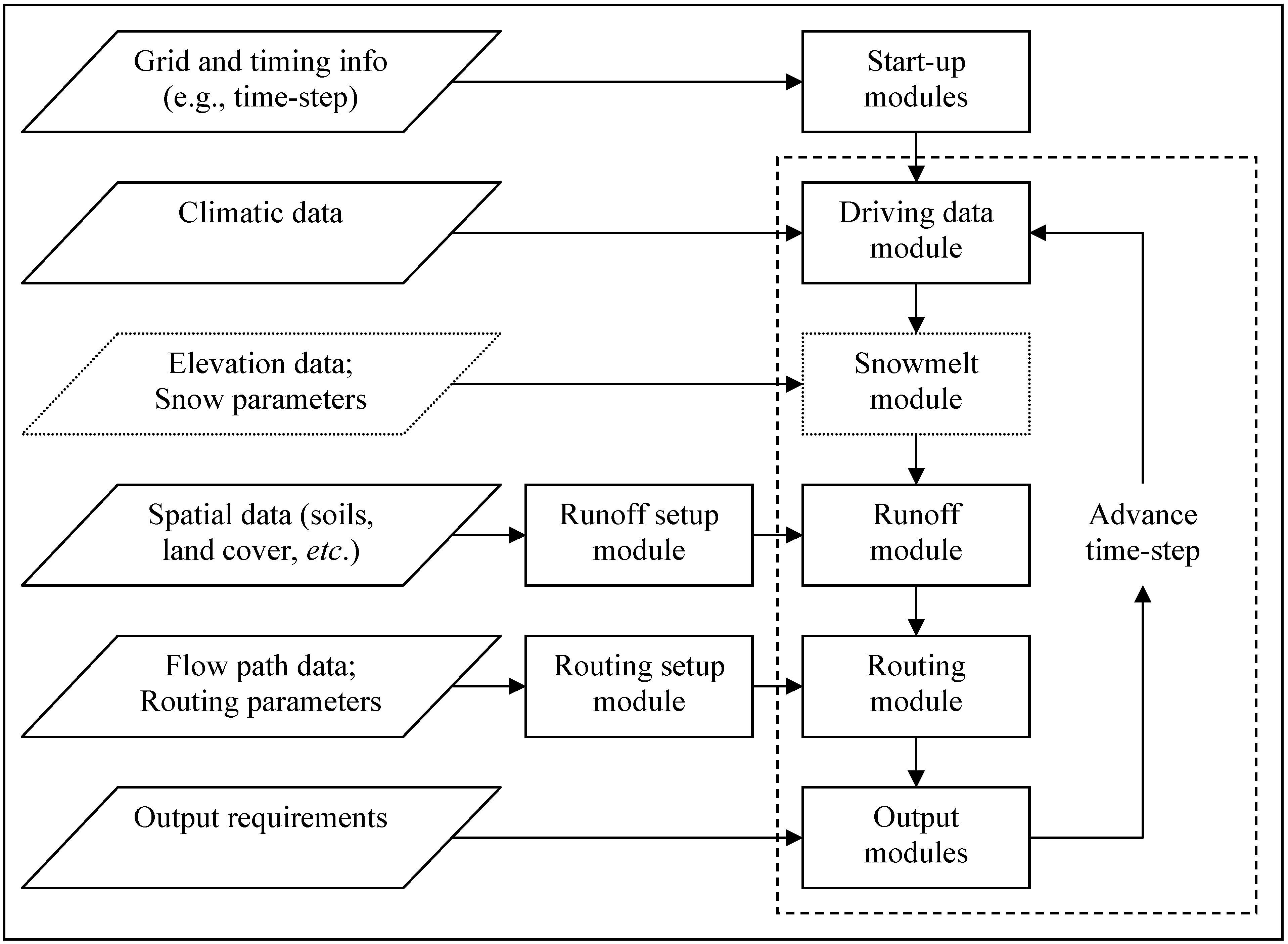
2.1. Description of the Hydrological Modelling Framework

2.2. Background on CLASSIC
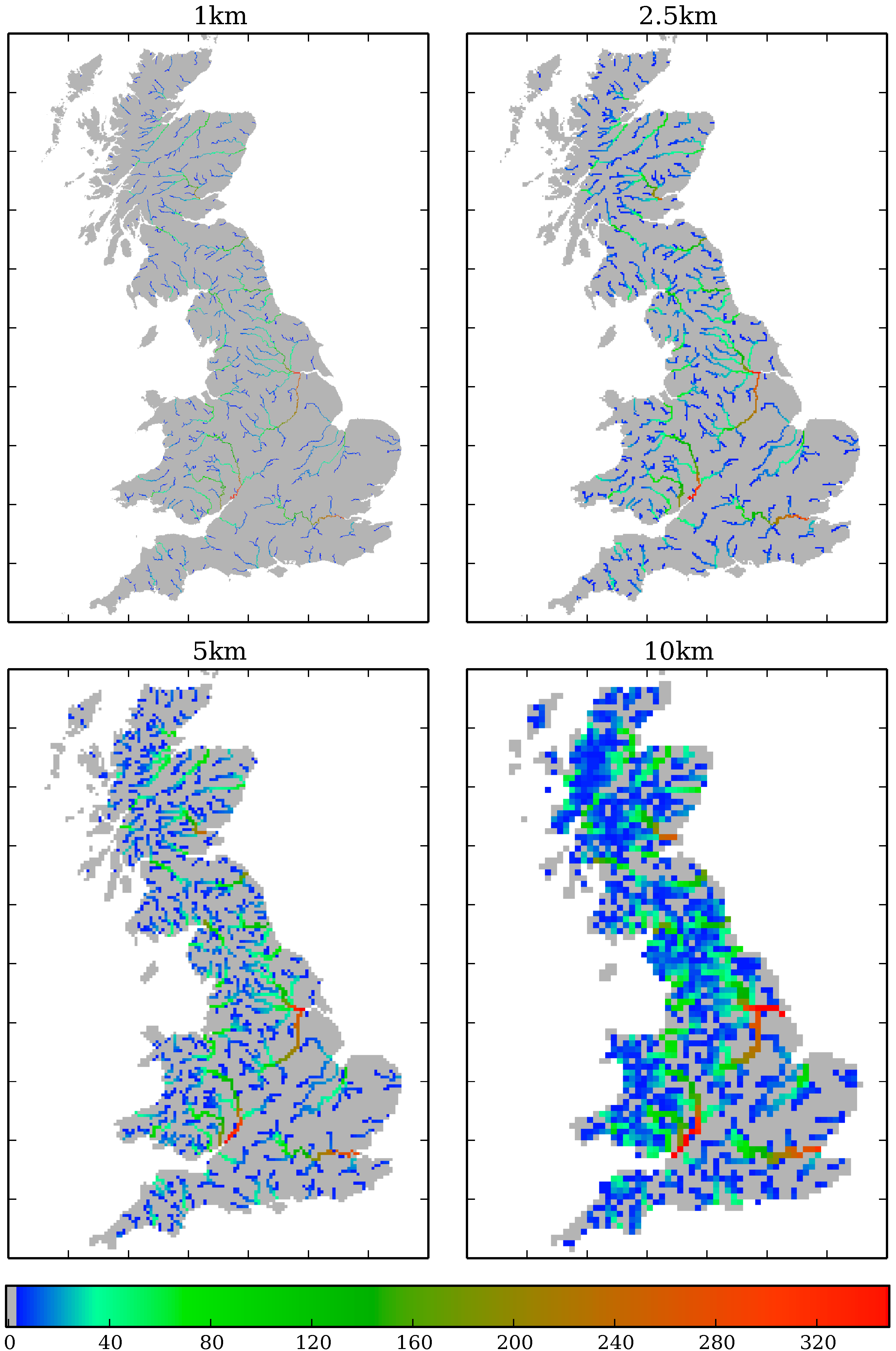
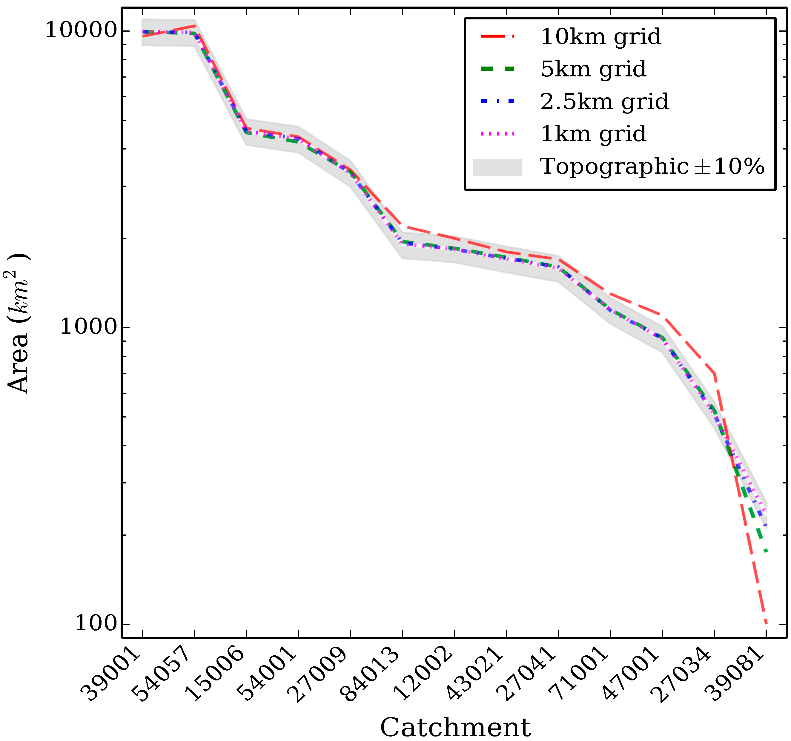
2.3. Setting up CLASSIC-GB
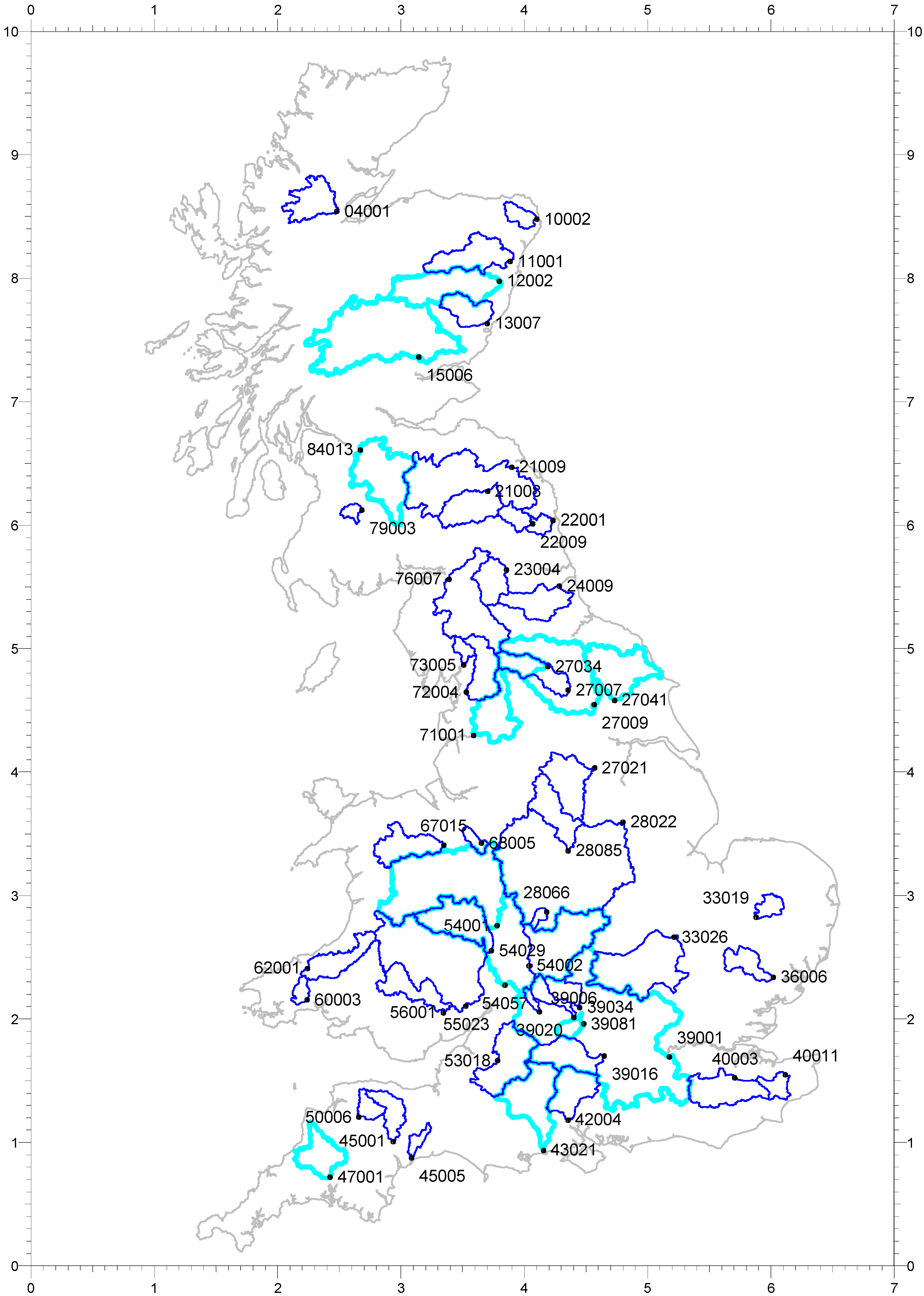
2.4. Catchments

| Station Number | River | Area (km2) | SAAR61–90 (mm) | Altituderange (m) | BFI | HOST |
|---|---|---|---|---|---|---|
| 12002 | Dee @ Park1 | 1844 | 1081 | 23–1309 | 0.53 | 17, 15, 29 |
| 15006 | Tay @ Ballathie1 | 4587 | 1425 | 26–1210 | 0.64 | 17, 15 |
| 27009 | Ouse @ Skelton1 | 3315 | 900 | 5–714 | 0.39 | 24, 29, 26 |
| 27034 | Ure @ Kilgram1 | 510 | 1342 | 88–710 | 0.32 | 29, 26, 6 |
| 27041 | Derwent @ Buttercrambe1 | 1586 | 765 | 10–452 | 0.69 | 24, 4, 2 |
| 39001 | Thames @ Kingston1 | 9948 | 706 | 5–330 | 0.63 | 25, 1, 2 |
| 39081 | Ock @ Abingdon1 | 234 | 639 | 51–260 | 0.64 | 25, 2, 3 |
| 43021 | Avon @ Knapp Mill1 | 1706 | 810 | 1–294 | 0.86 | 1 |
| 47001 | Tamar @ Gunnislake1 | 917 | 1216 | 8–580 | 0.46 | 17, 24, 21 |
| 54001 | Severn @ Bewdley1 | 4325 | 913 | 17–826 | 0.53 | 24, 17, 18 |
| 54057 | Severn @ Haw Bridge1 | 9895 | 792 | 11–826 | 0.56 | 24, 18 |
| 71001 | Ribble @ Samlesbury1 | 1145 | 1353 | 10–688 | 0.33 | 24, 26, 29 |
| 84013 | Clyde @ Daldowie1 | 1903 | 1129 | 8–745 | 0.46 | 24, 15, 29 |
| 04001 | Conon @ Moy Bridge | 962 | 1770 | 10–1100 | 0.57 | 15, 19, 29, 12 |
| 10002 | Ugie @ Inverugie | 325 | 812 | 9–234 | 0.63 | 17, 24 |
| 11001 | Don @ Parkhill1 | 1273 | 885 | 32–874 | 0.68 | 17, 15 |
| 13007 | North Esk @ Logie Mill | 732 | 1074 | 11–929 | 0.51 | 15, 18, 17 |
| 21008 | Teviot @ Ormiston Mill | 1110 | 939 | 43–611 | 0.45 | 19, 6, 15, 24, 17 |
| 21009 | Tweed @ Norham1 | 4390 | 955 | 4–838 | 0.52 | 17, 15, 24 |
| 22001 | Coquet @ Morwick | 570 | 850 | 5–775 | 0.44 | 24, 15 |
| 22009 | Coquet @ Rothbury | 346 | 905 | 71–775 | 0.48 | 24, 29, 15, 19 |
| 23004 | South Tyne @ Haydon Bridge | 751 | 1148 | 59–893 | 0.34 | 24, 29, 26 |
| 24009 | Wear @ Chester le Street1 | 1008 | 885 | 6–745 | 0.46 | 24, 26 |
| 27007 | Ure @ Westwick Lock1 | 915 | 1118 | 14–710 | 0.39 | 24, 26, 29, 6 |
| 27021 | Don @ Doncaster | 1256 | 799 | 4–543 | 0.56 | 24, 4 |
| 28022 | Trent @ North Muskham1 | 8231 | 747 | 5–634 | 0.65 | 24, 21 |
| 28066 | Cole @ Coleshill | 130 | 722 | 79–202 | 0.42 | 24, 21 |
| 28085 | Derwent @ St Mary’s Bridge | 1054 | 1012 | 44–634 | 0.63 | 4, 24, 15 |
| 33019 | Thet @ Melford Bridge | 316 | 620 | 11–71 | 0.78 | 1, 24, 5, 18 |
| 33026 | Bedford Ouse @ Offord1 | 2570 | 609 | 11–247 | 0.50 | 21, 23, 25 |
| 36006 | Stour @ Langham | 578 | 580 | 6–128 | 0.52 | 21, 5 |
| 39006 | Windrush @ Newbridge | 363 | 743 | 63–317 | 0.86 | 2, 23 |
| 39016 | Kennet @ Theale1 | 1038 | 759 | 43–296 | 0.88 | 1, 25, 18 |
| 39020 | Coln @ Bibury | 107 | 820 | 101–330 | 0.93 | 2, 23 |
| 39034 | Evenlode @ Cassington Mill1 | 430 | 691 | 60–267 | 0.71 | 2, 25 |
| 40003 | Medway @ Teston1 | 1256 | 744 | 7–268 | 0.40 | 25, 18, 24 |
| 40011 | Great Stour @ Horton | 345 | 747 | 13–196 | 0.69 | 1, 18, 25, 3 |
| 42004 | Test @ Broadlands | 1040 | 790 | 10–296 | 0.94 | 1, 6 |
| 45001 | Exe @ Thorveton | 601 | 1295 | 26–514 | 0.50 | 17 |
| 45005 | Otter @ Dotton | 202 | 976 | 15–302 | 0.53 | 21, 3, 24 |
| 50006 | Mole @ Woodleigh | 327 | 1307 | 48–490 | 0.47 | 17, 24 |
| 53018 | Avon @ Bathford1 | 1552 | 817 | 18–304 | 0.57 | 2, 25, 23 |
| 54002 | Avon @ Evesham | 2210 | 654 | 20–317 | 0.52 | 25, 24, 21, 23 |
| 54029 | Teme @ Knightsford Bridge | 1480 | 818 | 21–545 | 0.55 | 18, 4 |
| 55023 | Wye @ Redbrook1 | 4010 | 1011 | 9–749 | 0.54 | 18, 17, 24 |
| 56001 | Usk @ Chain Bridge | 912 | 1363 | 23–885 | 0.50 | 4, 17, 15, 5, 26 |
| 60003 | Taf @ Clog-y-Fran | 217 | 1420 | 9–392 | 0.55 | 17 |
| 62001 | Teifi @ Glan Teifi1 | 894 | 1382 | 66–592 | 0.54 | 17, 24 |
| 67015 | Dee @ Manley Hall | 1013 | 1369 | 25–878 | 0.54 | 17, 15, 24, 29 |
| 68005 | Weaver @ Audlem | 207 | 719 | 45–221 | 0.54 | 24, 18, 5, 10 |
| 72004 | Lune @ Caton1 | 983 | 1523 | 11–734 | 0.32 | 29, 24, 26, 15 |
| 73005 | Kent @ Sedgwick | 209 | 1732 | 19–812 | 0.41 | 17, 29 |
| 76007 | Eden @ Sheepmount1 | 2286 | 1183 | 10–945 | 0.49 | 24, 5, 29 |
| 79003 | Nith @ Hall Bridge | 155 | 1505 | 173–607 | 0.27 | 24, 15, 29 |

2.5. Model Assessment Methods

| Band | NS | Bias (%) | mmfd |
|---|---|---|---|
| 1 | NS ≥ 0.8 | −10 ≤ Bias ≤ 10 | mmfd ≤ 20 |
| 2 | 0.6 ≤ NS< 0.8 | −20 ≤ Bias < −10 or 10 < Bias ≤ 20 | 20 < mmfd ≤ 40 |
| 3 | NS < 0.6 | Bias < −20 or Bias > 20 | mmfd > 40 |
3. Results and Discussion
3.1. Initial Results
| Station Number | 10 km | 5 km | 2.5 km | 1 km | CLASSIC-Catchment | |||||
|---|---|---|---|---|---|---|---|---|---|---|
| NS | Bias | NS | Bias | NS | Bias | NS | Bias | NS | Bias | |
| 39081 | N/A | N/A | 0.68 | −33.5 | 0.78 | −23.4 | 0.80 | −13.6 | 0.79 | 5.7 |
| 27034 | 0.39 | 44.5 | 0.78 | −5.5 | 0.72 | 1.5 | 0.78 | 2.8 | 0.59 | 2.8 |
| 47001 | 0.69 | 32.0 | 0.83 | 2.3 | 0.83 | −0.4 | 0.82 | 0.6 | 0.80 | 0.3 |
| 71001 | 0.71 | 18.1 | 0.79 | 2.5 | 0.70 | 0.0 | 0.73 | 0.4 | 0.64 | 4.7 |
| 27041 | 0.74 | −8.2 | 0.66 | −7.1 | 0.66 | −4.9 | 0.65 | −5.3 | 0.93 | 3.4 |
| 43021 | 0.68 | −10.9 | 0.63 | −15.6 | 0.63 | −16.8 | 0.60 | −17.6 | 0.89 | −10.1 |
| 12002 | 0.64 | 2.2 | 0.63 | −6.7 | 0.57 | −3.4 | 0.55 | −3.4 | 0.74 | -2.3 |
| 84013 | 0.82 | 7.1 | 0.79 | −1.3 | 0.79 | − 1.3 | 0.80 | −2.5 | 0.85 | −1.3 |
| 27009 | 0.81 | 9.5 | 0.83 | −4.7 | 0.76 | 4.2 | 0.80 | 3.1 | 0.92 | 8.6 |
| 54001 | 0.72 | 10.7 | 0.77 | −2.2 | 0.66 | 5.8 | 0.66 | 4.6 | 0.90 | 11.3 |
| 15006 | 0.50 | −7.7 | 0.50 | −9.4 | 0.48 | −7.5 | 0.46 | −7.7 | 0.85 | −7.4 |
| 54057 | 0.74 | 9.7 | 0.81 | −1.5 | 0.78 | 2.8 | 0.78 | 2.1 | 0.85 | 6.0 |
| 39001 | 0.84 | −7.4 | 0.82 | −4.6 | 0.81 | −5.9 | 0.81 | −5.9 | 0.96 | −0.9 |
| Average* | 0.69 | 8.3 | 0.74 | −4.5 | 0.70 | −2.2 | 0.70 | −2.4 | 0.82 | 1.3 |

3.2. Development of CLASSIC-GB
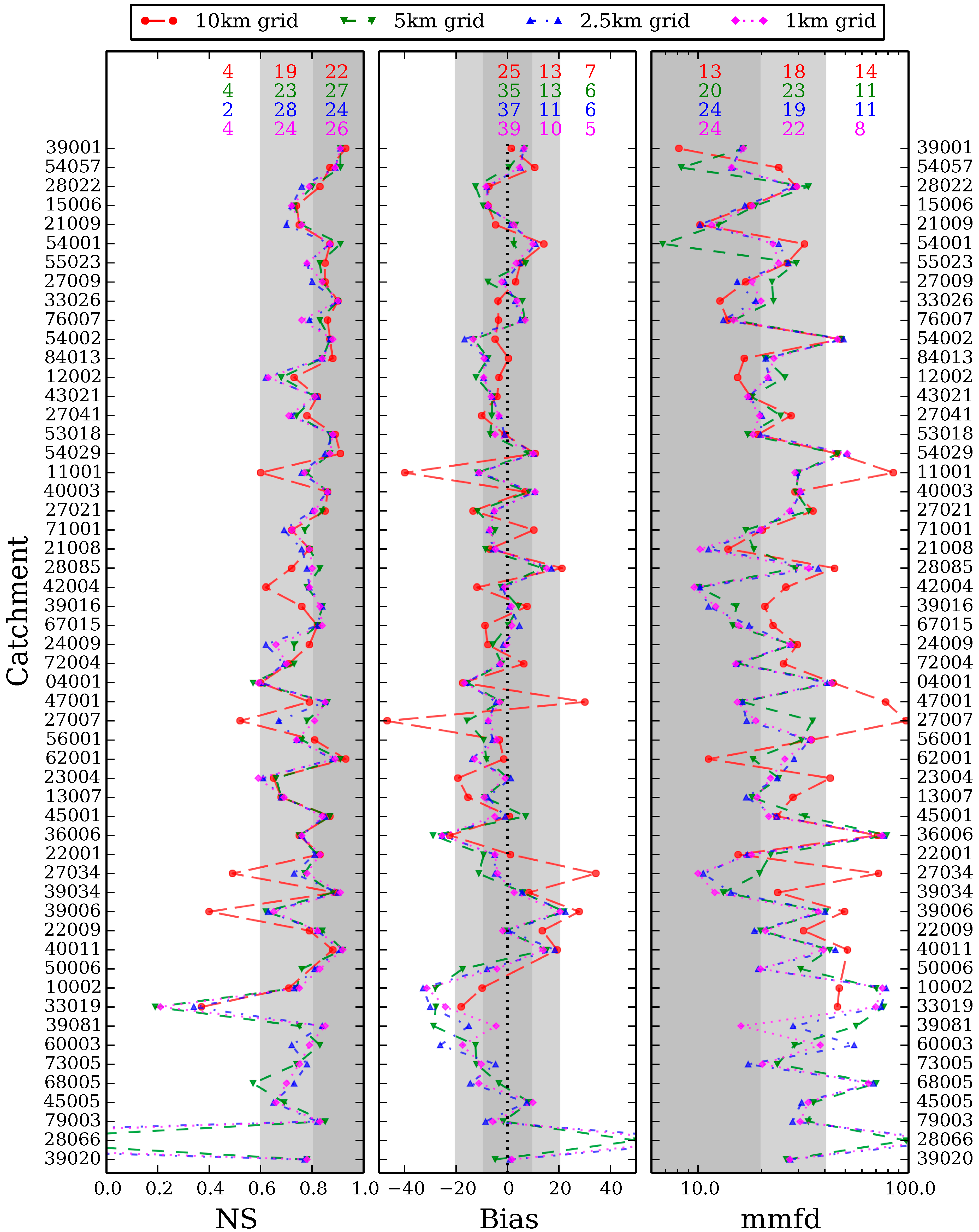
3.3. Final Results


3.4. Discussion
| Number of Catchments | 10 km | 5 km | 2.5 km | 1 km | |||||||||
|---|---|---|---|---|---|---|---|---|---|---|---|---|---|
| NS | Bias | mmfd | NS | Bias | mmfd | NS | Bias | mmfd | NS | Bias | mmfd | ||
| Overall | 0.77 | −1.3 | 33.3 | 0.78 | −4.7 | 28.9 | 0.77 | −3.6 | 27.7 | 0.78 | −3.3 | 26.8 | |
| Area (km2) | |||||||||||||
| < 350 | 12 | N/A | N/A | N/A | 0.72 | −9.5 | 42.7 | 0.74 | −9.4 | 40.8 | 0.74 | −7.1 | 37.9 |
| 350–999 | 14 | 0.71 | −1.2 | 44.0 | 0.76 | −5.5 | 29.1 | 0.74 | −4.7 | 26.7 | 0.76 | −5.2 | 26.3 |
| 1000–1999 | 15 | 0.78 | −3.3 | 30.2 | 0.80 | −2.8 | 23.8 | 0.77 | −0.6 | 23.5 | 0.78 | −0.9 | 22.9 |
| ≥ 2000 | 12 | 0.85 | 0.3 | 21.3 | 0.84 | −1.5 | 21.2 | 0.82 | −0.4 | 21.2 | 0.83 | −0.3 | 21.5 |
| SAAR61–90 (mm) | |||||||||||||
| 580–749 | 12 | 0.77 | 0.8 | 36.8 | 0.75 | −4.2 | 43.9 | 0.78 | −3.6 | 40.7 | 0.78 | −2.4 | 38.0 |
| 750–949 | 16 | 0.79 | −3.1 | 31.4 | 0.82 | −5.4 | 24.7 | 0.80 | −2.8 | 25.3 | 0.80 | −3.0 | 25.0 |
| 950–1299 | 12 | 0.75 | −3.2 | 36.0 | 0.78 | −0.1 | 24.4 | 0.74 | −0.1 | 21.5 | 0.75 | −0.5 | 21.6 |
| ≥ 1300 | 13 | 0.74 | 1.7 | 29.4 | 0.78 | −8.6 | 24.4 | 0.75 | −7.9 | 24.5 | 0.77 | −7.1 | 23.7 |
| BFI | |||||||||||||
| 0.27–0.49 | 17 | 0.75 | 1.6 | 35.9 | 0.79 | −5.5 | 23.0 | 0.76 | −3.1 | 18.9 | 0.78 | −3.0 | 19.7 |
| 0.50–0.59 | 20 | 0.82 | −3.4 | 29.6 | 0.79 | −4.4 | 31.0 | 0.78 | −4.8 | 32.8 | 0.79 | −4.5 | 31.4 |
| ≥ 0.60 | 16 | 0.72 | −1.6 | 35.3 | 0.76 | −4.4 | 32.5 | 0.76 | −2.8 | 30.8 | 0.76 | −2.3 | 28.9 |
| Max altitude (m) | |||||||||||||
| 70–299 | 12 | 0.76 | −2.8 | 34.5 | 0.75 | −7.2 | 41.8 | 0.79 | −7.3 | 39.4 | 0.77 | −6.0 | 36.7 |
| 300–599 | 13 | 0.82 | 5.0 | 33.1 | 0.81 | −1.3 | 28.1 | 0.79 | −1.2 | 28.9 | 0.81 | −0.6 | 27.0 |
| 600–799 | 14 | 0.75 | 2.1 | 33.8 | 0.80 | −4.8 | 24.5 | 0.76 | −2.8 | 21.0 | 0.79 | −2.8 | 21.4 |
| ≥ 800 | 14 | 0.76 | −7.9 | 32.1 | 0.76 | −5.7 | 22.9 | 0.75 | −3.6 | 23.5 | 0.75 | −4.1 | 23.7 |
3.5. Additional Analyses
4. Conclusions
Acknowledgments
Author Contributions
Conflict of Interest
References and Notes
- Todini, E. Hydrological catchment modelling: Past, present and future. Hydrol. Earth Syst. Sci. 2007, 11, 468–482. [Google Scholar] [CrossRef]
- Brath, A.; Montanari, A.; Moretti, G. Assessing the effect on flood frequency of land use change via hydrological simulation. J. Hydrol. 2006, 324, 141–153. [Google Scholar] [CrossRef]
- Bastola, S.; Murphy, C.; Sweeney, J. The sensitivity of fluvial flood risk in Irish catchments to the range of IPCC AR4 climate change scenarios. Sci. Total Environ. 2011, 409, 5403–5415. [Google Scholar] [CrossRef]
- Prudhomme, C.; Wilby, R.L.; Crooks, S.; Kay, A.L.; Reynard, N.S. Scenario-neutral approach to climate change impact studies: Application to flood risk. J. Hydrol. 2010, 390, 198–209. [Google Scholar] [CrossRef]
- Hrachowitz, M.; Savenije, H.H.G.; Blöschl, G.; McDonnell, J.J.; Sivapalan, M.; Pomeroy, J.W.; Arheimer, B.; Blume, T.; Clark, M.P.; Ehret, U.; et al. A decade of Predictions in Ungauged Basins (PUB)—A review. Hydrol. Sci. J. 2013, 58, 1198–1255. [Google Scholar] [CrossRef]
- Mazvimavi, D.; Meijerink, A.M.J.; Stein, A. Prediction of base flows from basin characteristics: A case study from Zimbabwe. Hydrol. Sci. J. 2004, 49, 703–715. [Google Scholar]
- Skaugen, T.; Onof, C. A rainfall-runoff model parameterized from GIS and runoff data. Hydrol. Processes 2014, 28, 4529–4542. [Google Scholar]
- Kay, A.; Jones, D.A.; Crooks, S.M.; Calver, A.; Reynard, N.S. A comparison of three approaches to spatial generalization of rainfall-runoff models. Hydrol. Processes 2006, 20, 3953–3973. [Google Scholar] [CrossRef]
- Young, A.R.; Grew, R.; Keller, V.; Stannett, J.; Allen, S. Estimation of river flow time-series to support water resources management: The CERF model. In Proceedings of Sustainable Hydrology for the 21st Century, 10th British Hydrological Society National Hydrology Symposium, Exeter, UK, 15–17 September 2008; pp. 100–106.
- Wagener, T.; Wheater, H.S. Parameter estimation and regionalization for continuous rainfall–runoff models including uncertainty. J. Hydrol. 2006, 320, 132–154. [Google Scholar] [CrossRef]
- Oudin, L.; Kay, A.; Andréassian, V.; Perrin, C. Are seemingly physically similar catchments truly hydrologically similar? Water Resour. Res. 2010, 46, W11558. [Google Scholar]
- Bell, V.A.; Kay, A.L.; Jones, R.G.; Moore, R.J.; Reynard, N.S. Use of soil data in a grid-based hydrological model to estimate spatial variation in changing flood risk across the UK. J. Hydrol. 2009, 377, 335–350. [Google Scholar] [CrossRef]
- Gudmundsson, L.; Wagner, T.; Tallaksen, L.M; Engeland, K. Evaluation of nine large scale hydrological models with respect to the seasonal runoff climatology in Europe. Water Resour. Res. 2012, 48, W11504. [Google Scholar]
- Wagener, T.; Wheater, H.S.; Gupta, H.V. Rainfall–Runoff Modelling in Gauged and Ungauged Catchments; Imperial College Press: London, UK, 2004. [Google Scholar]
- Clark, M.P.; Slater, A.G.; Rupp, D.E.; Woods, R.A.; Vrugt, J.A.; Gupta, H.V.; Wagener, T.; Hay, L.E. Framework for Understanding Structural Errors (FUSE): A modular framework to diagnose differences between hydrological models. Water Resour. Res. 2008, 44, W00B02. [Google Scholar]
- Crooks, S.M.; Naden, P.S. CLASSIC: A semi-distributed modelling system. Hydrol. Earth Syst. Sci. 2007, 11, 516–531. [Google Scholar]
- Davies, H.N.; Bell, V. Assessment of methods for extracting low resolution river networks from high resolution digital data. Hydrol. Sci. J. 2009, 54, 17–28. [Google Scholar] [CrossRef]
- Bell, V.A.; Kay, A.L.; Jones, R.G.; Moore, R.J. Development of a high resolution grid-based river flow model for use with regional climate model output. Hydrol. Earth Syst. Sci. 2007, 11, 532–549. [Google Scholar] [CrossRef]
- Bell, V.A.; Moore, R.J. An elevation-dependent snowmelt model for upland Britain. Hydrol. Processes 1999, 13, 1887–1903. [Google Scholar] [CrossRef]
- Environment Agency. Continuous Estimation of River Flows (CERF) Technical Report: Estimation of Precipitation Inputs; Project SC030240; Environment Agency: Bristol, UK, 2008. [Google Scholar]
- Hough, M.; Palmer, S.; Weir, A.; Lee, M.; Barrie, I.A. The Meteorological Office Rainfall and Evaporation Calculation System: MORECS Version 2.0 (1995). An Update to Hydrological Memorandum 45; The Met. Office: Bracknell, UK, 1997. [Google Scholar]
- Jenkins, G.J.; Perry, M.C.; Prior, M.J.O. The Climate of the United Kingdom and Recent Trends; Met Office Hadley Centre: Exeter, UK, 2007. [Google Scholar]
- Kay, A.L.; Crooks, S.M. An investigation of the effect of transient climate change on snowmelt, flood frequency and timing in northern Britain. Int. J. Climatol. 2014. [Google Scholar] [CrossRef]
- Boorman, D.B.; Hollis, J.M.; Lilly, A. Hydrology of Soil Types: A Hydrologically Based Classification of Soils in the United Kingdom; IH Report No. 126; Institute of Hydrology: Wallingford, UK, 1995. [Google Scholar]
- Morton, D.; Rowland, C.; Wood, C.; Meek, L.; Marston, C.; Smith, G.; Wadsworth, R.; Simpson, I.C. Final Report for LCM2007—The New UK Land Cover Map; Countryside Survey Technical Report No 11/07; Centre for Ecology & Hydrology: Wallingford, UK, 2011. [Google Scholar]
- Morris, D.G.; Flavin, R.W. A digital terrain model for hydrology. In Proceedings of the 4th International Symposium on Spatial Data Handling, Zurich, Switzerland, 23–27 July 1990; Volume 1, pp. 250–262.
- Fuller, R.M. The land cover map of Great Britain. Earth Sp. Rev. 1993, 2, 13–18. [Google Scholar]
- Fuller, R.M.; Smith, G.M.; Sanderson, J.M.; Hill, R.A.; Thompson, A.G. The UK land-cover map 2000: Construction of a parcel-based vector map from satellite images. Cartogr. J. 2002, 39, 15–25. [Google Scholar] [CrossRef]
- Dunn, S.M.; Lilly, A. Investigating the relationship between a soils classification and the spatial parameters of a conceptual catchment scale hydrological model. J. Hydrol. 2001, 252, 157–173. [Google Scholar] [CrossRef]
- Marechal, D.; Holman, I.P. Development and application of a soil classification based conceptual catchment scale hydrological model. J. Hydrol. 2005, 312, 277–293. [Google Scholar] [CrossRef]
- Crooks, S.; Davies, H. Assessment of land use change in the Thames catchment and its effect on the flood regime of the river. Phys. Chem. Earth 2001, 26, 583–591. [Google Scholar] [CrossRef]
- Kay, A.L.; Crooks, S.M.; Pall, P.; Stone, D. Attribution of Autumn/Winter 2000 flood risk in England to anthropogenic climate change: A catchment-based study. J. Hydrol. 2011, 406, 97–112. [Google Scholar] [CrossRef]
- Prudhomme, C.; Crooks, S.; Kay, A.L.; Reynard, N.S. Climate change and river flooding: Part 1 Classifying the sensitivity of British catchments. Clim. Change 2013, 119, 933–948. [Google Scholar] [CrossRef]
- Kay, A.L.; Crooks, S.M.; Reynard, N.S. Using response surfaces to estimate impacts of climate change on flood peaks: assessment of uncertainty. Hydrol. Processes 2013. [Google Scholar] [CrossRef]
- Prudhomme, C.; Haxton, T.; Crooks, S.; Jackson, C.; Barkwith, A.; Williamson, J.; Kelvin, J.; Mackay, J.; Wang, L.; Young, A.; et al. Future Flows Hydrology: an ensemble of daily river flow and monthly groundwater levels for use for climate change impact assessment across Great Britain. Earth Syst. Sci. Data 2013, 5, 101–107. [Google Scholar] [CrossRef]
- National River Flow Archive. Available online: http://www.ceh.ac.uk/data/nrfa/index.html. (accessed on 4 June 2014).
- UK Hydrometric Register; Hydrological Data UK Series; Marsh, T.J.; Hannford, J. (Eds.) Centre for Ecology & Hydrology: Wallingford, UK, 2008.
- Nash, J.E.; Sutcliffe, J.V. River flow forecasting through conceptual models part 1—A discussion of principles. J. Hydrol. 1970, 10, 282–290. [Google Scholar] [CrossRef]
- Crooks, S.; Young, A.; Jackson, C. Modelling Protocol. Science Report SC090016/PN4. 2012, p. 33. Available online: http://www.ceh.ac.uk/data/nrfa/nhmp/monthly_hs.html (accessed on 4 June 2014).
- Biondi, D.; Freni, G.; Iacobellis, V.; Mascaro, G.; Montanari, A. Validation of hydrological models: Conceptual basis, methodological approaches and a proposal for a code of practice. Phys. Chem. Earth 2012, 42–44, 70–76. [Google Scholar] [CrossRef]
- Hydrological Summaries of the National Hydrological Monitoring Programme. Available online: http://www.ceh.ac.uk/data/nrfa/nhmp/monthly_hs.html (accessed on 4 June 2014).
- Kay, A.L.; Bell, V.A.; Blyth, E.M.; Crooks, S.M.; Davies, H.N. A hydrological perspective on evaporation: Historical trends and future projections in Britain. J. Water Clim. Change 2013, 4, 193–208. [Google Scholar] [CrossRef]
- Bell, V.A.; Kay, A.L.; Cole, S.J.; Jones, R.G.; Moore, R.J.; Reynard, N.S. How might climate change affect river flows across the Thames Basin? An area-wide analysis using the UKCP09 Regional Climate Model ensemble. J. Hydrol. 2012, 442–443, 89–104. [Google Scholar] [CrossRef]
- UK Soil Moisture Monitoring Network. Available online: http://www.ceh.ac.uk/cosmos/index.html (accessed on 4 June 2014).
- Schneider, M.K.; Brunner, F.; Hollis, J.M.; Stamm, C. Towards a hydrological classification of European soils: Preliminary test of its predictive power for the base flow index using river discharge data. Hydrol. Earth Syst. Sci. 2007, 11, 1501–1513. [Google Scholar] [CrossRef]
© 2014 by the authors; licensee MDPI, Basel, Switzerland. This article is an open access article distributed under the terms and conditions of the Creative Commons Attribution license (http://creativecommons.org/licenses/by/3.0/).
Share and Cite
Crooks, S.M.; Kay, A.L.; Davies, H.N.; Bell, V.A. From Catchment to National Scale Rainfall-Runoff Modelling: Demonstration of a Hydrological Modelling Framework. Hydrology 2014, 1, 63-88. https://doi.org/10.3390/hydrology1010063
Crooks SM, Kay AL, Davies HN, Bell VA. From Catchment to National Scale Rainfall-Runoff Modelling: Demonstration of a Hydrological Modelling Framework. Hydrology. 2014; 1(1):63-88. https://doi.org/10.3390/hydrology1010063
Chicago/Turabian StyleCrooks, Susan M., Alison L. Kay, Helen N. Davies, and Victoria A. Bell. 2014. "From Catchment to National Scale Rainfall-Runoff Modelling: Demonstration of a Hydrological Modelling Framework" Hydrology 1, no. 1: 63-88. https://doi.org/10.3390/hydrology1010063
APA StyleCrooks, S. M., Kay, A. L., Davies, H. N., & Bell, V. A. (2014). From Catchment to National Scale Rainfall-Runoff Modelling: Demonstration of a Hydrological Modelling Framework. Hydrology, 1(1), 63-88. https://doi.org/10.3390/hydrology1010063