Abstract
Background: Urban disasters expose persistent gaps in the operational picture and timely decision-making for response teams, which require user-centred systems that connect analysis to action. This study proposes and formatively validates an integrated framework that couples digital twins and augmented reality for humanitarian logistics. Methods: A mixed methods design combined a structured literature synthesis with a practitioner survey across architecture, engineering, planning, BIM, and construction to assess perceived value and adoption conditions. Results: Findings indicate that practitioners prioritised digital twins for enhancing situational awareness (71.4%) and augmented reality for providing real-time information overlays (64.3%). A majority judged that integrating these technologies would yield substantial improvements in disaster response (67.9%), despite implementation challenges. Conclusions: The framework links live state estimation and short-horizon simulation to role-specific, in-scene AR cues, with the aim of reducing decision latency and improving coordination. Adoption depends primarily on human and organisational factors, including user accessibility, preparation needs, and clear governance. These results suggest a viable pathway to operationalise the bridge between analysis and field action and outline priorities for pilot evaluation.
1. Introduction
Urban disasters expose persistent limitations in how information is gathered, fused, and delivered to decision makers and field teams at the point of need. Contemporary technology stacks that combine GIS dashboards, remote sensing, building information models, sensor networks, and conventional decision support tools often yield fragmented pictures of rapidly evolving situations. Latency between data capture, model update, and delivery to responders, together with high cognitive load and uneven interoperability, constrains the speed and quality of field decisions [1,2]. These shortfalls are acute in dense urban environments, where responders must reason about structural integrity, hazards, and movement under uncertainty, and where the public requires clear, context-aware guidance to evacuate safely. In this context, digital twins and augmented reality offer complementary capabilities that can help close the analysis-to-action gap. Digital twins (DTs) provide continuously updated virtual representations of assets, infrastructure, and environments, enabling scenario analysis, condition monitoring, and predictive simulation [1,3]. Augmented reality (AR) projects digital cues into the physical scene to ground information spatially and reduce the effort of interpreting maps or dashboards at a distance [4,5]. Prior work documents the potential of VR and AR for emergency management in the built environment and highlights opportunities in DT-enabled monitoring and simulation [4,6,7,8,9,10]. Exploratory studies also report benefits from combining AR and DTs for shared situational awareness and decision support, while noting challenges around data integration and user adoption [11,12]. However, there is still a need for a practice-informed, integrated architecture that specifies how live DT analytics should translate into in situ AR guidance, and for empirical evidence on which functions practitioners prioritise and what conditions support adoption [2,13,14].
This paper addresses that need by proposing and formatively validating a conceptual framework that couples DT analytics with AR delivery to support core disaster management functions in urban contexts, in particular situational awareness, coordinated operations, and adaptive evacuation. The framework connects assets, data pipelines, models, simulations, and visual interfaces to produce a shared operational picture that is computationally rigorous and human-centred at the point of action. Our aim is to demonstrate practical improvements rather than claim revolutionary change. We show where AR-DT integration can reduce decision latency, improve the consistency of field judgements, and enhance coordination across agencies, while clarifying prerequisites for implementation [15].
The study is guided by three research questions with corresponding exploratory hypotheses. First, we examine which disaster management functions practitioners perceive to benefit most from DTs and AR, expecting that enhanced situational awareness will be prioritised for DTs, and that real-time, in-scene overlays will be regarded as the primary benefit of AR (RQ1, H1). Second, we investigate which human, technical, and organisational factors most strongly condition adoption, hypothesising that user accessibility and training requirements outweigh purely technical integration concerns (RQ2, H2). Third, we explore the system architecture required for AR-DT integration in urban evacuations, anticipating that users favour live DT analytics delivered through simple, hands-free AR interfaces (RQ3, H3). To address these questions, we adopt a mixed methods design that combines a targeted literature synthesis with a practitioner survey spanning architecture, civil engineering, urban planning, BIM, and construction. The survey yields quantitative estimates of perceived utility and constraints, alongside qualitative insights into implementation risks and priorities. We use the combined evidence to refine the framework and outline an implementation pathway.
The paper makes four contributions. It specifies a modular AR-DT framework that links live data ingestion, hybrid modelling and simulation, and context-aware AR interfaces for responders and the public. It validates the framework formatively with end users, quantifying perceived value by function and identifying adoption bottlenecks, including accessibility, training, interoperability, and governance. It proposes a practical implementation pathway that covers data and system integration patterns, inclusive device strategies, and role-based preparation. It defines a concise suite of evaluation metrics, including decision latency, time to a common operating picture, navigation accuracy, evacuation clearance time, and logistics allocation efficiency, to guide future pilot trials.
2. Literature Review
To ground the framework in contemporary scholarship, a structured search of Scopus, Web of Science, and the ASCE Library was conducted for publications from January 2018 to May 2025. Compound keyword strings combined concepts and applications, for example, “digital twin” AND disaster, “digital twin” AND emergency management, “augmented reality” AND emergency response, “augmented reality” AND built environment, evacuation routing AND urban, and IoT OR remote sensing AND disaster. Peer-reviewed journal articles, conference papers, and authoritative reviews that addressed urban disasters or built environment operations were included. Descriptive news items, commercial white papers, and non-archival sources were excluded, except when needed for policy or programme context. Canonical sources on the disaster cycle and institutional developments were retained to motivate the problem setting. The review prioritises recent, peer-reviewed evidence on DTs and AR for disaster management, and uses broad trend statistics only as background.
2.1. Disaster Management Cycle: From General Frameworks to Capability Gaps
Classical accounts of disaster management trace a shift from reactive relief to proactive risk reduction and preparedness, alongside the institutionalisation of dedicated agencies and protocols [16,17]. The widely used disaster cycle foregrounds continuous learning across mitigation, preparedness, response, and recovery, a principle that underpins contemporary technology adoption [18]. Figure 1 illustrates the recurring nature of disaster events and the importance of integrating lessons learned into future preparedness.
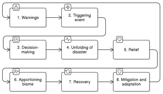
Figure 1.
The disaster cycle.
Over the twentieth century, global mortality from natural hazards declined notwithstanding episodic catastrophes (Figure 2), reflecting improvements in early warning and response. Such trend data offer context rather than causal inference and are treated as background motivation for the need to keep advancing capability [19]. Against this backdrop, operational gaps persist in fast-moving urban crises: fragmented data flows across agencies, delays between sensing, modelling, and field delivery, and high cognitive load for responders interpreting remote dashboards while making time-critical decisions in complex, damaged environments [20]. The literature examined below addresses these gaps from two complementary directions, DTs and AR, and then considers their integration.
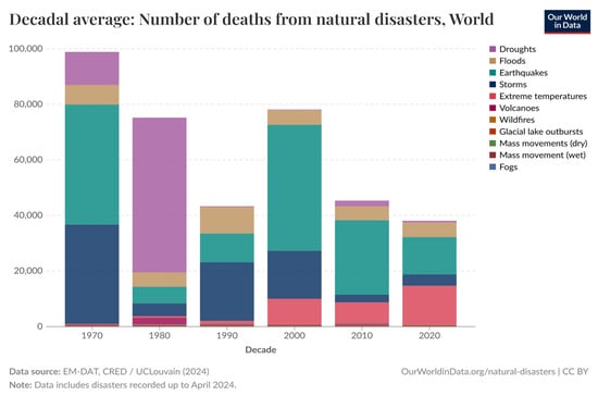
Figure 2.
Global deaths from natural disasters—The shaded ribbon indicates the Wilson 95% confidence interval for decade-level averages [19].
2.2. The Role of Digital Twin in Disaster Management
Digital Twins create synchronised virtual representations of physical assets, networks, and environments that update with live data to support monitoring, analysis, and decision-making (Figure 3). Recent studies demonstrate their use for hazard assessment and emergency decision support, for example, a tornado case where the twin orchestrates data ingestion, state estimation, and scenario analysis to inform actions under uncertainty [3,21]. Reviews emphasise strengths in predictive modelling, real-time monitoring, and enhanced situational awareness across the disaster cycle, while noting the importance of data governance and model validation [6,7,13]. Conceptually, three interlocking elements are evident. Sensing binds the virtual model to the physical world. The model encodes geometry, semantics, and behaviour. Services expose monitoring, diagnosis, optimisation, and training functions. This tripartite view supports lifecycle management and hybrid modelling that couples physics-based components with data-driven elements learned from similar assets, enabling diagnostic fidelity and adaptive forecasting in rapidly evolving incidents [22]. In practice, the promise is greatest where heterogeneous streams, for example, fixed sensors, mobile devices, aerial imagery, and human reports, are fused into a consistent state estimate that informs resource allocation, routing, and triage [23,24]. Several reviews also caution that many reported applications remain at proof of concept with limited field validation, and that integration with legacy systems remains a barrier [7,13,24].
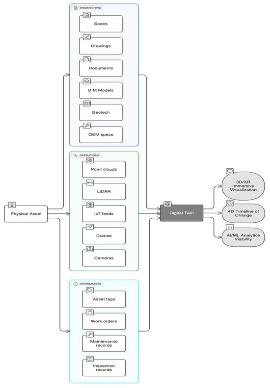
Figure 3.
Comparison between a physical asset and its digital twin.
A comparative reading across studies suggests that DTs tend to excel at back-end analytical tasks that demand coherence at system scale, for example, simulating flood depths on transport networks, testing search-and-rescue coverage given obstructions, or estimating shelter demand under different evacuation schedules [6,13]. By contrast, their value is attenuated when insight must be translated rapidly into on-scene action without adding to cognitive burden. This analysis-to-action gap motivates coupling DT analytics with delivery mechanisms that are immediately intelligible in the field, which is where AR becomes salient.
2.3. Augmented Reality for Emergency Operations in the Built Environment
Augmented reality projects digital cues into the user’s field of view to anchor information to the physical context. In disaster management, studies report the potential of AR to improve understanding of incident conditions, provide real-time overlays of hazards and resources, and strengthen communication among responders through a common operating picture [25,26,27,28]. Within built environments, AR can accelerate structural triage by overlaying schematics and digital blueprints in situ and by georeferencing critical data for safe ingress, egress, and search grids that account for heat, smoke, and stability constraints [28,29,30]. AR has also been used to support realistic user preparation through virtualised disaster scenarios that familiarise personnel with movement and decision-making under stress, addressing human factors barriers to technology uptake [31,32,33]. A state-of-the-art review in the built environment synthesises these trajectories and highlights the need for interface designs that reduce cognitive load, support hands-free operation, and integrate with authoritative data services rather than ad hoc overlays (Figure 4) [4].
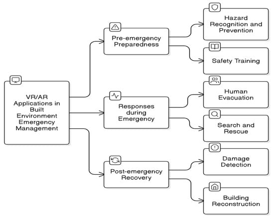
Figure 4.
A framework of using VR/AR technologies for emergency management [4].
Comparatively, AR advances the front-end of emergency management: perception, wayfinding, and team coordination at street or building scale. Its weaknesses are well documented. Device constraints such as field of view, battery life, tracking accuracy, and the risk of information clutter can impair performance in harsh conditions. Moreover, without authoritative, up-to-date data, AR can surface stale or misleading guidance. The implication in the recent literature is that AR’s effectiveness is contingent on robust back-end data and models, standardised data exchange, and carefully engineered human-computer interaction, thereby reinforcing the rationale for pairing AR with DTs rather than treating it as a stand-alone visualisation layer [26,27,28].
2.4. Integrating Digital Twins and Augmented Reality: From Analysis to Action
The strongest argument for integration is functional complementarity. Digital Twins manage multi-scale state estimation and scenario analysis. Augmented reality translates those insights into context-aware cues that support action. Exploratory work on AR and DT combinations in emergency settings reports gains in a common operating picture, decision support, and human interaction, while identifying challenges in data integration, interoperability, and user adoption that require standards and governance, together with structured user preparation [5,11,24]. Studies of AR over DTs for post-earthquake structural assessment show how dynamic twin outputs, for example, damage indicators and stability estimates, can be projected onto the built fabric to guide inspection sequences and entry strategies. Reported benefits include shorter time to triage and reduced duplication [3,29]. Read together, these findings indicate a pipeline in which sensor-driven updates to the twin feed role specific AR views with a clear salience hierarchy, which reduces decision latency and variability in the field.
Integration aligns with the growing emphasis on systems of systems architectures in emergency management. Practitioner studies consistently prioritise IoT, remote sensing, and AI as complementary enablers of incident understanding and prediction. Digital Twins provide the fusion and modelling substrate, while AR acts as the delivery channel for on-scene cognition and coordination [6,26]. Human factors evidence from experimental studies underscores the need for inclusive, low-friction AR experiences that allow hands-free operation, minimise cognitive load, and adapt to user roles. This literature converges on adoption prerequisites that are as much organisational as technical, namely accessible interfaces, multi-device strategies, role-based guidance, and clear governance for data quality, versioning, and accountability [25,31].
2.5. Case Study: Destination Earth
At the planetary scale, the European Commission’s “Destination Earth” initiative illustrates the ambition of exascale DTs for climate and environmental dynamics, including extreme events and their cascading impacts [34]. While DestinE targets policy and planning rather than operational response, several elements are transferable to urban humanitarian logistics: multi-physics modelling that resolves from large-scale drivers to local effects, rigorous data assimilation pipelines, versioned model governance, and visual analytics that convey uncertainty. Less directly transferable are the compute assumptions, the global scope, and the focus on policy timescales rather than seconds-to-minutes operational windows. The implication for city-scale response is the need for nested, lightweight twins that can run incrementally at the edge, backed by cloud services for ensemble simulation and by AR delivery for point-of-action guidance (Figure 5).
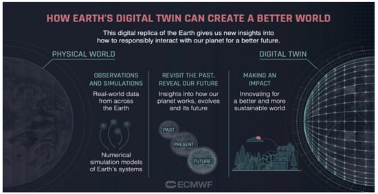
Figure 5.
The vision for the Destination Earth project [19].
2.6. Synthesis and Gaps
Across recent studies, a consistent pattern emerges. DTs offer the analytical backbone for state estimation, prediction, and option testing, especially where data are heterogeneous and interdependencies matter. AR offers the perceptual and collaborative front-end that supports cognition, navigation, and team synchronisation in damaged, data-rich environments. Empirical demonstrations of either technology in isolation are increasingly persuasive, yet fully integrated, field-tested AR-DT systems remain rare [24]. Reported limitations include uneven data quality and interoperability, immature validation practices for twins, device constraints and user acceptance barriers for AR, and the scarcity of rigorous, head-to-head evaluations against incumbent workflows [35,36]. These observations motivate the present study’s contributions: a modular AR-DT framework that specifies how live DT analytics are translated into role-specific AR views, a formative validation with practitioners to prioritise functions and adoption conditions, and an implementation pathway that addresses data standards, governance, multi-device delivery, and role-based training. In doing so, the work operationalises the analysis-to-action bridge identified as a recurrent gap in the literature.
3. Methodology
A rigorous mixed methods design was used to examine the perceived value and practical feasibility of integrating AR and DT technologies for disaster management, and to generate formative evidence to refine the proposed framework. The study adopted a convergent parallel design in which quantitative and qualitative data were collected concurrently through a single instrument, analysed separately, and then integrated at interpretation to corroborate and complement findings [37].
The target population comprised built environment and emergency management professionals working in architecture, civil engineering, urban planning, building information modelling, and construction. A non-probability purposive sampling strategy was applied to recruit participants through professional networks and practitioner lists. The approach was selected to reach domain experts, ensure heterogeneity of roles and organisational contexts, and align with ethical constraints on contacting at-risk populations during emergency operations. Inclusion criteria required current professional practice and familiarity with emergency coordination or infrastructure operations. Students and those without relevant exposure were excluded. Twenty-eight complete responses were obtained. Given the sampling frame, conventional response rate statistics are not meaningful. The study is positioned as exploratory and formative rather than confirmatory.
Data were gathered using a 24-item, self-administered questionnaire that combined closed-ended and open-ended items. The instrument was developed deductively from the literature on AR, DTs, and emergency operations, and iteratively refined to ensure clarity and face validity. Closed-ended items used five-point Likert-type scales to balance response discrimination and respondent burden. Anchors were tailored to each construct, for example, familiarity or perceived usefulness, from 1, very low, to 5, very high. Items were designed to probe distinct capabilities and adoption factors rather than to form multi-item psychometric scales. Analyses were undertaken at the item level. No aggregate construct scores were calculated. The questionnaire covered familiarity and current use, perceived benefits of DTs and AR by disaster management function, attitudes towards AR-DT integration, adoption constraints, user preparation needs, design priorities, and enabling technologies. Open-ended prompts elicited contextual examples, perceived risks, and suggestions for improvement. Participation was voluntary. Informed consent was obtained prior to completion. No personally identifying information was collected. Data were stored and processed in accordance with institutional guidance and applicable data protection regulations. Ethical approval and oversight were secured through the host institution’s research governance procedures.
Quantitative analysis followed an item-level approach suitable for ordinal Likert data and a modest non-probability sample. Descriptive statistics summarised the central tendency and dispersion using proportions across response categories. Where single-category endorsement or majority preferences were of substantive interest, exact binomial tests were used to assess whether the observed proportion exceeded a reference value. Two-sided alpha was set at 0.05, and 95 percent Wilson confidence intervals were reported to emphasise precision. For single-choice items with more than two categories, exact multinomial goodness of fit tests or chi-square tests with Monte Carlo p values were applied as appropriate to evaluate response pattern departures from a uniform or theory-informed distribution. Cramér’s V was reported as an effect size. Where cross tabulations were examined across professional subgroups with small expected cell counts, Fisher’s exact test was used. For contrasts in proportions across two categories, Cohen’s h was reported. Given the exploratory purpose and sample size, emphasis was placed on confidence intervals and effect sizes rather than on strict hypothesis testing. No multiplicity adjustments were applied. p-values are interpreted as descriptive signals.
Qualitative analysis used reflexive thematic analysis, following the six-phase process of familiarisation, initial coding, theme development, review, definition, and reporting. Codes were generated inductively from the data with reference to key concepts drawn from the literature on technology adoption, human technology interaction in emergencies, and system integration. To enhance rigour, a second analyst independently reviewed a stratified subsample of responses. Agreement was assessed using Cohen’s kappa, and discrepancies were resolved by discussion to consensus. An audit trail documented coding decisions, theme revisions, and exemplar quotations. The resulting themes were mapped to components of the framework, for example, data integration, interface design, rehearsal pathways, and governance, and were used to prioritise design requirements, refine terminology, and articulate adoption conditions from a practitioner-centred perspective [38].
Integration of quantitative and qualitative components occurred at two levels. First, joint displays juxtaposed item-level proportions and confidence intervals with representative quotations to illuminate why particular capabilities, such as AR-based overlays, were prioritised. Second, triangulation linked survey signals to specific architectural choices in the framework. For example, consistent reports of accessibility and learnability constraints motivated inclusive, multi-device AR delivery and role-based preparation. Practitioner feedback was mapped to the framework layers, including assets, live data pipelines, hybrid models and simulations, visualisation modules, and workflow linkages, to assess representativeness, feasibility, and completeness. The outcome was a set of targeted refinements and an implementation pathway that addresses interoperability, data quality assurance, user accessibility, user preparation design, and organisational change management. The methodology provides a transparent, practice-informed, and statistically grounded basis for formative validation, while acknowledging limits imposed by sample size, sampling strategy, and the absence of field trials [37].
4. Results
This section presents the development of the integrated augmented AR-DT framework and its formative validation through a mixed-methods study, reporting empirical findings from practitioner surveys alongside qualitative insights that informed refinements to architecture, interfaces, and implementation pathways.
4.1. Framework Development: AR-DT System for Disaster Management
The proposed framework (Figure 6) defines an integrated architecture that couples DT analytics with AR delivery across the disaster cycle, with emphasis on the response phase, where time-critical coordination dominates. The design follows a layered logic that separates sensing and data ingestion, modelling and state estimation, analytics and decision services, and presentation to operators and field users. Live feeds from fixed sensors, vehicles, drones, satellites, and authenticated human reports are fused into a synchronised city-scale DT of assets, buildings, lifelines, terrain, and population distributions. The twin provides an authoritative predictive state to support triage, logistics allocation, search area definition, and evacuation routing. Role-specific AR clients translate model output into in-scene cues, including hazard footprints, stability indicators, safe approach paths, priority tasks, and dynamic routes. In contrast to conventional toolchains that rely on static plans, mobile web maps, and control room dashboards, the framework shortens the analysis-to-action loop by pushing trustworthy updates from the twin to hands-free AR views in the field. Building on these design principles, the next subsections report validation findings and then detail the technical modules that implement them.
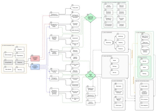
Figure 6.
Integrated Augmented Reality and Digital Twin Framework for Urban Disaster Management.
Table 1 positions the framework against prevailing practice along operational dimensions, namely update latency, spatial grounding at the point of action, cognitive load, collaboration, and resilience under degraded connectivity. Paper plans offer unsurpassed offline robustness but no live operational picture. Mobile maps and GIS dashboards provide a useful overview, but are not designed for in-scene guidance under high stress. Stand-alone AR improves on-scene comprehension yet often depends on static or manually curated data. Stand-alone DTs deliver strong analytics but typically remain in the control room. The integrated platform combines low update latency from sensor to user with role-specific, in-scene overlays driven by the live twin, and is designed to degrade gracefully using on-device caches when networks are unreliable.

Table 1.
Comparative capability of common disaster technologies and the proposed AR-DT platform.
For clarity and reproducibility, the framework is organised from left to right. The left panel locates the two systems that drive operations during response, namely the Disaster Management System and the Adaptive Evacuation Navigation System, within the broader phases of mitigation, preparedness, response, and recovery. The centre panel lists eight operational functions supported by the architecture, namely operational picture and information gathering, emergency communication, rapid decision-making, mobilisation of targeted resources, immediate response activities including detection, alert, and assessment, search and rescue, evacuation and shelter management, and public information and warnings. Dashed connectors indicate which functions are enabled by the DT and AR integration blocks detailed on the right. The right panel decomposes the twin into behaviour, attributes, and management. Behaviour covers monitoring, diagnosing, adapting, and predictive simulation. Attributes cover sensing, model, and service. Management covers lifecycle control, hybrid modelling by similarity, feature extraction, and archiving. Presentation options are listed for web, mobile, graphical interfaces, and AR. A separate panel summarises AR applications in the built environment, consistent with the literature, including hazard visualisation, structural assessment, navigation and wayfinding, resource allocation, and evacuation support.
Each module is linked to explicit evaluation metrics to support pilotability and independent assessment. The sensing and data layer is evaluated by time to a common operating picture from incident detection to a stable fused view, completeness of essential layers at decision time, and twin fidelity measured as error between predicted and observed states for critical variables such as water depth, passable roads, or occupancy. The model layer is assessed by update latency after material changes, short-horizon prediction accuracy, and the success rate of automated error detection and correction. Decision services are evaluated by decision latency for actions such as resource dispatch or evacuation orders, logistics allocation efficiency against service level targets, predicted versus actual search coverage, and the reduction in route re-planning events after hazard updates. Presentation clients are assessed through navigation accuracy, mean evacuation time for representative corridors or buildings, time to achieve a common operating picture across teams, and post-exercise workload ratings to detect cognitive overload. The Adaptive Evacuation Navigation System is instrumented for routing accuracy against ground truth closures, clearance time for staged evacuations, end-to-end alert delivery success and reach, and compliance rates where lawful and proportionate. Communications and governance are evaluated through message latency and delivery success across redundant channels, adherence to role-based access, and audit completeness for decisions and model versions. These metrics align with shortcomings identified in prior work, including delays in establishing a reliable operating picture, brittle handoffs between analysis and field execution, and limited visibility of decision provenance during complex urban incidents.
The architecture supports stepwise adoption and compatibility with established standards and systems. Interoperability is achieved through open BIM and GIS schemas such as IFC 4.3 and CityGML, OGC SensorThings for time series data, and ISO 22320 [39] for incident coordination messages. A practical pathway begins with a bounded pilot district and a small set of incident types, followed by assembly of authoritative data sources and live feeds. A minimal viable twin is then deployed that can ingest streams, update state, and run essential simulations, for example, flood depth and road operability. Operator dashboards and responder applications, including an AR view with offline maps and safety-led interaction limits, are rolled out for structured exercises that progress from table top to live drills. The exercises are instrumented to capture the metrics above, enabling iterative refinement of models, protocols, and interfaces before scaling coverage and capability. Rather than displacing incumbent incident management systems, radio networks, and GIS dashboards, the framework strengthens the seams between them. It maintains a synchronised, auditable record of what was known, when, and by whom, and it reduces the time and effort needed to translate model-based insight into safe movement and coordinated work on the ground.
4.2. Framework Validation
A 24-item practitioner questionnaire was used to provide formative validation of the AR-DT framework. Respondents spanned architecture, civil engineering, urban planning, BIM, and construction roles. The instrument combined single-choice and 5-point Likert items with short free-text prompts and was analysed using exact binomial tests for majority judgements, χ2 goodness-of-fit (with caution, given sample size) for single-choice distributions, and effect sizes (Cohen’s h for single-proportion contrasts with 0.50; Cramér’s V for multi-category concentration). Wilson’s 95% CIs are reported for key proportions; where figures are displayed, error bars denote the same CI family. The purpose of this analysis is formative rather than confirmatory; inferences are bounded by the small, self-selected sample and should be interpreted as practitioner signals that guide pilot design rather than population estimates. The achieved sample (n = 28) comprised civil/structural engineers 32.1% (9), architects 21.4% (6), urban planners 17.9% (5), BIM specialists 14.3% (4), and construction professionals 14.3% (4). This mix is consistent with the intended targeting of built-environment practitioners who would be end-users of AR-DT tools in urban emergencies (Table 2).
Table 2.
Sample composition by discipline.
A large majority judged current disaster-management arrangements as only partially successful rather than highly effective (82.1%; Wilson 95% CI ≈ 73.4–87.8; exact binomial p < 0.001 vs. 0.50; Cohen’s h = 0.697, large). A further 10.7% rated them insufficient. This validates the problem motivation and the scope for augmentation by an AR-DT stack (Table 3).
Table 3.
Key validation items: proportions, Wilson 95% CIs, and effect sizes.
Respondents prioritised situational awareness as the principal contribution of DTs (71.4%; CI ≈ 62.5–79.2; exact binomial p < 0.001; h = 0.442, medium-large), followed by decision-making (39.3%) and inter-team communication (28.6%). The concentration on awareness and decisions aligns with the framework’s live sensing-modelling-analytics pipeline and supports its emphasis on fusing real-time observation with predictive state estimation (Figure 7).

Figure 7.
Perceived impact of digital twins across disaster functions (n = 28). Bars show proportions selecting each function as the greatest impact area; error bars denote Wilson 95% confidence intervals. Exact binomial test against 0.50 for the leading category (situational awareness): p < 0.001; Cohen’s h = 0.442.
Two AR capabilities dominated: real-time, in-scene information overlays (64.3%; CI ≈ 54.9–72.6; exact binomial p = 0.002; h = 0.290, small-medium) and evacuation guidance (57.1%; CI ≈ 47.5–65.8; h = 0.142, small). On a single-choice item concerning decision support, 57.1% selected “provide real-time information and situational awareness”; a χ2 goodness-of-fit test against equal preference across options indicated strong concentration on that choice (reported χ2 with df = 3df = 3, p < 0.001). Collectively, these findings substantiate the design choice to expose role-specific AR views that minimise cognitive load while surfacing authoritative, time-critical cues for both responders and the public (Figure 8).

Figure 8.
Most promising AR applications for disaster management (n = 28). Proportions for real-time information overlays and evacuation guidance dominate; error bars denote Wilson 95% CIs. Exact binomial for overlays: p = 0.002; h = 0.290.
All respondents endorsed the value of integrating DTs with AR, either clear synergies or synergies achievable subject to implementation challenges. The majority view was “significant improvements are feasible, albeit with challenges” (67.9%; h = 0.366). This supports an integration strategy that couples live digital-twin state estimation and short-horizon simulation to hands-free, user-centred AR interfaces. When asked to prioritise considerations for an AR framework, user accessibility and inclusion dominated (60.7%; CI ≈ 51.2–69.4; h = 0.216), followed by multi-device compatibility (32.1%) and then data privacy/security (21.4%). This pattern is consistent with human-factors evidence reported in the literature review and reinforces requirements for accessible interface patterns, offline-tolerant operation, and inclusive device strategies (Figure 9).

Figure 9.
Priority design considerations for an AR disaster-management framework (n = 28). User accessibility/inclusion leads; error bars denote Wilson 95% CIs. Findings triangulate with qualitative comments on inclusivity and training needs.
The technology choices viewed as most complementary to the AR-DT core were IoT sensor networks (39.3%), remote sensing (35.7%), and AI (25.0%). The absence of a single dominant selection supports a system-of-systems approach to data fusion rather than dependence on any single feed or algorithmic technique, again mirroring contemporary practice discussed in the literature review. For preparedness, “high potential for accurate simulations” led (53.6%; exact binomial two-sided vs. 0.50, ns; h = 0.072, very small), with “moderately helpful for decision-making” next (35.7%). Although the effect size is modest, the directional preference is coherent with the framework’s use of short-horizon predictive runs (e.g., flood depth, network status) to support triage, staging, and pre-positioning in control-room contexts (Figure 10).
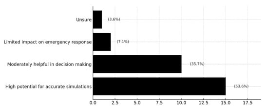
Figure 10.
Perceived role of digital twins in preparedness (n = 28). “High potential for accurate simulations” is the leading single choice; error bars denote Wilson 95% CIs. The result informs the framework’s emphasis on short-horizon predictive runs for staging and pre-positioning.
The principal barrier to AR adoption in response operations was user acceptance and training (71.4%; h = 0.442), ahead of technical compatibility (17.9%) and “no significant obstacles” (10.7%). In dense urban contexts, public awareness/acceptance (39.3%) and navigational accuracy in crowded environments (35.7%) dominated device limitations (14.3%). Training appetite was high, with views split between “some” (53.6%) and “extensive” (46.4%) training. These results justify the implementation pathway’s emphasis on role-based training, safety-led interaction limits, and progressive piloting.
Relative to established GIS dashboards and mobile map viewers, the practitioner signals here privilege faster attainment of a common operating picture via live model-based updates, spatially grounded in-scene AR cues, and reduced cognitive switching between map, model, and field reality. Whereas conventional dashboards can lag on update latency and often rely on user mental transformation from 2D displays to 3D scenes, the AR-DT configuration explicitly targets decision latency, navigation accuracy, and evacuation clearance time, measures that were pre-specified as evaluation metrics for pilot trials in the framework development subsection and are consistent with state-of-the-art evidence summarised in the literature review.
5. Discussion
This study designed and formatively validated an integrated framework in which DTs provide live analytical context and short-horizon prediction, and AR translates those insights into in-scene, cognitively efficient cues for responders and the public. The contribution is the purposeful coupling of these technologies into a single, role-aware workflow, so that live state estimation, simulation, and resource logic from the twin are surfaced as authoritative AR cues at the point of need, rather than remaining on screen-centred dashboards that demand translation effort. The practitioner survey offers consistent signals that this analysis-to-action bridge targets salient pain points in current practice, particularly the time required to form a common operating picture and the cognitive burden of translating two-dimensional dashboards into three-dimensional, rapidly evolving field conditions. The pattern of perceived benefits aligns with prior evidence that DTs strengthen real-time monitoring, predictive modelling, and damage assessment, and that AR improves the operational picture, navigation, and team coordination by surfacing context-relevant information directly in the field of view [26,29].
Adoption conditions surfaced by respondents emphasise human and organisational factors above purely technical integration. User accessibility and preparation were prioritised over interoperability concerns, which is consistent with studies showing that AR’s value in safety-critical settings depends on interaction load, hands-free usability, and trust in the overlay, alongside stable registration and low latency [29]. In response, the framework treats inclusive interaction patterns, multi-device delivery, and role-specific preparation as first-order design requirements. Organisationally, the implication is to favour staged change. Tabletop exercises and controlled drills should precede operational deployment, with governance, auditability, and model versioning embedded from the outset. These emphases are consistent with wider evidence that process change, and interagency coordination frequently bind performance, even when technology functions as designed [40].
The technology mix highlighted by respondents, IoT sensing, remote sensing, and AI, supports a system of systems view rather than reliance on any single component. This aligns with digital twin pipelines that fuse heterogeneous streams for robust state estimation and short-horizon prediction [6,41,42]. The framework’s insistence on open standards across BIM and GIS, streaming ingestion with quality controls, and hybrid modelling, physics-based and data-driven, is a pragmatic response to operational realities such as feed degradation, device failure, or reference frame drift. Large-scale initiatives like Destination Earth, while broader in scope, reinforce the feasibility and limits of synchronising multi-model, multi-source data at scale and offer transferable lessons on stewardship, ensemble simulation, and uncertainty handling for urban incident management.
Benchmarking against existing systems clarifies the incremental contribution. Conventional GIS dashboards and mobile maps remain indispensable for command centres, yet they can impose translation costs on field teams, who must reconcile screen-based, two-dimensional representations with complex, three-dimensional scenes while coping with fragmented refresh cycles. By grounding cues in the environment and driving updates from a single synchronised state model, the AR digital twin configuration seeks to reduce these costs. The study proposes operational metrics to evaluate performance in future pilots, namely time to common operating picture from incident detection, decision latency for key actions, routing accuracy, mean evacuation time, search coverage, time to locate, and logistics allocation efficiency. These metrics enable like-for-like comparisons with tablet-based wayfinding, non-immersive decision support, and control room dashboards reported in prior work.
Limitations are grouped into four themes. Devices and connectivity include battery life, occlusion in crowded scenes, localisation drift indoors, and limited bandwidth during incidents. User preparation and organisational adoption include operator workload, learning curve, and the need for role-based guidance and safety-led interaction limits. Data governance and interoperability include provenance, versioning, audit, and adherence to open schemas and incident messaging standards. Methodological scope includes the small, non-probability sample and the absence of field trials in this formative phase. The analysis emphasised precision via confidence intervals and effect sizes and used exact tests for majority judgements where appropriate, but causal performance gains must be established through field trials or controlled experiments. These themes inform next steps, including controlled simulations and live exercises to measure the proposed metrics against baselines, interface testing under workload to assess usability, trust, and cognitive load, and staged organisational pilots that examine preparation dose response, cross-agency interoperability, and privacy by design. Framed this way, the study offers a grounded blueprint for translating model-based insight into timely, field-ready action and defines measurable claims to be tested in the next phase of research and practice.
6. Conclusions
This study developed and formatively evaluated a conceptual framework that integrates digital-twin analytics with context-aware AR to support urban disaster management. The framework connects live sensing, hybrid modelling, and short-horizon simulation to role-specific AR overlays for responders and the public, with the aim of accelerating the formation of a common operating picture, reducing decision latency, and improving navigation, search, and logistics. Practitioner validation indicates strong perceived value in digital-twin-enabled situational awareness and AR-based in-scene information overlays and evacuation guidance, alongside clear adoption conditions that privilege inclusive, low-friction interfaces, device accessibility, role-based training, and staged organisational change. Compared with prior studies of DTs that emphasise predictive modelling, damage assessment, and resource planning [6,13], the present work advances the analysis-to-action bridge by specifying how live state estimation and short-horizon simulation feed directly into authoritative, role-specific AR cues in the field. Relative to AR research that has demonstrated improvements in situational awareness, structural triage, and wayfinding through in-scene overlays [26,29], the contribution here lies in coupling those overlays to a synchronised, city-scale twin rather than to static or loosely linked data sources. Finally, in contrast with integrated dashboard approaches that remain primarily screen-centred in control rooms [4,42], the proposed architecture grounds decision support where it is executed, in complex three-dimensional scenes, while preserving command-level oversight. Large-scale initiatives such as Destination Earth point to the feasibility and limits of multi-model, multi-source synchronisation; the current framework adapts those lessons to logistics and urban emergency contexts by focusing on tractable, incident-centred twins and disciplined data stewardship.
Several constraints should be acknowledged. Validation is perceptual and practitioner-based, using a small, non-probability sample, and cannot establish causal performance gains. Digital-twin fidelity depends on sustained data acquisition and governance, including calibration, uncertainty tracking, and version control. AR devices remain constrained by battery life, field of view, and tracking stability in degraded environments. Training and public communication are resource-intensive. Costs, maintenance, and evolving requirements suggest incremental deployment, with explicit attention to privacy, security, and interoperability. These limits frame the present work as a formative step that identifies a coherent integration pattern and a set of measurable claims, rather than a summative demonstration of impact.
Future research should progress through staged pilots and controlled experiments that benchmark the AR-digital-twin configuration against established systems such as GIS dashboards and tablet-based navigation. Study designs should quantify time to common operating picture, decision latency for key actions, routing accuracy, and mean evacuation time, search coverage and time-to-locate, and logistics allocation efficiency, while reporting precision via confidence intervals and effect sizes. Human-technology interaction requires focused evaluation under workload, including measures of usability, cognitive load, and trust in overlays, and comparisons of hands-free versus handheld interaction. Organisational pilots should examine training dose–response, cross-agency interoperability, and governance, including data protection and auditability. Theoretically, the findings reinforce socio-technical perspectives that place adoption, workflow fit, and change management on a par with technical capability, and they suggest that effective disaster technologies must minimise cognitive translation cost by aligning model outputs with perceptual and task contexts. In practical terms, the paper offers a modular, standards-aligned implementation pathway: select a bounded pilot area and incident set, assemble authoritative BIM and GIS assets with live sensor and network feeds, deploy a minimal viable twin with essential simulations, deliver device-agnostic AR with offline fallbacks, and evaluate iteratively against the proposed metrics. If subsequent trials confirm improvements on those metrics, AR-enabled DTs provide a realistic and actionable route to faster shared understanding, more timely decisions, and safer, more efficient evacuation and search operations. Taken together with prior evidence on DTs for predictive analysis and AR for in-field support, this work contributes an integrated, human-centred design for turning model-based insight into timely, in-scene action in the conditions that matter most.
Author Contributions
Conceptualisation, S.A.; methodology, S.A.; validation, S.A. and R.J.; formal analysis, S.A. and R.J.; resources, S.A. and R.J.; data curation, S.A. and R.J.; writing—original draft preparation, S.A.; writing—review and editing, S.A.; visualisation, S.A.; supervision, S.A.; project administration, S.A. All authors have read and agreed to the published version of the manuscript.
Funding
This research received no external funding.
Institutional Review Board Statement
The study was conducted in accordance with the Declaration of Helsinki, and the protocol was approved by the University of Portsmouth Faculty of Technology Ethics Committee (Project identification code TETHIC-2023-105364) on 29 March 2023.
Informed Consent Statement
Informed consent was obtained from all subjects involved in the study.
Data Availability Statement
The original contributions presented in this study are included in the article. Further inquiries can be directed to the corresponding author. Please contact Sepehr Abrishami at sepehr.abrishami@port.ac.uk for any inquiries regarding the data.
Conflicts of Interest
The authors declare no conflicts of interest.
References
- Zeng, F.; Pang, C.; Tang, H. Sensors on the Internet of Things Systems for Urban Disaster Management: A Systematic Literature Review. Sensors 2023, 23, 7475. [Google Scholar] [CrossRef]
- Cheng, R.; Hou, L.; Xu, S. A Review of Digital Twin Applications in Civil and Infrastructure Emergency Management. Buildings 2023, 13, 1143. [Google Scholar] [CrossRef]
- Kamari, M.; Ham, Y. AI-based risk assessment for construction site disaster preparedness through deep learning-based digital twinning. Autom. Constr. 2022, 134, 104091. [Google Scholar] [CrossRef]
- Zhu, Y.; Li, N. Virtual and augmented reality technologies for emergency management in the built environments: A state-of-the-art review. J. Saf. Sci. Resil. 2021, 2, 1–10. [Google Scholar] [CrossRef]
- Gong, P.; Lu, Y.; Lovreglio, R.; Lv, X.; Chi, Z. Applications and effectiveness of augmented reality in safety training: A systematic literature review and meta-analysis. Saf. Sci. 2024, 178, 106624. [Google Scholar] [CrossRef]
- Yu, D.; He, Z. Digital twin-driven intelligence disaster prevention and mitigation for infrastructure: Advances, challenges, and opportunities. Nat. Hazards 2022, 112, 1–36. [Google Scholar] [CrossRef] [PubMed]
- Ariyachandra, M.R.M.F.; Wedawatta, G. Digital Twin Smart Cities for Disaster Risk Management: A Review of Evolving Concepts. Sustainability 2023, 15, 11910. [Google Scholar] [CrossRef]
- Nguyen, R.; Gouin-Vallerand, C.; Amiri, M. Hand interaction designs in mixed and augmented reality head mounted display: A scoping review and classification. Front. Virtual Real. 2023, 4, 1171230. [Google Scholar] [CrossRef]
- Setijadi Prihatmanto, A.; Prasetyadi, A.; Yoganingrum, A.; Sutriadi, R.; Hadiana, A. The Digital Twin City in Enhancing Flood Evacuation Systems: Future Opportunities and Challenges. IEEE Access 2025, 13, 32371–32383. [Google Scholar] [CrossRef]
- Ding, Y.; Zhang, Y.; Huang, X. Intelligent emergency digital twin system for monitoring building fire evacuation. J. Build. Eng. 2023, 77, 107416. [Google Scholar] [CrossRef]
- Chen, N.; Chen, L.; Ma, Y.; Chen, A. Regional disaster risk assessment of China based on self-organizing map: Clustering, visualization and ranking. Int. J. Disaster Risk Reduct. 2019, 33, 196–206. [Google Scholar] [CrossRef]
- Ford, D.N.; Wolf, C.M. Smart Cities with Digital Twin Systems for Disaster Management. J. Manag. Eng. 2020, 36, 04020027. [Google Scholar] [CrossRef]
- Habib, A.; Habib, M.; Bashir, B.; Bachir, H. Exploring the Sustainability Benefits of Digital Twin Technology in Achieving Resilient Smart Cities During Strong Earthquake Events. Arab. J. Sci. Eng. 2025, 50, 16869–16883. [Google Scholar] [CrossRef]
- Kwok, P.K.; Yan, M.; Qu, T.; Lau, H.Y.K. User acceptance of virtual reality technology for practicing digital twin-based crisis management. Int. J. Comput. Integr. Manuf. 2021, 34, 874–887. [Google Scholar] [CrossRef]
- Kaplan, Z.; Abrishami, S. Integrating HBIM and Big Data analytics for disaster risk management in cultural heritage conservation. Smart Sustain. Built Environ. 2025. [Google Scholar] [CrossRef]
- UNDRR. Review: Disaster Research Days; United Nations Office of Disaster Risk Reduction: Geneva, Switzerland, 2024; Available online: https://www.undrr.org/publication/review-disaster-research-days-2024 (accessed on 9 September 2025).
- Federal Emergency Management Agency. Disaster Declarations. Available online: https://www.fema.gov/api/open/v2/DisasterDeclarationsSummaries (accessed on 10 September 2025).
- Balamir, M. The “disaster cycle” (DC) and actors in disaster management. Int. J. Disaster Resil. Built Environ. 2022, 14, 185–192. [Google Scholar] [CrossRef]
- Our World in Data. Natural Disasters. Available online: https://ourworldindata.org/natural-disasters (accessed on 10 September 2025).
- Razavi, H.; Titidezh, O.; Asgary, A.; Bonakdari, H. Building Resilient Smart Cities: The Role of Digital Twins and Generative AI in Disaster Management Strategy. In Digital Twin Computing for Urban Intelligence; Pourroostaei Ardakani, S., Cheshmehzangi, A., Eds.; Springer Nature: Singapore, 2024; pp. 95–118. [Google Scholar] [CrossRef]
- Yu, D.; Mahamadu, A.M.; Chen, W. Integration of Immersive Technology and Digital Twins for Emergency Management in Buildings: A Systematic Literature Review. In Applications of Immersive Technology in Architecture, Engineering and Construction: A Handbook, 1st ed.; Routledge: Oxfordshire, UK, 2025; pp. 168–180. [Google Scholar] [CrossRef]
- Durden, J.M. Environmental management using a digital twin. Environ. Sci. Policy 2025, 164, 104018. [Google Scholar] [CrossRef]
- Mahammad Yousuf, M.; Jothi Saravanan, T.; Dash, S.R. Review of Digital Twin Applications for Infrastructure Health Assessment and Disaster Management. In Seismic Hazard Analyses, Wave Propagation and Site Characterization; Kumar, A., Sarkar, R., Maheshwari, B.K., Eds.; Springer Nature: Singapore, 2025; pp. 329–339. [Google Scholar]
- Santos, R.; Ochoa, J.M.; Ochoa, S.F.; Chesñevar, C. Smart cities with digital twin systems for disaster management. In Digital Twin and Blockchain for Sensor Networks in Smart Cities; Nguyen, T.A., Ed.; Elsevier: Amsterdam, The Netherlands, 2025; pp. 481–496. [Google Scholar] [CrossRef]
- Hancko, D.; Majlingova, A.; Kačíková, D. Integrating Virtual Reality, Augmented Reality, Mixed Reality, Extended Reality, and Simulation-Based Systems into Fire and Rescue Service Training: Current Practices and Future Directions. Fire 2025, 8, 228. [Google Scholar] [CrossRef]
- Mirza, M.; Lukosch, S.; Lukosch, H. Exploring the effects of time pressure and distracting elements in an Augmented Reality game for emergency preparedness. Int. J. Disaster Risk Reduct. 2024, 114, 104900. [Google Scholar] [CrossRef]
- Nunes, I.L.; Lucas, R.; Simões-Marques, M.; Correia, N. Augmented Reality in Support of Disaster Response. In Advances in Human Factors and Systems Interaction; Nunes, I.L., Ed.; Springer International Publishing: Cham, Switzerland, 2018; pp. 155–167. [Google Scholar]
- Oztank, F.; Balcisoy, S. Towards Extended Reality in Emergency Response: Guidelines and Challenges for First Responder Friendly Augmented Interfaces. Comput. Animat. Virtual Worlds 2025, 36, e70056. [Google Scholar] [CrossRef]
- Pantoja-Rosero, B.G.; Achanta, R.; Beyer, K. Damage-augmented digital twins towards the automated inspection of buildings. Autom. Constr. 2023, 150, 104842. [Google Scholar] [CrossRef]
- Guo, Y.; Liu, L.; Huang, W.; Shen, M.; Yi, X.; Zhang, J.; Lu, S. Extending X-Reality Technologies to Digital Twin in Cultural Heritage Risk Management: A Comparative Evaluation from the Perspective of Situation Awareness. Herit. Sci. 2024, 12, 245. [Google Scholar] [CrossRef]
- Jindal, R.; Tripathi, A.; Kaur, H.; Sharma, S. Integrating AI, Robotics, and Augmented Reality in Disaster Management. In Addressing Environmental Challenges With AI, Robotics, and Augmented Reality; Azrour, M., Hossain, I., Haque, A.K.M.M., Eds.; IGI Global Scientific Publishing: Hershey, PA, USA, 2025; pp. 289–324. [Google Scholar] [CrossRef]
- Upadhyay, B.; Brady, C.; Chalil Madathil, K.; Bertrand, J.; McNeese, N.J.; Gramopadhye, A. Collaborative augmented reality in higher education: A systematic review of effectiveness, outcomes, and challenges. Appl. Ergon. 2024, 121, 104360. [Google Scholar] [CrossRef] [PubMed]
- Safranoglou, I.; Stavroulakis, A.; Ebel, M.; Pottebaum, J.; Lamprinakis, G.; Dimelli, D.; Mania, K. Augmented Reality for Real-time Decision-Making in Flood Emergencies. In Proceedings of 2024 IEEE International Symposium on Mixed and Augmented Reality Adjunct (ISMAR-Adjunct), Bellevue, WA, USA, 21–25 October 2024; pp. 110–116. [Google Scholar] [CrossRef]
- European Centre for Medium-Range Weather Forecasts. Destination Earth. Available online: https://www.ecmwf.int/en/about/what-we-do/environmental-services-and-future-vision/destination-earth (accessed on 10 September 2025).
- Catal, C.; Akbulut, A.; Tunali, B.; Ulug, E.; Ozturk, E. Evaluation of augmented reality technology for the design of an evacuation training game. Virtual Real. 2020, 24, 359–368. [Google Scholar] [CrossRef]
- Ghaffarian, S. Rethinking digital twin: Introducing digital risk twin for disaster risk management. Npj Nat. Hazards 2025, 2, 79. [Google Scholar] [CrossRef]
- Creswell, J.W.; Creswell, J.D. Research Design: Qualitative, Quantitative, and Mixed Methods Approaches, 5th ed.; SAGE Publications, Inc.: London, UK, 2018. [Google Scholar]
- Wolcott, H.F. Writing Up Qualitative Research, 3rd ed.; SAGE Publications, Inc.: London, UK, 2009. [Google Scholar]
- ISO Standard 22320:2018; Security and resilience—Emergency management—Guidelines for incident management. International Organization for Standardization: Geneva, Switzerland, 2018.
- Costa, C.; Gomes, E.; Rodrigues, N.; Gonçalves, A.; Ribeiro, R.; Costa, P.; Pereira, A. Augmented reality mobile digital twin for unmanned aerial vehicle wildfire prevention. Virtual Real. 2025, 29, 71. [Google Scholar] [CrossRef]
- Macatulad, E.; Biljecki, F. Continuing from the Sendai Framework midterm: Opportunities for urban digital twins in disaster risk management. Int. J. Disaster Risk Reduct. 2024, 102, 104310. [Google Scholar] [CrossRef]
- Korkmaz, M.; Zulfikar, A.C.; Demirkesen, S. Leveraging Digital Twins as a Common Operating Picture for Disaster Management: Case of Seismic Hazards. ISPRS Int. J. Geo-Inf. 2024, 13, 430. [Google Scholar] [CrossRef]
Disclaimer/Publisher’s Note: The statements, opinions and data contained in all publications are solely those of the individual author(s) and contributor(s) and not of MDPI and/or the editor(s). MDPI and/or the editor(s) disclaim responsibility for any injury to people or property resulting from any ideas, methods, instructions or products referred to in the content. |
© 2025 by the authors. Licensee MDPI, Basel, Switzerland. This article is an open access article distributed under the terms and conditions of the Creative Commons Attribution (CC BY) license (https://creativecommons.org/licenses/by/4.0/).