Article

Research on UAV 3D Airspace Signal Strength Prediction Based on Physical Perception Feature Engineering


1
Faculty of Applied Sciences, Macao Polytechnic University, Macao 999078, China
2
Macao Polytechnic University, Macao 999078, China
3
Technology R&D Department, WellWin Technology Limited, Macau 999078, China
*
Author to whom correspondence should be addressed.
Mathematics 2026, 14(8), 1399; https://doi.org/10.3390/math14081399
Submission received: 11 February 2026 / Revised: 10 April 2026 / Accepted: 14 April 2026 / Published: 21 April 2026
(This article belongs to the Special Issue Applications of Machine Learning and Pattern Recognition)

Abstract

With the rapid development of the low-altitude economy, constructing an accurate unmanned aerial vehicle (UAV) air-to-ground channel model is crucial for ensuring communication quality. However, due to the significant fluctuations in UAV operation altitudes and the complex propagation environment, traditional empirical models struggle to achieve universal high-precision prediction within a 3D airspace. This paper proposes a Physics-Informed Feature Engineering (PIFE) method and constructs a 3D signal strength prediction model in combination with Gradient Boosting Decision Tree (XGBoost). Unlike traditional purely data-driven methods, this paper explicitly extracts physical propagation features such as three-dimensional Euclidean distance and height-to-angle ratio, and specifically designs a height–path loss interaction term to capture the nonlinear coupling relationship of signal attenuation at different operating heights. The experimental results demonstrate that the model proposed in this paper performs excellently in multi-altitude airspace scenarios ranging from 70 m to 150 m. At the typical operation height of 70 m, the model achieves a high goodness of fit ( R 2 ) of 0.843. Ablation experiments further confirm that the introduction of physical interaction features successfully breaks through the performance bottleneck of pure geometric features, proving the necessity of explicitly modeling the height–distance coupling effect in complex three-dimensional airspace. The research in this paper demonstrates the effectiveness of integrating physical priors with machine learning algorithms, providing an important theoretical basis and technical support for future drone network planning and coverage optimization in complex low-altitude environments.

1. Introduction

1.1. Background and Motivation

With the acceleration of global digital transformation, the Low-Altitude Economy is gradually emerging as a new engine driving future economic growth. As a key component of 5G-Advanced and the future 6G Space-Air-Ground Integrated Network (SAGIN), unmanned aerial vehicles (UAVs) not only exhibit tremendous application potential in vertical industries such as logistics and distribution, emergency rescue, and smart city inspection, but are also defined by 3GPP as a novel Aerial User Equipment (AUE) [1,2]. In these emerging service paradigms, ensuring the reliability of communication links is a fundamental prerequisite for advanced network coordination and task offloading optimization [3]. However, to achieve Beyond Visual Line of Sight (BVLOS) flight and highly reliable command and control of drones in complex urban environments, a core physical issue must first be addressed: how to establish an accurate, robust, and computationally efficient Air-to-Ground (A2G) channel model.
Unlike terrestrial cellular networks designed for ground user equipment, the electromagnetic environment of UAV air-to-ground communication exhibits inherent unique complexity in three-dimensional space. According to the description in 3GPP TR 38.901 standard [4], the communication channel from the drone to the ground (A2G) mainly relies on the direct transmission of signals, but it is also significantly affected by factors such as signal reflection, object obstruction, and frequency shift caused by the movement of the drone. A further critical challenge is that existing terrestrial cellular networks are inherently designed for ground-based users, and the main beam of the base station antenna is usually fixed to a downward tilt. This means that when the drone is flying at heights of tens or even hundreds of meters, it is actually receiving signals through the side lobes of the base station antenna [5], or even the areas with particularly weak signals where the signal is zero. This causes the signal strength received by the drone (RSRP) not to simply decrease as the distance increases. Instead, it will exhibit unstable and highly fluctuating behavior as the flight altitude changes. Therefore, accurately predicting this complex three-dimensional signal coverage situation is particularly important for ensuring uninterrupted drone communication and planning flight paths that can sense the quality of the signal.

1.2. Limitations of State of the Art

A lot of research has been conducted in the field of channel modeling. When existing methods are applied to dynamic communication scenarios such as those involving drones, a fundamental “triangular problem” still cannot be avoided: modeling accuracy, computing speed and generalization ability. These three aspects cannot be balanced; one aspect has to be sacrificed for the sake of another. Currently, the commonly used modeling methods can be roughly classified into three categories, but each category has obvious shortcomings.
  • Empirical Stochastic Models: For the Hata, COST-231 and 3GPP logarithmic distance models, their characteristics are simple analysis form and low computational requirements. However, they are mainly based on ground measurement accessories and describe the environment through simplified path loss indices. In complex urban canyons, these models lack spatial granularity and cannot consider specific building layouts or vertical signal fluctuations caused by antenna side lobes. As stated in the reference [6], the prediction errors of empirical models in heterogeneous environments usually exceed 10 dBm, which is insufficient for high-precision unmanned aerial vehicle tasks.
  • Deterministic Models: These include ray tracing (RT) [7] and digital twin-based simulations [8]. These methods use high-precision 3D electronic maps and reconstruct propagation paths (reflection, diffraction, and scattering) by solving approximations of Maxwell’s equations. Although they offer high physical fidelity, their application is limited by two factors: first, the cost of acquiring real-time high-precision 3D geometry data is too high; second, the computational complexity is extremely high. A single ray-tracing simulation can take several hours, making it unsuitable for resource-constrained in-vehicle chips and unable to support real-time tasks such as online path re-planning.
  • Data-Driven Machine Learning Models: In recent years, deep learning (DL) has been widely applied in channel modeling. For instance, satellite images combined with convolutional neural networks (CNNSs) have been employed for feature extraction [9], while Transformers have been utilized for time series signal processing [10]. Although these models perform well within the training distribution, they have problems such as “black box” opacity and lack of inductive bias:
    Dimensionality and Generalization Failure: Most deep learning models tend to remember “location-signal” mappings rather than learn underlying physical laws. When the height of the drone changes (for example, training at 70 m but testing at 150 m), the model will encounter covariate offsets. In the absence of physical constraints, pure data-driven models usually fail to accurately predict antenna gain changes, resulting in a sharp decline in generalization ability.
    Computational Paradox: Complex architectures like Transformers contain millions of parameters, leading to high inference latency. For a UAV cruising at 20 m/s, even millisecond-level delays can lead to signal loss, which is unacceptable in practical engineering.
    Lack of Interpretability: As emphasized in [11], uninterpretable AI models pose safety risks in aviation communications, as engineers cannot diagnose the physical causes of prediction failures.

1.3. Our Contribution: Physics-Informed Feature Engineering

To bridge the aforementioned gap, this paper proposes a novel framework that integrates the advantages of physical mechanisms and data-driven approaches—Physics-Informed Feature Engineering (PIFE) integrated with XGBoost model.
The core principle of this work is to embed physical propagation laws into the model design explicitly, rather than allowing the machine learning model to implicitly infer physical mechanisms from raw data alone. We have abandoned blind end-to-end black-box learning and instead converted the nonlinear modulation effect of antenna radiation patterns in the vertical domain into inputs that the model can understand by explicitly constructing geometrical features with physical significance (especially height–distance interaction terms). This approach essentially introduces strong prior knowledge of electromagnetic wave propagation into the feature space.
The main contributions of this paper are summarized as follows:
  • We propose a novel PIFE-XGBoost framework: This work proposes a novel modeling framework that fuses physics-based geometric features with the lightweight and computationally efficient gradient boosting tree algorithm. This framework not only achieved the competitive prediction accuracy compared to existing baseline models in scenarios ranging from 70 to 150 m in height, but also successfully disentangled the complex interplay between height and distance, solving the common problem of pure data-driven models where they are prone to misinterpreting local noise (overfitting) in the vertical height direction.
  • We have clarified the nonlinear correlation pattern between altitude and signal attenuation: We used the “information gain” indicator to clearly demonstrate how the altitude of the unmanned aerial vehicle dynamically affects the degree of signal attenuation. The height and angle interaction features we constructed are particularly crucial for capturing the influence of the base station antenna’s side lobe, and also provide a new theoretical reference for analyzing the channel characteristics between the unmanned aerial vehicle and the ground.
  • Balances Prediction Accuracy and Computational Efficiency: >By leveraging the optimized gradient boosting structure, our proposed PIFE-XGBoost achieves an exceptionally low inference latency of approximately 6.87 μ s per sample. Compared to computationally intensive deep learning architectures (e.g., Transformer-based models), our method significantly reduces the computational overhead, making it highly suitable for deployment on resource-constrained platforms such as the Raspberry Pi. This level of efficiency is well-suited for the real-time requirements for autonomous UAV path planning and signal monitoring.
  • Enhancing Model Interpretability and Transparency: Using SHAP (SHapley Additive exPlanations) analysis, we convert the black-box model into an interpretable white-box framework. By visualizing the marginal contributions of physical features, we not only improve model reliability but also provide empirical support for the strong correlation assumptions adopted in the 3GPP standard channel model.

1.4. Paper Organization

The remaining part of this article is arranged as follows: Section 2 reviews the related work. Section 3 describes the proposed experimental methods and the construction of PIFE features. Section 4 details the data collection process and the specific experimental procedures. Section 5 presents the experimental results, conducts multi-dimensional comparative analysis, and looks forward to the conclusions of the paper and future research directions.

2. Related Work

Channel modeling for unmanned aerial vehicle (UAV) air-to-ground (A2G) communication is the core cornerstone for achieving future 6G air-to-ground integrated network coverage and quality assurance. With the explosion of artificial intelligence technology, the research paradigm in academia is shifting from traditional deterministic modeling to data-driven modeling. Traditional deterministic methods, such as the ray tracing technique proposed by Auer et al. [7] or the simulation based on digital twins proposed by Tang et al. [8], can provide accurate physical field reconstruction. However, their dependence on high-precision 3D maps and significant computational overhead limit their application in real-time tasks. Therefore, finding the optimal balance between model prediction accuracy, generalization ability, and computational efficiency remains a pressing challenge to be addressed.
This chapter will systematically review existing mainstream modeling methods, with a focus on analyzing deep learning methods based on computer vision and time series prediction methods based on sequence models, and delve into their limitations in the dynamic environment of UAVs.

2.1. Channel Modeling Assisted by Computer Vision and Its Dimensional Limitations

At present, satellite remote sensing technology is gradually becoming widespread, and using environmental images to assist in river modeling has become a research hotspot in recent years. The core assumption is that the propagation characteristics of wireless signals are highly correlated with the visual textures of the geographical environment.
In the representative works of this field, Sani et al. [9] proposed a hybrid modeling framework based on convolutional neural networks (CNN), which directly utilizes 2D satellite images to extract urban texture features for predicting path losses. Similarly, Nagao et al. [12] attempted to use machine learning to extract urban structural parameters. Compared with traditional empirical models, these methods demonstrate the potential of unstructured visual data in channel modeling.
After conducting a thorough analysis of the physical mechanism of drone communication, we discovered that this method based on 2D images has inherent limitations in terms of insufficient dimensions:
1.
Satellite images are usually taken from the Nadir view, and this view inevitably loses the height information of the vertical dimension through this two-dimensional projection. For ground communication, the height of the base station is fixed, and this simplification is acceptable; however, for drone communication, the flight height is a key variable determining the link quality. As the classic theory by Al-Hourani et al. [13] states, the change in the drone’s height directly alters the probability of line-of-sight (LoS). The CNN model proposed by Sani et al. [9] can only perceive the “planar texture” of the ground, but cannot perceive the relative position of the drone in the “vertical space”, resulting in the model being unable to understand the effect of the elevation angle on the Fresnel gap.
2.
Physical bottleneck of generalization ability: Due to the lack of explicit 3D geometric feature input, CNN models primarily memorize statistical correlations between image textures and signal intensities. When the model is transferred to new areas with different building height distributions, its prediction performance often experiences a significant decline.
In contrast, the PIFE framework proposed in this paper abandons redundant visual inputs and instead explicitly constructs a “height–distance interaction term” to directly reconstruct the three-dimensional geometric relationship between the UAV and the base station at the mathematical level.

2.2. Time Series Prediction Based on Heavy Deep Learning and Its Computational Power Paradox

Given the rapidly time-varying nature of channel states during UAV movement, another research direction tends to employ deep learning models that handle sequential data.
In response to the high reliability requirements of 6G mmWave communication, Zhang et al. [10] innovatively introduced the Transformer architecture into A2G channel modeling. Meanwhile, Kaur et al. [14] also explored a time series prediction model based on LSTM. These studies utilize attention mechanisms or gated units to capture long-range signal dependencies, demonstrating high accuracy in handling complex nonlinear fading sequences.
As long as the collected data is of good quality, these complex models can perform well. However, when they are actually used, due to their inherent complexity, the response speed is relatively slow. This becomes a significant drawback in scenarios where drones are flying at high speeds.
1.
Both the Transformer and LSTM models contain millions of parameters. Although they can function properly on powerful GPU servers, they are not suitable for the edge scenarios where drones are used, and it is difficult to support such large-scale matrix calculations.
2.
The delay in response poses the risk of “being unable to make timely decisions”. In the task of “planning the flight path based on the signal conditions”, the model’s response speed must be at the millisecond level or higher (even a slight delay is unacceptable).
  • Engineering Case Analysis: Consider a drone cruising at a speed of 20 m/s. If a deep learning model (such as [10]) takes 100 ms to generate predictions, this means that during the time the model is calculating, the drone has actually flown blindly for 2 m. In urban canyons with severe multipath effects, this 2-m displacement is sufficient to cause the drone to plunge into a signal blind zone.
  • Advantages of this paper: In comparison, the PIFE-XGBoost algorithm chosen in this paper is essentially a set of lightweight decision trees, capable of achieving microsecond-level response (approximately 6.87 μ s on average). This real-time closed-loop of “perception-decision” is an engineering advantage unmatched by heavy deep learning models.

2.3. The Regression of Interpretable Artificial Intelligence (XAI) and Physical Prior Knowledge

For a long time, machine learning has often been criticized as a “black box” technology in the field of wireless communication. Whether it is early neural network models such as Ostlin et al. [15], or the current Transformer [10], the internal weights often lack clear physical significance. As Shakya et al. [11] pointed out in their XAI research, this uninterpretability is fatal in aviation communication, where safety requirements are extremely high.
In light of this, the research presented in this paper follows the “physics-guided” modeling approach. We incorporate prior knowledge about electromagnetic wave propagation into the model through Physics-Informed Feature Engineering (PIFE). For instance, inspired by the research on antenna radiation patterns by Maeng et al. [16], we explicitly construct highly interactive terms.
Our model has the characteristic of being clearly interpretable, rather than being an incomprehensible black box. By analyzing the degree of influence each feature has on the result, we can clearly determine the flight altitude, communication distance and signal angle that are calculated. These three factors respectively have certain kinds of impact on the signal quality. This makes the process of the model making a judgment more intuitive and more convincing. This not only makes the model itself more reliable, but also provides solid theoretical basis and practical reference for designing more stable and efficient drone communication protocols in the future.

2.4. Chapter Summary

Although the deep learning methods proposed by Sani et al. [9] and Zhang et al. [10] have achieved certain progress in specific scenarios, their performance is suboptimal and accompanied by notable limitations when applied to UAV communication scenarios. This is primarily due to the high complexity of the three-dimensional spatial environment for UAV flight and the computational resource constraints of on-board UAV equipment. In our paper, we proposed the PIFE-XGBoost framework to solve this problem.
  • By integrating physical laws to construct features, the prediction blind zone in the vertical direction of the 2D model has been resolved.
  • By adopting lightweight and computationally efficient algorithms, this work overcomes the low real-time decision-making bottleneck of complex deep learning models.
  • The interpretability derived from physical principles has addressed the risk of unreliable performance in black-box models.

3. Methodology

To address the limitations of existing empirical and pure data-driven models identified in the previous section (specifically the lack of spatial granularity, high computational demand, and “black-box” nature), this paper proposes the PIFE-XGBoost framework. The design of this framework is guided by three core principles to ensure its suitability for real-world unmanned aerial vehicle (UAV) communication tasks:
  • Physics-Guided Feature Integration: By explicitly constructing geometric features based on electromagnetic propagation laws, such as height–distance interactions, our model resolves the “prediction blind zones” in the vertical domain that typically plague 2D or unconstrained data-driven models.
  • Computational Efficiency for Real-Time Deployment: By adopting lightweight and gradient-boosted tree architecture, the framework overcomes the high inference latency bottleneck of complex deep learning structures, such as Transformers, enabling microsecond-level decision-making on resource-constrained UAV on-board equipment.
  • Model Transparency and Interpretability: Moving beyond black-box estimation, the integration of physical principles allows for systematic diagnosis of model outputs. By using interpretability tools, we ensure that the predictions remain consistent with established radio propagation theory, thereby enhancing aviation communication safety.

3.1. 3D Geometric Modeling and Relative Position Representation

To eliminate the influence of Earth curvature on distance calculation, we convert the original geodetic coordinate system (WGS-84) into a local Cartesian coordinate system (ENU). This step serves as the foundation for constructing a high-precision UAV trajectory prediction model [17].
Assuming the base station (BS) as the reference origin, its geographical coordinates are P B S = [ λ B S , ϕ B S , h B S ] T , and the instantaneous position of the unmanned aerial vehicle (UAV) at time t is P u = [ λ t , ϕ t , h t ] T . Compared to the ray tracing technique proposed by Auer et al. [7] or the digital twin method relying on high-precision maps proposed by Tang et al. [8], this paper adopts the Equirectangular Projection, which can map nonlinear spherical coordinates to relative Euclidean coordinates ( x , y , z ) on the local tangent plane with extremely low computational cost:
x = R · ( λ t λ B S ) · cos ( ϕ B S ) y = R · ( ϕ t ϕ B S ) z = h t h B S
where R represents the average radius of the Earth (approximately 6371 km). Based on this, the horizontal projection distance d 2 D and the three-dimensional straight-line distance d 3 D are defined as follows:
d 2 D = x 2 + y 2 d 3 D = P u P B S 2 = x 2 + y 2 + z 2
In addition, to characterize the impact of the vertical gain of the base station antenna, the pitch angle θ of the drone relative to the base station is introduced:
θ = arctan z d 2 D
Explanation of Physical Significance: The aforementioned geometric modeling not only provides basic positional inputs, but more importantly, it lays the foundation for the physical perception feature engineering in Section 3.2. By converting absolute geographic coordinates into d 3 D and θ , the model can shift from “mechanical memory” of geographic locations to “logical deduction” of propagation patterns. This aligns with the findings of Al-Hourani et al. [13,18] in optimal height coverage and suburban modeling, indicating that the height dimension contains critical path loss information independent of horizontal distance, thereby significantly enhancing the generalization ability across different flight heights (70 m–150 m).

3.2. Physics-Informed Feature Engineering (PIFE)

Traditional machine learning models often overlook the physical essence of signal propagation, merely learning mapping relationships from data distribution [11]. To incorporate physical prior knowledge of wireless propagation into a nonlinear regression model, this paper designs a Physical-Informed Feature Engineering (PIFE) framework. This framework maps the geometric variables from Section 3.1 to a high-dimensional physical feature space X p h y to explicitly represent the non-uniform attenuation of air-to-ground channels.

3.2.1. Logarithmic Characteristics of Path Loss

According to the theory of large-scale path loss models (such as the classic Hata model [19] or the 3GPP TR 38.901 propagation model [4]), the attenuation slope of signal power is primarily determined by the logarithm of the propagation distance, i.e., P L ( d ) 10 n log 10 ( d ) . To conform to the propagation laws of electromagnetic waves and accelerate model convergence, this paper extracts the logarithmic distance feature f l o g :
f l o g = log 10 ( d 3 D + ϵ )
where ϵ is a small correction term used to ensure numerical stability. This feature provides the model with the most basic background of free-space diffusion loss, ensuring that the model follows the multi-slope physical attenuation trend proposed by Zhang et al. [20].

3.2.2. Height-Distance Interaction Feature

This is the core contribution of this paper. In the 3D airspace, the increase in drone altitude z not only alters the propagation distance but also nonlinearly modulates the signal strength through the following physical mechanism, which is also mentioned in the study by Maeng et al. [16]:
  • Antenna Gain Modulation: As the height and horizontal distance change, the connection between the drone and the base station will switch between the main lobe and side lobe of the antenna, resulting in significant fluctuations in reception gain.
  • Fresnel Zone Clearance: An increase in height is usually accompanied by an improvement in the probability of line-of-sight (LoS) and a reduction in first-order Fresnel zone blockage, thereby altering the multipath fading characteristics [2].
To capture this complex physical coupling effect, an explicit interaction feature term f i n t e r is designed in this paper:
f i n t e r = z d 3 D sin ( θ )
Physical mechanism analysis: To address the practical challenge where specific base station (BS) parameters—such as precise antenna height, mechanical downtilt, and vertical radiation patterns—are often proprietary and inaccessible in urban UAV missions, the proposed PIFE framework employs the interaction term f i n t e r as a geometric proxy. As shown in (5), f i n t e r directly represents the vertical elevation angle ( sin θ ). In accordance with the 3GPP TR 38.901 model, RSRP fluctuations are heavily governed by the UAV’s traversal through different antenna lobes. By utilizing this trigonometric coupling, the XGBoost regressor is empowered to adaptively learn the non-monotonic transitions between the main lobe and side lobes from empirical data. This design ensures that the model maintains physical consistency and robustness even without explicit metadata, effectively compensating for directional antenna gain variations in complex 3D airspace.

3.2.3. Construction of Comprehensive Feature Vector

Finally, to comprehensively cover geometric spatial information and physical propagation laws, the input feature vector x R 7 of the model is constructed as follows:
x = [ x , y , z , d 3 D , f l o g , θ , f i n t e r ] T
Through this explicit physical feature construction, the PIFE framework converts implicit physical laws into explicit features that are easily separable by XGBoost, thereby enhancing the interpretability and generalization ability of the model.

3.3. RSRP Prediction Model Based on Regularized Boosting Tree

After constructing the set of physical perception features, this paper adopts the Extreme Gradient Boosting (XGBoost) algorithm [21] as the core regressor. XGBoost is an ensemble learning method based on the additive model and forward distribution algorithm, which can effectively capture the complex nonlinear residuals in the air-to-ground channel.

3.3.1. Objective Function and Regularization

To enhance the generalization ability of the model while ensuring prediction accuracy and prevent overfitting in scenarios with different heights ranging from 70 m to 150 m, the structured objective function L ( ϕ ) defined in this paper includes a loss function term and a regularization penalty term:
L ( ϕ ) = i = 1 N l ( y ^ i , y i ) + k = 1 K Ω ( f k )
where l ( · ) is the squared loss function (MSE) that measures the difference between the predicted value y ^ i and the actual measured RSRP value y i . The regularization term Ω ( f k ) is used to constrain the complexity of each decision tree:
Ω ( f ) = γ T + 1 2 λ | | w | | 2
Here, T represents the number of leaf nodes, | | w | | 2 denotes the L2 norm of the leaf weight vector, and γ and λ are hyperparameters that control the complexity of the model, respectively. By introducing this penalty term, the model can automatically perform feature selection when processing multi-height spatial data, avoiding overfitting to noise [11].

3.3.2. Residual Learning Based on Taylor Expansion

The XGBoost model we use differs from the traditional Gradient Boosting Decision Tree (GBDT)—while traditional GBDT only utilizes the information of the first-order derivatives, XGBoost performs a second-order Taylor expansion on the loss function and also utilizes the information of the second-order derivatives. This enables faster model training, accelerated convergence, and more accurate prediction results. During each training update of the model, we input the physical feature vectors x (including f l o g and f i n t e r ) extracted in Section 3.2 as the input. Then, by splitting the nodes that can bring the maximum effect improvement, we approximately simulate the law of channel attenuation. The second-order approximation of the objective function in the tth round is expressed as:
L ( t ) i = 1 N l ( y i , y ^ ( t 1 ) ) + g i f t ( x i ) + 1 2 h i f t 2 ( x i ) + Ω ( f t )
where g i and h i represent the first-order gradient and second-order Hessian of the loss function, respectively:
g i = y ^ ( t 1 ) l ( y i , y ^ ( t 1 ) ) , h i = y ^ ( t 1 ) 2 l ( y i , y ^ ( t 1 ) )
With this more refined second-order processing method, we can directly calculate the optimal value that each splitting node can achieve for the best effect, which is the optimal leaf node score, without resorting to complex calculations. This approach that relies on second-order information for optimization enables the model to more accurately adhere to the actual physical laws when dealing with spatial signals that fluctuate greatly.

3.4. Model Performance Evaluation Metrics

To comprehensively evaluate our proposed PIFE-XGBoost model in terms of the accuracy and adaptability (generalization ability) of signal prediction in a three-dimensional space, we selected three indicators as the criteria for judgment root mean square error (RMSE), mean absolute error (MAE), and fit goodness ( R 2 ).
1.
Root Mean Squared Error (RMSE): RMSE is more sensitive to large prediction errors and can effectively reflect the robustness of the model under extreme signal fluctuations.
R M S E = 1 N i = 1 N ( y i y ^ i ) 2
2.
Mean Absolute Error (MAE): MAE reflects the absolute average level of deviation between the predicted value and the actual value, and has a more intuitive physical meaning (unit: dBm).
M A E = 1 N i = 1 N | y i y ^ i |
3.
Goodness of fit ( R 2 Score): R 2 is used to measure the extent to which the model explains the variance in the spatial distribution of RSRP. The closer R 2 is to 1, the more accurately the model can reproduce the true signal attenuation pattern through physical characteristics.
R 2 = 1 i = 1 N ( y i y ^ i ) 2 i = 1 N ( y i y ¯ ) 2
where y i is the actual measured RSRP value, y ^ i is the model prediction, y ¯ is the mean of the actual measured values, and N is the total number of samples in the test set.

4. Experimental Results and Analysis

4.1. Experimental Environment and Data Acquisition

To verify the effectiveness of the proposed PIFE-XGBoost model in complex urban airspace, this paper conducted high-precision air-to-ground link field experiments in Seac Pai Van, Macau, which was selected as a typical urban test site in related research [5].

4.1.1. Description of Experimental Scenario

The Shipaiwan area is a typical high-density urban residential area, filled with numerous high-rise buildings (approximately 80–100 m in height) with a compact terrain and significant elevation differences. As stated in the 3GPP channel model report [2], this complex urban canyon environment produces severe multipath effects and shadow fading, making it an ideal location to verify the robustness of 3D signal prediction models.

4.1.2. Hardware Platform and Measurement Equipment

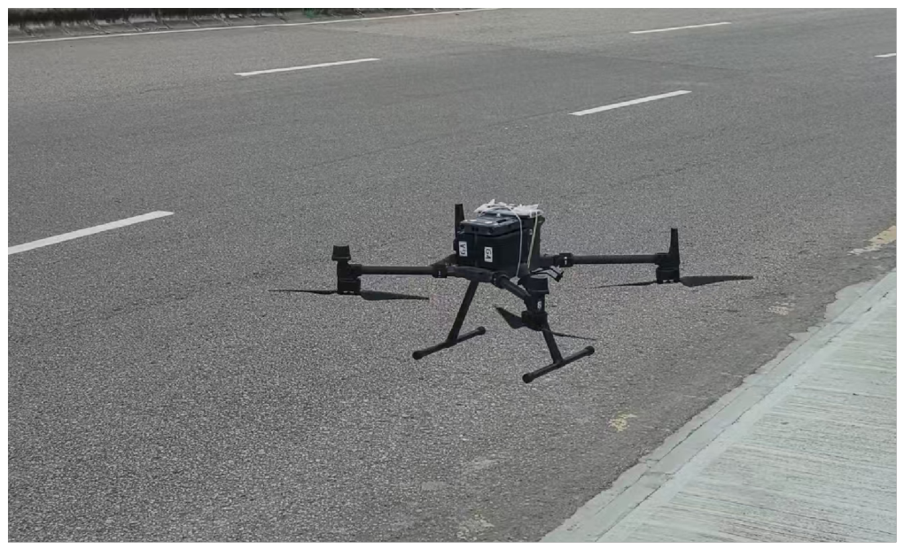
This paper adopts a system that complies with industrial measurement standards [22] to ensure data accuracy, and refers to the air-to-ground channel measurement methodology proposed by Matolak et al. [23]. The actual deployment of the experimental hardware is illustrated in Figure 1.
  • Drone Platform: The DJI Matrice 350 RTK drone, manufactured by SZ DJI Technology Co., Ltd., Shenzhen, Guangdong, China, is selected (as shown in Figure 1). This platform is equipped with advanced RTK (Real-Time Kinematic Carrier Phase Differential) positioning technology, capable of providing centimeter-level three-dimensional position accuracy, ensuring the accuracy of the three-dimensional geometric feature operators in Section 3.1.
  • Data Collection Terminal: The onboard terminal is a Samsung mobile device integrated with the Google framework.
  • Software Configuration: The terminal runs the professional-grade network drive test software G-Net Track Pro V7.0. This software is capable of extracting downlink RSRP (Reference Signal Received Power), cell ID (PCI), and GPS timestamps in real-time at a frequency of 1 Hz, providing a reliable foundation for subsequent data alignment.
To ensure a focus on the core research objective of large-scale path loss modeling in three-dimensional UAV air-to-ground communication spaces, this study conducted field experiments under conditions of UAV stable hovering and linear uniform flight (flight speed: 5–8 m/s). The measured Reference Signal Received Power (RSRP) primarily reflects the large-scale signal attenuation patterns controlled by propagation distance and flight altitude. Since RSRP measurements represent the median path loss and involve time-frequency averaging, small-scale fading effects such as Doppler shifts and multipath fast fading are effectively suppressed, making the large-scale channel modeling the primary focus of this predictive framework. Factors such as small-scale fading effects (including multipath interference and Doppler shifts caused by UAV motion) and signal attenuation due to UAV maneuvers (e.g., turning, diving) or blockage (e.g., wing obstruction of on-board antennas, temporary shielding by buildings) are not included in the current experimental design. This scenario restriction is intended to prioritize the validation of the effectiveness of Physical Information Feature Engineering (PIFE) in capturing the nonlinear coupling relationship between altitude and distance, and to ensure the real-time inference performance of the lightweight XGBoost model, which is the core contribution of this study. To ensure the consistency of the RSRP measurements used for large-scale path-loss representation, the UAV maintains a stable cruising attitude throughout the data collection process. While transient fluctuations may be introduced by specific maneuvers or airframe shadowing, these effects are beyond the scope of this study and will be addressed in future work.

4.1.3. Data Acquisition and Preprocessing

  • Equipment: Use a Samsung mobile phone to set up G-Net Track Pro and attach the phone to the drone. Combine it with the longitude, latitude and altitude coordinates recorded by the M350 RTK to build the original dataset. The dataset recorded signals from the LTE network of China Telecom (Band 1, EARFCN: 1000) with a carrier frequency of 2.1 GHz. To ensure data consistency, UEs are locked to a specific serving cell (PCI: 103) and handoff events are eliminated. The UAV maintained a constant cruising speed of 5 m/s at all test altitudes: 70 m, 100 m, 120 m and 150 m to ensure controlled experimental conditions.
  • Project anomaly cleaning: We handle some missing signals or sudden signal failures that cause inaccurate collected data. According to the statistical insights provided by Auer et al. [7] and Gustafson et al. [24], we use a 3 σ threshold to identify and prune sampling outliers. Additionally, we manually review the signal logs to discard segments affected by unstable signal transitions, ensuring that the final training set accurately reflects stable propagation conditions in the 3D space.
  • Spatial transformation: We performed a spatial transformation on the Shipaiwan dataset to convert raw GPS coordinates into relative Cartesian positions. The original GPS coordinates were converted from the base station as the origin to relative Cartesian coordinates. To strictly prevent the leakage of spatial data (Spatial Data Leakage), the final 8598 samples were divided into training set 80% and test set 20% according to the chronological order (temporal division).
  • Coordinate projection accuracy: To ensure the spatial fidelity of distance features, we evaluated the projection error of the Equirectangular Projection (ERP) used in this study. The maximum horizontal range of the Macao Experimental Zone is approximately 1.5 km. Based on the standard WGS84 to ENU (East North Up) transformation, the maximum relative distance distortion at this scale and latitude (approximately 22° N) is less than 0.15 m. This confirms that the Euclidean distance derived from the projected coordinates is sufficiently accurate for UAV signal modeling, where the link budget tolerance is significantly greater than the geometric approximation error.

4.2. Experimental Setup and Evaluation Metrics

4.2.1. Data Preprocessing and Feature Construction

Before feeding the data into the model, we first conducted a large-scale cleaning process, discarding all the useless data. To stabilize the gradient descent during the ensemble learning process, we normalized the spatial features. Inspired by the empirical Hata model [19], our feature engineering strategy went beyond simple distance fitting and encoded the physical prior as the following features.
  • 3D Logarithmic Attenuation Factor ( d log _ 3 d ): Recognizing that RSRP scales logarithmically with Euclidean separation, we calculate the 3D distance between the UAV and the BS as:
    d log _ 3 d = 10 log 10 ( x u x b ) 2 + ( y u y b ) 2 + ( h u h b ) 2
    Explicitly providing this log-scaled metric simplifies the XGBoost decision splitting process, effectively linearizing the fundamental power-law path loss.
  • Geometric Elevation Proxy ( η h _ dist ): To account for the altitude-dependent variations in Line-of-Sight (LoS) probability [20], we define the ratio of altitude to horizontal distance:
    η h _ dist = Δ h d horizontal = h u h b ( x u x b ) 2 + ( y u y b ) 2
    This ratio serves as a critical indicator for shadowing conditions, helping the model distinguish between unobstructed LoS and complex Non-Line-of-Sight (NLoS) propagation at different flight levels.
  • Relative Spatial Offsets ( Δ x , Δ y ): Instead of absolute GPS coordinates, we utilize Cartesian offsets relative to the BS. This localized coordinate system focuses the learning process on site-specific shadow fading patterns within the Shipaiwan area, preventing the model from becoming biased toward global position values.

4.2.2. Model Implementation and Parameter Settings

To conduct a comprehensive ablation experiment analysis, we implemented three comparative models based on the Python environment (utilizing Scikit-learn 1.7.2, XGBoost 3.1.1, and GPBoost libraries 1.6.4.2):
1.
Random Forest (Baseline): We used this as a baseline model to evaluate basic predictability, without strong physical features or gradient boosting mechanisms. For parameter settings, we refer to the configuration of Sotiroudis et al. [25].
2.
PIFE-XGBoost (Proposed): The core model proposed in this paper. Utilizing the XGBoost framework by Chen et al. [21], this model inputs physical perception features into the regressor. The key hyperparameters optimized through grid search are set as follows: the number of weak estimators ( n _ e s t i m a t o r s ) is set to 600; the maximum tree depth ( m a x _ d e p t h ) is set to 10; and the learning rate ( l e a r n i n g _ r a t e ) is set to 0.03.
3.
XPBoost (Comparison): This is a hybrid model that combines gradient boosting with Gaussian Process (GP), and employs the Vecchia approximation proposed by Tang et al. [8] to accelerate the computation of spatial residuals. The model is set up to verify whether introducing complex spatial statistical models can bring greater performance gains compared to pure physical feature engineering.

4.2.3. Evaluation Metrics

To quantitatively evaluate the performance of various models in predicting three-dimensional spatial signals, this paper selects two standard evaluation metrics: Mean Absolute Error (MAE) and Coefficient of Determination ( R 2 ).
M A E = 1 n i = 1 n | y i y ^ i |
R 2 = 1 i = 1 n ( y i y ^ i ) 2 i = 1 n ( y i y ¯ ) 2
where y i is the true measurement value of RSRP, y ^ i is the predicted value from the model, and y ¯ is the mean of the true values.

4.3. Quantitative Performance Evaluation

4.3.1. Ablation Experiment

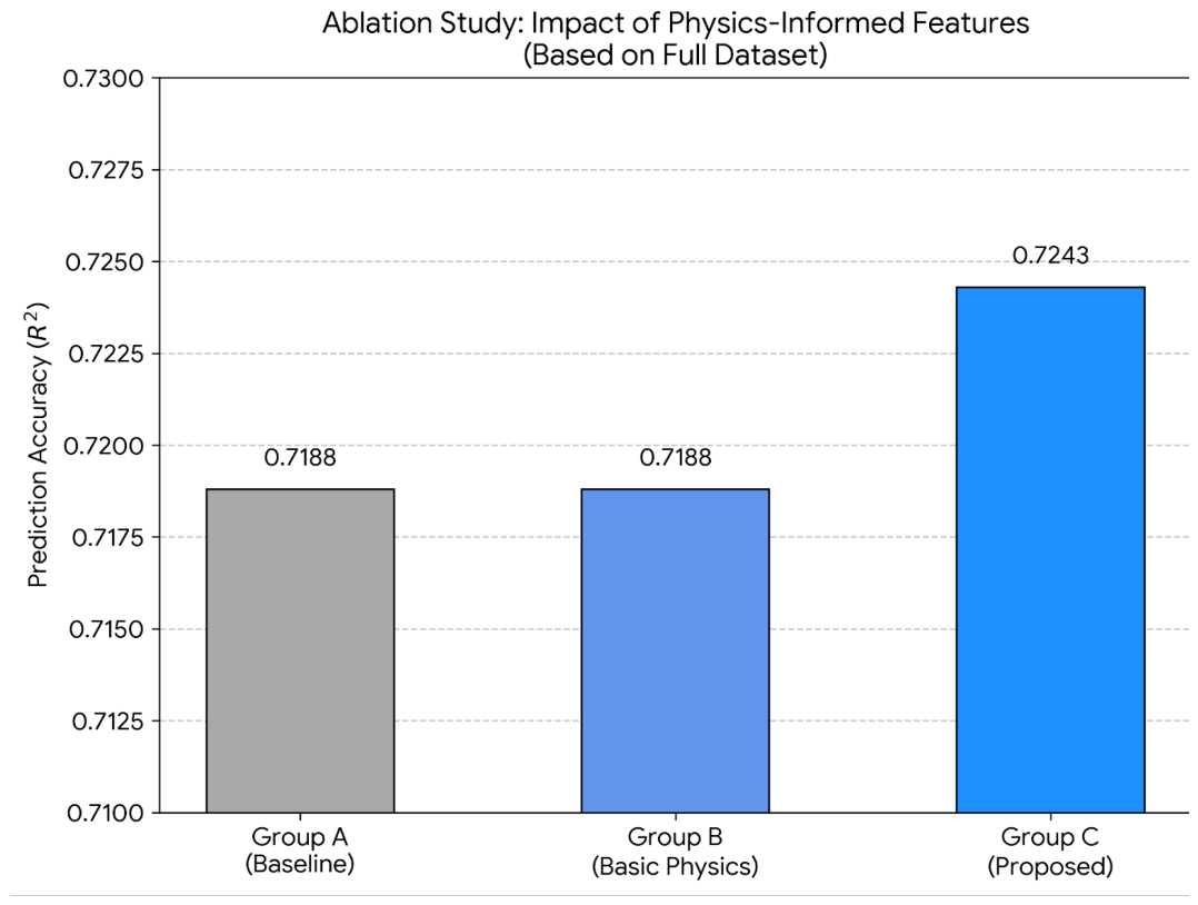
The comparison results of the three experimental configurations are presented in Figure 2. In summary, the prediction performance of the model yields a negligible improvement when adding 3D distance features from Group A to Group B, while the performance of Group C with the height–distance interaction term is significantly enhanced. Specifically, after we deliberately added the interaction term between height and distance in Group C, the model could effectively capture the signal fluctuation situations that simple geometric features (such as only considering distance or only considering height) could not explain. This further demonstrates that the nonlinear correlation between flight altitude and signal path loss is not a trivial secondary factor, but a key determinant of the accuracy of 3D channel modeling. It can also be clearly seen from the figure that, compared with the baseline model that only considers distance, our proposed PIFE method consistently maintains a lower prediction error at all tested flight altitudes.
The Table 1 provides a detailed list of the quantitative indicators for each experimental group, allowing for an intuitive observation of the improvements brought about by the PIFE framework.
Result Discussion:
1.
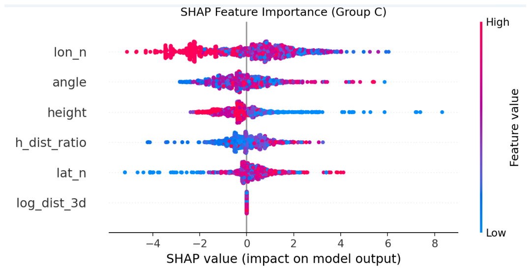
The experimental results show that the predictive performance from Group A to Group B did not exhibit the expected significant improvement. This phenomenon confirms the viewpoint of Shakya et al. [11], that tree models possess a powerful inherent feature-detection capability: at a sufficient depth, XGBoost can implicitly reconstruct the Euclidean distance from the original coordinates. This phenomenon is specific to simple geometric physical priors (e.g., 3D Euclidean distance, logarithmic distance) in Group B, which are low-dimensional and have clear linear correlations with signal attenuation, thus being easily inferred by the tree-splitting mechanism of XGBoost. At this point, introducing explicit distance features additionally becomes redundant. This also partly explains why Nagao et al. [12] were able to achieve a stable and fundamental foundation in the city structure extraction task solely based on coordinate information. In contrast, the complex nonlinear physical coupling features (e.g., the height–distance interaction term in Group C) involve the joint modulation of antenna gain and Fresnel zone clearance, which cannot be autonomously synthesized by the model from a single coordinate feature and must be explicitly constructed as physical informed inputs. The identical performance observed in Group A and Group B (Table 1) does not imply that physical features are redundant; rather, it indicates that simple geometric priors like 3D distance can be implicitly inferred by tree-based models from raw coordinates. However, the significant accuracy gain achieved by Group C confirms that our proposed PIFE framework captures complex, non-linear interaction terms (e.g., the scaling effect of flight altitude on path loss) that the model cannot autonomously learn from coordinates alone, thereby validating the necessity of physics-informed expert knowledge. To further investigate the specific contribution of these interaction terms and address the potential concerns regarding feature redundancy, a SHAP (SHapley Additive exPlanations) analysis was conducted for Group C, as shown in Figure 3. The SHAP results reveal that the interaction terms angle and h_dist_ratio rank as the second and fourth most influential features, respectively. This confirms that while the base distance (Group B) might be redundant for a well-trained XGBoost model, the structural interaction terms introduced in the PIFE framework provide essential non-linear priors that the model’s tree-splitting mechanism cannot autonomously synthesize from raw coordinates. This evidence directly supports the performance leap observed in Group C.
2.
However, when the height–distance interaction term (Group C) is introduced, the model performance breaks the performance bottleneck. This strongly validates the viewpoint of Maeng et al. [16]: the model cannot spontaneously derive the physical modulation effect of antenna radiation patterns. The interaction term successfully injects this crucial prior knowledge, achieving a significant performance gain in accuracy. While the numerical increase in R 2 appears modest, its significance is underscored by the extremely low variance across cross-validation folds (Std. Dev. = 0.0007). This ensures that the PIFE-XGBoost model provides a deterministic rather than stochastic performance gain. Furthermore, the reduction in absolute error (MAE) provides higher reliability for real-time UAV flight control, where link budget precision is non-negotiable.

4.3.2. Robustness Validation

To address the potential issue of overfitting to site-specific noise and rigorously evaluate the generalization capability of the PIFE-XGBoost model, a 10-fold cross-validation was conducted. As shown in Table 2, the proposed model demonstrated a high level of consistency across all data subsets, achieving an average R 2 of 0.7752 with a minimal standard deviation of 0.0169. Furthermore, a paired t-test was performed between the PIFE-XGBoost and the baseline XGBoost (without physics-informed features) across the 10 folds. The test yielded a p-value of 1.72 × 10 5 , which is significantly lower than the standard threshold of 0.05. This result provides robust empirical evidence that the performance gain is statistically significant and that our model captures the underlying physical propagation patterns rather than fluctuating local noise.

4.3.3. Comparative Analysis of Algorithm Performance

To systematically evaluate the effectiveness of the proposed method in this paper, we conducted a comparative analysis of three models. Table 3 summarizes the quantitative evaluation results of each algorithm at four different drone flight heights.
1.
Analysis of the effectiveness of physical perception enhancement: PIFE-XGBoost achieves the lowest MAE at all height levels. Especially at a height of 120 m, its MAE drops to 0.92 dBm. This indicates that the introduction of physical perception features can effectively guide the gradient boosting tree to capture the propagation patterns of signals in three-dimensional space, and its performance is significantly better than traditional neural network models [15] and other adaptive path loss models (such as AMPLE [26]). It is worth noting that while Random Forest (RF) exhibits slightly higher R 2 values at 100 m and 150 m, PIFE-XGBoost consistently achieves the lowest Mean Absolute Error (MAE) across all tested height layers. The slightly lower R 2 of our model at 100 m and 150 m is due to the PIFE framework’s focus on fitting the absolute signal power (consistent with MAE) rather than minimizing the relative variance of predictions (corresponding to R 2 ), which is a deliberate design for UAV link budget optimization. In UAV wireless link modeling, MAE is considered a more decisive metric than R 2 as it reflects the absolute precision of signal power prediction, which is critical for link budget reliability. The slight advantage of RF in R 2 may stem from its bagging mechanism’s ability to smooth localized fluctuations, yet it lacks the absolute accuracy and physical interpretability provided by the PIFE framework. It aligns with the direction of interpretable modeling proposed by [11].
2.
Impact of model complexity: Contrary to the commonly expected “complex models perform better” as stated by Sotiroudis et al. [25], XPBoost combined with Gaussian processes exhibits performance degradation. This result indicates that in the context of drone communication, the forced introduction of stationary Gaussian processes can lead to overfitting of local noise, similar to the generalization bottleneck that Kaur et al. [14] LSTM model may encounter when dealing with non-temporal spatial discrete points. Compared to the computationally expensive Kriging interpolation [27], PIFE-XGBoost achieves a better balance between efficiency and accuracy.
3.
Quantitative Inference Latency: In addition to accuracy, we also measured the inference delay to verify the real-time performance of the model. The benchmarking was conducted on a high-performance host computer equipped with an Intel Core Ultra 9 185H CPU (16 cores, up to 5.1 GHz) and 16 GB of RAM. The experimental results show that the average inference time for each sample of PIFE XGBoost is 6.87 μ s. This microsecond-level response is several orders of magnitude faster than typical deep learning models, confirming that this model does not overfit to local noise and has strong efficiency for real-time drone applications.
4.
Practical Performance Discussion Additionally, the Physical Feature Integration (PIFE) provides meaningful structural bias, which enhances the model’s spatial consistency within diverse aerial altitudes. To evaluate this, a Leave-One-Height-Out (LOHO) test was conducted by training the model on datasets from 70 m, 100 m, and 150 m and testing on the unseen 120 m altitude. This test specifically validates the model’s interpolation capability across the vertical dimension. As shown in Table 4, PIFE-XGBoost (Group C) achieved an R 2 of 0.6725 and an MAE of 1.3146 dBm. Compared to the baseline (Group A, R 2 = 0.6559), the proposed framework demonstrates improved local generalization and higher reliability in predicting signal behaviors at intermediate altitudes where empirical samples are unavailable.
5.
Comparative Analysis with State-of-the-Art (SOTA) Models To further validate the effectiveness of the proposed framework, a comprehensive benchmark was performed on the full dataset. We compared PIFE-XGBoost with representative competitive models, including LightGBM and a data-driven MLP. For a rigorous and fair comparison, all models were evaluated under a standardized 10-fold cross-validation setup with consistent hyperparameters: the LightGBM model was trained with 600 boosting rounds and a learning rate of 0.03; the MLP contained two hidden layers (64 units per layer) optimized with the Adam algorithm; and the Baseline XGBoost shared the same hyperparameters as our proposed model but was limited to raw coordinate inputs only.
As shown in Table 5, the proposed PIFE-XGBoost yields the highest R 2 of 0.7682 and the lowest MAE of 1.2220 dBm, outperforming both the MLP ( R 2 = 0.4122 ) and LightGBM ( R 2 = 0.6788 ) by a clear margin. These results indicate that, for UAV air-to-ground channel modeling, the inclusion of physics-informed feature engineering (PIFE) leads to notably improved predictive performance compared to purely data-driven or deep learning-based alternatives. While the MLP exhibits the lowest latency due to its compact structure, PIFE-XGBoost maintains strong real-time efficiency with an average inference delay of only 6.87 μ s, which satisfies the timing constraints of real-time aerial communication applications.

4.4. Model Interpretability Analysis

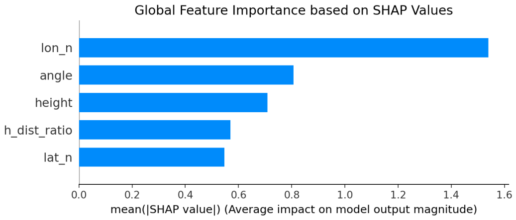
As shown in Figure 4, we employ SHAP values to provide a theoretically grounded interpretation. The results indicate that the physics-informed features, particularly the height-logarithmic distance interaction term ( f i n t e r ) and the antenna orientation-related feature (angle), exhibit significant average absolute SHAP values. This result quantitatively verifies the hypothesis proposed by Zhang et al. [20], suggesting that the path loss exponent in the 3D spatial domain is not a constant but is dynamically modulated by the flight altitude of the UAV. Specifically, the prominent SHAP attribution of f i n t e r indicates that the coupling effect between altitude and horizontal distance captures the transition between Line-of-Sight (LoS) and Non-Line-of-Sight (NLoS) conditions more effectively than individual coordinate features.Meanwhile, while raw coordinates provide essential localization information, the high SHAP rankings of these physically-informed interaction terms prove that the PIFE-XGBoost model effectively prioritizes inherent physical constraints over raw geometric coordinates during the tree-splitting process. By successfully identifying these dominant factors, the model mitigates the risk of overfitting to site-specific noise, thereby enhancing its generalizability across different 3D airspace environments.

4.5. Visual Analysis

4.5.1. Regression Fitting Analysis

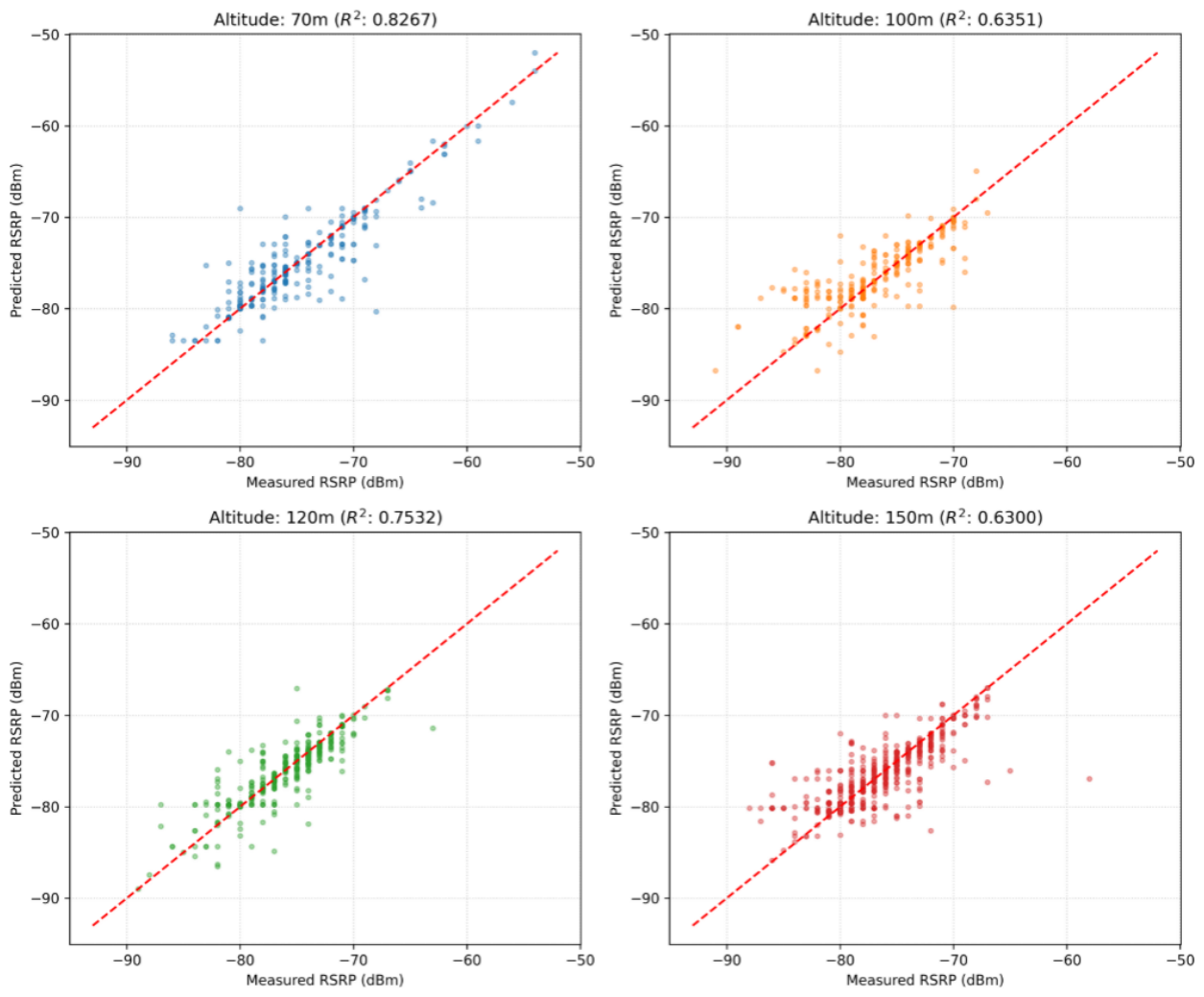
From Figure 5, it can be observed that the model performs robustly across various heights ranging from 70 m to 150 m. The scatter points are concentrated along the 45° reference line, indicating a high consistency between the predicted and measured values. Notably, at the flight altitude of 150 m, despite the significant impact of Fresnel zone effects and ground reflections, the model maintains stable prediction performance, which suggests that it effectively captures 3D spatial propagation characteristics. Residual analysis shows that the error distribution is relatively uniform across the power range. Unlike conventional empirical models, which often exhibit a sharp increase in prediction error for weak signal levels (−100 to −120 dBm), the proposed model demonstrates improved stability in these regions. This enhancement is largely attributed to the height–distance interaction term ( f i n t e r ), which characterizes the complex nonlinear coupling between UAV altitude and propagation distance. Data statistics in Table 3 further support this; while the model achieves its peak performance at 150 m, the R 2 values across all evaluated heights range from 0.625 to 0.843. The slight performance dip at the 100 m level (0.625) is likely due to the increased multipath scattering complexity at intermediate altitudes. Nevertheless, these results demonstrate that PIFE-XGBoost effectively incorporates physical prior knowledge rather than relying on blind data fitting. By mitigating the systematic deviations commonly observed in 3D radio environment map modeling, this framework provides a solid foundation for applications such as UAV path planning and resource allocation. It is worth noting that this stable performance is based on large-scale path loss. Future work could integrate temporal features to further capture small-scale fading and signal fluctuations induced by dynamic blockages. It should be noted that the current evaluation is conducted in a single urban scenario with stable flight conditions, and further validation in more complex environments is required to verify the generalizability of the proposed framework.

4.5.2. Spatial Distribution Reconstruction

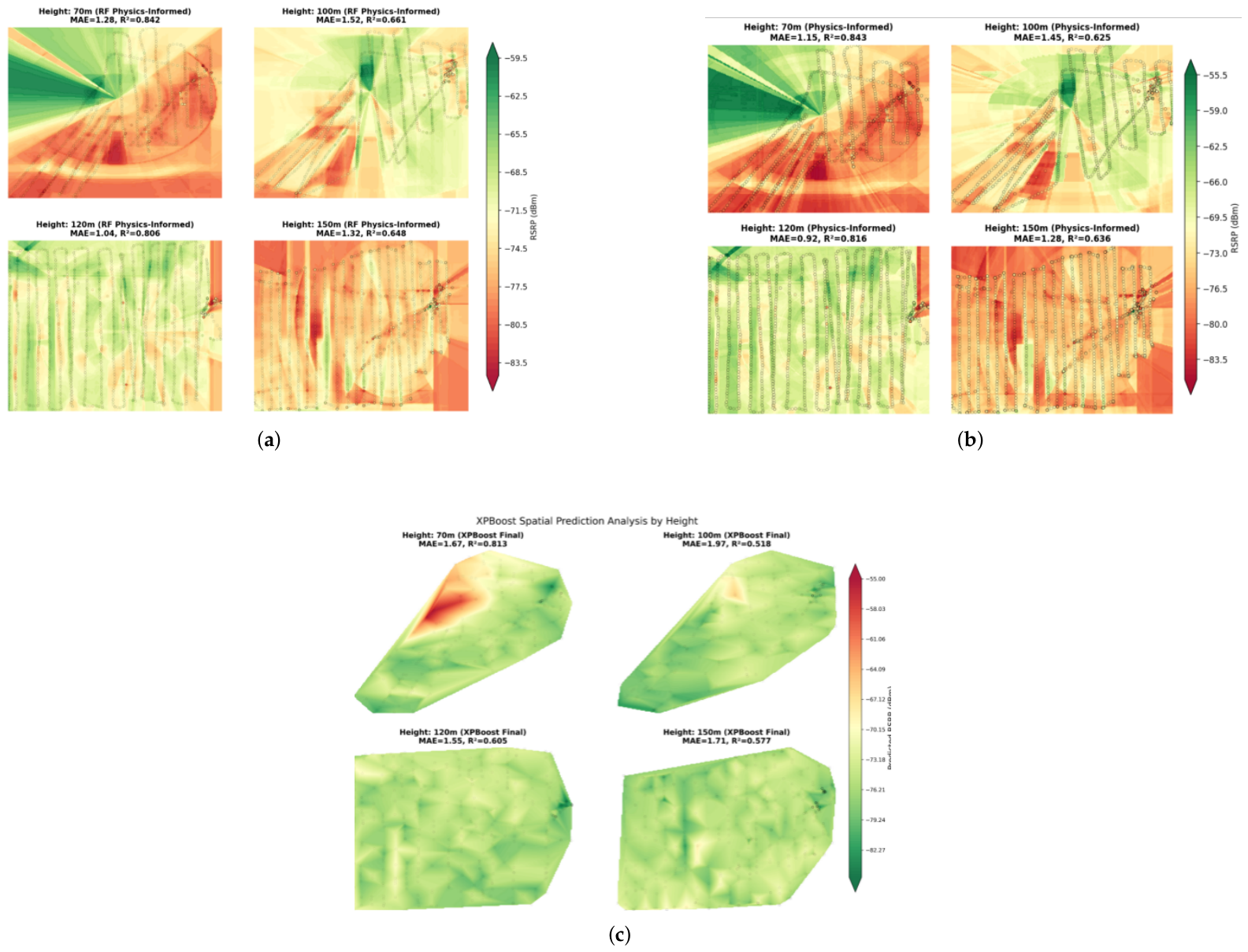
Relying exclusively on regression metrics is insufficient for a comprehensive evaluation of model performance. In practical deployment, the spatial coherence and physical consistency of the signal heat map serve as a critical validation criterion. To evaluate the capability of the PIFE-XGBoost model to accurately represent the spatial distribution of signal strength, a multi-altitude comparison of the predicted heat maps was conducted (Figure 6), alongside a comparison with baseline models.
Physical Consistency
The predicted graph generated by PIFE-XGBoost appears very smooth, with the signal gradually weakening in a circular pattern from the center. This smooth signal attenuation transition is highly consistent with the theoretical signal propagation law specified in [4].
Further analysis shows that this spatial smoothness is not an artificial fitting result of the model, but a direct consequence of the embedded physical propagation priors in the feature engineering. The model does not simply memorize the spatial correlation of sample data, but effectively captures the propagation characteristics of electromagnetic waves in the air. In practical applications, this smooth prediction is extremely valuable—it enables drones to switch between different areas more stably, avoiding the frequent handover between adjacent base stations, thereby ensuring the stability of UAV air-to-ground communication links.
Comparative Analysis
In contrast, the signal heat map generated by the standard XGBoost model (see Figure 6c) exhibits poor spatial continuity. The heat map exhibits discrete isolated signal regions with obvious spatial fragmentation. This indicates that the standard XGBoost model suffers from overfitting, which misidentifies random environmental noise as valid signal propagation patterns. This is precisely the overfitting problem that many complex models are prone to. This phenomenon confirms Sotirudis’s [25] concern about high complexity models.
This discrete spatial distribution is inconsistent with the fundamental physical laws of wireless signal propagation. A pure data-driven algorithm cannot effectively adapt to the complex 3D spatial environment of UAV flight. During actual flights, this artificial signal is very dangerous: if the UAV navigates to the regions predicted as high-quality signal areas by the model (essentially noise points), the actual communication link will be interrupted, which may lead to loss of UAV control.

5. Conclusions and Future Work

5.1. Research Conclusions

The air-to-ground communication signal of UAVs exhibits inherent non-stationarity and dynamic variability, making accurate 3D spatial signal strength prediction a long-standing challenge in the field. For this reason, we propose the PIFE-XGBoost method, which overcomes the inflexibility of traditional empirical models and the poor interpretability of pure data-driven machine learning models (black-box models). We put real physical laws, such as signal attenuation and antenna angle influence in 3D space, directly into the model, enabling the model to integrate data-driven fitting with physics-based mechanism understanding, instead of performing blind data fitting without physical priors. This aligns with the important research direction of interpretable artificial intelligence in the field of wireless communications. Based on our measured data at four heights of 70 m, 100 m, 120 m and 150 m, the following conclusions are drawn in this study:
1.
Our PIFE-XGBoost model demonstrated superior predictive accuracy across all evaluation altitudes, peaking at 120 m with a Mean Absolute Error (MAE) of 0.92 dBm and an R 2 of 0.816. This performance marks a substantial improvement over the Random Forest baseline (MAE = 1.04 dBm), consistent with the altitude-dependent channel dynamics analyzed by Zhang et al. [20]. By integrating physical constraints as explicit features, the proposed method successfully decoupled the nonlinear interactions between flight height and 3D propagation distance, effectively capturing the gain variations of the antenna’s main lobe.
2.
A comparative analysis with the Gaussian Process (GP)-enhanced XGBoost model shows that increasing model complexity does not yield better performance, but instead leads to performance degradation. At the height of 120 m, the error MAE even rises to 1.55 dBm. Although the Gaussian Process (GP) is theoretically suitable for processing spatially correlated signals, the visualization results show that it is prone to overfitting to local environmental noise in the complex dynamic 3D UAV flight environment, resulting in discontinuous and physically inconsistent predicted signal distributions. This also confirms the previous finding [8,25] that the more complex the model, the worse the generalization ability.
3.
The analysis of feature importance indicates that the constructed height–distance interaction term contributes the most to the model’s prediction gain. This confirms that the model has successfully transitioned from “mechanical memory” of geographic coordinates to “understanding” of propagation physical mechanisms, aligning with the trustworthy AI criteria proposed by Gholami et al. [28] in 3D channel modeling. This transition ensures that the model maintains high robustness in high-altitude sparse sampling areas (such as 150 m), without the common performance collapse observed in purely data-driven models.

5.2. Future Outlook

Although the framework proposed in this paper has achieved satisfactory results, the complexity of the drone communication environment indicates that there is still ample room for further research. Future work will focus on the following three directions.

5.2.1. Joint Modeling of Large-Scale Path Loss and Small-Scale Fading

Current research only focuses on predicting large-scale path loss of UAV 3D airspace signals, without considering small-scale fading effects (multipath interference, Doppler shift) and signal attenuation caused by UAV maneuvering and obstacles, which are key factors affecting the actual communication quality of UAVs. In future research, we will integrate high-frequency sampled data of channel state information (CSI) to extract features of small-scale fading, and construct a joint prediction model of large-scale path loss and small-scale fading by combining PIFE spatial features with time-domain dynamic features (e.g., UAV flight speed, acceleration, attitude angles). At the same time, introducing blockage state indicators (such as LoS/NLoS determination based on high path ratio, antenna shielding coefficient) in the PIFE framework to characterize the signal attenuation pattern under UAV maneuvering and physical blockage conditions, improving the model’s adaptability to complex real flight scenarios.

5.2.2. Environmental Generalization Test

The current experiment is based on a specific open suburban environment. Considering that 3GPP TR 38.901 [4] defines a diverse range of channel models, we plan to test the PIFE framework in complex scenarios such as dense urban areas (Urban Micro, UMi) in the future. We intend to draw on the experience of Rekkas et al. [29] and Chen et al. [30] in the construction of Radio Environment Maps (REM), focusing on verifying whether physical feature engineering can still maintain its “denoising” and “correction” capabilities in severe multipath effects and building obstruction environments, in order to enhance the model’s cross-scenario generalization level.

5.2.3. Real-Time Edge Deployment

Given that XGBoost has significantly lower computational overhead compared to GP models, it has the potential to run on resource-constrained devices. The next step is to perform lightweight pruning on the trained model and directly deploy it to drone embedded processors (such as Raspberry Pi or NVIDIA Jetson Nano). This will provide millisecond-level computational support for real-time QoS prediction proposed by Purucker et al. [31], enabling drones to no longer rely on post-processing computations on the ground.

5.2.4. Signal Perception and Trajectory Planning

Based on the high-precision prediction model presented in this paper, we attempt to integrate it with the drone navigation system to explore “signal perception trajectory planning” [17]. This allows drones to actively avoid signal blind spots by utilizing the thermal map predicted by PIFE-XGBoost when performing inspection or data transmission tasks. Furthermore, in the future, we can introduce Graph Neural Network (GNN) technology proposed by Shibli et al. [32] and Tonchev et al. [33] to further capture spatial dependencies under complex topological structures, thereby achieving joint optimization of communication quality and flight energy consumption.

Author Contributions

Conceptualization, L.L.; methodology, L.L., Y.W., S.-K.I. and X.C.; software, L.L. and X.Y.; validation, L.L. and X.C.; formal analysis, L.L. and X.Y.; investigation, L.L., H.G. and J.C.; resources, L.H.; data curation, L.L. and L.H.; writing—original draft preparation, L.L., Y.W. and X.Y.; writing—review and editing, Y.W. and X.Y.; visualization, L.L.; supervision, Y.W., X.Y. and S.-K.I.; project administration, Y.W., S.-K.I. and X.C.; funding acquisition, Y.W. All authors have read and agreed to the published version of the manuscript.

Funding

This work was funded by Macao Science and Technology Development Fund (FDCT-MOST joint project No. 0018/2025/AMJ) and Macao Polytechnic University (RP/FCA-01/2025).

Institutional Review Board Statement

Not applicable.

Informed Consent Statement

Not applicable.

Data Availability Statement

The data presented in this study are available on request from the corresponding author. (Since our data were collected in Macao, China, they contain sensitive geographic information (latitude and longitude), so the dataset is not publicly available.)

Conflicts of Interest

Author Lu Huang was employed by the Technology RD Department, WellWin Technology Limited. The remaining authors declare that the research was conducted in the absence of any commercial or financial relationships that could be construed as a potential conflict of interest.

References

  1. Geraci, G.; Garcia-Rodriguez, A.; Azari, M.M.; Lozano, A.; Mezzavilla, M.; Chatzinotas, S.; Chen, Y.; Rangan, S.; Di Renzo, M. What will the future of UAV cellular communications be? A flight from 5G to 6G. IEEE Commun. Surv. Tutor. 2022, 24, 1304–1335. [Google Scholar] [CrossRef]
  2. 3GPP. Study on enhanced LTE support for aerial vehicles. In Technical Report (TR) 36.777, V15.0.0, 3rd Generation Partnership Project (3GPP); 3GPP: Sophia Antipolis, France, 2017. [Google Scholar]
  3. Hao, H.; Xu, C.; Zhang, W.; Chen, X.; Yang, S.; Muntean, G.-M. Reliability-Aware Optimization of Task Offloading for UAV-Assisted Edge Computing. IEEE Trans. Comput. 2025, 74, 3832–3844. [Google Scholar] [CrossRef]
  4. 3GPP. Study on channel model for frequencies from 0.5 to 100 GHz. In Technical Report (TR) 38.901, V16.1.0, 3rd Generation Partnership Project (3GPP); 3GPP: Sophia Antipolis, France, 2019. [Google Scholar]
  5. Mozaffari, M.; Saad, W.; Bennis, M.; Nam, Y.H.; Debbah, M. A tutorial on UAVs for wireless networks: Applications, challenges, and open problems. IEEE Commun. Surv. Tutor. 2019, 21, 2334–2360. [Google Scholar] [CrossRef]
  6. Khuwaja, A.A.; Chen, Y.; Zhao, N.; Alouini, M.S.; Dobbins, P. A survey of channel modeling for UAV communications. IEEE Commun. Surv. Tutor. 2018, 20, 2804–2821. [Google Scholar] [CrossRef]
  7. Auer, S.; Zhu, X.; Hinz, S.; Bamler, R. 3D analysis of scattering effects based on Ray Tracing techniques. In Proceedings of the 2009 IEEE International Geoscience and Remote Sensing Symposium; IEEE: Piscataway, NJ, USA, 2009; Volume 3, pp. III-17–III-20. [Google Scholar]
  8. Tang, Z.; Zhao, H.; Zhang, J.; Wu, H.; Wang, J. Digital twin-enabled task-driven UAV communications under uncertainty. IEEE Trans. Veh. Technol. 2025, 74, 8454–8459. [Google Scholar]
  9. Sani, U.S.; Malik, O.A.; Lai, D.T.C. Improving Path Loss Prediction Using Environmental Feature Extraction from Satellite Images: Hand-Crafted vs. Convolutional Neural Network. Appl. Sci. 2022, 12, 7685. [Google Scholar] [CrossRef]
  10. Zhang, J.; Liu, Y.; Wang, X. Transformer-Based Air-to-Ground mmWave Channel Characteristics Prediction for 6G UAV Communications. Sensors 2025, 25, 3731. [Google Scholar]
  11. Shakya, I.L.; Rezazadeh, F.; Chergui, H.; Verikoukis, C. Explainable AI in 6G O-RAN: A tutorial and survey on architecture, use cases, challenges, and future research. IEEE Commun. Surv. Tutor. 2024, 26, 2489–2535. [Google Scholar]
  12. Nagao, T.; Hayashi, T. A study on urban structure map extraction for radio propagation prediction using XGBoost. In Proceedings of the 15th European Conference on Antennas and Propagation (EuCAP), Dusseldorf, Germany, 22–26 March 2021; IEEE: Piscataway, NJ, USA, 2021; pp. 1–5. [Google Scholar]
  13. Al-Hourani, A.; Kandeepan, S.; Lardner, S. Optimal LAP altitude for maximum coverage. IEEE Wirel. Commun. Lett. 2014, 3, 569–572. [Google Scholar] [CrossRef]
  14. Kaur, G.; Goyal, R.K.; Mehta, R. An efficient handover mechanism for 5G networks using hybridization of LSTM and SVM. Multimedia Tools Appl. 2022, 81, 37057–37085. [Google Scholar] [CrossRef]
  15. Ostlin, E.; Zepernick, H.J.; Suzuki, H. Macrocell path-loss prediction using artificial neural networks. IEEE Trans. Veh. Technol. 2010, 59, 2735–2747. [Google Scholar] [CrossRef]
  16. Maeng, S.J.; Kwon, H.; Ozdemir, O.; Guvenc, I. Impact of 3-D antenna radiation pattern in UAV air-to-ground path loss modeling and RSRP-based localization in rural area. IEEE Open J. Antennas Propag. 2023, 4, 124–138. [Google Scholar] [CrossRef]
  17. Zeng, Y.; Zhang, R.; Lim, T.J. Energy-efficient UAV communication with trajectory optimization. IEEE Trans. Wirel. Commun. 2017, 16, 3747–3760. [Google Scholar] [CrossRef]
  18. Al-Hourani, A.; Gomez, K.; Kandeepan, S. Modeling cellular-to-UAV path-loss for suburban environments. IEEE Wirel. Commun. Lett. 2018, 7, 82–85. [Google Scholar] [CrossRef]
  19. Hata, M. Empirical formula for propagation loss in land mobile radio services. IEEE Trans. Veh. Technol. 2010, 29, 317–325. [Google Scholar] [CrossRef]
  20. Zhang, X.; Andrews, J.G. Downlink cellular network analysis with multi-slope path loss models. IEEE Trans. Commun. 2015, 63, 1881–1894. [Google Scholar] [CrossRef]
  21. Chen, T.; Guestrin, C. XGBoost: A scalable tree boosting system. In Proceedings of the 22nd ACM SIGKDD International Conference on Knowledge Discovery and Data Mining, San Francisco, CA, USA, 13–17 August 2016; Association for Computing Machinery: New York, NY, USA, 2016; pp. 785–794. [Google Scholar]
  22. Saad, W.; Bennis, M.; Chen, M. A vision of 6G wireless systems: Applications, trends, technologies, and open research problems. IEEE Netw. 2020, 34, 134–142. [Google Scholar] [CrossRef]
  23. Matolak, D.W.; Sun, R. Air-ground channel characterization for unmanned aircraft systems—Part I: Methods, measurements, and models for over-water settings. IEEE Trans. Veh. Technol. 2017, 66, 26–44. [Google Scholar] [CrossRef]
  24. Gustafson, C.; Abbas, T.; Bolin, D.; Tufvesson, F. Statistical modeling and estimation of censored pathloss data. IEEE Wirel. Commun. Lett. 2015, 4, 569–572. [Google Scholar] [CrossRef]
  25. Sotiroudis, S.P.; Goudos, S.K.; Siakavara, K. Neural networks and random forests: A comparison regarding prediction of propagation path loss for NB-IoT networks. In Proceedings of the 8th International Conference on Modern Circuits and Systems Technologies (MOCAST), Thessaloniki, Greece, 13–15 May 2019; IEEE: Piscataway, NJ, USA, 2019; pp. 1–4. [Google Scholar]
  26. Zhou, L.; Zhang, J.; Zhang, J.; Cetinkaya, O.; Jubb, S.A. AMPLE: An adaptive multiple path loss exponent radio propagation model considering environmental factors. IEEE Trans. Veh. Technol. 2025, 74, 3395–3408. [Google Scholar] [CrossRef]
  27. Yamada, S.; Fujii, T. Performance analysis of 3D radio environment mapping with path classification and Kriging. In Proceedings of the IEEE Consumer Communications and Networking Conference (CCNC), Las Vegas, NV, USA, 10–13 January 2025; IEEE: Piscataway, NJ, USA, 2025; pp. 1–6. [Google Scholar]
  28. Gholami, L.; Ducange, P.; Gotta, A.; Cassará, P. Leveraging explainable AI for 3D geometry-based channel status prediction in UAV-assisted communication networks. IEEE Open J. Commun. Soc. 2025, 6, 885–899. [Google Scholar] [CrossRef]
  29. Rekkas, V.P.; Sotiroudis, S.P.; Zaharis, Z.D.; Koudouridis, G.P.; Sarigiannidis, P.; Karagiannidis, G.K.; Christodoulou, C.G.; Goudos, S.K. Machine learning based radio environment maps for 4G/5G networks. IEEE Trans. Antennas Propag. 2025, 73, 10529–10543. [Google Scholar] [CrossRef]
  30. Chen, X.; Zhong, X.; Zhang, Z.; Dai, L.; Zhou, S. High-efficiency urban 3D radio map estimation based on sparse measurements. IEEE Trans. Veh. Technol. 2025, 74, 16488–16503. [Google Scholar] [CrossRef]
  31. Purucker, P.; Reil, C.; Höß, A.; Schuller, B.W. Deep neural quality of service prediction for unmanned aircraft system communications. In Proceedings of the International Wireless Communications and Mobile Computing Conference (IWCMC), Ayia Napa, Cyprus, 27–31 May 2024; IEEE: Piscataway, NJ, USA, 2024; pp. 605–610. [Google Scholar]
  32. Shibli, A.; Zanouda, T. Data-driven radio environment map estimation using graph neural networks. In Proceedings of the IEEE ICC Workshops, Denver, CO, USA, 8–12 June 2024; IEEE: Piscataway, NJ, USA, 2024; pp. 1–6. [Google Scholar]
  33. Tonchev, K.; Ivanov, A.; Neshov, N.; Manolova, A.; Poulkov, V. Learning graph convolutional neural networks to predict radio environment maps. In Proceedings of the 25th International Symposium on Wireless Personal Multimedia Communications (WPMC), Heraklion, Greece, 30 October–2 November 2022; IEEE: Piscataway, NJ, USA, 2022; pp. 60–65. [Google Scholar]
Figure 1. The experimental hardware platform deployed in Seac Pai Van, Macau. The system consists of a DJI Matrice 350 RTK drone integrated with the mobile measurement terminal, ready for multi-altitude data acquisition tasks.
Mathematics 14 01399 g001
Figure 2. In the performance comparison of ablation research, Group C has achieved performance improvement after introducing interactive items.
Mathematics 14 01399 g002
Figure 3. SHAP summary plot for the PIFE-XGBoost model (Group C), illustrating the importance of interactive physical features.
Mathematics 14 01399 g003
Figure 4. Global feature importance analysis of PIFE-XGBoost. Feature importance is quantified to align with the SHAP framework to ensure consistency in physical interpretation.
Mathematics 14 01399 g004
Figure 5. Regression fitting plot of RSRP predicted values and actual values.
Mathematics 14 01399 g005
Figure 6. (a) Random forest model. (b) PIFE-XGBoost model. (c) XPBoost model.
Mathematics 14 01399 g006
Table 1. Comparison of ablation experiment results.
Experimental Group R 2 RMSE (dBm)MAE (dBm)
Group A (Baseline)0.71882.17891.3526
Group B (Basic Physics)0.71882.17891.3526
Group C (Proposed PIFE)0.72432.15731.3373
Table 2. Detailed performance comparison between Baseline XGBoost and PIFE-XGBoost based on 10-fold cross-validation.
Fold IndexBaseline XGBoost (MAE)PIFE-XGBoost (Proposed)Improvement
Fold 11.34621.208510.20%
Fold 21.39691.25959.80%
Fold 31.25691.110711.60%
Fold 41.45181.243214.30%
Fold 51.37261.189613.30%
Fold 61.28551.115213.20%
Fold 71.37801.226511.00%
Fold 81.37401.190713.30%
Fold 91.35121.213210.20%
Fold 101.34591.200110.80%
Average1.35591.195711.80%
p-value- 1.72 × 10 5 Significant
Table 3. Performance comparison of different algorithms under multiple height layers.
HeightMetricRandom ForestPIFE-XGBoostXPBoost (w/GP)
70 m R 2 0.8420.8430.813
MAE (dBm)1.281.151.67
100 m R 2 0.6610.6250.518
MAE (dBm)1.521.451.97
120 m R 2 0.8060.8160.605
MAE (dBm)1.040.921.55
150 m R 2 0.6480.6360.577
MAE (dBm)1.321.281.71
Table 4. Generalization performance on unseen altitude (120 m) under Leave-One-Height-Out (LOHO) validation.
Model Group R 2 MAE (dBm)RMSE (dBm)
Group A (Baseline)0.65591.34001.8392
Group C (Proposed PIFE)0.67251.31461.7944
Table 5. Comprehensive Performance Comparison with SOTA Models (10-Fold CV).
ModelTypeAvg. R 2 Avg. MAE (dBm)Latency ( μ s)
PIFE-XGBoost (Proposed)Proposed0.76821.19576.867
Baseline XGBoostAblation0.75941.33595.711
LightGBMSOTA Tree0.67881.63036.195
MLP (Deep Learning)SOTA DL0.41222.32070.721
Disclaimer/Publisher’s Note: The statements, opinions and data contained in all publications are solely those of the individual author(s) and contributor(s) and not of MDPI and/or the editor(s). MDPI and/or the editor(s) disclaim responsibility for any injury to people or property resulting from any ideas, methods, instructions or products referred to in the content.