

Understanding Maritime Traffic Complexity: A Comprehensive Concept Development Review


Abstract
1. Introduction
1.1. History and Understanding of MTC
1.2. Contemporary Definitions and Regulatory Framework of MTC
2. Materials and Methods
- Maritime/marine traffic complexity (trivial);
- Maritime traffic flow complexity;
- Waterway complexity;
- Maritime traffic density;
- Collision probability.
2.1. Literature Review Methodology
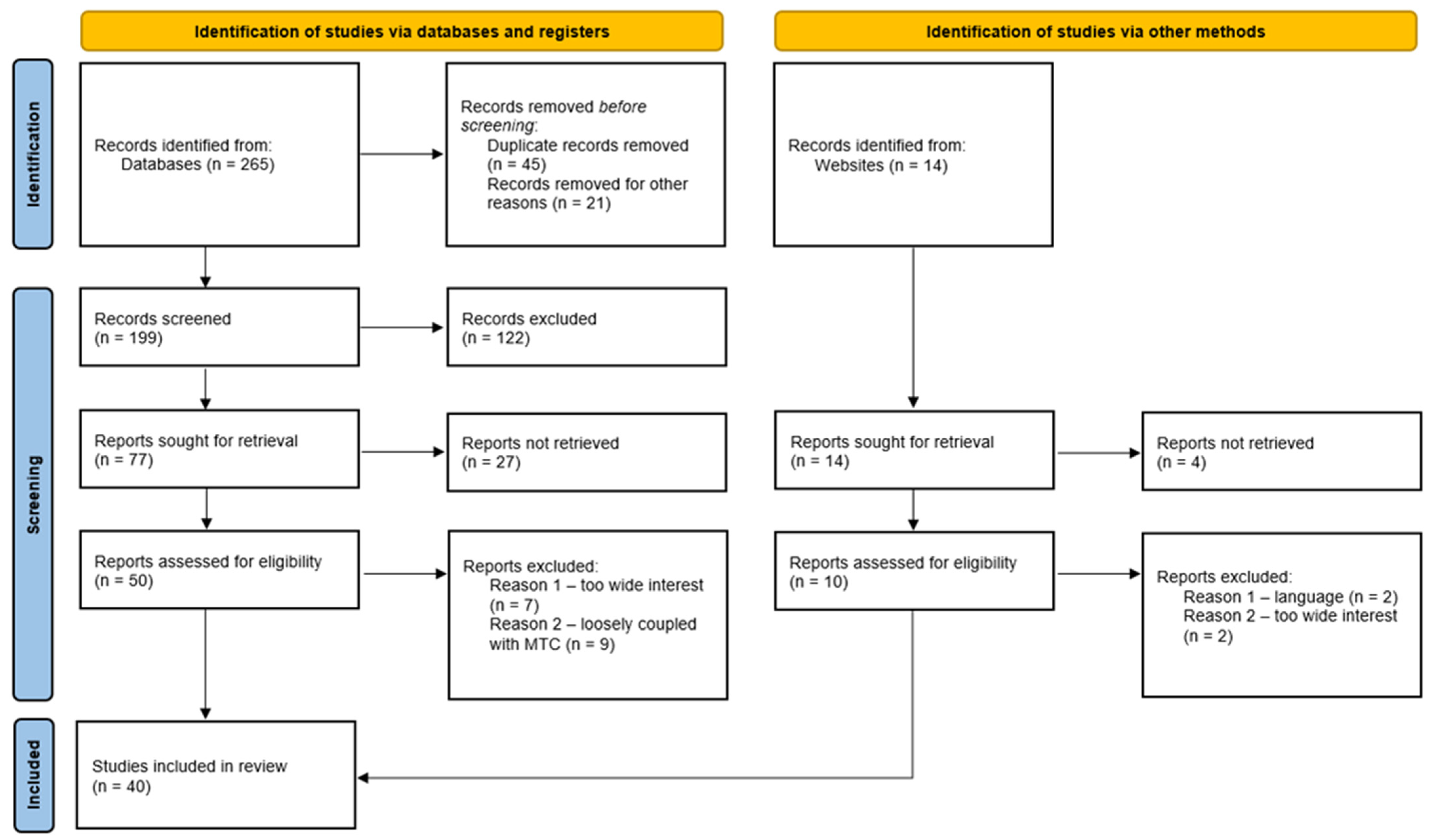
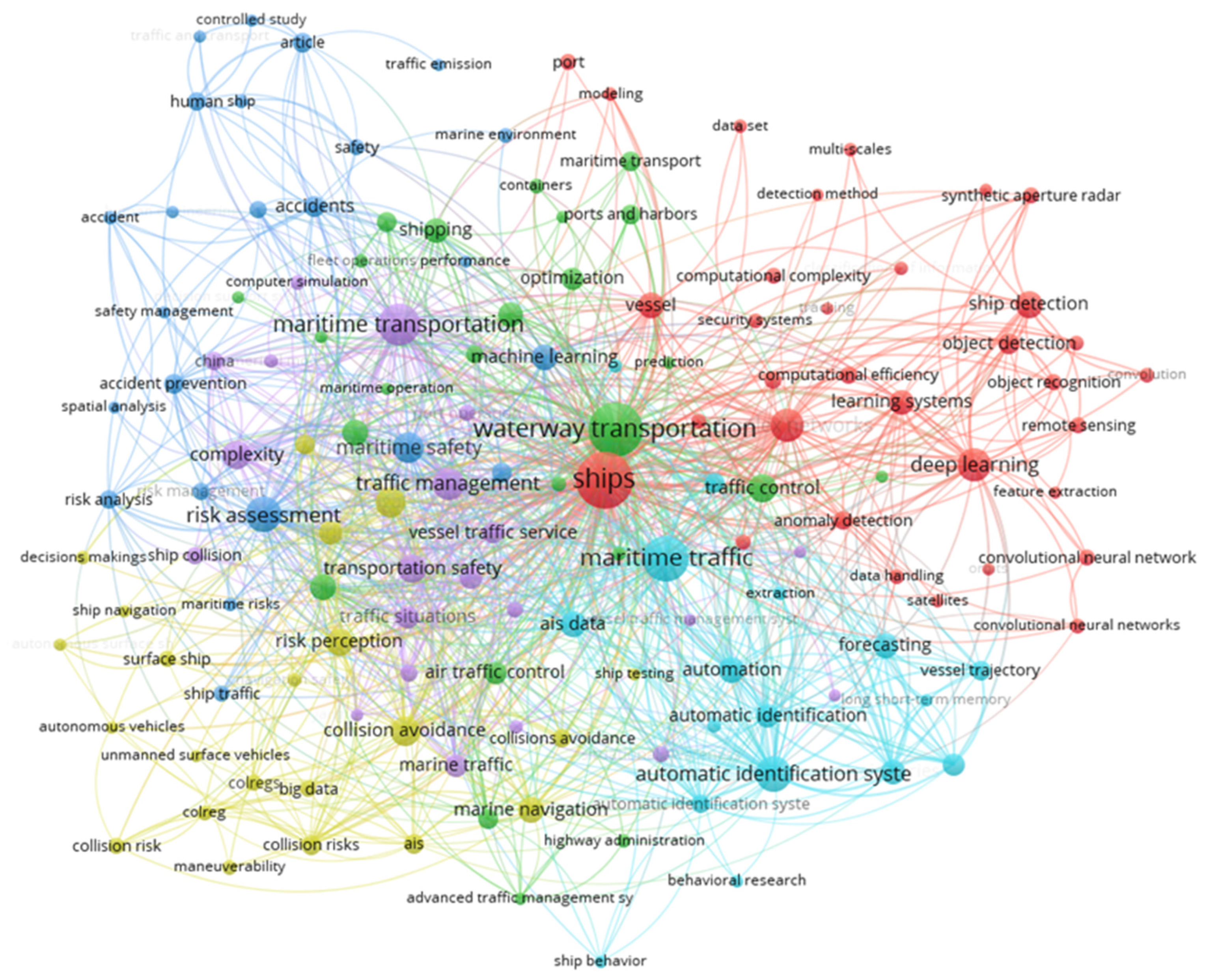
- Step 1: Identification of relevant scientific papers. The search process began with the selection of appropriate keywords to retrieve literature related to the term MTC from scientific databases. After defining the scope of the study, the keywords were identified with the help of VOSviewer as explained earlier. This initial search resulted in 265 identified records, as illustrated in Figure 2.
- Step 2: Screening of identified records. The screening phase aimed to determine which studies were pertinent to the research while excluding those outside the primary focus. Titles, abstracts, and conclusions were reviewed, and the main text was briefly examined when necessary. Full-text evaluation was performed only for articles directly addressing MTC and maritime safety. Duplicate entries were removed, and some potentially relevant but inaccessible studies were excluded. Following this stage, 199 papers remained, corresponding to a retention rate of approximately 75%.
- Step 3: Eligibility assessment. During this stage, the screened papers underwent detailed examination to determine their suitability for further analysis. Only the most significant contributions were retained to support a comprehensive understanding of the field and to provide sufficient material for bibliometric evaluation. These sources were various, including journal articles, conference papers, PhD dissertations, MSc theses, and other related scientific work that engage directly and substantively the concept of MTC. Works proposing or evaluating MTC frameworks, conducting comprehensive reviews of the concept of MTC, or presenting rigorous and in-depth investigations into related aspects of the topic. Brief concept papers or works addressing MTC only tangentially were excluded. This process reduced the dataset to 77 papers, representing a retention rate of about 39% from the screened records.
- Step 4: Analysis of the included studies. The literature retrieval process concluded with the final selection of 40 papers for inclusion in the review. These studies were examined in full to capture their findings, insights, and implications, thereby establishing a robust foundation for the subsequent bibliometric analysis [25,26].
2.2. Bibliometric Analysis Description
3. Results
3.1. Main Methodologies, Research Directions, and Implications of MTC Models
3.2. Bibliometric Analysis
4. Discussion
5. Conclusions
Supplementary Materials
Author Contributions
Funding
Data Availability Statement
Conflicts of Interest
Abbreviations
| AIS | Automatic Identification System |
| Bi-LSTM | Bidirectional Long Short-Term Memory |
| COG | Course Over Ground |
| COLREGs | International Regulations for Preventing Collisions at Sea |
| CS-TCI | Complexity-Aware Course–Speed |
| DCPA | Distance at Closest Point of Approach |
| DSS | Decision Support Systems |
| GT | Gross Tonnage |
| IF-MABAC | Fuzzy Multi-Attribute Boundary Approximation Area Comparison |
| IMO | International Maritime Organization |
| LOA | Length Over All |
| MASS | Maritime Autonomous Surface Ships |
| MTC | Maritime Traffic Complexity |
| OOW | Officer of the Watch |
| OWF | Offshore Wind Farm |
| PCA | Principal Component Analysis |
| PSC | Port State Control |
| PhD | Doctor of Philosophy |
| PRISMA | Preferred Reporting Items for Systematic Reviews and Meta-Analyses |
| QSD | Quaternion Ship Domain |
| R-MTSCN | Rule-based Marine Traffic Situation Complex Network |
| RDF | Radial Distribution Function |
| SD | Ship Domain |
| SLR | Systematic Literature Review |
| Soft-DTW | Soft Dynamic Time Warping |
| SOG | Speed Over Ground |
| SOLAS | International Convention for the Safety of Life at Sea |
| TCPA | Time to Closest Point of Approach |
| TOPSIS | Technique for Order Preference by Similarity to an Ideal Solution |
| TSS | Traffic Separation Scheme |
| VTS | Vessel Traffic Service |
| VTSOs | Vessel Traffic Service Operators |
| WoS | Web of Science |
References
- Helbing, D. Traffic and related self-driven many-particle systems. Rev. Mod. Phys. 2001, 73, 1067–1141. [Google Scholar] [CrossRef] [Scilit]
- Ducruet, C.; Notteboom, T. The worldwide maritime network of container shipping: Spatial structure and regional dynamics. Glob. Netw. 2012, 12, 395–423. [Google Scholar] [CrossRef] [Scilit]
- Kaluza, P.; Kölzsch, A.; Gastner, M.T.; Blasius, B. The complex network of global cargo ship movements. J. R. Soc. Interface 2010, 7, 1093–1103. [Google Scholar] [CrossRef] [Scilit] [PubMed]
- Laudeman, I.V.; Shelden, S.G.; Branstrom, R.; Brasil, C.L. Dynamic Density: An Air Traffic Management Metric; NASA: Washington, DC, USA, 1998. [Google Scholar]
- Histon, J.M. Mitigating Complexity in Air Traffic Control: The Role of Structure-Based Abstractions. Doctoral Thesis, Massachusetts Institute of Technology, Cambridge, MA, USA, 2008. [Google Scholar]
- Xin, X.; Liu, K.; Yang, Z. Maritime traffic complexity evaluation in complex waters. In Advances in Reliability, Safety and Security; Kolowrocki, Dabrowska, Eds.; Polish Safety and Reliability Association: Gdynia, Poland, 2024. [Google Scholar]
- Xin, X.; Liu, K.; Liu, J.; Wang, W.; Yang, Z. Modeling, evaluation, and mitigation of maritime traffic complexity in complex waters. IEEE Trans. Intell. Transp. Syst. 2025, 26, 13275–13292. [Google Scholar] [CrossRef] [Scilit]
- Xin, X.; Yang, Z.; Liu, K.; Zhang, J.; Wu, X. Multi-stage and multi-topology analysis of ship traffic complexity for probabilistic collision detection. Expert Syst. Appl. 2023, 213, 118890. [Google Scholar] [CrossRef] [Scilit]
- Xin, X.; Liu, K.; Loughney, S.; Wang, J.; Li, H.; Ekere, N.; Yang, Z. Multi-scale collision risk estimation for maritime traffic in complex port waters. Reliab. Eng. Syst. Saf. 2023, 240, 109554. [Google Scholar] [CrossRef] [Scilit]
- Tu, E.; Zhang, G.; Rachmawati, L.; Rajabally, E.; Huang, G.B. Exploiting AIS data for intelligent maritime navigation: A comprehensive survey. arXiv 2016, arXiv:1606.00981. [Google Scholar] [CrossRef] [Scilit]
- Singh, S.K.; Heymann, F. Machine learning-assisted anomaly detection in maritime navigation using AIS data. arXiv 2002, arXiv:2002.05013. [Google Scholar] [CrossRef] [Scilit]
- Liu, D.; Rong, H.; Guedes Soares, C. Shipping route modelling of AIS maritime traffic data at the approach to ports. Ocean Eng. 2023, 289, 115868. [Google Scholar] [CrossRef] [Scilit]
- Pallotta, G.; Vespe, M.; Bryan, K. Vessel pattern knowledge discovery from AIS data: A framework for anomaly detection and route prediction. Entropy 2013, 15, 2218–2245. [Google Scholar] [CrossRef] [Scilit]
- IMO. Resolution A.857(20)—Guidelines for Vessel Traffic Services; International Maritime Organization: London, UK, 1997. [Google Scholar]
- IMO. COLREG: Convention on the International Regulations for Preventing Collisions at Sea, Resolution A.1085(28); International Maritime Organization: London, UK, 2013. [Google Scholar]
- IMO. SOLAS: International Convention for the Safety of Life at Sea, 1974, as Amended—Consolidated Edition 2024; International Maritime Organization: London, UK, 2024. [Google Scholar]
- Bojić, F.; Gudelj, A.; Bošnjak, R. Port-related shipping gas emissions—A systematic review of research. Appl. Sci. 2022, 12, 3603. [Google Scholar] [CrossRef] [Scilit]
- Boko, Z.; Skoko, I.; Sanchez Varela, Z.; Milin, V. Advancing maritime safety: A literature review on machine learning and multi-criteria analysis in PSC inspections. J. Mar. Sci. Eng. 2025, 13, 974. [Google Scholar] [CrossRef] [Scilit]
- Glavinović, R.; Vukić, L.; Plazibat, V.; Račić, M. Methodological approaches to battery-powered ro-pax ferries in domestic shipping: A systematic review of route-based case studies. J. Mar. Sci. Eng. 2026, 14, 226. [Google Scholar] [CrossRef] [Scilit]
- Karin, I.; Medvešek, I.G.; Šoda, J. Best-suited communication technology for maritime signaling facilities: A literature review. Appl. Sci. 2025, 15, 3452. [Google Scholar] [CrossRef] [Scilit]
- Maljković, M.; Pavić, I.; Meštrović, T.; Perkovič, M. Ship maneuvering in shallow and narrow waters: Predictive methods and model development review. J. Mar. Sci. Eng. 2024, 12, 1450. [Google Scholar] [CrossRef] [Scilit]
- Meštrović, T.; Pavić, I.; Maljković, M.; Androjna, A. Challenges for the education and training of seafarers in the context of Autonomous shipping: Bibliometric analysis and systematic literature review. Appl. Sci. 2024, 14, 3173. [Google Scholar] [CrossRef] [Scilit]
- Milin, V.; Skoko, I.; Lekšić, Ž.; Boko, Z. Navigational safety hazards posed by offshore wind farms: A comprehensive literature review and bibliometric analysis. J. Mar. Sci. Eng. 2025, 13, 1330. [Google Scholar] [CrossRef] [Scilit]
- PRISMA. PRISMA [Internet]. 2025 [Cited 2026 February 2]. PRISMA Flow Diagram. Available online: https://www.prisma-statement.org/prisma-2020-flow-diagram (accessed on 25 January 2026).
- Page, M.J.; McKenzie, J.E.; Bossuyt, P.M.; Boutron, I.; Hoffmann, T.C.; Mulrow, C.D.; Shamseer, L.; Tetzlaff, J.M.; Akl, E.A.; Brennan, S.E.; et al. The PRISMA 2020 statement: An updated guideline for reporting systematic reviews. BMJ 2021, 372, n71. [Google Scholar] [CrossRef] [Scilit] [PubMed]
- Page, M.J.; Moher, D.; Bossuyt, P.M.; Boutron, I.; Hoffmann, T.C.; Mulrow, C.D.; Shamseer, L.; Tetzlaff, J.M.; Akl, E.A.; Brennan, S.E.; et al. PRISMA 2020 explanation and elaboration: Updated guidance and exemplars for reporting systematic reviews. BMJ 2021, 372, n160. [Google Scholar] [CrossRef] [PubMed]
- Microsoft Corporation. Microsoft Excel 2016; Microsoft Corporation: Redmond, WA, USA, 2016. [Google Scholar]
- Wen, Y.; Huang, Y.; Zhou, C.; Yang, J.; Xiao, C.; Wu, X. Modelling of marine traffic flow complexity. Ocean Eng. 2015, 104, 500–510. [Google Scholar] [CrossRef] [Scilit]
- Mazaheri, A.; Montewka, J.; Kotilainen, P.; Sormunen, O.V.E.; Kujala, P. Assessing grounding frequency using ship traffic and waterway complexity. J. Navig. 2015, 68, 89–106. [Google Scholar] [CrossRef] [Scilit]
- Kim, Y.-J.; Lee, J.-S.; Pititto, A.; Falco, L.; Lee, M.-S.; Yoon, K.-K.; Cho, I.-S. Maritime traffic evaluation using spatial-temporal density analysis based on big AIS data. Appl. Sci. 2022, 12, 11246. [Google Scholar] [CrossRef] [Scilit]
- Park, J. Estimation of vessel collision risk under uncertainty using interval type-2 fuzzy inference systems and dempster–shafer evidence theory. J. Mar. Sci. Eng. 2025, 14, 34. [Google Scholar] [CrossRef] [Scilit]
- Wu, B.; Xu, X.; Teixeira, Â.P.; Yan, X.; Jiang, J. An inland waterway traffic complexity evaluation method using radar sequential images. Ocean Eng. 2025, 315, 119842. [Google Scholar] [CrossRef] [Scilit]
- Hwang, T.; Hwang, T.; Youn, I.H. Distribution-driven generation model of collision risk scenarios for MASS collision avoidance system verification. J. Int. Marit. Saf. Environ. Aff. Shipp. 2026, 10, 2613467. [Google Scholar] [CrossRef] [Scilit]
- Yoo, Y.; Kim, T.G. An improved ship collision risk evaluation method for Korea Maritime Safety Audit considering traffic flow characteristics. J. Mar. Sci. Eng. 2019, 7, 448. [Google Scholar] [CrossRef] [Scilit]
- van Westrenen, F.; Baldauf, M. Improving conflicts detection in maritime traffic: Case studies on the effect of traffic complexity on ship collisions. Proc. Inst. Mech. Eng. Part M J. Eng. Marit. Environ. 2020, 234, 209–222. [Google Scholar] [CrossRef] [Scilit]
- Öztürk, Ü.; Boz, H.A.; Balcisoy, S. Visual analytic based ship collision probability modeling for ship navigation safety. Expert Syst. Appl. 2021, 175, 114755. [Google Scholar] [CrossRef] [Scilit]
- Feng, H.; Grifoll, M.; Yang, Z.; Zheng, P. Collision risk assessment for ships’ routeing waters: An information entropy approach with Automatic Identification System (AIS) data. Ocean Coast. Manag. 2022, 224, 106184. [Google Scholar] [CrossRef] [Scilit]
- Li, M.; Mou, J.; Chen, P.; Chen, L.; van Gelder, P.H.A.J.M. Real-time collision risk based safety management for vessel traffic in busy ports and waterways. Ocean Coast. Manag. 2023, 234, 106471. [Google Scholar] [CrossRef] [Scilit]
- Prabowo, Y.A.; Hansen, P.N.; Papageorgiou, D.; Galeazzi, R. Codification of good seamanship in complex and congested waterways. arXiv 2024, arXiv:2407.09223. [Google Scholar] [CrossRef] [Scilit]
- Xiao, Z.; Sun, Q.; Feng, L.; Wang, X.; Lu, X. A novel method for complexity analysis of marine traffic based on complex networks. Proc. Inst. Mech. Eng. Part M J. Eng. Marit. Environ. 2025, 239, 899–923. [Google Scholar] [CrossRef] [Scilit]
- Zhang, F.; Liu, Y.; Du, L.; Goerlandt, F.; Sui, Z.; Wen, Y. A rule-based maritime traffic situation complex network approach for enhancing situation awareness of vessel traffic service operators. Ocean Eng. 2023, 284, 115203. [Google Scholar] [CrossRef] [Scilit]
- Sui, Z.; Wen, Y.; Huang, Y.; Zhou, C.; Xiao, C.; Chen, H. Empirical analysis of complex network for marine traffic situation. Ocean Eng. 2020, 214, 107848. [Google Scholar] [CrossRef] [Scilit]
- Sui, Z.; Wen, Y.; Huang, Y.; Zhou, C.; Du, L.; Piera, M.A. Node importance evaluation in marine traffic situation complex network for intelligent maritime supervision. Ocean Eng. 2022, 247, 110742. [Google Scholar] [CrossRef] [Scilit]
- Vukša, S.; Vidan, P.; Bukljaš, M.; Pavić, S. Research on ship collision probability model based on monte carlo simulation and bi-LSTM. J. Mar. Sci. Eng. 2022, 10, 1124. [Google Scholar] [CrossRef] [Scilit]
- Liu, Z.; Zhou, D.; Zheng, Z.; Wu, Z.; Guedes Soares, C. A multi-dimensional formulation for assessing regional collision risk based on AIS data. Appl. Ocean. Res. 2025, 161, 104612. [Google Scholar] [CrossRef] [Scilit]
- Wang, M.; Wang, Y.; Cui, E.; Fu, X. A novel multi-ship collision probability estimation method considering data-driven quantification of trajectory uncertainty. Ocean Eng. 2023, 272, 113825. [Google Scholar] [CrossRef] [Scilit]
- Tong, Y.; Liu, K.; Yu, Y.; Xin, X.; Yang, Z. Integrating geographic priors and automatic identification system data mining for maritime traffic pattern extraction in complex port waters. Adv. Eng. Inform. 2026, 69, 104000. [Google Scholar] [CrossRef] [Scilit]
- Liu, Z.; Wu, Z.; Zheng, Z.; Yu, X. A molecular dynamics approach to identify the marine traffic complexity in a waterway. J. Mar. Sci. Eng. 2022, 10, 1678. [Google Scholar] [CrossRef] [Scilit]
- Liu, J.; Yu, W.; Sui, Z.; Zhou, C. The impact of offshore wind farm construction on maritime traffic complexity: An empirical analysis of the Yangtze River Estuary. J. Mar. Sci. Eng. 2024, 12, 2232. [Google Scholar] [CrossRef] [Scilit]
- Cheng, X.; Sui, Z.; Wen, Y.; Han, D. An improved maritime traffic situation complexity model for intelligent maritime management in the inland ferry area. Comput. Electr. Eng. 2024, 119, 109612. [Google Scholar] [CrossRef] [Scilit]
- Liu, D.; Liu, Z.; Kang, H.S.; Siow, C.L.; Soares, C.G. Traffic complexity assessment on the malacca strait with traffic zone matrix based on AIS data. Ocean Eng. 2024, 314, 119687. [Google Scholar] [CrossRef] [Scilit]
- Son, W.J.; Cho, I.S. Optimal maritime traffic width for passing offshore wind farms based on ship collision probability. Ocean Eng. 2024, 313, 119498. [Google Scholar] [CrossRef] [Scilit]
- Ji, Z.; Zhang, Y.; Wang, F.; Yang, J.; Zou, Y. Identification of multi-ship maritime traffic situation based on ship traffic complexity measurement model. Ocean Eng. 2024, 301, 117442. [Google Scholar] [CrossRef] [Scilit]
- Feng, K.; Li, J.; Chen, T.; Wang, X.; Wang, J.; Chen, L.; Wang, Q.; Shen, C.; Li, Y.; Jiang, Y. Complexity analysis of navigation situation of intelligent ships in port area with multi-factor coupling. Reg. Stud. Mar. Sci. 2025, 91, 104503. [Google Scholar] [CrossRef] [Scilit]
- Sun, Y.; Yang, J.; Wang, X.; Qin, K.; Yang, Z. Integrating ship traffic conflicts into navigation risk modelling for safety at traffic-intensive waters. Ocean Eng. 2025, 341, 122570. [Google Scholar] [CrossRef] [Scilit]
- Zhang, M.; Zhang, D.; Fu, S.; Kujala, P.; Hirdaris, S. A predictive analytics method for maritime traffic flow complexity estimation in inland waterways. Reliab. Eng. Syst. Saf. 2022, 220, 108317. [Google Scholar] [CrossRef] [Scilit]
- Lee, E.J.; Kim, H.S.; Yu, Y. A complexity-aware course–speed model integrating traffic complexity index for nonlinear crossing waters. J. Mar. Sci. Eng. 2025, 13, 2086. [Google Scholar] [CrossRef] [Scilit]
- Liu, Z.; Wu, Z.; Zheng, Z.; Wang, X.; Guedes Soares, C. Modelling dynamic maritime traffic complexity with radial distribution functions. Ocean Eng. 2021, 241, 109990. [Google Scholar] [CrossRef] [Scilit]
- Sui, Z.; Wen, Y.; Zhou, C.; Huang, X.; Zhang, Q.; Liu, Z.; Piera, M.A. An improved approach for assessing marine traffic complexity based on Voronoi diagram and complex network. Ocean Eng. 2022, 266, 112884. [Google Scholar] [CrossRef] [Scilit]
- Grgičević, L.; Coates, E.M.; Fossen, T.I.; Bye, R.T.; Osen, O.L. Centralised decision support in maritime vessel traffic services: A polymatrix game solution. IEEE Access 2025, 13, 74375–74395. [Google Scholar] [CrossRef] [Scilit]
- Baldauf, M.; Besikci, E.B.; Shi, X. Simulating growing complexity in maritime traffic. Trans. Marit. Sci. 2025, 14, 1–11. [Google Scholar] [CrossRef] [Scilit]
- Bilobrk, M.; Perić, T.; Stazić, L.; Lalić, B. Analysis of complex reliability, case study. Transp. Res. Procedia 2025, 83, 390–399. [Google Scholar] [CrossRef] [Scilit]
- Stanivuk, T.; Dašić, P.; Karić, M.; Žanić Mikuličić, J. Reliability of the ship systems. In Proceedings of the 17th International Conference “Research and Development in Mechanical Industry” RaDMI-2017; SaTCIP Publisher Ltd.: Zlatibor, Serbia; Vrnjačka Banja, Serbia, 2017; pp. 295–302. [Google Scholar]
- Vidan, P.; Stanivuk, T.; Bielić, T. Effectiveness and ergonomic of integrated navigation system. Trans. Marit. Sci. 2012, 1, 17–21. [Google Scholar] [CrossRef] [Scilit]
- Kasum, J.; Ivančić, P.; Stanivuk, T. Maritime accidents and activities of international community. In GIS Odyssey 2010 Proceedings: Space, Heritage & Future; Kerekovic, D., Ed.; HIZ GIS Forum: Zagreb, Croatia; University of Silesia: Katowice, Poland, 2010; pp. 63–68. [Google Scholar]
- Milin, V.; Stanivuk, T.; Skoko, I.; Bulić, T. Dijkstra and A* algorithms for algorithmic optimization of maritime routes and logistics of offshore wind farms. J. Mar. Sci. Eng. 2025, 13, 1863. [Google Scholar] [CrossRef] [Scilit]
- Popović, R.; Kulović, M.; Stanivuk, T. Meteorological safety of entering Eastern Adriatic ports. Trans. Marit. Sci. 2014, 3, 53–60. [Google Scholar] [CrossRef] [Scilit]
- Russo, A.; Mulić, R.; Kolčić, I.; Maleš, M.; Jerončić Tomić, I.; Pezelj, L. Longitudinal study on the effect of onboard service on Seafarers’ health statuses. Int. J. Environ. Res. Public Health 2023, 20, 4497. [Google Scholar] [CrossRef] [Scilit]
- Pezelj, L.; Maleš, M.; Milavić, B. Stressfulness assessment of the skippers—A pilot study. In IMLA30 Book of Proceedings; Peronja, I., Vukić, L., Mandić, N., Eds.; University of Split—Faculty of Maritime Studies: Split, Crotia, 2025; pp. 546–557. [Google Scholar]






| Scientific Database | Number of Identified Papers | Number of Selected Papers |
|---|---|---|
| Web of Science | 82 | 15 |
| Scopus | 78 | 13 |
| ScienceDirect | 105 | 12 |
| Total | 265 | 40 |
| Serial Number of a Column | Item |
|---|---|
| 1. | Paper ID |
| 2. | Title of paper |
| 3. | Keywords |
| 4. | Authors |
| 5. | Number of authors |
| 6. | Type of paper |
| 7. | Source of paper |
| 8. | Year of publishing |
| 9. | Country of origin |
| Author(s) and Year | Model Name | Key Input Parameters | Study Area | Methodological Framework | Validation | Additional Dimensions | Key Limitation(s) |
|---|---|---|---|---|---|---|---|
| Wen et al. 2015 | Marine Traffic Flow Complexity Model | Traffic density, inter-vessel distance, relative speed, convergence angle, trajectory intersection | Shenzhen West Sea (China) | Density factor + conflict factor; spatial interpolation for area complexity | Simulated and real AIS data comparison | Partial | Does not capture multi-vessel interaction topology; limited to geometric pairwise metrics |
| Sui et al. 2020 | Marine Traffic Situation Complex Network (MTSCN) | Position, approaching rate, COG, SOG, inter-vessel distance | Yangtze River Estuary (China) | Proximity-based edges: vertex strength, clustering coefficient, network entropy | AIS data; topological pattern analysis | No | Ignores asymmetry of navigational influence; no environmental or behavioral dimensions |
| Sui et al. 2022 | Improved MTSCN with Voronoi Diagram | Position, SOG, COG, Voronoi cell geometry, approaching rate | Yangtze River (China) | Voronoi diagram defines “psychological space” + improved MTSCN for global and local complexity | Simulated ship-crossing scenarios, AIS data | No | Voronoi-based neighbors may not reflect navigational priority rules fully |
| Liu et al. 2021 | Dynamic MTC Model with Radial Distribution Functions (RDF) | Position, SOG, COG, inter-vessel speed, and course differences | Northern Yellow Sea (China) | Three sub-models (speed, course, position RDF); synthesized to map complexity across sea area | AIS data, spatial complexity mapping validated qualitatively | No | Physics-based analogy limits behavioral realism; no environmental or vessel-type integration |
| Liu et al. 2022 | Molecular Dynamics Approach for Marine Traffic Complexity | Position, SOG, COG, velocity plane distance (speed/course combined) | Waterway off China coast | Particle-system analogy; radial distribution function applied to velocity and position planes separately | AIS data case study: qualitative validation against traffic scenarios | No | Simplified physical analogy; ignores human decision-making, COLREGs, and environmental conditions |
| Zhang et al. 2022 | Predictive Analytics for Traffic Flow Complexity (LZ-TOPSIS) | Ship travel time sequences, AIS trajectory data, geographic location, time intervals | Yangtze River (China) -inland waterway | Lempel–Ziv entropy (irregularity/unpredictability of travel time) + TOPSIS ranking of complexity levels | Four sequence types, correlation with accident records | No | Microscopic perspective only; travel-time proxy may not capture spatial interaction structure |
| Zhang et al. 2023 | Rule-Based Maritime Traffic Situation Complex Network (R-MTSCN) | Position, COG, SOG, COLREGs encounter geometry | Yangtze River Estuary (China) | Directed weighted network; COLREGs-based edges; degree, vertex strength, and strength distribution as complexity indicators | AIS data, comparison with undirected MTSCN | No | COLREGs compliance assumed; non-SOLAS vessels excluded |
| Xin et al. 2022 | Multi-Stage Multi-Topology Ship Traffic Complexity | Position, DCPA, TCPA, SOG, COG, conflict criticality index (FCI), traffic complexity matrix | Complex port waters (China) | Three-stage framework: conflict detection → complexity matrix → topological analysis; FCI-based conflict criticality | Scenario analysis + AIS data validation; comparison with single-topology Methods | Partial | FCI calibration may vary by waterway type |
| Ji et al. 2024 | Ship Traffic Complexity Measurement Model with Ship Domain | Ship Domain (SD) geometry, proximity factor, DCPA, TCPA, SOG, COG | High Traffic waters (China) | Ship domain integrated into proximity factor calculation within traffic complexity measurement model | Multi-ship encounter simulation + AIS data | Partial | Ship domain model selection is subjective |
| Cheng et al. 2024 | Improved Maritime Traffic Situation Complexity Model for Ferry Areas | Position, COG, SOG, encounter geometry, entropy weighting of complexity sub-indices | Inland ferry waterway (China) | Entropy weighting method combines micro-level pairwise complexity and macro-level global complexity index | Comparison with single-factor methods on ferry-area AIS data | Partial | Designed for ferry-specific environments; not validated in open-sea or multi-type fleet contexts |
| Liu et al. 2024 | Traffic Zone Matrix-Based MTC Assessment | AIS-derived dynamic parameters, traffic zone matrix, radial basis function regression | Malacca Strait | Traffic zones defined via geographic matrix; radial basis function regression for complexity quantification across zones | AIS data: comparison across traffic zones and time periods | Partial | Geographic segmentation is manually defined; regression model may not generalize outside studied corridor |
| Feng et al. 2025 | Multi-Factor Coupling Navigation Complexity for Port Area | Position, SOG, COG, coordination model parameters, multi-factor coupling weights | Port area waters (China) | Multi-factor coupling method using coordination model + complex network framework; outperforms single-factor approaches | Comparison with single-factor models on port-area dataset; high-risk zone identification | Partial | Focused on unmanned/intelligent ship context; coupling weights require expert calibration |
| Lee et al. 2025 | Complexity-Aware Course–Speed Model (CS–TCI) | AIS-derived SOG changes, COG changes, Traffic Complexity Index (TCI), crossing angles | Crossing waters (South Korea) | Traffic Complexity Index derived from behavioral dynamics (speed/course variation); integrated into course-speed decision model | AIS data from Korean crossing waters; hotspot identification vs. conventional metric | No | Behavioral proxy only; does not model collision risk explicitly; limited to crossing water geometries |
| Sun et al. 2025 | Ship Traffic Conflict Model with Intuitionistic Fuzzy MABAC | Ship collision probability, con-sequence severity, route overlap, encounter frequency, DCPA, TCPA | High Traffic waters (China) | Intuitionistic Fuzzy Multi-Attribute Boundary Approximation Area Comparison (IF-MABAC); combines probability + consequence of collision | High-risk waterway AIS data; comparison with conventional conflict models | Partial | Fuzzy membership function calibration requires expert input; no environmental variable integration |
| Xin et al. 2023 | Graph-Based Ship Traffic Partitioning and Interaction Complexity | Position, SOG, COG, graph edge density, motif structures, interaction strength | Complex port waters, restricted waterways | Complex network graph indicators (edge density, strength, motif); semi-supervised spectral regularization for traffic partitioning | AIS data from multiple port datasets; cross-validation with ground-truth traffic zones | Partial | Graph construction depends on proximity threshold settings; computationally intensive for dense traffic |
| Parameter Category | Specific Parameter | Operational Role in MTC Models | Data Source * |
|---|---|---|---|
| Traffic situation | Vessel count (n) Number of vessels per area | Baseline descriptor of local/ system-level congestion Spatial aggregation of traffic load | AIS-derived AIS-derived |
| Vessel movement variables | Position (lat, long) Speed over ground (SOG) Course over ground (COG) Heading | Fundamental spatial coordinate for interaction modelling Determines encounter dynamics and conflict severity Defines trajectory geometry and convergence Refines directional interaction modelling | AIS dynamic data AIS dynamic data AIS dynamic data AIS dynamic data |
| Relative Motion Metrics | Relative distance Relative speed Convergence angle | Primary proximity indicator Determines the rate of closure Defines encounter geometry (crossing, head-on, overtaking) | AIS-derived AIS-derived AIS-derived |
| Collision-Risk Indicators | DCPA TCPA Ship Domain variants) | Minimum predicted spatial separation Time to closest approach Dynamic safety buffer modelling | AIS-derived AIS-derived AIS-derived |
| Spatial Organization | Encounter frequency | Measures interaction intensity | AIS-derived |
| Route overlap/ intersection density Network edge density | Identifies structural complexity zones Captures interaction topology | AIS-derived AIS-based graph models | |
| Vessel Heterogeneity | Vessel type | Influences maneuverability & domain size | AIS static data |
| Vessel size (LOA, GT) | Affects the ship domain and risk scaling | AIS static data | |
| Temporal Dynamics | Traffic variability over time | Captures non-stationarity of complexity | AIS timestamps |
| Trajectory irregularity/entropy | Measures disorder and unpredictability | AIS-derived |
Disclaimer/Publisher’s Note: The statements, opinions and data contained in all publications are solely those of the individual author(s) and contributor(s) and not of MDPI and/or the editor(s). MDPI and/or the editor(s) disclaim responsibility for any injury to people or property resulting from any ideas, methods, instructions or products referred to in the content. |
© 2026 by the authors. Licensee MDPI, Basel, Switzerland. This article is an open access article distributed under the terms and conditions of the Creative Commons Attribution (CC BY) license.
Share and Cite
Milin, V.; Lalić, B.; Stanivuk, T.; Maleš, M. Understanding Maritime Traffic Complexity: A Comprehensive Concept Development Review. Technologies 2026, 14, 231. https://doi.org/10.3390/technologies14040231
Milin V, Lalić B, Stanivuk T, Maleš M. Understanding Maritime Traffic Complexity: A Comprehensive Concept Development Review. Technologies. 2026; 14(4):231. https://doi.org/10.3390/technologies14040231
Chicago/Turabian StyleMilin, Vice, Branko Lalić, Tatjana Stanivuk, and Matko Maleš. 2026. "Understanding Maritime Traffic Complexity: A Comprehensive Concept Development Review" Technologies 14, no. 4: 231. https://doi.org/10.3390/technologies14040231
APA StyleMilin, V., Lalić, B., Stanivuk, T., & Maleš, M. (2026). Understanding Maritime Traffic Complexity: A Comprehensive Concept Development Review. Technologies, 14(4), 231. https://doi.org/10.3390/technologies14040231