Review

Understanding Maritime Traffic Complexity: A Comprehensive Concept Development Review

Faculty of Maritime Studies, University of Split, 21000 Split, Croatia
*
Author to whom correspondence should be addressed.
Technologies 2026, 14(4), 231; https://doi.org/10.3390/technologies14040231
Submission received: 17 March 2026 / Revised: 11 April 2026 / Accepted: 13 April 2026 / Published: 16 April 2026

Abstract

Maritime traffic complexity (MTC) is a term that has gained increased importance in the last decade in the maritime safety domain. It is a concept for understanding navigational safety and operational challenges in congested maritime environments. Although research interest in MTC has grown, it is a concept that remains fragmented, with various interpretations of definitions, indicators, and modeling approaches present in the literature. This study presents a comprehensive literature review and bibliometric analysis to synthesize the current state of research on MTC as a scientific construct and clarify its conceptual foundations from an analytical perspective. In accordance with PRISMA guidelines and systematic literature review (SLR) methodology, relevant studies were identified and screened across major scientific databases. A detailed analysis was conducted on 40 scientific publications. The findings indicate that most existing MTC models rely mainly on Automatic Identification System (AIS) data and corresponding derived metrics. MTC is primarily assessed through geometric vessel–vessel interactions, relative motion parameters, and collision-risk indicators. Bibliometric analysis demonstrates a rapid increase in scientific interest in this topic since 2015, with research concentrated in several leading journals. The study identifies a significant methodological limitation in current frameworks, which often overlook the heterogeneity of marine traffic, environmental conditions, vessel reliability, and human factors. Therefore, this study highlights the need for a more comprehensive MTC evaluation framework that incorporates operational, geographical constraint-based, environmental, and behavioral variables alongside traditional AIS-based metrics.

1. Introduction

Maritime traffic complexity (MTC) is an emerging analytical construct that captures the structural and dynamical difficulty arising from the simultaneous movement, interaction, and coordination of multiple vessels within a shared maritime space. Rather than being reducible to traffic density or vessel count, MTC emerges from the interplay among spatial distribution, encounter geometry, vessel heterogeneity, navigational rules, and adaptive human or automated decision-making. Like other large-scale transportation systems, maritime traffic exhibits non-linear behavior: minor perturbations such as localized course alterations or congestion can propagate and amplify disproportionately, producing macroscopic traffic patterns that cannot be understood by analyzing individual vessels in isolation.
Framing MTC as a rigorous analytical construct necessitates a methodological shift away from reductionist, density-based assessments toward holistic, data-driven, and multi-scale approaches. Traditional maritime safety analyses frequently reduce traffic conditions to pairwise vessel interactions or aggregate density measures, implicitly assuming linear causality and encounter independence. A systemic perspective, by contrast, recognizes that risk, congestion, and instability are emergent properties of the interaction network as a whole, analogous to phase transitions, synchronization, and cascading failures documented in road and air traffic research [1]. The growing availability of Automatic Identification System (AIS) data has made it possible to empirically observe these phenomena, revealing spatio-temporal interaction patterns and adaptive routing behaviors characteristic of highly dynamic and heterogeneous traffic environments. Structural constraints, including traffic separation schemes, port approaches, narrow straits, and adverse environmental conditions, shape interaction topologies, while the coexistence of human-operated and increasingly automated vessels introduces additional behavioral variability. Treating MTC as a rigorous analytical construct is therefore both theoretically justified and operationally necessary, providing a robust foundation for developing advanced complexity metrics, network-based indicators, and evidence-based traffic management strategies [2,3].
Despite growing research interest in MTC, a clear methodological gap exists in the existing literature. Current research has produced a valuable body of work on vessel interaction metrics, collision risk indicators, and AIS-derived complexity parameters; however, these contributions remain largely fragmented, domain-specific, and connected strictly to density-based or pairwise geometric measures that fail to capture the full systemic character of maritime traffic behaviour. The present study constitutes the first comprehensive review and bibliometric analysis of MTC evaluation frameworks of this scale, consolidating 40 peer-reviewed publications under a unified analytical lens. Principal novelty lies in the synthesis of a structured, multidimensional comparative framework that, for the first time, evaluates existing MTC models not only by their methodological approach but also by their capacity to incorporate environmental, operational, and behavioral dimensions that all reviewed models currently neglect. The research objectives are multiple: (i) to systematically identify, classify, and critically evaluate the methodological approaches, input parameters, and analytical frameworks employed in existing MTC models, producing a structured comparative synthesis of the current state of the field; (ii) to conduct a bibliometric analysis mapping the temporal development, geographic distribution, authorship patterns, and publication trends of MTC research, thereby characterising the structural evolution of this emerging concept; (iii) to identify the principal methodological limitations of existing frameworks, most notably their near-exclusive reliance on AIS-derived geometric metrics and their failure to integrate environmental, operational, and behavioral dimensions, and to articulate the scientific case for an MTC evaluation framework capable of capturing the full complexity of real-world maritime traffic environments through multidimensional approach.
This paper is structured into five sections. Section 1 introduces the study by outlining its objectives and research purpose. It also presents the overall organization of the manuscript. It includes two subsections: the first subsection delves into the history of MTC as a scientific term, while the second subsection gives various definitions and understandings of the term MTC. Section 2 details the methodological approach used to identify, collect, and evaluate the scientific literature supporting this research. It clarifies the reasoning behind selecting specific frameworks, namely the Preferred Reporting Items for Systematic Reviews and Meta-Analyses (PRISMA) and the Systematic Literature Review (SLR) methodology. Furthermore, this section describes the literature search procedure, defines the study boundaries, and explains the process of dataset construction along with the data processing methods and tools applied. Section 3 represents the central part of the study, delivering a synthesized literature review of MTC. A comprehensive MTC model comparison table is given, as well as a comprehensive bibliometric evaluation. It addresses major analytical indicators, including the geographic distribution of publications, authorship patterns, number of contributors per article, keyword frequency and interconnections, document types, publication sources, the spread of articles across leading journals, and yearly publication trends. Section 4 discusses the principal outcomes alongside the analytical results and briefly outlines recommendations for future investigations. Here, the most common parameters for the evaluation of MTC are presented and shortly commented on, and the research gaps are identified. Lastly, Section 5 brings together the most important aspects of the study, gives concluding remarks, and presents a consolidated overview of the research findings.
This research forms an integral part of an ongoing doctoral investigation into MTC, aimed at developing a comprehensive analytical framework for its quantification and operational application.

1.1. History and Understanding of MTC

MTC is a comparatively new scientific term whose intellectual roots can be traced to earlier efforts to quantify traffic difficulty in other transportation domains, most notably aviation. The formal study of traffic complexity began in air traffic management during the late twentieth century, when researchers sought to move beyond simple workload proxies such as aircraft count toward multidimensional descriptors capturing controller task difficulty, interaction density, and conflict potential. Laudeman et al. are widely credited with introducing one of the earliest operational formulations of “traffic complexity,” proposing a set of dynamic variables including convergence angles, speed differentials, and proximity that better explained air traffic controller workload than traffic volume alone [4]. This conceptual shift established complexity as an emergent property arising from interactions rather than a linear function of density, thereby laying the theoretical foundation for later cross-domain applications [5].
The explicit adoption of complexity-oriented perspectives in maritime research gained momentum in the 2000s with the proliferation of AIS data, which enabled high-resolution observation of vessel movements and encounter patterns. Early maritime studies did not always employ the exact term “Maritime Traffic Complexity,” but they operationalized closely related constructs such as navigational difficulty, encounter risk, and traffic situation complexity, often drawing methodological inspiration from aviation metrics and complex systems theory. Over time, the expression “vessel traffic complexity” and later “maritime traffic complexity” began to appear more consistently in the literature, particularly in safety assessment and traffic risk modeling contexts [5].

1.2. Contemporary Definitions and Regulatory Framework of MTC

Contemporary interpretations of MTC converge on the view that it is a system-level construct that captures the structural and dynamic characteristics of vessel interactions within a given maritime area. Recent research emphasizes that MTC emerges from the combined effects of encounter frequency, spatial distribution, vessel heterogeneity, maneuverability constraints, and behavioral uncertainty, while [6,7,8,9] describe vessel traffic complexity as a condition shaped by the intensity and geometry of ship interactions, highlighting its direct implications for navigational safety and risk exposure. Similarly, network-based approaches conceptualize maritime traffic as an interaction graph in which vessels act as nodes connected through potential conflicts; under this framework, complexity reflects the topology and temporal evolution of these connections rather than isolated pairwise encounters [3]. Advances in AIS-derived analytics have further refined the definition by enabling high-resolution measurement of traffic patterns, allowing researchers to incorporate indicators such as convergence rates, route overlaps, and local traffic instability into composite complexity metrics [10,11,12].
Importantly, contemporary definitions increasingly align MTC with complex adaptive systems theory, recognizing that vessel operators continuously adjust their decisions in response to regulatory structures, environmental conditions, and the anticipated behavior of nearby ships. This adaptive feedback generates emergent traffic states that may not be predictable from static variables alone. As a result, MTC is now commonly framed as an integrative descriptor of interaction-driven navigational difficulty, supporting applications in maritime safety assessment, traffic management, and resilience-oriented waterway design [13].
The regulatory and legal dimensions of MTC are primarily governed by international navigational rules and traffic management instruments that aim to mitigate collision risk and ensure the safe flow of vessel traffic. The cornerstone of this framework is the International Regulations for Preventing Collisions at Sea (COLREGs), adopted by the International Maritime Organization (IMO), which establish standardized conduct rules for vessels in sight of one another and in restricted visibility. While COLREGs do not explicitly address MTC as a system-level concept, their rule-based structure implicitly assumes increasing importance as MTC rises, since higher encounter density, reduced maneuvering space, and heterogeneous vessel behavior amplify the consequences of misinterpretation or non-compliance. Complementary to COLREGs, Vessel Traffic Services (VTS), as defined under IMO Resolution A.857(20), provide shore-based monitoring, information, and navigational assistance in high-density or constrained waters, thereby functioning as an institutional response to elevated MTC. Additionally, Traffic Separation Schemes (TSS), adopted under SOLAS Chapter V, represent spatial regulatory measures designed to structure vessel interactions and reduce emergent conflict patterns. From a legal perspective, MTC challenges the adequacy of rule-based navigation in highly dynamic environments, particularly as traffic volumes increase and autonomous or decision-support-enabled vessels emerge. Consequently, contemporary regulatory discourse increasingly emphasizes risk-based and systems-oriented traffic management approaches, positioning MTC as a relevant analytical construct for future maritime governance and maritime safety regulation [14,15,16].

2. Materials and Methods

During the preliminary search for literature on MTC, the authors realized that there is a wide range of scientific papers where the keyword “maritime complexity” appears in the title. Therefore, the first step in the literature search process started by identifying the most relevant keywords in the domain. In this case, the most relevant keywords (besides “maritime traffic complexity”, which is trivial) were the keywords that are intertwined with the term “maritime traffic complexity” the most. This is the reason why the VOSviewer (version 1.6.20) software was used. This software has a feature that searches the whole Scopus database for a given keyword and seeks the keywords that are highly connected to the given keyword; in this sense, keywords that are interconnected the most. In Figure 1 below, the result of the aforementioned can be seen. VOSviewer comes in very handy for defining which keywords to use during the literature retrieval process.
The result of VOSviewer, seen in Figure 1, was of great importance to the beginning of the literature search process. On the interconnections map of keywords, the authors identified the most relevant additional keywords to use in the literature search process. The reason behind the usage of this software was that, in the first iteration of the literature search process, using only the keyword “maritime traffic complexity,” the results were poor. Only 10 scientific papers that have the exact term in the title were identified. This called for a more thorough search process. Thus, VOSviewer was used.
More specifically, during the literature search process, authors did not use the ordinary method of querying the scientific databases with the search strings and corresponding Boolean operators. After careful insights into the results of a VOSviewer keywords intertwining feature, the authors decided to go with the mentioned set of keywords. Next step was typing “the only” keyword “maritime traffic complexity” (which is the only search string or query in this case), and looked at all the different sources (most of them not containing the exact mentioned keyword) and gathered all the sources that have at least one of the mentioned keywords from the set of keywords.
After careful review of the results from the software, it was decided that the keywords are going to be the following:
  • Maritime/marine traffic complexity (trivial);
  • Maritime traffic flow complexity;
  • Waterway complexity;
  • Maritime traffic density;
  • Collision probability.
This lineup of keywords was selected as the final set before literature retrieval began.
It is worth noting that, even though collision probability is not the same analytical construct as MTC, it is closely related. Collision probability can be used as a legitimate verification metric for MTC evaluation frameworks.

2.1. Literature Review Methodology

During the preparation of this article on MTC, it became evident that numerous methodological approaches exist for conducting literature reviews and bibliometric analyses. Consequently, selecting a methodology capable of thoroughly capturing the relevant body of literature while satisfying the requirements of a comprehensive review was essential. Among the most widely applied approaches are the SLR and the PRISMA framework. After carefully examining their structures, objectives, and intended outcomes, a hybrid approach combining PRISMA and SLR was adopted for this study. The frequent use of these methodologies within maritime research further supports the validity of this choice [17,18,19,20,21,22,23]. Integrating PRISMA with the SLR approach helps establish rigorous quality standards for the review process. This combined methodology was employed to ensure broad coverage of existing research related to MTC and navigational safety, resulting in a structured and exhaustive literature review that serves as a solid foundation for subsequent in-depth bibliometric analysis.
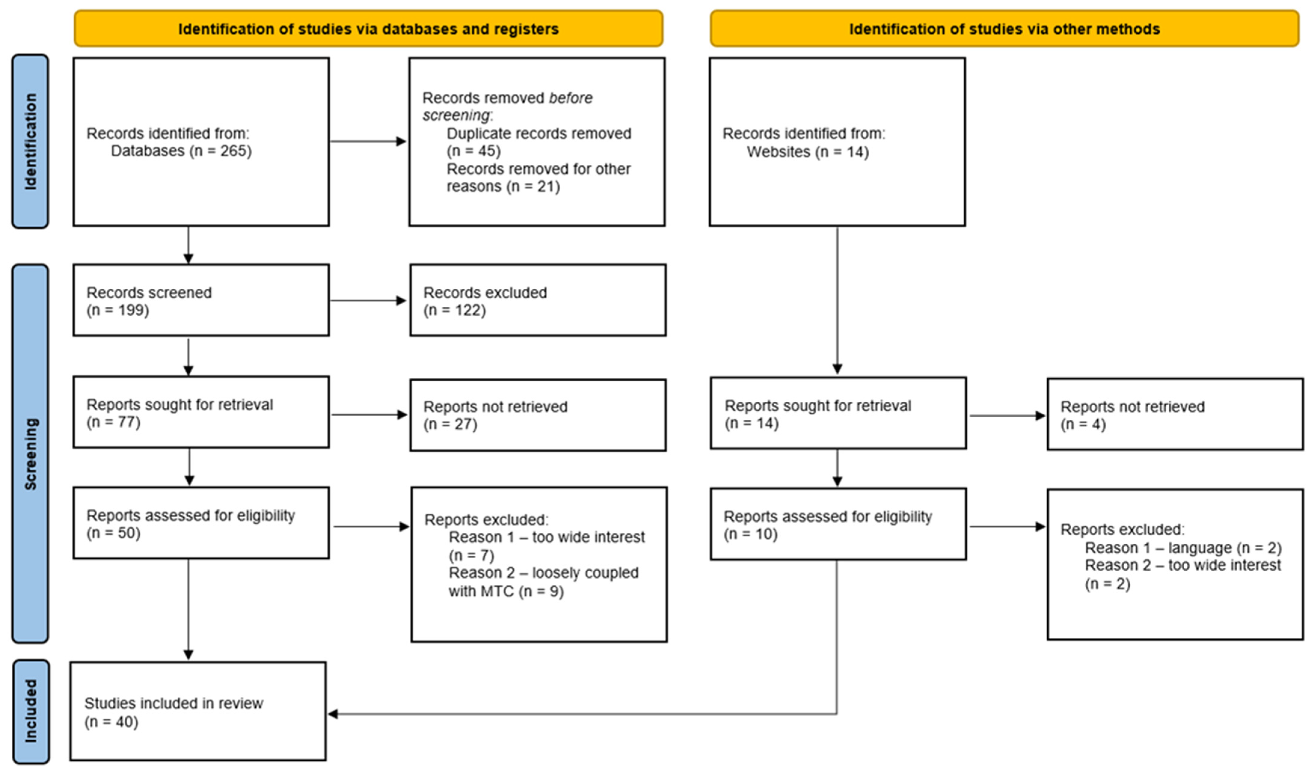
The PRISMA guidelines establish a structured framework for performing and presenting systematic literature reviews. It promotes clarity and reproducibility by directing researchers through a sequential procedure consisting of study identification, screening, eligibility assessment, and final inclusion. For the deeper insights into PRISMA guidelines and structure refer to the PRISMA checklist provided in the Supplementary Materials of this article. Figure 2 illustrates the literature retrieval workflow developed in accordance with PRISMA guidelines.
Better visualisation of the PRISMA workflow can be seen in Figure 2. The steps of the literature retrieval process, conducted in accordance with PRISMA guidelines, are outlined below:
  • Step 1: Identification of relevant scientific papers. The search process began with the selection of appropriate keywords to retrieve literature related to the term MTC from scientific databases. After defining the scope of the study, the keywords were identified with the help of VOSviewer as explained earlier. This initial search resulted in 265 identified records, as illustrated in Figure 2.
  • Step 2: Screening of identified records. The screening phase aimed to determine which studies were pertinent to the research while excluding those outside the primary focus. Titles, abstracts, and conclusions were reviewed, and the main text was briefly examined when necessary. Full-text evaluation was performed only for articles directly addressing MTC and maritime safety. Duplicate entries were removed, and some potentially relevant but inaccessible studies were excluded. Following this stage, 199 papers remained, corresponding to a retention rate of approximately 75%.
  • Step 3: Eligibility assessment. During this stage, the screened papers underwent detailed examination to determine their suitability for further analysis. Only the most significant contributions were retained to support a comprehensive understanding of the field and to provide sufficient material for bibliometric evaluation. These sources were various, including journal articles, conference papers, PhD dissertations, MSc theses, and other related scientific work that engage directly and substantively the concept of MTC. Works proposing or evaluating MTC frameworks, conducting comprehensive reviews of the concept of MTC, or presenting rigorous and in-depth investigations into related aspects of the topic. Brief concept papers or works addressing MTC only tangentially were excluded. This process reduced the dataset to 77 papers, representing a retention rate of about 39% from the screened records.
  • Step 4: Analysis of the included studies. The literature retrieval process concluded with the final selection of 40 papers for inclusion in the review. These studies were examined in full to capture their findings, insights, and implications, thereby establishing a robust foundation for the subsequent bibliometric analysis [25,26].
To conduct this comprehensive literature review, five scientific databases and academic web platforms were examined to locate relevant publications. Table 1 shows the databases and scholarly search engines included in the literature search process. It also presents the distribution of the retrieved papers across each source.
As expected, Web of Science and Scopus scientific databases were paramount to the dataset collection. As the most important scientific databases available to the general public, they served as a base for creating the dataset. Indicated in Table 1, most of the publications included in the literature review and bibliometric dataset—28 papers, representing approximately 70%—originated from the Web of Science (WoS) and Scopus scientific databases.
It is worth noting that even though Google Scholar and ResearchGate are not classified as traditional scientific databases or standard sources, they function as important academic search engines that index scholarly materials. For this reason, they were incorporated into the literature retrieval process, but only as a source for gathering unavailable literature. ResearchGate, in particular, offers a distinctive functionality through its researcher networking infrastructure, whereby access to restricted or paywalled publications can be requested directly from the authoring scholars. This feature proved valuable in retrieving a decent amount of full-text documents that would otherwise have remained inaccessible through standard institutional or open-access channels, thereby contributing to the comprehensiveness of the dataset assembled for this review.

2.2. Bibliometric Analysis Description

The construction of the dataset represents a crucial step prior to carrying out a comprehensive bibliometric analysis. In this study, the data consist of scientific articles, research papers, and other relevant publications related to MTC. The dataset used for this research includes 40 sources compiled in an Excel spreadsheet. This spreadsheet contains all publications associated with MTC, collision probability, and safety of navigation. The entries are arranged chronologically according to the year in which each paper was published. Table 2 illustrates the relationship between the column serial number and the information contained in each column. A more detailed explanation of the columns is provided below. Column 1—Paper ID: This column serves as an identification tool to assist in organizing and classifying the publications. Column 2—Title of paper: contains the exact title of each publication as recorded in the database. Column 3—Keywords: lists all keywords associated with the paper, regardless of how many are provided. Column 4—Authors: includes the names of all authors in the order in which they appear in the publication. Column 5—Number of authors: indicates the total number of authors for each paper, which in this dataset ranges from one to seven. Column 6—Type of paper: this column follows a predefined classification with two possible categories: “Journal article” and “Conference proceeding”. Column 7—Source of paper: identifies the source where the publication appeared. This may refer to the scientific journal that published the article or the conference proceedings in which it was included. Column 8—Year of publishing: indicates the official year in which the publication was released. Column 9—Country of origin: unlike other fields, this category requires additional clarification. The country classification was determined based on the institutional affiliation of all authors involved in the publication. For instance, if a paper has four authors from four different countries, each of those countries is credited in this column.
This type of data structuralization enables the basis for further analysis and assures the meeting of the PRISMA and SLR guidelines criteria. All data analysis and data visualization were carried out using Microsoft Excel (version 2019), a data manipulation, visualization, and reporting platform. This software gives a very detailed granulation of data and appropriately facilitates data visualization [27].

3. Results

This section gives a thorough look into the findings of the literature review, focusing on the main methodologies, research directions, and implications related to MTC. It comprises two parts. The first part represents a synthesis of the most relevant literature on MTC, in this case, a dataset. Major methodologies for modelling MTC are identified. The most common parameters for quantifying MTC are identified, as well as the tools used to measure it. Research directions are commented on. Papers are grouped by methodological approaches, i.e., collision probability and research directions (mostly connected to tools used to measure MTC, such as AIS). The second part presents a comprehensive bibliometric analysis identifying the most relevant data on publications themselves.

3.1. Main Methodologies, Research Directions, and Implications of MTC Models

Foundational studies in MTC primarily modeled traffic crowding and collision risk by quantifying spatial and motion characteristics of vessel interactions. For example, Wen et al. [28] introduced a marine traffic flow complexity model that incorporates relative distance, speed, and intersecting trajectory parameters to assess traffic situations and identify areas with elevated collision and crowding risk. This model demonstrates the spatial distribution of complexity using both simulated and real traffic data from high-density regions such as Shenzhen West Sea. These early models established a clear connection between traffic complexity, navigational risk, and situation awareness, highlighting that complexity is determined by spatiotemporal interaction patterns rather than vessel count alone. Contemporary maritime situational awareness depends extensively on AIS data, which supplies essential static and dynamic information for safety, security, and operational efficiency [10,11,29,30,31]. Nevertheless, as observed by Singh et al. and Kim et al., AIS data frequently contains noise, sensor errors, and irregular reporting intervals, which require rigorous preprocessing, cleaning, and interpolation to maintain temporal and geometric consistency for research applications [11,30].
Recent literature organizes maritime safety evaluation into three main areas: trajectory modeling, collision and grounding risk assessment, and traffic complexity analysis [7,10,32]. At the foundational level, Liu et al. [12] employ methods such as Soft Dynamic Time Warping (Soft-DTW) and Principal Component Analysis (PCA) to extract customary routes and centrelines, supporting route planning for both conventional vessels and Maritime Autonomous Surface Ships (MASS). Additionally, distribution-driven generation frameworks developed by Hwang et al. probabilistically resample empirical encounter data to generate realistic verification scenarios for collision avoidance algorithms [33].
Collision and grounding risk assessment has progressed from traditional point-wise metrics, such as Distance at Closest Point of Approach (DCPA) and Time to Closest Point of Approach (TCPA), to more sophisticated and dynamic formulations [7,31,34,35,36,37,38]. Recent studies by Xin et al. and Prabowo et al. integrate these parameters with the ship domain concept, including the Quaternion Ship Domain (QSD) [39] and Arena models, to evaluate spatial violations and the urgency of spatial occupancy. Building on these foundations, subsequent research has expanded in both methodological complexity and theoretical scope, incorporating complex network theory, statistical metrics, and machine learning techniques. An emerging trend involves representing maritime traffic as complex networks, where vessels are nodes and their interactions form network edges [8,40]. Zhang et al. developed a rule-based marine traffic situation complex network (R-MTSCN) that incorporates COLREGs-based collision avoidance relationships to construct directed networks. Topological indicators from these networks statistically characterize the evolution of traffic system complexity and enhance situational awareness for Vessel Traffic Service Operators (VTSOs) [41,42]. Node-importance evaluation methods further identify key vessels whose positions and movement patterns significantly influence overall traffic structure and complexity, thereby supporting intelligent supervision and prioritization in VTS operations [43]. Additionally, hybrid models that combine Monte Carlo simulations with deep learning, such as Bidirectional Long Short-Term Memory (Bi-LSTM) neural networks, are employed by Vukša et al. [44] and Liu et al. [45] to predict collision probabilities under varying maritime traffic densities [46]. To address inherent structural uncertainties, Park proposes frameworks that utilize Interval Type-2 Fuzzy Inference Systems in conjunction with Dempster–Shafer evidence theory for robust temporal risk fusion [31]. Tong et al. present a three-stage framework that integrates geographic priors with data-driven trajectory analysis to extract maritime traffic patterns from AIS data, thereby improving origin-destination recognition, anomaly removal, and the overall understanding of vessel behavior for more efficient and safer port operations [47].
Macro-level maritime traffic complexity (MTC) signifies a paradigm shift in safety analysis by emphasizing the “disorder” and “interaction density” of entire sea areas rather than focusing solely on individual vessel pairs [48,49,50]. A notable approach employs molecular dynamics theory, modeling ship traffic as a particle system and quantifying complexity through the radial distribution function (RDF) of speed, course, and position, as demonstrated by Liu et al. [51]. Other researchers, including Xin et al. [6,8], utilize complex network theory, applying graph indicators such as edge density, strength, and motif structures to elucidate the nested topological dependencies among multiple vessels. These complexity assessments are essential for identifying high-risk “hotspots” in inter-section waters or areas constrained by offshore wind farm (OWF) construction, which Liu et al. report as reducing navigable space and increasing encounter rates [49]. Son and Cho [52] evaluate ship-to-ship and ship–OWF collision probabilities to determine optimal maritime route widths, thereby supporting data-driven decisions for safe ship and OWF operations. Ji et al. incorporate the ship domain (SD) into the calculation of the proximity factor within the ship traffic complexity measurement model [53]. Feng et al. propose a multi-factor method for analyzing navigation complexity for unmanned ships in port areas, utilizing a coordination model and network framework; results indicate superior performance over single-factor approaches by more effectively identifying high-risk zones and enhancing safety prioritization [54]. Sun et al. employ a ship traffic conflict model that simultaneously considers the probability and potential consequences of ship collisions, effectively analyzing conflicts in high-risk waters using the Intuitionistic Fuzzy Multi-Attribute Boundary. Statistical and predictive analytics methods have been employed to quantify maritime traffic complexity across various scales. Zhang et al. introduced a technique combining the Lempel–Ziv entropy measure with the Technique for Order Preference by Similarity to an Ideal Solution (TOPSIS) to estimate traffic flow complexity from ship travel time sequences [55]. Findings from inland waterways indicate that high complexity is associated with irregular and unpredictable travel patterns, which correlate with increased accident incidence, thereby underscoring the relationship between complexity metrics and safety outcomes [56]. Furthermore, recent studies assessing traffic complexity in critical chokepoints such as the Malacca Strait utilize radial basis function regression and AIS-based dynamic parameters to quantify complexity variations across geographic traffic zones, illustrating the potential for scalable, data-driven complexity monitoring frameworks, data-driven complexity monitoring frameworks [51].
An additional research direction integrates hybrid indicators that combine behavioral dynamics with geometric traffic features. For instance, the Complexity-Aware Course–Speed (CS–TCI) model developed by Lee et al. incorporates AIS-derived changes in vessel speed and course into a traffic complexity index. This method effectively identifies complex maneuvering interactions and crossing hotspots that conventional spatial metrics may overlook, thereby providing deeper insights into navigational burden and maneuvering complexity relevant to operator decision-making and traffic management [57]. In parallel, other approaches utilize physics-inspired and data-driven models to capture the dynamic behavior of ship clusters. Liu et al. [58] proposed a dynamic MTC model based on radial distribution functions, with distinct sub-models for speed, course, and position, which are synthesized to map complexity across a given sea area. Validation using AIS data from the northern Yellow Sea demonstrated the model’s effectiveness in identifying high-complexity zones pertinent to real-time monitoring. Another study introduced an enhanced marine traffic complexity framework that combines Voronoi diagrams with complex networks to more accurately delineate “psychological space” and interaction strength among proximate vessels, thereby assisting navigators and Vessel Traffic Service Operators (VTSOs) in perceiving both local and global complexity in congested traffic environments, such as the Yangtze River [59].
Finally, the integration of these findings into Intelligent Transportation Systems involves centralized and decentralized Decision Support Systems (DSS) [6,10,60]. By formalizing multi-vessel encounters as non-zero-sum asymmetric polymatrix games, Grgičević et al. demonstrate how central coordinators can broadcast advised speed and heading changes to achieve a Nash equilibrium, thereby balancing individual operational efficiency with global safety. Additionally, Baldauf et al. [61] argue that simulation-based training that connects ship-handling and VTS is essential to prepare human operators and future autonomous systems for increasing inter-institutional coordination. Identifying key influential conflicts through network disintegration allows maritime supervisors to prioritize interventions that yield the maximum reduction in overall traffic complexity [7].
Across these diverse methodologies and approaches to MTC, two major implications emerge. First, MTC is fundamentally a multidimensional scientific construct that spans beyond just simple interaction geometry between the nodes (in this case, ships). Multiple factors, such as dynamic behavior, environmental conditions, and metadata (such as vessel type), generate a framework that must integrate multiple data types and analytical scales. Second, complexity measurement is operationally relevant: enhanced situational awareness, real-time traffic monitoring, and decision support for both human operators and automated systems are core motivations behind contemporary MTC models. Whether through complex networks, statistical entropy, or hybrid indicators, these studies collectively reinforce that MTC is not a static label but a dynamic system-level multidimensional measure shaped by multivariate interactions among vessels and their environment.
Table 3 represents a comprehensive comparison across all major contemporary MTC evaluation models available today. Each model is presented within eight dimensions: authorship and year, model name (and approach), key input parameters, study area, methodological framework, validation strategy, the inclusion of additional dimensions such as environmental, geospatial constraints, vessel speed, vessel heterogeneity, etc., and key limitations. The comparison reveals that all reviewed models rely exclusively on AIS-derived data, and none incorporates environmental variables such as wind, sea state, or visibility. Vessel heterogeneity is addressed only partially in a minority of models, typically limited to vessel size for ship domain scaling. These findings confirm a consistent methodological pattern across the literature and substantiate the conclusion that existing MTC frameworks remain geometrically constrained, reinforcing the need for a multidimensional evaluation approach.

3.2. Bibliometric Analysis

In Section 2.2, the bibliometric analysis structure was given in detail. The results are given below in this section.
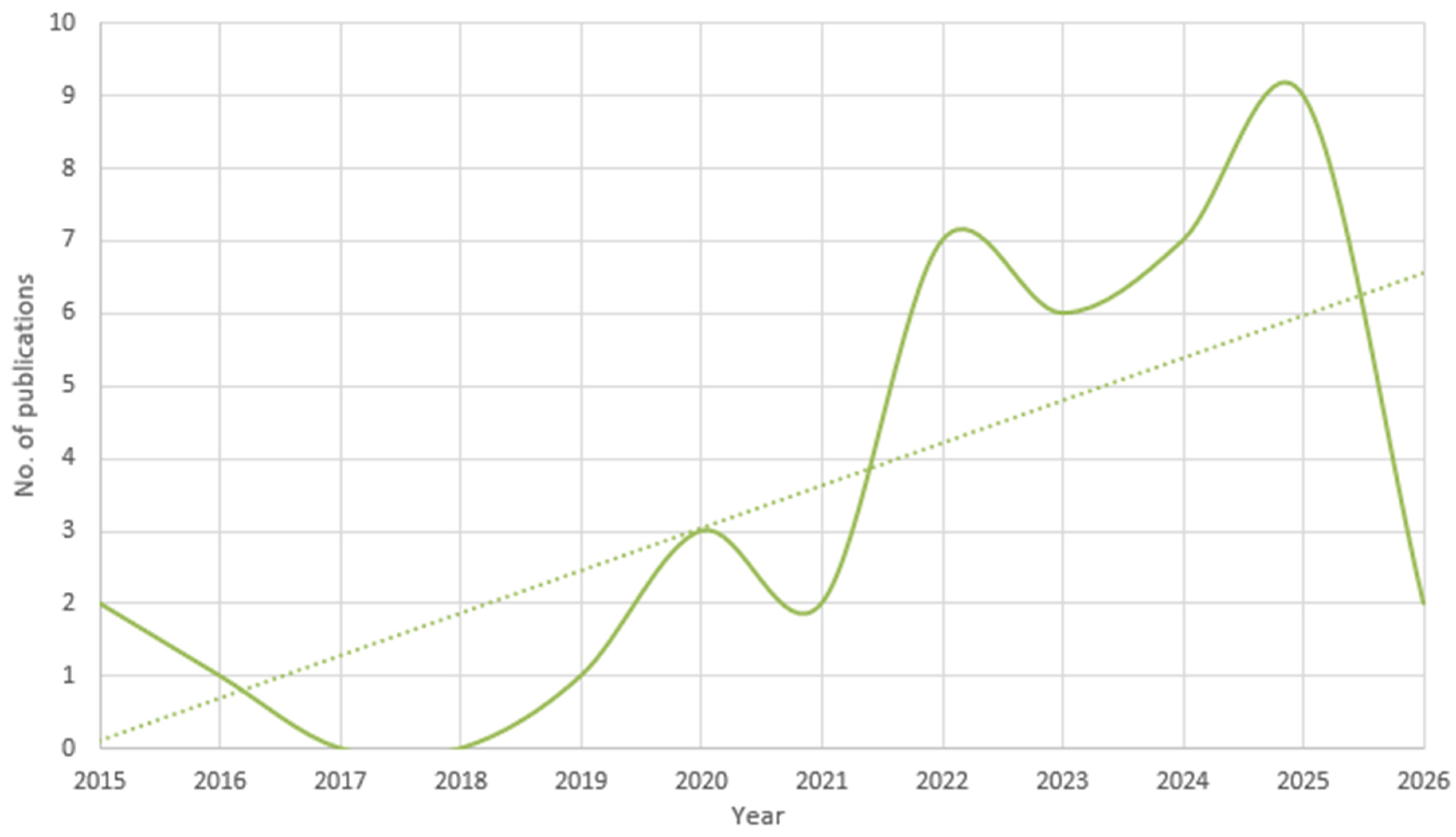
Figure 3 presents the distribution of the number of publications on MTC over the time period of 10 years. As mentioned before, 2015 was the year in which the term MTC was introduced in this sense that we know it today. Therefore, it was decided that the first year in this diagram is 2015.
Looking at Figure 3, it can easily be concluded that during the five-year period from 2021 through the end of 2025, a total of 30 scientific articles addressing MTC and navigation safety were identified. The highest levels of publication activity occurred in 2025. Overall, the trend suggests a gradual increase in scholarly attention to this subject over time. It should be noted that, due to the dataset being compiled in early 2026, the data for this year may not be fully representative of the entire year’s publications. Regarding the representativeness of the analyzed papers and data, an important limitation must be acknowledged. Because the total number of publications is relatively small, the results presented in this study are constrained by the dataset’s scope and may not fully reflect the broader body of research on MTC. Although efforts were made to ensure broad coverage, the dataset is inevitably shaped by the selection criteria and the availability of accessible sources. Consequently, the observed trends and resulting conclusions should be interpreted within these boundaries.
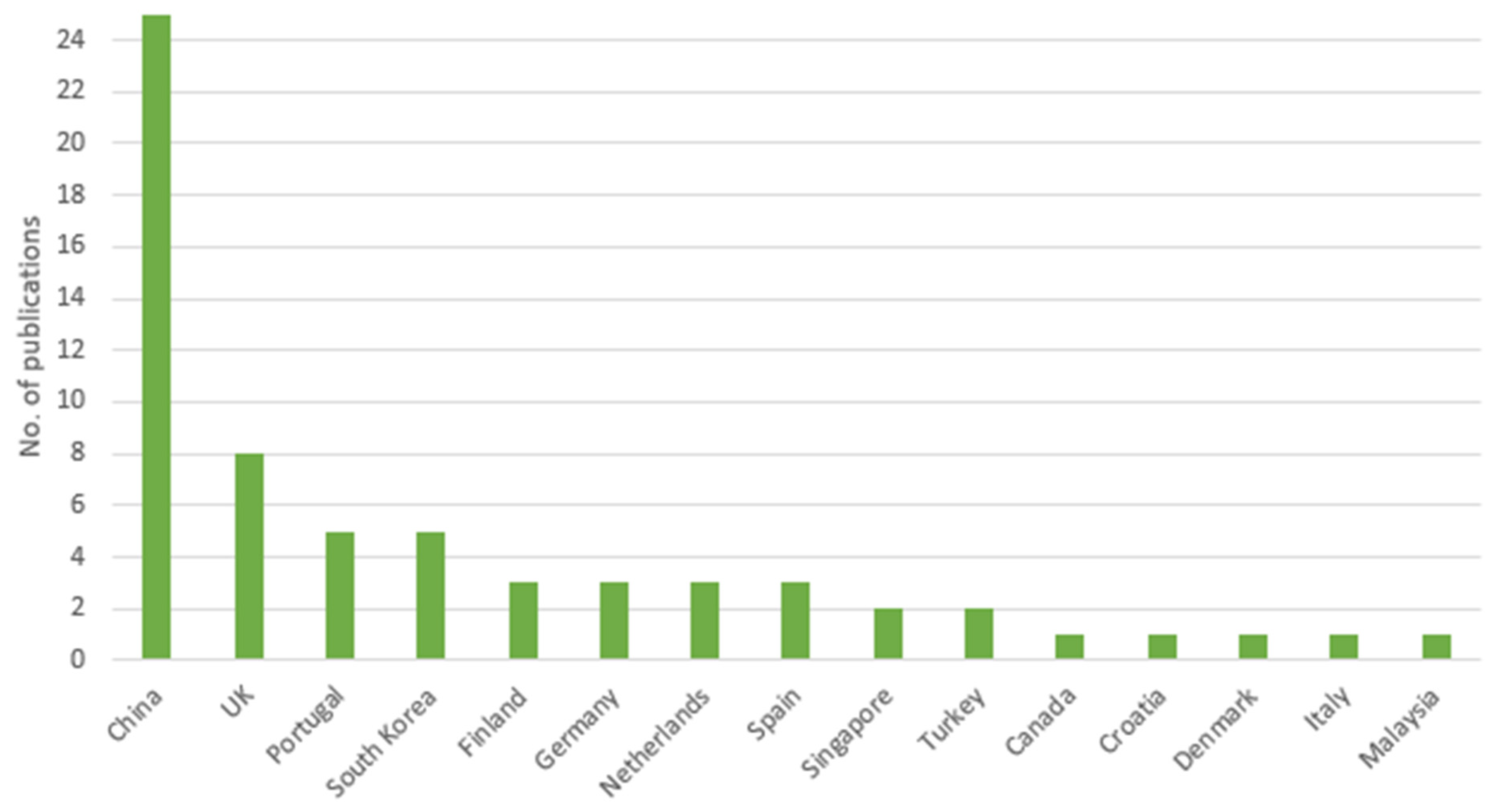
Figure 4 illustrates the distribution of scientific publications by country. As anticipated, China emerges as the leading contributor worldwide. Several factors explain this outcome: China has the largest population globally and a very large scientific community. In addition, the Chinese seas are among the most active and busiest maritime traffic areas in the world. European coastal states such as Portugal, Germany, and Spain have each contributed at least three papers. A significant share of the research output in this field also originates from Asian coastal nations, including South Korea, Singapore, and Malaysia. Meanwhile, several other European countries have each provided a single contribution. Additional countries that have participated in this area of research are also shown in Figure 4. Based on the distribution of publications by country, it can be inferred that in many nations engaged in maritime research, the subject of MTC and safety of navigation is currently regarded as both relevant and valuable.
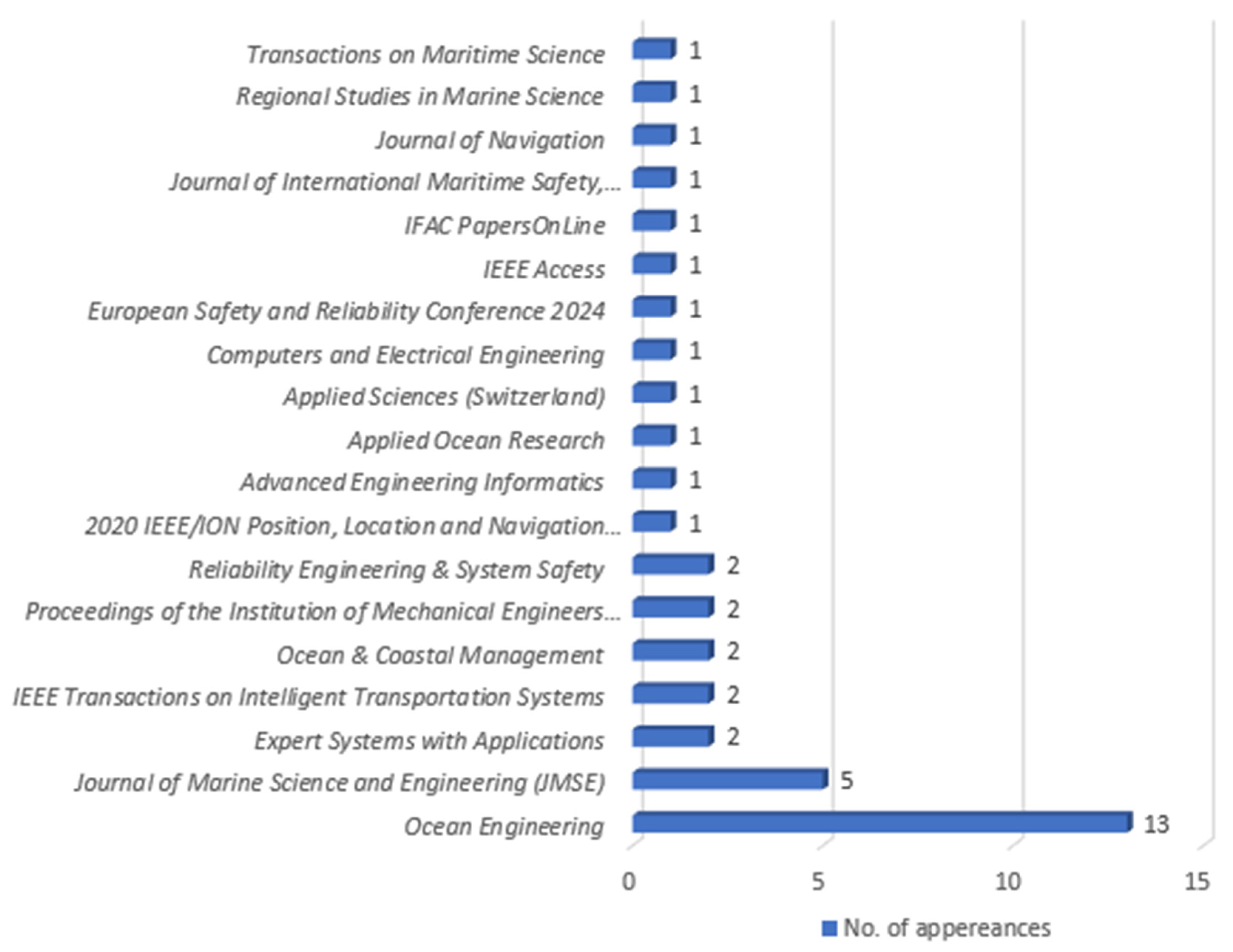
Figure 5 presents a visualization of the distribution of scientific publications across different source types. These sources include peer-reviewed journals, conference proceedings, and web platforms that regularly publish scientific research.
During the preparation of this literature review, the authors identified several journals that publish research related to MTC and navigation safety. The most prominent among them are Ocean Engineering, Journal of Marine Science and Engineering (JMSE), Expert Systems with Applications, Reliability Engineering and System Safety, Applied Ocean Research, and IEEE Access. Notably, the first two—Ocean Engineering and JMSE—account for 45% of the publications included in the dataset. According to the Journal Citation Reports (JCR) classification, both journals are ranked within the Q1 or Q2 quartiles, indicating a high level of scientific impact and quality. This suggests that these journals are primary publication venues for researchers working in this field and represent some of the most influential outlets for related studies. In addition to journal articles, more than four different international scientific conferences have contributed publications to the dataset, primarily focusing on maritime transportation safety, offshore mechanical engineering, and environmental sciences. Among these, the IEEE/ION Position, Location and Navigation Symposium (PLANS) stands out.
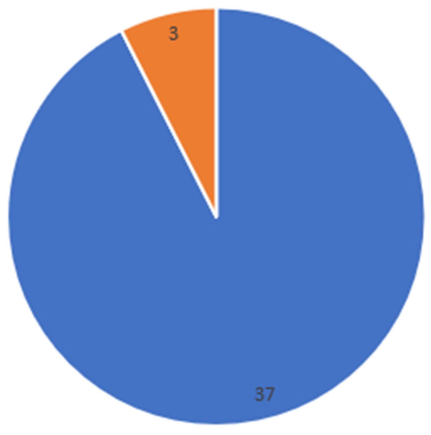
Figure 6 provides an overview of the different types of publications addressing MTC. The categories of papers included in the analysis consist of journal articles and conference papers (or conference proceedings) only.
Journal articles clearly dominate this classification, which contributes to the overall scientific credibility of the topic. Nearly 93% of the publications included in the dataset are journal articles. It is worth noting that the most comprehensive and influential research within a specific discipline is typically published in peer-reviewed journals. Conference papers also represent a minor share of the dataset, accounting for approximately 7% of the publications. Overall, the key foundational contributions in this research area tend to appear in leading scientific journals in the field.
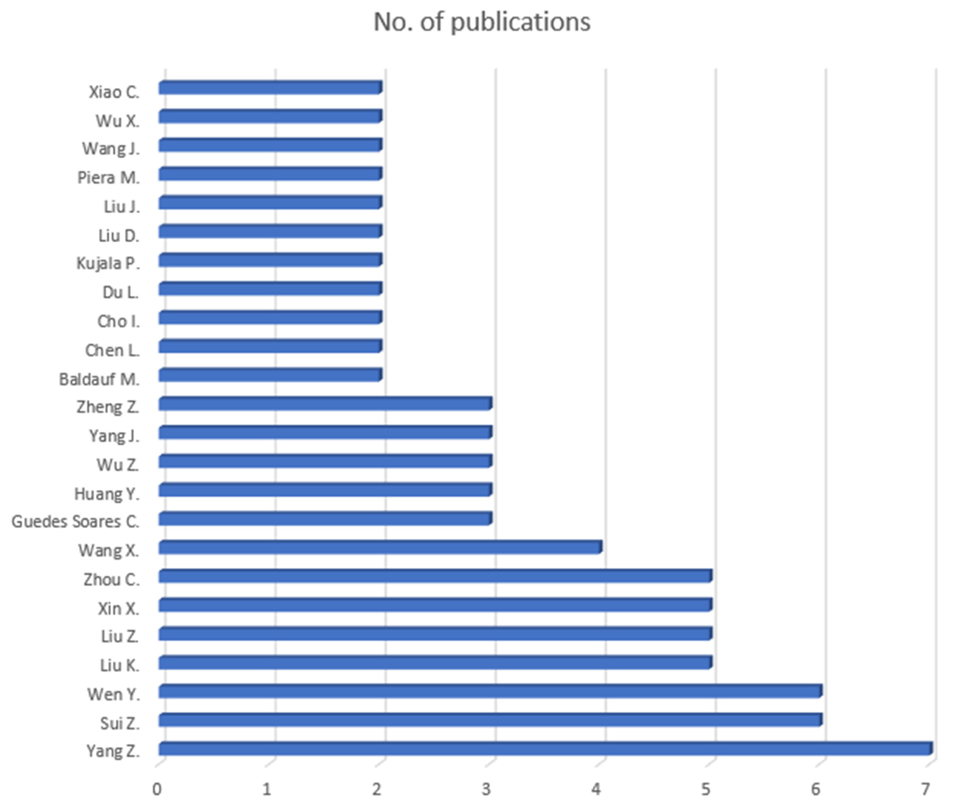
During the literature review process, the authors identified several key researchers working in the area of MTC and the implications of increased MTC to the safety of navigation. Figure 7 presents a bar chart showing the number of publications attributed to individual researchers who have contributed at least two works to the dataset. Among them, the most prominent and productive researcher is Z. Yang with seven publications. It is also evident that scientists Z. Sui, Y. Wen, K. Liu, and Z. Liu are significant contributors to this field, with more than five journal articles each. This type of authorship analysis can provide valuable insights for future studies in the field by highlighting leading researchers and potential sources of influential work. Additional high-contributing authors are displayed in Figure 7.
Identifying the leading contributors in a particular research field allows researchers to efficiently target relevant literature by using the “search by author name” function available in most scientific database search engines. This approach can significantly streamline the literature review process and reduce the time required to locate key publications. The same method was also applied during the preparation of this study.
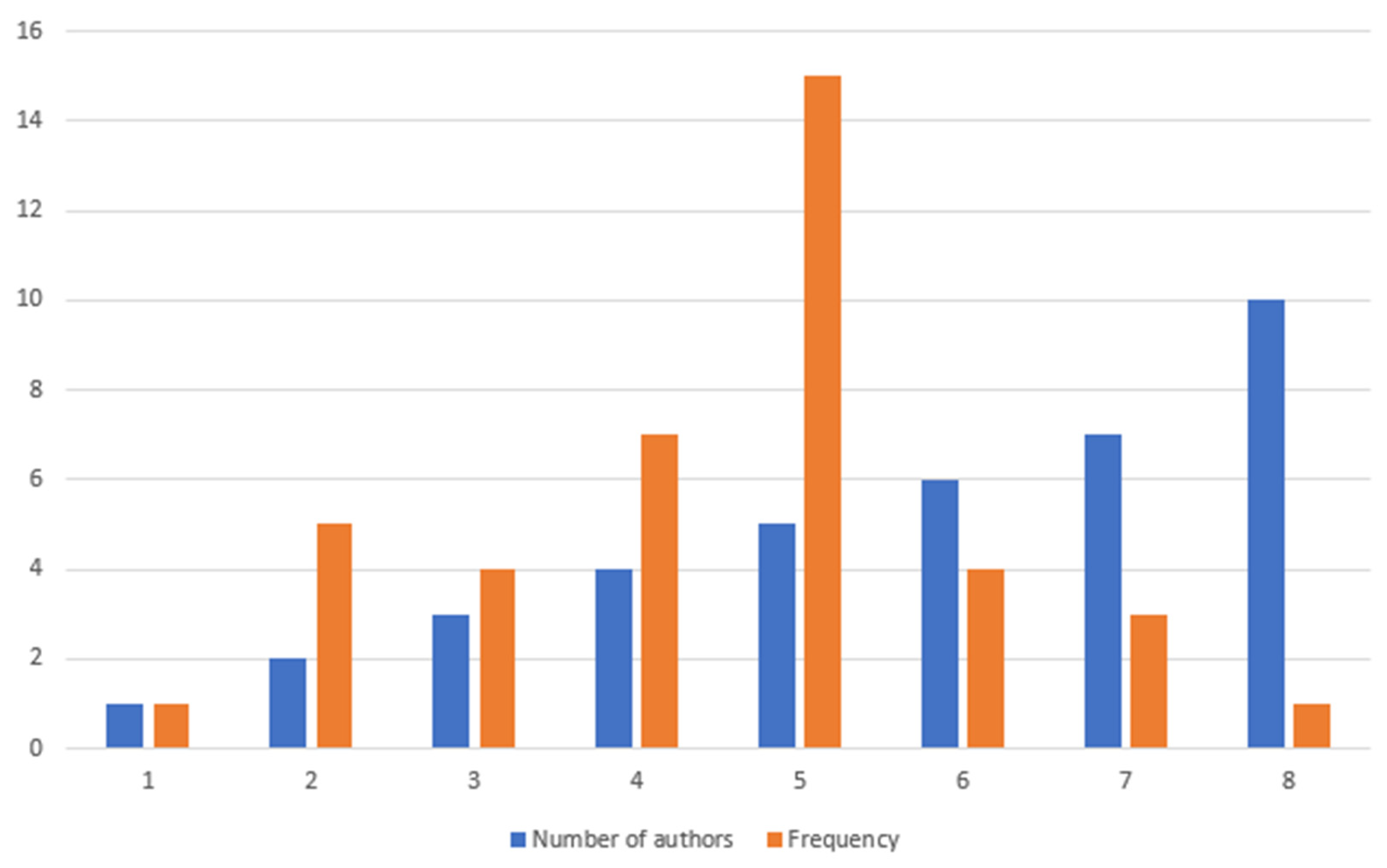
Figure 8 indicates that the majority of research related to MTC models is conducted collaboratively, typically involving two or more researchers. In the figure, the data is represented by a clustered column chart; the first column is the number of authors associated with a publication, while the second column illustrates how frequently that author count appears within the dataset. The results show that publications most commonly involve teams of four or five researchers. This pattern suggests that studies in this field are most often carried out by relatively small research groups.
Even though larger research groups (5+ authors) are uncommon in this field, there is still a decent percentage of those.
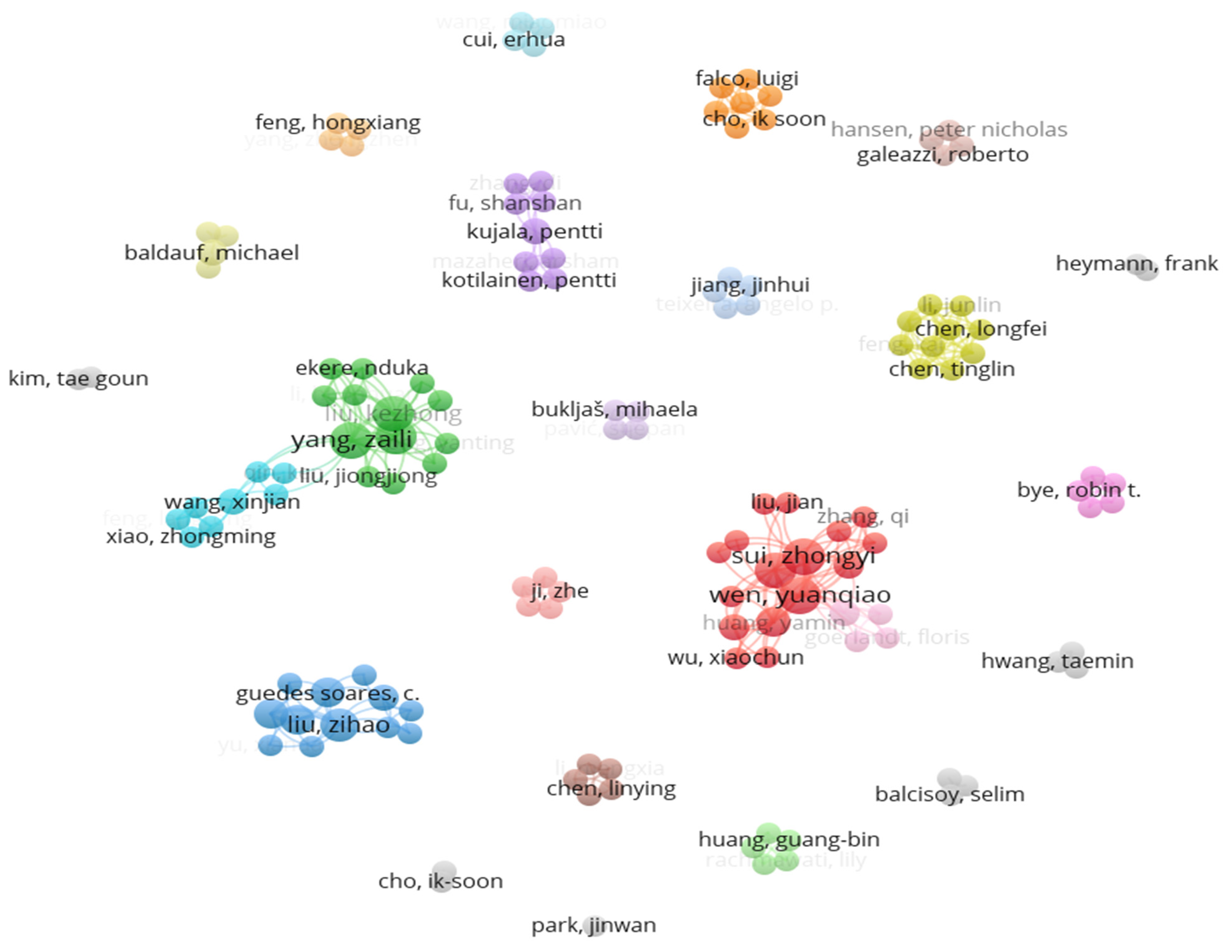
Finally, Figure 9 illustrates the clusters within the author collaboration network. This visualization was generated using VOSviewer, based on the literature dataset compiled in an Excel spreadsheet. The network consists of 22 distinct clusters, where nodes (dots) represent individual authors and the curved lines connecting them indicate co-authorship relationships. Different colors are used to visually separate the clusters, highlighting research groups with stronger internal collaboration. The visualization again confirms that Z. Sui and Y. Wen are among the leading researchers in this area, having formed a substantial collaboration network around themselves. In the chart, their prominence is reflected by the larger size of their nodes. Overall, this type of analysis provides valuable insight into collaboration patterns within the field and helps identify the most influential contributors in the scientific community.

4. Discussion

Having a thorough look into all the MTC frameworks from the dataset, it is more than evident that, in order to validate the model, researchers need AIS data analysis. In this sense, AIS data becomes inevitable for the proper validation and incidental mathematical modelling associated with any of the MTC frameworks/models. AIS data analysis is a paramount tool correlated with the modelling of MTC evaluation frameworks.
Table 4 represents the list of the most common parameters used to evaluate MTC across a wide range of frameworks grouped by parameter category. Also, it presents the description of the operational role of each parameter in MTC frameworks. Looking at Table 4, it can easily be concluded that all the parameters in all the MTC models reviewed use either AIS-ready or AIS-derived data for the complexity measurements. Therefore, it is easy to conclude that all the MTC models use only geometric and vessel motion-driven metrics instead of looking at the broader picture and having a holistic approach.
The systematic examination of the dataset reveals that, despite methodological diversification ranging from classical collision-probability formulations to complex network theory, entropy metrics, molecular-dynamics analogues, and machine learning architectures, the underlying parametric backbone of MTC models remains remarkably consistent. At the core of all frameworks lies the AIS data, which provides the fundamental spatiotemporal state variables required for modelling. Position, Speed over Ground (SOG), and Course over Ground (COG) form the irreducible kinematic triad upon which virtually every MTC formulation is constructed. From these primary variables, relative-motion descriptors such as inter-vessel distance, relative speed, convergence angle, DCPA, and TCPA are systematically derived. Whether embedded within probabilistic collision models, ship-domain violations, or rule-based network representations, these indicators quantify interaction geometry and temporal conflict evolution. Even macro-scale approaches such as RDF models or entropy-based traffic disorder estimations ultimately rely on aggregated expressions of these same relative-motion mechanics.
Traffic density and vessel count represent another universally recurring dimension. However, consistent with analytical systems framing, density alone is insufficient; it becomes operationally meaningful only when coupled with spatial distribution patterns, encounter frequency, and network edge density. Graph-theoretical MTC models formalize these interactions by mapping vessels as nodes and potential conflicts as edges, yet their adjacency structures are still constructed from AIS-derived proximity and motion parameters. Vessel heterogeneity, particularly type (available within the AIS messages) and size (LOA, GT), is likewise embedded across models to scale ship-domain dimensions, maneuvering constraints, and risk weighting functions. Temporal variability captured through AIS time-series analysis appears in entropy formulations, travel-time irregularity metrics, and predictive machine learning models, reinforcing that MTC is inherently dynamic rather than static.
In synthesis, AIS-driven spatiotemporal interaction geometry, enriched by vessel metadata and aggregated through statistical or network operators, constitutes the shared parametric denominator of all reviewed MTC models. This convergence confirms that, regardless of analytical paradigm, MTC measurement fundamentally reduces to structured interpretations of AIS-observed multi-vessel interaction dynamics.
Another concern regarding AIS overreliance is that it is susceptible to gaps arising from signal loss in congested or geographically constrained waters, transmission errors, and latency issues that compromise positional accuracy. More critically, AIS is vulnerable to intentional manipulation, including signal spoofing and identity falsification, which can introduce systematic distortions into complexity metrics derived from trajectory data. Additionally, vessels below the mandatory AIS carriage threshold, including many fishing vessels, small craft, and certain inland waterway operators, remain invisible to AIS-based frameworks entirely, introducing a structural blind spot that is particularly consequential in mixed-traffic environments. Future research should therefore prioritise the integration of multi-source data architectures that combine AIS with complementary inputs such as shore-based and vessel-mounted radar, satellite imagery, meteorological and oceanographic data, and vessel performance monitoring systems. Such sensor fusion approaches would not only compensate for the inherent limitations of any single data stream but would also enable the construction of genuinely more comprehensive MTC frameworks capable of capturing the environmental, behavioral, and operational dimensions of traffic complexity that AIS-only models systematically overlook.
Most contemporary frameworks for evaluating MTC rely predominantly on geometrical ship–ship interactions derived only from AIS data. In practice, these models assess complexity by analyzing parameters such as relative distance, course, CPA, and encounter geometry between vessels. While AIS-based geometric analysis provides valuable insight into traffic patterns, this approach represents a limited and overly simplified view of navigational complexity. Maritime environments are inherently multidimensional, and restricting MTC assessment solely to spatial interactions between vessels creates a clear methodological gap in current research. A comprehensive evaluation framework should also account for environmental conditions that significantly influence navigational risk, including wind intensity, sea state (wave conditions), and visibility. Furthermore, operational characteristics of vessels such as speed profiles and fleet heterogeneity (e.g., the coexistence of cargo ships, tankers, fishing vessels, and small craft) introduce additional layers of complexity within a maritime area. Another critical factor never considered in existing models is abnormal vessel behavior, such as engine failure or situations where a ship is not under command, forcing surrounding vessels to maneuver to avoid it. Such events can substantially alter local traffic dynamics and increase navigational difficulty. Consequently, future MTC models should adopt a multidimensional approach that integrates environmental, operational, and situational factors alongside traditional AIS-based geometric interactions.
While the classical approaches capture the spatial–temporal structure of traffic and the potential for navigational conflicts, they do not fully represent the operational complexity experienced in real maritime environments. A more comprehensive conceptualization of MTC should incorporate additional dimensions that influence navigational risk and decision-making. One such dimension is ship reliability, which reflects the probability of failures in critical onboard systems, including propulsion, steering, and navigation equipment. Variability in system reliability can significantly affect a vessel’s maneuverability and response capability, thereby altering the dynamics of traffic interactions [62,63,64,65]. Another essential dimension is the environmental context, including wind, waves, currents, and visibility conditions, all of which influence vessel motion and handling characteristics. Environmental forces may constrain maneuvering space, modify achievable speeds and turning behavior, and increase uncertainty in vessel trajectories [66,67]. Another potentially important dimension in the future could be situational awareness and level of fatigue for Officers of the Watch (OOW). There are research papers on the stress levels of seafarers and how this lack of situational awareness affects the decision-making process in ample time to avoid any situation that represents a risk to the safety of navigation. The health status of the seafarer affects the level of situational awareness needed for proper lookout by OOW. This potential dimension of MTC is rather unexplored [68,69].
Consequently, MTC cannot be fully captured through AIS-derived kinematic relationships alone. Integrating ship reliability and environmental factors into the MTC framework would enable a more realistic and operationally meaningful representation of maritime traffic systems, better reflecting the multifaceted conditions under which officers in charge of navigational watch and traffic management systems operate.

5. Conclusions

The concept of MTC has increasingly emerged as a prominent research focus within the field of ocean engineering, reflecting the growing operational, technological, and safety challenges associated with modern maritime transportation systems. Although maritime safety and traffic management have long been studied, the concept of MTC itself is relatively recent; the earliest identified publication explicitly addressing MTC appeared only in 2015. This relatively late emergence highlights both the novelty of the concept and the evolving nature of maritime operations, particularly in response to intensified shipping activities, the expansion of offshore infrastructure, and the integration of advanced navigational technologies. An examination of the publication timeline further highlights the rapid development of this research area, with nearly 90% of the analyzed studies published within the past five years. This fact strongly suggests not only growing academic interest but also an urgent practical need to better understand and quantify traffic complexity in increasingly congested maritime areas. The accelerating publication rate indicates an exponential growth trajectory, positioning MTC as a “hot topic” that is shaping contemporary research agendas in ocean engineering and maritime safety science. As scholars continue to refine analytical frameworks, modeling techniques, and risk assessment tools, the expanding body of literature signals a transition from conceptual exploration toward more systematic and application-oriented investigations.
Future research on MTC should include the introduction of the concept of MTC multidimensionality. This means that MTC evaluation frameworks should not only focus on geometrical parameters such as vessel movement variables and spatial organization but also extend the scope to other dimensions that inevitably affect MTC. The environmental component (i.e., wind force, speed, direction, sea current velocity, sea state, visibility, etc.) is one such dimension. Vessel heterogeneity index is another one. The speed of each vessel in the observed area is also crucial to adequate MTC evaluation. Even the detention history of a given vessel can be of importance to this “holistic” MTC evaluation framework. Vessel detention history, as recorded through Port State Control (PSC) inspections, represents a measurable proxy for a vessel’s operational reliability, maintenance standards, and overall management quality. Ships with recurring detentions are more likely to exhibit substandard equipment, reduced maneuverability, or non-compliant crew procedures. All of these parameters can potentially elevate navigational risk and contribute to unpredictable behavior within a traffic environment. Incorporating detention records into MTC frameworks would therefore add a vessel-level behavioral and compliance dimension that purely geometric or AIS-based metrics cannot capture.
Future research on MTC shall extend the scope of the existing concept of MTC to a broader, more comprehensive, and universal framework.
This study is subject to several limitations that should be recognized. The literature review, conducted using the PRISMA and SLR frameworks and supported by a comprehensive bibliometric analysis, effectively identifies prevailing research trends, commonly applied methodologies, and existing gaps in the literature. However, this approach does not allow for a detailed examination of specific technological innovations or the future research pathways required to address the growing interest in modelling MTC. Furthermore, certain important aspects related to theoretical foundations and practical operational challenges could not be examined in greater depth due to limitations in the available data. It should also be emphasized that this paper was designed as a review study rather than a conventional original research article introducing new methods or proposing novel research directions. Its primary objective was to synthesize, compare models, and consolidate the existing body of knowledge rather than to present new experimental results or original empirical findings. Further research on the concept of MTC should include a detailed examination of the accuracy of MTC models and real-world applicability. Consequently, these limitations indicate the need for further focused research efforts that could deliver more practical insights and support significant technological progress in this rapidly developing domain.

Supplementary Materials

The following supporting information can be downloaded at: https://www.mdpi.com/article/10.3390/technologies14040231/s1: PRISMA 2020 checklist.

Author Contributions

Conceptualization, V.M. and M.M.; methodology, V.M., T.S., B.L. and M.M.; software, V.M. and M.M.; validation, M.M. and B.L.; formal analysis, V.M. and B.L.; investigation, M.M.; resources, V.M.; data curation, B.L.; writing—original draft preparation, V.M.; writing—review and editing, T.S. and B.L.; visualization, V.M.; supervision, V.M., B.L., T.S. and M.M.; funding acquisition, T.S. and B.L. All authors have read and agreed to the published version of the manuscript.

Funding

This research received no external funding.

Data Availability Statement

No new data were created or analyzed in this study.

Conflicts of Interest

The authors declare no conflicts of interest.

Abbreviations

The following abbreviations are used in this manuscript:
AISAutomatic Identification System
Bi-LSTMBidirectional Long Short-Term Memory
COGCourse Over Ground
COLREGsInternational Regulations for Preventing Collisions at Sea
CS-TCIComplexity-Aware Course–Speed
DCPADistance at Closest Point of Approach
DSSDecision Support Systems
GTGross Tonnage
IF-MABACFuzzy Multi-Attribute Boundary Approximation Area Comparison
IMOInternational Maritime Organization
LOALength Over All
MASSMaritime Autonomous Surface Ships
MTCMaritime Traffic Complexity
OOWOfficer of the Watch
OWFOffshore Wind Farm
PCAPrincipal Component Analysis
PSCPort State Control
PhDDoctor of Philosophy
PRISMAPreferred Reporting Items for Systematic Reviews and Meta-Analyses
QSDQuaternion Ship Domain
R-MTSCNRule-based Marine Traffic Situation Complex Network
RDFRadial Distribution Function
SDShip Domain
SLRSystematic Literature Review
Soft-DTWSoft Dynamic Time Warping
SOGSpeed Over Ground
SOLASInternational Convention for the Safety of Life at Sea
TCPATime to Closest Point of Approach
TOPSISTechnique for Order Preference by Similarity to an Ideal Solution
TSSTraffic Separation Scheme
VTSVessel Traffic Service
VTSOsVessel Traffic Service Operators
WoSWeb of Science

References

  1. Helbing, D. Traffic and related self-driven many-particle systems. Rev. Mod. Phys. 2001, 73, 1067–1141. [Google Scholar] [CrossRef] [Scilit]
  2. Ducruet, C.; Notteboom, T. The worldwide maritime network of container shipping: Spatial structure and regional dynamics. Glob. Netw. 2012, 12, 395–423. [Google Scholar] [CrossRef] [Scilit]
  3. Kaluza, P.; Kölzsch, A.; Gastner, M.T.; Blasius, B. The complex network of global cargo ship movements. J. R. Soc. Interface 2010, 7, 1093–1103. [Google Scholar] [CrossRef] [Scilit] [PubMed]
  4. Laudeman, I.V.; Shelden, S.G.; Branstrom, R.; Brasil, C.L. Dynamic Density: An Air Traffic Management Metric; NASA: Washington, DC, USA, 1998. [Google Scholar]
  5. Histon, J.M. Mitigating Complexity in Air Traffic Control: The Role of Structure-Based Abstractions. Doctoral Thesis, Massachusetts Institute of Technology, Cambridge, MA, USA, 2008. [Google Scholar]
  6. Xin, X.; Liu, K.; Yang, Z. Maritime traffic complexity evaluation in complex waters. In Advances in Reliability, Safety and Security; Kolowrocki, Dabrowska, Eds.; Polish Safety and Reliability Association: Gdynia, Poland, 2024. [Google Scholar]
  7. Xin, X.; Liu, K.; Liu, J.; Wang, W.; Yang, Z. Modeling, evaluation, and mitigation of maritime traffic complexity in complex waters. IEEE Trans. Intell. Transp. Syst. 2025, 26, 13275–13292. [Google Scholar] [CrossRef] [Scilit]
  8. Xin, X.; Yang, Z.; Liu, K.; Zhang, J.; Wu, X. Multi-stage and multi-topology analysis of ship traffic complexity for probabilistic collision detection. Expert Syst. Appl. 2023, 213, 118890. [Google Scholar] [CrossRef] [Scilit]
  9. Xin, X.; Liu, K.; Loughney, S.; Wang, J.; Li, H.; Ekere, N.; Yang, Z. Multi-scale collision risk estimation for maritime traffic in complex port waters. Reliab. Eng. Syst. Saf. 2023, 240, 109554. [Google Scholar] [CrossRef] [Scilit]
  10. Tu, E.; Zhang, G.; Rachmawati, L.; Rajabally, E.; Huang, G.B. Exploiting AIS data for intelligent maritime navigation: A comprehensive survey. arXiv 2016, arXiv:1606.00981. [Google Scholar] [CrossRef] [Scilit]
  11. Singh, S.K.; Heymann, F. Machine learning-assisted anomaly detection in maritime navigation using AIS data. arXiv 2002, arXiv:2002.05013. [Google Scholar] [CrossRef] [Scilit]
  12. Liu, D.; Rong, H.; Guedes Soares, C. Shipping route modelling of AIS maritime traffic data at the approach to ports. Ocean Eng. 2023, 289, 115868. [Google Scholar] [CrossRef] [Scilit]
  13. Pallotta, G.; Vespe, M.; Bryan, K. Vessel pattern knowledge discovery from AIS data: A framework for anomaly detection and route prediction. Entropy 2013, 15, 2218–2245. [Google Scholar] [CrossRef] [Scilit]
  14. IMO. Resolution A.857(20)—Guidelines for Vessel Traffic Services; International Maritime Organization: London, UK, 1997. [Google Scholar]
  15. IMO. COLREG: Convention on the International Regulations for Preventing Collisions at Sea, Resolution A.1085(28); International Maritime Organization: London, UK, 2013. [Google Scholar]
  16. IMO. SOLAS: International Convention for the Safety of Life at Sea, 1974, as Amended—Consolidated Edition 2024; International Maritime Organization: London, UK, 2024. [Google Scholar]
  17. Bojić, F.; Gudelj, A.; Bošnjak, R. Port-related shipping gas emissions—A systematic review of research. Appl. Sci. 2022, 12, 3603. [Google Scholar] [CrossRef] [Scilit]
  18. Boko, Z.; Skoko, I.; Sanchez Varela, Z.; Milin, V. Advancing maritime safety: A literature review on machine learning and multi-criteria analysis in PSC inspections. J. Mar. Sci. Eng. 2025, 13, 974. [Google Scholar] [CrossRef] [Scilit]
  19. Glavinović, R.; Vukić, L.; Plazibat, V.; Račić, M. Methodological approaches to battery-powered ro-pax ferries in domestic shipping: A systematic review of route-based case studies. J. Mar. Sci. Eng. 2026, 14, 226. [Google Scholar] [CrossRef] [Scilit]
  20. Karin, I.; Medvešek, I.G.; Šoda, J. Best-suited communication technology for maritime signaling facilities: A literature review. Appl. Sci. 2025, 15, 3452. [Google Scholar] [CrossRef] [Scilit]
  21. Maljković, M.; Pavić, I.; Meštrović, T.; Perkovič, M. Ship maneuvering in shallow and narrow waters: Predictive methods and model development review. J. Mar. Sci. Eng. 2024, 12, 1450. [Google Scholar] [CrossRef] [Scilit]
  22. Meštrović, T.; Pavić, I.; Maljković, M.; Androjna, A. Challenges for the education and training of seafarers in the context of Autonomous shipping: Bibliometric analysis and systematic literature review. Appl. Sci. 2024, 14, 3173. [Google Scholar] [CrossRef] [Scilit]
  23. Milin, V.; Skoko, I.; Lekšić, Ž.; Boko, Z. Navigational safety hazards posed by offshore wind farms: A comprehensive literature review and bibliometric analysis. J. Mar. Sci. Eng. 2025, 13, 1330. [Google Scholar] [CrossRef] [Scilit]
  24. PRISMA. PRISMA [Internet]. 2025 [Cited 2026 February 2]. PRISMA Flow Diagram. Available online: https://www.prisma-statement.org/prisma-2020-flow-diagram (accessed on 25 January 2026).
  25. Page, M.J.; McKenzie, J.E.; Bossuyt, P.M.; Boutron, I.; Hoffmann, T.C.; Mulrow, C.D.; Shamseer, L.; Tetzlaff, J.M.; Akl, E.A.; Brennan, S.E.; et al. The PRISMA 2020 statement: An updated guideline for reporting systematic reviews. BMJ 2021, 372, n71. [Google Scholar] [CrossRef] [Scilit] [PubMed]
  26. Page, M.J.; Moher, D.; Bossuyt, P.M.; Boutron, I.; Hoffmann, T.C.; Mulrow, C.D.; Shamseer, L.; Tetzlaff, J.M.; Akl, E.A.; Brennan, S.E.; et al. PRISMA 2020 explanation and elaboration: Updated guidance and exemplars for reporting systematic reviews. BMJ 2021, 372, n160. [Google Scholar] [CrossRef] [PubMed]
  27. Microsoft Corporation. Microsoft Excel 2016; Microsoft Corporation: Redmond, WA, USA, 2016. [Google Scholar]
  28. Wen, Y.; Huang, Y.; Zhou, C.; Yang, J.; Xiao, C.; Wu, X. Modelling of marine traffic flow complexity. Ocean Eng. 2015, 104, 500–510. [Google Scholar] [CrossRef] [Scilit]
  29. Mazaheri, A.; Montewka, J.; Kotilainen, P.; Sormunen, O.V.E.; Kujala, P. Assessing grounding frequency using ship traffic and waterway complexity. J. Navig. 2015, 68, 89–106. [Google Scholar] [CrossRef] [Scilit]
  30. Kim, Y.-J.; Lee, J.-S.; Pititto, A.; Falco, L.; Lee, M.-S.; Yoon, K.-K.; Cho, I.-S. Maritime traffic evaluation using spatial-temporal density analysis based on big AIS data. Appl. Sci. 2022, 12, 11246. [Google Scholar] [CrossRef] [Scilit]
  31. Park, J. Estimation of vessel collision risk under uncertainty using interval type-2 fuzzy inference systems and dempster–shafer evidence theory. J. Mar. Sci. Eng. 2025, 14, 34. [Google Scholar] [CrossRef] [Scilit]
  32. Wu, B.; Xu, X.; Teixeira, Â.P.; Yan, X.; Jiang, J. An inland waterway traffic complexity evaluation method using radar sequential images. Ocean Eng. 2025, 315, 119842. [Google Scholar] [CrossRef] [Scilit]
  33. Hwang, T.; Hwang, T.; Youn, I.H. Distribution-driven generation model of collision risk scenarios for MASS collision avoidance system verification. J. Int. Marit. Saf. Environ. Aff. Shipp. 2026, 10, 2613467. [Google Scholar] [CrossRef] [Scilit]
  34. Yoo, Y.; Kim, T.G. An improved ship collision risk evaluation method for Korea Maritime Safety Audit considering traffic flow characteristics. J. Mar. Sci. Eng. 2019, 7, 448. [Google Scholar] [CrossRef] [Scilit]
  35. van Westrenen, F.; Baldauf, M. Improving conflicts detection in maritime traffic: Case studies on the effect of traffic complexity on ship collisions. Proc. Inst. Mech. Eng. Part M J. Eng. Marit. Environ. 2020, 234, 209–222. [Google Scholar] [CrossRef] [Scilit]
  36. Öztürk, Ü.; Boz, H.A.; Balcisoy, S. Visual analytic based ship collision probability modeling for ship navigation safety. Expert Syst. Appl. 2021, 175, 114755. [Google Scholar] [CrossRef] [Scilit]
  37. Feng, H.; Grifoll, M.; Yang, Z.; Zheng, P. Collision risk assessment for ships’ routeing waters: An information entropy approach with Automatic Identification System (AIS) data. Ocean Coast. Manag. 2022, 224, 106184. [Google Scholar] [CrossRef] [Scilit]
  38. Li, M.; Mou, J.; Chen, P.; Chen, L.; van Gelder, P.H.A.J.M. Real-time collision risk based safety management for vessel traffic in busy ports and waterways. Ocean Coast. Manag. 2023, 234, 106471. [Google Scholar] [CrossRef] [Scilit]
  39. Prabowo, Y.A.; Hansen, P.N.; Papageorgiou, D.; Galeazzi, R. Codification of good seamanship in complex and congested waterways. arXiv 2024, arXiv:2407.09223. [Google Scholar] [CrossRef] [Scilit]
  40. Xiao, Z.; Sun, Q.; Feng, L.; Wang, X.; Lu, X. A novel method for complexity analysis of marine traffic based on complex networks. Proc. Inst. Mech. Eng. Part M J. Eng. Marit. Environ. 2025, 239, 899–923. [Google Scholar] [CrossRef] [Scilit]
  41. Zhang, F.; Liu, Y.; Du, L.; Goerlandt, F.; Sui, Z.; Wen, Y. A rule-based maritime traffic situation complex network approach for enhancing situation awareness of vessel traffic service operators. Ocean Eng. 2023, 284, 115203. [Google Scholar] [CrossRef] [Scilit]
  42. Sui, Z.; Wen, Y.; Huang, Y.; Zhou, C.; Xiao, C.; Chen, H. Empirical analysis of complex network for marine traffic situation. Ocean Eng. 2020, 214, 107848. [Google Scholar] [CrossRef] [Scilit]
  43. Sui, Z.; Wen, Y.; Huang, Y.; Zhou, C.; Du, L.; Piera, M.A. Node importance evaluation in marine traffic situation complex network for intelligent maritime supervision. Ocean Eng. 2022, 247, 110742. [Google Scholar] [CrossRef] [Scilit]
  44. Vukša, S.; Vidan, P.; Bukljaš, M.; Pavić, S. Research on ship collision probability model based on monte carlo simulation and bi-LSTM. J. Mar. Sci. Eng. 2022, 10, 1124. [Google Scholar] [CrossRef] [Scilit]
  45. Liu, Z.; Zhou, D.; Zheng, Z.; Wu, Z.; Guedes Soares, C. A multi-dimensional formulation for assessing regional collision risk based on AIS data. Appl. Ocean. Res. 2025, 161, 104612. [Google Scholar] [CrossRef] [Scilit]
  46. Wang, M.; Wang, Y.; Cui, E.; Fu, X. A novel multi-ship collision probability estimation method considering data-driven quantification of trajectory uncertainty. Ocean Eng. 2023, 272, 113825. [Google Scholar] [CrossRef] [Scilit]
  47. Tong, Y.; Liu, K.; Yu, Y.; Xin, X.; Yang, Z. Integrating geographic priors and automatic identification system data mining for maritime traffic pattern extraction in complex port waters. Adv. Eng. Inform. 2026, 69, 104000. [Google Scholar] [CrossRef] [Scilit]
  48. Liu, Z.; Wu, Z.; Zheng, Z.; Yu, X. A molecular dynamics approach to identify the marine traffic complexity in a waterway. J. Mar. Sci. Eng. 2022, 10, 1678. [Google Scholar] [CrossRef] [Scilit]
  49. Liu, J.; Yu, W.; Sui, Z.; Zhou, C. The impact of offshore wind farm construction on maritime traffic complexity: An empirical analysis of the Yangtze River Estuary. J. Mar. Sci. Eng. 2024, 12, 2232. [Google Scholar] [CrossRef] [Scilit]
  50. Cheng, X.; Sui, Z.; Wen, Y.; Han, D. An improved maritime traffic situation complexity model for intelligent maritime management in the inland ferry area. Comput. Electr. Eng. 2024, 119, 109612. [Google Scholar] [CrossRef] [Scilit]
  51. Liu, D.; Liu, Z.; Kang, H.S.; Siow, C.L.; Soares, C.G. Traffic complexity assessment on the malacca strait with traffic zone matrix based on AIS data. Ocean Eng. 2024, 314, 119687. [Google Scholar] [CrossRef] [Scilit]
  52. Son, W.J.; Cho, I.S. Optimal maritime traffic width for passing offshore wind farms based on ship collision probability. Ocean Eng. 2024, 313, 119498. [Google Scholar] [CrossRef] [Scilit]
  53. Ji, Z.; Zhang, Y.; Wang, F.; Yang, J.; Zou, Y. Identification of multi-ship maritime traffic situation based on ship traffic complexity measurement model. Ocean Eng. 2024, 301, 117442. [Google Scholar] [CrossRef] [Scilit]
  54. Feng, K.; Li, J.; Chen, T.; Wang, X.; Wang, J.; Chen, L.; Wang, Q.; Shen, C.; Li, Y.; Jiang, Y. Complexity analysis of navigation situation of intelligent ships in port area with multi-factor coupling. Reg. Stud. Mar. Sci. 2025, 91, 104503. [Google Scholar] [CrossRef] [Scilit]
  55. Sun, Y.; Yang, J.; Wang, X.; Qin, K.; Yang, Z. Integrating ship traffic conflicts into navigation risk modelling for safety at traffic-intensive waters. Ocean Eng. 2025, 341, 122570. [Google Scholar] [CrossRef] [Scilit]
  56. Zhang, M.; Zhang, D.; Fu, S.; Kujala, P.; Hirdaris, S. A predictive analytics method for maritime traffic flow complexity estimation in inland waterways. Reliab. Eng. Syst. Saf. 2022, 220, 108317. [Google Scholar] [CrossRef] [Scilit]
  57. Lee, E.J.; Kim, H.S.; Yu, Y. A complexity-aware course–speed model integrating traffic complexity index for nonlinear crossing waters. J. Mar. Sci. Eng. 2025, 13, 2086. [Google Scholar] [CrossRef] [Scilit]
  58. Liu, Z.; Wu, Z.; Zheng, Z.; Wang, X.; Guedes Soares, C. Modelling dynamic maritime traffic complexity with radial distribution functions. Ocean Eng. 2021, 241, 109990. [Google Scholar] [CrossRef] [Scilit]
  59. Sui, Z.; Wen, Y.; Zhou, C.; Huang, X.; Zhang, Q.; Liu, Z.; Piera, M.A. An improved approach for assessing marine traffic complexity based on Voronoi diagram and complex network. Ocean Eng. 2022, 266, 112884. [Google Scholar] [CrossRef] [Scilit]
  60. Grgičević, L.; Coates, E.M.; Fossen, T.I.; Bye, R.T.; Osen, O.L. Centralised decision support in maritime vessel traffic services: A polymatrix game solution. IEEE Access 2025, 13, 74375–74395. [Google Scholar] [CrossRef] [Scilit]
  61. Baldauf, M.; Besikci, E.B.; Shi, X. Simulating growing complexity in maritime traffic. Trans. Marit. Sci. 2025, 14, 1–11. [Google Scholar] [CrossRef] [Scilit]
  62. Bilobrk, M.; Perić, T.; Stazić, L.; Lalić, B. Analysis of complex reliability, case study. Transp. Res. Procedia 2025, 83, 390–399. [Google Scholar] [CrossRef] [Scilit]
  63. Stanivuk, T.; Dašić, P.; Karić, M.; Žanić Mikuličić, J. Reliability of the ship systems. In Proceedings of the 17th International Conference “Research and Development in Mechanical Industry” RaDMI-2017; SaTCIP Publisher Ltd.: Zlatibor, Serbia; Vrnjačka Banja, Serbia, 2017; pp. 295–302. [Google Scholar]
  64. Vidan, P.; Stanivuk, T.; Bielić, T. Effectiveness and ergonomic of integrated navigation system. Trans. Marit. Sci. 2012, 1, 17–21. [Google Scholar] [CrossRef] [Scilit]
  65. Kasum, J.; Ivančić, P.; Stanivuk, T. Maritime accidents and activities of international community. In GIS Odyssey 2010 Proceedings: Space, Heritage & Future; Kerekovic, D., Ed.; HIZ GIS Forum: Zagreb, Croatia; University of Silesia: Katowice, Poland, 2010; pp. 63–68. [Google Scholar]
  66. Milin, V.; Stanivuk, T.; Skoko, I.; Bulić, T. Dijkstra and A* algorithms for algorithmic optimization of maritime routes and logistics of offshore wind farms. J. Mar. Sci. Eng. 2025, 13, 1863. [Google Scholar] [CrossRef] [Scilit]
  67. Popović, R.; Kulović, M.; Stanivuk, T. Meteorological safety of entering Eastern Adriatic ports. Trans. Marit. Sci. 2014, 3, 53–60. [Google Scholar] [CrossRef] [Scilit]
  68. Russo, A.; Mulić, R.; Kolčić, I.; Maleš, M.; Jerončić Tomić, I.; Pezelj, L. Longitudinal study on the effect of onboard service on Seafarers’ health statuses. Int. J. Environ. Res. Public Health 2023, 20, 4497. [Google Scholar] [CrossRef] [Scilit]
  69. Pezelj, L.; Maleš, M.; Milavić, B. Stressfulness assessment of the skippers—A pilot study. In IMLA30 Book of Proceedings; Peronja, I., Vukić, L., Mandić, N., Eds.; University of Split—Faculty of Maritime Studies: Split, Crotia, 2025; pp. 546–557. [Google Scholar]
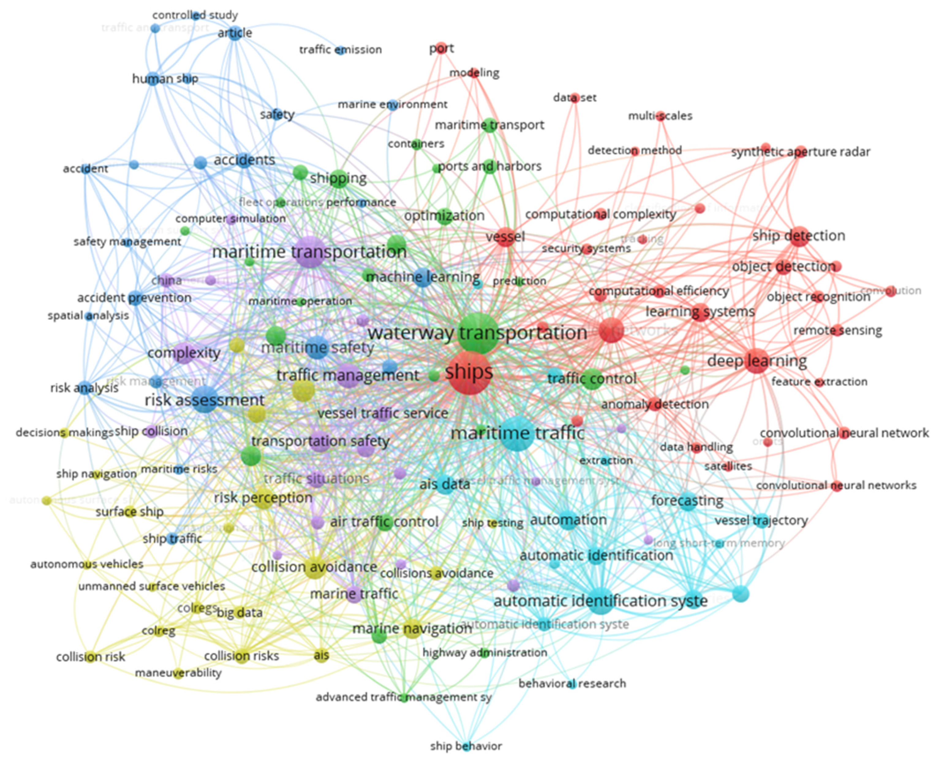
Figure 1. The most common keywords connected to the term MTC (Scopus database).
Technologies 14 00231 g001
Figure 2. Literature retrieval process flowchart using PRISMA 2020 guidelines [24,25,26].
Technologies 14 00231 g002
Figure 3. Annual publication number over the last 10 years.
Technologies 14 00231 g003
Figure 4. Distribution of publications per country.
Technologies 14 00231 g004
Figure 5. Distribution of publications per source.
Technologies 14 00231 g005
Figure 6. Distribution of publications per type (of paper).
Technologies 14 00231 g006
Figure 7. Distribution of authors with two or more publications on the topic of MTC.
Technologies 14 00231 g007
Figure 8. Distribution of the number of authors per single publication.
Technologies 14 00231 g008
Figure 9. Cluster visualization of author collaboration networks.
Technologies 14 00231 g009
Table 1. Distribution of scientific papers identified and included per database in the literature retrieval process.
Scientific DatabaseNumber of
Identified Papers
Number of
Selected Papers
Web of Science8215
Scopus7813
ScienceDirect10512
Total26540
Table 2. Overview of the Excel table structure.
Serial Number of a ColumnItem
1.Paper ID
2.Title of paper
3.Keywords
4.Authors
5.Number of authors
6.Type of paper
7.Source of paper
8.Year of publishing
9.Country of origin
Table 3. Comparison between different MTC models across the reviewed literature.
Author(s) and YearModel NameKey Input ParametersStudy AreaMethodological
Framework
ValidationAdditional DimensionsKey Limitation(s)
Wen et al. 2015Marine Traffic Flow Complexity ModelTraffic density, inter-vessel
distance, relative speed,
convergence angle,
trajectory intersection
Shenzhen West Sea (China)Density factor + conflict factor; spatial interpolation for area complexitySimulated and real AIS data
comparison
PartialDoes not capture multi-vessel
interaction topology; limited to
geometric pairwise metrics
Sui et al. 2020Marine Traffic
Situation Complex Network (MTSCN)
Position, approaching rate, COG, SOG, inter-vessel
distance
Yangtze River
Estuary (China)
Proximity-based edges: vertex strength, clustering coefficient, network entropyAIS data;
topological
pattern analysis
NoIgnores asymmetry of
navigational influence; no
environmental or
behavioral dimensions
Sui et al. 2022Improved MTSCN with Voronoi
Diagram
Position, SOG, COG,
Voronoi cell geometry,
approaching rate
Yangtze River (China)Voronoi diagram defines
“psychological space” +
improved MTSCN for global and local complexity
Simulated
ship-crossing
scenarios, AIS data
NoVoronoi-based neighbors may not reflect navigational priority rules fully
Liu et al. 2021Dynamic MTC Model with
Radial
Distribution
Functions (RDF)
Position, SOG, COG,
inter-vessel speed,
and course
differences
Northern Yellow Sea (China)Three sub-models (speed, course, position RDF);
synthesized to map complexity across sea area
AIS data, spatial complexity mapping
validated
qualitatively
NoPhysics-based analogy limits
behavioral realism; no
environmental or vessel-type
integration
Liu et al. 2022Molecular
Dynamics Approach for Marine Traffic Complexity
Position, SOG, COG, velocity plane distance (speed/course combined)Waterway off China coastParticle-system analogy; radial distribution function applied to velocity and position planes separatelyAIS data case study: qualitative validation against traffic scenariosNoSimplified physical analogy;
ignores human decision-making, COLREGs, and environmental conditions
Zhang et al. 2022Predictive
Analytics for
Traffic Flow
Complexity
(LZ-TOPSIS)
Ship travel time sequences, AIS trajectory data, geographic
location, time intervals
Yangtze River (China)
-inland
waterway
Lempel–Ziv entropy
(irregularity/unpredictability of travel time) + TOPSIS
ranking of complexity levels
Four sequence
types, correlation with accident
records
NoMicroscopic perspective only; travel-time proxy may not
capture spatial interaction structure
Zhang et al. 2023Rule-Based Maritime Traffic Situation Complex Network (R-MTSCN)Position, COG, SOG, COLREGs encounter geometryYangtze River
Estuary (China)
Directed weighted network; COLREGs-based edges; degree, vertex strength, and strength distribution as
complexity indicators
AIS data,
comparison with
undirected MTSCN
NoCOLREGs compliance
assumed; non-SOLAS vessels excluded
Xin et al. 2022Multi-Stage
Multi-Topology Ship Traffic
Complexity
Position, DCPA, TCPA, SOG, COG, conflict criticality index (FCI), traffic complexity matrixComplex port
waters (China)
Three-stage framework:
conflict detection → complexity matrix → topological analysis; FCI-based conflict criticality
Scenario analysis + AIS data validation; comparison with single-topology
Methods
PartialFCI calibration may vary by
waterway type
Ji et al. 2024Ship Traffic
Complexity
Measurement Model with Ship Domain
Ship Domain (SD) geometry, proximity factor, DCPA, TCPA, SOG, COGHigh
Traffic
waters (China)
Ship domain integrated into proximity factor calculation within traffic complexity
measurement model
Multi-ship encounter simulation + AIS dataPartialShip domain model selection is subjective
Cheng et al. 2024Improved Maritime Traffic Situation Complexity Model for Ferry AreasPosition, COG, SOG, encounter geometry, entropy weighting of complexity sub-indicesInland ferry
waterway (China)
Entropy weighting method combines micro-level pairwise complexity and macro-level global complexity indexComparison with single-factor
methods on ferry-area AIS data
PartialDesigned for ferry-specific environments; not validated in open-sea or multi-type fleet contexts
Liu et al. 2024Traffic Zone
Matrix-Based MTC Assessment
AIS-derived
dynamic parameters,
traffic zone matrix,
radial basis function regression
Malacca StraitTraffic zones defined via
geographic matrix; radial basis function regression for
complexity quantification across zones
AIS data:
comparison across traffic zones and time periods
PartialGeographic segmentation is manually defined; regression model may not generalize
outside studied corridor
Feng et al. 2025Multi-Factor
Coupling
Navigation
Complexity for Port Area
Position, SOG, COG,
coordination model parameters, multi-factor coupling weights
Port area waters (China)Multi-factor coupling method using coordination model + complex network framework; outperforms single-factor
approaches
Comparison with single-factor models on port-area dataset; high-risk zone
identification
PartialFocused on unmanned/intelligent ship context; coupling weights require expert
calibration
Lee et al. 2025Complexity-Aware Course–Speed Model
(CS–TCI)
AIS-derived SOG changes, COG changes, Traffic
Complexity Index (TCI),
crossing angles
Crossing waters (South
Korea)
Traffic Complexity Index derived from behavioral dynamics (speed/course variation);
integrated into course-speed
decision model
AIS data from
Korean crossing
waters; hotspot identification vs. conventional metric
NoBehavioral proxy only; does not model collision risk explicitly; limited to crossing water
geometries
Sun et al. 2025Ship Traffic
Conflict Model with Intuitionistic Fuzzy MABAC
Ship collision probability,
con-sequence severity, route
overlap, encounter frequency, DCPA, TCPA
High
Traffic
waters (China)
Intuitionistic Fuzzy Multi-Attribute Boundary Approximation Area Comparison (IF-MABAC); combines probability + consequence of collisionHigh-risk
waterway AIS data; comparison with conventional
conflict models
PartialFuzzy membership function calibration requires expert
input; no environmental
variable integration
Xin et al. 2023Graph-Based Ship Traffic Partitioning and Interaction ComplexityPosition, SOG, COG, graph edge density, motif structures, interaction strengthComplex port
waters,
restricted waterways
Complex network graph indicators (edge density, strength, motif); semi-supervised
spectral regularization for
traffic partitioning
AIS data from multiple port datasets; cross-validation with ground-truth traffic zonesPartialGraph construction depends on proximity threshold settings; computationally intensive for dense traffic
Table 4. The most common MTC parameters across MTC evaluation frameworks from the dataset.
Parameter CategorySpecific ParameterOperational Role in MTC ModelsData Source *
Traffic situationVessel count (n)
Number of vessels per area
Baseline descriptor of local/
system-level congestion
Spatial aggregation of
traffic load
AIS-derived
AIS-derived
Vessel movement
variables
Position (lat, long)
Speed over ground
(SOG)
Course over ground
(COG)
Heading
Fundamental spatial coordinate for
interaction modelling
Determines encounter dynamics and conflict severity
Defines trajectory geometry and
convergence
Refines directional interaction modelling
AIS dynamic data
AIS dynamic data
AIS dynamic data
AIS dynamic data
Relative Motion
Metrics
Relative distance
Relative speed
Convergence angle
Primary proximity indicator
Determines the rate of closure
Defines encounter geometry
(crossing, head-on, overtaking)
AIS-derived
AIS-derived
AIS-derived
Collision-Risk
Indicators
DCPA
TCPA
Ship Domain variants)
Minimum predicted spatial separation
Time to closest approach
Dynamic safety buffer modelling
AIS-derived
AIS-derived
AIS-derived
Spatial OrganizationEncounter frequencyMeasures interaction intensityAIS-derived
Route overlap/
intersection density
Network edge density
Identifies structural complexity
zones
Captures interaction topology
AIS-derived
AIS-based graph models
Vessel HeterogeneityVessel typeInfluences maneuverability & domain sizeAIS static data
Vessel size (LOA, GT)Affects the ship domain and risk scalingAIS static data
Temporal DynamicsTraffic variability over timeCaptures non-stationarity of complexityAIS timestamps
Trajectory irregularity/entropyMeasures disorder and unpredictabilityAIS-derived
* Note that all the data (except certain traffic situation parameters) comes either directly or is derived from AIS messages.
Disclaimer/Publisher’s Note: The statements, opinions and data contained in all publications are solely those of the individual author(s) and contributor(s) and not of MDPI and/or the editor(s). MDPI and/or the editor(s) disclaim responsibility for any injury to people or property resulting from any ideas, methods, instructions or products referred to in the content.