Abstract
This review provides an extensive overview of the modernization of Global Navigation Satellite System (GNSS), Regional Navigation Satellite System (RNSS), and Satellite-Based Augmentation System (SBAS) up to 28 September 2025. It covers a description of the individual systems, the new launched satellites, and the new civil signals. GNSS includes the United States’ GPS, Russia’s GLONASS, the European Union’s Galileo, and China’s BDS. In the last several years there has been an intensive development of RNSS, which primarily encompass the Japan’s QZSS, India’s IRNSS, and the South Korea’s KPS. The focus of this research is analyzing the possibilities of advancing Position, Navigation, and Timing (PNT) service as well as future perspective and trends in the field of satellite positioning and navigation. SBAS supports satellite systems by providing civil aviation users with corrections and integrity information. Additional to WAAS and EGNOS, this paper examines several more SBAS currently under development. Furthermore, it provides a concise overview and discussion of the above systems, as well as innovations in space technology in the Republic of Croatia. In addition, it emphasizes the influence of political events on the development of satellite systems as well as the role of aerospace companies.
1. Introduction
The Global Navigation Satellite System (GNSS) is the foundation of modern technology, enabling accurate determination of Position, Navigation, and Timing (PNT) in real time or through post-processing. GNSS includes the United States’ Global Positioning System (GPS), Russia’s Global Navigation Satellite System (GLONASS—Global NAvigatsionnaya Sputnikovaya Sistema), the European Union’s Global Navigation Satellite System (Galileo), and China’s Beidou Navigation Satellite System (BDS). The development of these systems represents a significant technological advancement in the field of military, geolocation, with wide-ranging applications in transportation, agriculture, construction, operations, and everyday use by mobile device users.
The GPS project was initiated by the U.S. Department of Defense in 1973, aiming to develop a reliable navigation system. The first Block I series was launched in 1978, marking the beginning of in-orbit testing and validation. After the launch of 24 satellites, GPS achieved Full Operational Capability (FOC) in 1993, and it became the first functional navigation system [1,2].
GLONASS was initially developed in 1982, achieving its FOC in 1996. However, due to the short lifespan of its satellites, the system was not operational for an extended period. It eventually regained FOC in 2021 with a complete constellation of 24 satellites [3].
Development of Galileo and BDS began in the late 1990s. In contrast to the earlier GPS and GLONASS, Galileo and BDS have been designed with more modern and advanced technologies. This modernization allowed them to offer enhanced features such as improved signal accuracy, greater resistance to interference, and expanded global coverage. These systems support interoperability with existing global navigation satellite systems, enabling more reliable and robust positioning and timing services. They represent a significant advancement in PNT, offering increased precision and a wider range of applications in both military and civilian domains [4,5].
Regional Navigation Satellite System (RNSS) is a satellite-based positioning system designed to provide precise positioning, navigation, and timing services over specific geographic areas. RNSS typically feature constellations of satellites optimized to serve a particular region or continent, offering tailored coverage that meets local requirements for accuracy, availability, and reliability. The development of RNSS reflects the growing demand for enhanced PNT capabilities in areas where global systems may face limitations due to signal obstruction, interference, or other environmental and geopolitical factors. RNSS includes the Quasi-Zenith Satellite System (QZSS) developed by Japan, the Indian Regional Navigation Satellite System (IRNSS), also known as NavIC, and the Korean Positioning System (KPS) developed by South Korea.
Table 1 shows the GNSS and RNSS analyzed in this paper, naming the first and last launches of satellites up to 28 September 2025.

Table 1.
Launch history of Global Navigation Satellite System (GNSS) and Regional Navigation Satellite System (RNSS) [1,2,5,6,7,8,9].
Satellite-Based Augmentation System (SBAS) is regional system designed to enhance the performance of GNSS. SBAS significantly improves the accuracy, integrity, continuity, and availability of GNSS signals, enabling PNT services with higher accuracy than GNSS. They are especially important in aviation, where they support the most critical phases of flight, such as landings. To ensure a high level of safety and reliability, SBAS must comply with strict operational requirements set by the International Civil Aviation Organization (ICAO) [10,11]. This paper provides a review of nine SBASs that are currently operational or racing development.
GNSS satellites are most often located in Medium Earth Orbit (MEO), which provides optimal coverage and signal persistence. RNSSs may use different orbits: Low Earth Orbit (LEO), MEO, or Inclined Geosynchronous Orbit (IGSO) to adapt to specific regional needs.
Following an extensive review of modernization of GNSS, RNSS, and SBAS, the Discussion section offers a summary of these systems along with recent developments in space technologies, including the impact of Starlink, the United Kingdom’s post-Brexit, and innovations in Republic of Croatia.
2. Global Navigation Satellite System (GNSS)
GNSS refers to any satellite constellation that provides global Positioning, Navigation, and Timing (PNT) services anywhere on Earth, at any time (Figure 1) [12]. The accuracy of GNSS depends on signal quality, satellite geometry, atmospheric conditions, and clock precision. To enhance reliability and achieve high positioning accuracy, it uses multiple frequencies and advanced modulation techniques. Correction methods such as Real Time Kinematic (RTK) and Precise Point Positioning (PPP) enable precise global positioning [11,13].
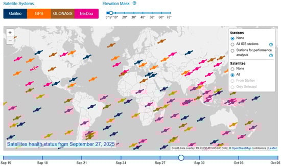
Figure 1.
Global coverage of Global Navigation Satellite System (GNSS) (licensed under CC-BY-NC-ND 3.0) [12].
2.1. GPS
The Global Positioning System (GPS) was started by the Department of Defense (DoD) and the National Aeronautics and Space Administration (NASA). They were developing a satellite system for three-dimensional position determination, initially for military purposes and later for civilian use [1]. GPS consists of a constellation of at least 24 active satellites distributed across six orbital planes, positioned at an altitude of approximately 20,200 km above the Earth’s surface. Each of these orbital planes has an inclination of about 55° relative to the Earth’s equatorial plane, which ensures global coverage with a minimum of four visible satellites from any point on the planet at any given time. The satellite altitude and orbital inclination allow the system to operate independently of the user’s geographic latitude [14].
The GPS constellation is composed of 31 satellites launched over four decades, including six Block IIR (Replenishment), seven Block IIR-M (Modernized), twelve Block IIF (Follow-On), and six GPS III/IIIF satellites. Block IIA (Advanced) satellites are no longer in use, with the last one decommissioned in 2019 [14]. A key focus of the GPS modernization program was the deployment of new signals for civilian use: L2C (enhanced accuracy and dual-frequency capability), L5 (Safety-of-life signal for critical applications), and L1C (designed for interoperability with multi-GNSS). These signals operate alongside the legacy of L1 C/A signal, making a total of four civil GPS signals. The new civil signals are being introduced gradually, as newer satellites replace older ones [14,15]. The L1 frequency, transmitted by all GPS satellites, carries both a coarse/acquisition (C/A) code ranging signal and a navigation data message available for civilian, commercial, and scientific use. It also includes a precision P(Y) code ranging signal and navigation message, which are accessible only to users with valid cryptographic keys. Additionally, GPS satellites transmit a second P(Y) code ranging signal and navigation message on the L2 frequency. GPS uses the World Geodetic System 1984 (WGS84), which is in good agreement with the realization of the International Terrestrial Reference System (ITRS) [16].
The last launched GPS satellite is GPS III SV-08, which was launched on 30 May 2025. This satellite is the eighth in the GPS III series and is part of the modernization of the United States GPS constellation managed by the U.S. Space Force (USSF). The launch was conducted using a SpaceX Falcon 9 rocket from Cape Canaveral Space Force Station in Florida. The satellite was successfully placed into its targeted orbit, and the rocket’s booster safely landed on a drone ship in the Atlantic Ocean [17].
2.2. GLONASS
GLONASS is Russia’s satellite-based global navigation system, designed to provide real-time PNT information worldwide. GLONASS consists of a constellation of satellites orbiting in MEO, arranged in three orbital planes. It offers accurate location data for both civilian and military users, supporting a range of applications from navigation and transportation to emergency services and geodesy. The system is undergoing a major modernization, transitioning from Frequency Division Multiple Access (FDMA) to Code Division Multiple Access (CDMA) signals. The full transition to CMDA is planned by 2030 with GLONASS-K and K2 satellites and ensures greater interoperability, improved accuracy and the use of simpler receivers [1,18]. The constellation includes around 26 satellites from three generations (Figure 2): 21 GLONASS-M, four GLONASS-K (one of which is currently not operational), and one GLONASS-K2 [19].
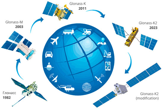
Figure 2.
Development of GLONASS (Copyright © Applied Consumer Center of the State Corporation “Roscosmos”) [18].
The latest satellite launched was the GLONASS-K2 (Kosmos-2584) in March 2025. Following that, the first GLONASS-V is expected to launch around 2026–2027 into a Highly Elliptical Orbit (HEO). These satellites are designed to operate in HEO, complementing the current MEO constellation by providing improved coverage and signal strength in high-latitude areas where GLONASS currently has limited visibility.
Since 2012, the official geodetic reference frame has been PZ-90.11, closely aligned with the International Terrestrial Reference Frame 2008 (ITRF2008) and compatible with WGS84. It allows integration with other GNSSs and provides centimeter positioning accuracy [5].
2.3. Galileo
Galileo is the European Union’s GNSS, fully operational since December of 2016. It provides precise and reliable positioning and timing data, which is used in smartphones as well as across various sectors such as aviation, rail transport, agriculture, maritime navigation, and more. The FOC consists of 24 satellites orbiting the Earth at an altitude of 23,000 km, but the current constellation has 27 active satellites. Compared to GPS, Galileo offers three times greater accuracy, achieving precision levels of up to one meter, and supports a wide range of applications and services [20].
While European independence is a principal objective of the program, Galileo also gives Europe a seat at the rapidly expanding GNSS global table. The program is designed to be compatible with all existing and planned GNSS and interoperable with GPS and GLONASS. In this sense, Galileo is positioned to enhance the coverage currently available providing a more seamless and accurate experience for multi-constellation users around the world [21]. Galileo is a component of the EU Space Program. It allows the EU and its Member States to remain independent in case other GNSS become degraded or switched off and to ensure sovereignty and autonomy in space [20,22].
Galileo’s Open Service (OS) operates on the E1, E5a, and E5b frequency bands, supporting both dual- and triple-frequency positioning. The Safety-of-Life (SoL) service is integrated within the OS signals via the I/NAV message, which includes integrity information. The Commercial Service (CS) uses the E6-C frequency band at 1278.75 MHz for advanced data applications (Figure 3). The Public Regulated Service (PRS) signals, transmitted on E1-A and E6-A, are encrypted, and reserved for authorized users. Lastly, the High Accuracy Service (HAS) utilizes the E6-B signal to provide Precise Point Positioning (PPP) corrections, enabling positioning accuracy of approximately 20 cm [10,11].
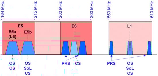
Figure 3.
Galileo services and frequencies (Copyright © ESA/NASA—SOHO/LASCO) [23].
2.4. BDS
China has pursued a clear and strategic vision in the development and implementation of its Beidou Navigation Satellite System (BDS). The primary purpose of this initiative has been to support national economic and social development, enhance national security, provide continuous, stable, and reliable services to global users, stimulate the growth of the domestic space industry, improve the overall quality of life, and strengthen international cooperation. A key guiding principle throughout this process has been the phased construction of an independent global navigation satellite system that offers free services to users, while remaining compatible and interoperable with other GNSS. This approach aims to foster international collaboration and data exchange, thereby improving service delivery to end users [1].
BDS utilizes three types of orbits to achieve global coverage and high positioning accuracy. The development of BDS progressed through three phases, starting with the establishment of a basic infrastructure with limited coverage, followed by regional expansion, and global coverage in third phase with the implementation of advanced navigation and communication services [24]:
- BeiDou-1 (2000–2012): the initial demonstration system consisted of three GEO satellites and provided limited coverage over China and neighboring regions. It offered rudimentary positioning services primarily for domestic applications;
- BeiDou-2 or COMPASS (2012–2020): this second phase expanded coverage across the Asia-Pacific region, incorporating a hybrid constellation of GEO, IGSO, and MEO satellites;
- BeiDou-3 or BDS (2020–present): with the completion of BeiDou-3 in July of 2020, China achieved full global coverage, supported by a constellation of 35 operational satellites. The system now provides open and authorized services globally with improved accuracy, integrity, and availability.
BDS operates across multiple frequency bands to ensure compatibility, redundancy, and improved positioning accuracy. The primary frequency bands include B1 (1561–1575 MHz), B2 (1176–1207 MHz), and B3 (1268 MHz). Within these bands, different signal types are transmitted, such as B1I, B1C, B2a, B2b, and B3I, supporting both legacy and modernized services. B1C and B2a signals are designed to be interoperable with GPS (L1C and L5) and Galileo (E1 and E5a), enhancing GNSS performance for civilian users. The use of multiple frequencies allows more effective ionospheric error correction, increased signal reliability, and higher precision in both regional and global applications [1,25].
3. Regional Navigation Satellite System (RNSS)
In contrast to GNSS, a Regional Navigation Satellite System (RNSS) is designed to cover specific geographic areas, which allows for reduced costs, increased positioning accuracy within priority zones, and greater geopolitical and technological independence. RNSS is increasingly used to complement GNSS by providing additional signals that enhance the accuracy and reliability of navigation. This section provides an overview of the key RNSS currently in operation or under development, their technical characteristics, operational principles, and their role in the broader context of satellite positioning and navigation technologies (Table 2).
Table 2.
Overview of RNSS.
3.1. QZSS
The Quasi-Zenith Satellite System (QZSS) is a regional satellite navigation system developed and operated by the Government of Japan in cooperation with QZS Service Inc. Its primary objective is to complement GPS by enhancing the accuracy and availability of positioning services across East Asia and Oceania, particularly in Japan’s challenging urban environments. QZSS began official operations in 2018 with four satellites, and by 2023, the constellation had expanded to seven satellites, providing autonomous positioning capability independent of GPS [6].
QZSS employs a hybrid orbital configuration consisting of three satellites in IGSO and one satellite in a geostationary orbit. The IGSO satellites operate at altitudes ranging from approximately 32,000 km to 40,000 km, with inclinations between 39° and 47°, and an orbital period of about 24 h. This configuration ensures that at least one satellite is positioned nearly overhead Japan at any given time, thereby improving signal availability and reducing signal blockage in urban canyons (Figure 4). The GEO satellite, located at an altitude of approximately 35,786 km, provides additional signal support and augmentation [26].
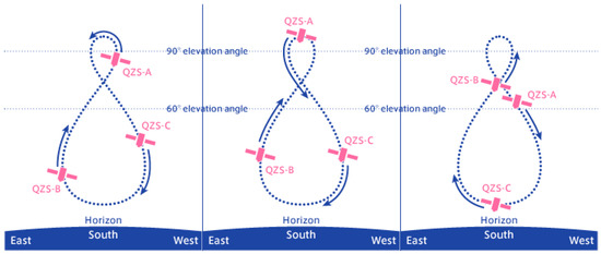
Figure 4.
Satellites trajectory of the Quasi-Zenith Satellite System (Copyright © National Space Policy Secretariat, Cabinet Office) [27].
The system’s Signal-in-Space User Range Error (SIS-URE) is specified to be less than 2.6 m (with a 95% confidence interval), while performance evaluations in 2020 demonstrated even better accuracy, with SIS-URE values ranging from 0.52 m to 1.10 m [28]. Augmentation services such as the Submeter Level Augmentation Service (SLAS) provide horizontal accuracies between 0.38 m and 0.84 m, and vertical accuracies of up to 1.11 m [28]. The Centimeter Level Augmentation Service (CLAS) enables positioning accuracies of 1.3 to 2.7 cm horizontally [28]. QZSS satellites transmit GPS-compatible L1C/A, L1C, L2C, and L5 signals and supports multi-frequency positioning and delivers precise orbit and clock correction data [28].
3.2. IRNSS
The Indian Regional Navigation Satellite System (IRNSS) is designed and deployed by the Indian Space Research Organisation (ISRO). It is intended to provide accurate positioning services over the Indian subcontinent and up to 1500 km beyond its borders. IRNSS initially consisted of seven satellites launched between 2013 and 2018, establishing the primary operational constellation (Figure 5). To enhance and modernize the system, India began launching second-generation IRNSS satellites. The first of these, IRNSS-1J, was successfully launched in May 2023, introducing improved atomic clocks and new civilian signals on the L1 frequency. This marked a significant upgrade to the system’s capabilities and reliability. The next second-generation satellite, IRNSS-1K, was launched in January 2025 but suffered propulsion issues, limiting its operational deployment [1,29,30].
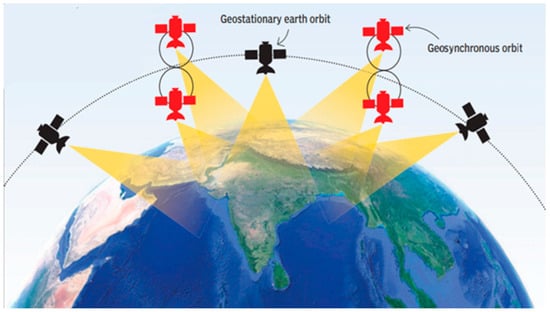
Figure 5.
The Indian Regional Navigation Satellite System (IRNSS) orbits (Copyright © Times Syndication Service) [31].
IRNSS provides two primary services: the Standard Positioning Service (SPS), available to civilian users with positioning accuracy better than 10 m within the Indian region, and the Restricted Service (RS), intended for authorized users, offering accuracy better than 5 m [32]. These levels of accuracy are supported by atomic clocks onboard the satellites, which are essential for precise timekeeping. In addition to supporting national development, India and the United States signed a cooperation agreement in 2007 to enhance interoperability between GPS, IRNSS, and GAGAN. This collaboration aims to improve regional navigation accuracy and reliability, particularly for civil aviation and strategic applications [5].
IRNSS uses the WGS84 coordinate system for navigation solution computations and represents a strategic regional navigation system developed with indigenous technology and strengthened through international cooperation. The deployment of second-generation satellites is expected to further improve the system’s accuracy and coverage [29,30].
3.3. KPS
The Korean Positioning System (KPS) is a regional navigation satellite system currently under development by the Korea Aerospace Research Institute (KARI). Development of the system began in 2022, the first launch is expected in 2027, and the goal is to achieve FOC by 2035. KPS represents a strategic effort to establish national autonomy in satellite navigation, reduce reliance on foreign GNSSs, and enhance positioning accuracy within the Korean Peninsula and surrounding regions. The system is being designed to operate interoperably with GPS, ensuring compatibility with existing GNSS infrastructure and user equipment [33].
KPS will consist of a constellation of seven satellites, including three geostationary and four inclined geosynchronous orbit satellites. This configuration is optimized to provide continuous and highly accurate positioning services over the Korean region, even in challenging environments such as urban canyons and mountainous terrain [2,34].
The system is expected to support sub-meter positioning accuracy when used in conjunction with GPS signals, with planned signal transmissions in the L1, L2, and L5 frequency bands [34]. One of the key motivations behind KPS is to strengthen national security and ensure the resilience of navigation services against jamming and spoofing, particularly during times of crisis or conflict. The project also aligns with broader objectives to enhance South Korea’s space capabilities and to establish a domestic technological foundation in satellite system development [33].
4. Satellite-Based Augmentation System (SBAS)
Satellite-Based Augmentation System (SBAS) is regional system designed to enhance the performance of GNSS, particularly in terms of accuracy, integrity, continuity, and availability. They achieve this by broadcasting correction and integrity data through geostationary satellites to users within their service regions. SBASs are especially critical for safety-critical applications such as civil aviation, but also support a wide range of other domains including agriculture, transportation, and disaster management [35]. ICAO Annex 10 sets strict requirements for the accuracy and integrity of radionavigation and communication systems in air traffic to ensure flight safety. The accuracy of systems such as GNSS, the Instrument Landing System (ILS), and the VHF Omnidirectional Range (VOR) must fall within defined limits. GNSS systems achieve horizontal accuracy within 1 m to 3 m, while ILS systems provide accuracy of approximately 5 m in the final approach area. System integrity refers to the ability to promptly detect and report faults, with maximum fault detection times often under 6 s for GNSS. These specifications enable pilots and air traffic controllers to rely on precise and dependable information, thereby reducing the risk of unsafe situations during navigation and flight management [36]. Below is an overview of the major SBASs currently in operation, development, or planning (Table 3).
Table 3.
Satellite-Based Augmentation System (SBAS).
According to available information, currently there are six operational SBASs. Figure 6 shows coverage area of each SBAS, regardless of its status. Present state of SBAS does not include territories of South America, Greenland and northern parts of Canada, and some regions of Africa, as well as Indonesian Archipelago.
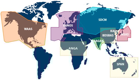
Figure 6.
Coverage areas of all nine Satellite-Based Augmentation Systems (SBASs) (Copyright © 2025 SatNav-Africa Joint Programme Office) [35].
4.1. WAAS
The Wide Area Augmentation System (WAAS) is operated by the United States Federal Aviation Administration (FAA). It provides enhanced GNSS services across North America, including the U.S., Canada, and Mexico. Since its launch in 2003, WAAS has primarily supported precision landings in civil aviation. However, WAAS applications extend to smart agriculture, surveying and mapping, transportation and logistics, and emergency services [37]. The WAAS system currently operates using three active geostationary satellites: Eutelsat 117 West B, SES-15, and Galaxy 30. These satellites transmit differential corrections and integrity information for GNSS signals in real time, significantly improving positioning accuracy to better than 2 m [38]. The key advantages of the WAAS includes high accuracy, integrity, availability, and continuity of service, making it especially suitable for aviation applications such as precision approach procedures without the need for additional ground-based navigation aids. In addition to corrections, WAAS satellites additional ranging sources, further enhancing the reliability of GNSS positioning [38].
4.2. SDCM
System for Differential Corrections and Monitoring (SDCM) is developed by the Russian space agency Roscosmos. It’s designed to enhance the performance of GLONASS and GPS signals over Russian territory and surrounding regions. The system currently operates two geostationary satellites that broadcast SBAS correction messages on the L1 frequency, in compliance with ICAO SBAS standards. This enables its use in civil aviation and other high-accuracy applications. SDCM improves positioning accuracy to 1.5 m and provides real-time integrity monitoring. Key benefits include enhanced precision, reliability, and support for safety-critical operations, such as aviation approaches. Although not yet certified for Safety-of-Life operations, SDCM is under continuous development to achieve full compliance with ICAO SARPS requirements [39,40].
4.3. EGNOS
European Geostationary Navigation Overlay Service (EGNOS) managed by the European Union Agency for the Space Programme (EUSPA). EGNOS covers Europe and parts of North Africa and the Middle East. It has been operational since 2009 and is currently evolving into version 3, which will include support for Galileo signals. EGNOS currently operates three geostationary satellites. These satellites broadcast GNSS correction messages and integrity data in real time, enhancing GPS performance for safety critical applications (Figure 7). EGNOS improves horizontal positioning accuracy to below 1–2 m [38] and provides integrity monitoring by detecting and alerting users to GNSS signal. Key benefits of EGNOS include increased accuracy, safety, and service reliability, particularly in civil aviation for precision approach procedures at airports without requiring ground-based navigation infrastructure. EGNOS is also used in agriculture, maritime, surveying, and other domains that benefit from enhanced GNSS precision and reliability [40].
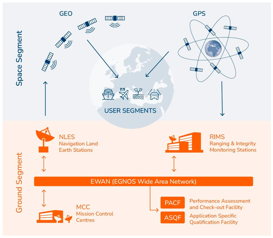
Figure 7.
Infrastructure of European Geostationary Navigation Overlay Service (Copyright © EUSPA 2021–2025) [41].
4.4. BDSBAS
BeiDou Satellite-Based Augmentation System (BDSBAS) is being developed as part of the broader BeiDou Navigation Satellite System. It is intended to serve the Asia-Pacific region to provide high-integrity GNSS augmentation services. BDSBAS is an important part of BDS and will provide the Single Frequency (SF) service through BDSBAS-B1C signal and the Dual-Frequency Multi-Constellation (DFMC) service through BDSBAS-B2a signal for users in China and surrounding areas, in accordance with the ICAO standards. The first BDSBAS satellite was successfully launched in November 2018. The reference coordinate system is WGS84 [42,43].
4.5. MSAS
MTSAT Satellite-Based Augmentation System (MSAS) developed by the Japan Civil Aviation Bureau (JCAB). MSAS is operational since 2007 and provides augmentation services over Japan and parts of East Asia. As of 2023, there is only one QZSS GEO satellite, so MSAS correction information is transmitted from only one GEO satellite, and it is difficult to judge it as fully operational. It is primarily focused on improving aviation navigation services and is fully compatible with GPS, as show in Figure 8 [38].
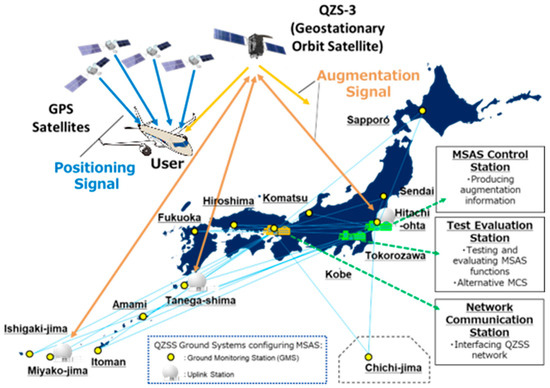
Figure 8.
Configuration of MTSAT Satellite-Based Augmentation System (MSAS) (Copyright © NEC Corporation 1994–2025) [44].
4.6. GAGAN
The Global Positioning System (GPS) Aided Geostationary Earth Orbit (GEO) Augmented Navigation (GAGAN) is a joint initiative by the Indian Space Research Organisation (ISRO) and the Airports Authority of India (AAI). It has been fully operational since 2015. GAGAN broadcasts SBAS navigation data using three GEO satellites on L1 and L5 signals for SBAS data transmission. It enhances GNSS performance over the Indian subcontinent, supporting both aviation and broader regional navigation applications [35,38].
4.7. KASS
The Korean Augmentation Satellite System (KASS) is South Korea’s SBAS developed under the management of Korea Aerospace Research Institute (KARI). The project was launched in 2013. The system uses two geostationary satellites, one of which is active while the other is in development, and it transmits signals on the GPS L1 frequency. The system provides horizontal accuracy of up to 1.5 m [38].
4.8. SouthPAN
Southern Positioning Augmentation Network (SouthPAN) is a collaborative effort between Australia and New Zealand. SouthPAN is being implemented to provide SBAS coverage across Australia, New Zealand, and parts of the South Pacific. Initial services began in 2022, with full aviation-certified service expected by 2028. It will deliver improved accuracy and integrity for diverse applications, including autonomous systems and resource management in addition to provide GPS L1 C/A and L5 signals, and Galileo E1 and E5a signals using PPP services with an accuracy of up to 10 cm [45].
4.9. ANGA
Augmented Navigation for Africa (ANGA) developed by the Agency for the Safety of Air Navigation in Africa and Madagascar (ASECNA), which consists of 18 countries in Africa and the Indian Ocean. It provides autonomous services to users using a technology based on EGNOS. In July of 2021, a successful demonstration of Precise Point Positioning and Early warning services has been conducted. ANGA employs one GEO satellite to broadcast SBAS corrections using the L1 and L5 frequencies. The system is designed to expand to three GEO satellites positioning accuracy to 1 m, with the reference coordinate system is WGS84. It is expected to enhance aviation safety and support broader regional development through improved satellite navigation infrastructure [35,46].
5. Discussion
This review presents an overview of the modernization of GNSS, RNSS, and SBAS, from the first satellite launches to the most recent developments, based on available and recent literature.
GNSS provides global coverage and has a wide range of applications. RNSS focus on specific geographic areas, offering precision and reliability tailored to local needs. SBASs further improve the accuracy, integrity, and availability of GNSS signals, which is essential for the safety of critical applications such as civil aviation and maritime navigation.
GNSS and RNSS form the modern infrastructure of PNT. From global positing and real-time navigation to time synchronization, PNT technologies enable the functioning of key sectors of society and the economy. Key technical elements, such as satellite orbits and the frequency spectrum used to transmit signals, significantly affect the performance and applicability of each system.
The key data in this review are summarized in Table 4. As of 28 September 2025, a total of 117 GNSS and 10 RNSS satellites are operational.
Table 4.
Frequencies and Services of GNSS and RNSS on 28 September 2025 [1,2,3,5,21,22,24,26,31,38].
The accuracy data in Table 4 refers to absolute positioning within a 95% confidence interval under optimal conditions, with good signal reception, open skies, and minimal multipath effects. However, it is important to note that actual accuracy can vary significantly depending on factors such as the use of multi-frequency receivers, satellite geometry, environmental conditions (e.g., urban canyons), and the application of correction systems in positioning methods (RTK or PPP).
Advanced services such as CLAS (QZSS), and HA (KPS) enable high accuracy (at the decimeter level) using additional corrections. In contrast, services like PPS (GPS), HP (GLONASS), PRS and HAS (Galileo), AS (BDS), and RS (IRNSS) are encrypted and intended for authorized users only. The SAR service (Galileo) does not provide a navigation function but enables the location of people in distress, where the accuracy refers to the precision of determining their location, not the position of the user. For relative positioning (using data from multiple receivers and comparing data), accuracy can be much higher, potentially reaching centimeter or even millimeter levels, but this is not the focus of the current analysis.
The L-band (1–2 GHz) and S-band (2–4 GHz) are segments of the radio frequency spectrum used in satellite navigation, each serving distinct roles. The L-band is the primary frequency range for all global GNSSs. These signals offer high reliability, strong atmospheric penetration, and are well-suited for positioning applications in aviation, surveying, autonomous systems, and mobile devices. S-band is not commonly used for basic GNSS signals and is currently only used by IRNSS. It supports higher data rates and increased resilience to certain types of interference, although it has slightly reduced propagation capability through obstacles compared to the L-band. Beyond navigation, the S-band is widely used in radar systems, satellite communications, and telemetry. In summary, the L-band forms the backbone of global satellite navigation, while the S-band serves specific regional and technical functions, particularly in communication and radar domains [47].
5.1. Impact of Brexit—UKSBAS
The United Kingdom’s withdrawal from the European Union (Brexit) had a significant impact on the access of British institutions and users of Galileo and EGNOS. Following Brexit, the UK lost its right to participate in the development of these systems and was excluded from access to security-sensitive services such as the encrypted Public Regulated Service (PRS) signal and the EGNOS Safety-of-Life (SoL) function. Although civilian users in the UK can still access the open service signals of both Galileo and EGNOS, British companies are no longer eligible to compete in EU tenders or contribute to the development of technologies within the European navigation programs. The UK government considered developing its own navigation system. Due to the high estimated cost, the project was eventually abandoned. After that, the UK developed UKSBAS, a satellite-based augmentation system that relies on GPS and covers UK territory, as a temporary substitute for the EGNOS SoL service [48,49].
Situations such as Brexit highlight the strategic importance of GNSS infrastructure and demonstrate how geopolitical decisions can have direct technical and economic consequences for a nation’s navigational autonomy.
5.2. Global Internet Network—Starlink
Starlink is a satellite internet constellation operated by a private aerospace company, SpaceX. It currently has over 8000 active satellites in LEO, arranged in multiple layers at altitudes between 540 km and 570 km. The satellites are divided into orbital groups with different inclinations. The largest number of satellites is concentrated in groups with an inclination of around 53°, enabling global internet access with low latency. SpaceX plans to expand the network to more than 40,000 satellites, which will provide faster internet access but also pose challenges such as space debris and interference with astronomical observations [50,51]. Starlink provides valuable internet access to remote and underserved areas, but a large survey using a prototype of the Square Kilometre Array (SKA-Low) station detected over 112,000 emission events from 1806 unique Starlink satellites. Some of these emissions occurred within frequency bands reserved for radio astronomy (such as 73–74 MHz and 150–153 MHz). These results emphasize that the growing number of satellites poses challenges not only to visual astronomy through reflections and trails, but also to radio astronomy due to electromagnetic interference, as well as increasing risks related to space debris. Together, these issues threaten the sustainable use of Earth’s orbital environment [52].
5.3. Innovations in Croatia—CroCube
Croatia signed a Cooperation Agreement with the European Space Agency (ESA) in 2018 and became a European Cooperating State (ECS) in August 2023. CroCube is the first Croatian nanosatellite, marking a historic milestone for Croatia’s entry into the space sector. The launch was successfully completed in December 2024, using a Falcon 9 rocket, owned by aerospace company SpaceX. It is a CubeSat (10 × 10 × 10 cm, Figure 9) developed by a private volunteer initiative Team CroCube in cooperation with the Slovak company Spacemanic. CroCube was launched into LEO at approximately 510 km. CroCube enables Earth observation capabilities and marks a significant step in developing the national space sector [53,54].
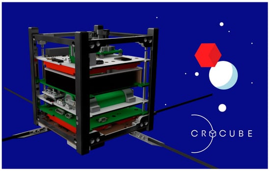
Figure 9.
CroCube satellite (Copyright © 2020 Croinvest.eu) [55].
6. Conclusions
GNSS, RNSS, and SBAS represent the foundation of modern satellite navigation and are key to further technological progress. Although these systems are already advanced and widely deployed, they face new challenges and opportunities. Increasing accuracy, immunity to interference, and integration with other technologies, such as 5G networks, artificial intelligence, and autonomous systems, are the directions of future development. Also, mutual interoperability and standardization of systems will play an important role in the global cohesion of navigation services. Their synergy enables the development of reliable and precise PNT services solutions that will play an even greater role in our daily lives and industrial processes in the future.
Furthermore, the integration of GNSS systems with LEO satellite constellations represents a significant advancement in the development of next-generation PNT solutions. The combination of stronger signal strength, greater spatial and temporal availability, and faster dynamics of LEO satellites enables higher positioning accuracy and improved resilience against interference and spoofing attacks, particularly in challenging urban and indoor environments. Additionally, the implementation of AI-based integrity monitoring systems further enhances the reliability and safety of navigation solutions through automated anomaly detection and real-time error prediction. This technological synergy between GNSS–LEO integration and AI-based approaches forms the foundation for a new generation of robust and scalable PNT systems applicable in critical infrastructure, transportation, and defense sectors.
In conclusion, the overall world situation is changing daily and significantly affects all aspects of the autonomy of individual countries, including events in space. This modernization of GNSS, RNSS, and SBAS enables a significant increase in the number of satellites and innovations in space technology, addressing both military and civilian needs for greater precision in applications such as surveying, transportation, disaster management, agriculture, and urban planning.
Author Contributions
Conceptualization, K.Š. and M.Z.; methodology, K.Š. and M.Z.; validation, K.Š., M.Z., A.T. and K.S.; formal analysis, A.T. and K.S.; investigation, K.Š.; writing—original draft preparation, K.Š.; writing—review and editing, K.Š., M.Z., A.T. and K.S.; visualization, K.Š., A.T. and K.S.; supervision, M.Z.; project administration, K.Š.; funding acquisition, M.Z. All authors have read and agreed to the published version of the manuscript.
Funding
This research was funded by the University of Zagreb under the research project “Automatization of measurement procedure in the Laboratory for Measurements and Measuring Technique of the Faculty of Geodesy”.
Data Availability Statement
No new data were created or analyzed in this study. Data sharing is not applicable to this article.
Conflicts of Interest
The authors declare no conflicts of interest.
References
- Kaplan, E.D.; Hegarty, C. Understanding GPS: Principles and Applications, 2nd ed.; Artech House mobile communications series; Artech House: Boston, MA, USA, 2006; ISBN 978-1-58053-894-7. [Google Scholar]
- Hein, G.W. Status, Perspectives and Trends of Satellite Navigation. Satell. Navig. 2020, 1, 22. [Google Scholar] [CrossRef] [PubMed]
- Langley, R.B. Innovation: GLONASS—Past, Present and Future. Available online: https://www.gpsworld.com/innovation-glonass-past-present-and-future (accessed on 21 August 2025).
- Zrinjski, M.; Bačić, Ž.; Barković, Đ. Modernization of GPS (GNSS-2). Geod. List 2005, 59, 45–61. [Google Scholar]
- Zrinjski, M.; Barković, Đ.; Matika, K. Development and Modernization of GNSS. Geod. List 2019, 73, 45–65. [Google Scholar]
- Hegarty, C.J.; Chatre, E. Evolution of the Global Navigation Satellite System (GNSS). Proc. IEEE 2008, 96, 1902–1917. [Google Scholar] [CrossRef]
- Another Lockheed Martin-Built GPS III Satellite Lifts Off into Orbit. Available online: https://investors.lockheedmartin.com/news-releases/news-release-details/another-lockheed-martin-built-gps-iii-satellite-lifts-orbit (accessed on 12 September 2025).
- Bhattacharjee, N.; Bhattacharjee, N. India Sends Navigation Satellite into Orbit on ISRO Rocket in Landmark Launch. Available online: https://www.reuters.com/technology/space/india-sends-navigation-satellite-into-orbit-isro-rocket-landmark-launch-2025-01-29 (accessed on 12 September 2025).
- Successful Launch of Two New Galileo Satellites-European Commission. Available online: https://defence-industry-space.ec.europa.eu/successful-launch-two-new-galileo-satellites-2024-09-18_en (accessed on 12 September 2025).
- Chen, J.; Zhang, Y.; Yu, C.; Wang, A.; Song, Z.; Zhou, J. Models and Performance of SBAS and PPP of BDS. Satell. Navig. 2022, 3, 4. [Google Scholar] [CrossRef]
- Romaniuc, A.-G.; Vasile, V.-C.; Borda, M.-E. Global Navigation Satellite System Spoofing Attack Detection Using Receiver Independent Exchange Format Data and Long Short-Term Memory Algorithm. Information 2025, 16, 502. [Google Scholar] [CrossRef]
- GNSS Performance Monitoring. Available online: https://gnss-monitoring.dlr.de/ (accessed on 8 September 2025).
- Awange, J.; Kiema, J. Modernization of GNSS. In Environmental Geoinformatics; Environmental Science and Engineering; Springer International Publishing: Cham, Switzerland, 2019; pp. 47–54. ISBN 978-3-030-03016-2. [Google Scholar]
- GPS.Gov: Space Segment. Available online: https://www.gps.gov/space-segment (accessed on 8 September 2025).
- GPS Constellation. Available online: https://www.navcen.uscg.gov/gps-constellation (accessed on 21 August 2025).
- International Committee on Global Navigation Satellite Systems: The Way Forward: 10 Years of Achievement, 2005–2015; United Nations: New York, NY, USA, 2016; ISBN 978-92-1-101333-7.
- U. S. Space Force Field Commands Successfully Launch GPS III. Available online: https://www.ssc.spaceforce.mil/Newsroom/Article/4202300/u-s-space-force-field-commands-successfully-launch-gps-iii-demonstrating-expedi (accessed on 8 September 2025).
- About GLONASS. Available online: https://glonass-iac.ru/en/about_glonass (accessed on 12 September 2025).
- Mooney, J. Soyuz-2.1b Launches Final GLONASS-M Satellite from Plesetsk. Available online: https://www.nasaspaceflight.com/2022/11/kosmos-2564 (accessed on 25 August 2025).
- Galileo, the European Union Global Navigation Satellite System-European Commission. Available online: https://defence-industry-space.ec.europa.eu/document/download/04ae75b0-e6b6-4a12-9e14-ecd9cd6c1a7a_en?filename=Galileo%20the%20EU%20GNSS%20Factsheet.pdf (accessed on 15 September 2025).
- Galileo-EU Agency for the Space Programme. Available online: https://www.euspa.europa.eu/eu-space-programme/galileo (accessed on 21 August 2025).
- Services-European GNSS Service Centre (GSC). Available online: https://www.gsc-europa.eu/galileo/services (accessed on 25 August 2025).
- Galileo Navigation Signals and Frequencies. Available online: https://www.esa.int/Applications/Satellite_navigation/Galileo/Galileo_navigation_signals_and_frequencies (accessed on 25 August 2025).
- CNSS (Compass/BeiDou Navigation Satellite System)-EoPortal. Available online: https://www.eoportal.org/satellite-missions/cnss (accessed on 26 August 2025).
- Yan, Z.; Fraire, J.; Zhao, K.; Yan, H.; Madoery, P.G.; Li, W. Distributed Contact Plan Design for GNSS. IEEE Trans. Aerosp. Electron. Syst. 2019, 56, 660–672. [Google Scholar] [CrossRef]
- QZSS (Quasi-Zenith Satellite System)-Cabinet Office (Japan). Available online: https://qzss.go.jp/en/index.html (accessed on 20 August 2025).
- Quasi-Zenith Satellite Orbit (QZO). Available online: https://qzss.go.jp/en/technical/technology/orbit.html (accessed on 9 September 2025).
- QZSS (Quasi Zenith Satellite System). Available online: https://www.eoportal.org/satellite-missions/qzss#qzss-signals (accessed on 27 August 2025).
- Rao, V. Irnss. In Position, Navigation, and Timing Technologies in the 21st Century; John Wiley & Sons, Ltd.: Hoboken, NJ, USA, 2020; pp. 171–185. ISBN 978-1-119-45844-9. [Google Scholar]
- Indian Space Research Organisation. Available online: https://www.isro.gov.in/index.html (accessed on 20 August 2025).
- Indian Regional Navigation Satellite System: All You Need to Know. Times India 2017, 15.
- Indian Space Research Organisation. Available online: https://www.isro.gov.in/Navigation.html (accessed on 28 August 2025).
- Kim, G.; Park, C.; Lim, D.W. Space Service Volume Augmented with Korean Positioning System at Geosynchronous Orbit. J. Position. Navig. Timing 2020, 9, 327–336. [Google Scholar] [CrossRef]
- Choi, B.-K.; Roh, K.-M.; Ge, H.; Ge, M.; Joo, J.-M.; Heo, M.B. Performance Analysis of the Korean Positioning System Using Observation Simulation. Remote Sens. 2020, 12, 3365. [Google Scholar] [CrossRef]
- SBAS Systems Around the World. Available online: https://www.satnav-africa.com/index.php/en/gnss-and-sbas-at-a-glance/sbas-systems-around-the-world (accessed on 2 September 2025).
- ICAO Annex 10 Aeronautical Telecommunications Vol I. Radio Navigation Aids; International Civil Aviation Organization: Montréal, QC, Canada, 2018.
- Satellite Navigation-Wide Area Augmentation System (WAAS). Available online: https://www.faa.gov/about/office_org/headquarters_offices/ato/service_units/techops/navservices/gnss/waas (accessed on 2 September 2025).
- Kim, J.; Kim, Y.; Kim, J. Technology Trends of Satellite Based Augmentation Systems. J. Position. Navig. Timing 2024, 13, 25–34. [Google Scholar] [CrossRef]
- Revnivykh, I. GLONASS and SDCM Status and Development; ICG-14: Bengaluru, India, 2019. [Google Scholar]
- SDCM Space Segment. Available online: https://gssc.esa.int/navipedia/index.php/SDCM#SDCM_Space_Segment (accessed on 2 September 2025).
- EGNOS-EU Agency for the Space Programme. Available online: https://www.euspa.europa.eu/eu-space-programme/egnos (accessed on 2 September 2025).
- Cheng, L.; Weiguang, G.; Bo, S.; Jun, L.; Wei, W.; Ying, C.; Chengeng, S.; Shuai, X.; Qun, D. Development of BeiDou Satellite-Based Augmentation System. Navigation 2021, 68, 405–417. [Google Scholar] [CrossRef]
- BeiDou Navigation Satellite System. Available online: http://en.beidou.gov.cn (accessed on 3 September 2025).
- MSAS: Air Trafic Control and Airport System. Available online: https://www.nec.com/en/global/solutions/cns-atm/navigation/msas.html (accessed on 4 September 2025).
- Australia, G. Southern Positioning Augmentation Network (SouthPAN). Available online: https://www.ga.gov.au/scientific-topics/positioning-navigation/positioning-australia/about-the-program/southpan (accessed on 4 September 2025).
- ANGA-Association. Available online: https://www.anga-africa.org/en (accessed on 4 September 2025).
- Lee, S.; Han, K.; Won, J.-H. Assessment of Radio Frequency Compatibility for New Radio Navigation Satellite Service Signal Design in the L6-Band. Remote Sens. 2024, 16, 319. [Google Scholar] [CrossRef]
- UK Sovereign Satellite Navigation Overlay Successfully Demonstrated for First Time. Available online: https://www.viasat.com/news/latest-news/government/2024/uk-sovereign-satellite-navigation-overlay-successfully-demonstrated-for-first-time (accessed on 10 September 2025).
- UK & EU Space Programme–Brexit–An Irish Guide. Available online: https://brexitlegal.ie/uk-eu-space-programme (accessed on 10 September 2025).
- McDowell, J.C. The Low Earth Orbit Satellite Population and Impacts of the SpaceX Starlink Constellation. Astrophys. J. Lett. 2020, 892, L36. [Google Scholar] [CrossRef]
- Sesnic, T. Starlink Group 6-31|Falcon 9 Block 5. Available online: https://everydayastronaut.com/starlink-group-6-31-falcon-9-block-5 (accessed on 12 September 2025).
- Grigg, D.; Tingay, S.J.; Sokolowski, M. The Growing Impact of Unintended Starlink Broadband Emission on Radio Astronomy in the SKA-Low Frequency Range. Astron. Astrophys. 2025, 699, A307. [Google Scholar] [CrossRef]
- Petričević, I. GRBBeta. Available online: https://kozmos.hr/grbbeta-najmanji-astrofizicki-svemirski-opservatorij-i-zasto-je-vazan-za-crocube (accessed on 10 September 2025).
- CroCube. Available online: https://crocube.hr (accessed on 10 September 2025).
- Croinvest CroCube: Prva hrvatska kockica u svemiru. Available online: https://croinvest.eu/kampanja/crocube-prva-hrvatska-kockica-u-svemiru/ (accessed on 29 September 2025).


Disclaimer/Publisher’s Note: The statements, opinions and data contained in all publications are solely those of the individual author(s) and contributor(s) and not of MDPI and/or the editor(s). MDPI and/or the editor(s) disclaim responsibility for any injury to people or property resulting from any ideas, methods, instructions or products referred to in the content. |
© 2025 by the authors. Licensee MDPI, Basel, Switzerland. This article is an open access article distributed under the terms and conditions of the Creative Commons Attribution (CC BY) license (https://creativecommons.org/licenses/by/4.0/).