Article

Impact of Climate Change on Land Suitability for the Optimization of the Irrigation System in the Anger River Basin, Ethiopia

by
Meseret Dawit
1,2,*,
Megarsa Olumana Dinka
1,
Olkeba Tolessa Leta
3 and
Fiseha Behulu Muluneh
4
1
Department of Civil Engineering Sciences, Faculty of Engineering and the Built Environment, University of Johannesburg APK Campus, Auckland Park 2006, Johannesburg P.O. Box 524, South Africa
2
School of Water Resource & Environmental Engineering, Haramaya Institute of Technology, Haramaya University, Dire Dawa P.O. Box 138, Ethiopia
3
Bureau of Watershed Management and Modeling, St. Johns River Water Management District, 4049 Reid St, Palatka, FL 32177, USA
4
School of Civil and Environmental Engineering, Addis Ababa institute of Technology (AAiT), Addis Ababa University, Addis Ababa P.O. Box 385, Ethiopia
*
Author to whom correspondence should be addressed.
Climate 2020, 8(9), 97; https://doi.org/10.3390/cli8090097
Submission received: 9 June 2020 / Revised: 11 August 2020 / Accepted: 18 August 2020 / Published: 21 August 2020

Abstract

:
Evaluating climate change impacts and the suitability of potential land resources is crucial for sustainable irrigated agricultural systems. This study applied a multi-criteria analysis supported by the Geographic Information System (GIS) application to produce irrigation suitability maps for the Anger River basin’s (Ethiopia) irrigation command area to optimize its irrigation system. Six irrigation suitability factors, such as distance to water sources (rivers), slope, land use/land cover, soil texture, drainage, and depth, including climate change impacts, were used. These factors were spatially analyzed using a comparison matrix and overlying the factors with 30 m resolutions to estimate the potential irrigable area. About 40% of the study area was classified as moderately to highly suitable for surface water irrigation systems. Moreover, we found that a large proportion of the study area is suitable for surface irrigation system, suggesting the relevance of implementing an enhanced irrigation system for improving the surface irrigation water productivity of the basin. However, future climate change is predicted to negatively affect the irrigation suitable area due to water scarcity. Therefore, this study provides useful information on the irrigation suitability and potential of the study area that could be used to facilitate the water resource development and food security plans.

1. Introduction

The worldwide growth of the population has noticeably increased the demand for natural resources, such as water, land, and food [1,2]. On the other hand, climate change, caused by an increase in greenhouse gas emissions and global warming [3,4,5], has created an overall decline in rainfall and thus drought problems. This is further exacerbated by anthropogenic activities, such as over-farming, excessive irrigation, deforestation, and the over-exploitation of available water resources [6,7,8]. Consequently, climate change and the aforementioned anthropogenic activities may result in a reduction in freshwater resources that will, in turn, adversely affect the irrigation water availability and carrying capacity of the ecosystem [9,10,11].
Agriculture is the backbone of the Sub-Saharan economy and has been mostly practiced under a rain-fed system that is rarely supplemented with irrigation. In such systems, irrigation plays a significant role in alleviating poverty and facilitating sustainable development [12,13]. While water is one of the main factors that contribute to sustainable agricultural productivity, it also crucially contributes to the financial generation and economic growth of society [14]. Consequently, developing an irrigation system and enhancing its efficiency would improve crop productivity, thereby reducing dependence on rain-fed agriculture [4]. Several studies have proven that identifying the irrigation potential of an area could be a key factor to increase agricultural crop productivity [4,15]. Intensive irrigation water use and the demand for crop production are also expected to alter the microclimate of the irrigated areas [15]. Thus, alleviating poverty by practicing and enhancing irrigation systems, especially in developing countries (e.g., Ethiopia), is urgently needed.
Ethiopia has twelve major rivers that have significant water resource potential (about 122 Bm3 annual surface runoff and 2.9 Bm3 groundwater) [16,17,18]. Despite this fact, the country remains insufficient for agricultural food production due to its dependence on the rain-fed system. Moreover, the rivers are characterized by uneven spatial and temporal distributions [19]. Most of these rivers have trans-boundaries and flow to neighboring countries, such as Sudan and Egypt [20,21]. Ethiopia’s Ministry of Water Resources (MoWR) has highlighted that irrigation should be optimized to its maximum potential in terms of both utilizing existing resources and expanding cultivable land areas [22,23]. As a result, the total irrigated land of the country has increased from 160,000 ha (3%) to 250,000 ha (4.1%) for the period between 1990 and 2002 [16,24]. Ethiopia has shown fast growth in the economy and is targeted to achieve food security by 2030.
Moreover, agriculture production, which is practiced by more than 80.5% of the population of the country (approximately about 80 million), has significantly contributed to the country’s economy [22,25,26]. Furthermore, 65% of Ethiopia’s land is suitable for irrigation systems. However, much potential land has not yet been developed. Therefore, assessing the irrigation potential and land suitability for irrigation water use is vital for the development of irrigated agricultural planning and the improvement of agricultural productivity. According to the agricultural development of the country, irrigation technology and management practices play a significant role in economic growth [27].
In Ethiopia, the current traditional agricultural production system and the progressive degradation of available natural resources, particularly in highly susceptible areas of the country, together with climate change, have increased the pervasiveness of poverty and food insecurity [16,28]. This has been the main challenge in the country’s agricultural production sector. Therefore, understanding climate change’s impacts on land-use suitability and agricultural production, including assessing irrigation potential, plays a vital role in the irrigation development plan [29]. Several studies have also documented the importance of multi-criteria evaluations on land decision making for a different type of irrigation system [30,31,32,33]. Moreover, understanding the dynamics of land cover characteristics is a crucial factor to select an appropriate irrigation system for achieving sustainable water resources and irrigated agricultural production [2,34,35]. This study employs Geographic Information System (GIS) and Multi-Criteria Evaluation techniques to estimate the irrigation potential and land suitability of the Anger River basin (Ethiopia) as a case study for enhancing irrigation systems under different climate conditions. The basin is one of the tributaries to the Abbay River basin. This study mainly aims to understand and estimate the potential land suitability of the basin for irrigation-based agriculture development by considering the different factors affecting land suitability. This study will help pave the way for further investigations and analyses of water resource potential and possibly required interventions for the study area.

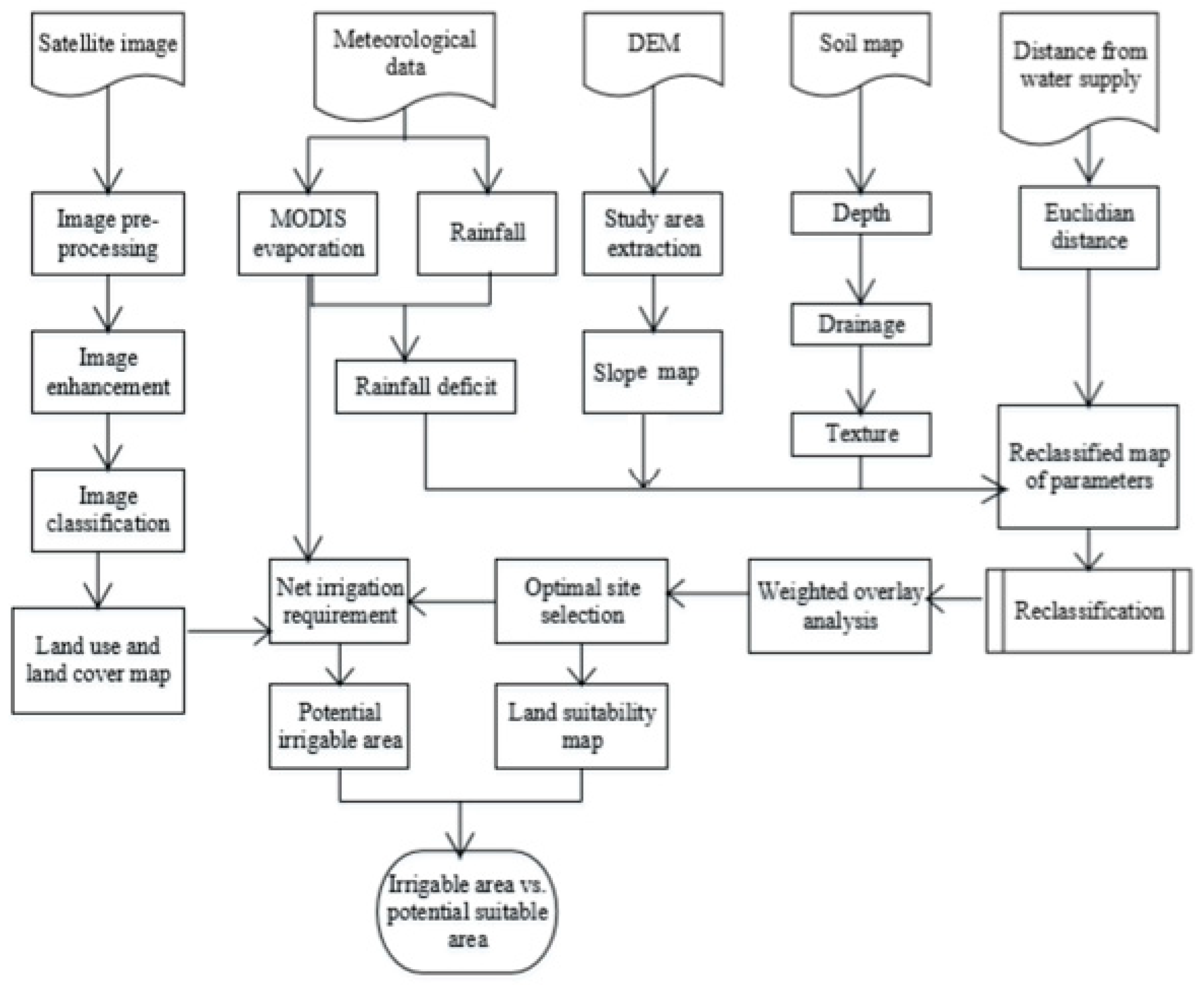
2. Materials and Methods

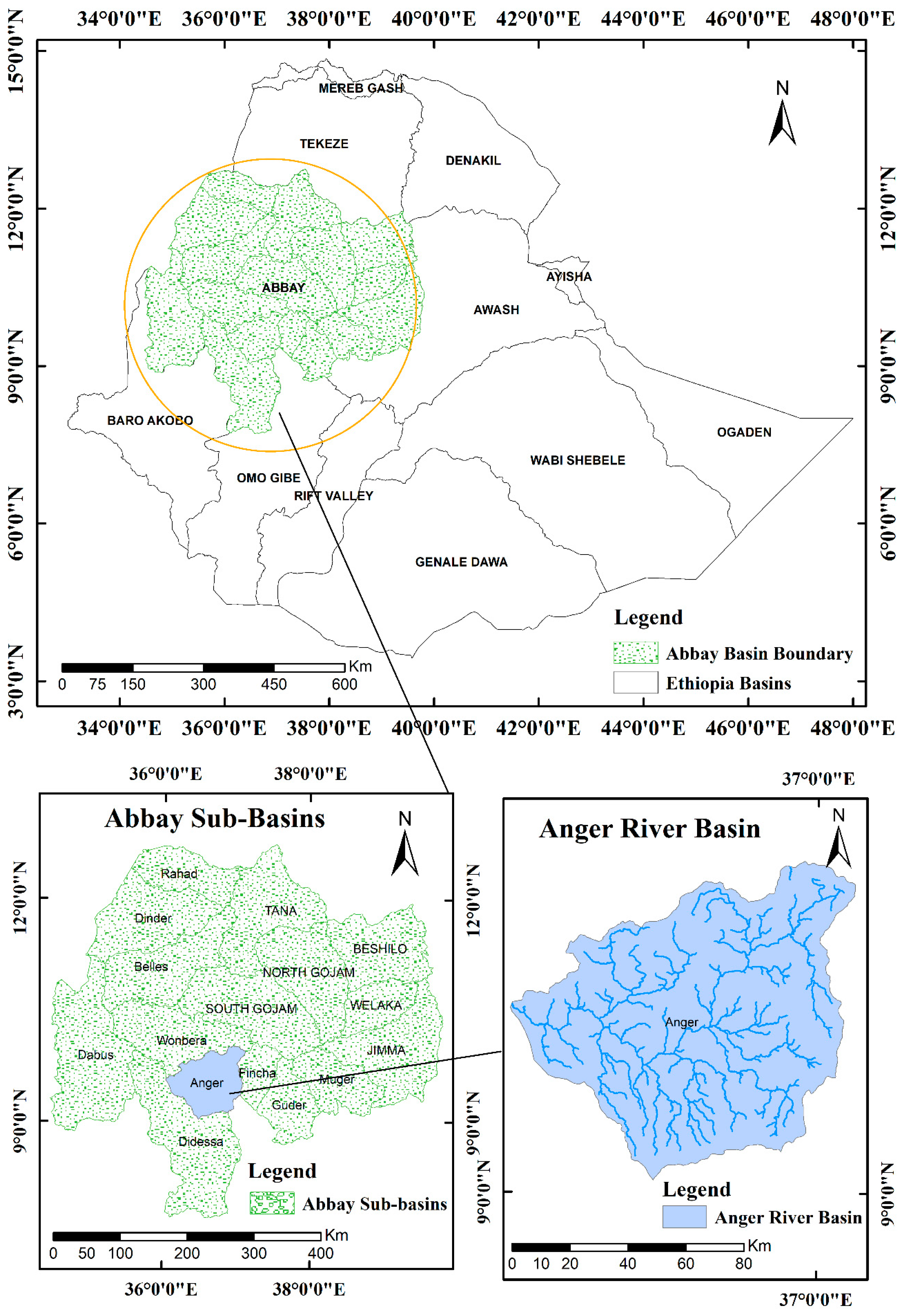
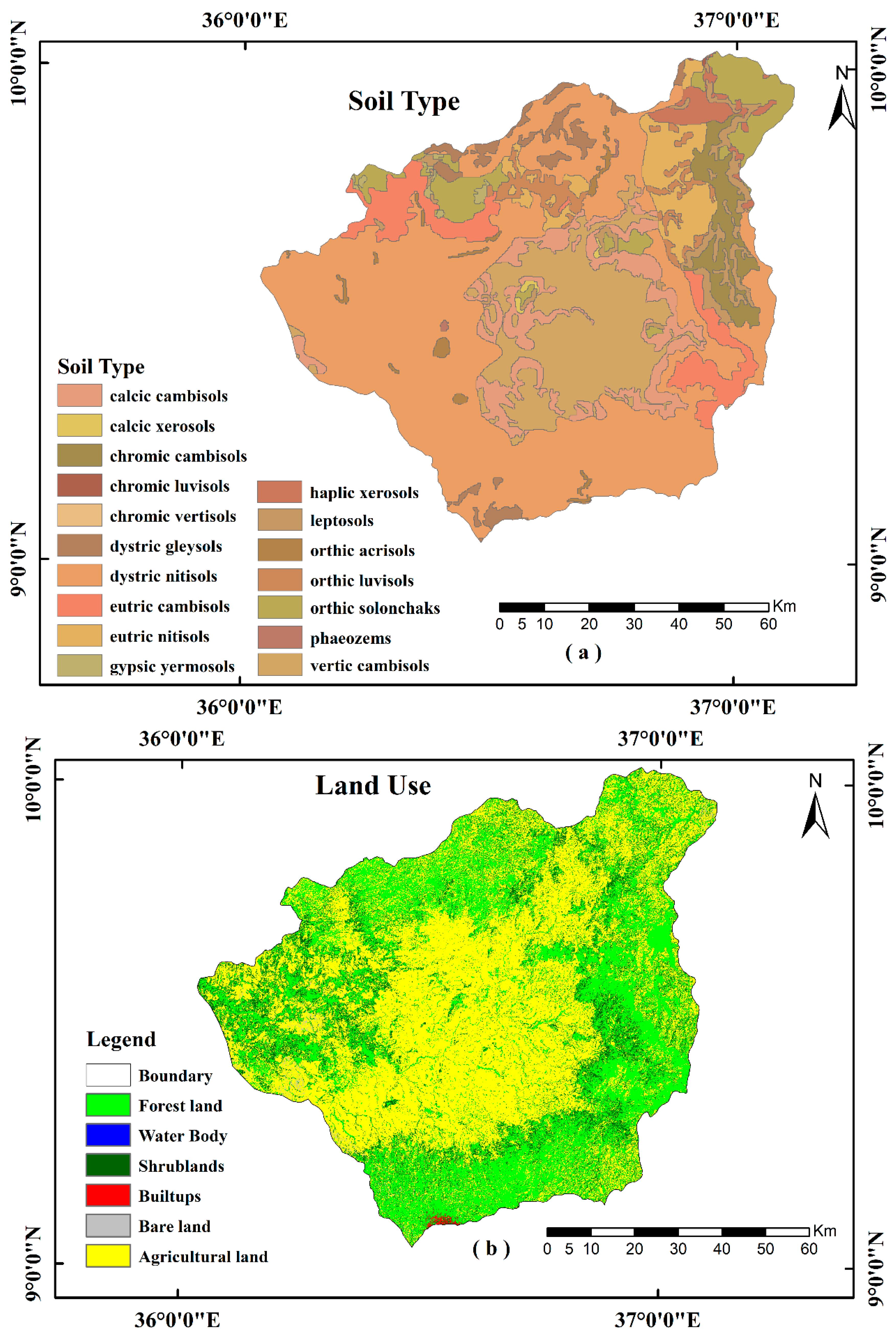
2.1. Description of the Study Area

This study was carried out in the Ager River basin, which is located between a latitude of 9°35′00′′ N and a longitude of 36°2′00″ E in the west-central part of Ethiopia. The basin is one of the tributaries of the Abbay River basin (Figure 1) that ultimately contributes to the Blue Nile River. This Anger basin consists of two regional zones and covers seventeen rural villages, into which an area of approximately 7902 km2 drains. The elevation of the basin ranges from 860 to 3210 m above the mean sea level. Generally, the land-use coverage of the basin covered by agricultural production (52.5%), forestland (10%) and about 37.5 covers wetland and settlements (Figure 1).
The study area experiences a unimodal rainfall pattern with a rainy season from June to September. The annual rainfall of the area is between 1280 mm and 2030 mm. The annual maximum temperature of the Anger basin ranges from 20 °C to 32 °C. While the yearly minimum temperature (June to September) of the basin ranges from 6 °C to 17 °C, its maximum temperature (January to March) ranges from 29 °C to 32 °C [36]. The annual potential evapotranspiration (PET) of the basin is generally between 1360 mm and 1925. The highest PET is observed in the low land areas of the Anger basin with an annual value of ≥1800 mm/year; however, the annual PET drops to 1600 mm/year in the highlands of the basin.

2.2. Land Suitability Assessment
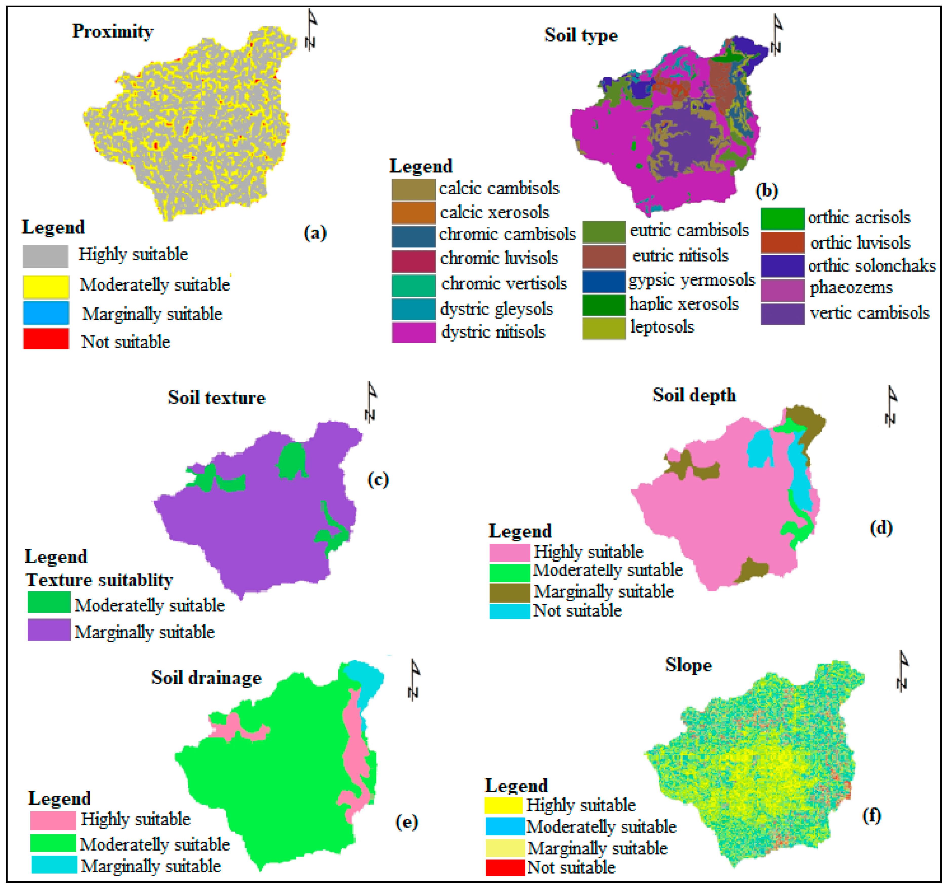
The suitability of land is used to identify the irrigation productivity of an area [31,37,38,39]. The factors affecting the land suitability of the study area were determined using a survey and consulting the literature. Then, the major factors that affect agricultural land suitability were mapped using the Geographic Information System (GIS) Tools. According to the FAO framework, land suitability for irrigation is classified into four classes [37,40]. These classes range from highly suitable (Class S1) to less suitable (Class S4). In this study, the land suitability assessment is based on four individual suitability factors: land use, slope, soil type, and available water source [41,42,43]. These suitability factors were derived using the spatial analysis tool in Arc GIS. The data availability and factors considered as inputs for the tool are detailed in Kalogirou [38] and summarized in Table 1.

2.2.1. Soil Factor

Soil is a key factor for determining the suitability of an area for both agriculture and irrigation. The soil map for the study area is presented in Figure 2a and summarized in Table 1. The soil data set was developed by Africa Soil Information System (AfSIS) to bridge the gap of soil information. AfSIS collected soil samples from more than 28,000 locations throughout 40 African countries [44]. This study also used relevant secondary information for the preparation of soil maps at the administrative level. Spatial information about each soil at an administrative scale was obtained from the geomorphology map of Ethiopia [45] at a scale of 1:1,000,000 and from a topographic map of 1:50,000 obtained from the Ethiopian Mapping Authority. The AfSIS soil data had 250 m by 250 m resolutions with six layers (i.e., 0–5 cm, 5–15 cm, 15–30 cm, 30–60 cm, 60–100 cm, and 100–200 cm). Each soil layer contains the soil texture, organic carbon content, bulk density, drainage class, and fertility status (soil pH and organic matter). A total of 46 samples were characterized across the seventeen villages of the Anger basin. For each soil sample collected, the physicochemical properties were analyzed in the laboratory using the standard guidelines for soil profile descriptions [46,47]. This was performed at the Haramaya University’s Soil Chemistry and Physics laboratories. For the analysis, the soil samples were air-dried and crushed with mortar to allow them to pass through a 2 mm diameter sieve. The soil physicochemical properties were used as input data for land suitability evaluation and classification.
The soil texture values of the six layers, representing the maximum root depth of the major crops grown in the area, were aggregated using a weighted average approach. The soil texture was classified into representative classes using the USDA soil texture classification method [48,49,50]. Soil depth refers to the thickness of the soil materials that provide structural support, nutrients, and water for plants. The depth to the next soil layer can also affect irrigation management decisions. Accordingly, a shallow soil depth reduces the plant rooting depth and available soil water for plants. The soil depth of the study area considerably varies across the different topographic positions. For example, soils on the steep slopes and in the drier parts of the Anger basin are generally shallow and/or stony. This suggests that such soils may not store adequate water and nutrients for sustainable crop production. In the sample characterized, the root depth varied from 58 to 240 cm. Deeper soils can store sufficient moisture and nutrients for crop production. As a result of this, most agricultural activities are concentrated in areas where such deep soils persist.

2.2.2. Climate

The climate factors of the study area, such as PET and long term rainfall data, can be used to estimate future changes in the climate [15,50]. Daily rainfall data of the study area were gathered from the Ethiopian Metrological Agency (EMA), and the PET data were obtained from MODIS global evapotranspiration. Two major agro-ecological zones were classified for the study basin based on the altitude, soil moisture, and physiographical characteristics of the area. These agroecological zones include low lands locally called “Kolla”. Kolla mainly exists at an altitude of 500 to 1500 m.a.s.l and are relatively drier and warmer. The second zone is locally known as “Woina Dega”, which are areas with an altitude of 1500 to 2400 m.a.s.l that feature relatively colder and wetter climate conditions. The evapotranspiration rate can be affected by changes in temperature, which has a direct relationship to the PET [51]. The future annual PET was computed using the Hargreaves–Samani method [52]. The annual temperature in the basin varies from 6 to 32 °C. The long-term changes in historical temperature and PET data were used to predict future climate change in the basin using the station data and based on GIS-tools application.

2.2.3. Land Use

The land use data for this study were collected from the Ethiopian Ministry of Water and Energy (MOWEI), global Landsat, and satellite image classifications with a 30 m resolution. The Landsat 8 satellite images of the basin were downloaded from http://glovis.usgs.gov/ or http://earthexplorer.usgs.gov/ and used for the classification (Figure 2b). The land use was grouped using a 30 m spatial resolution. Followed by the image enhancement, rectification, and classification were also applied to the raw images. The land cover conditions for the two different periods were spatially compared (1985 to 2000 and 2000 to 2014). Then, the rate and quantity of change were calculated. Image classification was only used for the extraction of distinct classes or land use/land cover categories from satellite imagery. A ground survey was used to cross-check some of the features identified from the satellite imagery. The land use data were used to ascertain the potential of suitable land for irrigated agriculture. Woodlands and forests dominate the Anger basin, which is about 40% coverage of the area. Other land-use types include pastoral, bare, shrub, and cultivated lands. The land use data show that agricultural land comprises the largest proportion of the basin (58%), followed by bare land (27%) and shrublands (14%). The remaining land use areas were grouped as water bodies and built-up areas.

2.2.4. Slope Factor

The suitability of an irrigation area can be affected by the slope of the land, which plays a major role in irrigation efficiency and land preparation for surface water irrigated agriculture [38]. The Anger basin has an undulating topography that ranges from 860 to 3210 m above mean sea level (m.a.s.l) with a considerably varied slope. The slope of the study area was estimated using 30 m resolution Digital Elevation Model (DEM) data obtained from the Shuttle Radar Topography Mission (SRTM). A 30 m resolution DEM is freely available at http://earthexplorer.usgs.gov/. The slope factor was processed on a pixel-by-pixel basis using the slope calculated from the DEM. The results of the Anger basin indicate that about 65% of the area has a slope of 0 to 3%. The majority of this range is below 2%, which is considered suitable for surface irrigation systems (Figure 3a). Overall, the average slope of the basin is considered moderately appropriate for surface irrigated agriculture.

2.2.5. Water Source Factor

The distance from perennial rivers determines the suitability class of a land parcel, which is a plot of land used for irrigation based on land access and river proximity. Figure 3b shows the distance from the water source to the land parcel. The distances were calculated by projecting the locations to a Mercator (UTM) Zone 37 N. The distance map was categorized into four classes based on previous studies [53,54]. In this study, the farthest distances were categorized as class S4 (>4000 m), while the closest distances were classified as S1 (<200 m), which is highly suitable. Class S2 (2000–3000 m) and S3 (3000–4000 m) are classified as a moderate and marginally suitable distance, respectively. The surface and groundwater potentials of the basin were obtained from the Ethiopian Ministry of Water Resources. Additional data include a survey on the potential of groundwater yield, storage, and groundwater depth for further information on low flow conditions for the application of irrigation.

2.3. Irrigation Optimization

The Multi-Criteria Decision Analysis (MCDA) approach was also utilized in this study. This approach provides a procedure for structuring decision problems by designing, evaluating, and prioritizing alternative decisions (Figure 4). MCDA also supports complex decision making when multiple, conflicting factors are involved during the decision-making process. We used a GIS processing tool combined with geospatial data and value judgments to obtain information for decision making. The MCDA approach aids decision making at any stage of the decision making processes, such as design, choice, and visualization [41,55]. The GIS-based Multi-Criteria Evaluation (MCE) was used for the identification of potentially suitable land areas for irrigated agriculture. MCE is a fully continuous variable that contains factors and expresses the varying degree of suitability for the decision under consideration. A combination of numerous criteria to a single indexed output of MCE was implemented in a GIS environment. The process for converting data to such numeric scales is called standardization [56]. Standardized factors were used to produce weighted linear combinations, and each factor was multiplied by weight according to the relative importance of each factor to summarize the results. Hence, the characteristics of the weighted value fit to the class of each factor and range between the intervals 0–1 such as distance to water body weighted 0.216 and slope weighted to 0.12. The obtained data, such as soil, land use, evapotranspiration, and elevation were then formatted in a grid. The rainfall and potential groundwater yield data were obtained from the Ethiopian Agricultural Transformation Agency (ATA) [2,57]. The factors affecting land suitability and irrigation optimization were analyzed using MCDA, whereby the factors were reclassified, weighted, and overlaid to identify the areas most suitable for surface irrigated agriculture. The land suitability analysis framework is presented in Figure 4.

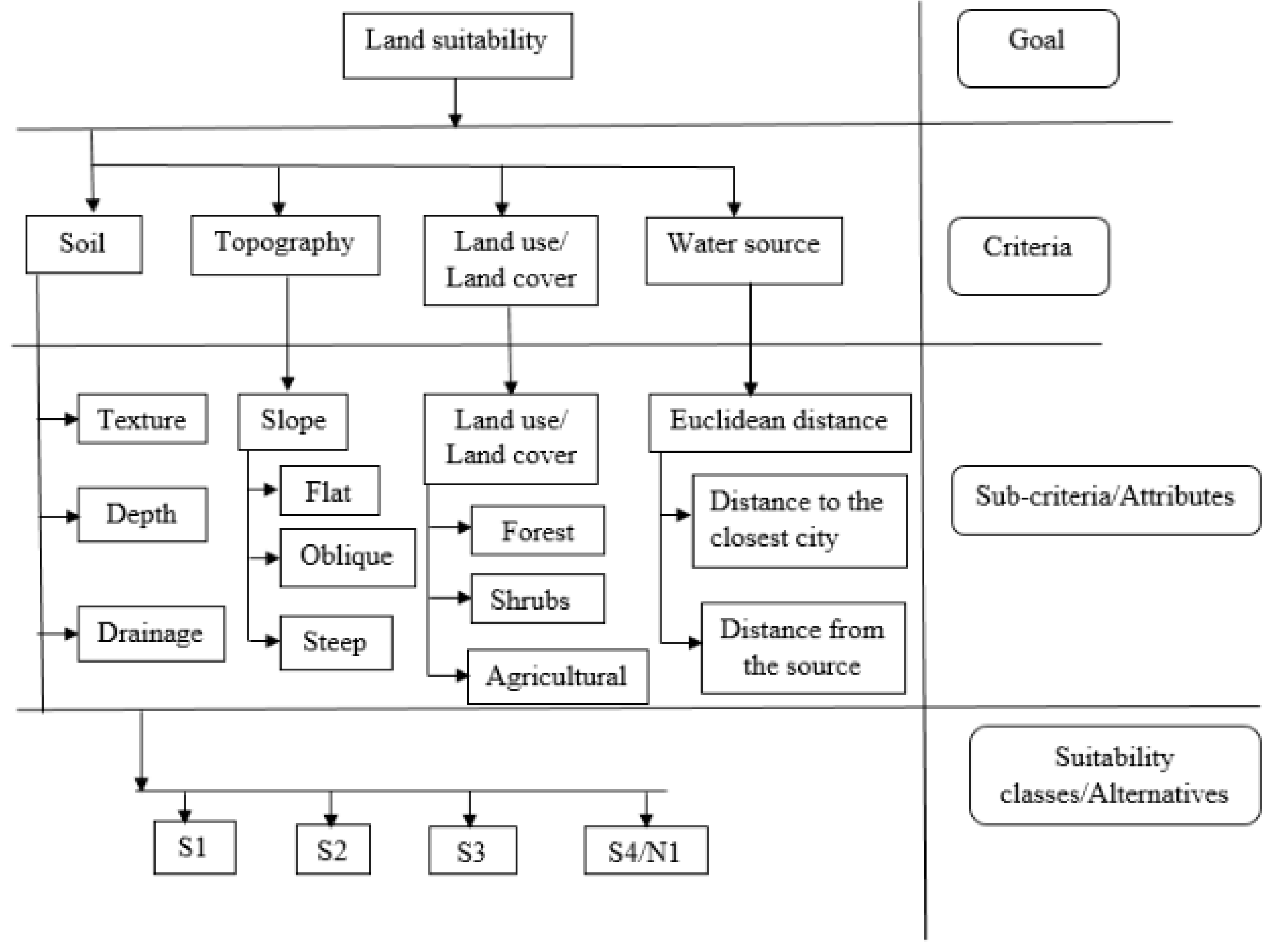
2.4. Multi-Criteria Evaluation

The Multi-Criteria Evaluation (MCE) using the spatial Analytical Hierarchy Process (AHP) approach allows one to use a range of different criteria for evaluations [58]. This method facilitates the use of multiple water resource development and management scenarios, especially in ranking the remainders in terms of water resource development impacts (Figure 5). The AHP procedure was applied for criteria, sub-criteria, and suitability class analyses [59]. The relationship between objectives and their attributes has a hierarchical structure [55]. At the highest level, one can distinguish the objectives, and at a lower level, the attributes can be decomposed.

2.5. Suitability Mapping and Preliminary Land Suitability for Irrigation

A suitability model was created using a model builder in the Arc GIS toolbox. The consistency ratio was used, and the pair-wise matrix consistency was evaluated to increase the reliability. Then, the suitability of the land for irrigation was determined. An equal interval technique for weighing factors was spread to the levels of different suitability classes [62]. The reclassified datasets were combined to find the most suitable location. Mapping of the preliminary suitability of the irrigated land was computed using the weighted overlay analysis function of the ArcGIS spatial analysis tool.

Land Suitability and Climate Change

The rainfall deficit and slope of the land are the most critical factors for determining irrigation suitability. The land use, soil properties, water resources, and topography of the area were evaluated to determine the suitability of the land with respect to climate change. The impacts of climate change on land suitability for irrigated agriculture were determined. A comparison of the potential evapotranspiration (PET) and rainfall in the area indicates that the proportion of rainfall is higher than PET during the rainy season [63]. Hence, the average historical PET and precipitation value considered for the year 2050 based on the International Panel on Climate Change (IPCC) model and seasonal differences [64]. Various inter-related factors dominate the climate in the study region, but the main factors are the area’s near-equatorial location and altitude. The year is divided into three seasons: a primary rainy season (Kiremt) from July to mid-September, a dry season (Bega) from October to February, and a “small rainy” season (Belg) in March and April. The small amount of rain in the latter season originates from the Indian Ocean and is brought by Northwest winds, while the heavy rains in the wet season come from the Atlantic Ocean with north-east winds. Agricultural production in the sub-basin is highly exposed to climate change, as farming activities directly depend on climatic conditions.

2.6. Survey and Historical Irrigation Data

A survey was conducted using a semi-structured questionnaire involving about 340 households (HH), of which 20 households were located in each of the seventeen villages. The households were sampled based on purposive sampling [59,60,61]. The questionnaire took about one and a half hours for each household. In addition, secondary data were collected from the Ethiopian Ministry of Water Resources, Irrigation, and Agricultural Offices [21]. Further, focus group discussions were undertaken for three hours, which involved critical informants from each village using the local language while considering the opinion of the respondents. All data collection processes were performed for two months (Supplementary Materials).

2.7. Weighing Land Suitability Factors

The identification technique for the land suitability factors was weighted using pairwise comparison. The comparison technique was used to identify the vital matrix for comparison. The weighting factors were compared one-on-one using a comparison matrix and assigned to each element based on the factor’s relative importance. The consistency ratio was employed to evaluate the pair-wise consistency comparison [65]. The highest value corresponds to absolute importance, and the lowest value indicates the reciprocal in the comparison matrix. The normalized eigenvector of the factors was used to compute the weighting factors through the cumulative sum [22,66]. A preliminary map of land suitability was collected and finally overlaid using the weighted factor overlay tool of the Arc GIS spatial analysis tool. Equal interval range techniques were distributed from the suitability classes to the overall weights of the factor. Moreover, the land-characteristic suitability is based on slope, land use, and soil type. The slope map was computed from a 20 m resolution DEM and was divided into four suitability classes for surface irrigation suitability assessment [37,67]. The potential irrigation areas and land suitability were analyzed using Arc GIS integrated with multi-criteria analyses. These criteria reflect the key focus of the scenarios and methods for measuring the consequences. The criteria measured using “indicators” cover a wide range of different thematic areas that are measurable.

2.8. Preliminary Suitability Mapping and Creating a Toolbox Model

A toolbox (suitability analysis toolbox, tbx) was initially created to design the model, after which the model was created to perform the spatial analysis tasks. The model was built by stringing tools together in the model builder using Arc GIS. The collected data were classified into two different formats to analyze the preliminary suitability (a vector format and grid format). Suitability mapping was followed by reclassifying the factors summarized in Figure 5. Agricultural land suitability was classified into four levels according to the FAO framework [40,65]. We used the FAO land use classification framework (Table 2) of highly suitable (S1), moderately suitable (S2), marginally suitable (S3), and not suitable (S4).

2.9. Land Suitability Based on Proximity to River and Slope

The appropriateness of land for development was analyzed using factor determining the suitability of the land for irrigation. Following this, the vicinity to river classified into four classes, such as highly suitable (0–256 m), moderately suitable (257–953 m), marginally suitable (954–1100 m), and not suitable/Currently not suitable (1101–1537 m). The results are presented in Table 3. The land-characteristic suitability based on slope classified into four classes, such as class S1 (0%–10%), class S2 (5%–8%), class S3 (8%–15%) and class N (>15%).

3. Results and Discussion

3.1. Suitability of the Land for Irrigation Versus Climate Change

The survey results suggest that irrigation has greater importance during the dry season than during the rainy season (Supplementary Materials). Supplementary irrigation is needed under such conditions. Further analysis indicates that the average daily PET of the area from MODIS global evapotranspiration (ET) ranges between 7 and 10 mm/day during the crop growing season [65,66]. Moreover, the PET in the basin ranges between 113.3 to 160.4 mm monthly. The mean monthly rainfall during the same period varies from 12.3 mm in December to 134.7 mm in August. In the lowland areas, characterized by high temperatures, the PET is higher than 1800 mm/year. The PET and rainfall results also indicate the importance of applying irrigation to compensate for the water deficit during the crop growing season.

3.1.1. Proximity to River

The proximity to the river for the suitability classification was divided into four groups based on a map of river proximity (Figure 6a). Each suitability class and percentage of proximity to the river are presented in Table 3. The findings indicate that more than 71% of the basin is highly suitable, with about 19% of the basin’s area being moderately ideal for surface irrigation purposes (Table 3).

3.1.2. Soil Suitability Class

The soil texture of the Anger basin was divided into two (moderately and marginally suitable). The soil suitability classes were determined based on the soil textural classes of the study area (Table 4). The land suitability classes were determined based on soil depth (Table 5) and soil drainage suitability (Table 6).
Approximately 90% of the basin’s soil texture is marginally suitable for irrigation (Table 4). While more than 77% of the basin’s soil depth is highly suitable for irrigation (Table 5), only about 11% of the area is highly suitable for drainage (Table 6). Therefore, the soil of the area is generally good for irrigated agriculture development.

3.1.3. Slope Suitability Class

The land suitability based on slope classes is presented in Figure 6f. About 3680 km2 (46%) of the Anger basin’s area is characterized with slopes ≤5%, which are classified as highly suitable for irrigation. Only about 3% of the river basin area (223 km2) with a slope value of >15% is less suitable for irrigation (Table 7). Overall, based on slope, more than 70% of the basin is classified as moderately to highly suitable for irrigation (Table 7). This means the irrigation potential of the land in the study area could be affected by other factors, such as soil drainage and climate change. The topography and soil condition of the study area also encourages high surface runoff. Thus, water conservation and harvesting systems are highly recommended. Hence, about half of the study area is generally ideal for surface irrigation systems.

3.1.4. Agricultural Land Suitability

The land suitability coverage of the Anger basin for surface irrigation was then identified (Table 8). The use of highly efficient irrigation systems (sprinklers and drips) are also encouraged in the basin as the finding indicates that the land is suitable for surface irrigation system (Table 8) and helps to optimize water productivity. Generally, about 40% of the area is highly to moderately suitable for surface water irrigation (Figure 7).

3.2. Impact of Climate Change on Land Suitability for Irrigated Agriculture

The data analysis and survey results indicate that the rainfall in the area is unreliable and that the temperature increased by 21% from the baseline period of 2007. This may cause water scarcity in agricultural production and thus reduce the potentially suitable surface irrigation areas of the basin. On the other hand, approximately 77% of the available water in the basin can be used to meet the communities’ domestic water demands. Only 12% of the available water is used for crop production. The undulating topography of the Anger River basin encourages high runoff, and the total precipitation received in the basin leaves the basin boundary with short residence time. There is a need to conserve and harvest the rainwater through different water harvesting structures to improve water availability in the basin. The survey results indicate that developed springs and hand-dug wells are the major sources of drinking water for the communities in the Anger river basin. From the secondary data collected, we found that 90% of families access drinking water from developed springs and hand-dug wells. In contrast, the remaining families mostly rely on other sources, such as shallow wells, deep wells, and motorized springs. Based on the reports of the basin water, minerals, and energy offices, more than 95% of the families in this basin are dependent on a river and a developed spring water source for their livestock drinking water. About 77% of the sources of water for domestic use comes from undeveloped springs. Most of the irrigated land in the basin depends upon traditional methods of irrigation, with very few crop varieties. Of the total irrigable land of the area, about 61,711.25 hectares of the land were cultivated using traditional irrigation. Such systems use water diverted from the river to irrigate farmland at the household level. About 2746 hectares of the land area was cultivated under small scale irrigation, which is practiced by farmers with support from the agricultural office (Supplementary Materials). This indicates the limited scope of irrigation supported agricultural activities within the basin. On the other hand, the land cover distribution and the survey results indicate that about 88% of the Anger basin’s community depends on agricultural activities, indicating the importance of having an expansive, enhanced surface irrigation system to improve the agricultural productivity of the basin and thus the livelihood of the communities.

4. Summary and Conclusions

This study assessed the irrigation suitability of the Anger River basin (Ethiopia) based on six irrigation suitability factors (distance to water resources or river, slope, land use/land cover, soil texture, drainage, and depth), including climate change impacts. Based on these multi-evaluation criteria and matrix, supported with GIS-tools application, the study successfully mapped the irrigation suitability and identified the potential irrigable areas of the basin for an optimized irrigation system [68].
It is concluded that approximately 40% of the basin’s area can provide moderately to highly suitable conditions for surface irrigation systems. However, it is expected that future climate change may reduce the available water resources of the basin due to increases in temperature and evapotranspiration rate, and thus decrease in the estimated potential irrigable areas of the basin. This indicates the importance of implementing climate change mitigation measures, including enhanced surface irrigation systems to optimize the use of available water resources and irrigation water efficiency and improve the agricultural crop productivity of the basin. Therefore, this study could provide useful information for future water resources development and irrigated agricultural land plans of the basin whereby more than 85% of the basin’s communities depend on agricultural crop productivity.

Supplementary Materials

The following are available online at https://www.mdpi.com/2225-1154/8/9/97/s1.

Author Contributions

M.D. conceptualized the research question and the concept of the paper. Together with M.O.D., O.T.L., and F.B.M., the design of the experiments, data generation, collection, analysis, modeling, interpretation, and final submission to the journal were achieved. All authors have read and agreed to the published version of the manuscript.

Funding

This research received no external funding.

Acknowledgments

The Haramaya University is acknowledged for providing support during fieldwork. Special thanks go to Afera Halefom and Inkosa Mengasha for their kind support during the field campaign and data collection. Chemeda Toli from the Nekemte Abbay Basin Authority, Ethiopia, is recognized for his support of the field works. Moreover, the University of Johannesburg is also warmly acknowledged for its kind support of this research.

Conflicts of Interest

The authors declare no conflict of interest.

References

  1. McNally, A.; Verdin, K.; Harrison, L.; Getirana, A.; Jacob, J.; Shukla, S.; Arsenault, K.; Peters-Lidard, C.; Verdin, J.P. Acute Water-Scarcity Monitoring for Africa. Water 2019, 11, 1968. [Google Scholar] [CrossRef] [Green Version]
  2. Pan, T.; Kuang, W.; Hamdi, R.; Zhang, C.; Zhang, S.; Li, Z.; Chen, X. City-Level Comparison of Urban Land-Cover Configurations from 2000–2015 across 65 Countries within the Global Belt and Road. Remote Sens. 2019, 11, 1515. [Google Scholar] [CrossRef] [Green Version]
  3. Strzepek, K.M.; McCluskey, A. The Impacts of Climate Change on Regional Water Resources and Agriculture in Africa; World Bank Publications: Washington, DC, USA, 2007; Volume 4290. [Google Scholar]
  4. Elliott, J.; Deryng, D.; Müller, C.; Frieler, K.; Konzmann, M.; Gerten, D.; Glotter, M.; Flörke, M.; Wada, Y.; Best, N. Constraints and potentials of future irrigation water availability on agricultural production under climate change. Proc. Natl. Acad. Sci. USA 2014, 111, 3239–3244. [Google Scholar] [CrossRef] [Green Version]
  5. Farjad, B.; Pooyandeh, M.; Gupta, A.; Motamedi, M.; Marceau, D. Modelling Interactions between Land Use, Climate, and Hydrology along with Stakeholders’ Negotiation for Water Resources Management. Sustainability 2017, 9, 2022. [Google Scholar] [CrossRef] [Green Version]
  6. Rossi, G. Drought mitigation measures: A comprehensive framework. In Drought and Drought Mitigation in Europe; Springer: Berlin, Germany, 2000; pp. 233–246. [Google Scholar]
  7. Tonini, A.; Michalek, J.; Fellmann, T.; M’barek, R.; Delincé, J.; Philippidis, G.; Bukowski, M.; Conforti, P.; Dixon, P.; Gohin, A. Simulating Long-Term Effects of Policies in the Agri-Food Sector: Requirements, Challenges and Recommendations; Publications Office of the European Union: Luxembourg, 2013. [Google Scholar]
  8. Shiferaw, D.; Suryabhagavan, K. Forest degradation monitoring and assessment of biomass in Harenna Buluk District, Bale Zone, Ethiopia: A geospatial perspective. Trop. Ecol. 2019, 60, 94–104. [Google Scholar] [CrossRef]
  9. Riebsame, W.E.; Changnon, S.A., Jr.; Karl, T.R. Drought and Natural Resources Management in the United States. Impacts and Implications of the 1987–89 Drought; Westview Press Inc.: Boulder, CO, USA, 1991. [Google Scholar]
  10. Pereira, L.S.; Oweis, T.; Zairi, A. Irrigation management under water scarcity. Agric. Water Manag. 2002, 57, 175–206. [Google Scholar] [CrossRef]
  11. Mishra, A.K.; Singh, V.P. A review of drought concepts. J. Hydrol. 2010, 391, 202–216. [Google Scholar] [CrossRef]
  12. Fischer, G.; Tubiello, F.N.; Van Velthuizen, H.; Wiberg, D.A. Climate change impacts on irrigation water requirements: Effects of mitigation, 1990–2080. Technol. Forecast. Soc. Change 2007, 74, 1083–1107. [Google Scholar] [CrossRef] [Green Version]
  13. Archer, D.R.; Forsythe, N.; Fowler, H.J.; Shah, S.M. Sustainability of water resources management in the Indus Basin under changing climatic and socio economic conditions. Hydrol. Earth Syst. Sci. 2010, 14, 1669–1680. [Google Scholar] [CrossRef] [Green Version]
  14. Alemayehu, T.; McCartney, M.; Kebede, S. The water resource implications of planned development in the Lake Tana catchment, Ethiopia. Ecohydrol. Hydrobiol. 2010, 10, 211–221. [Google Scholar] [CrossRef]
  15. Rosenzweig, C.; Parry, M.L. Potential impact of climate change on world food supply. Nature 1994, 367, 133. [Google Scholar] [CrossRef]
  16. Awulachew, S.B.; Yilma, A.D.; Loulseged, M.; Loiskandl, W.; Ayana, M.; Alamirew, T. Water Resources and Irrigation Development in Ethiopia; Iwmi: Colombo, Sri Lanka, 2007; Volume 123. [Google Scholar]
  17. Dawit, M.; Halefom, A.; Teshome, A.; Sisay, E.; Shewayirga, B.; Dananto, M. Changes and variability of precipitation and temperature in the Guna Tana watershed, Upper Blue Nile Basin, Ethiopia. Modeling Earth Syst. Environ. 2019. [Google Scholar] [CrossRef]
  18. Belete, M.A. Modeling and Analysis of Lake Tana Sub Basin Water Resources Systems, Ethiopia. Ph.D. Thesis, Universität Rostock, Rostock, Germany, 2014. [Google Scholar]
  19. MoWIE, F. Federal Democratic Republic of Ethiopia Ministry of Water, Irrigation and Electricity: Arjo Dhidhessa Dam and Appurtenant Structures Final Design Modification Report; OWWDSE/SES LLC, USA/Synergics Hydro (India) Pvt. Ltd.: Addis Ababa, Ethiopia, 2017. [Google Scholar]
  20. Kidanemaraim, J. Participatory integrated water resources management (IWRM) planning: Lessons from Berki Catchment, Ethiopia. In Proceedings of the Water, Sanitation and Hygiene: Sustainable Development and Multisectoral Approaches, The 34th WEDC International Conference, United Nations Conference Centre, Addis Ababa, Ethiopia, 18–22 May 2009; pp. 326–333. [Google Scholar]
  21. Conway, D. The impacts of climate variability and future climate change in the Nile Basin on water resources in Egypt. Int. J. Water Resour. Dev. 1996, 12, 277–296. [Google Scholar] [CrossRef]
  22. Worqlul, A.W.; Jeong, J.; Dile, Y.T.; Osorio, J.; Schmitter, P.; Gerik, T.; Srinivasan, R.; Clark, N. Assessing potential land suitable for surface irrigation using groundwater in Ethiopia. Appl. Geogr. 2017, 85, 1–13. [Google Scholar] [CrossRef]
  23. Hagos, F.; Makombe, G.; Namara, R.E.; Awulachew, S.B. Importance of Irrigated Agriculture to the Ethiopian Economy: Capturing the Direct Net Benefits of Irrigation; IWMI: Colombo, Sri Lanka, 2009; Volume 128. [Google Scholar]
  24. Awulachew, S.B.; Ahmed, A.; Haileselassie, A.; Yilma, A.D.; Bashar, K.; McCartney, M.P.; Steenhuis, T. Improved Water and Land Management in the Ethiopian Highlands and Its Impact on Downstream Stakeholders Dependent on the Blue Nile; IRLI: Addis Ababa, Ethiopia; Nairobi, Kenya, 2010. [Google Scholar]
  25. Mekuria, W. The link between agricultural production and population dynamics in Ethiopia: A review. Adv. Plants Agric. Res. 2018, 8, 348–353. [Google Scholar] [CrossRef]
  26. Hurni, H.; Tato, K.; Zeleke, G. The implications of changes in population, land use, and land management for surface runoff in the upper Nile basin area of Ethiopia. Mt. Res. Dev. 2005, 25, 147–154. [Google Scholar] [CrossRef] [Green Version]
  27. Awulachew, S.B.; Erkossa, T.; Namara, R. Irrigation Potential in Ethiopia: Constraints and Opportunities for Enhancing the System; Bill and Melinda Gates Foundation: Seattle, WA, USA, 2010. [Google Scholar]
  28. Meze-Hausken, E. Contrasting climate variability and meteorological drought with perceived drought and climate change in northern Ethiopia. Clim. Res. 2004, 27, 19–31. [Google Scholar] [CrossRef] [Green Version]
  29. De Brucker, K.; Macharis, C.; Verbeke, A. Multi-criteria analysis and the resolution of sustainable development dilemmas: A stakeholder management approach. Eur. J. Oper. Res. 2013, 224, 122–131. [Google Scholar] [CrossRef]
  30. Yilmaz, B.a.H.; Harmancioglu, N. Multi-criteria decision making for water resource management: A case study of the Gediz River Basin, Turkey. Water SA 2010, 36, 1–14. [Google Scholar] [CrossRef] [Green Version]
  31. Feizizadeh, B.; Blaschke, T. Land suitability analysis for Tabriz County, Iran: A multi-criteria evaluation approach using GIS. J. Environ. Plan. Manag. 2013, 56, 1–23. [Google Scholar] [CrossRef]
  32. Aldababseh, A.; Temimi, M.; Maghelal, P.; Branch, O.; Wulfmeyer, V. Multi-criteria evaluation of irrigated agriculture suitability to achieve food security in an arid environment. Sustainability 2018, 10, 803. [Google Scholar] [CrossRef] [Green Version]
  33. Alwan, I.A.; Karim HHAziz, N.A. Groundwater aquifer suitability for irrigation purposes using multi-Criteria decision approach in Salah Al-Din Governorate/Iraq. AgriEngineering 2019. [Google Scholar] [CrossRef] [Green Version]
  34. Bertoldi, G.; Notarnicola, C.; Leitinger, G.; Endrizzi, S.; Zebisch, M.; Della Chiesa, S.; Tappeiner, U. Topographical and ecohydrological controls on land surface temperature in an alpine catchment. Ecohydrol. Ecosyst. Land Water Process. Interact. Ecohydrogeomorphol. 2010, 3, 189–204. [Google Scholar] [CrossRef]
  35. Verburg, P.H.; Neumann, K.; Nol, L. Challenges in using land use and land cover data for global change studies. Glob. Chang. Biol. 2011, 17, 974–989. [Google Scholar] [CrossRef] [Green Version]
  36. Ethiopian, Environmental Protection. Ecologically Sustainable Industrial Development Project: Guideline Ambient Environmental Standards for Ethiopia; Prepared by the Environmental Protection Authority of Ethiopia in Collaboration with UNIDO; Environmental Protection Authority of Ethiopia: Addis Ababa, Ethiopia, 2003; pp. 10–28. [Google Scholar]
  37. FAO; UNEP. The Future of our Land—Facing the Challenge, Guidelines for Integrated Planning for Sustainable Management of Land Resources; UNEP: Nairobi, Kenya; FAO: Rome, Italy, 1999. [Google Scholar]
  38. Kalogirou, S. Expert systems and GIS: An application of land suitability evaluation. Comput. Environ. Urban Syst. 2002, 26, 89–112. [Google Scholar] [CrossRef]
  39. Ajami, H.; McCabe, M.F.; Evans, J.P.; Stisen, S. Assessing the impact of model spin-up on surface water-groundwater interactions using an integrated hydrologic model. Water Resour. Res. 2014, 50, 2636–2656. [Google Scholar] [CrossRef] [Green Version]
  40. Verheye, W.; Koohafkan, A.; Nachtergaele, F. The FAO guidelines for land evaluation. Encycl. Land Use Land Cover Soil Sci. Land Eval. 2009, 2, 78–100. [Google Scholar]
  41. Mendas, A.; Delali, A. Integration of MultiCriteria Decision Analysis in GIS to develop land suitability for agriculture: Application to durum wheat cultivation in the region of Mleta in Algeria. Comput. Electron. Agric. 2012, 83, 117–126. [Google Scholar] [CrossRef]
  42. Akıncı, H.; Özalp, A.Y.; Turgut, B. Agricultural land use suitability analysis using GIS and AHP technique. Comput. Electron. Agric. 2013, 97, 71–82. [Google Scholar] [CrossRef]
  43. Worqlul, A.W.; Collick, A.S.; Rossiter, D.G.; Langan, S.; Steenhuis, T.S. Assessment of surface water irrigation potential in the Ethiopian highlands: The Lake Tana Basin. Catena 2015, 129, 76–85. [Google Scholar] [CrossRef]
  44. Hengl, T.; Heuvelink, G.B.; Kempen, B.; Leenaars, J.G.; Walsh, M.G.; Shepherd, K.D.; Sila, A.; MacMillan, R.A.; de Jesus, J.M.; Tamene, L. Mapping soil properties of Africa at 250 m resolution: Random forests significantly improve current predictions. PLoS ONE 2015, 10, e0125814. [Google Scholar] [CrossRef] [PubMed]
  45. FAO. Assistance to Land Use Planning, Ethiopia: Geomorphology and Soils; Food and Agriculture Organization, FAO: Rome, Italy, 1984. [Google Scholar]
  46. FAO. Guidelines for Soil Description; FAO: Rome, Italy, 1990. [Google Scholar]
  47. Jahn, R.; Blume, H.; Asio, V.; Spaargaren, O.; Schad, P. Guidelines for Soil Description; FAO: Rome, Italy, 2006. [Google Scholar]
  48. SCS, USDA. SCS National Engineering Handbook, Section 4: Hydrology; USDA: Washington, DC, USA, 1972. [Google Scholar]
  49. Zhang, B.; Song, X.; Zhang, Y.; Han, D.; Tang, C.; Yu, Y.; Ma, Y. Hydrochemical characteristics and water quality assessment of surface water and groundwater in Songnen plain, Northeast China. Water Res. 2012, 46, 2737–2748. [Google Scholar] [CrossRef] [PubMed]
  50. Srivastava, A.K.; Mboh, C.M.; Zhao, G.; Gaiser, T.; Ewert, F. Climate change impact under alternate realizations of climate scenarios on maize yield and biomass in Ghana. Agric. Syst. 2018, 159, 157–174. [Google Scholar] [CrossRef]
  51. Watts, G.; Battarbee, R.W.; Bloomfield, J.P.; Crossman, J.; Daccache, A.; Durance, I.; Elliott, J.A.; Garner, G.; Hannaford, J.; Hannah, D.M.; et al. Climate change and water in the UK—Past changes and future prospects. Prog. Phys. Geogr. 2015, 39, 6–28. [Google Scholar] [CrossRef]
  52. Hargreaves, G.H.; Samani, Z.A. Reference crop evapotranspiration from temperature. Appl. Eng. Agric. 1985, 1, 96–99. [Google Scholar] [CrossRef]
  53. Soil Resources, Management and Conservation Service; FAO Land and Water Development Division. Agro-Ecological Zoning: Guidelines; Food & Agriculture Organization: Rome, Italy, 1996. [Google Scholar]
  54. FAO. A Framework for Land Evaluation; FAO Soils Bulletin 32; FAO and Agriculture Organization of the United Nations: Rome, Italy, 1976. [Google Scholar]
  55. Malczewski, J. GIS-based multicriteria decision analysis: A survey of the literature. Int. J. Geogr. Inf. Sci. 2006, 20, 703–726. [Google Scholar] [CrossRef]
  56. Voogd, J.H. Multicriteria Evaluation for Urban and Regional Planning; Pion Ltd.: London, UK, 1982. [Google Scholar]
  57. Oliphant, A.J.; Thenkabail, P.S.; Teluguntla, P.; Xiong, J.; Gumma, M.K.; Congalton, R.G.; Yadav, K. Mapping cropland extent of Southeast and Northeast Asia using multi-year time-series Landsat 30-m data using a random forest classifier on the Google Earth Engine Cloud. Int. J. Appl. Earth Obs. Geoinf. 2019, 81, 110–124. [Google Scholar] [CrossRef]
  58. Steuer, R.E.; Na, P. Multiple criteria decision making combined with finance: A categorized bibliographic study. Eur. J. Oper. Res. 2003, 150, 496–515. [Google Scholar] [CrossRef]
  59. Saaty, T.L. Decision making with the analytic hierarchy process. Int. J. Serv. Sci. 2008, 1, 83–98. [Google Scholar] [CrossRef] [Green Version]
  60. Mustafa, A.; Singh, M.; Sahoo, R.; Ahmed, N.; Khanna, M.; Sarangi, A.; Mishra, A. Land suitability analysis for different crops: A multi criteria decision making approach using remote sensing and GIS. Researcher 2011, 3, 61–84. [Google Scholar]
  61. Elaalem, M.; Comber, A.; Fisher, P. A comparison of fuzzy AHP and ideal point methods for evaluating land suitability. Trans. GIS 2011, 15, 329–346. [Google Scholar] [CrossRef]
  62. You, L.; Ringler, C.; Wood-Sichra, U.; Robertson, R.; Wood, S.; Zhu, T.; Nelson, G.; Guo, Z.; Sun, Y. What is the irrigation potential for Africa? A combined biophysical and socioeconomic approach. Food Policy 2011, 36, 770–782. [Google Scholar] [CrossRef] [Green Version]
  63. Xu, C.Y.; Singh, V.P. Evaluation and generalization of temperature-based methods for calculating evaporation. Hydrol. Process. 2001, 15, 305–319. [Google Scholar] [CrossRef] [Green Version]
  64. Andersson, L.; Samuelsson, P.; Kjellstro¨ M., E. Assessment of climate change impact on water resources in the Pungwe river basin. Tellus A Dyn. Meteorol. Oceanogr. 2011, 63, 138–157. [Google Scholar] [CrossRef] [Green Version]
  65. Franek, J.; Kresta, A. Judgment scales and consistency measure in AHP. Procedia Econ. Financ. 2014, 12, 164–173. [Google Scholar] [CrossRef] [Green Version]
  66. Saaty, T.L.; Vargas, L.G. Prediction, Projection, and Forecasting: Applications of the Analytic Hierarchy Process in Economics, Finance, Politics, Games, and Sports; Kluwer Academic Pub: Dordrecht, The Netherlands; Norwell, MA, USA, 1991. [Google Scholar]
  67. Brouwer, C.; Prins, K.; Heibloem, M. Irrigation Water Management: Irrigation Scheduling; Training Manual; FAO: Rome, Italy, 1989; Volume 4. [Google Scholar]
  68. Ayehu, G.T.; Besufekad, S.A. Land suitability analysis for rice production: A GIS based multi-criteria decision approach. Am. J. Geogr. Inf. Syst. 2015, 4, 95–104. [Google Scholar]
Figure 1. Location of the study area.
Climate 08 00097 g001
Figure 2. Soil type (top a) and land use land cover (bottom b) of the study area.
Climate 08 00097 g002
Figure 3. Slope (a) and proximity to a water source (b).
Climate 08 00097 g003
Figure 4. Flow diagram method of land suitability and irrigation potential mapping.
Climate 08 00097 g004
Figure 5. Hierarchical organization of criteria [60,61].
Climate 08 00097 g005
Figure 6. Land suitability map of the Anger River basin, Ethiopia: (a) river proximity; (b) soil type; (c) soil texture; (d) soil depth; (e) soil drainage; (f) slope.
Climate 08 00097 g006
Figure 7. Agricultural land suitability of Anger Sub-basin.
Climate 08 00097 g007
Table 1. Summary of the data sources and factors for the land suitability analysis.
Data TypeSource of DataSpatial Resolution
Soil (depth, texture, and drainage) Africa Soil Information System (AfSIS);
Ethiopian Ministry of Water and Energy, Irrigation (MOWEI);
Digital Soil Map of the World;
Field Sampling.
250 m by 250 m
Land useEthiopian Ministry of Water, Energy and Irrigation (MOWEI);
From Landsat-8 Satellite Images (4th and 5th bands of Landsat 8 satellite images for Satellite Image Classification);
Freely Downloaded http://glovis.usgs.gov/ and/or http://earthexplorer.usgs.gov/.
30 m by 30 m for classified image
Topography (Slope) A 20 m Digital Elevation Model (DEM) of the Shuttle Radar Topography Mission (SRTM)20 m by 20 m
Distance to water sourcesRadar Topography Mission (SRTM)20 m by 20 m
Table 2. Classification of the land suitability framework of FAO.
ClassSuitabilityWeightsLand Description
S1Highly suitable4/4The land is excellent without significant limitations and does not require increased inputs or have reduced productivity.
S2Moderately suitable3/4The land is suitable with limitations that either reduce productivity or require increased inputs to sustain productivity compared with those needed on S1 land.
S3Marginally suitable2/4This land has severe limitations whose benefits are reduced and whose required inputs to sustain production need to be increased. The cost to increase productivity is only marginally justified.
S4 (N1)Currently not suitable1/4The land does not support the particular land use on a sustainable basis or the benefits do not justify the inputs.
Table 3. Land suitability based on proximity to the river.
SuitabilityDescriptionArea (km2)Percentage (%)
Class S1Highly suitable5653.7871.55
Class S2Moderately suitable1509.3619.10
Class S3Marginally suitable671.548.50
Class NNot suitable66.850.85
Table 4. Suitability classes based on soil texture.
TextureSuitabilityDescriptionArea (km2)Percentage (%)
Clay loamS2Moderately suitable767.829.72
ClayS3Marginally suitable7133.1990.28
Table 5. Suitability based on soil depth.
Soil DepthSuitabilityClassArea (km2)Percentage (%)
0–10Highly suitableS16138.87577.692
10–50Moderately suitableS2332.5114.208
50–100Marginally suitableS3764.3339.673
>100Not suitableN665.7908.426
Table 6. Land suitability based on drainage.
Soil DrainageDescriptionClassArea (km2)Percentage (%)
WellHighly suitableS1901.982411.415
ImperfectModerately suitableS2320.61444.058
PoorMarginally suitableS3764.3339.673
Table 7. Land suitability based on slope classes.
SuitabilityClassArea (km2)Percentage (%)
Highly SuitableS13680.07246.574
Moderately SuitableS22906.50236.784
Marginally SuitableS31090.98713.807
Not SuitableN223.9562.834
Table 8. Land suitability for surface irrigation in the Anger basin.
Land SuitabilityArea (km2)Percentage (%)
Highly suitable1616.47920.458
Moderately suitable1589.45620.116
Marginally suitable4564.31457.765
Not suitable131.2611.661

