Human–Environment Natural Disasters Interconnection in China: A Review


Abstract
1. Introduction
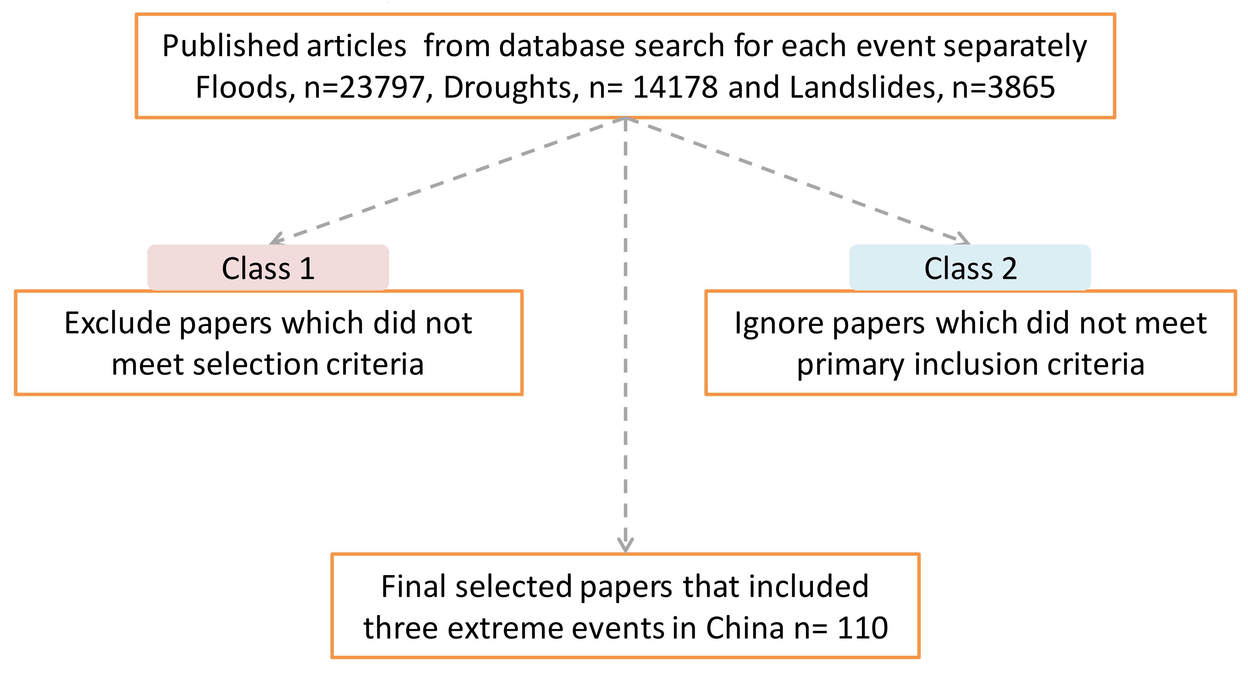
2. Materials and Methods
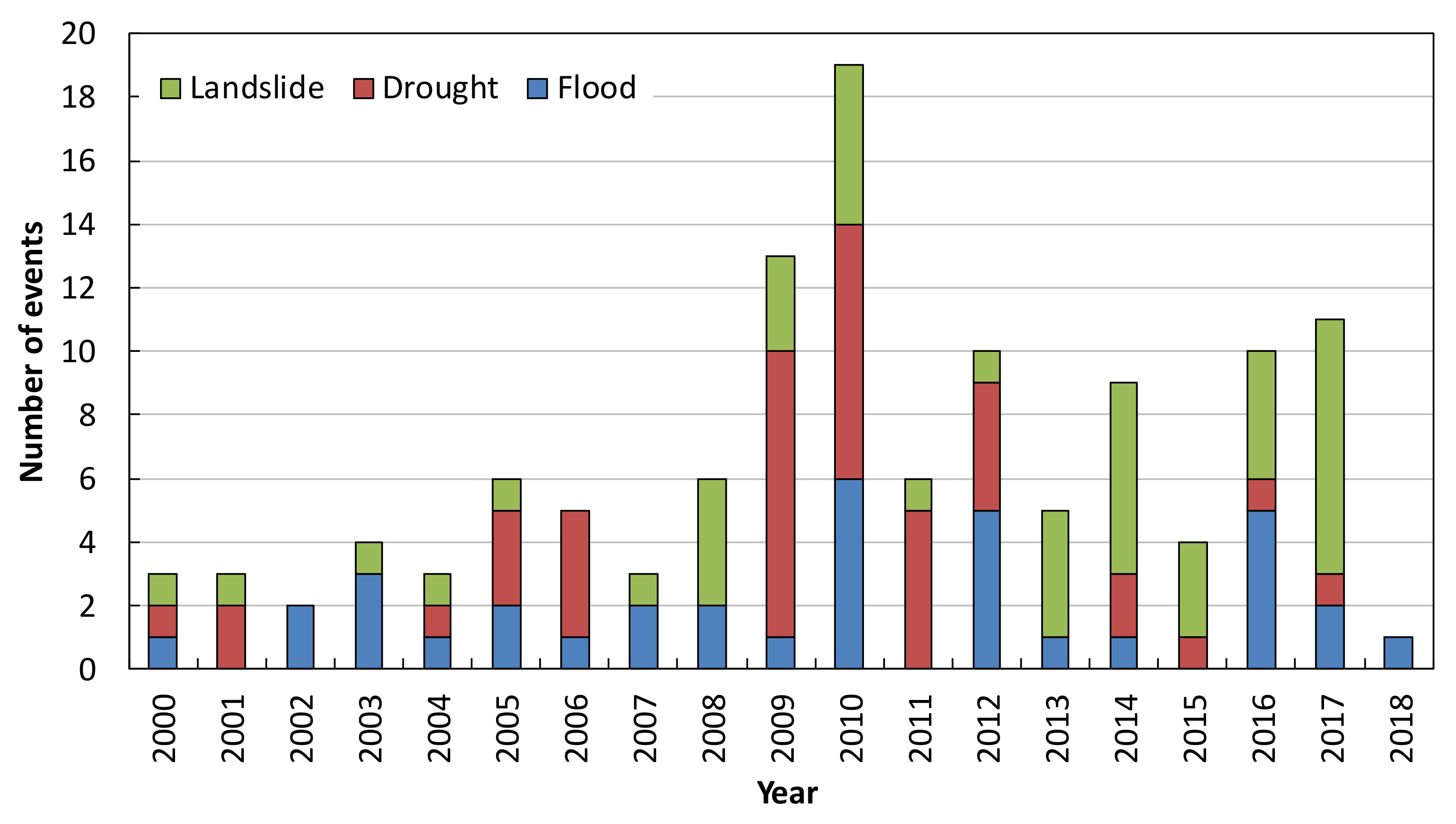
3. Results and Discussions
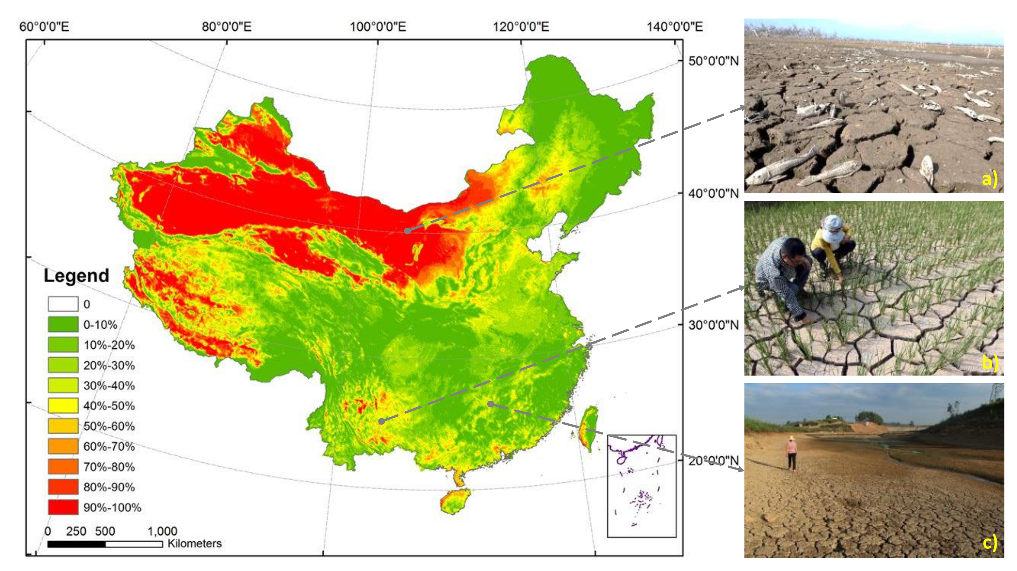
3.1. Droughts
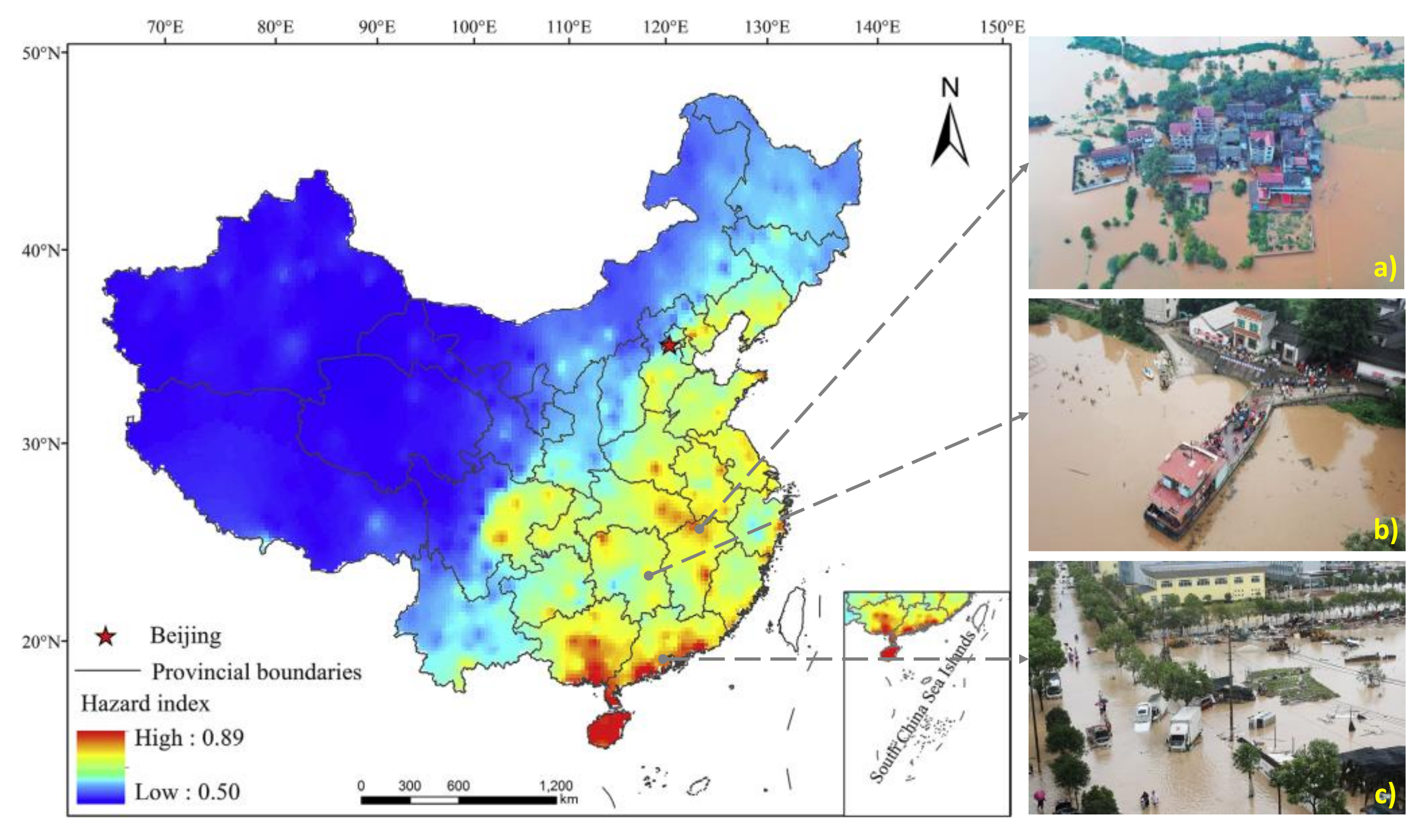
3.2. Floods
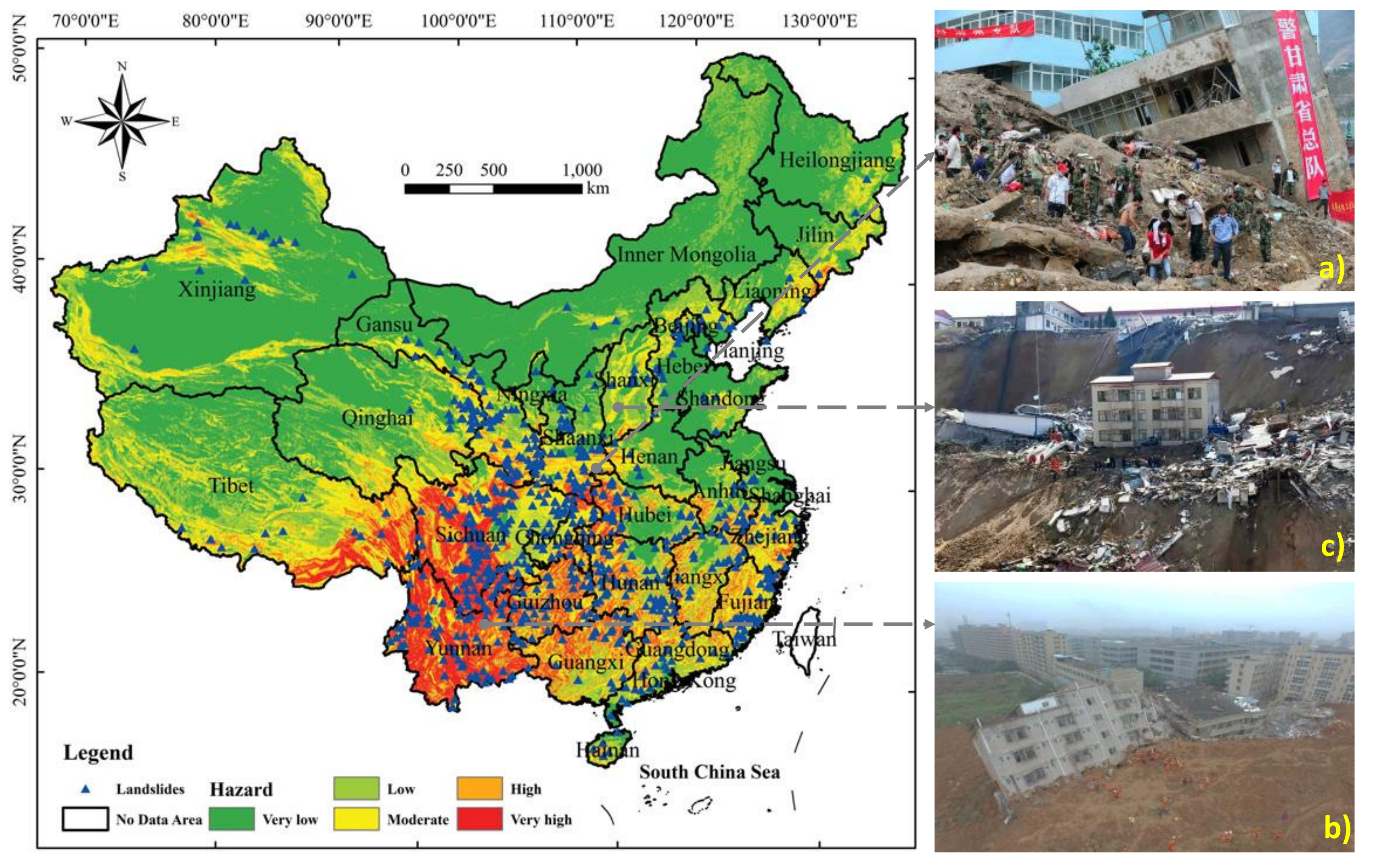
3.3. Landslides
3.4. Extreme Weather
4. Final Remarks and Outlook on Future Research
Author Contributions
Funding
Acknowledgments
Conflicts of Interest
References
- Pachauri, R.K.; Allen, M.R.; Barros, V.R.; Broome, J.; Cramer, W.; Christ, R.; Church, J.A.; Clarke, L.; Dahe, Q.; Dasgupta, P. Climate Change 2014: Synthesis Report. Contribution of Working Groups I, II and III to the Fifth Assessment Report of the Intergovernmental Panel on Climate Change; IPCC: Geneva, Switzerland, 2014. [Google Scholar]
- Field, C.B.; Barros, V.; Stocker, T.F.; Dahe, Q. Managing the Risks of Extreme Events and Disasters to Advance Climate Change Adaptation: Special Report of the Intergovernmental Panel on Climate Change; Cambridge University Press: Cambridge, UK, 2012. [Google Scholar]
- Motha, R.P. The impact of extreme weather events on agriculture in the United States. In Challenges and Opportunities in Agrometeorology; Springer: Berlin/Heidelberg, Germany, 2011; pp. 397–407. [Google Scholar]
- Vicca, S.; Balzarolo, M.; Filella, I.; Granier, A.; Herbst, M.; Knohl, A.; Longdoz, B.; Mund, M.; Nagy, Z.; Pintér, K. Remotely-sensed detection of effects of extreme droughts on gross primary production. Sci. Rep. 2016, 6, 28269. [Google Scholar] [CrossRef]
- Cogato, A.; Meggio, F.; De Antoni Migliorati, M.; Marinello, F. Extreme Weather Events in Agriculture: A Systematic Review. Sustainability 2019, 11, 2547. [Google Scholar] [CrossRef]
- Meehl, G.A.; Karl, T.; Easterling, D.R.; Changnon, S.; Pielke, R., Jr.; Changnon, D.; Evans, J.; Groisman, P.Y.; Knutson, T.R.; Kunkel, K.E. An introduction to trends in extreme weather and climate events: Observations, socioeconomic impacts, terrestrial ecological impacts, and model projections. Bull. Am. Meteorol. Soc. 2000, 81, 413–416. [Google Scholar] [CrossRef]
- Wang, Y.-J.; Huang, J.-K.; Wang, J.-X. Household and community assets and farmers’ adaptation to extreme weather event: The case of drought in China. J. Integr. Agric. 2014, 13, 687–697. [Google Scholar] [CrossRef]
- Chen, X.-L.; Liu, C.-G.; Wang, M.-M.; Zhou, Q. Causes of unusual distribution of coseismic landslides triggered by the Mw 6.1 2014 Ludian, Yunnan, China earthquake. J. Asian Earth Sci. 2018, 159, 17–23. [Google Scholar] [CrossRef]
- Ding, G.; Li, X.; Li, X.; Zhang, B.; Jiang, B.; Li, D.; Xing, W.; Liu, Q.; Liu, X.; Hou, H. A time-trend ecological study for identifying flood-sensitive infectious diseases in Guangxi, China from 2005 to 2012. Environ. Res. 2019, 176, 108577. [Google Scholar] [CrossRef]
- Griffiths, J.A.; Zhu, F.; Chan, F.K.S.; Higgitt, D.L. Modelling the impact of sea-level rise on urban flood probability in SE China. Geosci. Front. 2019, 10, 363–372. [Google Scholar] [CrossRef]
- Xu, C.; Xu, X.; Shyu, J.B.H. Database and spatial distribution of landslides triggered by the Lushan, China Mw 6.6 earthquake of 20 April 2013. Geomorphology 2015, 248, 77–92. [Google Scholar] [CrossRef]
- Yang, P.; Xia, J.; Zhang, Y.; Zhan, C.; Sun, S. How is the risk of hydrological drought in the Tarim River Basin, Northwest China? Sci. Total Environ. 2019, 693, 133555. [Google Scholar] [CrossRef]
- Zhang, N.; Song, D.; Zhang, J.; Liao, W.; Miao, K.; Zhong, S.; Lin, S.; Hajat, S.; Yang, L.; Huang, C. The impact of the 2016 flood event in Anhui Province, China on infectious diarrhea disease: An interrupted time-series study. Environ. Int. 2019, 127, 801–809. [Google Scholar] [CrossRef]
- Zhu, Y.; Xu, S.; Zhuang, Y.; Dai, X.; Lv, G.; Xing, A. Characteristics and runout behaviour of the disastrous 28 August 2017 rock avalanche in Nayong, Guizhou, China. Eng. Geol. 2019, 259, 105154. [Google Scholar] [CrossRef]
- Leng, G.; Zhang, X.; Huang, M.; Asrar, G.R.; Leung, L.R. The role of climate covariability on crop yields in the conterminous United States. Sci. Rep. 2016, 6, 33160. [Google Scholar] [CrossRef]
- Shiru, M.; Shahid, S.; Alias, N.; Chung, E.-S. Trend analysis of droughts during crop growing seasons of Nigeria. Sustainability 2018, 10, 871. [Google Scholar] [CrossRef]
- Kuriqi, A. Assessment and Quantification of Meteorological Data for Implementation of Weather Radar in Mountainous Regions. Mausam 2016, 67, 789–802. [Google Scholar]
- Alderman, K.; Turner, L.R.; Tong, S. Floods and human health: A systematic review. Environ. Int. 2012, 47, 37–47. [Google Scholar] [CrossRef] [PubMed]
- Ardıçlıoğlu, M.; Kuriqi, A. Calibration of channel roughness in intermittent rivers using HEC-RAS model: Case of Sarimsakli creek, Turkey. SN Appl. Sci. 2019, 1. [Google Scholar] [CrossRef]
- Kuriqi, A.; Ardiçlioǧlu, M. Investigation of hydraulic regime at middle part of the Loire River in context of floods and low flow events. Pollack Period. 2018, 13, 145–156. [Google Scholar] [CrossRef]
- Kuriqi, A.; Koçileri, G.; Ardiçlioğlu, M. Potential of Meyer-Peter and Müller approach for estimation of bed-load sediment transport under different hydraulic regimes. Model. Earth Syst. Environ. 2019. [Google Scholar] [CrossRef]
- Kuriqi, A.; Ardiçlioglu, M.; Muceku, Y. Investigation of seepage effect on river dike’s stability under steady state and transient conditions. Pollack Period. 2016, 11, 87–104. [Google Scholar] [CrossRef]
- Huang, H.; Chen, X.; Zhu, Z.; Xie, Y.; Liu, L.; Wang, X.; Wang, X.; Liu, K. The changing pattern of urban flooding in Guangzhou, China. Sci. Total Environ. 2018, 622, 394–401. [Google Scholar] [CrossRef]
- Sun, P.; Wen, Q.; Zhang, Q.; Singh, V.P.; Sun, Y.; Li, J. Nonstationarity-based evaluation of flood frequency and flood risk in the Huai River basin, China. J. Hydrol. 2018, 567, 393–404. [Google Scholar] [CrossRef]
- Wang, Y.-J.; Gao, C.; Zhai, J.-Q.; Li, X.-C.; Hartmann, H. Spatio-temporal changes of exposure and vulnerability to floods in China. Adv. Clim. Chang. Res. 2014, 5, 197–205. [Google Scholar] [CrossRef]
- Thomaz, E.L. The influence of traditional steep land agricultural practices on runoff and soil loss. Agric. Ecosyst. Environ. 2009, 130, 23–30. [Google Scholar] [CrossRef]
- Zhang, Y.; Zhao, Y.; Liu, B.; Wang, Z.; Zhang, S. Rill and gully erosion on unpaved roads under heavy rainfall in agricultural watersheds on China’s Loess Plateau. Agric. Ecosyst. Environ. 2019, 284. [Google Scholar] [CrossRef]
- Xiao-jun, W.; Jian-yun, Z.; Shahid, S.; ElMahdi, A.; Rui-min, H.; Zhen-xin, B.; Ali, M. Water resources management strategy for adaptation to droughts in China. Mitig. Adapt. Strateg. Glob. Chang. 2012, 17, 923–937. [Google Scholar] [CrossRef]
- Shahid, S.; Behrawan, H. Drought risk assessment in the western part of Bangladesh. Nat. Hazards 2008, 46, 391–413. [Google Scholar] [CrossRef]
- Sordo-Ward, A.; Bejarano, M.; Iglesias, A.; Asenjo, V.; Garrote, L. Analysis of Current and Future SPEI Droughts in the La Plata Basin Based on Results from the Regional Eta Climate Model. Water 2017, 9. [Google Scholar] [CrossRef]
- Naumann, G.; Barbosa, P.; Garrote, L.; Iglesias, A.; Vogt, J. Exploring drought vulnerability in Africa: An indicator based analysis to be used in early warning systems. Hydrol. Earth Syst. Sci. 2014, 18, 1591–1604. [Google Scholar] [CrossRef]
- Garrote, L.; Granados, A.; Iglesias, A. Strategies to reduce water stress in Euro-Mediterranean river basins. Sci Total Environ. 2016, 543, 997–1009. [Google Scholar] [CrossRef]
- Garrote, L. Managing Water Resources to Adapt to Climate Change: Facing Uncertainty and Scarcity in a Changing Context. Water Resour. Manag. 2017, 31, 2951–2963. [Google Scholar] [CrossRef]
- Liu, X.; Xu, X.; Yu, M.; Lu, J. Hydrological drought forecasting and assessment based on the standardized stream index in the Southwest China. Procedia Eng. 2016, 154, 733–737. [Google Scholar] [CrossRef]
- Jia, J.-Y.; Han, L.-Y.; Liu, Y.-F.; He, N.; Zhang, Q.; Wan, X.; Zhang, Y.-F.; Hu, J.-M. Drought risk analysis of maize under climate change based on natural disaster system theory in Southwest China. Acta Ecol. Sin. 2016, 36, 340–349. [Google Scholar] [CrossRef]
- Khan, N.; Shahid, S.; Ahmed, K.; Wang, X.; Ali, R.; Ismail, T.; Nawaz, N. Selection of GCMs for the projection of spatial distribution of heat waves in Pakistan. Atmos. Res. 2020, 233, 104688. [Google Scholar] [CrossRef]
- Khan, N.; Shahid, S.; Chung, E.-S.; Kim, S.; Ali, R. Influence of Surface Water Bodies on the Land Surface Temperature of Bangladesh. Sustainability 2019, 11, 6754. [Google Scholar] [CrossRef]
- Ali, K.; Abubaker, K. Long-Term Trends and Seasonality Detection of the Observed Flow in Yangtze River Using Mann-Kendall and Sen’s Innovative Trend Method. Water 2019, 11. [Google Scholar] [CrossRef]
- Ali, R.; Ismael, A.; Heryansyah, A.; Nawaz, N. Long Term Historic Changes in the Flow of Lesser Zab River, Iraq. Hydrology 2019, 6. [Google Scholar] [CrossRef]
- Ali, R.; Kuriqi, A.; Abubaker, S.; Kisi, O. Hydrologic Alteration at the Upper and Middle Part of the Yangtze River, China: Towards Sustainable Water Resource Management Under Increasing Water Exploitation. Sustainability 2019, 11. [Google Scholar] [CrossRef]
- Sediqi, M.N.; Shiru, M.S.; Nashwan, M.S.; Ali, R.; Abubaker, S.; Wang, X.; Ahmed, K.; Shahid, S.; Asaduzzaman, M.; Manawi, S.M.A. Spatio-Temporal Pattern in the Changes in Availability and Sustainability of Water Resources in Afghanistan. Sustainability 2019, 11, 5836. [Google Scholar] [CrossRef]
- Timofeev, A.; Sterin, A. Using the quantile regression method to analyze changes in climate characteristics. Russ. Meteorol. Hydrol. 2010, 35, 310–319. [Google Scholar] [CrossRef]
- Guo, E.; Liu, X.; Zhang, J.; Wang, Y.; Wang, C.; Wang, R.; Li, D. Assessing spatiotemporal variation of drought and its impact on maize yield in Northeast China. J. Hydrol. 2017, 553, 231–247. [Google Scholar] [CrossRef]
- Zhao, S.; Cong, D.; He, K.; Yang, H.; Qin, Z. Spatial-temporal variation of drought in China from 1982 to 2010 based on a modified temperature vegetation drought index (mTVDI). Sci. Rep. 2017, 7, 17473. [Google Scholar] [CrossRef] [PubMed]
- Muceku, Y.; Korini, O.; Kuriqi, A. Geotechnical Analysis of Hill’s Slopes Areas in Heritage Town of Berati, Albania. Period. Polytech. Civ. Eng. 2016, 60, 61–73. [Google Scholar] [CrossRef]
- Hungr, O.; Leroueil, S.; Picarelli, L. The Varnes classification of landslide types, an update. Landslides 2014, 11, 167–194. [Google Scholar] [CrossRef]
- Bai, S.; Wang, J.; Zhang, Z.; Cheng, C. Combined landslide susceptibility mapping after Wenchuan earthquake at the Zhouqu segment in the Bailongjiang Basin, China. Catena 2012, 99, 18–25. [Google Scholar] [CrossRef]
- Cao, J.; Zhang, Z.; Wang, C.; Liu, J.; Zhang, L. Susceptibility assessment of landslides triggered by earthquakes in the Western Sichuan Plateau. Catena 2019, 175, 63–76. [Google Scholar] [CrossRef]
- Qi, S.; Xu, Q.; Lan, H.; Zhang, B.; Liu, J. Spatial distribution analysis of landslides triggered by 2008.5.12 Wenchuan Earthquake, China. Eng. Geol. 2010, 116, 95–108. [Google Scholar] [CrossRef]
- Xing, A.; Wang, G.; Yin, Y.; Jiang, Y.; Wang, G.; Yang, S.; Dai, D.; Zhu, Y.; Dai, J. Dynamic analysis and field investigation of a fluidized landslide in Guanling, Guizhou, China. Eng. Geol. 2014, 181, 1–14. [Google Scholar] [CrossRef]
- Jiang, S.; Wen, B.-P.; Zhao, C.; Li, R.-D.; Li, Z.-H. Kinematics of a giant slow-moving landslide in Northwest China: Constraints from high resolution remote sensing imagery and GPS monitoring. J. Asian Earth Sci. 2016, 123, 34–46. [Google Scholar] [CrossRef]
- Ma, F.; Ye, A.; You, J.; Duan, Q. 2015–2016 floods and droughts in China, and its response to the strong El Niño. Sci. Total Environ. 2018, 627, 1473–1484. [Google Scholar] [CrossRef]
- Zhang, Y.; Wang, Y.; Chen, Y.; Liang, F.; Liu, H. Assessment of future flash flood inundations in coastal regions under climate change scenarios—A case study of Hadahe River basin in northeastern China. Sci. Total Environ. 2019, 693, 133550. [Google Scholar] [CrossRef]
- Xu, K.; Yang, D.; Yang, H.; Li, Z.; Qin, Y.; Shen, Y. Spatio-temporal variation of drought in China during 1961–2012: A climatic perspective. J. Hydrol. 2015, 526, 253–264. [Google Scholar] [CrossRef]
- Yang, G.; Shao, W.; Wang, H.; Han, D. Drought evolution characteristics and attribution analysis in northeast China. Procedia Eng. 2016, 154, 749–756. [Google Scholar] [CrossRef]
- Lin, Q.; Wang, Y. Spatial and temporal analysis of a fatal landslide inventory in China from 1950 to 2016. Landslides 2018, 15, 2357–2372. [Google Scholar] [CrossRef]
- Liu, X.; Miao, C. Large-scale assessment of landslide hazard, vulnerability and risk in China. Geomat. Nat. Hazards Risk 2018, 9, 1037–1052. [Google Scholar] [CrossRef]
- Tang, C.; Ma, G.; Chang, M.; Li, W.; Zhang, D.; Jia, T.; Zhou, Z. Landslides triggered by the 20 April 2013 Lushan earthquake, Sichuan Province, China. Eng. Geol. 2015, 187, 45–55. [Google Scholar] [CrossRef]
- Zhao, S.; Chigira, M.; Wu, X. Buckling deformations at the 2017 Xinmo landslide site and nearby slopes, Maoxian, Sichuan, China. Eng. Geol. 2018, 246, 187–197. [Google Scholar] [CrossRef]
- Ayantobo, O.O.; Li, Y.; Song, S.; Yao, N. Spatial comparability of drought characteristics and related return periods in mainland China over 1961–2013. J. Hydrol. 2017, 550, 549–567. [Google Scholar] [CrossRef]
- Liu, Z.; Li, C.; Zhou, P.; Chen, X. A probabilistic assessment of the likelihood of vegetation drought under varying climate conditions across China. Sci. Rep. 2016, 6, 35105. [Google Scholar] [CrossRef]
- Wang, S.; Mo, X.; Hu, S.; Liu, S.; Liu, Z. Assessment of droughts and wheat yield loss on the North China Plain with an aggregate drought index (ADI) approach. Ecol. Indic. 2018, 87, 107–116. [Google Scholar] [CrossRef]
- Wu, J.; Zhou, L.; Liu, M.; Zhang, J.; Leng, S.; Diao, C. Establishing and assessing the Integrated Surface Drought Index (ISDI) for agricultural drought monitoring in mid-eastern China. Int. J. Appl. Earth Obs. Geoinf. 2013, 23, 397–410. [Google Scholar] [CrossRef]
- Zhao, P.; Lü, H.; Yang, H.; Wang, W.; Fu, G. Impacts of climate change on hydrological droughts at basin scale: A case study of the Weihe River Basin, China. Quat. Int. 2019, 513, 37–46. [Google Scholar] [CrossRef]
- Cong, D.; Zhao, S.; Chen, C.; Duan, Z. Characterization of droughts during 2001–2014 based on remote sensing: A case study of Northeast China. Ecol. Inform. 2017, 39, 56–67. [Google Scholar] [CrossRef]
- Pradhan, N.S.; Fu, Y.; Zhang, L.; Yang, Y. Farmers’ perception of effective drought policy implementation: A case study of 2009–2010 drought in Yunnan province, China. Land Use Policy 2017, 67, 48–56. [Google Scholar] [CrossRef]
- Xu, P.; Zhou, T.; Zhao, X.; Luo, H.; Gao, S.; Li, Z.; Cao, L. Diverse responses of different structured forest to drought in Southwest China through remotely sensed data. Int. J. Appl. Earth Obs. Geoinf. 2018, 69, 217–225. [Google Scholar] [CrossRef]
- Zhang, D.; Chen, P.; Zhang, Q.; Li, X. Copula-based probability of concurrent hydrological drought in the Poyang lake-catchment-river system (China) from 1960 to 2013. J. Hydrol. 2017, 553, 773–784. [Google Scholar] [CrossRef]
- Sun, F.; Mejia, A.; Zeng, P.; Che, Y. Projecting meteorological, hydrological and agricultural droughts for the Yangtze River basin. Sci. Total Environ. 2019, 696, 134076. [Google Scholar] [CrossRef]
- Xu, K.; Yang, D.; Xu, X.; Lei, H. Copula based drought frequency analysis considering the spatio-temporal variability in Southwest China. J. Hydrol. 2015, 527, 630–640. [Google Scholar] [CrossRef]
- Zhang, H.; Chang, J.; Gao, C.; Wu, H.; Wang, Y.; Lei, K.; Long, R.; Zhang, L. Cascade hydropower plants operation considering comprehensive ecological water demands. Energy Convers. Manag. 2019, 180, 119–133. [Google Scholar] [CrossRef]
- Yang, H.; Wang, H.; Fu, G.; Yan, H.; Zhao, P.; Ma, M. A modified soil water deficit index (MSWDI) for agricultural drought monitoring: Case study of Songnen Plain, China. Agric. Water Manag. 2017, 194, 125–138. [Google Scholar] [CrossRef]
- Song, L.; Li, Y.; Ren, Y.; Wu, X.; Guo, B.; Tang, X.; Shi, W.; Ma, M.; Han, X.; Zhao, L. Divergent vegetation responses to extreme spring and summer droughts in Southwestern China. Agric. For. Meteorol. 2019, 279, 107703. [Google Scholar] [CrossRef]
- Sun, S.; Li, Q.; Li, J.; Wang, G.; Zhou, S.; Chai, R.; Hua, W.; Deng, P.; Wang, J.; Lou, W. Revisiting the evolution of the 2009–2011 meteorological drought over Southwest China. J. Hydrol. 2019, 568, 385–402. [Google Scholar] [CrossRef]
- Huang, S.; Ye, G.; Lin, J.; Chen, K.; Xu, X.; Ruan, H.; Tan, F.; Chen, H.Y. Autotrophic and heterotrophic soil respiration responds asymmetrically to drought in a subtropical forest in the Southeast China. Soil Biol. Biochem. 2018, 123, 242–249. [Google Scholar] [CrossRef]
- Gong, L.; Hou, S.; Su, B.; Miao, K.; Zhang, N.; Liao, W.; Zhong, S.; Wang, Z.; Yang, L.; Huang, C. Short-term effects of moderate and severe floods on infectious diarrheal diseases in Anhui Province, China. Sci. Total Environ. 2019, 675, 420–428. [Google Scholar] [CrossRef] [PubMed]
- Kai, W.; Deyi, C.; Zhaohui, Y. Flood control and management for the transitional Huaihe River in China. Procedia Eng. 2016, 154, 703–709. [Google Scholar] [CrossRef]
- Lyu, H.-M.; Xu, Y.-S.; Cheng, W.-C.; Arulrajah, A. Flooding hazards across southern China and prospective sustainability measures. Sustainability 2018, 10, 1682. [Google Scholar] [CrossRef]
- Liu, Z.; Ding, G.; Zhang, Y.; Lao, J.; Liu, Y.; Zhang, J.; Lu, L.; Liu, Q.; Jiang, B. Identifying different types of flood–sensitive diarrheal diseases from 2006 to 2010 in Guangxi, China. Environ. Res. 2019, 170, 359–365. [Google Scholar] [CrossRef]
- Liu, X.; Liu, Z.; Ding, G.; Jiang, B. Projected burden of disease for bacillary dysentery due to flood events in Guangxi, China. Sci. Total Environ. 2017, 601, 1298–1305. [Google Scholar] [CrossRef]
- Wu, H.-L.; Cheng, W.-C.; Shen, S.-L.; Lin, M.-Y.; Arulrajah, A. Variation of hydro-environment during past four decades with underground sponge city planning to control flash floods in Wuhan, China: An overview. Undergr. Space 2019. [Google Scholar] [CrossRef]
- Fan, W.; Lv, J.; Cao, Y.; Shen, M.; Deng, L.; Wei, Y. Characteristics and block kinematics of a fault-related landslide in the Qinba Mountains, western China. Eng. Geol. 2019, 249, 162–171. [Google Scholar] [CrossRef]
- Leng, Y.; Peng, J.; Wang, Q.; Meng, Z.; Huang, W. A fluidized landslide occurred in the Loess Plateau: A study on loess landslide in South Jingyang tableland. Eng. Geol. 2018, 236, 129–136. [Google Scholar] [CrossRef]
- Liu, W.; Yan, S.; He, S. Landslide damage incurred to buildings: A case study of Shenzhen landslide. Eng. Geol. 2018, 247, 69–83. [Google Scholar] [CrossRef]
- Mi, J.; Liu, R.; Zhang, S.; Hou, H.; Yang, Y.; Chen, F.; Zhang, L. Vegetation patterns on a landslide after five years of natural restoration in the Loess Plateau mining area in China. Ecol. Eng. 2019, 136, 46–54. [Google Scholar] [CrossRef]
- Xu, S.; Niu, R. Displacement prediction of Baijiabao landslide based on empirical mode decomposition and long short-term memory neural network in Three Gorges area, China. Comput. Geosci. 2018, 111, 87–96. [Google Scholar] [CrossRef]
- Zhang, S.; Xu, Q.; Hu, Z. Effects of rainwater softening on red mudstone of deep-seated landslide, Southwest China. Eng. Geol. 2016, 204, 1–13. [Google Scholar] [CrossRef]
- Li, M.; Zhang, L.; Dong, J.; Tang, M.; Shi, X.; Liao, M.; Xu, Q. Characterization of pre-and post-failure displacements of the Huangnibazi landslide in Li County with multi-source satellite observations. Eng. Geol. 2019, 257, 105140. [Google Scholar] [CrossRef]
- Sun, Q.; Zhang, L.; Ding, X.; Hu, J.; Li, Z.; Zhu, J. Slope deformation prior to Zhouqu, China landslide from InSAR time series analysis. Remote Sens. Environ. 2015, 156, 45–57. [Google Scholar] [CrossRef]
- Li, G.; Lei, Y.; Yao, H.; Wu, S.; Ge, J. The influence of land urbanization on landslides: An empirical estimation based on Chinese provincial panel data. Sci. Total Environ. 2017, 595, 681–690. [Google Scholar] [CrossRef]
- Huang, D.; Li, Y.Q.; Song, Y.X.; Xu, Q.; Pei, X.J. Insights into the catastrophic Xinmo rock avalanche in Maoxian county, China: Combined effects of historical earthquakes and landslide amplification. Eng. Geol. 2019, 258, 105158. [Google Scholar] [CrossRef]
- Li, Z.-Y.; Huang, X.-H.; Yu, D.; Su, J.-R.; Xu, Q. Broadband-seismic analysis of a massive landslide in southwestern China: Dynamics and fragmentation implications. Geomorphology 2019, 336, 31–39. [Google Scholar] [CrossRef]
- Fan, X.; Zhan, W.; Dong, X.; van Westen, C.; Xu, Q.; Dai, L.; Yang, Q.; Huang, R.; Havenith, H.-B. Analyzing successive landslide dam formation by different triggering mechanisms: The case of the Tangjiawan landslide, Sichuan, China. Eng. Geol. 2018, 243, 128–144. [Google Scholar] [CrossRef]
- Chen, K.-T.; Wu, J.-H. Simulating the failure process of the Xinmo landslide using discontinuous deformation analysis. Eng. Geol. 2018, 239, 269–281. [Google Scholar] [CrossRef]
- Tang, M.; Xu, Q.; Yang, H.; Li, S.; Iqbal, J.; Fu, X.; Huang, X.; Cheng, W. Activity law and hydraulics mechanism of landslides with different sliding surface and permeability in the Three Gorges Reservoir Area, China. Eng. Geol. 2019, 260, 105212. [Google Scholar] [CrossRef]
- Liu, G.; Guo, H.; Perski, Z.; Fan, J.; Bai, S.; Yan, S.; Song, R. Monitoring the slope movement of the Shuping landslide in the Three Gorges Reservoir of China, using X-band time series SAR interferometry. Adv. Space Res. 2016, 57, 2487–2495. [Google Scholar] [CrossRef]
- Hong, H.; Ilia, I.; Tsangaratos, P.; Chen, W.; Xu, C. A hybrid fuzzy weight of evidence method in landslide susceptibility analysis on the Wuyuan area, China. Geomorphology 2017, 290, 1–16. [Google Scholar] [CrossRef]
- Luo, J.; Pei, X.; Evans, S.G.; Huang, R. Mechanics of the earthquake-induced Hongshiyan landslide in the 2014 Mw 6.2 Ludian earthquake, Yunnan, China. Eng. Geol. 2019, 251, 197–213. [Google Scholar] [CrossRef]
- Li, M.; Zhang, L.; Shi, X.; Liao, M.; Yang, M. Monitoring active motion of the Guobu landslide near the Laxiwa Hydropower Station in China by time-series point-like targets offset tracking. Remote Sens. Environ. 2019, 221, 80–93. [Google Scholar] [CrossRef]
- Zhao, Y.; Wang, R.; Jiang, Y.; Liu, H.; Wei, Z. GIS-based logistic regression for rainfall-induced landslide susceptibility mapping under different grid sizes in Yueqing, Southeastern China. Eng. Geol. 2019, 105147. [Google Scholar] [CrossRef]
- Gao, Y.; Yin, Y.; Li, B.; He, K.; Wang, X. Post-failure behavior analysis of the Shenzhen “12.20” CDW landfill landslide. Waste Manag. 2019, 83, 171–183. [Google Scholar] [CrossRef]
- Přívara, A.; Přívarová, M. Nexus between Climate Change, Displacement and Conflict: Afghanistan Case. Sustainability 2019, 11, 5586. [Google Scholar] [CrossRef]
- Wong, L. China’s urban migrants-the public policy challenge. Pac. Aff. 1994, 67, 335–355. [Google Scholar] [CrossRef]
- Deng, Q. Natural disasters, migration and urban insecurity in China. In Proceedings of the Interconnection among Global Problems in Northeast Asia Workshop, Paju, Korea, 16–17 March 2009. [Google Scholar]
- Pei, Q. Migration for survival under natural disasters: A reluctant and passive choice for agriculturalists in historical China. Sci. China Earth Sci. 2017, 60, 2089–2096. [Google Scholar] [CrossRef]
- Vina, A.; Chen, X.; McConnell, W.J.; Liu, W.; Xu, W.; Ouyang, Z.; Zhang, H.; Liu, J. Effects of natural disasters on conservation policies: The case of the 2008 Wenchuan Earthquake, China. Ambio 2011, 40, 274–284. [Google Scholar] [CrossRef] [PubMed]
- McCarthy, J.J.; Canziani, O.F.; Leary, N.A.; Dokken, D.J.; White, K.S. Climate change 2001: Impacts, adaptation, and vulnerability: Contribution of Working Group II to the third assessment report of the Intergovernmental Panel on Climate Change; Cambridge University Press: Cambridge, UK, 2001; Volume 2. [Google Scholar]
- Schöfberger, I. Environmental change and translocal vulnerability in Senegal. Ger. Dev. Inst. Dtsch. Inst. Entwickl. Migr. Environ. Clim. Chang. Policy Brief Ser. 2018, 3, 1–8. [Google Scholar]
- Smith, M.D. An ecological perspective on extreme climatic events: A synthetic definition and framework to guide future research. J. Ecol. 2011, 99, 656–663. [Google Scholar] [CrossRef]


| Class | Script of Extraction |
|---|---|
| 1. Extreme Weather Events (subject environment and human) | (TITLE-ABS*-KEY (extreme AND weather AND event in China)) AND (LIMIT-TO (SUBJAREA, "Environment and Human")) |
| 2. Extreme Weather Events (Mitigation and Adaptations) | (TITLE-ABS-KEY (extreme AND weather event in China)) AND (TITLE-ABS-KEY (Adaptation and Mitigation)) |
| Location | Events | Cause | Consequence | Mitigation and Adaptation Measure | Reference | |
|---|---|---|---|---|---|---|
| Environment | Human | |||||
| Yunnan Province | 2009 and 2010 | A reduction in precipitation and abnormal high temperature. | Severe water shortages dried up lakes, exposed desiccated aquatic animals, and affected 39.94 million hectares of crops. | Shortage of drinking water 9.65 million residents Almost 135 million people dead, 0.69 million USD indirect economic loss in agriculture, and 97 million livestock dead. | Long-term adaptation techniques, for example, awareness-raising, capacity building, watershed management, and conservation of resources, need to be reinforced at the local level. | [34,60,66,67] |
| Heilongjiang province | 2010 | Natural characteristic indicator of precipitation, and the human activity characteristic index including effective irrigation area, sown area. | Drought affected grain product. | They were not reported. | The significant extension of the sown region and the reduced irrigation water together in the active irrigation region exacerbated drought growth. | [55] |
| Heilongjiang, Jilin and Liaoning Province | 2001 | Because of geographical location and impacted by climate disaster. | They were not reported. | Approximately 890 million yuan economic loss per year. | The effect of drought on maize yield accurately and building a multi-hazard evaluation model to evaluate meteorological risks, and their impact on yield is crucial for future research. | [43] |
| Shaanxi Province | 2012 | High rate and level of loss in agricultural production. | Water shortage crop failure. | Locust plagues. | Using the cross-base predictor selection method, the XG Boost model demonstrated the best predictive capabilities. | [27] |
| Yangtze River | 2005 and 2011 | Severe climate conditions. | Damaged eco-environment. | Socio-economic consequences. | Scaling down the GRACE information to a finer-scaled resolution dependent on a soil surface model and after that, using downscaled information to explore the spatial variations in the characterization of hydrological drought. | [54,68,69], |
| Mid-eastern China | 2006 | Uneven spatial distribution of precipitation caused by the East Asian monsoon climate. | Affected crops, grassland, and deciduous broadleaf forest. | The Integrated Surface Drought Index (ISDI) was established as a fresh technique. | [63] | |
| Southwest China | 2005,2006 and 2012 | Climate change geomorphology and mountainous topography alteration. | Caused the maize production to decrease by 4.7%. | Lack of freshwater for people. | Comprehensive analysis of spatiotemporal variation from a climatic perspective based on multiple drought indices to improve the accuracy of recognized drought events. | [35,70] |
| China | 2006, 2009 to 2010, and 2017 | Monsoon climate change. | Affected agriculture, water availability, and ecosystems. Grain loss of 16.26 billion kilograms. | Impacts on the economy and society. | The Palmer Drought Severity Index high-accuracy self-calibration to explore the drought variation in China. | [71] |
| North China plane | 2012 and 2009 | Climate change. | Crop yield loss of 157 million acres of farmland being affected. | Drought indices were used to develop the North China Plain (NCP) aggregate drought index (ADI) to evaluate the impact of drought on crop yield. | [44,62] | |
| Songnen Plain | 2000 and 2012 | Agricultural drought disaster type. | Crops. | Lack of food for the people. | Verify and evaluate the applicability of this recently proposed soil water deficit index (MSWDI) to monitor agricultural drought to advance the management of agricultural water. | [72] |
| Tarim River Basin | 2009 | Climate change. | The severe loss of oasis agriculture. | Modelling the connection between ecological water supply and irrigation water supply through the Community Land Model-Distributed Time-Variant Gain Model (CLM-DTVGM) and a copula feature. | [12] | |
| Southwestern China | 2009 and 2011 | Climate change. | Declined vegetation productivity, increased tree impermanence. The 2011 summer drought dried up more than 1500 small reservoirs affecting about 2.5 million ha farmland. | Drinking water shortages for 9.65 million people, 21 million people lacked drinking water, and economic losses reached almost 30 billion USD. | The resistance of vegetation growth to drought must be recognized by integrating field measurements and satellite observations. | [73,74] |
| Shaanxi, Qinghai, and Guangdong | 2009 and 2011 | Climate change. | Crop yields. | They were not reported. | Increasing education and social capital improve farmers’ capacity to adapt and the policy of strengthening community assets to adapt to extreme weather events. | [7] |
| Northeast China | 2001 and 2014 | High fluctuation in monthly rainfall. | Northeast China was attacked by drought in 2001, and the drought area reached 3.75 million hectares in the Heilongjiang region, and 2.7 million hectares in Jilin Province of which the area attacked severely by drought was 2.04 million hectares. | It was causing a significant economic loss. | Three indices are the Standardized Monthly Precipitation Anomaly Percentage (NPA), the Vegetation Health Index (VHI), and the Normalized Vegetation Supply Water Index (NVSWI.) Three broad indices use precise and efficient tracking of drought is very important for ensuring grain production. | [65] |
| Pearl River basin | 2016 | Precipitation anomalies. | They were not reported. | They were not reported. | The response of extreme hydro-climates to El Niño can give useful data to enhance flood forecasting and drought in China. | [52] |
| Weihe River Basin, Gansu Province | 2004 | Climate changes. | They were not reported. | They were not reported. | Temperature impacts on hydrological droughts cannot be overlooked and have indirect effects (rainfall patterns) and direct (evaporation and runoff generation). | [64] |
| Southeast China | 2014 and 2015 | Climate change. | They were not reported. | They were not reported. | The asymmetric response to drought between autotrophic soil respiration (Ra) and heterotrophic soil respiration (Rh) should be taken into consideration when predicting ecosystem Creation to future drought occurrences. | [75] |
| Poyang lake-catchment-river system | 2011 | Significantly low precipitation. | They were not reported. | They were not reported. | Adaptation strategy to mitigate the worsening condition of the Poyang lake-catchment-river scheme should be created as a matter of urgency. | [68] |
| Location | Events | Cause | Consequence | Mitigation and Adaptation Measure | Reference | |
|---|---|---|---|---|---|---|
| Environment | Human | |||||
| Liaoning Province | 2012 | Heavy rain. | Not reported. | 36 deaths. | Structural measures, for example, the construction of reservoirs for flood control and the regular maintenance of riverbeds and banks, are regarded as critical. Equally essential are non-structural measures, including emergency planning. | [53] |
| Huaihe River | 2003 and 2007 | Unique natural future. | Sixteen million hectares of arable land flooded by floods; 3.17 million hectares were cultivated land in the Yangtze River basin. | Cause migration and thus resettlement issues and direct economic loss. | Building flood structures can cause risk propagation, so we must correctly treat risk propagation; various regions must share flood risk plans and build mechanisms for flood risk compensation and flood insurance. | [24,77] |
| Anhui Province, Jiangsu, and Guangxi | 2004, 2005, 2012, 2016, and 2017 | Heavy rainfall. | 1120-thousand-hectare crop area was devastated. | 12.8 million people were 34 people killed; the direct economic loss was assessed to be 8.25 billion US dollars. | It is recommended that local public health organizations create intervention programs to avoid and control the danger of diarrhea when a significant flood happens, particularly in the regions close to water bodies and among vulnerable communities. | [9,13,25,78,79,80] |
| Wuhan | 2016 | Heavy rainstorm. | 32,160 ha of crops and vegetables were destroyed. | Fourteen people died, and one person went missing. A total of 757 000 people was resettled, and 5 848 houses were warped. Economic losses were assessed to be higher than 22.65 billion RMB (3.3 billion USD). | It is suggested that the Sponge City (SPC) idea be implemented to replace traditional green infrastructure. | [23,81] |
| Fujian Province | 2013 | Typhoon Fitow, massive rainfall reservoirs, and drainage systems were already at a high level. | It affected three million people and cost over 0.33 billion US$. | Linking the flood model to real-time predictions of rainfall and tide would enable the computation of flood probability in real-time and thus take effective action to decrease flood effects. | [10] | |
| Guangzhou | 2010 and 2014 | Extreme rainfall event. | Caused many streets to become inundated. | It was leading to severe transport disorder. | It is also suggested that urban flooding records in areas with flood danger be collected regularly so that more suitable policies and interventions can be established to mitigate urban flooding. | [23] |
| Xinjiang Province | 2010 | Human damaged was very severe, with some 3200 fatalities nationwide and a thousand missing. | Seventy-nine fatalities and 11.6 billion CN¥ (1.85 billion US$, in 2012 exchange rate) losses. | China has embarked on an ambitious and vigorous task of improving flood preparedness through both structural (“hard”) and non-structural ("soft"), measures, including flood retention and urban water management to mitigate flash and urban flood burdens. | [23,81] | |
| Location | Events | Cause | Consequence | Mitigation and Adaptation Measure | Reference | |
|---|---|---|---|---|---|---|
| Environment | Human | |||||
| Zhouqu County | 2010 and 2013 | Slope deformation Substantial erosion and an active fault zone. | They were not reported. | They were not reported. | Developing empirical models to predict landslides events. The time series of slope deformation has a robust correlation with the area’s precipitation. | [51,89] |
| China | 2000, 2005, 2014, and 2015 | Increase in extreme precipitation in China Earthquakes. | Property and Environmental damage and over 1700 dead. | The interactions between rainfall and topography, soil lithology, vegetation, and population density are closer to the spatial distribution of deadly landslides than each factor. | [56,57,90] | |
| Sichuan Province | 2008, 2013, and 2017 | Lushan earthquake, a sharp shock happened. | The avalanche also blocked roads and the Songpinggou River. | Ten thousand nine hundred and ninety-six total deaths, approximately 690 fatalities per year 120 deaths from 2000–2015. | Ground motion is the basic triggering impact for these landslides and is thus the central control the distribution of landslides. | [11,49,58,59,87,88,91,92,93,94] |
| Three Gorges Reservoir Area | 2014 and 2003 | Moreover, the reservoir water level reached its maximum level of 175 m, and substantial rainfall-induced landslide deformation occurred. | They were not reported. | Two hundred and seventeen fatalities; 13,484 persons were injured, and about 193,000 houses were destroyed. It was estimated that the total economic losses exceeded 50 billion Yuan. Extensive damage to housing settlements and irrigation channels. Highways and bridges were also blocked and destroyed; several cities were isolated. | The effect of filling reservoir water on landslide stability will shift from favorable to worse, and the effect of the water drawn from the reservoir on the landslide stability will alter from worse to better if the water fluctuation rate of the reservoir is less than or equal to the coefficient of permeability, the effect, and trend of the landslide development will be more evident. | [95,96] |
| Jiangliu Village on the South Jingyang tableland | 2016 | Soft foundation impact liquefaction became the primary reason that the landslide occurred. | Affected farmland. | Seriously threatens people’s safety and property | Large pores within the slope and the vertical joints were preferential infiltration passages for irrigation water, and landslides in the flow stated that the ground layer in the reduced portion of the slope before the landslide was in a completely saturated condition. | [83] |
| Guangchang area Jiangxi province | Last ten years | Heavy rainfall. | They were not reported. | It has impacted 1392 people, including some killed, made homeless, among others. | Consequently, the outcome shows that the J48 Decision Tree (JDT) with Rotation Forest is the best-optimized model and can be regarded as a successful technique for mapping landslide susceptibility for greater precision in comparable instances. | [97] |
| Shenzhen | 2015 | Construction solid waste. | Had catastrophic consequences. | Buried or pushed over 33 buildings in its path, namely, 24 workshops, three dormitory buildings, and six residential buildings, and caused 73 deaths and 17 injures. | The reasonable agreement between the damage observed and the simulation presented by the procedural analysis provides evidence indicating the usefulness of both the model of dilatancy used to study the landslide movement and the method of dynamic finite element analysis implemented to the exposed structure. | [84] |
| Wuyuan area | 2014 | Numerous rainfall | Not reported. | A total of 2115 people is affected. The economic loss of 4 million USD; destroyed homes and agriculture | A decision support instrument could use the results of this research to implement infrastructure security plans and risk reduction initiatives effectively. | [97] |
| Yunnan | 2014 and 2003 | Ludian earthquake Seismogenic fault. Shallow slope failures and rock or soil slides | It blocked the Niulan river creating a reservoir that had a high likelihood of landslide dam failure and subsequent downstream flood. | Created an elevated risk to the population, and effective emergency mitigation measures were carried out, the risk of dam break was decreased significantly. | The properties of the "best-fit" input strength are equivalent, but not the actual power of the displaced material or the adjacent stable base rock. | [8,98] |
| Qinba Mountains, southern Shaanxi Province western China | 2010 | Geological factors and precipitation. | Not reported. | 29 deaths | 3D analyses utilizing 3DEC can well represent the block kinematics of instability; the impact of rainfall was modeled on the numerical analysis by decreasing the strengths of the joints to defined values. Therefore, 3D numerical results are still limited. | [82] |
| Yellow River in China. | 2009 | Revealing an acceleration of deformation after the impoundment of the reservoir | Not reported. | They were not reported. | Quantitative validation based on ground-real-time information, track landslides and invert slide depth based on the 3D displacement field. | [99] |
| Nayong, Guizhou, China | 2017 and 2010 | Disastrous rock avalanche occurred heavy rainfall | The landslide involved the failure of about 985,000 m3 of sandstone from the source area. The displaced materials traveled about 1300 m with a descent of about 400 m, covering an area of 129,000 m2, with the final volume 1,840,000 m3, approximately. | Killed 35 people and destroyed 23 houses. | Techniques combined the DAN3D model with seismic signal and captured video could give useful rheological models and parameters for predicting rock avalanche comparable geological characteristics to the recorded events. | [14,50] |
| Yueqing of Zhejiang Province | 2004 | Typhoon | Not reported. | Forty-two deaths, 288 collapse houses, and direct economic loss of 3,830,000 RMB. | The findings of coarse resolution information may also be acceptable if information resolution is near to the mean landslide magnitude. This technique can also be adopted when obtaining high-resolution information is hard or very costly. | [100] |
| Loess Plateau | 2001 | Environmental condition. | Impacts on natural vegetation. | They were not reported. | Natural regeneration at the bottom and center of the landslide was more efficient, which disclosed that modifications in topography could influence revegetation. The seed bank was regarded to be a significant variable influencing natural regeneration in the soil. | [85] |
| Shenzhen, Guangdong, south-eastern China | 2015 | Slope failure | Not reported. | Seventy-seven people were dead, and 33 buildings that were directly in the path of the landslide were buried or damaged. | Use the DAN3D technique to split the route of movement, pick the designs, and enter the parameters. | [101] |
| Wenchuan | 2008 | Earthquake area is situated in seismic belt and mountainous with steep topography and high erosion features | Not reported. | They were not reported. | Human engineering operations may boost the probability of landslides; therefore, tourism-related human engineering operations in landslide susceptibility studies should not be overlooked. | [48] |
| Gansu | 2010 | Heavy rainfall | Not reported. | Killed 1287 people. | The forecast capacity assessment indicates that the two distinct maps of susceptibility and the ultimate embedded map of vulnerability to landslides could also be used as urgent reaction measures for scheduling spatial development. | [47] |
| Shenzhen | 2016 | Deep geological and geomorphological fractures. | They were not reported. | Killed 77 people. | Certain factors, such as flood releases (which are state-regulated), should be considered. However, the variables that can lead to abrupt declines in the reservoir level, which causes landslide deformation to remain unsure. | [86] |
© 2020 by the authors. Licensee MDPI, Basel, Switzerland. This article is an open access article distributed under the terms and conditions of the Creative Commons Attribution (CC BY) license (http://creativecommons.org/licenses/by/4.0/).
Share and Cite
Ali, R.; Kuriqi, A.; Kisi, O. Human–Environment Natural Disasters Interconnection in China: A Review. Climate 2020, 8, 48. https://doi.org/10.3390/cli8040048
Ali R, Kuriqi A, Kisi O. Human–Environment Natural Disasters Interconnection in China: A Review. Climate. 2020; 8(4):48. https://doi.org/10.3390/cli8040048
Chicago/Turabian StyleAli, Rawshan, Alban Kuriqi, and Ozgur Kisi. 2020. "Human–Environment Natural Disasters Interconnection in China: A Review" Climate 8, no. 4: 48. https://doi.org/10.3390/cli8040048
APA StyleAli, R., Kuriqi, A., & Kisi, O. (2020). Human–Environment Natural Disasters Interconnection in China: A Review. Climate, 8(4), 48. https://doi.org/10.3390/cli8040048