Water Resource Management in Dry Zonal Paddy Cultivation in Mahaweli River Basin, Sri Lanka: An Analysis of Spatial and Temporal Climate Change Impacts and Traditional Knowledge

 ,
, 

Abstract
:
1. Introduction
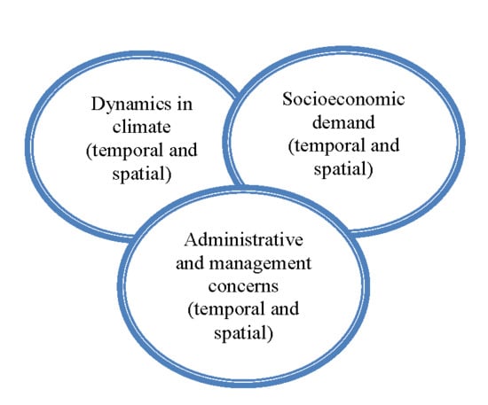
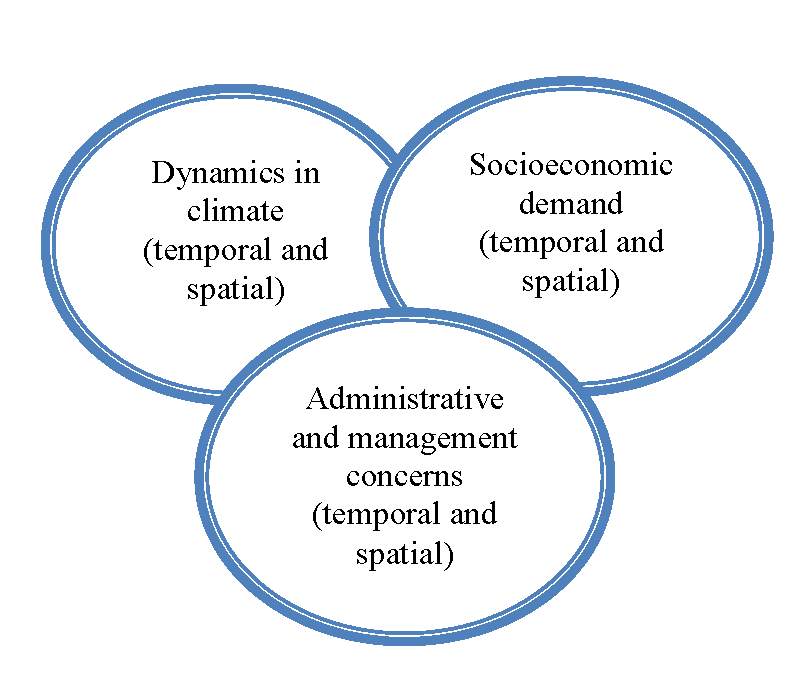
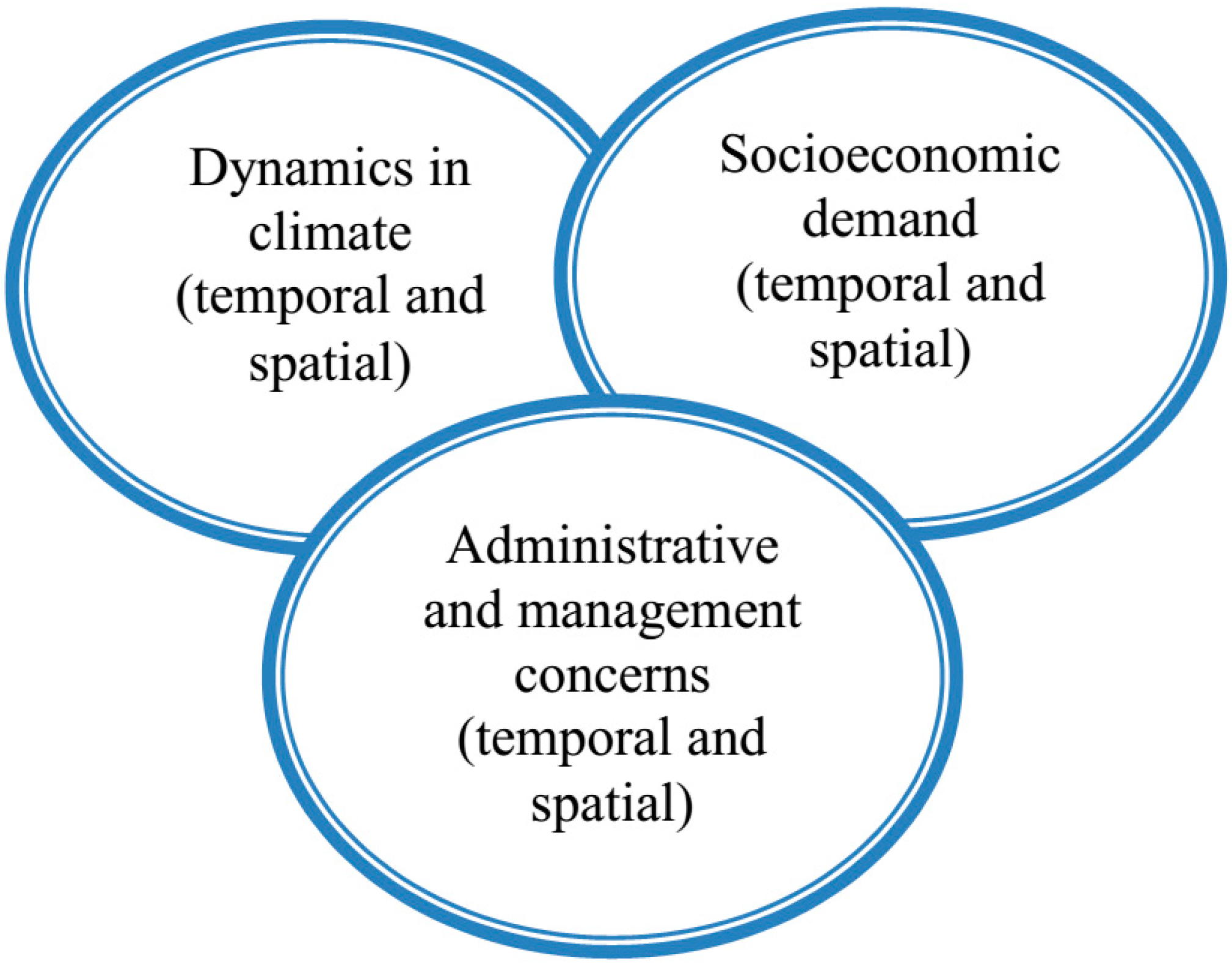
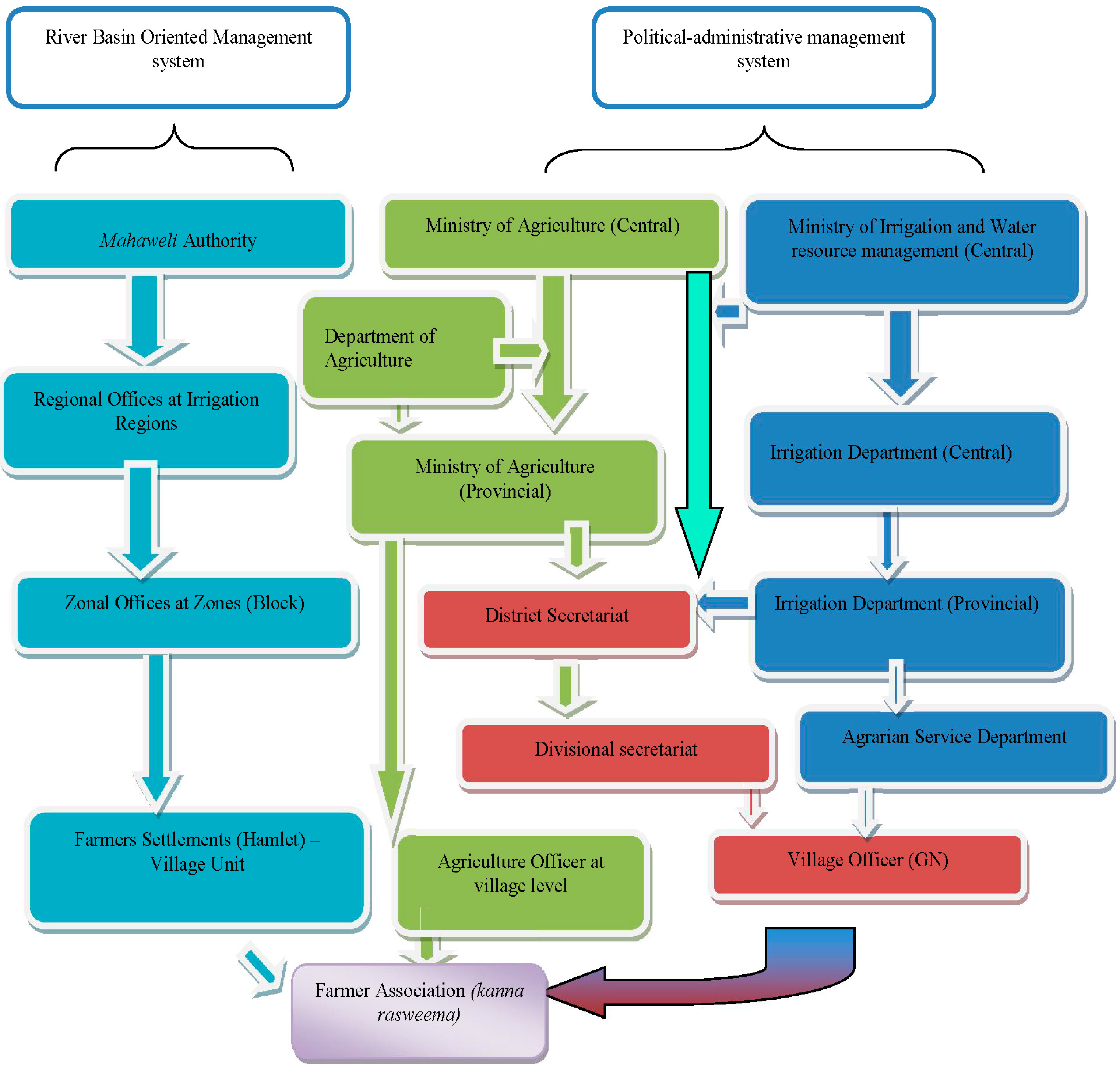
2. Theoretical Framework: Cross-Scale Inquiries of Water Resource Management
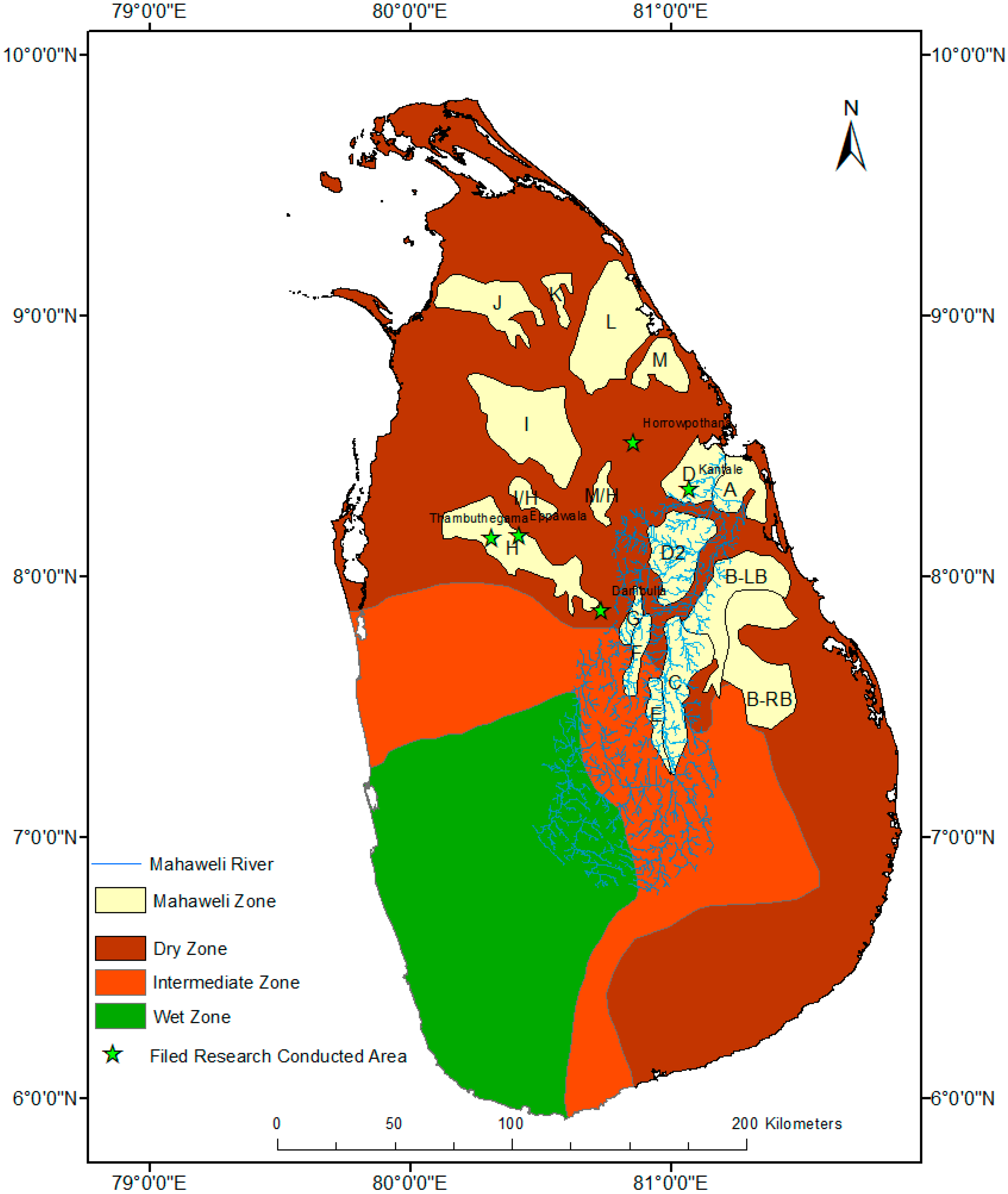
3. Materials and Methods


| Category of Stakeholder | Institution 1 |
|---|---|
| Agricultural administrative sector | - Mahaweli Authority, divisional branches |
| - Divisional Agrarian Office | |
| - Divisional Irrigational Office | |
| - Water Project Field Office | |
| - Central Environmental Authority regional office | |
| - Paddy Board regional office | |
| Non-agricultural administrative office | - Divisional Health Office |
| - Divisional Administrative Offices | |
| - Public Health Inspector Office | |
| - Local council administrative and technical officers (secretaries, maintenance, development and welfare officers) | |
| - Village Officers (Grama Niladari) | |
| Political representation | - Provincial council representatives |
| - Local council members | |
| - Political party activists | |
| - Village-based representatives | |
| Academics or other regional experts | - Researchers |
| - Village-based school teachers | |
| - Regional media reporters | |
| Non-government organization | - World Vision |
| - RECDO (Rural Economic and Community Development Organization) | |
| Community based group or individuals | - Religious leaders or representatives at village level |
| - Farmers | |
| - Fishermen | |
| - Livestock sector | |
| - Retail sellers |
4. Results and Discussion

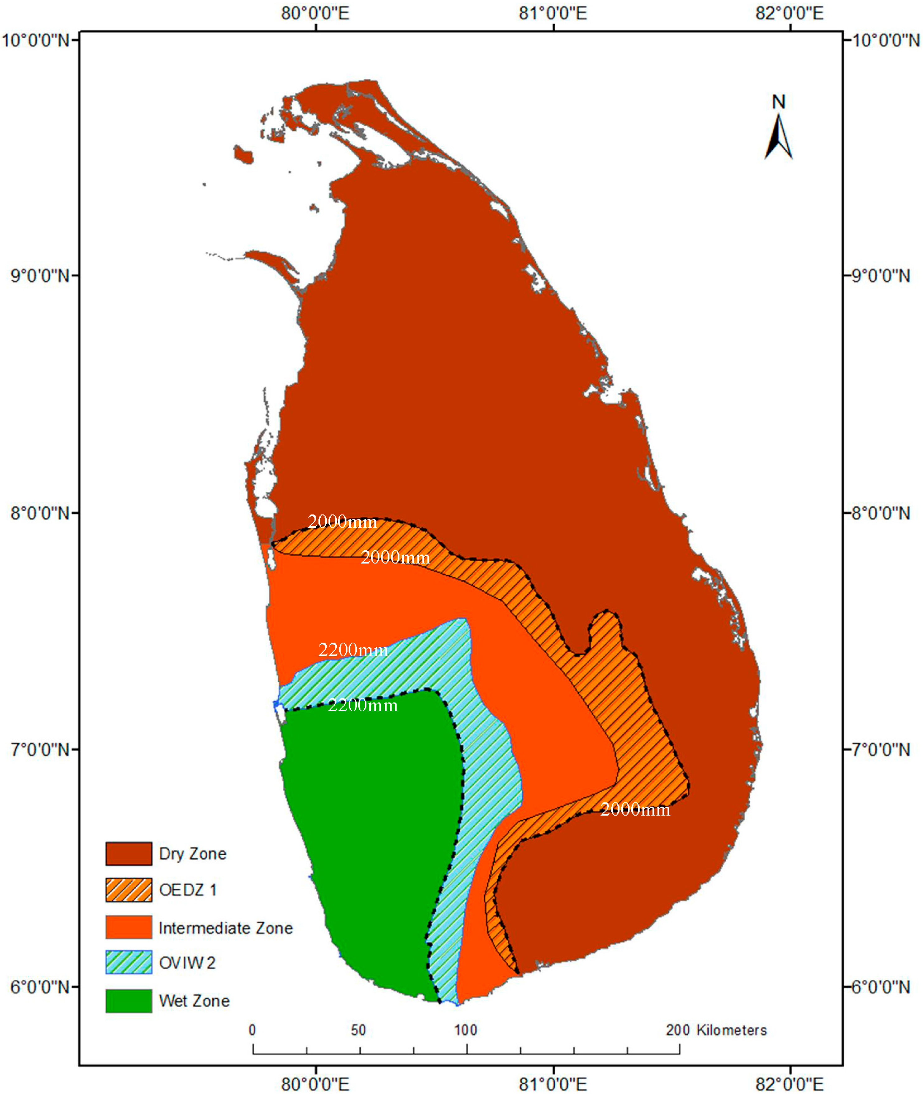
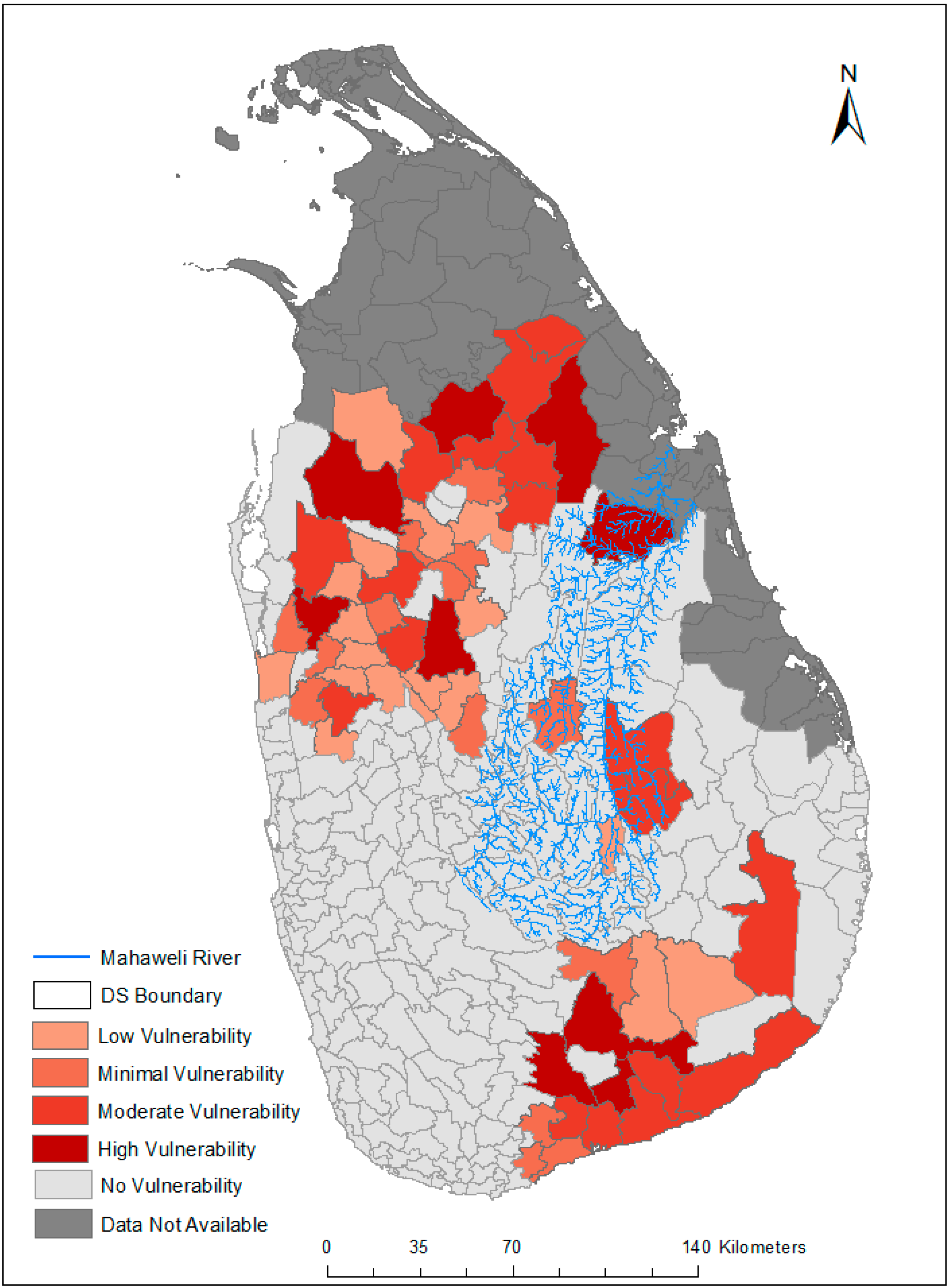
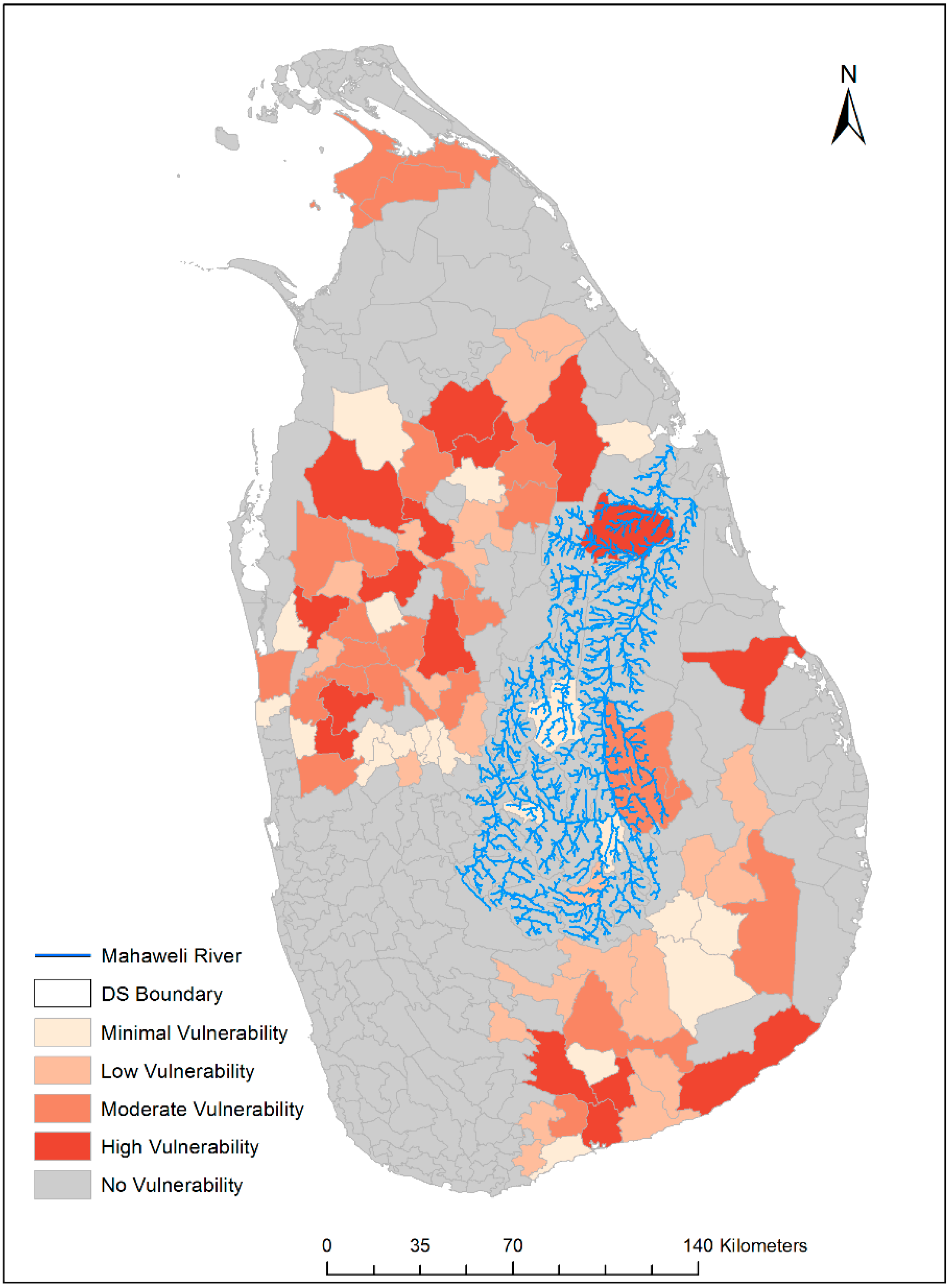
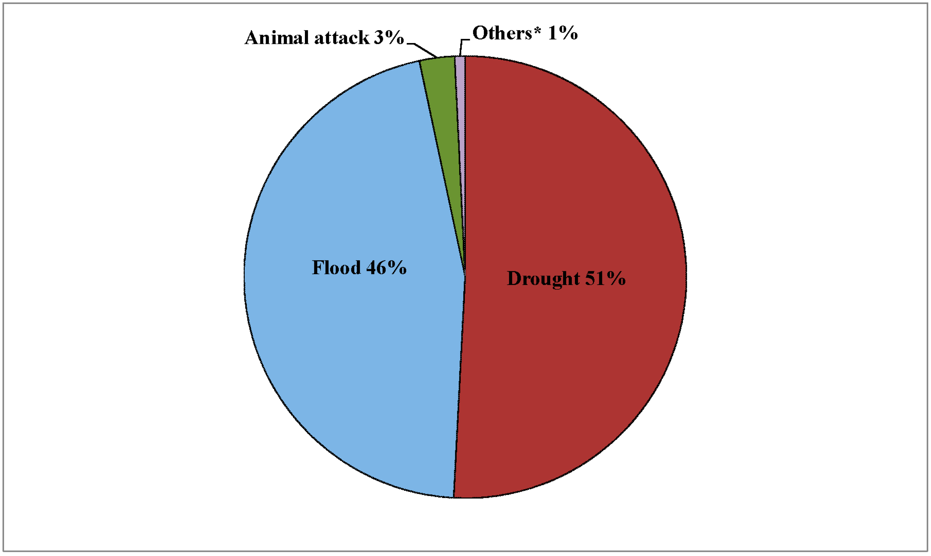
4.1. Spatial and Temporal Climate Change and Uncertainty in Weather Systems
4.1.1. Climate Scientific Observations and Predictions
4.1.2. Traditional Knowledge in Climate Change and Uncertainty in Weather Systems
| Research Location 1 | Responses (Coded) | |||||
|---|---|---|---|---|---|---|
| Extended Long- and Short-Term Drought | Unexpected Flooding | Changing of Usual Seasonal Cultivation System | Lack of Water Supply for Agriculture | Losses of Paddy Harvest | Disregarding of Traditional Knowledge in Water Management | |
| Eppawala | √ | √ | √ | √ | √ | √ |
| Thambuthegama | √ | √ | √ | √ | √ | √ |
| Horrowpothana | √ | √ | √ | √ | √ | √ |
| Kantale | √ | - | √ | √ | √ | √ |
| Dambulla | √ | - | √ | √ | √ | √ |
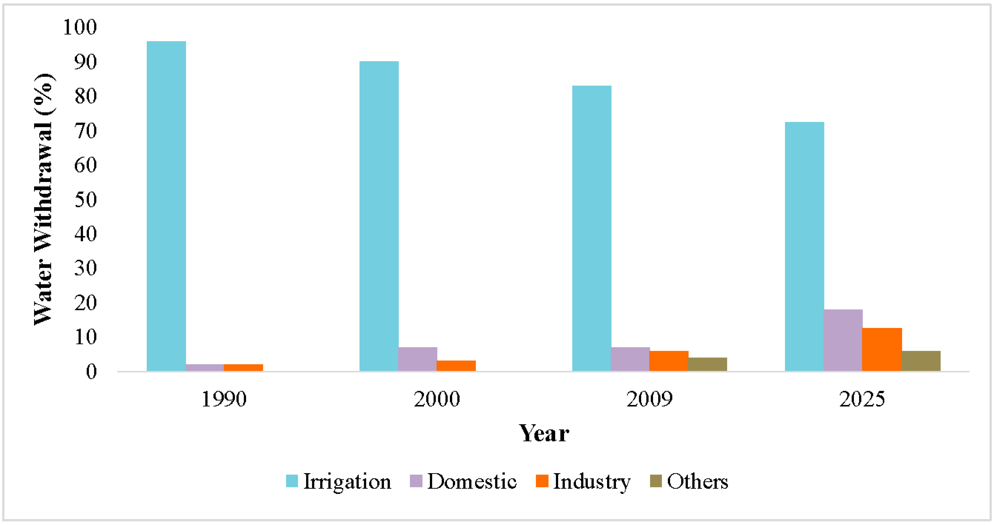
4.2. Water-Climate-Energy-Food Nexus in Competing Interests of Scale (Re) Configuration
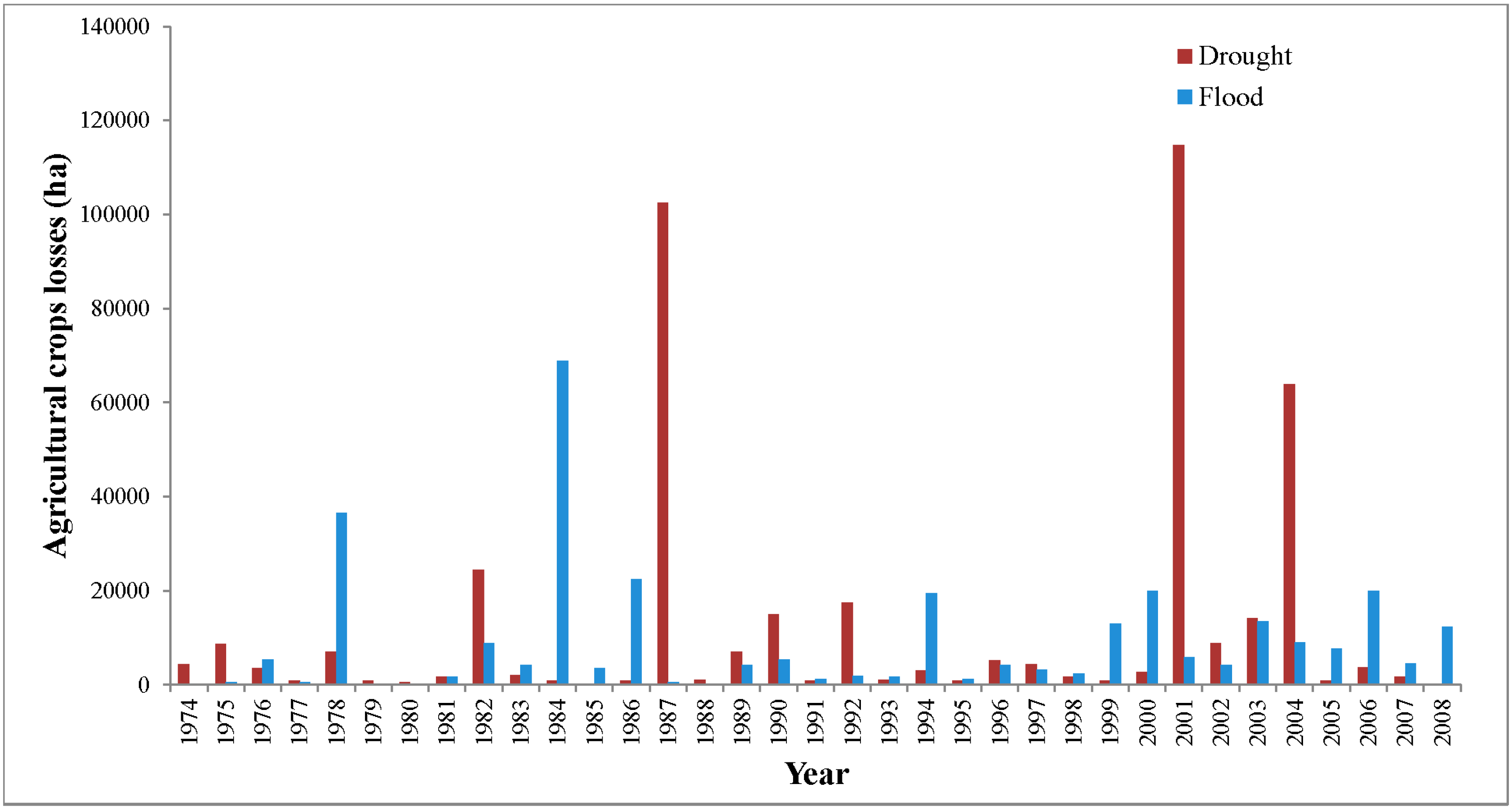
4.3. Impacts of Seasonal and Temporal Climate Change on Paddy Cultivation
4.4. Modern and Traditional Application in Irrigational Water Management

5. Conclusions
Acknowledgments
Author Contributions
Conflicts of Interest
References
- Pahl-Wostl, C. The implications of complexity for integrated resources management. Environ. Modell. Softw. 2007, 22, 561–569. [Google Scholar] [CrossRef]
- Lebel, L. The politics of scale in environmental assessment. In Bridging Scales and Knowledge Systems: Concepts and Applications in Ecosystem Assessment; Reid, W.V., Berkes, F., Wilbanks, T.J., Capistrano, D., Eds.; Island Press: New York, NY, USA, 2006; pp. 37–57. [Google Scholar]
- Loucks, D.P.; van Beek, E.; Stedinger, J.R.; Dijkman, J.P.M.; Villars, M.T. Water resources planning and management: An overview. In Water Resources System Planning and Management: An Introduction to Methods, Models and Applications; UNESCO: Paris, France, 2005; pp. 3–36. [Google Scholar]
- Termeer, C.J.A.M.; Dewulf, A.; Van Lieshout, M. Disentangling scale approaches in governance research: Comparing monocentric, multilevel, and adaptive governance. Ecol. Soc. 2010, 15, 29. [Google Scholar]
- Ministry of Environment-Sri Lanka. Climate Change Vulnerability Data Book; Ministry of Environment: Colombo, Sri Lanka, 2011. [Google Scholar]
- Moldenhauer, K.; Slaton, N. Rice growth and development. In Rice Production Handbook; Slaton, N.A., Ford, L.B., Bernhardt, J.L., Cartwright, R.D., Gardisser, D., Gibbons, J., Huitink, G., Koen, B., Lee, F.N., Miller, D.M., et al., Eds.; Cooperative Extension Service, Division of Agriculture, University of Kansas: Lawrence, KS, USA, 2004; pp. 7–14. [Google Scholar]
- Elakanda, S. Resource-based development: Experience from Mahaweli. In CRBOM Small Publications Series No. 29; Centre for River Basin Organizations and Management: Central Java, Indonesia, 2010; pp. 1–9. [Google Scholar]
- Warner, J.; Wester, P.; Bolding, A. Going with the flow: River basins as the natural units for water management? Water Policy 2008, 10, 121–138. [Google Scholar] [CrossRef]
- Gibson, C.C.; Ostrom, E.; Ahn, T.K. The concept of scale and the human dimensions of global change: A survey. Ecol. Econ. 2000, 32, 217–239. [Google Scholar] [CrossRef]
- Cash, D.W.; Adger, W.F.; Berkes, P.; Garden, L.; Lebel, P.; Olsson, L.; Pritchard, O.Y. Scale and cross-scale dynamics: Governance and information in a multilevel world. Ecol. Soc. 2006, 11, 8. [Google Scholar]
- Pahl-Wostl, C. Transitions towards adaptive management of water facing climate and global change. Water Recour. Manag. 2007, 21, 49–62. [Google Scholar] [CrossRef]
- Kok, K.; Veldkamp, T. Scale and governance: Conceptual considerations and practical implications. Ecol. Soc. 2011, 16, 29–45. [Google Scholar]
- Adger, W.N.; Arnell, N.W.; Tompkins, E.L. Successful adaptation to climate change across scales. Glob. Environ. Change 2005, 15, 77–86. [Google Scholar] [CrossRef]
- WWAP (World Water Assessment Programme). The United Nations World Water Development Report 4: Managing Water under Uncertainty and Risk; UNESCO: Paris, France, 2012. [Google Scholar]
- Molle, F.; Wester, P.; Hirsch, P.; Jensen, J.R.; Murray-Rust, H.; Paranjpye, V.; Pollard, S.; Van der Zaag, P. River basin development and management. In Water for Food and Water for Life; Molden, D., Ed.; International Water Management Institute (IWMI): Colombo, Sri Lanka, 2007; pp. 585–624. [Google Scholar]
- Van Lieshout, M.; Dewulf, A.; Aarts, N.; Termeer, C. Do scale frames matter? Scale frame mismatches in the decision making process about a “mega farm” in a small Dutch village. Ecol. Soc. 2011, 16, 38–53. [Google Scholar]
- Leibold, M.A.; Holyoak, M.; Mouquet, N.; Amarasekare, P.; Chase, J.M.; Hoopes, M.F.; Gonzalez, A. The metacommunity concept: A framework for multi-scale community ecology. Ecol. Lett. 2004, 7, 601–613. [Google Scholar] [CrossRef]
- Swyngedouw, E. Place, Nature and the Question of Scale: Interrogating the Production of Nature; Discussion Paper 5; Brandenburgische Akademie der Wissenschaften: Berlin, Germany, 2010; pp. 5–29. [Google Scholar]
- Swyngedouw, E. The political economy and political ecology of the hydro-social cycle. J. Contemp. Water Res. Educ. 2009, 142, 56–60. [Google Scholar] [CrossRef]
- Lebel, L.; Garden, P.; Imamura, M. The politics of scale, position, and place in the governance of water resources in the Mekong region. Ecol. Soc. 2005, 10, 32–58. [Google Scholar]
- Dore, J.; Lebel, L. Deliberation and scale in Mekong Region water governance. Environ. Manag. 2010, 46, 60–80. [Google Scholar] [CrossRef]
- Moss, T.; Newig, J. Multilevel water governance and problems of scale: Setting the stage for a broader debate. Environ. Manag. 2010, 46. [Google Scholar] [CrossRef]
- Withanachchi, S.S.; Houdret, A.; Nergui, S.; Gonzalez, E.E.I.; Tsogtbayar, A.; Ploeger, A. (Re)Configuration of Water Resources Management in Mongolia: A Critical Geopolitical Analysis; International Center for Development and Decent Work (ICDD): Kassel, Germany, 2014. [Google Scholar]
- De Silva, C.S.; Weatherhead, E.K.; Knox, J.W.; Rodriguez-Diaz, J.A. Predicting the impacts of climate change—A case study of paddy irrigation water requirements in Sri Lanka. Agric. Water Manag. 2007, 93, 19–29. [Google Scholar] [CrossRef]
- Jayawardanaa, D.T.; Pitawalab, H.M.T.G.A.; Ishigaa, H. Groundwater quality in different climatic zones of Sri Lanka: Focus on the occurrence of fluoride. Int. J. Environ. Sci. Dev. 2010, 1, 244–250. [Google Scholar] [CrossRef]
- Creswell, J.W.; Clark, V.L.P. Designing and Conducting Mixed Methods Research; Sage Publication: London, UK, 2007. [Google Scholar]
- Hesse-Biber, S.N. Mixed Methods Research: Merging Theory with Practice; Guilford Press: London, UK, 2010. [Google Scholar]
- Thompson, P. Voice of the Past: Oral History; Oxford University Press: Oxford, UK, 2000. [Google Scholar]
- Conway, D. Managing water in the Ruaha River Basin: The role of climate variability and risk. In Proceedings of the 2005 East African Integrated River Basin Management Conference, Morogoro, Tanzania, 7–9 March 2005; pp. 420–427.
- Keskinen, M.; Chinvanno, S.; Kummu, M.; Nuorteva, P.; Snidvongs, A.; Varis, O.; Västilä, K. Climate change and water resources in the Lower Mekong River Basin: Putting adaptation into the context. J. Water Clim. Change 2010, 1, 103–117. [Google Scholar] [CrossRef]
- Lovell, C.; Mandondo, A.; Moriarty, P. The question of scale in integrated natural resource management. In Integrated Natural Resource Management. Linking Productivity, the Environment and Development; Campbell, B.M., Sayer, J., Eds.; CABI: Wallingford, UK, 2003; pp. 109–136. [Google Scholar]
- Domroes, M.; Schaefer, D. Trends of recent temperature and rainfall changes in Sri Lanka. In Proceedings of 2000 International Conference on Climate Change and Variability, Tokyo, Japan, 13–17 September 2000; pp. 197–204.
- Zubair, L.; Siriwardhana, M.; Chandimala, J.; Yahiya, Z. Predictability of Sri Lankan rainfall based on ENSO. Int. J. Climatol. 2008, 28, 91–101. [Google Scholar] [CrossRef]
- Manawadu, L.; Fernando, N. Climate Changes in Sri Lanka; Department of Meteorology, Sri Lanka: Colombo, Sri Lanka, 2008. [Google Scholar]
- Muththuwatta, L.P.; Liyanage, P.K.N.C. Climate Change Models Shift Boundaries of Agro-Ecological Zones in Sri Lanka. Available online: http://climatenet.blogspot.de/2013/09/climate-change-models-shift-boundaries.html (accessed on 10 July 2014).
- Shantha, W.W.A.; Jayasundara, J.M.S.B. Study on changes of rainfall in the Mahaweli Upper Watershed in Sri Lanka due to climatic changes and develop a correction model for global warming. In Proceedings of the 2005 International Symposium on the Stabilisation of Greenhouse Gas Concentrations, Exeter, UK, 1–3 February 2005.
- Eriyagama, N.; Smakhtin, V.; Chandrapala, L.; Fernando, K. Impacts of Climate Change on Water Resources and Agriculture in Sri Lanka: A Review and Preliminary Vulnerability Mapping; IWMI Research Report 135; International Water Management Institute: Colombo, Sri Lanka, 2010. [Google Scholar]
- Cruz, R.V.; Harasawa, H.; Lal, M.; Wu, S.; Anokhin, Y.; Punsalmaa, B.; Honda, Y.; Jafari, M.; Li, C.; Huu Ninh, N. Asia. In Climate Change 2007: Impacts, Adaptation and Vulnerability; Parry, M.L., Canziani, O.F., Palutikof, J.P., Van der Linden, P.J., Hanson, C.E., Eds.; Cambridge University Press: Cambridge, UK, 2007; pp. 469–506. [Google Scholar]
- Ministry of Finance and Planning, Sri Lanka. Economic Perspective: Sri Lanka. In Annual Report 2012; Ministry of Finance and Planning, Sri Lanka: Colombo, Sri Lanka, 2012; pp. 19–48. [Google Scholar]
- IPCC. Summary for policymakers. In Climate Change 2014: Impacts, Adaptation, and Vulnerability. Part A: Global and Sectoral Aspects. Contribution of Working Group II to the Fifth Assessment Report of the Intergovernmental Panel on Climate Change; Field, C.B., Barros, V.R., Dokken, D.J., Mach, K.J., Mastrandrea, M.D., Bilir, T.E., Chatterjee, M., Ebi, K.L., Estrada, Y.O., Genova, R.C., et al., Eds.; Cambridge University Press: Cambridge, UK, 2014; pp. 1–32. [Google Scholar]
- Jayawardene, H.K.W.I.; Sonnadara, D.U.J.; Jayewardene, D.R. Trends of rainfall in Sri Lanka over the last century. Sri Lankan J. Phys. 2005, 6, 7–17. [Google Scholar]
- Zubair, L. ENSO influences on Mahaweli Stream flow in Sri Lanka. Int. J. Climatol. 2003, 23, 91–102. [Google Scholar]
- Dharmaratne, G.H.P. Impact of changing weather patterns. Vidurava 2005, 22, 9–13. [Google Scholar]
- Riedlinger, D.; Berkes, F. Contributions of traditional knowledge to understanding climate change in the Canadian Arctic. Polar Record 2001, 37, 315–328. [Google Scholar] [CrossRef]
- Nyong, A.; Adesina, F.; Elasha, B.O. The value of indigenous knowledge in climate change mitigation and adaptation strategies in the African Sahel. Mitig. Adapt. Strat. Glob. Change 2007, 12, 787–797. [Google Scholar] [CrossRef]
- David, W.; Ploeger, A. Indigenous Knowledge (IK) of water resources management in West Sumatra, Indonesia. Fut. Food: J. Food Agric. Soc. 2014, 2, 52–60. [Google Scholar]
- Byg, A.; Salick, J. Local perspectives on a global phenomenon—Climate change in Eastern Tibetan villages. Glob. Environ. Change 2009, 19, 156–166. [Google Scholar] [CrossRef]
- Mahaweli Authority. Performance-2012 and Investment Plan–2013, Performance Report up to August-2012; Planning and Monitoring Unit in Mahaweli Authority: Colombo, Sri Lanka, 2012. [Google Scholar]
- The Disaster Management Centre (DMC) of the Ministry of Disaster Management. Sri Lanka National Report on Disaster Risk, Poverty and Human Development Relationship; The Disaster Management Centre (DMC) of the Ministry of Disaster Management: Colombo, Sri Lanka, 2014. [Google Scholar]
- Mahaweli Authority. Mahaweli Hand Book (Statistical Hand Book) 2011–2012; Planning and Monitoring Unit in Mahaweli Authority: Colombo, Sri Lanka, 2012. [Google Scholar]
- Parliament of Sri Lanka. Mahaweli Authority Parliament—Act No. 23 of 1979; Parliament of Sri Lanka: Sri Jayawardenapura, Sri Lanka, 1979. [Google Scholar]
- Hettige, S.T. Socioeconomic issues relating to sustainability of the mahaweli upper catchment Sri Lankan. J. Soc. Sci. 1997, 20, 43–62. [Google Scholar]
- Lakshman, W.D.; Tisdell, C.A. Introduction to Sri Lanka’s development since independence. In Sri Lanka’s Development Since Independence: Socio-Economic Perspectives and Analyses; Nova Science Publishers Inc.: New York, NY, USA, 2000; pp. 1–22. [Google Scholar]
- Haturusinha, R.L.; Theivasagayam, K.; Perera, D.T.D. Water and sanitation for Mahaweli. In Proceedings of the 1994 WEDC Conference, Colombo, Sri Lanka, 22–26 August 1994; pp. 242–245.
- Wettasinha, C. Scaling up participatory development in agricultural settlements. Leisa. Mag. 2001, 39–42. [Google Scholar]
- Perera, G.D.; Sennema, B. Towards sustainable development in Mahaweli Settlements through farmer participation. In Participatory Technology Development Working Paper 6; Diop, J.-M., Waters-Bayer, A., Eds.; Ecoculture Netherlands and Mahaweli Authority: Colombo, Sri Lanka, 2002; pp. 1–23. [Google Scholar]
- Hewawasam, T. Effect of land use in the upper Mahaweli catchment area on erosion, landslides and siltation in hydropower reservoirs of Sri Lanka. J. Nat. Sci. Found. Sri Lanka 2010, 38, 3–14. [Google Scholar]
- Lezama Escalante, C. A Cultural approach to water management policies. In Five Years of EXCEED. Sustainable Water Management in Developing Countries; Bahadir, M., Haarstrick, A., Eds.; Technische Universität Braunschweig: Braunschweig, Germany, 2014; pp. 256–265. [Google Scholar]
- AQUASTAT. Available online: http://www.fao.org/nr/water/aquastat/main/index.stm (accessed on 20 October 2014).
- AWWAP (United Nations World Water Assessment Programme). The United Nations World Water Development Report: Water and Energy; UNESCO: Paris, France, 2014. [Google Scholar]
- Bastiaassen, W.G.M.; Chandrapala, L. Water balance availability across Sri Lanka for assessing agricultural and environmental water use. Agric. Water Manag. 2003, 58, 171–192. [Google Scholar] [CrossRef]
- Central Bank of Sri Lanka. Annual Report 2012; Central Bank of Sri Lanka: Colombo, Sri Lanka, 2012. [Google Scholar]
- Central Bank of Sri Lanka. Annual Report 2011; Central Bank of Sri Lanka: Colombo, Sri Lanka, 2011. [Google Scholar]
- Wickremasekara, D. Paddy Cultivation Slashed; Rice to be Imported. Available online: http://www.sundaytimes.lk/140406/news/paddy-cultivation-slashed-rice-to-be-imported-91848.html (accessed on 20 July 2014).
- Malmgren, B.A.; Hulugalla, R.; Hayashi, Y.; Mikami, T. Precipitation trends in Sri Lanka since the 1870s and relationships to El Niño—Southern oscillation. Int. J. Climatol. 2003, 23, 1235–1252. [Google Scholar] [CrossRef]
- Niranjan, F.; Jayatilaka, W.; Singh, N.P.; Bantilan, M.C.S. Mainstreaming Grassroots Adaptation and Building Climate Resilient Agriculture in Sri Lanka; Policy Brief No. 20; International Crops Research Institute for the Semi-Arid Tropics: Hyderabad, India, 2013. [Google Scholar]
- Matthews, R.B.; Kropff, M.J.; Horie, T.; Bachelet, D. Simulating the impact of climate change on rice production in Asia and evaluating options for adaptation. Agric. Syst. 1997, 54, 399–425. [Google Scholar] [CrossRef]
- Welch, J.R.; Vincent, J.R.; Auffhammer, M.; Moya, P.F.; Dobermann, A.; Dawe, D. Rice yields in tropical/subtropical Asia exhibit large but opposing sensitivities to minimum and maximum temperatures. Proc. Natl. Acad. Sci. USA 2010, 107, 14562–14567. [Google Scholar] [CrossRef] [PubMed]
- Sri Lanka Disaster Knowledge Network. Disaster Profile of Sri Lanka. Available online: http://www.saarc-sadkn.org/countries/srilanka/disaster_profile.aspx (accessed on 10 October 2014).
- Geekiyanage, N.; Pushpakumara, D.K.N.G. Ecology of ancient Tank Cascade Systems in island Sri Lanka. J. Mar. Island Cult. 2013, 2, 93–101. [Google Scholar] [CrossRef]
- Madduma Bandara, C.M. Tank cascade systems in Sri Lanka: Some thoughts on their development implications. In Summaries of Papers Presented at Irrigation Research Management Unit Seminar Series during 1994; Haq, K.A., Wijayaratne, C.M., Samarasekera, B.M.S., Eds.; IIMI (International Irrigation Management Institute): Colombo, Sri Lanka, 1995; p. 14. [Google Scholar]
- Schütt, B.; Bebermeier, W.; Meister, J.; Withanachchi, C.R. Characterisation of the Rota Wewa tank cascade system in the vicinity of Anuradhapura, Sri Lanka. J. Geogr. Soc. Berl. 2013, 144, 51–68. [Google Scholar]
- Withanachchi, C.R. Hydro-technology in dry zone irrigation management of ancient Sri Lanka and its potential benefits for the world the international conference on Traditional Knowledge for Water Resource Management (TKWRM). In Proceedings of the 2012 International Center on Qanats and Historic Hydraulic Structure (ICQHS), Yazd, Iran, 21–23 February 2012; pp. 1–7.
- Panapitiya, M. “Inconvenient Truth” behind engineering designs of irrigation projects developed during the last century. Econ. Rev. Peopl. Bank Colombo 2010, 36, 16–20. [Google Scholar]
- Gunawardena, E.R.N. Operationalizing IWRM Through River Basin Planning and Management. Available online: http://tinyurl.com/ky53p9p (accessed on 5 October 2013).
- Merrey, D.J. Potential for devolution of management to farmers’ organizations in an hierarchical irrigation management agency: The case of the Mahaweli Authority of Sri Lanka. In The Blurring of a Vision—The Mahaweli: Its Social, Economic and Political Implications; Müller, H.P., Hettige, S.T., Eds.; Sarvodaya Publication: Ratmalana, Sri Lanka, 1995; pp. 222–243. [Google Scholar]
- Müller, H.P.; Hettige, S.T. Introduction the Mahaweli-The Blurring of a Vision. In The Blurring of a Vision—The Mahaweli: Its Social, Economic and Political Implications; Müller, H.P., Hettige, S.T., Eds.; Sarvodaya Publication: Ratmalana, Sri Lanka, 1995; pp. 1–22. [Google Scholar]
- Mollinga, P.P. The water resources policy process in India: Centralization, polarization and new demands on governance. In Governance of Water: Institutional alternatives and Political Economy; Ballabh, V., Ed.; Sage: New Delhi, India, 2008; pp. 339–370. [Google Scholar]
- Wijesekera, N.T.S.; Wickramaarachchi, T.N. Reality of irrigation water use and suggestions for better management: A comparison of two schemes from Sri Lanka. Water Sci. Technol. 2003, 48, 197–206. [Google Scholar] [PubMed]
© 2014 by the authors; licensee MDPI, Basel, Switzerland. This article is an open access article distributed under the terms and conditions of the Creative Commons Attribution license (http://creativecommons.org/licenses/by/4.0/).
Share and Cite
Withanachchi, S.S.; Köpke, S.; Withanachchi, C.R.; Pathiranage, R.; Ploeger, A. Water Resource Management in Dry Zonal Paddy Cultivation in Mahaweli River Basin, Sri Lanka: An Analysis of Spatial and Temporal Climate Change Impacts and Traditional Knowledge. Climate 2014, 2, 329-354. https://doi.org/10.3390/cli2040329
Withanachchi SS, Köpke S, Withanachchi CR, Pathiranage R, Ploeger A. Water Resource Management in Dry Zonal Paddy Cultivation in Mahaweli River Basin, Sri Lanka: An Analysis of Spatial and Temporal Climate Change Impacts and Traditional Knowledge. Climate. 2014; 2(4):329-354. https://doi.org/10.3390/cli2040329
Chicago/Turabian StyleWithanachchi, Sisira S., Sören Köpke, Chandana R. Withanachchi, Ruwan Pathiranage, and Angelika Ploeger. 2014. "Water Resource Management in Dry Zonal Paddy Cultivation in Mahaweli River Basin, Sri Lanka: An Analysis of Spatial and Temporal Climate Change Impacts and Traditional Knowledge" Climate 2, no. 4: 329-354. https://doi.org/10.3390/cli2040329
APA StyleWithanachchi, S. S., Köpke, S., Withanachchi, C. R., Pathiranage, R., & Ploeger, A. (2014). Water Resource Management in Dry Zonal Paddy Cultivation in Mahaweli River Basin, Sri Lanka: An Analysis of Spatial and Temporal Climate Change Impacts and Traditional Knowledge. Climate, 2(4), 329-354. https://doi.org/10.3390/cli2040329