Assessing Coastal Vulnerability to Sea Level Rise in Qatar: An Index-Based Approach Using Analytic Hierarchy Process
Abstract
1. Introduction
2. Methodology and Data
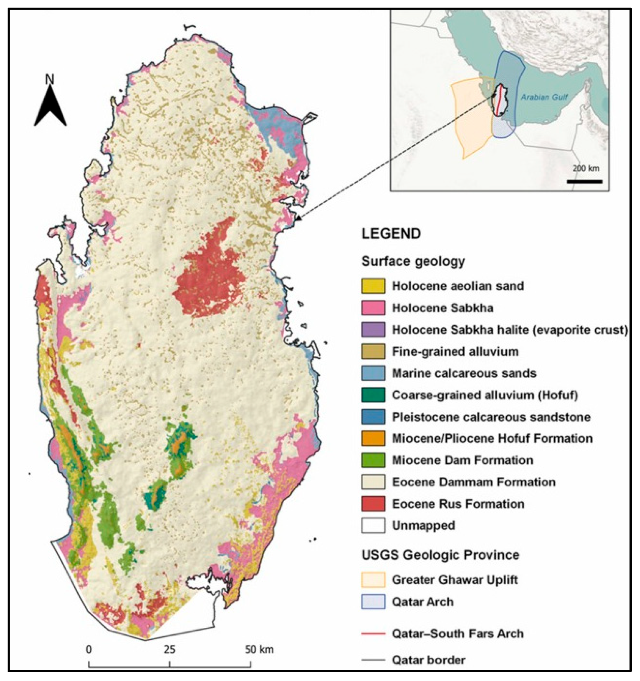
2.1. Study Area
2.2. The Coastal Vulnerability Index (CVI)
- a = geomorphology.
- b = coastal slope.
- c = relative sea-level rise rate.
- d = shoreline erosion/accretion rate.
- e = mean tide range.
- f = mean wave height.
- g = population density.
- h = land use.
- i = GDP per capita.
| Variable | Definition & Data Source |
|---|---|
| Relative SLR rate | The observed increase in sea level relative to the land, considered both the sea level change and vertical movement (land subsidence). [21] |
| Geomorphology | The physical structure and composition of the coastline, which determines the resilience to coastal hazards. [38,46,47] |
| Coastal Slope | The gradient of the coastal land surface, determining inland water penetration capabilities. Shuttle Radar Topography Mission (SRTM) 30 m, (https://earthexplorer.usgs.gov/) (accessed on 10 October 2024) |
| Shoreline Erosion/Accretion Rate | The rate at which the shoreline is changing, whether it is retreating or advancing due to natural or artificial processes. Landsat-8 Data (https://earthexplorer.usgs.gov/) (accessed on 10 October 2024) |
| Mean Tide Range | The average vertical difference between low and high tides across certain key locations. Qatar Meteorology Department (https://qweather.gov.qa/CAA/Index.aspx) (accessed on 24 August 2024) |
| Mean Wave Height | The average height of waves reaching the shoreline across certain key locations. Qatar Meteorology Department (https://qweather.gov.qa/CAA/Index.aspx) (accessed on 24 August 2024) |
| Population Density | The number of people residing per square kilometer along the coastline. [48] |
| Land Use | The classification of coastal areas based on order of importance in cases of coastal hazards. Landsat-8 Data (https://earthexplorer.usgs.gov/) (accessed on 10 October 2024) [47] |
| Gross Domestic Product (GDP) | An economic indicator reflecting the average income of Qatar, which demonstrates the capacity of a country to adapt and respond to coastal hazards. [49] |
| Variable | Very Low (1) | Low (2) | Moderate (3) | High (4) | Very High (5) |
|---|---|---|---|---|---|
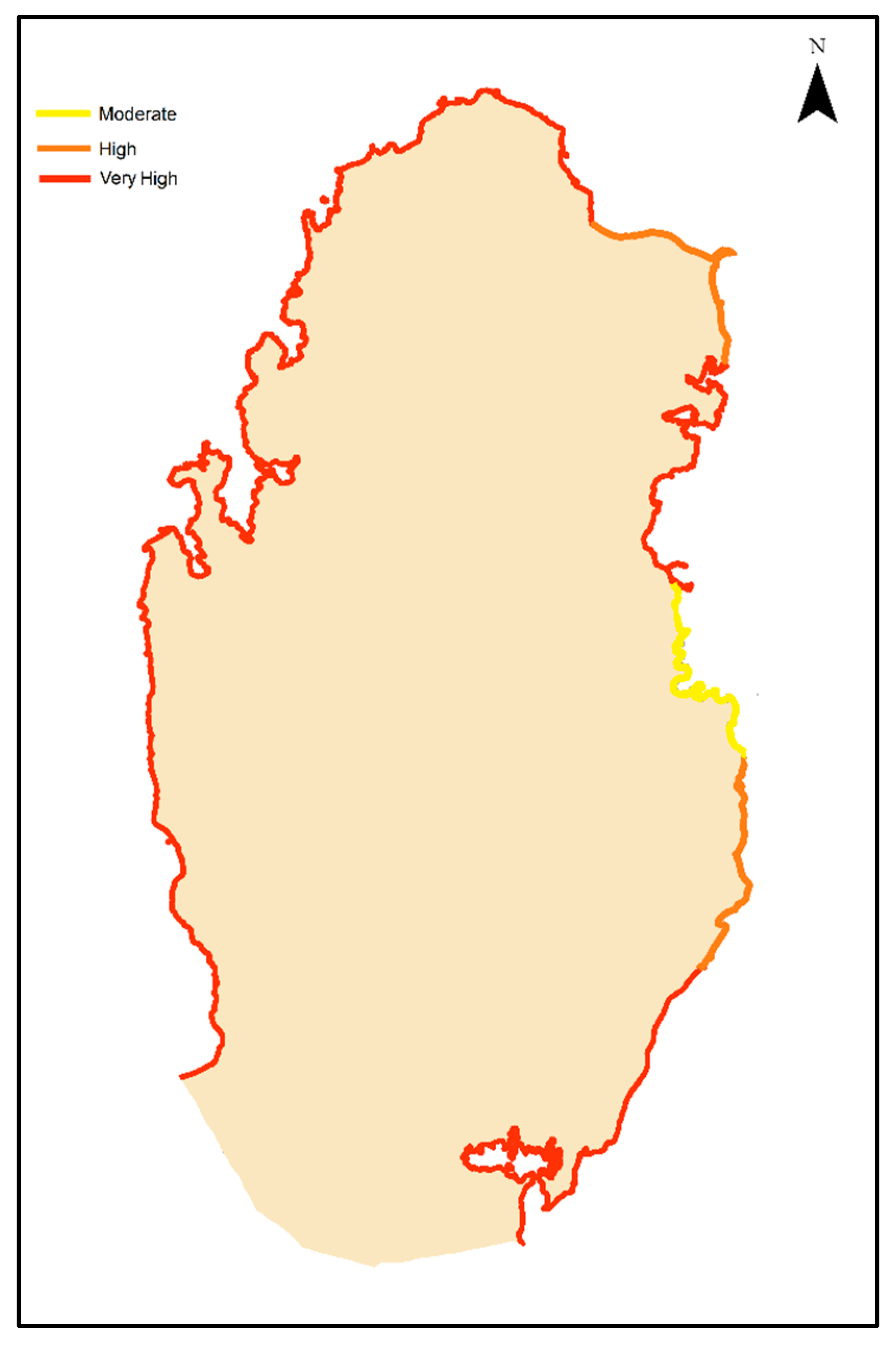
| Geomorphology | Rocky Cliffs | Indented Coasts Medium Cliffs | Low Cliffs | Cobble Beaches Lagoon | Mangroves Sand beaches Mud Flats Deltas |
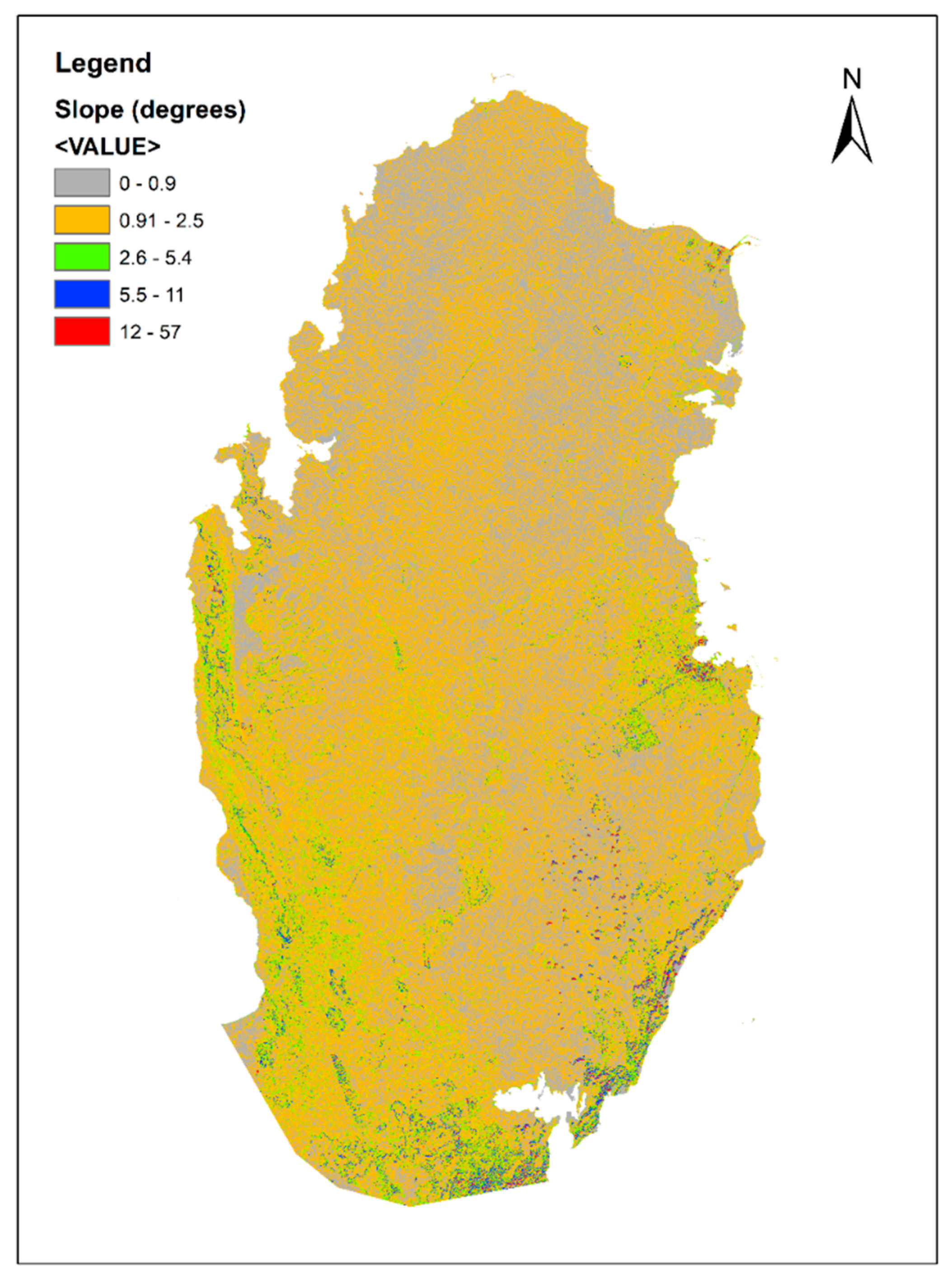
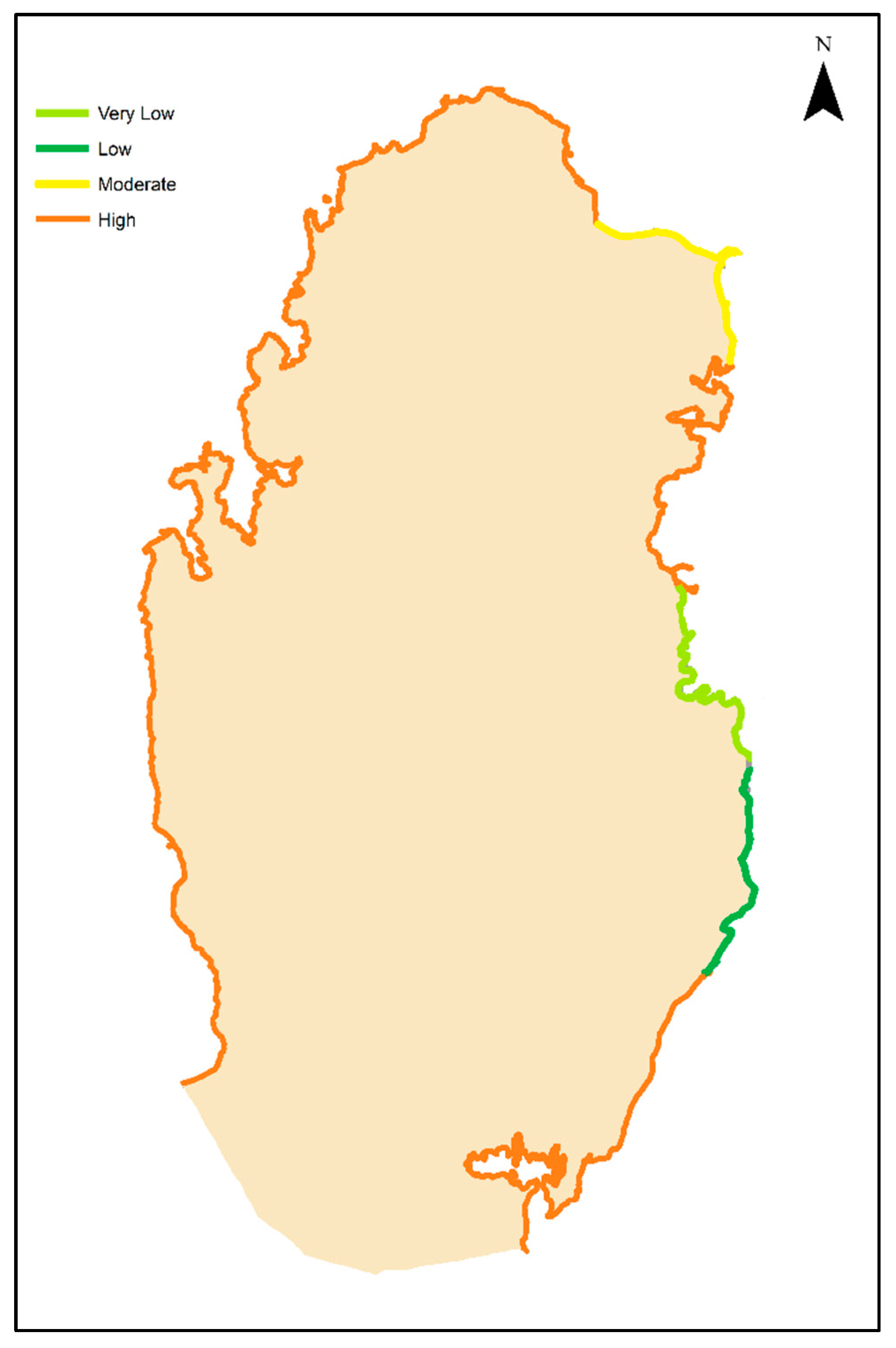
| Coastal Slope (%) | >36 | 22–36 | 10–22 | 5–10 | <5 |
| Relative SLR Rate (mm/yr) | <1.5 | 1.5–2.5 | 2.5–3.0 | 3.0–3.16 | >3.16 |
| Shoreline Erosion/Accretion Rate (m/yr) | Accretion >10 | Accretion <10 | Stable | Erosion <5 | Erosion >5 |
| Mean Tide Range (m) | 1.48–1.68 | 1.68–1.80 | 1.80–2.02 | 2.02–2.11 | 2.11–2.74 |
| Mean Wave Height (m) | <0.5 | 0.5–0.8 | 0.8–1.0 | 1.0–1.1 | >1.1 |
| Population Density (people/km2) | <150 | 151–300 | 301–500 | 501–1000 | >1000 |
| Land Use | Undeveloped land No ecological hotspots | Coastal areas | Agriculture Preservations | Urban development | Industrial development |
| GDP (billion) (USD) | >471.40 | 471.40–72.85 | 72.84–18.90 | 18.89–4.95 | <4.94 |
2.3. Analytic Hierarchy Process
2.4. Geomorphology
2.5. Coastal Slope
2.6. Relative Sea Level Rise Rate
2.7. Shoreline Erosion/Accretion Rate
2.8. Mean Tide Range
2.9. Mean Wave Height
3. Results and Discussion
- PVI 75%, SVI 25%
- PVI 50%, SVI 50%
- PVI 25%, SVI 75%
4. Conclusions
Author Contributions
Funding
Data Availability Statement
Acknowledgments
Conflicts of Interest
References
- IPCC. Section 4: Near-Term Responses in a Changing Climate. In Climate Change 2023: Synthesis Report; IPCC: Geneva, Switzerland, 2023; pp. 42–66. [Google Scholar] [CrossRef]
- IPCC. Sea Level Rise and Implications for Low-Lying Islands, Coasts and Communities. In The Ocean and Cryosphere in a Changing Climate; Cambridge University Press: Cambridge, UK, 2022; pp. 321–446. [Google Scholar] [CrossRef]
- Fang, J.Y.; Zhu, J.L.; Wang, S.P.; Yue, C.; Shen, H.H. Global warming, human-induced carbon emissions, and their uncertainties. Sci. China Earth Sci. 2011, 54, 1458–1468. [Google Scholar] [CrossRef]
- Zhong, S.; Huang, C. Climate change and human health: Risks and responses. Kexue Tongbao/Chin. Sci. Bull. 2019, 64, 2002–2010. [Google Scholar] [CrossRef]
- Bakhamis, A.N.; Bilal, H.; Heggy, E.; Al-Kuwari, M.S.; Al-Ansari, T. On the drivers, forecasts, and uncertainties of relative sea level rise in the Eastern Arabian Peninsula: A review. Reg. Stud. Mar. Sci. 2024, 73, 103503. [Google Scholar] [CrossRef]
- Church, J.A.; White, N.J. Sea-Level Rise from the Late 19th to the Early 21st Century. Surv. Geophys. 2011, 32, 585–602. [Google Scholar] [CrossRef]
- Hay, C.C.; Morrow, E.; Kopp, R.E.; Mitrovica, J.X. Probabilistic reanalysis of twentieth-century sea-level rise. Nature 2015, 517, 481–484. [Google Scholar] [CrossRef]
- Frederikse, T.; Landerer, F.W.; Caron, L.; Adhikari, S.; Parkes, D.; Humphrey, V.; Dangendorf, S.; Hogarth, P.; Zanna, L.; Cheng, L.; et al. The causes of sea-level rise since 1900. Nature 2020, 584, 393–397. [Google Scholar] [CrossRef]
- Gornitz, V.; White, T.W.; Cushman, R.M. Vulnerability of the US to Future Sea Level Rise; Oak Ridge National Lab.: Oak Ridge, TN, USA, 1991. [Google Scholar]
- Ramieri, E.; Hartley, A.; Barbanti, A.; Santos, F.D.; Gomes, A.; Hilden, M.; Laihonen, P.; Marinova, N.; Santini, M. Methods for Assessing Coastal Vulnerability to Climate Change; European Environment Agency, European Topic Centre on Climate Change Impacts, Vulnerability and Adaptation: Copenhagen, Denmark, 2011; pp. 1–93. [Google Scholar]
- Pantusa, D.; D’aLessandro, F.; Frega, F.; Francone, A.; Tomasicchio, G.R. Improvement of a coastal vulnerability index and its application along the Calabria Coastline, Italy. Sci. Rep. 2022, 12, 21959. [Google Scholar] [CrossRef]
- Shah, M.A.R.; Wang, X. Assessing social-ecological vulnerability and risk to coastal flooding: A case study for Prince Edward Island, Canada. Int. J. Disaster Risk Reduct. 2024, 106, 104450. [Google Scholar] [CrossRef]
- Fajri, Z.; Beroho, M.; Lamhadri, S.; Ouallali, A.; Spalevic, V.; Aboumaria, K. Geomatics Assessment of Coastal Erosion Vulnerability: A Case Study of Agadir Bay, Morocco. J. Agric. For. 2024, 70, 185–201. [Google Scholar] [CrossRef]
- Sreelakshmi, M.; Balachandran, S.; Abdurazak, F.; Gopinath, G.; Joseph, S. From perils to preparedness: Decoding coastal hazard risks on Kerala’s central coast through the IPCC framework. Nat. Hazards 2024, 120, 8639–8666. [Google Scholar] [CrossRef]
- Das, T.; Shahfahad; Rahman, A. Assessing tropical cyclone risk for improving mitigation strategies in Coastal Odisha, India. Environ. Sci. Pollut. Res. 2024, 31, 53856–53876. [Google Scholar] [CrossRef]
- Xu, J.; Qiang, Y. Environmental justice implications of flood risk in the contiguous United States—A spatiotemporal assessment of flood exposure change from 2001 to 2019. Cartogr. Geogr. Inf. Sci. 2024, 51, 492–512. [Google Scholar] [CrossRef]
- Carbognin, L.; Teatini, P.; Tosi, L. Eustacy and land subsidence in the Venice Lagoon at the beginning of the new millennium. J. Mar. Syst. 2004, 51, 345–353. [Google Scholar] [CrossRef]
- Umgiesser, G.; Bajo, M.; Ferrarin, C.; Cucco, A.; Lionello, P.; Zanchettin, D.; Papa, A.; Tosoni, A.; Ferla, M.; Coraci, E.; et al. The prediction of floods in Venice: Methods, models and uncertainty (review article). Nat. Hazards Earth Syst. Sci. 2021, 21, 2679–2704. [Google Scholar] [CrossRef]
- VanKoningsveld, M.; Mulder, J.P.M.; Stive, M.J.F.; VanDerValk, L.; VanDerWeck, A.W. Living with Sea-Level Rise and Climate Change: A Case Study of the Netherlands. J. Coast. Res. 2008, 242, 367–379. [Google Scholar] [CrossRef]
- Jonkman, S.N.; Hillen, M.M.; Nicholls, R.J.; Kanning, W.; van Ledden, M. Costs of Adapting Coastal Defences to Sea-Level Rise—New Estimates and Their Implications. J. Coast. Res. 2013, 29, 1212–1226. [Google Scholar] [CrossRef]
- NOAA/NESDIS/STAR Laboratory. Center for Satellite Applications and Research—NOAA/NESDIS/STAR. Available online: https://www.star.nesdis.noaa.gov/socd/lsa/SeaLevelRise/LSA_SLR_timeseries_regional.php (accessed on 9 May 2022).
- Khan, A.A.; Ahmed, I.; Qamar, M.K.; Aqsa, T. Sea Level Rise and Tsunami in the Middle East. Asian Bull. Big Data Manag. 2024, 4, 66–87. [Google Scholar] [CrossRef]
- Saaty, T.L. A scaling method for priorities in hierarchical structures. J. Math. Psychol. 1977, 15, 234–281. [Google Scholar] [CrossRef]
- Sethuraman, S.; Alshahrani, H.M.; Tamizhselvi, A.; Sujaatha, A. Assessment of coastal vulnerability using AHP and machine learning techniques. J. South Am. Earth Sci. 2024, 147, 105107. [Google Scholar] [CrossRef]
- Sekovski, I.; Del Río, L.; Armaroli, C. Development of a coastal vulnerability index using analytical hierarchy process and application to Ravenna province (Italy). Ocean Coast. Manag. 2020, 183, 104982. [Google Scholar] [CrossRef]
- Rana, M.; Proshanto, B.; Bashirul, I.; Mostaq, H. A GIS-AHP Technique to Assess the Flood Susceptibility: A Case on Bhola District. In Proceedings of the 7th International Conference on Advances in Civil Engineering (ICACE2024), Chattogram, Bangladesh, 12–14 December 2024. [Google Scholar]
- Cruz-Ramírez, C.J.; Chávez, V.; Silva, R.; Muñoz-Perez, J.J.; Rivera-Arriaga, E. Coastal Management: A Review of Key Elements for Vulnerability Assessment. J. Mar. Sci. Eng. 2024, 12, 386. [Google Scholar] [CrossRef]
- Chang, H.-K.; Liou, J.-C.; Chen, W.-W. Protection Priority in the Coastal Environment Using a Hybrid AHP-TOPSIS Method on the Miaoli Coast, Taiwan. J. Coast. Res. 2012, 28, 369–374. [Google Scholar] [CrossRef]
- Mahapatra, M.; Ramakrishnan, R.; Rajawat, A.S. Coastal vulnerability assessment using analytical hierarchical process for South Gujarat coast, India. Nat. Hazards 2015, 76, 139–159. [Google Scholar] [CrossRef]
- Bera, R.; Maiti, R. Multi hazards risk assessment of Indian Sundarbans using GIS based Analytic Hierarchy Process (AHP). Reg. Stud. Mar. Sci. 2021, 44, 101766. [Google Scholar] [CrossRef]
- Ariffin, E.H.; Mathew, M.J.; Roslee, A.; Ismailluddin, A.; Yun, L.S.; Putra, A.B.; Yusof, K.M.K.K.; Menhat, M.; Ismail, I.; Shamsul, H.A.; et al. A multi-hazards coastal vulnerability index of the east coast of Peninsular Malaysia. Int. J. Disaster Risk Reduct. 2023, 84, 103484. [Google Scholar] [CrossRef]
- Neelamani, S.; Al-Houti, D.; Al-Ragum, A.; Al-Saleh, A.H.; Al-Salem, K. Coastal Vulnerability Index for Kuwaiti Coast. J. Eng. Res. 2022, 10, 1–22. [Google Scholar] [CrossRef]
- Rao, K.N.; Subraelu, P.; Rao, T.V.; Malini, B.H.; Ratheesh, R.; Bhattacharya, S.; Rajawat, A.S. Sea-level rise and coastal vulnerability: An assessment of UAE coast, through remote sensing and GIS. J. Coast. Conserv. 2021, 12, 195–207. [Google Scholar] [CrossRef]
- AR5 Climate Change 2013: The Physical Science Basis—IPCC. Available online: https://www.ipcc.ch/report/ar5/wg1/ (accessed on 6 November 2021).
- Han, W.; Meehl, G.A.; Rajagopalan, B.; Fasullo, J.T.; Hu, A.; Lin, J.; Large, W.G.; Wang, J.-W.; Quan, X.-W.; Trenary, L.L.; et al. Patterns of Indian Ocean sea-level change in a warming climate. Nat. Geosci. 2010, 3, 546–550. [Google Scholar] [CrossRef]
- Dawoud, M.A.; Al Mulla, M.M. Environmental Impacts of Seawater Desalination: Arabian Gulf Case Study. Int. J. Environ. Sustain. 2012, 1, 22–37. [Google Scholar] [CrossRef]
- Pendleton, E.A.; Barras, J.A.; Williams, S.J.; Twichell, D.C. Coastal vulnerability assessment of the Northern Gulf of Mexico to sea-level rise and coastal change. In Vulnerable U.S. Shorelines and Coasts: Select Assessments; US Geological Survey: Reston, VA, USA, 2012; pp. 95–125. [Google Scholar] [CrossRef]
- Al-Hinai, G.A.; Brook, S.S. Geomorphology of Qatar: A Comprehensive Overview. In Remote Sensing of Geomorphology; Springer: Berlin/Heidelberg, Germany, 2017; pp. 53–73. [Google Scholar]
- Bilal, H.; Govindan, R.; Zekri, S.; Al-Maktoumi, A.; Rajabi, M.M.; Triki, C. Geospatial techniques for identifying optimal rainwater harvesting sites to enhance agricultural productivity in hyper arid areas. Agric. Water Manag. 2025, 318, 109696. [Google Scholar] [CrossRef]
- Ministry of Development Planning and Statistics. Available online: https://www.mdps.gov.qa/en/statistics1/StatisticsSite/Pages/default.aspx (accessed on 24 October 2024).
- Gornitz, V.M.; White, T.W.; Daniels, R.C. A Coastal Hazards Data Base for the US East Coast; Carbon Dioxide Information; Oak Ridge National Lab.: Oak Ridge, TN, USA, 1992. [Google Scholar]
- Gornitz, V.M.; Beaty, T.W.; Daniels, R.C. A Coastal Hazards Data Base for the US West Coast. Oak Ridge, Tennessee: National Technical Information Service; Environmental Sciences Division Publication No. 4590, Report ORNL/CDIAC-81, NDP-043C.; Oak Ridge National Lab.: Oak Ridge, TN, USA, 1997. [Google Scholar]
- El-Hattab, M.M. Improving Coastal Vulnerability Index of the Nile Delta Coastal Zone, Egypt. J. Earth Sci. Clim. Change 2015, 6, 293. [Google Scholar] [CrossRef]
- Li, X.; Zhou, Y.; Tian, B.; Kuang, R.; Wang, L. GIS-based methodology for erosion risk assessment of the muddy coast in the Yangtze Delta. Ocean Coast. Manag. 2015, 108, 97–108. [Google Scholar] [CrossRef]
- Batzakis, D.-V.; Karymbalis, E.; Tsanakas, K. Assessing Coastal Vulnerability to Climate Change-Induced Hazards in the Eastern Mediterranean: A Comparative Review of Methodological Approaches; Elsevier Inc.: Amsterdam, The Netherlands, 2024. [Google Scholar] [CrossRef]
- Rivers, J.M.; Larson, K.P. The Cenozoic kinematics of Qatar: Evidence for high-angle faulting along the Dukhan ‘anticline’. Mar. Pet. Geol. 2018, 92, 953–961. [Google Scholar] [CrossRef]
- Aloui, D.; Benkraiem, R.; Guesmi, K.; Mzoughi, H. Managing natural resource prices in a geopolitical risk environment. Resour. Policy 2023, 83, 103628. [Google Scholar] [CrossRef]
- Qatar. Planning and Statistics Authority, Main Results of the General Census of Population, Housing and Establishments. 2020. Available online: https://www.npc.qa/ar/pages/default.aspxReleases/General/Census/Census_2020_Res_Summary_En.pdf (accessed on 24 October 2024).
- Qatar Statistics Authority. Window on Economic Statistics of Qatar; National Planning Council: Doha, Qatar, 2023; Available online: https://www.npc.qa/en/statistics/Statistical%20Releases/Economic/General%20Economic%20Statistics/windowonstatistics/Windows_47th_Issue_Q4_2023_AE.pdf (accessed on 24 October 2024).
- Aloui, S.; Zghibi, A.; Mazzoni, A.; Elomri, A.; Triki, C. Groundwater resources in Qatar: A comprehensive review and informative recommendations for research, governance, and management in support of sustainability. J. Hydrol. Reg. Stud. 2023, 50, 101564. [Google Scholar] [CrossRef]
- Bilal, H.; Govindan, R.; Zekri, S.; Al-Maktoumi, A.; Rajabi, M.M.; Triki, C.; Harrathi, W. Identification of potential managed aquifer recharge sites in hyper-arid environment using GIS and analytical hierarchy process. Appl. Water Sci. 2025, 15, 99. [Google Scholar] [CrossRef]
- Emil, M.K.; Sultan, M.; Alakhras, K.; Sataer, G.; Gozi, S.; Al-Marri, M.; Gebremichael, E. Countrywide monitoring of ground deformation using insar time series: A case study from Qatar. Remote Sens. 2021, 13, 702. [Google Scholar] [CrossRef]
- Engel, M.; Strohmenger, C.J.; Peis, K.T.; Pint, A.; Brill, D.; Brückner, H.; Eberli, G. High-resolution facies analysis of a coastal sabkha in the eastern Gulf of Salwa (Qatar): A spatio-temporal reconstruction. Sedimentology 2022, 69, 1119–1150. [Google Scholar] [CrossRef]
- Carolina, N.; Barzehkar, M.; Parnell, K.; Soomere, T. Incorporating a Machine Learning Approach into an Established Decision Support System for Coastal Vulnerability in the Eastern Baltic Sea. J. Coast. Res. 2024, 113, 58–62. [Google Scholar] [CrossRef]
- Koroglu, A.; Ranasinghe, R.; Jiménez, J.A.; Dastgheib, A. Comparison of Coastal Vulnerability Index applications for Barcelona Province. Ocean Coast. Manag. 2019, 178, 104799. [Google Scholar] [CrossRef]
- Šimac, Z.; Lončar, N.; Faivre, S. Overview of Coastal Vulnerability Indices with Reference to Physical Characteristics of the Croatian Coast of Istria. Hydrology 2023, 10, 14. [Google Scholar] [CrossRef]

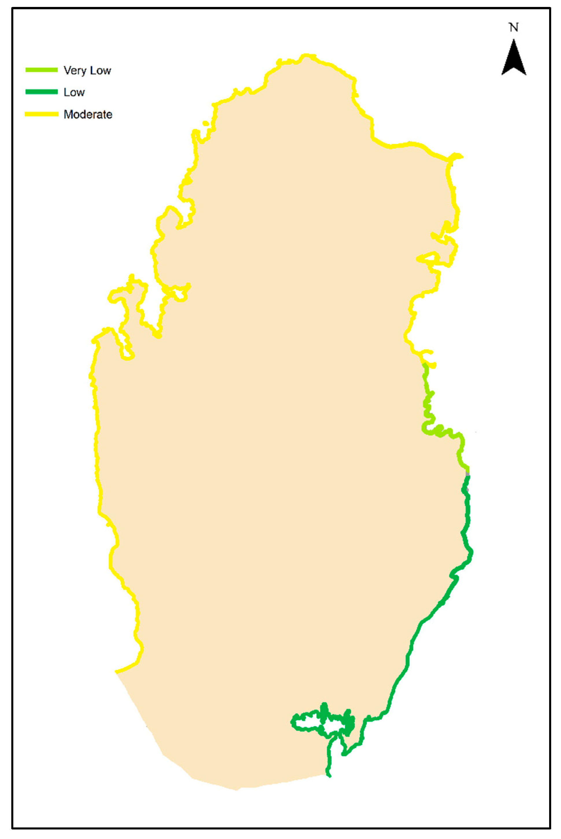
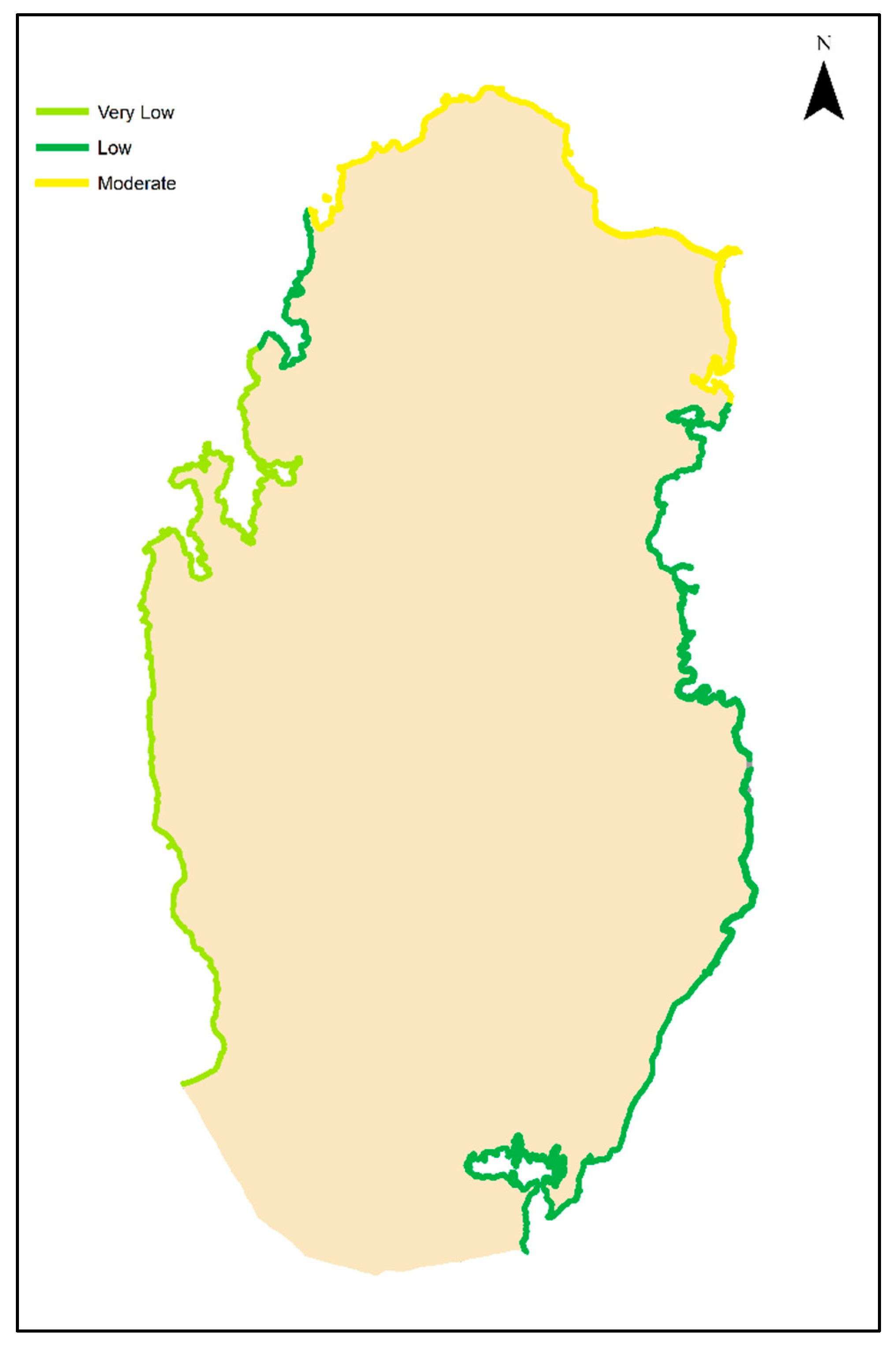
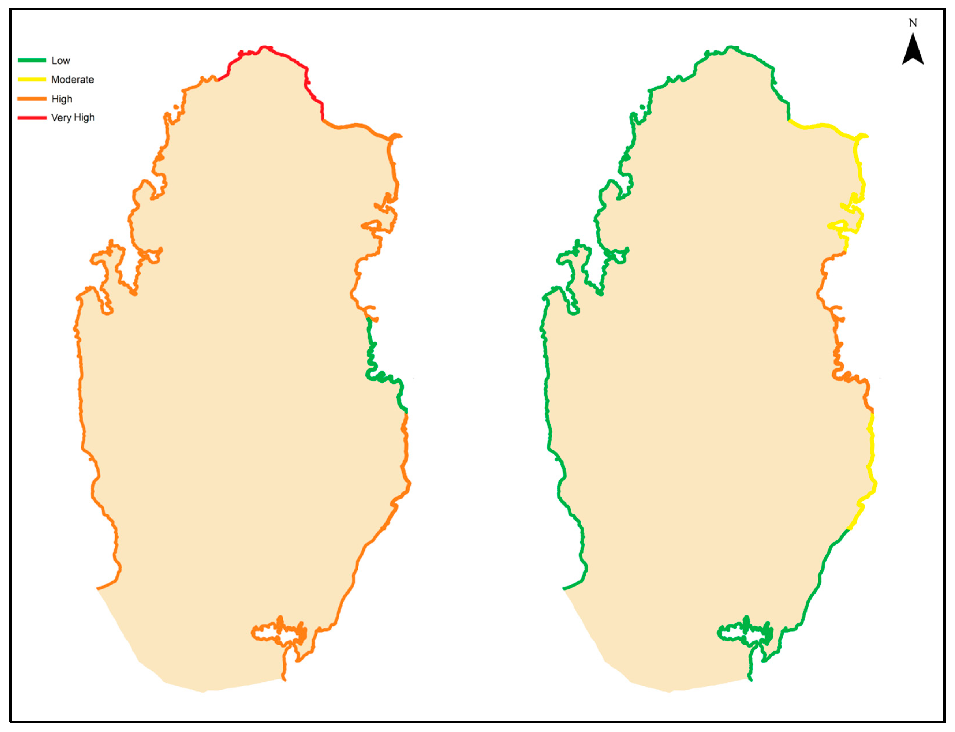

| Study | Parameters |
|---|---|
| [11] | Geomorphology, Coastal slope (%), Shoreline erosion/ accretion rates (m/ year), Emerged beach width (m), Dune, River discharge (m3/s), Relative sea-level change (mm/year), Mean significant wave height (m), Mean tide range (m). |
| [13] | Geomorphology, Coastal slope(%), Erosion/Accretion (m/yr), Relative SLR change (mm/yr), Mean tide (m), Mean significant wave height (m). |
| [24] | Elevation (m), Slope(degrees), Tidal range (m), Sea level rise (mm/yr), Geomorphology, Significant Wave Height, Shoreline change (m/yr), Land use/cover, Population (Numbers) Road Network, Cultural Heritage Sites |
| [30] | Absolute SLR (mm/yr), Elevation (m), Erosion/Accretion (m/yr), Geomorphology, Tidal range (m), Population density (people/km2). |
| [31] | Bathymerty (m), Geomorphology (landform), Lithology (rock type), Island (km2), Mangrove (km2), Vegetation (km2), Shoreline change rate (m/yr), Coastal length (km), Coastal slope (m), SLR (mm/yr), Agriculture (km2), Infra-strucutre (km2), Road (km), Population density (sq km) Gender composition. |
| [32] | Geomorphology, Shoreline change rate (m/yr), Coastal slope (%), Maximum significant wave height (m), Maximum tidal range (m), Grain size of landward soil, D50 (mm), Vegetation behind the back-beach, Coverage of Posidonia oceanica (%). |
| [33] | Geomorphology, Coastal slope (%), Land use/Land cover, Shoreline change (m/ year), Mean Spring tide (m), Significant wave height (m). |
| Importance | Definition | Explanation |
|---|---|---|
| 1 | Equal Importance | Two elements contribute equally to the objective. |
| 3 | Moderate Importance | Experience and judgment slightly favor one element over another. |
| 5 | Strong Importance | Experience and judgment strongly favor one element over another. |
| 7 | Very Strong Importance | One element is favored very strongly over another. |
| 9 | Extreme Importance | The evidence favoring one element over another is of the highest possible order of affirmation. |
| PVI Variables | Geomorphology | Coastal Slope | Sea Level Rise | Shoreline Erosion | Mean Tide Range | Mean Wave Height |
|---|---|---|---|---|---|---|
| Geomorphology | 1 | 3 | 1/3 | 5 | 7 | 3 |
| Coastal Slope | 1/3 | 1 | 1/5 | 2 | 3 | 1/2 |
| Sea Level Rise | 3 | 5 | 1 | 4 | 9 | 6 |
| Shoreline Erosion | 1/5 | 1/2 | 1/4 | 1 | 5 | 3 |
| Mean Tide Range | 1/7 | 1/3 | 1/9 | 1/5 | 1 | 1/4 |
| Mean Wave Height | 1/3 | 2 | 1/6 | 1/3 | 4 | 1 |
| SVI Variables | Population Density | Land Use | GDP Per Capita |
|---|---|---|---|
| Population Density | 1 | 1/2 | 3 |
| Land Use | 2 | 1 | 5 |
| GDP Per Capita | 1/3 | 1/5 | 1 |
| Variables | Weighted Criteria (%) |
|---|---|
| Geomorphology | 25.3 |
| Coastal Slope | 9.2 |
| Sea Level Rise | 43.2 |
| Shoreline Erosion/Accretion | 10.8 |
| Mean Tide Range | 2.8 |
| Mean Wave Height | 8.7 |
| Variables | Weighted Criteria (%) |
|---|---|
| Population Density | 30.9 |
| Land Use | 58.2 |
| GDP Per Capita | 10.9 |
| Variable | Low | Moderate | High | Very High | Total |
|---|---|---|---|---|---|
| PVI Range | 0.40–3.26 | 3.27–11.02 | 11.03–26.12 | 26.13–51.03 | NA |
| PVI Results according to Distance (km) | 35 | 0 | 447 | 78 | 560 |
Disclaimer/Publisher’s Note: The statements, opinions and data contained in all publications are solely those of the individual author(s) and contributor(s) and not of MDPI and/or the editor(s). MDPI and/or the editor(s) disclaim responsibility for any injury to people or property resulting from any ideas, methods, instructions or products referred to in the content. |
© 2025 by the authors. Licensee MDPI, Basel, Switzerland. This article is an open access article distributed under the terms and conditions of the Creative Commons Attribution (CC BY) license (https://creativecommons.org/licenses/by/4.0/).
Share and Cite
Ba-Khamis, A.N.A.A.; Bilal, H.; Al-Ansari, T. Assessing Coastal Vulnerability to Sea Level Rise in Qatar: An Index-Based Approach Using Analytic Hierarchy Process. Climate 2025, 13, 236. https://doi.org/10.3390/cli13110236
Ba-Khamis ANAA, Bilal H, Al-Ansari T. Assessing Coastal Vulnerability to Sea Level Rise in Qatar: An Index-Based Approach Using Analytic Hierarchy Process. Climate. 2025; 13(11):236. https://doi.org/10.3390/cli13110236
Chicago/Turabian StyleBa-Khamis, Ali Nasser A. A., Hazrat Bilal, and Tareq Al-Ansari. 2025. "Assessing Coastal Vulnerability to Sea Level Rise in Qatar: An Index-Based Approach Using Analytic Hierarchy Process" Climate 13, no. 11: 236. https://doi.org/10.3390/cli13110236
APA StyleBa-Khamis, A. N. A. A., Bilal, H., & Al-Ansari, T. (2025). Assessing Coastal Vulnerability to Sea Level Rise in Qatar: An Index-Based Approach Using Analytic Hierarchy Process. Climate, 13(11), 236. https://doi.org/10.3390/cli13110236


