Co-Registration of UAV and Handheld LiDAR Data for Fine Phenotyping of Rubber Plantations with Complex Canopies

Abstract
1. Introduction
- (1)
- A semantics-guided, automatic registration method is proposed for rubber tree point clouds. This pose-free approach is particularly effective for cross-view registration in weakly structured scenarios, and has been successfully evaluated with high accuracy.
- (2)
- The method introduces a Woody Salient Keypoint (WSK) extraction algorithm that rapidly identifies keypoints with high repeatability, viewpoint invariance, and favorable spatial distribution through semantic-guided Regions of Interest (ROI) segmentation and salient point detection. It can still extract representative point primitives in rubber plantations with weak structural features and high local repetitiveness.
- (3)
- A benchmark ULS-HLS dataset for rubber trees has been released. It covers 25 sample plots across 5 testing areas, comprising over 400 million points. The dataset includes data from both leaf-on and leaf-off seasons, facilitating research on structural parameter extraction and phenotyping of rubber trees.
2. Materials and Methods
2.1. UAV and Handheld LiDAR Platforms
2.2. Study Sites and Dataset
2.3. Tree Keypoint Matching for Cross-View Registration
2.3.1. Woody Salient Keypoint Detection
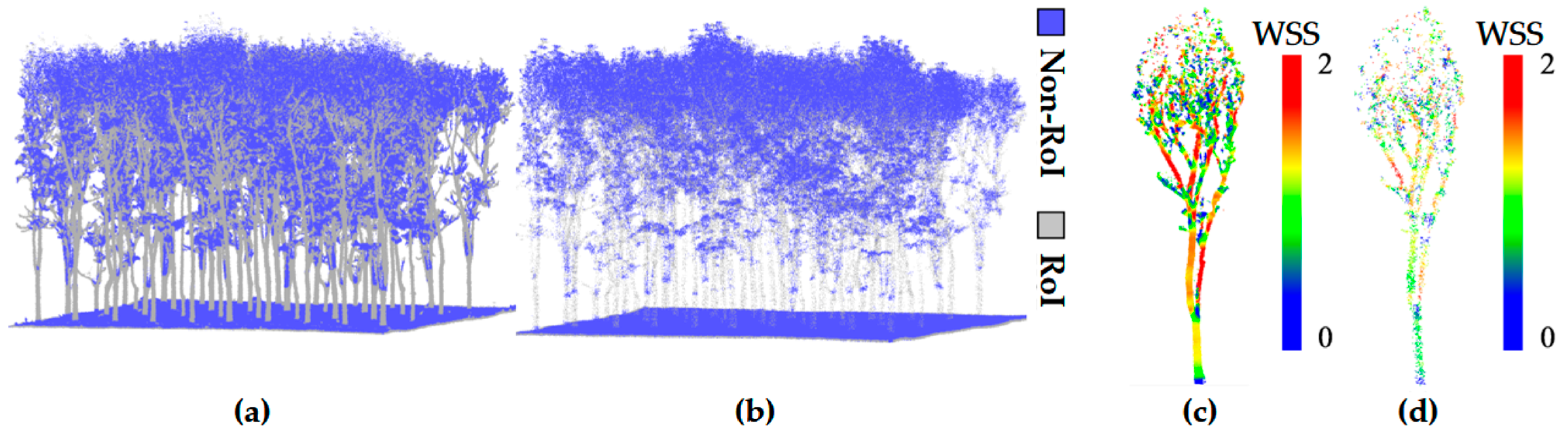
- ROI: Regions with strong structural stability and geometric significance (such as woody components), which exhibit consistency from different viewpoints and are suitable as the foundation for keypoint extraction and registration.
- Non-ROI: Regions with unstable geometric structures (such as leaf noise), which are easily affected by external disturbances, making it difficult to ensure the reliability of keypoints, and thus unsuitable as the basis for keypoint extraction.

| Algorithm 1 Woody Salient Keypoint Detection | |
| Input: Forest point cloud: PF | |
| Output: The WSK: KW | |
| 1. | Procedure: ROI Segmentation |
| 2. | Initialization: ROI set PI ← ϕ |
| 3. | For each point pi ∈ PF do |
| 4. | Compute SSS via Equation (3) |
| 5. | If SSS > δ then |
| 6. | PI ← PI ∪ {pi} |
| 7. | End if |
| 8. | End for |
| 9. | End Procedure |
| 10. | Procedure: Keypoints Detection |
| 11. | Initialization: feature set F ← ϕ, point set KI ← ϕ |
| 12. | For each point pi ∈ PI do |
| 13. | Compute WSS via Equation (4) |
| 14. | F ← F ∪ {(pi, WSS)} |
| 15. | End for |
| 16. | Sort F in ascending order by WSS. |
| 17. | KI ← The top Nr most significant points. |
| 18. | Initialize: keypoint set KW ← ϕ, suppression map set M ← {false} |
| 19. | For each point pi ∈KI do |
| 20. | If mi = false then |
| 21. | If WSSpi < WSSpi-neighbors then |
| 22. | KW ←KW ∪ {pi}, mpi-neighbors ← true |
| 23. | Else mpi ← true |
| 24. | End if |
| 25. | End if |
| 26. | End for |
| 27. | End Procedure |
| 28. | Return WSK set KW |
2.3.2. Correspondence and Transformation Estimation
2.3.3. Evaluation Criteria
3. Results
3.1. Parameter Setting and Sensitivity Analysis
3.2. Registration Performance
3.3. Efficacy Evaluation of the Keypoint Module
3.4. Comparison Experiments
4. Discussion
4.1. Impact of Seasonal Structural Differences
4.2. Performance on Other Tree Species
4.3. Limitations and Future Work
5. Conclusions
Author Contributions
Funding
Data Availability Statement
Acknowledgments
Conflicts of Interest
References
- Zeng, Z.; Miao, J.; Huang, X.; Chen, P.; Zhou, P.; Tan, J.; Wang, X. A Bottom-Up Multi-Feature Fusion Algorithm for Individual Tree Segmentation in Dense Rubber Tree Plantations Using Unmanned Aerial Vehicle–Light Detecting and Ranging. Plants 2025, 14, 1640. [Google Scholar] [CrossRef]
- Li, L.; Wang, X.; Zhou, G.; Zhang, H.; Xue, Y.; He, M.; Liu, G.; Wang, H.; Li, H. RTCrownNet: A Dual-Channel Deep Learning Framework for Accurate Rubber Tree Crown Extraction from UAV LiDAR Point Clouds. Comput. Electron. Agric. 2025, 239, 111093. [Google Scholar] [CrossRef]
- Hao, L.; Guoxiong, Z.; Xiangjun, W.; Huaiqing, Z. Fine Segmentation and Structural Parameter Extraction of Rubber Tree Point Cloud Based on LiDAR Using the TMGH Method. Comput. Electron. Agric. 2025, 239, 110950. [Google Scholar] [CrossRef]
- Yang, B.; Zhang, Y.; Li, W.; Huang, X.; Gao, X.; Qi, J.; Wang, X. Phenotypic and Transcriptomic Analysis Reveals Key Genes Associated with Plant Height in Rubber Tree and Functional Characterization of the Candidate Gene HbFLA11. Plant Genome 2025, 18, e70048. [Google Scholar] [CrossRef] [PubMed]
- Akhtar, M.S.; Zafar, Z.; Nawaz, R.; Fraz, M.M. Unlocking Plant Secrets: A Systematic Review of 3D Imaging in Plant Phenotyping Techniques. Comput. Electron. Agric. 2024, 222, 109033. [Google Scholar] [CrossRef]
- Liu, X.; Ma, Q.; Wu, X.; Hu, T.; Liu, Z.; Liu, L.; Guo, Q.; Su, Y. A Novel Entropy-Based Method to Quantify Forest Canopy Structural Complexity from Multiplatform Lidar Point Clouds. Remote Sens. Environ. 2022, 282, 113280. [Google Scholar] [CrossRef]
- Balestra, M.; Marselis, S.; Sankey, T.T.; Cabo, C.; Liang, X.; Mokroš, M.; Peng, X.; Singh, A.; Stereńczak, K.; Vega, C.; et al. LiDAR Data Fusion to Improve Forest Attribute Estimates: A Review. Curr. For. Rep. 2024, 10, 281–297. [Google Scholar] [CrossRef]
- Wang, X.; Chen, Q.; Wang, H.; Li, X.; Yang, H. Automatic Registration Framework for Multi-Platform Point Cloud Data in Natural Forests. Int. J. Remote Sens. 2023, 44, 4596–4616. [Google Scholar] [CrossRef]
- Qi, Y.; Coops, N.C.; Daniels, L.D.; Butson, C.R. Comparing Tree Attributes Derived from Quantitative Structure Models Based on Drone and Mobile Laser Scanning Point Clouds across Varying Canopy Cover Conditions. ISPRS J. Photogramm. Remote Sens. 2022, 192, 49–65. [Google Scholar] [CrossRef]
- Kükenbrink, D.; Marty, M.; Rehush, N.; Abegg, M.; Ginzler, C. Evaluating the Potential of Handheld Mobile Laser Scanning for an Operational Inclusion in a National Forest Inventory—A Swiss Case Study. Remote Sens. Environ. 2025, 321, 114685. [Google Scholar] [CrossRef]
- Qiu, J.; Han, Z.; Liu, L.; Zhang, J. FFMT: Unsupervised RGB-D Point Cloud Registration via Fusion Feature Matching with Transformer. Appl. Sci. 2025, 15, 2472. [Google Scholar] [CrossRef]
- Liu, J.; Guo, Y.; Yang, J.; Zhu, N.; Dai, W.; Yu, Q. Forest Point Cloud Registration: A Review. For. Res. 2024, 4, e018. [Google Scholar] [CrossRef]
- Dai, W.; Kan, H.; Tan, R.; Yang, B.; Guan, Q.; Zhu, N.; Xiao, W.; Dong, Z. Multisource Forest Point Cloud Registration with Semantic-Guided Keypoints and Robust RANSAC Mechanisms. Int. J. Appl. Earth Obs. Geoinf. 2022, 115, 103105. [Google Scholar] [CrossRef]
- Xuming, G.; ZhaoChen, H.; Qing, Z.; Han, H.; Bo, X.; Min, C. CPS: A Novel Canopy Profile Skyline Descriptor for UAV and Terrestrial-Based Forest Point Cloud Registration. Int. J. Appl. Earth Obs. Geoinf. 2024, 130, 103928. [Google Scholar] [CrossRef]
- Yu, S.; Tang, Z.; Zhang, B.; Dai, J.; Cai, S. Automatic Registration of Terrestrial and UAV LiDAR Forest Point Clouds Through Canopy Shape Analysis. Forests 2025, 16, 1347. [Google Scholar] [CrossRef]
- Ge, X. Automatic Markerless Registration of Point Clouds with Semantic-Keypoint-Based 4-Points Congruent Sets. ISPRS J. Photogramm. Remote Sens. 2017, 130, 344–357. [Google Scholar] [CrossRef]
- Dong, Z.; Yang, B.; Liu, Y.; Liang, F.; Li, B.; Zang, Y. A Novel Binary Shape Context for 3D Local Surface Description. ISPRS J. Photogramm. Remote Sens. 2017, 130, 431–452. [Google Scholar] [CrossRef]
- Chen, H.; Tan, J.; Wang, X.; Wang, X.; Wu, X.; Yang, R.; Hu, X. TPM: Efficient Tree Point Matching for ULS-TBLS Point Clouds in Weakly Structured Forests. IEEE J. Sel. Top. Appl. Earth Obs. Remote Sens. 2025, 18, 29433–29449. [Google Scholar] [CrossRef]
- Zhong, Y. Intrinsic Shape Signatures: A Shape Descriptor for 3D Object Recognition. In Proceedings of the 2009 IEEE 12th International Conference on Computer Vision Workshops, ICCV Workshops, Kyoto, Japan, 27 September–4 October 2009; pp. 689–696. [Google Scholar]
- Rister, B.; Horowitz, M.A.; Rubin, D.L. Volumetric Image Registration From Invariant Keypoints. IEEE Trans. Image Process. 2017, 26, 4900–4910. [Google Scholar] [CrossRef]
- Prawira, W.; Nasrullah, E.; Sulistiyanti, S.R.; Setyawan, F.X.A. The Detection of 3D Object Using a Method of a Harris Corner Detector and Lucas-Kanade Tracker Based on Stereo Image. In Proceedings of the 2017 International Conference on Electrical Engineering and Computer Science (ICECOS), Palembang, Indonesia, 22–23 August 2017; pp. 163–166. [Google Scholar]
- Zhang, S.; Wang, H.; Wang, C.; Wang, Y.; Wang, S.; Yang, Z. An Improved RANSAC-ICP Method for Registration of SLAM and UAV-LiDAR Point Cloud at Plot Scale. Forests 2024, 15, 893. [Google Scholar] [CrossRef]
- Tan, Y.; Xu, X.; You, H.; Zhang, Y.; Wang, D.; Onda, Y.; Gomi, T.; Wang, X.; Chen, M. Automated Registration of Forest Point Clouds from Terrestrial and Drone Platforms Using Structural Features. ISPRS J. Photogramm. Remote Sens. 2025, 223, 28–45. [Google Scholar] [CrossRef]
- Dai, X.; Qi, H.; Wang, X.; Xu, Y.; Jiang, Q.; Zhang, Q.; Wang, X.; Chen, J.; Liu, G.; Liang, X. A Novel Method for ULS-TLS Forest Point Cloud Registration Based on Height Context Descriptor. For. Ecosyst. 2025, 14, 100369. [Google Scholar] [CrossRef]
- Shao, J.; Yao, W.; Wan, P.; Luo, L.; Wang, P.; Yang, L.; Lyu, J.; Zhang, W. Efficient Co-Registration of UAV and Ground LiDAR Forest Point Clouds Based on Canopy Shapes. Int. J. Appl. Earth Obs. Geoinf. 2022, 114, 103067. [Google Scholar] [CrossRef]
- Jiang, L.; Liu, Y.; Dong, Z.; Li, Y.; Lin, Y. Lightweight Deep Learning Method for End-to-End Point Cloud Registration. Graph. Models 2025, 137, 101252. [Google Scholar] [CrossRef]
- Chen, L.; Feng, C.; Ma, Y.; Zhao, Y.; Wang, C. A Review of Rigid Point Cloud Registration Based on Deep Learning. Front. Neurorobot. 2023, 17, 22. [Google Scholar] [CrossRef]
- Lu, F.; Chen, G.; Liu, Y.; Zhang, L.; Qu, S.; Liu, S.; Gu, R. HRegNet: A Hierarchical Network for Large-Scale Outdoor LiDAR Point Cloud Registration. In Proceedings of the 2021 IEEE/CVF International Conference on Computer Vision (ICCV), Montreal, QC, Canada, 10–17 October 2021; pp. 15994–16003. [Google Scholar]
- Long, J.; Shelhamer, E.; Darrell, T. Fully Convolutional Networks for Semantic Segmentation. IEEE Trans. Pattern Anal. Mach. Intell. 2015, 39, 640–651. [Google Scholar]
- Charles, R.Q.; Su, H.; Kaichun, M.; Guibas, L.J. PointNet: Deep Learning on Point Sets for 3D Classification and Segmentation. In Proceedings of the 2017 IEEE Conference on Computer Vision and Pattern Recognition (CVPR), Honolulu, HI, USA, 21–26 July 2017; pp. 77–85. [Google Scholar]
- Vaswani, A.; Shazeer, N.; Parmar, N.; Uszkoreit, J.; Jones, L.; Gomez, A.N.; Kaiser, Ł.; Po-losukhin, I. Attention Is All You Need. In Proceedings of the Advances in Neural Information Processing Systems; Guyon, I., Luxburg, U.V., Bengio, S., Wallach, H., Fergus, R., Vishwanathan, S., Garnett, R., Eds.; Curran Associates, Inc.: Red Hook, NY, USA, 2017; Volume 30. [Google Scholar]
- Choy, C.; Park, J.; Koltun, V. Fully Convolutional Geometric Features. In Proceedings of the 2019 IEEE/CVF International Conference on Computer Vision (ICCV), Seoul, Republic of Korea, 27 October–2 November 2019; pp. 8957–8965. [Google Scholar]
- Ao, S.; Hu, Q.; Yang, B.; Guo, Y. SpinNet: Learning a General Surface Descriptor for 3D Point Cloud Registration. In Proceedings of the (CVPR 2021), Nashville, TN, USA, 20–25 June 2021. [Google Scholar]
- Liu, W.; Nie, S.; Xia, S.; Wang, C.; Wang, J.; Xi, X.; Cheng, F. Benchmarking ULS-TLS Point Cloud Registration Algorithms in Forest Environments. IEEE Trans. Geosci. Remote Sens. 2025, 63, 5703214. [Google Scholar] [CrossRef]
- Geiger, A.; Lenz, P.; Urtasun, R. Are We Ready for Autonomous Driving? The KITTI Vision Benchmark Suite. In Proceedings of the 2012 IEEE Conference on Computer Vision and Pattern Recognition, Providence, RI, USA, 16–21 June 2012; pp. 3354–3361. [Google Scholar]
- Zeng, A.; Song, S.; Nießner, M.; Fisher, M.; Xiao, J.; Funkhouser, T. 3DMatch: Learning Local Geometric Descriptors from RGB-D Reconstructions. In Proceedings of the 2017 IEEE Conference on Computer Vision and Pattern Recognition (CVPR), Honolulu, HI, USA, 21–26 July 2017; pp. 199–208. [Google Scholar]
- Pomerleau, F.; Liu, M.; Colas, F.; Siegwart, R. Challenging Data Sets for Point Cloud Registration Algorithms. Int. J. Robot. Res. 2012, 31, 1705–1711. [Google Scholar] [CrossRef]
- Dong, Z.; Liang, F.; Yang, B.; Xu, Y.; Stilla, U. Registration of Large-Scale Terrestrial Laser Scanner Point Clouds: A Review and Benchmark. ISPRS J. Photogramm. Remote Sens. 2020, 163, 327–342. [Google Scholar] [CrossRef]
- Puliti, S.; Pearse, G.; Surov, P.; Wallace, L.; Hollaus, M.; Wielgosz, M.; Astrup, R. FOR-Instance: A UAV Laser Scanning Benchmark Dataset for Semantic and Instance Segmentation of Individual Trees. arXiv 2023, arXiv:2309.01279. [Google Scholar] [CrossRef]
- Liang, X.; Qi, H.; Deng, X.; Chen, J.; Cai, S.; Zhang, Q.; Wang, Y.; Kukko, A.; Hyypp, J. ForestSemantic: A Dataset for Semantic Learning of Forest from Close-Range Sensing. Geo-Spat. Inf. Sci. 2025, 28, 185–211. [Google Scholar] [CrossRef]
- Xinlian, L.; Juha, H.; Harri, K.; Matti, L.; Jiri, P.; Norbert, P.; Markus, H.; Gábor, B.; Pirotti, F.; Jan, H. International Benchmarking of Terrestrial Laser Scanning Approaches for Forest Inventories. Isprs J. Photogramm. Remote Sens. 2018, 144, 137–179. [Google Scholar]
- Eysn, L.; Hollaus, M.; Lindberg, E.; Berger, F.; Monnet, J.-M.; Dalponte, M.; Kobal, M.; Pellegrini, M.; Lingua, E.; Mongus, D.; et al. A Benchmark of Lidar-Based Single Tree Detection Methods Using Heterogeneous Forest Data from the Alpine Space. Forests 2015, 6, 1721–1747. [Google Scholar] [CrossRef]
- Cao, Y.; Ball, J.G.C.; Coomes, D.A.; Steinmeier, L.; Knapp, N.; Wilkes, P.; Disney, M.; Calders, K.; Burt, A.; Lin, Y. Benchmarking Airborne Laser Scanning Tree Segmentation Algorithms in Broadleaf Forests Shows High Accuracy Only for Canopy Trees. Int. J. Appl. Earth Obs. Geoinf. 2023, 123, 103490. [Google Scholar] [CrossRef]
- Zhou, Q.-Y.; Park, J.; Koltun, V. Fast Global Registration. In Proceedings of the Computer Vision—ECCV 2016, Amsterdam, The Netherlands, 11–14 October 2016; Leibe, B., Matas, J., Sebe, N., Welling, M., Eds.; Springer International Publishing: Cham, Switzerland, 2016; pp. 766–782. [Google Scholar]
- Salti, S.; Tombari, F.; Stefano, L.D. SHOT: Unique Signatures of Histograms for Surface and Texture Description. Comput. Vis. Image Underst. 2014, 125, 251–264. [Google Scholar] [CrossRef]
- Rusu, R.B.; Blodow, N.; Beetz, M. Fast Point Feature Histograms (FPFH) for 3D Registration. In Proceedings of the 2009 IEEE International Conference on Robotics and Automation, Kyoto, Japan, 27 September–4 October 2009; pp. 3212–3217. [Google Scholar]
- Yue, Z.; Xiao, C. A Meta-Review of Remote Sensing for Rubber Plantations. Int. J. Appl. Earth Obs. Geoinf. 2025, 141, 104625. [Google Scholar] [CrossRef]
- Shi, Y.; Wang, T.; Skidmore, A.K.; Heurich, M. Important LiDAR Metrics for Discriminating Forest Tree Species in Central Europe. ISPRS J. Photogramm. Remote Sens. 2018, 137, 163–174. [Google Scholar] [CrossRef]
- Lin, Y.-C.; Liu, J.; Fei, S.; Habib, A. Leaf-Off and Leaf-On UAV LiDAR Surveys for Single-Tree Inventory in Forest Plantations. Drones 2021, 5, 115. [Google Scholar] [CrossRef]
- Zhu, X.; Liu, J.; Skidmore, A.K.; Premier, J.; Heurich, M. A Voxel Matching Method for Effective Leaf Area Index Estimation in Temperate Deciduous Forests from Leaf-on and Leaf-off Airborne LiDAR Data. Remote Sens. Environ. 2020, 240, 111696. [Google Scholar] [CrossRef]
- Rahman, M.Z.A.; Gorte, B.G.H. Tree Filtering for High Density Airborne LiDAR Data. In Proceedings of the SilviLaser 2008, 8th International Conference on LiDAR Applications in Forest Assessment and Inventory, Heriot-Watt University, Edinburgh, UK, 17–19 September, 2008. [Google Scholar]
- Imangholiloo, M.; Saarinen, N.; Holopainen, M.; Yu, X.; Hyyppä, J.; Vastaranta, M. Using Leaf-Off and Leaf-On Multispectral Airborne Laser Scanning Data to Characterize Seedling Stands. Remote Sens. 2020, 12, 3328. [Google Scholar] [CrossRef]
- Besl, P.J.; Mckay, H.D. A Method for Registration of 3-D Shapes. IEEE Trans. Pattern Anal. Mach. Intell. 1992, 14, 239–256. [Google Scholar] [CrossRef]
- Kane, V.R.; Bakker, J.D.; McGaughey, R.J.; Lutz, J.A.; Gersonde, R.F.; Franklin, J.F. Examining Conifer Canopy Structural Complexity across Forest Ages and Elevations with LiDAR Data. Can. J. For. Res. 2010, 40, 774–787. [Google Scholar] [CrossRef]
- Li, Y.; Xie, D.; Wang, Y.; Jin, S.; Zhou, K.; Zhang, Z.; Li, W.; Zhang, W.; Mu, X.; Yan, G. Individual Tree Segmentation of Airborne and UAV LiDAR Point Clouds Based on the Watershed and Optimized Connection Center Evolution Clustering. Ecol. Evol. 2023, 13, e10297. [Google Scholar] [CrossRef] [PubMed]
- Seidel, D.; Annighöfer, P.; Ehbrecht, M.; Magdon, P.; Wöllauer, S.; Ammer, C. Deriving Stand Structural Complexity from Airborne Laser Scanning Data—What Does It Tell Us about a Forest? Remote Sens. 2020, 12, 1854. [Google Scholar] [CrossRef]
- Sharma, G.; Morgenroth, J.; Richards, D.R.; Ye, N. Classifying Canopy Complexity to Assess the Reliability of Airborne LiDAR in Urban Forest Assessments. Urban For. Urban Green. 2025, 113, 129102. [Google Scholar] [CrossRef]


| Platform | ULS | HLS |
|---|---|---|
| Instrument | CBI-Lite | LiGrip H120 |
| Accuracy | 5 cm@70 m | ≤5 cm |
| Measurement rate | 640,000 pts/s | 320,000 pts/s |
| Wavelength | 905 nm | 905 nm |
| Range accuracy | 120 m | 120 m |
| Weight | 1.28 kg | 1.83 kg |
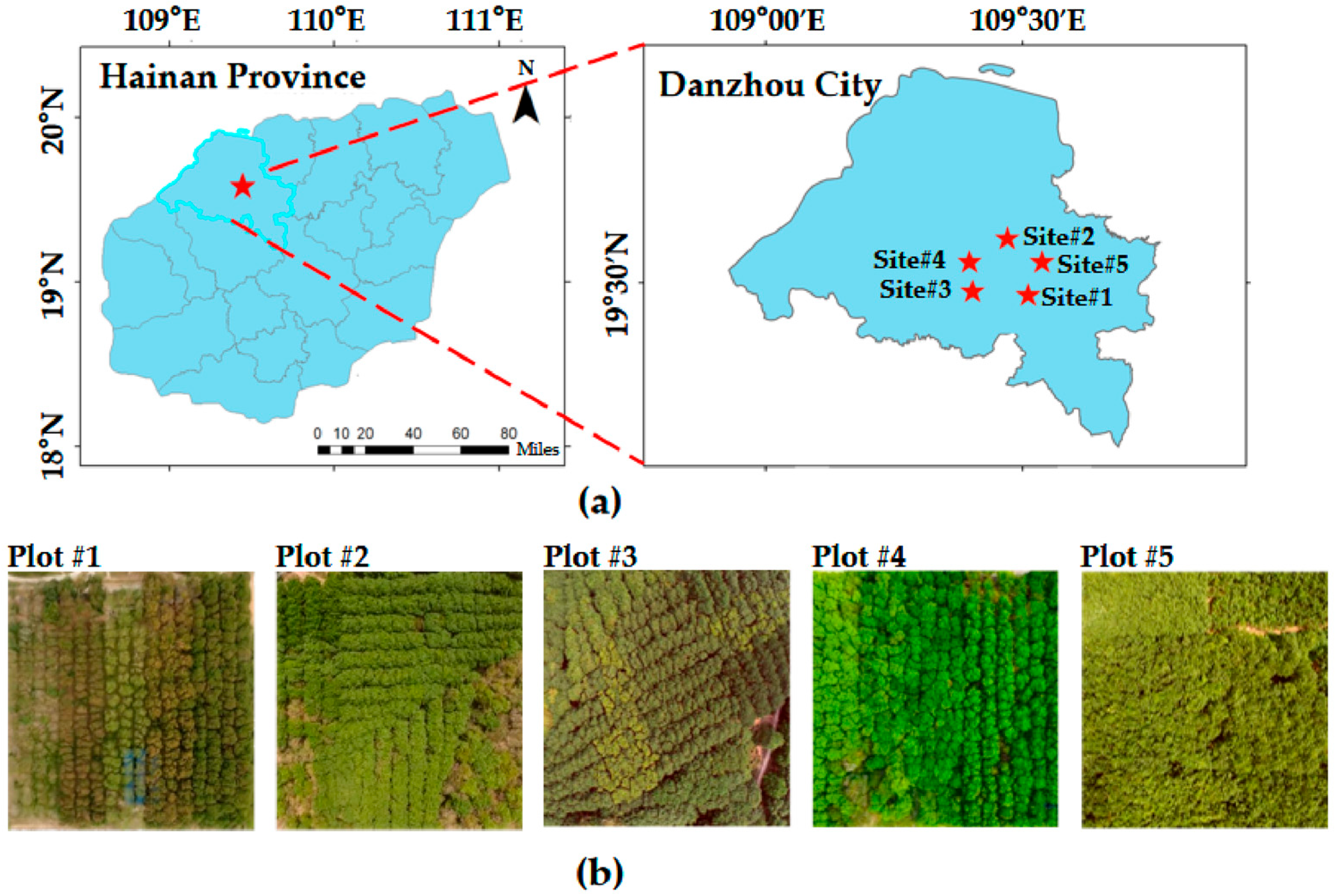
| Sites | Growth Stage | Plot Dimension (m2) | Tree Density (1/ha) | Avg. Height (m) | Canopy Density (%) | Collection Date | Canopy Complexity | Difficulty Level |
|---|---|---|---|---|---|---|---|---|
| Site #1 | Mature | 30 × 30 | 433 | 22 | 67 | March | Simple | Low |
| Site #2 | Mature | 30 × 30 | 610 | 24 | 60 | March | Simple | Low |
| Site #3 | Mature | 30 × 30 | 555 | 22 | 64 | March | Simple | Low |
| Site #4 | Mature | 30 × 30 | 561 | 22 | 94 | August | Complex | High |
| Site #5 | Juvenile | 30 × 30 | 1755 | 15 | 68 | March | Simple | Low |
| Survey Site | Angle Error (Degree) | Centroid Error (m) | RMSE (m) | Time (min) | ||
|---|---|---|---|---|---|---|
| θX | θY | θZ | ||||
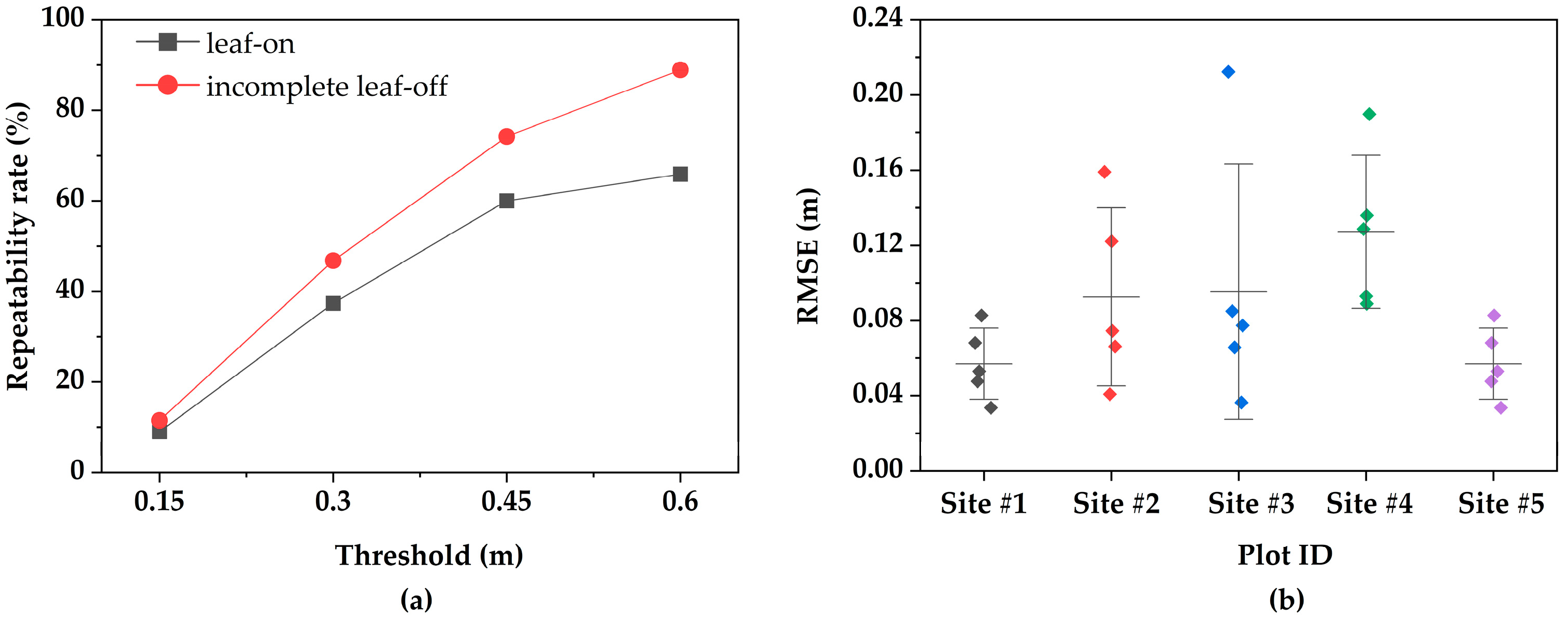
| Site #1 | 0.12 | 0.09 | 0.13 | 0.04 | 0.06 | 3.4 |
| Site #2 | 0.08 | 0.16 | 0.15 | 0.09 | 0.10 | 4.35 |
| Site #3 | 0.12 | 0.10 | 0.11 | 0.08 | 0.10 | 2.93 |
| Site #4 | 0.34 | 0.45 | 0.47 | 0.13 | 0.14 | 3.48 |
| Site #5 | 0.16 | 0.14 | 0.15 | 0.06 | 0.08 | 3.30 |
| Average | 0.16 | 0.19 | 0.20 | 0.08 | 0.09 | 3.49 |
| Method | Keypoint Number | ANND (m) | Extraction Time (s) | RMSE (m) | |
|---|---|---|---|---|---|
| ULS | HLS | ||||
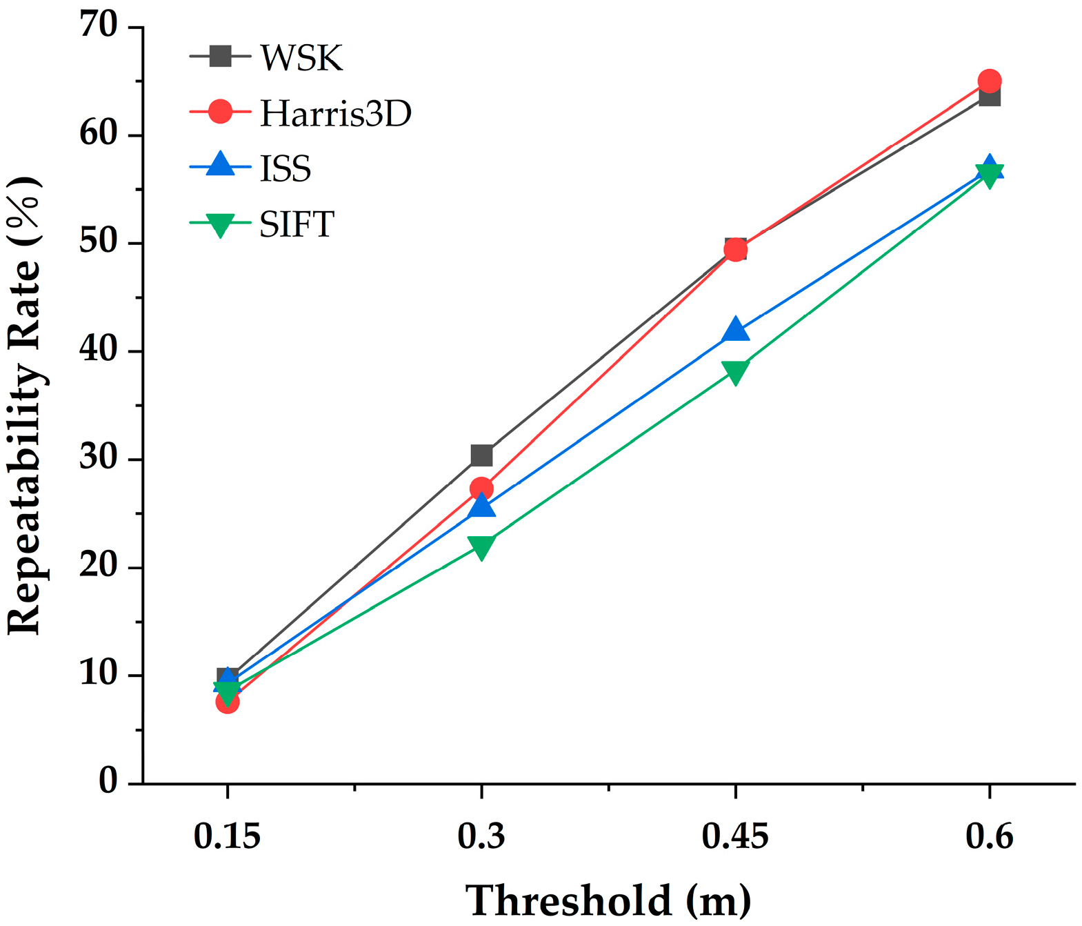
| WSK (ours) | 18,027 | 19,242 | 0.37 | 7 | 0.06 |
| Harris3D | 18,526 | 19,116 | 0.38 | 3.6 | 0.13 |
| ISS | 17,076 | 18,697 | 0.34 | 3 | 0.07 |
| SIFT | 15,912 | 16,487 | 0.39 | 34.5 | 0.11 |
| Survey Site | Method | Angle Error (Degree) | Centroid Error (m) | RMSE (m) | ||
|---|---|---|---|---|---|---|
| θX | θY | θZ | ||||
| Site #1 | SAC-IA | 3.02 | 2.70 | 2.02 | 0.25 | 0.40 |
| HRegNet | 0.37 | 0.56 | 0.61 | 0.31 | 0.37 | |
| Ours | 0.12 | 0.09 | 0.13 | 0.04 | 0.06 | |
| Site #2 | SAC-IA | 0.86 | 0.94 | 1.00 | 0.24 | 0.34 |
| HRegNet | 0.29 | 0.31 | 0.46 | 0.27 | 0.31 | |
| Ours | 0.08 | 0.16 | 0.15 | 0.09 | 0.10 | |
| Site #3 | SAC-IA | 10.81 | 11.71 | 4.02 | 7.59 | 11.27 |
| HRegNet | 0.49 | 0.70 | 0.64 | 0.30 | 0.39 | |
| Ours | 0.12 | 0.10 | 0.11 | 0.08 | 0.10 | |
| Site #4 | SAC-IA | 3.78 | 3.98 | 1.70 | 0.97 | 1.61 |
| HRegNet | 1.83 | 1.49 | 1.9 | 1.58 | 1.73 | |
| Ours | 0.34 | 0.45 | 0.47 | 0.13 | 0.14 | |
| Site #5 | SAC-IA | 9.72 | 10.25 | 3.06 | 6.19 | 5.58 |
| HRegNet | 0.46 | 0.57 | 0.63 | 0.35 | 0.42 | |
| Ours | 0.16 | 0.14 | 0.15 | 0.06 | 0.08 | |
| Site ID | Tree Species | Angle Error (Degree) | Centroid Error (m) | RMSE (m) | ||
|---|---|---|---|---|---|---|
| θX | θY | θZ | ||||
| S01 | mixed | 1.54 | 1.66 | 1.31 | 0.67 | 0.91 |
| S02 | willow | 0.28 | 1.36 | 1.36 | 0.18 | 0.32 |
| S03 | poplar | 0.50 | 0.84 | 0.87 | 0.12 | 0.17 |
| S04 | white birch | 0.17 | 0.21 | 0.13 | 0.07 | 0.11 |
| S05 | mixed | 0.32 | 0.22 | 0.30 | 0.05 | 0.12 |
| S06 | larch | 0.11 | 0.36 | 0.38 | 0.10 | 0.19 |
| S07 | poplar | 0.30 | 0.45 | 0.54 | 0.15 | 0.21 |
| S08 | Pinus sylvestris | 0.34 | 0.34 | 0.44 | 0.11 | 0.28 |
| S09 | mixed | 0.35 | 1.09 | 1.08 | 0.20 | 0.68 |
| S10 | eucalyptus | 0.13 | 0.19 | 0.20 | 0.12 | 0.15 |
| S11 | fir | 0.18 | 0.21 | 0.14 | 0.10 | 0.16 |
| S12 | fir | 0.17 | 0.21 | 0.21 | 0.08 | 0.11 |
| S13 | fir | 0.24 | 0.48 | 0.47 | 0.17 | 0.21 |
| S14 | Pinus yunnanensis | 0.04 | 0.14 | 0.15 | 0.04 | 0.06 |
| S15 | eucalyptus | 0.05 | 0.06 | 0.04 | 0.02 | 0.04 |
| S16 | eucalyptus | 0.10 | 0.26 | 0.28 | 0.04 | 0.08 |
| S17 | Pinus densata | 0.06 | 0.07 | 0.09 | 0.04 | 0.04 |
Disclaimer/Publisher’s Note: The statements, opinions and data contained in all publications are solely those of the individual author(s) and contributor(s) and not of MDPI and/or the editor(s). MDPI and/or the editor(s) disclaim responsibility for any injury to people or property resulting from any ideas, methods, instructions or products referred to in the content. |
© 2026 by the authors. Licensee MDPI, Basel, Switzerland. This article is an open access article distributed under the terms and conditions of the Creative Commons Attribution (CC BY) license.
Share and Cite
Tan, J.; Chen, H.; Zhang, K.; Yang, H.; Wang, X.; Yang, R.; Hu, G.; Li, S.; Liu, J.; Wang, X. Co-Registration of UAV and Handheld LiDAR Data for Fine Phenotyping of Rubber Plantations with Complex Canopies. Plants 2026, 15, 376. https://doi.org/10.3390/plants15030376
Tan J, Chen H, Zhang K, Yang H, Wang X, Yang R, Hu G, Li S, Liu J, Wang X. Co-Registration of UAV and Handheld LiDAR Data for Fine Phenotyping of Rubber Plantations with Complex Canopies. Plants. 2026; 15(3):376. https://doi.org/10.3390/plants15030376
Chicago/Turabian StyleTan, Junxiang, Hao Chen, Kaihui Zhang, Hao Yang, Xiongjie Wang, Ronghao Yang, Guyue Hu, Shaoda Li, Jianfei Liu, and Xiangjun Wang. 2026. "Co-Registration of UAV and Handheld LiDAR Data for Fine Phenotyping of Rubber Plantations with Complex Canopies" Plants 15, no. 3: 376. https://doi.org/10.3390/plants15030376
APA StyleTan, J., Chen, H., Zhang, K., Yang, H., Wang, X., Yang, R., Hu, G., Li, S., Liu, J., & Wang, X. (2026). Co-Registration of UAV and Handheld LiDAR Data for Fine Phenotyping of Rubber Plantations with Complex Canopies. Plants, 15(3), 376. https://doi.org/10.3390/plants15030376