


AI-Powered Plant Science: Transforming Forestry Monitoring, Disease Prediction, and Climate Adaptation

Abstract
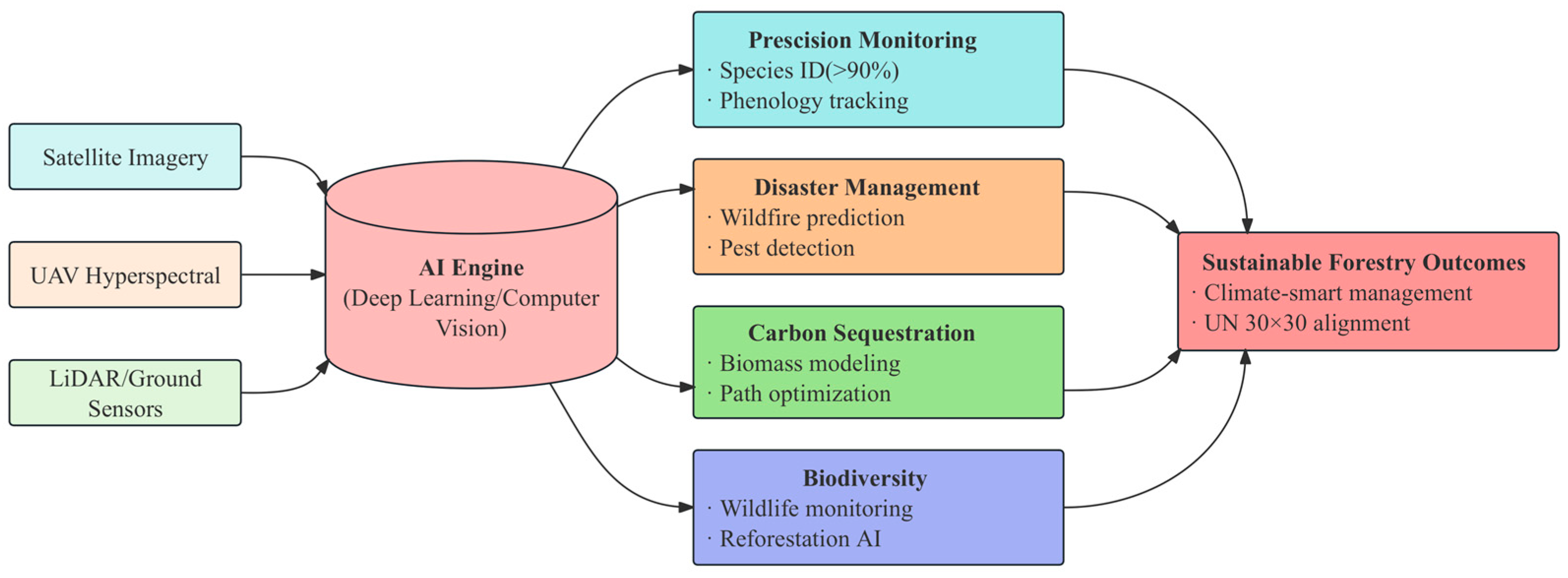
1. Introduction
2. Materials and Methods
2.1. Objective
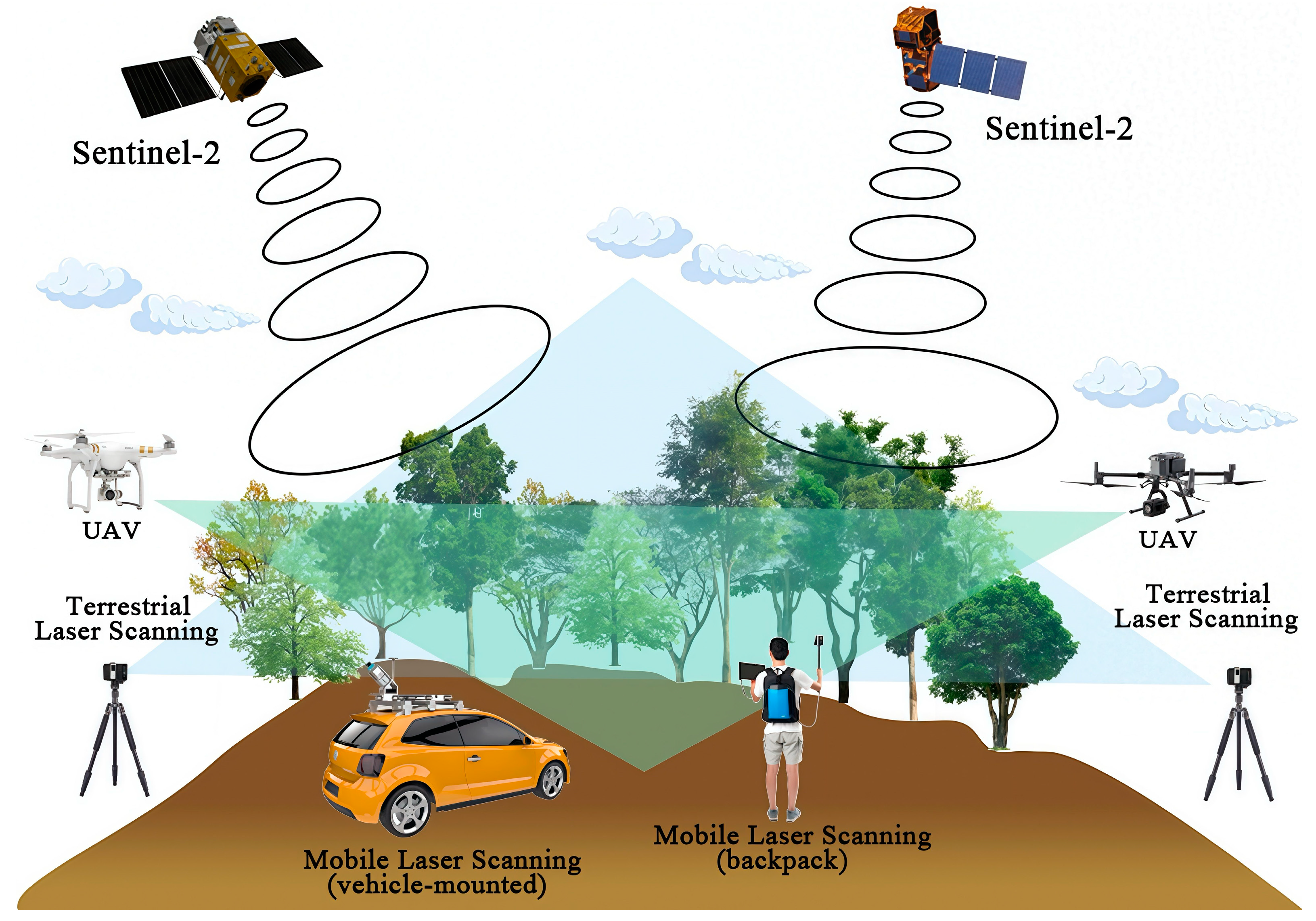
2.2. Data Collection
2.3. Data Synthesis and Analysis
3. Intelligent Monitoring and Assessment of Forest Resources
3.1. Integrated Monitoring of Forest Canopy Dynamics
3.2. Synergistic 3D Forest Monitoring with TLS and MLS
3.2.1. Full-Dimensional Trunk Parameterisation Mapping
3.2.2. Non-Destructive Analysis of Single Wood Attributes
3.2.3. Fine-Grained Assessment of Subcanopy Vegetation Layers
3.2.4. AI-Driven 3D Point Cloud Analysis for Forest Informatics
3.3. AI-Driven Tree Species Identification and Classification
3.3.1. General Species Identification Frameworks
3.3.2. Advances in Medicinal Plant Recognition
- (1)
- Incremental learning for medicinal plants:
- (2)
- Zero-shot machine learning recognition of unknown species:
- (3)
- Deep learning technology is used for the identification of medicinal plants:
3.4. AI-Driven Monitoring of Forest Phenological Dynamics
4. Disaster Early Warning and Emergency Management
4.1. Major Threats to Forest Ecosystems: Fires and Pests
4.1.1. AI-Driven Wildfire Detection, Prediction, and Spread Forecasting
4.1.2. AI-Enhanced Pest and Disease Detection in Forestry
4.2. AI-Powered Postdisaster Assessment for Ecological Recovery
5. Forest Carbon Sinks and Sustainable Management Innovations
5.1. The Critical Role of Forest Carbon Sequestration Systems
5.2. Intelligent Forestry Management Applications
5.2.1. AI-Driven Rational Planning of Logging Paths
5.2.2. AI-Driven Advancements in Illegal Logging Monitoring
5.2.3. AI-Driven Advancements in Forestry Breeding
6. Biodiversity Conservation and Ecological Restoration
6.1. AI-Powered Wildlife Monitoring: Overcoming Traditional Limitations
6.2. AI-Driven Habitat Integrity Assessment: Smarter Ecosystem Monitoring
6.3. AI-Powered Forest Restoration: A Technologically Green Revolution
7. Challenges and Future Prospects of AI in Forestry
7.1. The Challenges of Artificial Intelligence in Forestry
7.2. Robustness Assessment and Critical Comparison Analysis of Artificial Intelligence Models
7.3. The Future Research Directions of Artificial Intelligence in Forestry
8. Conclusions
Author Contributions
Funding
Acknowledgments
Conflicts of Interest
Appendix A

| Critical Evaluation of Model Robustness | |||
|---|---|---|---|
| AI Applications | Generalisability | Overfitting Risks | Edge-Case Scenarios |
| Remote Sensing | Cross-Validation: Implement k-fold cross-validation to ensure the model performs well on different subsets of the remote sensing data. Independent Test Set: Use a separate, geographically diverse test set to evaluate the model’s performance on unseen data. Data Diversity: Include data from various sensors, resolutions, and environmental conditions to enhance the model’s ability to generalise. | Regularisation: Apply L1 or L2 regularisation to prevent the model from learning noise in the training data. Early Stopping: Monitor the validation loss and stop training when it starts to increase, indicating overfitting. Model Complexity: Choose simpler models or use techniques like dropout in neural networks to reduce overfitting. | Data Augmentation: Simulate extreme weather conditions, sensor malfunctions, or unusual land cover changes to test the model’s robustness. Anomaly Detection: Implement anomaly detection algorithms to identify and handle outliers in the data. Case Studies: Analyse specific edge cases, such as rare natural disasters or unusual land use changes, to understand the model’s limitations. |
| Phenology Tracking | Cross-Validation: Use temporal cross-validation to ensure the model can generalise across different years and seasons. Independent Test Set: Evaluate the model on data from different geographic regions and climatic zones. Data Diversity: Incorporate data from various plant species, ecosystems, and climatic conditions to improve generalisation. | Regularisation: Apply regularisation techniques to prevent the model from fitting too closely to the training data. Early Stopping: Monitor the model’s performance on a validation set and stop training when performance degrades. Model Complexity: Opt for simpler models or use techniques like dropout to reduce the risk of overfitting. | Data Augmentation: Simulate extreme climatic events, such as droughts or heavy rainfall, to test the model’s robustness. Anomaly Detection: Implement anomaly detection to identify and handle unusual phenological events. Case Studies: Examine specific edge cases, such as sudden changes in phenological cycles due to climate change, to understand the model’s behaviour. |
| Wildfire Prediction | Cross-Validation: Use spatial and temporal cross-validation to ensure the model generalises across different regions and time periods. Independent Test Set: Evaluate the model on data from different fire seasons and regions. Data Diversity: Include data from various ecosystems, fire types, and environmental conditions to enhance generalisation. | Regularisation: Apply regularisation techniques to prevent the model from learning noise in the training data. Early Stopping: Monitor the validation loss and stop training when it starts to increase, indicating overfitting. Model Complexity: Choose simpler models or use techniques like dropout to reduce overfitting. | Edge-Case Scenarios: Data Augmentation: Simulate extreme fire conditions, such as high wind speeds or unusual fuel loads, to test the model’s robustness. Anomaly Detection: Implement anomaly detection to identify and handle unusual fire behaviour. Case Studies: Analyse specific edge cases, such as rare fire events or unusual fire spread patterns, to understand the model’s limitations. |
| Model Type | Application Field | Accuracy Rate/Performance | Dataset Size/Source | Limitation/Prejudice | Deployment Feasibility |
|---|---|---|---|---|---|
| XGBoost | Forest canopy health testing | Macro F1 scores in five biogeographic categories: 0.492–0.769 | UAV multispectral data | Sensitive to drought period samples with a 40% decrease in predictive power; inter-annual variability in climate affects accuracy (18.3% decrease) | High (suitable for multispectral data processing, but requires climate data calibration) |
| PointNet/PointNet++ | Single wood splitting and canopy gap detection | 89% accuracy for single wood segmentation; canopy gap detection (>1 m2) | TLS/MLS point cloud data (centimetre resolution) | Difficulty in reconstructing fine-grained branching topology | Medium (relies on high-density point cloud data with high computational resource requirements) |
| DGCNN | 3D tree structure reconstruction | Branch diameter RMSE: 3.02 cm; canopy asymmetry quantified | Dynamic scanning of point cloud data | Sensitive to point cloud density, reduced efficiency in complex terrain | Medium-high (requires real-time point cloud processing hardware support) |
| CapsNet-AGSO | Wildfire detection | Recall 95.65% (0.1 ha fire point); False Alarm Rate 3.2%; Smoke Detection Precision 98.98 | Multi-source data (meteorology, topography, vegetation distribution) | Sensitive to small fires, but relies on clear smoke patterns | High (for satellite/UAV real-time monitoring systems) |
| MA-Net | Fire propagation prediction | Predicts fire spread 5 days in advance; fire front speed/trajectory analysis | ERA5 climate reanalysis data + fuel load maps | Dependence on high-quality climate inputs and increased uncertainty under extreme weather conditions | Medium (needs to be integrated with GIS system, high requirement for real-time data updating) |
| YOLOv7-KCC | Tree species identification (shelterbelts) | The critical value is 0.5: 98.91% (3.69% improvement over YOLOv7). | UAV RGB image (manual labelling) | Sensitive to complex backgrounds, requires high-resolution images | High (embedded device deployment for rapid identification in the field) |
| ResNet-152 | Bark texture classification | Species recognition accuracy of 97.4% (8.2% improvement over static TLS) | MLS dynamic scanning texture data (0.5 mm/pixel) | Need to scan data from multiple angles, sensitive to lighting conditions | Medium (requires mobile scanning device support, high computational load) |
| Transformer | Monitoring of illegal logging | F1 score 0.92 (identification of new logging in the Amazon rainforest) | Sentinel-1/2 satellite imagery (both fused) | Reduced monitoring performance in rainy weather, reliance on less cloudy imagery | High (for automated analysis of large-scale satellite data) |
| GBLUP | Forest genome selection | 17.3% improvement in tree height prediction accuracy (conifers, samples >1532) | Genome-wide markers + phenotypic data (≥2811 samples required for tropical broadleaf trees) | High genomic complexity of tropical species requires large sample training | Low (reliance on laboratory gene sequencing, long field validation cycles) |
| Temporal-SE-ResNet50 | Wildlife monitoring | Recognition accuracy 93.10% (Camdeboo dataset) | Camera traps + thermal imaging (FLIR Boson 640) | Relying on knowledge of animal activity rhythms for optimal nighttime detection performance | Medium-high (requires deployment of smart camera network with real-time data transmission) |
References
- Chen, H.; Zeng, Z.; Wu, J.; Peng, L.; Lakshmi, V.; Yang, H.; Liu, J. Large Uncertainty on Forest Area Change in the Early 21st Century among Widely Used Global Land Cover Datasets. Remote Sens. 2020, 12, 3502. [Google Scholar] [CrossRef]
- Repo, A.; Albrich, K.; Jantunen, A.; Aalto, J.; Lehtonen, I.; Honkaniemi, J. Contrasting Forest Management Strategies: Impacts on Biodiversity and Ecosystem Services under Changing Climate and Disturbance Regimes. J. Environ. Manag. 2024, 371, 123124. [Google Scholar] [CrossRef] [PubMed]
- Windisch, M.G.; Humpenoder, F.; Merfort, L.; Bauer, N.; Luderer, G.; Dietrich, J.P.; Heinke, J.; Muller, C.; Abrahao, G.; Lotze-Campen, H.; et al. Hedging our Bet on Forest Permanence for the Economic Viability of Climate Targets. Nat. Commun. 2025, 16, 2460. [Google Scholar] [CrossRef] [PubMed]
- Wang, G.G.; Lu, D.; Gao, T.; Zhang, J.; Sun, Y.; Teng, D.; Yu, F.; Zhu, J. Climate-smart Forestry: An AI-enabled Sustainable Forest Management Solution for Climate Change Adaptation and Mitigation. J. For. Res. 2024, 36, 7. [Google Scholar] [CrossRef]
- Sarkissian, A.J.; Kutia, M. Editorial: Sustainable Forest Management under Climate Change Conditions—A Focus on Biodiversity Conservation and Forest Restoration. Front. For. Glob. Change 2024, 7, 1533425. [Google Scholar] [CrossRef]
- Li, Y.; Zhang, T.; Ding, Y.; Wadhwani, R.; Huang, X. Review and Perspectives of Digital Twin Systems for Wildland Fire Management. J. For. Res. 2024, 36, 14. [Google Scholar] [CrossRef]
- Freire, J.G.; DaCamara, C.C. Using Cellular Automata to Simulate Wildfire Propagation and to Assist in Fire Management. Nat. Hazards Earth Syst. Sci. 2019, 19, 169–179. [Google Scholar] [CrossRef]
- Zhang, Y.; Meng, W.; Yuan, X.; Yang, F.; Wang, H. Mapping Carbon Sinks in Megacity Ecosystem: Accuracy Estimation Coupling Experiment and Satellite Data based on GEE. Int. J. Environ. Sci. Technol. 2024, 1–20. [Google Scholar] [CrossRef]
- Gupta, D.K.; Pagani, A.; Zamboni, P.; Singh, A.K. AI-powered Revolution in Plant Sciences: Advancements, Applications, and Challenges for Sustainable Agriculture and Food Security. Explor. Foods Foodomics 2024, 2, 443–459. [Google Scholar] [CrossRef]
- Schoenegger, P.; Greenberg, S.; Grishin, A.; Lewis, J.; Caviola, L. AI can Outperform Humans in Predicting Correlations Between Personality Items. Commun. Psychol. 2025, 3, 23. [Google Scholar] [CrossRef]
- Chen, Y.M.; Hsiao, T.H.; Lin, C.H.; Fann, Y.C. Unlocking Precision Medicine: Clinical Applications of Integrating Health Records, Genetics, and Immunology through Artificial Intelligence. J. Biomed. Sci. 2025, 32, 16. [Google Scholar] [CrossRef]
- Pang, Y.; Shang, H.; Ren, X.; Liu, M.; Wang, M.; Li, G.; Chen, G.; Wang, Y.; Wang, H. Temporal and Spatial Characteristics of Forest Pests in China and their Association with Large-scale Circulation Indices. Environ. Entomol. 2024, 53, 1051–1061. [Google Scholar] [CrossRef] [PubMed]
- Nizami, A.S.; Liu, C.; Li, X.; Xue, Y.; Lu, W.; Zhang, C.; Daud, Z.B. Development and Applications of An Integrated Space-air-ground Observation Network in Natural Resource Monitoring and Supervision. E3S Web Conf. 2024, 520, 04018. [Google Scholar] [CrossRef]
- Wei, X.; Zhang, J.; Conrad, A.O.; Flower, C.E.; Pinchot, C.C.; Hayes-Plazolles, N.; Chen, Z.; Song, Z.; Fei, S.; Jin, J. Machine Learning-based Spectral and Spatial Analysis of Hyper- and multi-spectral Leaf Images for Dutch Elm Disease Detection and Resistance Screening. Artif. Intell. Agric. 2023, 10, 26–34. [Google Scholar] [CrossRef]
- Di Giuseppe, F.; McNorton, J.; Lombardi, A.; Wetterhall, F. Global Data-driven Prediction of Fire Activity. Nat. Commun. 2025, 16, 2918. [Google Scholar] [CrossRef] [PubMed]
- Ma, S.; Qu, Z.; Li, X.; Tang, Y. The Innovative Application and Prospects of AI and Gene Editing Technology in High-yield Crop Cultivation. Geogr. Res. Bull. 2024, 3, 219–222. [Google Scholar] [CrossRef]
- Holzinger, A.; Schweier, J.; Gollob, C.; Nothdurft, A.; Hasenauer, H.; Kirisits, T.; Haggstrom, C.; Visser, R.; Cavalli, R.; Spinelli, R.; et al. From Industry 5.0 to Forestry 5.0: Bridging the Gap with Human-Centered Artificial Intelligence. Curr. For. Rep. 2024, 10, 442–455. [Google Scholar] [CrossRef]
- Liu, Y.; Zhao, Q.; Wang, X.; Sheng, Y.; Tian, W.; Ren, Y. A Tree Species Classification Model Based on Improved YOLOv7 for Shelterbelts. Front. Plant Sci. 2024, 14, 1265025. [Google Scholar] [CrossRef] [PubMed]
- Ghamisi, P.; Rasti, B.; Yokoya, N.; Wang, Q.; Hoefle, B.; Bruzzone, L.; Bovolo, F.; Chi, M.; Anders, K.; Gloaguen, R.; et al. Multisource and Multitemporal Data Fusion in Remote Sensing: A Comprehensive Review of the State of the Art. IEEE Geosci. Remote Sens. Mag. 2019, 7, 6–39. [Google Scholar] [CrossRef]
- Zhou, J.; Zan, M.; Zhai, L.; Yang, S.; Xue, C.; Li, R.; Wang, X. Remote Sensing Estimation of Aboveground Biomass of Different Forest Types in Xinjiang Based on Machine Learning. Sci. Rep. 2025, 15, 6187. [Google Scholar] [CrossRef]
- Xian, G.; Liu, J.; Lin, Y.; Li, S.; Bian, C. Multi-Feature Fusion for Estimating Above-Ground Biomass of Potato by UAV Remote Sensing. Plants 2024, 13, 3356. [Google Scholar] [CrossRef] [PubMed]
- Guan, T.; Shen, Y.; Wang, Y.; Zhang, P.; Wang, R.; Yan, F. Advancing Forest Plot Surveys: A Comparative Study of Visual vs. LiDAR SLAM Technologies. Forests 2024, 15, 2083. [Google Scholar] [CrossRef]
- Toosi, A.; Samadzadegan, F.; Javan, F.D. Toward the Optimal Spatial Resolution Ratio for Fusion of UAV and Sentinel-2 Satellite Imageries Using Metaheuristic Optimization. Adv. Space Res. 2025, 75, 5254–5282. [Google Scholar] [CrossRef]
- Liu, J.; Huang, J.; Wu, M.; Qin, T.; Jia, H.; Hao, S.; Jin, J.; Huang, Y.; Pumijumnong, N. Assessment of Mango Canopy Water Content Through the Fusion of Multispectral Unmanned Aerial Vehicle (UAV) and Sentinel-2 Remote Sensing Data. Forests 2025, 16, 167. [Google Scholar] [CrossRef]
- Ecke, S.; Stehr, F.; Dempewolf, J.; Frey, J.; Klemmt, H.-J.; Seifert, T.; Tiede, D. Species-specific Machine Learning Models for UAV-based Forest Health Monitoring: Revealing the Importance of the BNDVI. Int. J. Appl. Earth Obs. Geoinf. 2024, 135, 104257. [Google Scholar] [CrossRef]
- Reiner, F.; Brandt, M.; Tong, X.; Skole, D.; Kariryaa, A.; Ciais, P.; Davies, A.; Hiernaux, P.; Chave, J.; Mugabowindekwe, M.; et al. More than One Quarter of Africa’s Tree Cover is Found Outside Areas Previously Classified as Forest. Nat. Commun. 2023, 14, 2258. [Google Scholar] [CrossRef]
- Yang, F.; Zeng, Z. Refined Fine-scale Mapping of Tree Cover using Time Series of Planet-NICFI and Sentinel-1 Imagery for Southeast Asia (2016–2021). Earth Syst. Sci. Data 2023, 15, 4011–4021. [Google Scholar] [CrossRef]
- Song, L.; Estes, A.B.; Estes, L.D. A Super-ensemble Approach to Map Land cover Types with High Resolution over Data-sparse African Savanna Landscapes. Int. J. Appl. Earth Obs. Geoinf. 2023, 116, 103152. [Google Scholar] [CrossRef]
- Bornand, A.; Rehush, N.; Morsdorf, F.; Thürig, E.; Abegg, M. Individual Tree Volume Estimation with Terrestrial Laser Scanning: Evaluating Reconstructive and Allometric Approaches. Agric. For. Meteorol. 2023, 341, 109654. [Google Scholar] [CrossRef]
- Disney, M.; Burt, A.; Calders, K.; Schaaf, C.; Stovall, A. Innovations in Ground and Airborne Technologies as Reference and for Training and Validation: Terrestrial Laser Scanning (TLS). Surv. Geophys. 2019, 40, 937–958. [Google Scholar] [CrossRef]
- Che, E.; Jung, J.; Olsen, M.J. Object Recognition, Segmentation, and Classification of Mobile Laser Scanning Point Clouds: A State of the Art Review. Sensors 2019, 19, 810. [Google Scholar] [CrossRef] [PubMed]
- Kovanič, Ľ.; Peťovský, P.; Topitzer, B.; Blišťan, P.; Tokarčík, O. Analysis of the Qualitative Parameters of Mobile Laser Scanning for the Creation of Cartographic Works and 3D Models for Digital Twins of Urban Areas. Appl. Sci. 2025, 15, 2073. [Google Scholar] [CrossRef]
- Chen, Z.; Li, Q.; Li, J.; Zhang, D.; Yu, J.; Yin, Y.; Lv, S.; Liang, A. IMU-Aided Registration of MLS Point Clouds Using Inertial Trajectory Error Model and Least Squares Optimization. Remote Sens. 2022, 14, 1365. [Google Scholar] [CrossRef]
- Levick, S.R.; Whiteside, T.; Loewensteiner, D.A.; Rudge, M.; Bartolo, R. Leveraging TLS as a Calibration and Validation Tool for MLS and ULS Mapping of Savanna Structure and Biomass at Landscape-Scales. Remote Sens. 2021, 13, 257. [Google Scholar] [CrossRef]
- Muralikrishnan, B. Performance Evaluation of Terrestrial Laser Scanners—A Review. Meas. Sci. Technol. 2021, 32, 072001. [Google Scholar] [CrossRef]
- Li, Q.; Yan, Y. Street Tree Segmentation from Mobile Laser Scanning Data using Deep Learning-based Image Instance Segmentation. Urban For. Urban Green. 2024, 92, 128200. [Google Scholar] [CrossRef]
- Shan, D.; Guo, P.; Li, W.; Tao, D. LPVIMO-SAM: Tightly-coupled LiDAR/Polarization Vision/Inertial/Magnetometer/Optical Flow Odometry via Smoothing and Mapping. arXiv 2025, arXiv:2504.20380 2025. [Google Scholar]
- Sun, J.; Yu, P.; Wang, M.; Chen, H.; Nawaz, M.; Liu, X. Integration and Evaluation of SLAM-based Backpack Mobile Mapping System. E3S Web Conf. 2020, 206, 03014. [Google Scholar] [CrossRef]
- Kordež, J.; Marolt, M.; Bohak, C. Real-Time Interpolated Rendering of Terrain Point Cloud Data. Sensors 2022, 23, 72. [Google Scholar] [CrossRef]
- Huang, Q.; Wang, J.; Han, J.; Kang, S. HarSoNet: A Two-stage Point Cloud Registration Method Integrating Soft and Hard Matching. Sci. Rep. 2025, 15, 13996. [Google Scholar] [CrossRef]
- Spadavecchia, C.; Belcore, E.; Grasso, N.; Piras, M. A Fully Automatic Forest Parameters Extraction at Single-Tree Level: A Comparison of Mls and Tls Applications. Int. Arch. Photogramm. Remote Sens. Spat. Inf. Sci. 2023, XLVIII-1/W1-2023, 457–463. [Google Scholar] [CrossRef]
- Chen, S.; Verbeeck, H.; Terryn, L.; van den Broeck, W.A.J.; Vicari, M.B.; Disney, M.; Origo, N.; Wang, D.; Xi, Z.; Hopkinson, C.; et al. The Impact of Leaf-wood Separation Algorithms on Aboveground Biomass Estimation from Terrestrial Laser Scanning. Remote Sens. Environ. 2025, 318, 114581. [Google Scholar] [CrossRef]
- Sun, S.; Zhang, J.; Zhou, J.; Guan, C.; Lei, S.; Meng, P.; Yin, C. Long-Term Effects of Climate and Competition on Radial Growth, Recovery, and Resistance in Mongolian Pines. Front. Plant Sci. 2021, 12, 729935. [Google Scholar] [CrossRef]
- Coops, N.C.; Irwin, L.A.K.; Seely, H.S.; Hardy, S.J. Advances in Laser Scanning to Assess Carbon in Forests: From Ground-Based to Space-Based Sensors. Curr. For. Rep. 2025, 11, 11. [Google Scholar] [CrossRef]
- Ning, X.; Ma, Y.; Hou, Y.; Lv, Z.; Jin, H.; Wang, Z.; Wang, Y. Trunk-Constrained and Tree Structure Analysis Method for Individual Tree Extraction from Scanned Outdoor Scenes. Remote Sens. 2023, 15, 1567. [Google Scholar] [CrossRef]
- Li, R.; Sun, G.; Wang, S.; Tan, T.; Xu, F. Tree Trunk Detection in Urban Scenes using a Multiscale Attention-based Deep Learning Method. Ecol. Inform. 2023, 77, 102215. [Google Scholar] [CrossRef]
- Vaaja, M.; Hyyppä, J.; Kukko, A.; Kaartinen, H.; Hyyppä, H.; Alho, P. Mapping Topography Changes and Elevation Accuracies Using a Mobile Laser Scanner. Remote Sens. 2011, 3, 587–600. [Google Scholar] [CrossRef]
- He, M.; Hu, Y.; Zhao, J.; Li, Y.; Wang, B.; Zhang, J.; Noguchi, H. Exploring Stand Parameters Using Terrestrial Laser Scanning in Pinus tabuliformis Plantation Forests. Remote Sens. 2025, 17, 1228. [Google Scholar] [CrossRef]
- Grilli, E.; Menna, F.; Remondino, F. A Review of Point Clouds Segmentation and Classification Algorithms. Int. Arch. Photogramm. Remote Sens. Spat. Inf. Sci. 2017, XLII-2/W3, 339–344. [Google Scholar] [CrossRef]
- Kacic, P.; Kuenzer, C. Forest Biodiversity Monitoring Based on Remotely Sensed Spectral Diversity—A Review. Remote Sens. 2022, 14, 5363. [Google Scholar] [CrossRef]
- Pires, R.d.P.; Holmgren, J.; Olofsson, K.; Lindberg, E.; Persson, H.J. Influence of Distance to the Sensor on Stem Detection with Car-mounted Mobile Laser Scanner. In Proceedings of the SilviLaser Conference 2021, Vienna, Austria, 28–30 September 2021; pp. 154–156. [Google Scholar] [CrossRef]
- Zhou, X.; Li, C. Mapping the Vertical Forest Structure in a Large Subtropical Region Using Airborne LiDAR Data. Ecol. Indic. 2023, 154, 110731. [Google Scholar] [CrossRef]
- Kulicki, M.; Cabo, C.; Trzciński, T.; Będkowski, J.; Stereńczak, K. Artificial Intelligence and Terrestrial Point Clouds for Forest Monitoring. Curr. For. Rep. 2024, 11, 5. [Google Scholar] [CrossRef]
- Arrizza, S.; Marras, S.; Ferrara, R.; Pellizzaro, G. Terrestrial Laser Scanning (TLS) for Tree Structure Studies: A Review of Methods for Wood-leaf Classifications from 3D Point Clouds. Remote Sens. Appl. Soc. Environ. 2024, 36, 101364. [Google Scholar] [CrossRef]
- Freissmuth, L.; Mattamala, M.; Chebrolu, N.; Schaefer, S.; Leutenegger, S.; Fallon, M. Online Tree Reconstruction and Forest Inventory on a Mobile Robotic System. In Proceedings of the 2024 International Conference on Intelligent Robots and Systems, Abu Dhabi, United Arab Emirates, 14–18 October 2024; pp. 11765–11772. [Google Scholar] [CrossRef]
- Kröner, K.; Larysch, E.; Schindler, Z.; Obladen, N.; Frey, J.; Stangler, D.F.; Seifert, T. Influence of Crown Morphology and Branch Architecture on Tree Radial Growth of Drought-affected Fagus sylvatica L. For. Ecosyst. 2024, 11, 100237. [Google Scholar] [CrossRef]
- Lu, D.; Zhu, J.; Wu, D.; Chen, Q.; Yu, Y.; Wang, J.; Zhu, C.; Liu, H.; Gao, T.; Wang, G.G. Detecting Dynamics and Variations of Crown Asymmetry Induced by Natural Gaps in a Temperate Secondary Forest Using Terrestrial Laser Scanning. For. Ecol. Manag. 2020, 473, 118289. [Google Scholar] [CrossRef]
- Deng, J.; Shi, S.; Li, P.; Zhou, W.; Zhang, Y.; Li, H. Voxel R-CNN Towards High Performance Voxel-based 3D Object Detection. AAAI Conf. Artif. Intell. (AAAI) 2021, 35, 1201–1208. [Google Scholar] [CrossRef]
- Pei, H.; Owari, T.; Tsuyuki, S.; Zhong, Y. Application of a Novel Multiscale Global Graph Convolutional Neural Network to Improve the Accuracy of Forest Type Classification Using Aerial Photographs. Remote Sens. 2023, 15, 1001. [Google Scholar] [CrossRef]
- Zhang, X.M.; Liang, L.; Liu, L.; Tang, M.J. Graph Neural Networks and Their Current Applications in Bioinformatics. Front. Genet. 2021, 12, 690049. [Google Scholar] [CrossRef]
- Van Tiel, N.; Fopp, F.; Brun, P.; van den Hoogen, J.; Karger, D.N.; Casadei, C.M.; Lyu, L.; Tuia, D.; Zimmermann, N.E.; Crowther, T.W.; et al. Regional Uniqueness of Tree Species Composition and Response to Forest Loss and Climate Change. Nat. Commun. 2024, 15, 4375. [Google Scholar] [CrossRef]
- Wang, T.; Zuo, Y.; Manda, T.; Hwarari, D.; Yang, L. Harnessing Artificial Intelligence, Machine Learning and Deep Learning for Sustainable Forestry Management and Conservation: Transformative Potential and Future Perspectives. Plants 2025, 14, 998. [Google Scholar] [CrossRef]
- Zeng, J.; Shen, X.; Zhou, K.; Cao, L. FO-Net: An Advanced Deep Learning Network for Individual Tree Identification Using UAV High-resolution Images. ISPRS J. Photogramm. Remote Sens. 2025, 220, 323–338. [Google Scholar] [CrossRef]
- Qin, Z.; Chen, D.; Wang, H. MCA-YOLOv7: An Improved UAV Target Detection Algorithm Based on YOLOv7. IEEE Access 2024, 12, 42642–42650. [Google Scholar] [CrossRef]
- Li, K.; Wang, Y.; Hu, Z. Improved YOLOv7 for Small Object Detection Algorithm Based on Attention and Dynamic Convolution. Appl. Sci. 2023, 13, 9316. [Google Scholar] [CrossRef]
- Moro, C.O.; Basile, G. Obesity and Medicinal Plants. Fitoterapia 2000, 71 (Suppl. S1), S73–S82. [Google Scholar] [CrossRef] [PubMed]
- Sofowora, A.; Ogunbodede, E.; Onayade, A. The Role and Place of Medicinal Plants in the Strategies for Disease Prevention. Afr. J. Tradit. Complement. Altern. Med. 2013, 10, 210–229. [Google Scholar] [CrossRef]
- Salmeron-Manzano, E.; Garrido-Cardenas, J.A.; Manzano-Agugliaro, F. Worldwide Research Trends on Medicinal Plants. Int. J. Environ. Res. Public Health 2020, 17, 3376. [Google Scholar] [CrossRef]
- Truong, M.-X.A.; Van der Wal, R. Exploring the Landscape of Automated Species Identification Apps: Development, Promise, and User Appraisal. Bioscience 2024, 74, 601–613. [Google Scholar] [CrossRef]
- Page-Fortin, M. Class-Incremental Learning of Plant and Disease Detection: Growing Branches with Knowledge Distillation. In Proceedings of the IEEE/CVF International Conference on Computer Vision (ICCV), Paris, France, 4–6 October 2023; pp. 593–603. [Google Scholar]
- Ouadfel, S.; Mousser, W.; Ghoul, I.; Taleb-Ahmed, A. Chapter Nine–Incremental Deep Learning Model for Plant Leaf Diseases Detection. In Artificial Neural Networks for Renewable Energy Systems and Real-World Applications; Academic Press: Cambridge, MA, USA, 2022; pp. 207–222. [Google Scholar] [CrossRef]
- Yacoob, S.; Sindhu, B.; Kavya, V.; Nagalakshmi, A.; Chandra Sekhar Reddy, N. PlantRx: Harnessing Deep Learning for Medicinal Plant Identification. In Smart Computing Paradigms: Advanced Data Mining and Analytics; Springer: Singapore, 2025; pp. 289–299. [Google Scholar]
- Satya Rajendra Singh, R.; Sanodiya, R.K. Zero-Shot Transfer Learning Framework for Plant Leaf Disease Classification. IEEE Access 2023, 11, 143861–143880. [Google Scholar] [CrossRef]
- Kumar, P.; Mathew, J.; Sanodiya, R.K.; Setty, T.; Bhaskarla, B.P. Zero Shot Plant Disease Classification with Semantic Attributes. Artif. Intell. Rev. 2024, 57, 305. [Google Scholar] [CrossRef]
- Tran, T.P.; Din, F.U.; Brankovic, L.; Sanin, C.; Hester, S.M.; Le, M.D.H. Incremental and Zero-Shot Machine Learning for Vietnamese Medicinal Plant Image Classification. Procedia Comput. Sci. 2024, 246, 606–615. [Google Scholar] [CrossRef]
- Tran, T.P.; Ud Din, F.; Brankovic, L.; Sanin, C.; Hester, S.M. Advancements in Medicinal Plant Identification Using Deep Learning Techniques: A Comprehensive Review. Vietnam. J. Comput. Sci. 2025, 1–34. [Google Scholar] [CrossRef]
- Bouakkaz, H.; Bouakkaz, M.; Kerrache, C.A.; Dhelim, S. Enhanced Classification of Medicinal Plants Using Deep Learning and Optimized CNN Architectures. Heliyon 2025, 11, e42385. [Google Scholar] [CrossRef] [PubMed]
- Pandey, A.; Jain, K. A Robust Deep Attention Dense Convolutional Neural Network for Plant Leaf Disease Identification and Classification from Smart Phone Captured Real World Images. Ecol. Inform. 2022, 70, 101725. [Google Scholar] [CrossRef]
- Zhu, M.; Dai, J.; Wang, H.; Alatalo, J.M.; Liu, W.; Hao, Y.; Ge, Q. Mapping 24 Woody Plant Species Phenology and Ground Forest Phenology over China from 1951 to 2020. Earth Syst. Sci. Data 2024, 16, 277–293. [Google Scholar] [CrossRef]
- Bialic-Murphy, L.; McElderry, R.M.; Esquivel-Muelbert, A.; van den Hoogen, J.; Zuidema, P.A.; Phillips, O.L.; de Oliveira, E.A.; Loayza, P.A.; Alvarez-Davila, E.; Alves, L.F.; et al. The Pace of Life for Forest Trees. Science 2024, 386, 92–98. [Google Scholar] [CrossRef]
- Silvestro, R.; Deslauriers, A.; Prislan, P.; Rademacher, T.; Rezaie, N.; Richardson, A.D.; Vitasse, Y.; Rossi, S. From Roots to Leaves: Tree Growth Phenology in Forest Ecosystems. Curr. For. Rep. 2025, 11, 12. [Google Scholar] [CrossRef]
- Pal, O.K.; Shovon, M.D.S.H.; Mridha, M.F.; Shin, J. In-depth Review of AI-enabled Unmanned Aerial Vehicles: Trends, Vision, and Challenges. Discov. Artif. Intell. 2024, 4, 97. [Google Scholar] [CrossRef]
- Cantarello, E.; Jacobsen, J.B.; Lloret, F.; Lindner, M. Shaping and Enhancing Resilient Forests for a Resilient Society. Ambio 2024, 53, 1095–1108. [Google Scholar] [CrossRef] [PubMed]
- Williams, G.M.; Ginzel, M.D.; Ma, Z.; Adams, D.C.; Campbell, F.; Lovett, G.M.; Pildain, M.B.; Raffa, K.F.; Gandhi, K.J.K.; Santini, A.; et al. The Global Forest Health Crisis: A Public-Good Social Dilemma in Need of International Collective Action. Annu. Rev. Phytopathol. 2023, 61, 377–401. [Google Scholar] [CrossRef]
- Li, T.; Cui, L.; Liu, L.; Chen, Y.; Liu, H.; Song, X.; Xu, Z. Advances in the Study of Global Forest Wildfires. J. Soils Sediments 2023, 23, 2654–2668. [Google Scholar] [CrossRef]
- Zhu, W.; Niu, S.; Yue, J.; Zhou, Y. Multiscale Wildfire and Smoke Detection in Complex Drone Forest Environments Based on YOLOv8. Sci. Rep. 2025, 15, 2399. [Google Scholar] [CrossRef] [PubMed]
- Özel, B.; Alam, M.S.; Khan, M.U. Review of Modern Forest Fire Detection Techniques: Innovations in Image Processing and Deep Learning. Information 2024, 15, 538. [Google Scholar] [CrossRef]
- Sultan, T.; Chowdhury, M.S.; Safran, M.; Mridha, M.F.; Dey, N. Deep Learning-Based Multistage Fire Detection System and Emerging Direction. Fire 2024, 7, 451. [Google Scholar] [CrossRef]
- Liu, L.; Chen, L.; Asadi, M. Capsule Neural Network and Adapted Golden Search Optimizer Based Forest Fire and Smoke Detection. Sci. Rep. 2025, 15, 4187. [Google Scholar] [CrossRef] [PubMed]
- Michailidis, K.; Garane, K.; Karagkiozidis, D.; Peletidou, G.; Voudouri, K.-A.; Balis, D.; Bais, A. Extreme Wildfires over Northern Greece during Summer 2023-Part A: Effects on Aerosol Optical Properties and Solar UV Radiation. Atmos. Res. 2024, 311, 107700. [Google Scholar] [CrossRef]
- Shadrin, D.; Illarionova, S.; Gubanov, F.; Evteeva, K.; Mironenko, M.; Levchunets, I.; Belousov, R.; Burnaev, E. Wildfire Spreading Prediction Using Multimodal Data and Deep Neural Network Approach. Sci. Rep. 2024, 14, 2606. [Google Scholar] [CrossRef]
- Yu, R.; Luo, Y.; Zhou, Q.; Zhang, X.; Wu, D.; Ren, L. Early Detection of Pine Wilt Disease Using Deep Learning Algorithms and UAV-based Multispectral Imagery. For. Ecol. Manag. 2021, 497, 119493. [Google Scholar] [CrossRef]
- Jin, Z.; Liu, G.; Shi, W.; Li, M. Models for Evaluating the Ecological Benefits of Restoration Based on Multi-source Remote Sensing Data. In Proceedings of the 5th International Conference on Big Data Analytics for Cyber-Physical System in Smart City; Springer: Singapore, 2025; Volume 2, pp. 137–146. [Google Scholar]
- Kopiika, N.; Karavias, A.; Krassakis, P.; Ye, Z.; Ninic, J.; Shakhovska, N.; Argyroudis, S.; Mitoulis, S.-A. Rapid Post-disaster Infrastructure Damage Characterisation Using Remote Sensing and Deep Learning Technologies: A Tiered Approach. Autom. Constr. 2025, 170, 105955. [Google Scholar] [CrossRef]
- Makela, A.; Minunno, F.; Kujala, H.; Kosenius, A.K.; Heikkinen, R.K.; Junttila, V.; Peltoniemi, M.; Forsius, M. Effect of Forest Management Choices on Carbon Sequestration and Biodiversity at National Scale. Ambio 2023, 52, 1737–1756. [Google Scholar] [CrossRef]
- Song, S.; Ding, Y.; Li, W.; Meng, Y.; Zhou, J.; Gou, R.; Zhang, C.; Ye, S.; Saintilan, N.; Krauss, K.W.; et al. Mangrove Reforestation Provides Greater Blue Carbon Benefit than Afforestation for Mitigating Global Climate Change. Nat. Commun. 2023, 14, 756. [Google Scholar] [CrossRef]
- Anu, K.; Sneha, V.K.; Busheera, P.; Muhammed, J.; Augustine, A. Mangroves in Environmental Engineering: Harnessing the Multifunctional Potential of Nature’s Coastal Architects for Sustainable Ecosystem Management. Results Eng. 2024, 21, 101765. [Google Scholar] [CrossRef]
- Raman, R.; Manalil, S.; Dénes, D.L.; Nedungadi, P. The Role of Forestry Sciences in Combating Climate Change and Advancing Sustainable Development Goals. Front. For. Glob. Change 2024, 7, 1409667. [Google Scholar] [CrossRef]
- Li, Q.; Yin, J.; Zhang, X.; Hao, D.; Ferreira, M.P.; Yan, W.; Tian, Y.; Zhang, D.; Tan, S.; Nie, S.; et al. Tree-level Carbon Stock Estimations Across Diverse Species using Multi-Source Remote Sensing Integration. Comput. Electron. Agric. 2025, 231, 109904. [Google Scholar] [CrossRef]
- Zhu, Y.; Myint, S.W.; Liu, K.; Liu, L.; Cao, J. Integration of UAV LiDAR and WorldView-2 Images for Modeling Mangrove Aboveground Biomass with GA-ANN Wrapper. Ecol. Process. 2024, 13, 85. [Google Scholar] [CrossRef]
- Paudel, A.; Richardson, M.; King, D. Multispectral and LiDAR-Derived Vegetation Indicators of Water Table Dynamics in Forested Wetlands. Can. J. Remote Sens. 2025, 51, 2471502. [Google Scholar] [CrossRef]
- Fasihi, M.; Portelli, B.; Cadez, L.; Tomao, A.; Falcon, A.; Alberti, G.; Serra, G. Assessing Ensemble Models for Carbon Sequestration and Storage Estimation in Forests Using Remote Sensing Data. Ecol. Inform. 2024, 83, 102828. [Google Scholar] [CrossRef]
- Zhang, J.; Gan, S.; Yang, P.; Zhou, J.; Huang, X.; Chen, H.; He, H.; Saintilan, N.; Sanders, C.J.; Wang, F. A Global Assessment of Mangrove Soil Organic Carbon Sources and Implications for Blue Carbon Credit. Nat. Commun. 2024, 15, 8994. [Google Scholar] [CrossRef] [PubMed]
- Brancalion, P.H.S.; Hua, F.; Joyce, F.H.; Antonelli, A.; Holl, K.D. Moving Biodiversity from an Afterthought to a Key Outcome of Forest Restoration. Nat. Rev. Biodivers. 2025, 1, 248–261. [Google Scholar] [CrossRef]
- Martinez, J.A.C.; da Costa, G.A.O.P.; Messias, C.G.; Soler, L.d.S.; de Almeida, C.A.; Feitosa, R.Q. Enhancing Deforestation Monitoring in the Brazilian Amazon: A Semi-automatic Approach Leveraging Uncertainty Estimation. ISPRS J. Photogramm. Remote Sens. 2024, 210, 110–127. [Google Scholar] [CrossRef]
- Castro, I.; Salas-González, R.; Fidalgo, B.; Farinha, J.T.; Mendes, M. Optimising Forest Management Using Multi-Objective Genetic Algorithms. Sustainability 2024, 16, 655. [Google Scholar] [CrossRef]
- Ferrari, F.; Ferreira, M.P.; Feitosa, R.Q. Fusing Sentinel-1 and Sentinel-2 Images with Transformer-Based Network for Deforestation Detection in the Brazilian Amazon under Diverse Cloud Conditions. ISPRS Ann. Photogramm. Remote Sens. Spat. Inf. Sci. 2023, X-1/W1-2023, 999–1006. [Google Scholar] [CrossRef]
- Silva, C.A.; Guerrisi, G.; Del Frate, F.; Sano, E.E. Near-real Time Deforestation Detection in the Brazilian Amazon with Sentinel-1 and Neural Networks. Eur. J. Remote Sens. 2022, 55, 129–149. [Google Scholar] [CrossRef]
- Sharma, U.; Sankhyan, H.P.; Kumari, A.; Thakur, S.; Thakur, L.; Mehta, D.; Sharma, S.; Sharma, S.; Sankhyan, N. Genomic Selection: A Revolutionary Approach for Forest Tree Improvement in the Wake of Climate Change. Euphytica 2023, 220, 9. [Google Scholar] [CrossRef]
- Yeon, J.; Nguyen, T.T.P.; Kim, M.; Sim, S.C. Prediction Accuracy of Genomic Estimated Breeding Values for Fruit Traits in Cultivated Tomato (Solanum lycopersicum L.). BMC Plant Biol. 2024, 24, 222. [Google Scholar] [CrossRef]
- Cappa, E.P.; Chen, C.; Klutsch, J.G.; Sebastian-Azcona, J.; Ratcliffe, B.; Wei, X.; Da Ros, L.; Ullah, A.; Liu, Y.; Benowicz, A.; et al. Multiple-trait Analyses Improved the Accuracy of Genomic Prediction and the Power of Genome-wide Association of Productivity and Climate Change-adaptive Traits in Lodgepole Pine. BMC Genom. 2022, 23, 536. [Google Scholar] [CrossRef]
- Pandiselvi, R.; Jeyaprabhu, J.; Jerome Immanuel Jebaraj, J.; Muthupandi, L. AI-Driven Wildlife Behavior Monitoring Using Computer Vision. Int. J. Multidiscip. Res. 2024, 6, 887–898. [Google Scholar] [CrossRef]
- Tan, M.; Chao, W.; Cheng, J.K.; Zhou, M.; Ma, Y.; Jiang, X.; Ge, J.; Yu, L.; Feng, L. Animal Detection and Classification from Camera Trap Images Using Different Mainstream Object Detection Architectures. Animals 2022, 12, 1976. [Google Scholar] [CrossRef]
- Liu, L.; Mou, C.; Xu, F. Improved Wildlife Recognition through Fusing Camera Trap Images and Temporal Metadata. Diversity 2024, 16, 139. [Google Scholar] [CrossRef]
- Reynolds, S.A.; Beery, S.; Burgess, N.; Burgman, M.; Butchart, S.H.M.; Cooke, S.J.; Coomes, D.; Danielsen, F.; Di Minin, E.; Duran, A.P.; et al. The potential for AI to Revolutionize Conservation: A Horizon Scan. Trends Ecol. Evol. 2025, 40, 191–207. [Google Scholar] [CrossRef]
- Lahoz-Monfort, J.J.; Magrath, M.J.L. A Comprehensive Overview of Technologies for Species and Habitat Monitoring and Conservation. Bioscience 2021, 71, 1038–1062. [Google Scholar] [CrossRef]
- Ullah, F.; Saqib, S.; Xiong, Y.-C. Integrating Artificial Intelligence in Biodiversity Conservation: Bridging Classical and Modern Approaches. Biodivers. Conserv. 2024, 34, 45–65. [Google Scholar] [CrossRef]
- Dai, D.; Bo, M.; Ren, X.; Dai, K. Application and Exploration of Artificial Intelligence Technology in Urban Ecosystem-based Disaster Risk Reduction: A Scoping Review. Ecol. Indic. 2024, 158, 111565. [Google Scholar] [CrossRef]
- Betts, M.G.; Yang, Z.; Hadley, A.S.; Hightower, J.; Hua, F.; Lindenmayer, D.; Seo, E.; Healey, S.P. Quantifying Forest Degradation Requires A Long-term, Landscape-scale Approach. Nat. Ecol. Evol. 2024, 8, 1054–1057. [Google Scholar] [CrossRef]
- Urzedo, D.; Westerlaken, M.; Gabrys, J. Digitalizing Forest Landscape Restoration: A Social and Political Analysis of Emerging Technological Practices. Environ. Politics 2023, 32, 485–510. [Google Scholar] [CrossRef]
- DeSantis, N.; Supples, C.; Phillips, L.; Pigot, J.; Ervin, J.; Wade, T. Leveraging AI for Enhanced Alignment of National Biodiversity Targets with the Global Biodiversity Goals. Nat.-Based Solut. 2025, 7, 100198. [Google Scholar] [CrossRef]
- Raihan, A. Artificial Intelligence and Machine Learning Applications in Forest Management and Biodiversity Conservation. Nat. Resour. Conserv. Res. 2023, 6, 3825. [Google Scholar] [CrossRef]
- Maćków, W.; Bondarewicz, M.; Łysko, A.; Terefenko, P. Orthophoto-Based Vegetation Patch Analyses—A New Approach to Assess Segmentation Quality. Remote Sens. 2024, 16, 3344. [Google Scholar] [CrossRef]
- Jin, T.; Kang, S.M.; Kim, N.R.; Kim, H.R.; Han, X. Comparative Analysis of CNN-Based Semantic Segmentation for Apple Tree Canopy Size Recognition in Automated Variable-Rate Spraying. Agriculture 2025, 15, 789. [Google Scholar] [CrossRef]
- Sun, L.; Yang, X.; Jia, S.; Jia, C.; Wang, Q.; Liu, X.; Wei, J.; Zhou, X. Satellite Data Cloud Detection Using Deep Learning Supported by Hyperspectral Hata. Int. J. Remote Sens. 2019, 41, 1349–1371. [Google Scholar] [CrossRef]
- Lohani, D.N. AI-Based Environmental Sustainbility Transforming Conservation Efforts. Int. J. Multidiscip. Res. 2024, 6. [Google Scholar] [CrossRef]
- Huerta, E.A.; Blaiszik, B.; Brinson, L.C.; Bouchard, K.E.; Diaz, D.; Doglioni, C.; Duarte, J.M.; Emani, M.; Foster, I.; Fox, G.; et al. FAIR for AI: An Interdisciplinary and International Community Building Perspective. Sci. Data 2023, 10, 487. [Google Scholar] [CrossRef] [PubMed]
- Martin, K.D.; Zimmermann, J. Artificial Intelligence and its Implications for Data Privacy. Curr. Opin. Psychol. 2024, 58, 101829. [Google Scholar] [CrossRef] [PubMed]
- Kareem, S.A. Self-Supervised Learning Enhanced Generative Models for Rare Event Detection. J. Artif. Intell. Cloud Comput. 2022, 1, 1–4. [Google Scholar] [CrossRef]
- Wang, Y.; Albrecht, C.M.; Ait Ali Braham, N.; Mou, L.; Zhu, X.X. Self-Supervised Learning in Remote Sensing. IEEE Geosci. Remote Sens. Mag. 2022, 10, 213–247. [Google Scholar] [CrossRef]

Disclaimer/Publisher’s Note: The statements, opinions and data contained in all publications are solely those of the individual author(s) and contributor(s) and not of MDPI and/or the editor(s). MDPI and/or the editor(s) disclaim responsibility for any injury to people or property resulting from any ideas, methods, instructions or products referred to in the content. |
© 2025 by the authors. Licensee MDPI, Basel, Switzerland. This article is an open access article distributed under the terms and conditions of the Creative Commons Attribution (CC BY) license (https://creativecommons.org/licenses/by/4.0/).
Share and Cite
Xu, Z.; Jiang, D. AI-Powered Plant Science: Transforming Forestry Monitoring, Disease Prediction, and Climate Adaptation. Plants 2025, 14, 1626. https://doi.org/10.3390/plants14111626
Xu Z, Jiang D. AI-Powered Plant Science: Transforming Forestry Monitoring, Disease Prediction, and Climate Adaptation. Plants. 2025; 14(11):1626. https://doi.org/10.3390/plants14111626
Chicago/Turabian StyleXu, Zuo, and Dalong Jiang. 2025. "AI-Powered Plant Science: Transforming Forestry Monitoring, Disease Prediction, and Climate Adaptation" Plants 14, no. 11: 1626. https://doi.org/10.3390/plants14111626
APA StyleXu, Z., & Jiang, D. (2025). AI-Powered Plant Science: Transforming Forestry Monitoring, Disease Prediction, and Climate Adaptation. Plants, 14(11), 1626. https://doi.org/10.3390/plants14111626