Moving Towards a Single Smart Cadastral Platform in Victoria, Australia

 ,
,  ,
, 

 and
and
Abstract
:1. Introduction
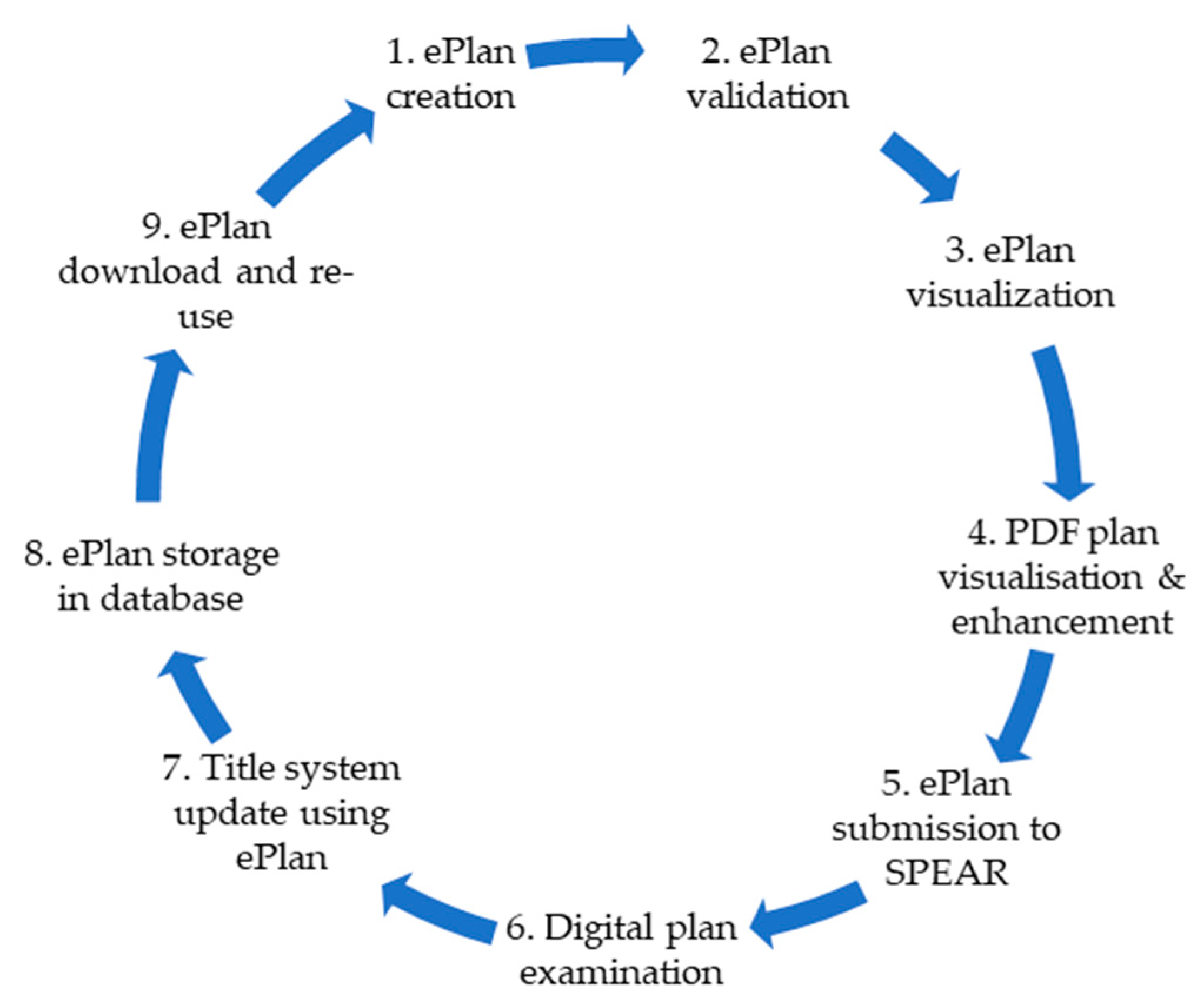
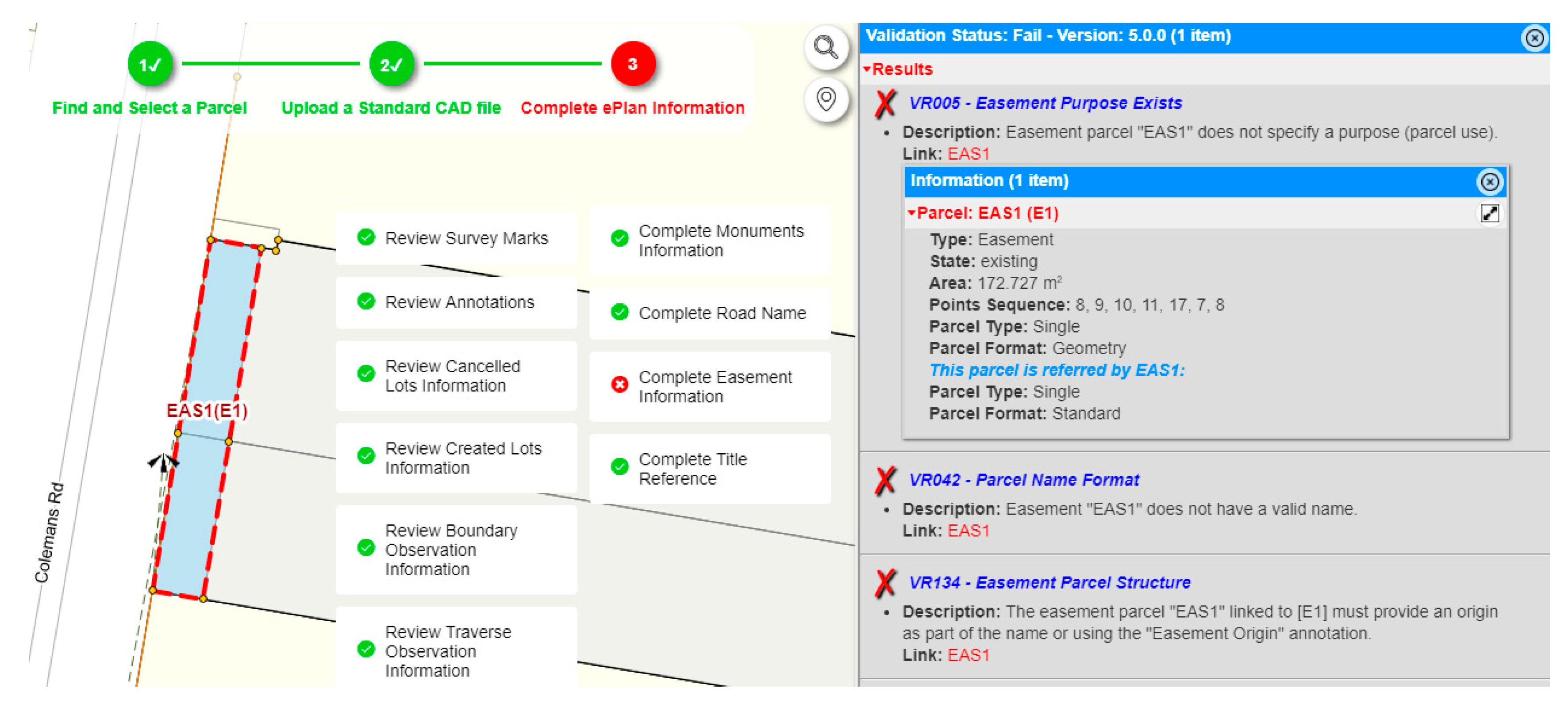
- ePlan validation service: This service identifies errors and potential problems in plans at the early stage of preparation and allows surveyors to correct these issues prior to the plan examination process. This service results in a significant reduction in the number of plan refusals and requisitions. The validation service currently relies on 130 ePlan validation rules, which cover four main areas: the ‘ePlan schema compliancy’, ‘survey accuracy (e.g., parcel area, parcel observations closure)’, ‘survey examination rules (e.g., appropriate title connections)’, and ‘metadata completeness (e.g., easement purpose)’.
- ePlan visualization service: This service converts the ePlan LandXML file into a PDF plan. The PDF plan becomes the legal title diagram in Victoria.
- ePlan visualization enhancement tool: This tool allows surveyors to enhance the visualization of a PDF plan using the following main functions: adjust labels and arrows, create enlargement diagrams, define sheets, define exaggerations, and adjust title connections.
- ePlan data viewer: This service allows surveyors and plan examiners to visualize a LandXML file in different layers (e.g., points, observations and parcels) superimposed over the Victorian map base and aerial imagery.
- ePlan data storage: This service stores the registered ePlan LandXML files in a structured Oracle database, which allows the digital data to be made available for search, query, analysis, sharing, and reuse.
1.1. Research Problem
- Software packages are not user friendly and not all software companies have invested in ePlan (e.g., Bentley);
- The ePlan data entry required for creating an ePlan is labor-intensive and time consuming;
- Surveyors must have access to the latest version of the ePlan software package, which enforces extra costs to surveying firms who need to subscribe for annual support and maintenance;
- Software packages do not recognize or minimize human errors, and
- Vendors need to regularly update their software with ongoing changes made to the ePlan protocol, enumerations, surveying regulations, LUV business policies, etc. However, their responsiveness to regularly keep their software up-to-date has been slow to unresponsive.
1.2. Research Aim
2. Relevant Experiences
2.1. New Zealand
2.2. Singapore
2.3. Australia
2.3.1. NSW
2.3.2. WA
2.4. Netherlands
3. Research Approach
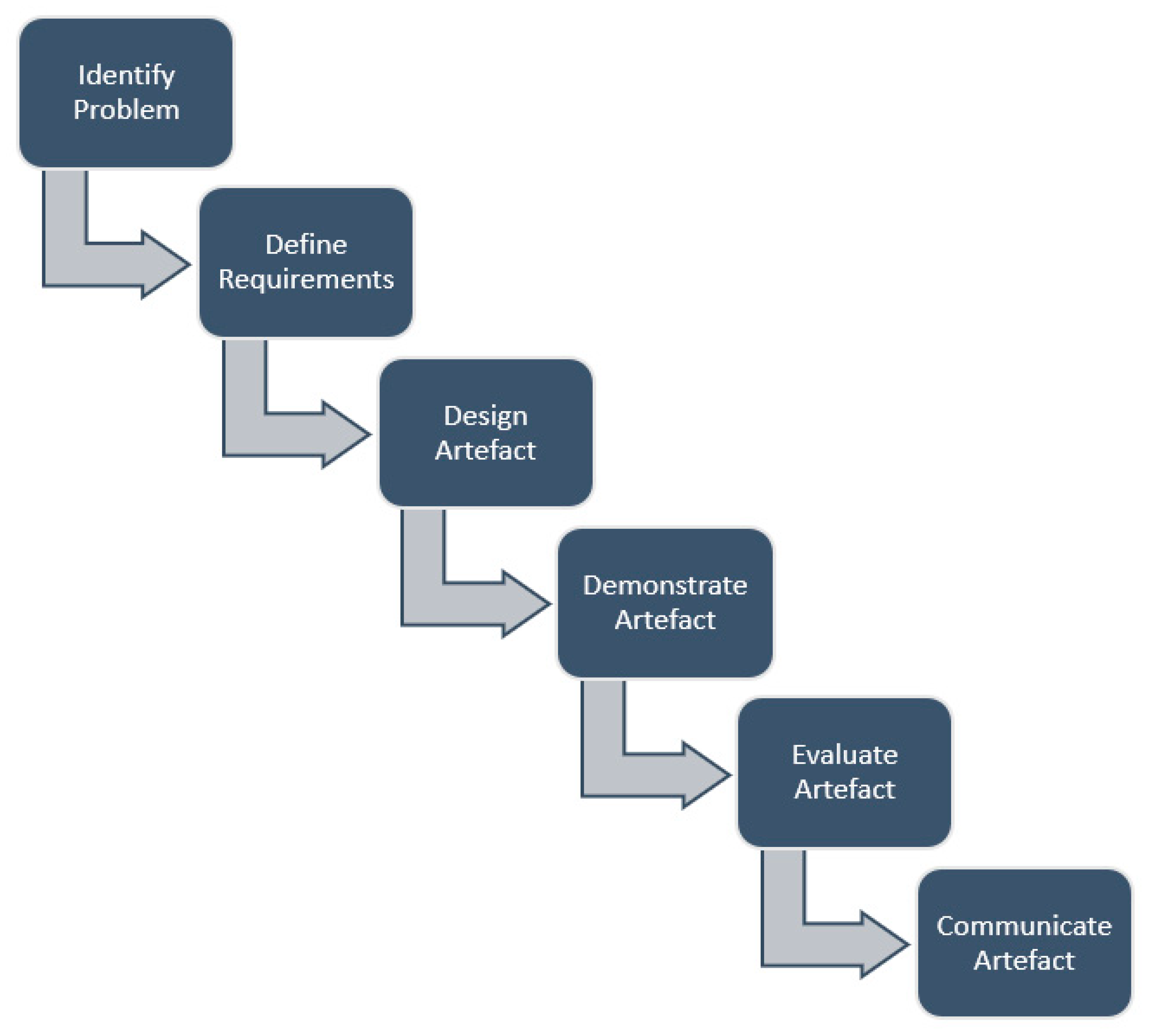
- Identify the research problem: The research problem has been identified by exploring the current practice for lodging cadastral plans in the land registry organization. The current practice for digital cadastral plans lodgment relies on various services including data creation, validation, visualization, enhancement, examination, storage, and download. However, the problem is that these land registry services have been developed in separate environments which may not be under the land registry’s control, and ongoing maintenance which makes the lodgment process difficult for land surveyors.
- Definition of the requirements of a solution: In this step, a set of important requirements are considered for developing the artefact that provides a feasible solution in response to the research problem. In the context of this research, the adopted approach for identifying requirements was based on a consultative workshop [68]. Consultative workshops are a specific form of participation mode, whereby people are consulted regarding their views prior to making any innovation [69]. In this phase, the business and technical requirements for designing and developing a single smart cadastral platform were gathered and documented. To identify the business and technical requirements, a series of consultative workshops with the Subdivision Branch at LUV were conducted. The Subdivision Branch is responsible for examining and registering plans under the Subdivision Act 1988. These requirements were presented to the surveying industry in different forums to receive their feedback.
- Design an artefact: A new integrated cadastral platform is designed as an artefact to address the research problem and to meet the requirements. This means that the constituent components of the integrated cadastral platform will be developed based on the requirements that are identified for integrating land registry services.
- Demonstration of the artefact: A proof of concept (PoC) is implemented to demonstrate the feasibility of the artefact designed for responding to the research problem. The proof of concept is an instance of the artefact that is applied to a suitable case study.
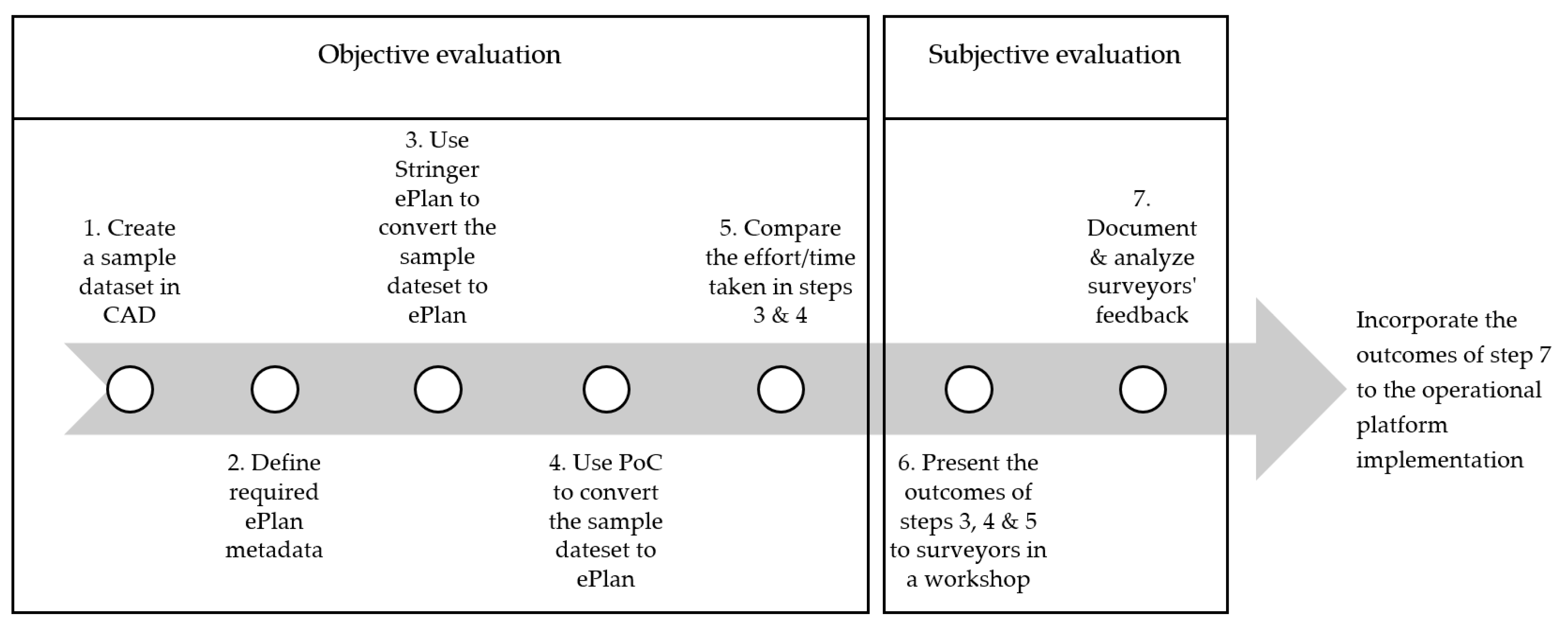
- Evaluation of the artefact: The evaluation mainly specifies how well the artefact solves the explicated problem. In this research, two types of evaluation strategies are adopted, namely subjective and objective [70]. Objective evaluation refers to a process that is purely based on quantifiable evidence. However, subjective evaluation refers to experts’ perspectives or opinions about the developed artefact.
- Communication of the artefact: Finally, the results of a design science research work are communicated to the researchers and practitioners. This paper is a form of communication of an integrated cadastral platform developed as a new artefact in the cadastral research domain.
4. Conceptual Design
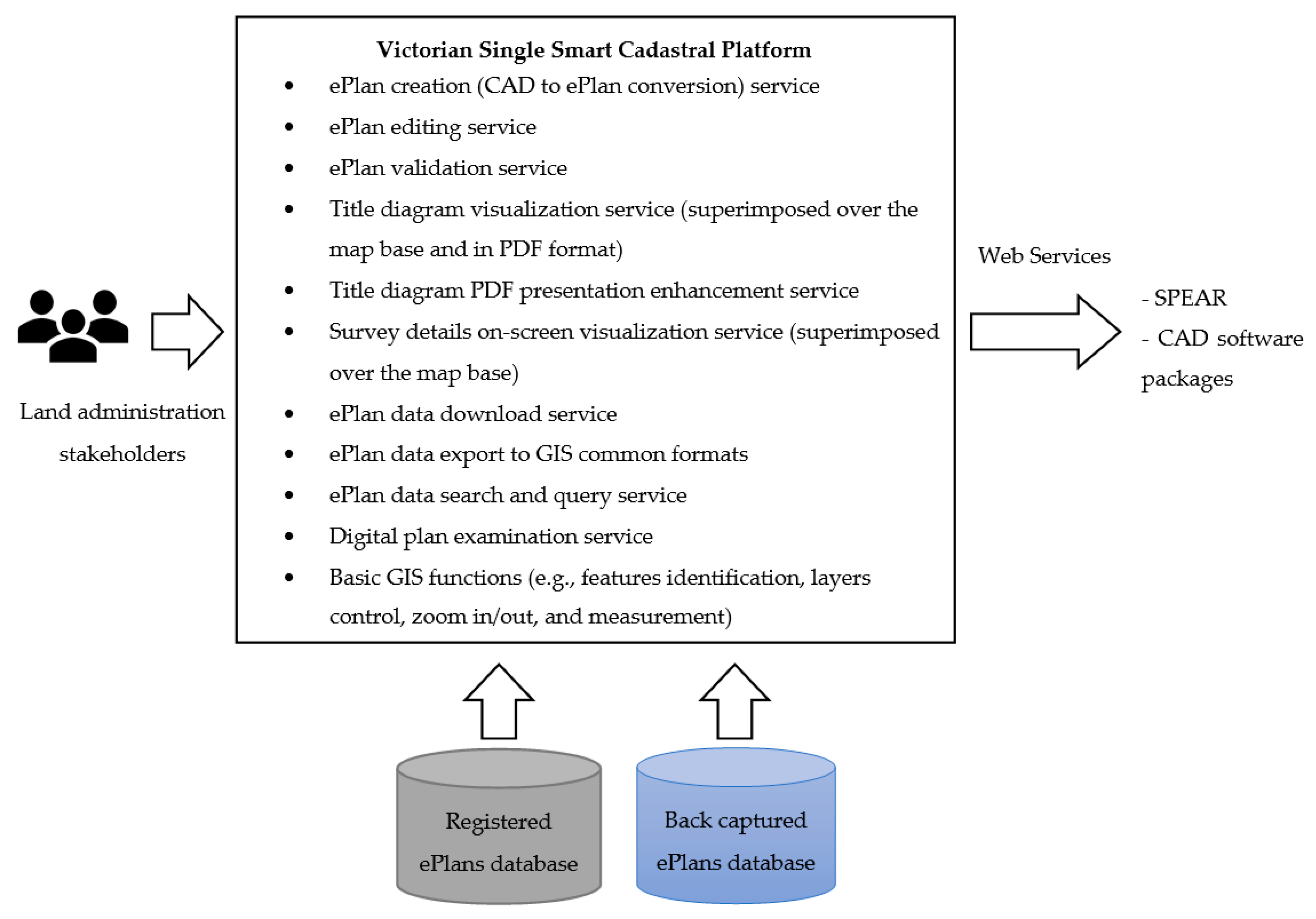
- Developing a single online platform that provides users (land administration stakeholders i.e., surveyors, councils, referral authorities, LUV) with access to the relevant smart cadastral services for managing submissions of ePlan. Services to be incorporated include digital cadastral data (ePlan) creation, validation, title diagram visualization (presented digitally on screen and in PDF format) and visualization enhancement, survey details on-screen visualization, ePlan data download, export, search and query, digital plan examination, as well as basic GIS functions (e.g., features identification, layers control, zoom in/out, and measure).
- A platform that interacts with the digital plan lodgment portal through web services.
- The platform should be based on profile access relevant to a user’s role.
- The creation of an ePlan should be undertaken by surveyors in an efficient and easy manner.
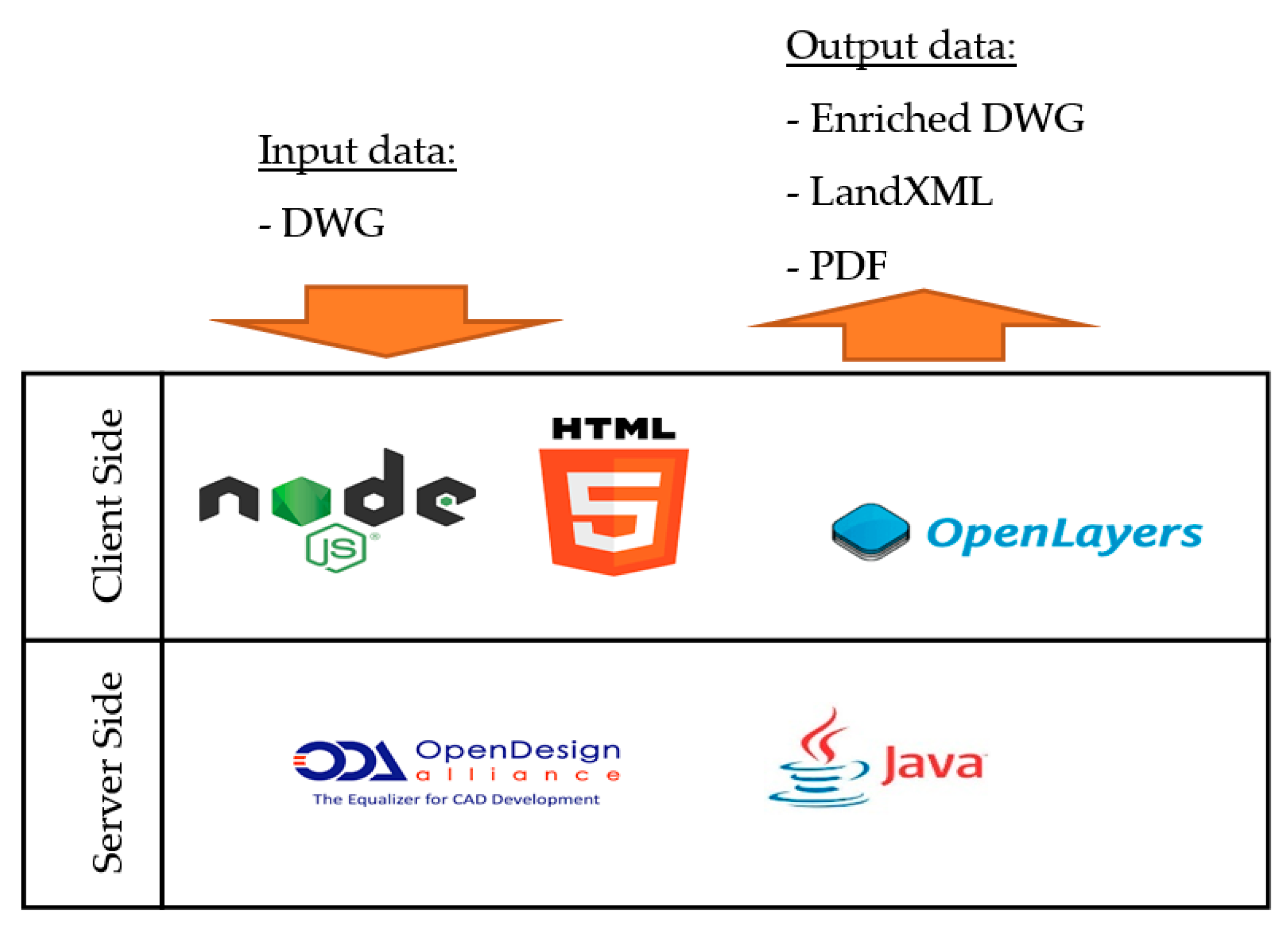
- As LUV is in the process of standardizing a CAD file format for cadastral plan lodgments, the platform should be able to convert the standard CAD file into LandXML format.
- The platform should support the automation of ePlan metadata entry by extracting data from existing LUV system databases through web services.
- The platform should provide an interactive validation report in a manner that highlights elements of the ePlan causing error on the map base and screen for better interpretation.
- The platform should provide users with access to registered ePlans stored in the Oracle database as well as ePlan files back-captured through the DCM project for visualization, query and download purposes.
- The platform should support exporting data to GIS common formats, e.g., shapefile, KML, GeoJSON.
- The platform should expose the ePlan web services to software vendors, so that those services can be consumed into CAD software packages.
- Licensed surveyor’s name and registration number from the Surveyors Registration Board of Victoria (SRBV) web service;
- Geometry and attributes of the cadastral plan and survey components recorded in CAD standard layers (through a mapping between the CAD layers and LandXML components);
- Coordinate system, subdivided parcel identifier and address, administrative areas, Crown description, and abutting parcels information (e.g., road connections) from a Vicmap web service;
- Survey marks and monuments information from the Survey Marks Enquiry Service (SMES) web service which provides free and online access to registered survey control mark information managed by LUV;
- Title reference number (volume/folio) from the Victorian Online Title System (VOTS) web service, which provides access to a record of all Victorian titles.
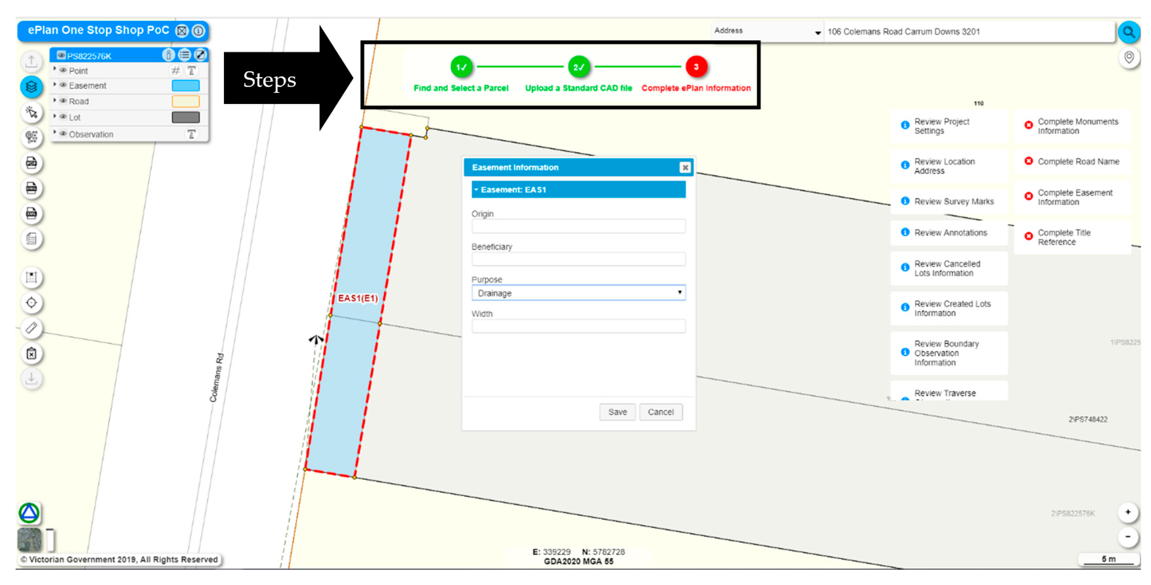
5. PoC Development
- ePlan creation (CAD to ePlan conversion) service;
- ePlan editing service;
- ePlan validation service;
- Title diagram visualization service (in PDF format);
- ePlan data download service;
- ePlan data search service;
- Basic GIS functions (e.g., features identification, layers control, zoom in/out, and measurement).
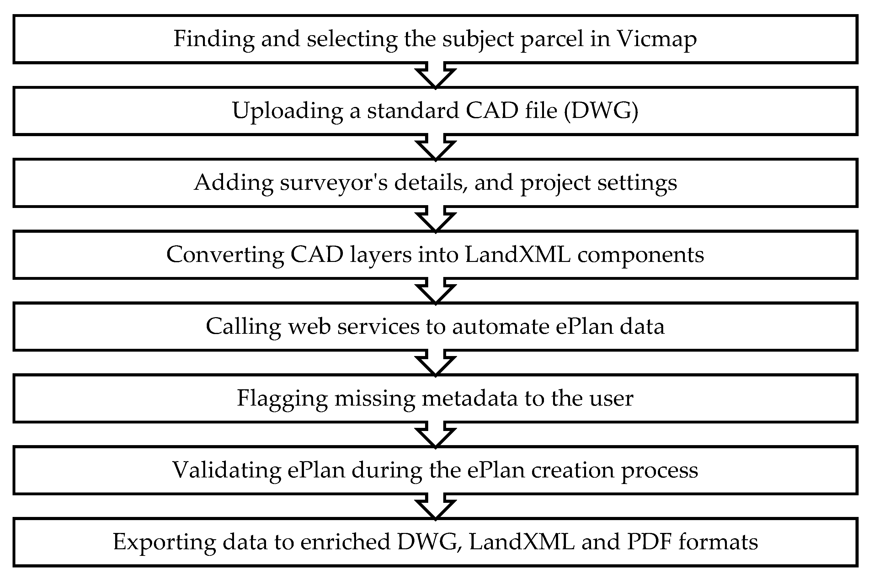
- Enriched DWG—a DWG file that contains ePlan metadata along with geometries;
- LandXML—for submission to SPEAR;
- PDF—title diagram visualized in PDF format.
6. PoC Evaluation
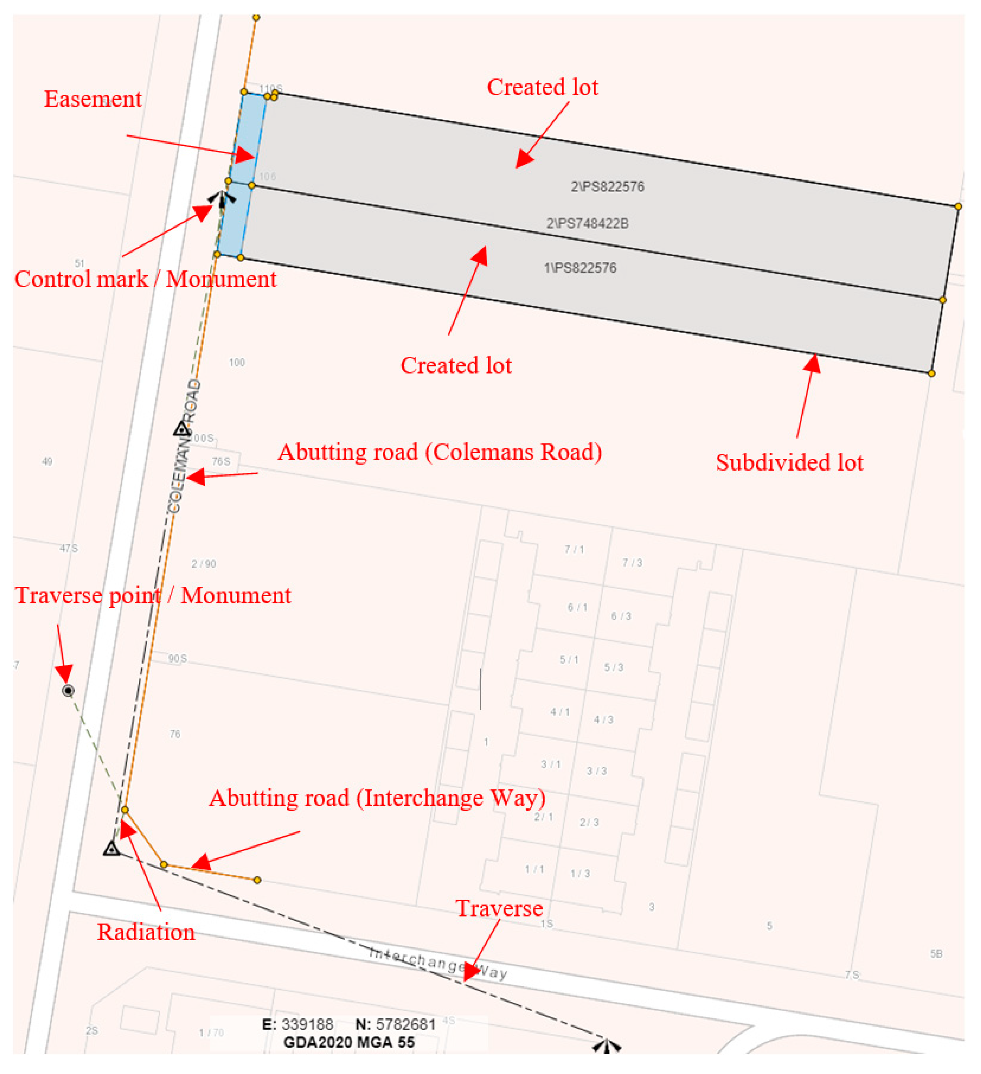
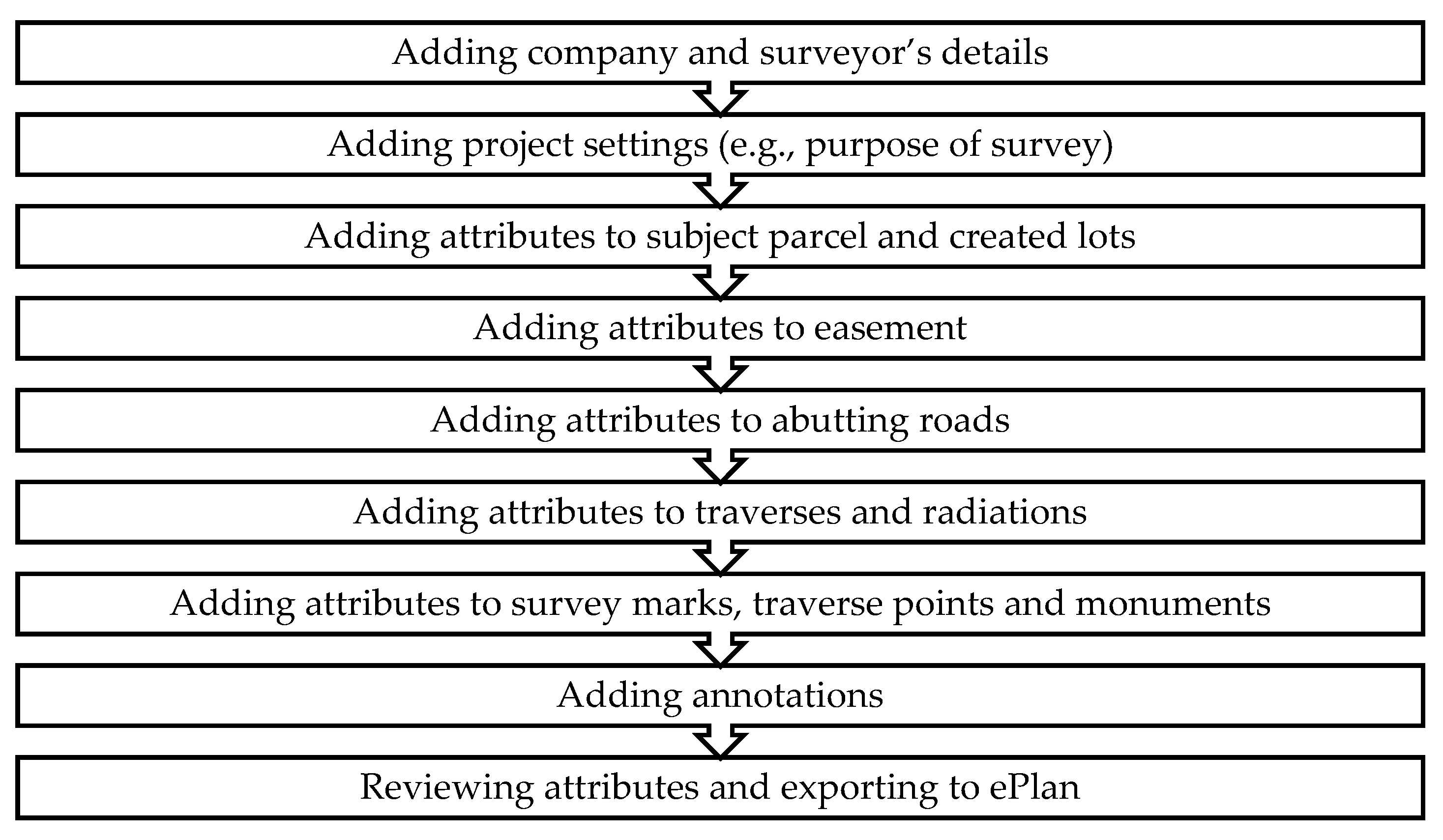
- Plan details (e.g., Plan Number, Act, Dealing Type, Surveyor’s details, administrative areas);
- Subject parcel details (Standard Parcel Identifier (SPI), parcel state (cancelled), parcel class (lot), address, area, title identifier (volume/folio));
- Created lots details (SPI, parcel state (created), parcel class (lot), area);
- Abutting roads details (parcel state (existing), parcel class (road), road name);
- Traverses details (line type (traverse), distance, bearing);
- Radiations details (line type (radiation), distance, bearing);
- Traverse points details (point state (e.g., existing, new), point type (traverse));
- Control marks details (e.g., identifier, description, creation date, status);
- Monuments (monument state (e.g., existing, new), monument condition (e.g., OK, replaced), monument type (e.g., nail, peg);
- Easement details (identifier, origin, beneficiary, width, purpose (e.g., drainage));
- Annotations (e.g., Crown details, general plan notation).
- The purpose of creating a PDF plan from ePlan was queried. Moving towards a fully digital workflow was suggested.
- Consideration should be given to the digital data copyright issues.
- It was suggested that DXF (Drawing eXchange Format developed by Autodesk for enabling data interoperability between AutoCAD and other programs) might be a better option than DWG as the file format for ePlan creation, since DWG is a proprietary file format, while DXF is an open data format.
- xdata mechanism used in the PoC for metadata storage may be broken in non-AutoCAD software applications (e.g., LISCAD). This needs further investigation and possibly, an alternative mechanism should be selected or developed.
- The allowance for provisional plans creation should be considered in the platform, as surveyors usually create multiple versions of the cadastral plan during the lifespan of a project.
- Metadata need to be preserved in the platform for the next versions of the CAD file.
- Bringing in plan and surveyor’s information from digital plan lodgment portal (SPEAR) to the platform is required to maximize consistency and lower errors.
- The usability of the platform needs to be evaluated by the users before the production release.
- Service continuity should be considered. The down time of the platform should be minimized.
7. Discussion
8. Conclusions
Author Contributions
Funding
Acknowledgments
Conflicts of Interest
References
- ICSM Cadastre 2034-Powering Land & Real Property. Available online: https://www.icsm.gov.au/sites/default/files/Cadastre2034_0.pdf (accessed on 2 November 2019).
- FIG International Federation of Surveyors (1995) Statement of the Cadastre. Available online: https://www.fig.net/resources/publications/figpub/pub11/figpub11.asp#2 (accessed on 8 January 2020).
- Gulliver, T.; Haanen, A.; Goodin, M. A 3D digital cadastre for New Zealand and the international opportunity. ISPRS Int. J. Geo-Inf. 2017, 6, 375. [Google Scholar] [CrossRef] [Green Version]
- Soon, K.H. A conceptual framework of representing semantics for 3D Cadastre in Singapore. In Proceedings of the 3rd International Workshop on 3D Cadastres, Shenzhen, China, 25–26 October 2012; pp. 361–379. [Google Scholar]
- Rajabifard, A.; Agunbiade, M.; Kalantari, M.; Yip, K.M.; Atazadeh, B.; Badiee, F.; Isa, D.M.N.B.; Adimin, M.K.B.; Chan, K.L.; Aien, A.; et al. An LADM-based Approach for Developing and Implementing a National 3D Cadastre—A Case Study of Malaysia. In Proceedings of the 7th International FIG Workshop on the Land Administration Domain Model, Zagreb, Croatia, 12–13 April 2018; Lemmen, C., van Oosterom, P., Eds.; International Federation of Surveyors (FIG): Copenhagen, Denmark, 2018; pp. 47–66. [Google Scholar]
- Oldfield, J.; van Oosterom, P.; Beetz, J.; Krijnen, F.T. Working with Open BIM Standards to Source Legal Spaces for a 3D Cadastre. ISPRS Int. J. Geo Inf. 2017, 6, 351. [Google Scholar] [CrossRef] [Green Version]
- Stoter, J.; Ploeger, H.; Roes, R.; van der Riet, E.; Biljecki, F.; Ledoux, H.; Kok, D.; Kim, S. Registration of Multi-Level Property Rights in 3D in The Netherlands: Two Cases and Next Steps in Further Implementation. ISPRS Int. J. Geo-Inf. 2017, 6, 158. [Google Scholar] [CrossRef]
- Stoter, J.; Ploeger, H.; Roes, R.; van der Riet, E.; Biljecki, F.; Ledoux, H. First 3D Cadastral Registration of Multi-level Ownerships Rights in the Netherlands. In Proceedings of the 5th International FIG 3D Cadastre Workshop, Athens, Greece, 18–20 October 2016; International Federation of Surveyors (FIG): Athens, Greece, 2016; pp. 491–504. [Google Scholar]
- Ying, S.; Guo, R.; Li, L.; Chen, N.; Jia, Y. An uniform real-estate registration model for China. In Proceedings of the 6th International FIG 3D Cadastre Workshop, Delft, The Netherlands, 2–4 October 2018; International Federation of Surveyors (FIG): Delft, The Netherlands, 2018; pp. 421–448. [Google Scholar]
- Sladić, D.; Radulović, A.; Govedarica, M. Processes in Cadastre: Process Model for Serbian 3D Cadastre. In Proceedings of the 6th International FIG 3D Cadastre Workshop, Delft, The Netherlands, 2–4 October 2018; International Federation of Surveyors (FIG): Copenhagen, Denmark, 2018; pp. 39–56. [Google Scholar]
- Janečka, K.; Bydłosz, J.; Radulović, A.; Vučić, N.; Sladić, D.; Govedarica, M. Lessons learned from the creation of the LADM based country profiles. In Proceedings of the 7th LADM Workshop, Zagreb, Croatia, 12–13 April 2018; pp. 171–192. [Google Scholar]
- Yu, C.; Li, L.; He, B.; Zhao, Z.; Li, X. LADM-based modeling of the unified registration of immovable property in China. Land Use Policy 2017, 64, 292–306. [Google Scholar] [CrossRef]
- Zhuo, Y.; Ma, Z.; Lemmen, C.; Bennett, R.M. Application of LADM for the integration of land and housing information in China: The legal dimension. Land Use Policy 2015, 49, 634–648. [Google Scholar] [CrossRef]
- Janečka, K.; Souček, P. A Country Profile of the Czech Republic Based on an LADM for the Development of a 3D Cadastre. ISPRS Int. J. Geo-Inf. 2017, 6, 143. [Google Scholar] [CrossRef]
- Janečka, K.; Souček, P. Country Profile for the Cadastre of the Czech Republic based on LADM. In Proceedings of the 5th International FIG Workshop on 3D Cadastres, Athens, Greece, 18–20 October 2016; Oosterom, P., van Dimopoulou, E., Fendel, E.M., Eds.; International Federation of Surveyors (FIG): Copenhagen, Denmark, 2016; pp. 285–300. [Google Scholar]
- Mađer, M.; Matijević, H.; Roić, M. Analysis of possibilities for linking land registers and other official registers in the Republic of Croatia based on LADM. Land Use Policy 2015, 49, 606–616. [Google Scholar] [CrossRef] [Green Version]
- Mader, M.; Vucic, N.; Vranic, S.; Roic, M. Initial 3D Cadastre Registration in the Republic of Croatia by Cadastral Resurvey. In Proceedings of the 6th International FIG 3D Cadastre Workshop, Delft, The Netherlands, 2–4 October 2018; pp. 57–74. [Google Scholar]
- Vučić, N.; Mađer, M.; Roić, M.; Vranić, S. Towards a Croatian 3D cadastre based on the LADM. In Proceedings of the 4th International Workshop on Geoinformation Science: GeoAdvances 2017, Safranbolu, Turkey, 14–15 October 2017; pp. 399–409. [Google Scholar]
- Vučić, N.; Roić, M.; Kapović, Z. Examination of Compatibility Between the Croatian Land Administration System and LADM. In Developments in Multidimensional Spatial Data Models; Springer: Berlin/Heidelberg, Germany, 2013; pp. 155–171. [Google Scholar]
- Gkeli, M.; Potsiou, C.; Ioannidis, C. LADM-based Crowdsourced 3D Cadastral Surveying—Potential and Perspectives. In Proceedings of the 6th International FIG 3D Cadastre Workshop, Delft, The Netherlands, 2–4 October 2018; pp. 17–38. [Google Scholar]
- Kalogianni, E. Design of a 3D Multipurpose Land Administrative System for Greece in the Context of LADM. Master’s Thesis, National Technical University of Athens, Athens, Greece, 2015. [Google Scholar]
- Kitsakis, D.; Apostolou, C.; Dimopoulou, E. Three-dimensional cadastre modelling of customary real property rights. Surv. Rev. 2018, 50, 107–121. [Google Scholar] [CrossRef]
- Kim, S.; Kim, J.; Jung, J.; Heo, J. Development of a 3D Underground Cadastral System with Indoor Mapping for As-Built BIM: The Case Study of Gangnam Subway Station in Korea. Sensors 2015, 15, 30870–30893. [Google Scholar] [CrossRef] [PubMed] [Green Version]
- Lee, B.-M.; Kim, T.-J.; Kwak, B.-Y.; Lee, Y.; Choi, J. Improvement of the Korean LADM country profile to build a 3D cadastre model. Land Use Policy 2015, 49, 660–667. [Google Scholar] [CrossRef]
- Radulović, A.; Sladić, D.; Govedarica, M. Serbian profile of the land administration domain model. In Proceedings of the FIG Working Week 2017: Surveying the World Tomorrow—From Digitalisation to Augmented Reality, Helsinki, Finland, 26 May–2 June 2017; Volume 8698, pp. 1–13. [Google Scholar]
- Radulović, A.; Sladić, D.; Govedarica, M. Towards 3D Cadastre in Serbia: Development of Serbian Cadastral Domain Model. ISPRS Int. J. Geo-Inf. 2017, 6, 312. [Google Scholar] [CrossRef] [Green Version]
- Radulovic, A.; Sladic, D.; Govedarica, M.; Ristic, A.; Jovanovic, D. Towards 3D Utility Network Cadastre: Extended Serbian LADM Country Profile. In Proceedings of the 6th International FIG 3D Cadastre Workshop, Delft, The Netherlands, 2–4 October 2018; pp. 95–110. [Google Scholar]
- Jamil, H.; Mohd Noor, I.S.A.; CheeHua, T.; Chan, K.L.; Rahman, A.A.; Musliman, I.A.; Ujang, U.; Hassan, I.; Bernad, S.; Karim, H. Converting The Strata Building to LADM. In Proceedings of the Proceedings FIG Working Week 2017: Surveying the World of Tomorrow—From Digitalization to Augmented Reality, Helsinki, Finland, 26 May–2 June 2017; FIG (International Federation of Surveyors): Copenhaga, Dinamarca, 2017. [Google Scholar]
- Zulkifli, N.A.; Abdul Rahman, A.; Jamil, H.; Teng, C.H.; Tan, L.C.; Looi, K.S.; Chan, K.L.; Van Oosterom, P.J.M. Towards Malaysian LADM country profile for 2D and 3D cadastral registration system. In Proceedings of the 25th FIG Congress: Engaging the challenges, enhancing the relevance, Kuala Lumpur, Malaysia, 16–21 June 2014; FIG International Federation of Surveyors: Copenhagen, Denmark, 2014. [Google Scholar]
- Zulkifli, N.A.; Rahman, A.A.; van Oosterom, P. 3D Strata Objects Registration for Malaysia within the LADM Framework. In Proceedings of the 4th International Workshop on 3D Cadastres, Dubai, UAE, 9–11 November 2014; International Federation of Surveyors (FIG): Copenhagen, Denmark, 2014; pp. 379–389. [Google Scholar]
- Zulkifli, N.A.; Abdul Rahman, A.; van Oosterom, P.; Tan, L.C.; Jamil, H.; Teng, C.H.; Looi, K.S.; Chan, K.L. The importance of Malaysian Land Administration Domain Model country profile in land policy. Land Use Policy 2015, 49, 649–659. [Google Scholar] [CrossRef]
- Góźdź, K.J.; van Oosterom, P. Developing the information infrastructure based on LADM–the case of Poland. Surv. Rev. 2016, 48, 168–180. [Google Scholar] [CrossRef] [Green Version]
- Vandysheva, N.; Ivanov, A.; Pakhomov, S.; Spiering, B.; Stoter, J.E.; Zlatanova, S.; Van Oosterom, P.J.M. Design of the 3D Cadastre Model and Development of the Prototype in the Russian Federation. In Proceedings of the 2nd International Workshop on 3D Cadastres, Delft, The Netherlands, 16–18 November 2011; International Federation of Surveyors (FIG): Copenhagen, Denmark, 2011. [Google Scholar]
- Vandysheva, N.; Tikhonov, V.; Van Oosterom, P.J.M.; Stoter, J.E.; Ploeger, H.D.; Wouters, R.; Penkov, V. 3D Cadastre modelling in Russia. In Proceedings of the FIG Working Week 2011 “Bridging the Gap between Cultures” & 6th National Congress of ONIGT, Marrakech, Morocco, 18–22 May 2011; International Federation of Surveyors (FIG): Marrakech, Morocco, 2011. [Google Scholar]
- Griffith-Charles, C.; Sutherland, M.; Davis, D. Capturing Legal and Physical Boundary Differences in 3D Space—A Case Study of Trinidad and Tobago. In Proceedings of the 5th International FIG Workshop on 3D Cadastres, Athens, Greece, 18–20 October 2016; Oosterom, P., van Dimopoulou, E., Fendel, E.M., Eds.; International Federation of Surveyors (FIG): Copenhagen, Denmark, 2016; pp. 433–446. [Google Scholar]
- Alkan, M.; Polat, Z.A. Analysis of Studies on the Land Administration Domain Model in Turkey. In Proceedings of the 7th Land Administration Domain Model Workshop (LADM2018), Zagreb, Croatia, 11–13 April 2018; pp. 213–222. [Google Scholar]
- Aydinoglu, A.C.; Bovkir, R. Generic land registry and cadastre data model supporting interoperability based on international standards for Turkey. Land Use Policy 2017, 68, 59–71. [Google Scholar] [CrossRef]
- Polat, Z.A.; Alkan, M. Design and implementation of a LADM-based external archive data model for land registry and cadastre transactions in Turkey: A case study of municipality. Land Use Policy 2018, 77, 249–266. [Google Scholar] [CrossRef]
- Stubkjaer, E. A comparison of LandXML, ISO 19152:2012 LADM, and the draft LandInfra conceptual model. In Proceedings of the Geospatial-BIM-Indoor Workshop, Boulder, CO, USA, 2 June 2015. [Google Scholar]
- Pouliot, J.; Monney, C.; Ingensand, J.; Larrivée, S. How to quickly detect the overlap and the consistency between LADM with LandInfra and LandXML. In Proceedings of the 8th International FIG workshop on the Land Administration Domain Model, Kuala Lumpur, Malaysia, 1–3 October 2019. [Google Scholar]
- Olfat, H.; Shojaei, D.; Briffa, M. The Victorian digital Cadastre: Challenges and investigations. In Proceedings of the 3rd Annual Conference of Research@Locate, Melbourne, Australia, 12–14 April 2016. [Google Scholar]
- Olfat, H.; Jani, A.; Shojaei, D.; Darvill, A.; Briffa, M.; Rajabifard, A.; Badiee, F. Tackling the challenges of visualising digital cadastral plans: The Victorian cadastre experience. Land Use Policy 2019, 83, 84–94. [Google Scholar] [CrossRef]
- Olfat, H.; Shojaei, D.; Briffa, M.; Rajabifard, A. The Current Status and Ongoing Investigations of 2D and 3D Digital Cadastre (ePlan) in Victoria, Australia. In Proceedings of the Academic Research Stream at the Annual Conference Locate, Research@ Locate, Sydney, Australia, 3–6 April 2017. [Google Scholar]
- Olfat, H.; Shojaei, D.; Briffa, M.; Maley, S.; Rajabifard, A. Strategic actions for increasing the submission of digital cadastral data by the surveying industry based on lessons learned from Victoria, Australia. ISPRS Int. J. Geo Inf. 2018, 7, 47. [Google Scholar] [CrossRef] [Green Version]
- Victorian Government Subdivision Act. 1988. Available online: http://www6.austlii.edu.au/cgi-bin/viewdb/au/legis/vic/consol_act/sa1988153/ (accessed on 2 October 2019).
- Aien, A.; Rajabifard, A.; Kalantari, M.; Williamson, I.; Shojaei, D. Development of XML Schemas for Implementation of a 3D Cadastral Data Model. In Proceedings of the 4th International Workshop on 3D Cadastres, Dubai, UAE, 9–11 November 2014. [Google Scholar]
- Shojaei, D.; Olfat, H.; Aien, A.; Nimorakiotakis, N.; Rajabifard, A. Utilising Virtual and Augmented Reality Technologies to Improve the Visualisation of Digital Cadastre—The Victorian Cadastre Experience. In Proceedings of the 2nd International IAG Workshop on BIM and GIS Integration, 3D GeoInfo Conference 2019, Singapore, 25 September 2019. [Google Scholar]
- Shojaei, D.; Olfat, H.; Faundez, S.I.Q.; Kalantari, M.; Rajabifard, A.; Briffa, M. Geometrical data validation in 3D digital cadastre—A case study for Victoria, Australia. Land Use Policy 2017, 68, 638–648. [Google Scholar] [CrossRef]
- Shojaei, D.; Rajabifard, A.; Kalantari, M.; Bishop, I.D.; Aien, A. Design and development of a web-based 3D cadastral visualisation prototype. Int. J. Digit. Earth 2015, 8, 538–557. [Google Scholar] [CrossRef]
- Shojaei, D.; Olfat, H.; Rajabifard, A.; Darvill, A.; Briffa, M. Assessment of the Australian digital cadastre protocol (ePlan) in terms of supporting 3D building subdivisions. Land Use Policy 2016, 56, 112–124. [Google Scholar] [CrossRef]
- CSDILA. Victorian 3D Digital Cadastre Roadmap; Centre for SDIs and Land Administration (CSDILA) of the University of Melbourne: Melbourne, Australia, 2019. [Google Scholar]
- Victorian Government Digital Cadastre Modernization Project. Available online: https://www2.delwp.vic.gov.au/maps/digital-cadastre-modernisation-project/digital-cadastre-modernisation-project (accessed on 2 January 2020).
- Bevin, T. Cadastre 2014 Reforms in New Zealand. In Proceedings of the FIG Commission VII, Bay of Islands, New Zealand, 9–15 October 1999; p. 99. [Google Scholar]
- Haanen, A.; Bevin, T.; Sutherland, N. e-Cadastre-Automation of the New Zealand Survey System. In Proceedings of the FIG XXII International Congress, Washington, DC, USA, 19–26 April 2002; pp. 19–26. [Google Scholar]
- Haanen, A.; Gulliver, T. A Vision for a Fully Digital Cadastral Survey System. In Proceedings of the FIG Congress 2018 Embracing Our Smart World Where the Continents Connect: Enhancing the Geospatial Maturity of Societies, Istanbul, Turkey, 6–11 May 2018; International Federation of Surveyors (FIG): Istanbul, Turkey, 2018. [Google Scholar]
- Khoo, V. Towards “Smart Cadastre” that supports 3D parcels. In Proceedings of the 3rd International Workshop on 3D Cadastres: Developments and Practices, Shenzhen, China, 25–26 October 2012; pp. 25–26. [Google Scholar]
- Andreasson, K. Legal coordinated cadastres–theoretical concepts and the case of Singapore. In Proceedings of the FIG Congress 2006 Shaping the Change, Munich, Germany, 8–13 October 2006. [Google Scholar]
- Soon, K.H.; Tan, D.; Khoo, V. Initial Design to Develop a Cadastral System that Supports Digital Cadastre, 3D and Provenance for Singapore. In Proceedings of the 5th International FIG Workshop on 3D Cadastre, Athens, Greece, 18–20 October 2016; pp. 18–20. [Google Scholar]
- ICSM ePlan Model. Available online: https://www.icsm.gov.au/sites/default/files/ICSM-ePlan-Model-v1.0%281%29.pdf (accessed on 16 April 2020).
- Wady, V. An Investigation of Land and Property Information (NSW) Proposed E-Plan Process of Digital Survey Plan Lodgement in LandXML Format. 2009. Available online: https://eprints.usq.edu.au/8534/1/Wady_2009.pdf (accessed on 2 November 2019).
- El-Kiki, A. Thesis B: Software Ingestion of LandXML Files. Ph.D. Thesis, University of New South Wales Sydney, Kensington, Australia, 2017. [Google Scholar]
- Hancock, R.J. An Investigation into LandXML for Implementation of 3D Cadastre in eSurvey; University of Southern Queensland: Toowoomba, Australia, 2015. [Google Scholar]
- Kalantari, M.; Rajabifard, A.; Wallace, J.; Williamson, I.P. Toward e-land administration: Australian online land information services. In Proceedings of the SSC 2005 Spatial Intelligence, Innovation and Praxis: The national biennial Conference of the Spatial Sciences Institute, Melbourne, Australia, September 2005. [Google Scholar]
- Kruse, D. Public Service on the map: A Case History of PDOK; The Public Geodata Portal in The Netherlands! In Proceedings of the European Conference on Digital Government, Ljubljana, Slovenia, 16–17 June 2016; p. 335. [Google Scholar]
- Folmer, E.; Beek, W. Kadaster Data Platform-Overview Archicture. In Proceedings of the Free and Open Source Software for Geospatial (FOSS4G) Conference, Boston, MA, USA, 14–19 August 2017; Volume 17, p. 23. [Google Scholar]
- Johannesson, P.; Perjons, E. An Introduction to Design Science; Springer: Berlin/Heidelberg, Germany, 2014; ISBN 3319106317, 9783319106311. [Google Scholar]
- Çağdaş, V.; Stubkjær, E. Design research for cadastral systems. Comput. Environ. Urban Syst. 2011, 35, 77–87. [Google Scholar] [CrossRef]
- Ørngreen, R.; Levinsen, K. Workshops as a Research Methodology. Electron. J. E-learn. 2017, 15, 70–81. [Google Scholar]
- Cornwall, A.; Jewkes, R. What is participatory research? Soc. Sci. Med. 1995, 41, 1667–1676. [Google Scholar] [CrossRef]
- Ge, J.; Hokao, K. Residential environment index system and evaluation model established by subjective and objective methods. J. Zhejiang Univ. A 2004, 5, 1028–1034. [Google Scholar] [CrossRef] [PubMed]
- Open Design Alliance Open Design Alliance Software Development Kit. Available online: https://www.opendesign.com/products (accessed on 3 January 2020).


| Sub-Domain | LandXML | LADM |
|---|---|---|
| Parcel | Parcels Parcel Parcel+parcelType | LA_BAUnit LA_Parcel LA_LegalSpaceBuildingUnit LA_LegalSpaceUtilityNetwork |
| CoordinateGeometry::CoordGeom | LA_Point LA_BoundaryFaceString LA_BoundaryFace | |
| CoordinateGeometry::Center Parcel+area Parcel+volume | LA_Parcel+referencePoint LA_Parcel+area LA_Parcel+volume | |
| Naming/identifying spatial objects | Parcel+buildingLevelNo Parcel+buildingNo Parcel+name Parcel+refer.ces(LocationAddress) Parcel+references (Title) Parcel+taxid | ~ LA_Parcel+extAddressID LA_LegalSpaceBuildingUnit+extPhys.Build.UnitID LA_Parcel+suID LA_Parcel+extAddressID |
| Document | Core::FieldNote SurveyHeader | LA_Party (Survey and FieldNote author) LA_AdministrativeSource LA_SpatialSource |
| Legal/administrative aspects | Parcel+liabilityApportionment Parcel+lotEntitlements Parcel+owner Parcel+setbackF..R..S Parcel+state Parcel+useOfParcel | Not supported LA_PartyMember+share LA_Party (as owner) LA_Restriction (~easement) LA_Restriction (~easement) |
| Features of terrain objects and project elements | Core::Feature SurveyMonument | LA_Point+monumentation |
| Jurisdiction\Criterion | Data Creation | Visualization | Validation | Enhancement | Examination | Database Storage | Data Download |
|---|---|---|---|---|---|---|---|
| New Zealand | − | + | + | + | + | + | + |
| Singapore | − | + | + | + | + | + | + |
| NSW | − | + | + | − | + | − | + |
| WA | Only modifications | + | + | + | − | + | + |
| The Netherlands | − | + | + | − | − | + | + |
| Action–Metadata Entry for: | Stringer ePlan | PoC |
|---|---|---|
| Plan details | Manual entry required | Manual entry required |
| Subject parcel | Manual entry required | Automatic using Vicmap web service |
| Created lots | Manual entry required | Automatic using CAD layers |
| Abutting roads | Manual entry required | Automatic using Vicmap web service |
| Traverses | Manual entry required | Automatic using CAD layers |
| Radiations | Manual entry required | Automatic using CAD layers |
| Traverse points | Manual entry required | Manual entry required |
| Control marks | Manual entry required | Automatic using SMES web service |
| Monuments | Manual entry required | Manual entry required only for survey marks unavailable in SMES |
| Easement | Manual entry required | Manual entry required |
| Annotations | Manual entry required | Manual entry required |
| Total time | 20 min | 4 min |
© 2020 by the authors. Licensee MDPI, Basel, Switzerland. This article is an open access article distributed under the terms and conditions of the Creative Commons Attribution (CC BY) license (http://creativecommons.org/licenses/by/4.0/).
Share and Cite
Olfat, H.; Atazadeh, B.; Rajabifard, A.; Mesbah, A.; Badiee, F.; Chen, Y.; Shojaei, D.; Briffa, M. Moving Towards a Single Smart Cadastral Platform in Victoria, Australia. ISPRS Int. J. Geo-Inf. 2020, 9, 303. https://doi.org/10.3390/ijgi9050303
Olfat H, Atazadeh B, Rajabifard A, Mesbah A, Badiee F, Chen Y, Shojaei D, Briffa M. Moving Towards a Single Smart Cadastral Platform in Victoria, Australia. ISPRS International Journal of Geo-Information. 2020; 9(5):303. https://doi.org/10.3390/ijgi9050303
Chicago/Turabian StyleOlfat, Hamed, Behnam Atazadeh, Abbas Rajabifard, Afshin Mesbah, Farshad Badiee, Yiqun Chen, Davood Shojaei, and Mark Briffa. 2020. "Moving Towards a Single Smart Cadastral Platform in Victoria, Australia" ISPRS International Journal of Geo-Information 9, no. 5: 303. https://doi.org/10.3390/ijgi9050303
APA StyleOlfat, H., Atazadeh, B., Rajabifard, A., Mesbah, A., Badiee, F., Chen, Y., Shojaei, D., & Briffa, M. (2020). Moving Towards a Single Smart Cadastral Platform in Victoria, Australia. ISPRS International Journal of Geo-Information, 9(5), 303. https://doi.org/10.3390/ijgi9050303