GIS-Based Modeling for Selection of Dam Sites in the Kurdistan Region, Iraq

 ,
,  ,
,  , and
, and 
Abstract
1. Introduction
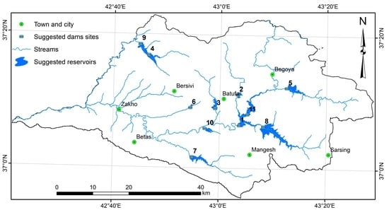
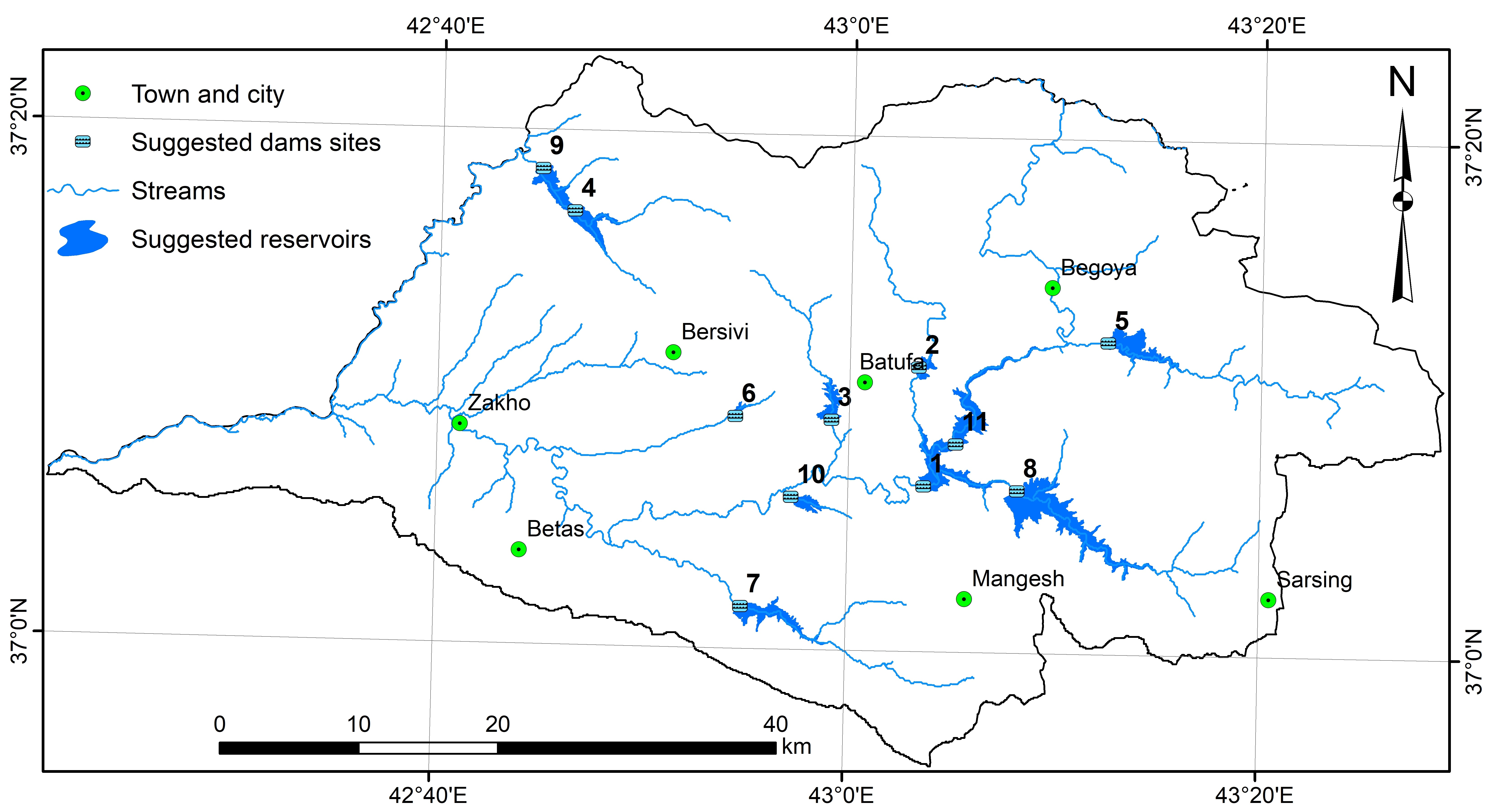
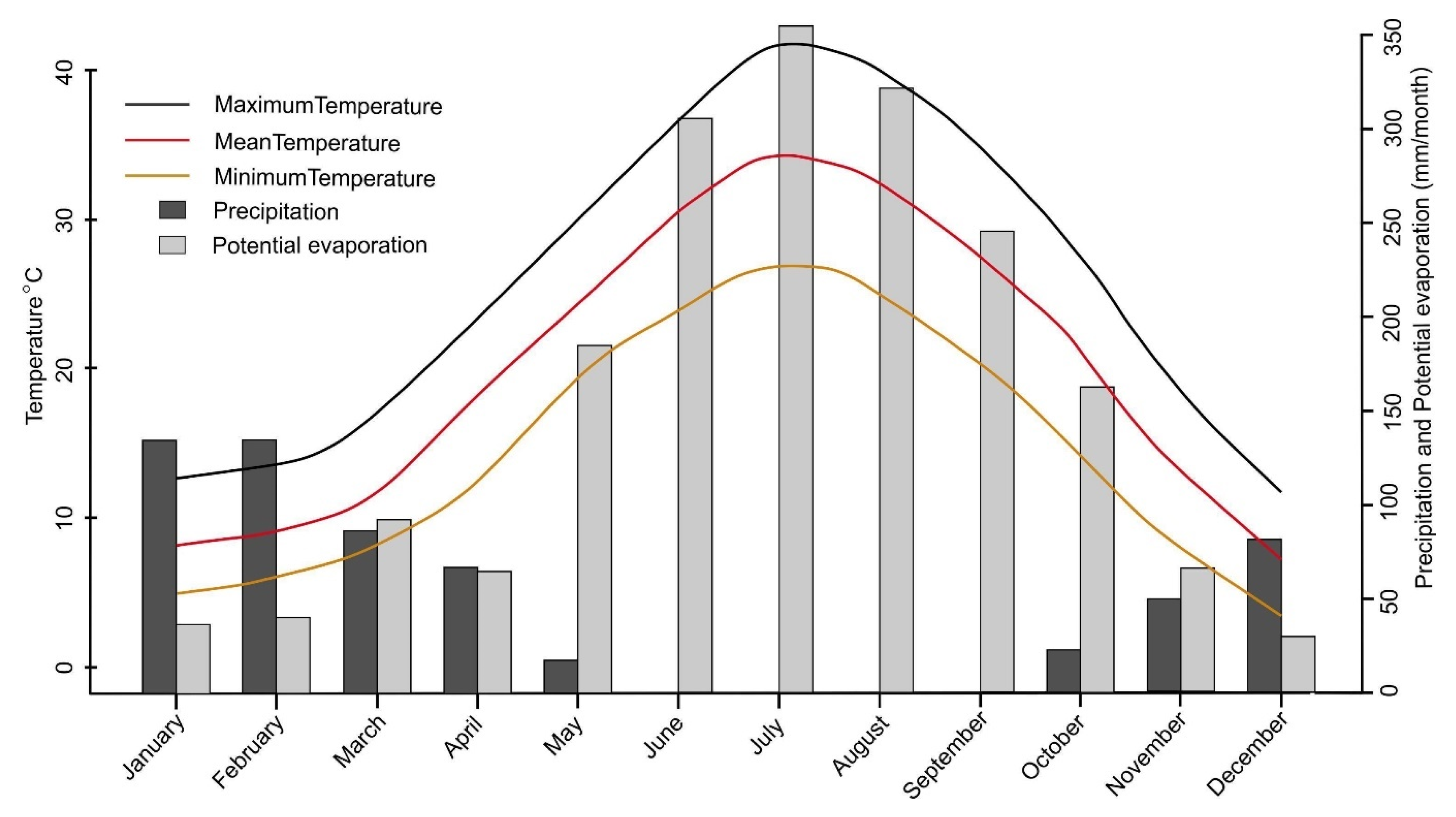
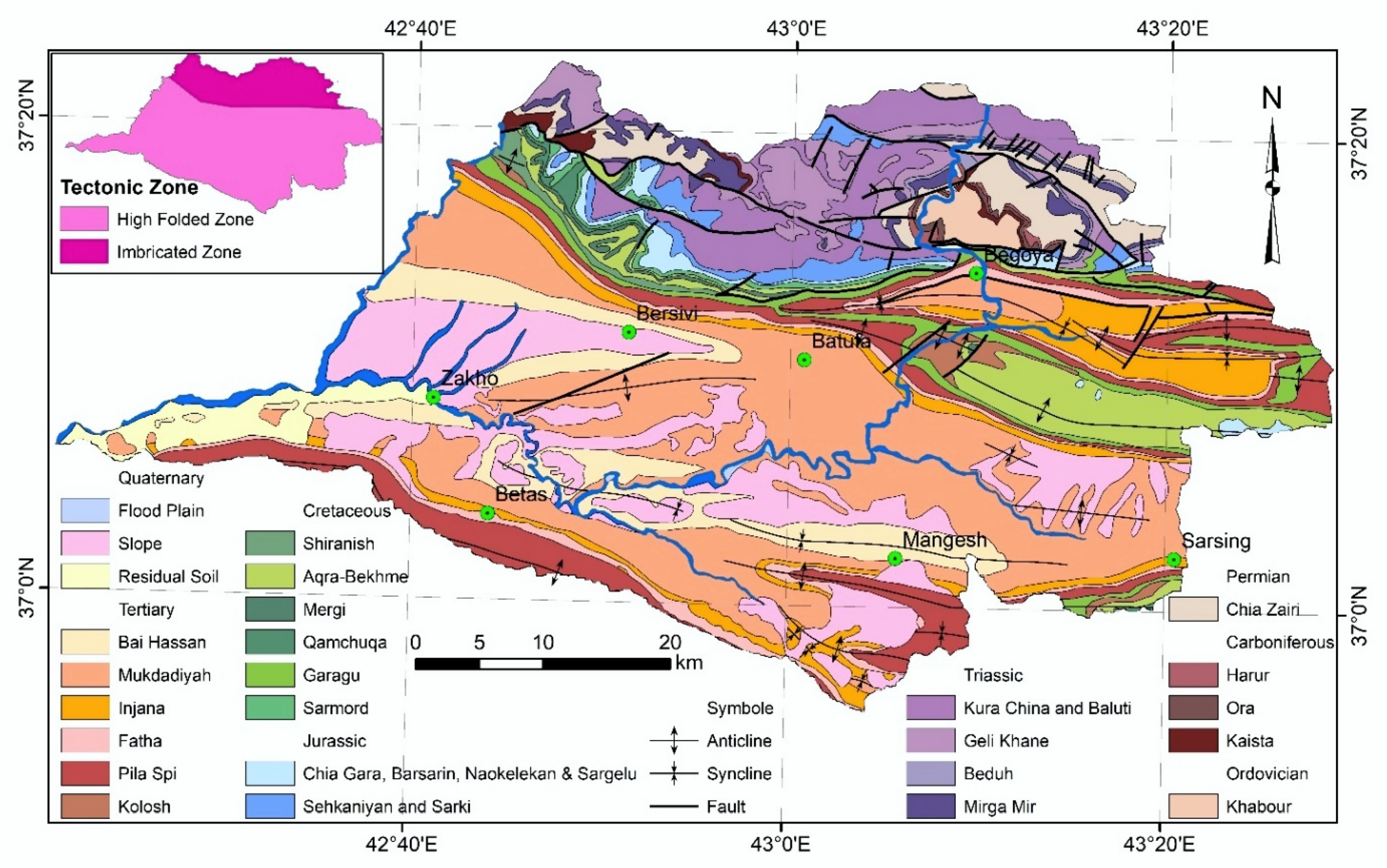
2. Study Area
3. Methodology
3.1. Preparation of Input
3.2. Suitable Dam Site Selection Model
3.2.1. Weighted Sum Method (WSM)
3.2.2. Analytic Hierarchy Process (AHP)
3.2.3. Accuracy Assessment and Dam Site Selection
4. Predictive factors
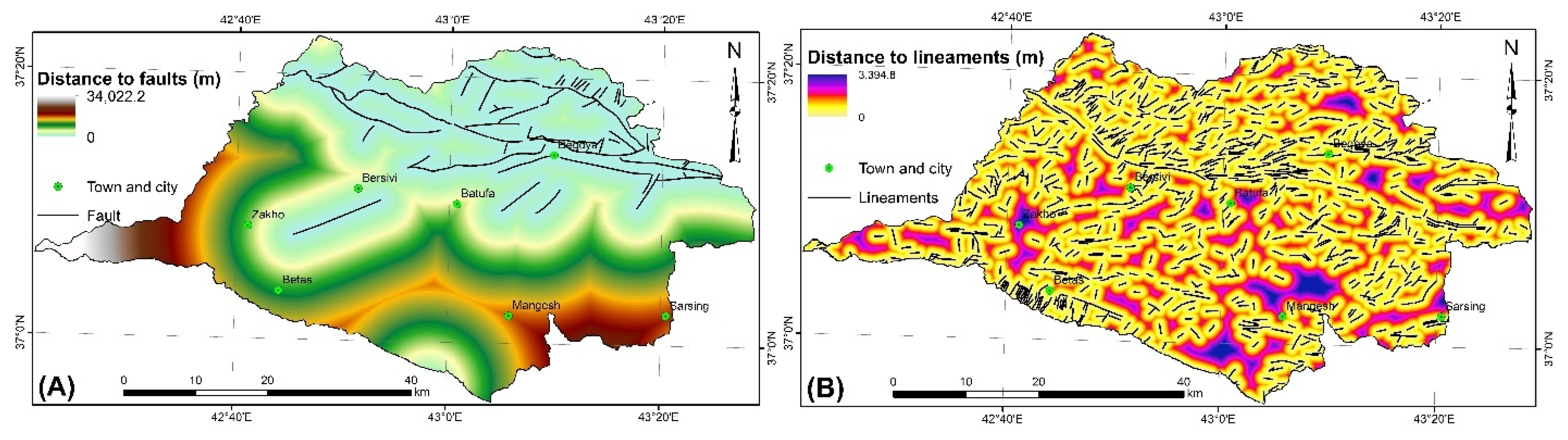
4.1. Geological Factors
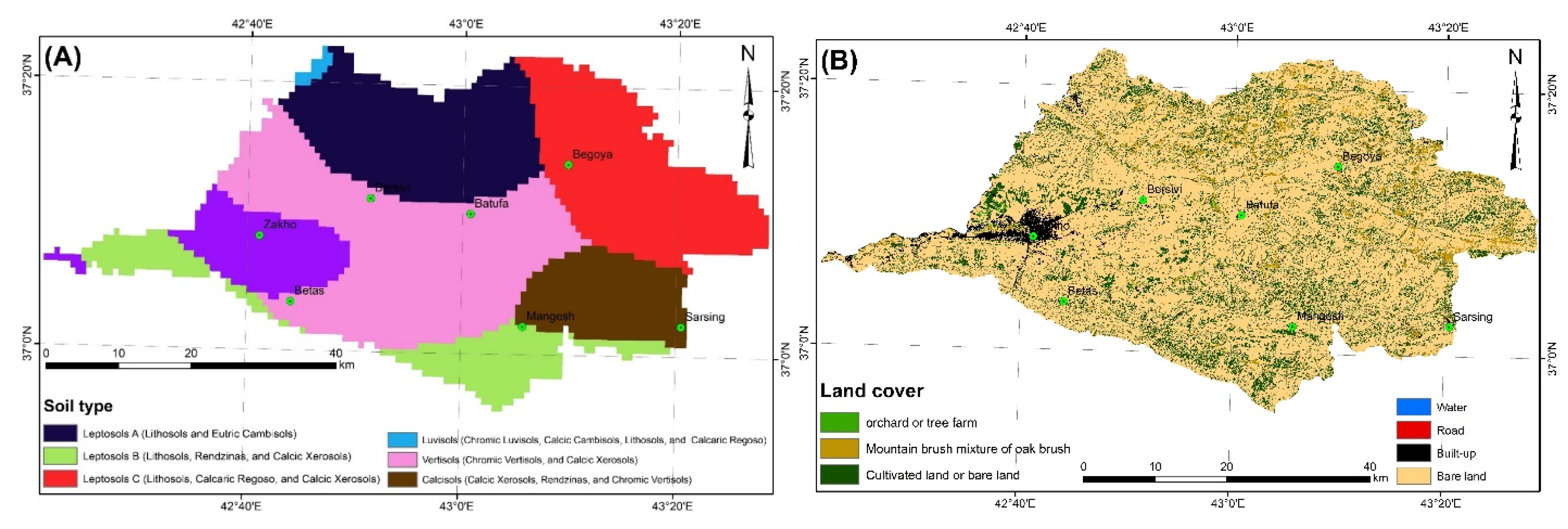
4.2. Environmental Factors
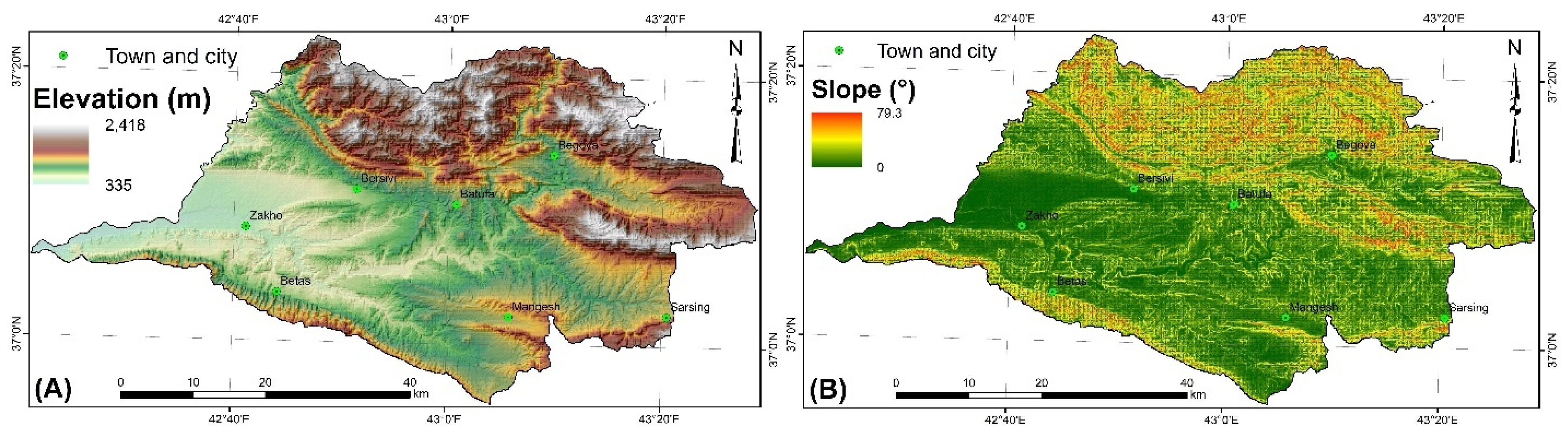
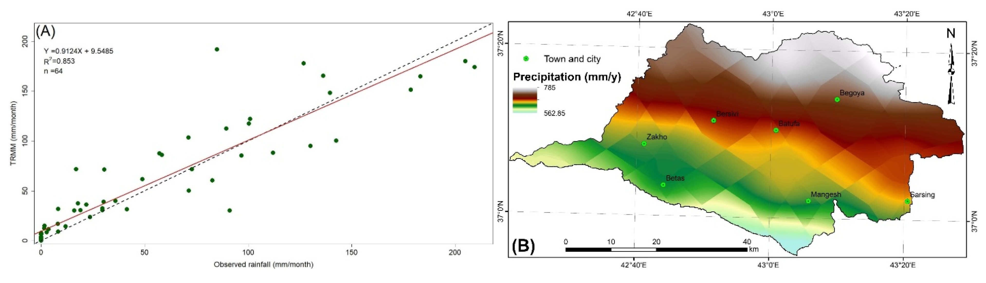
4.3. Topographical Factors
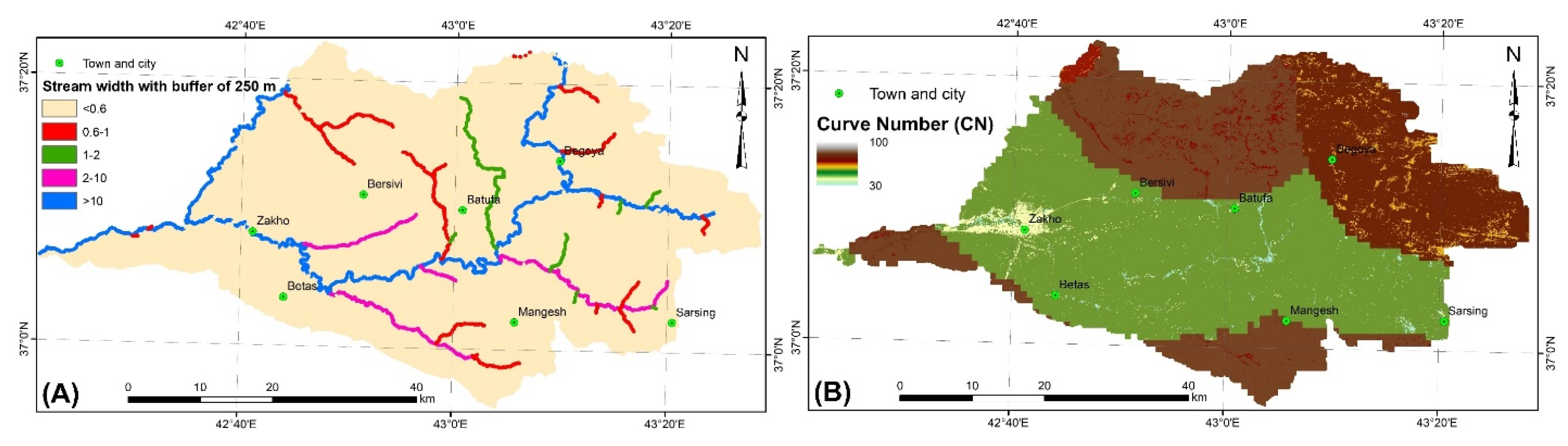
4.4. Hydrological Factors
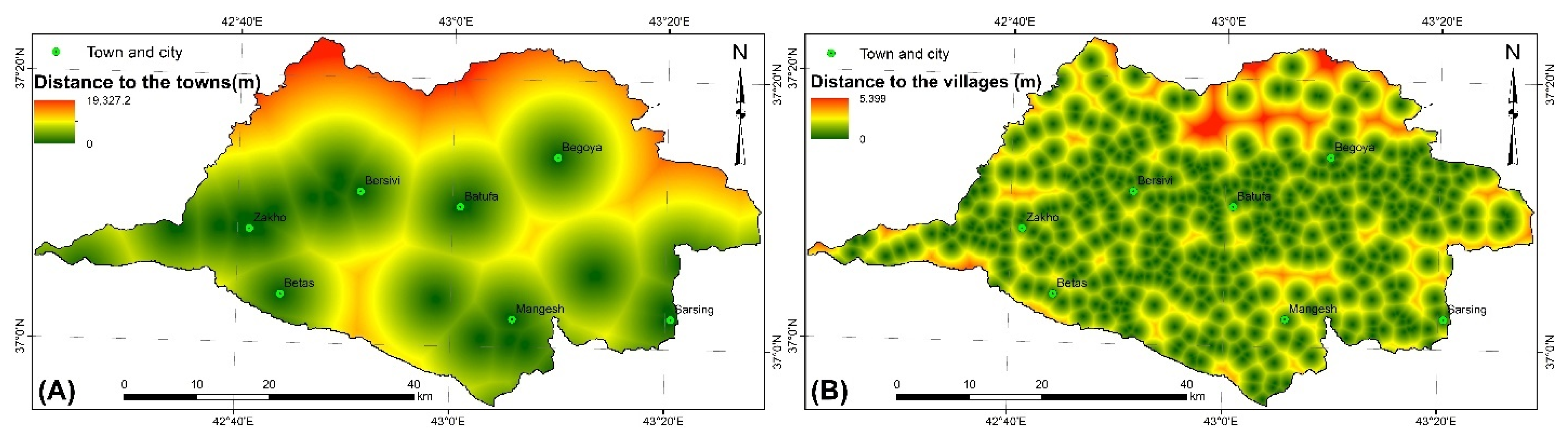
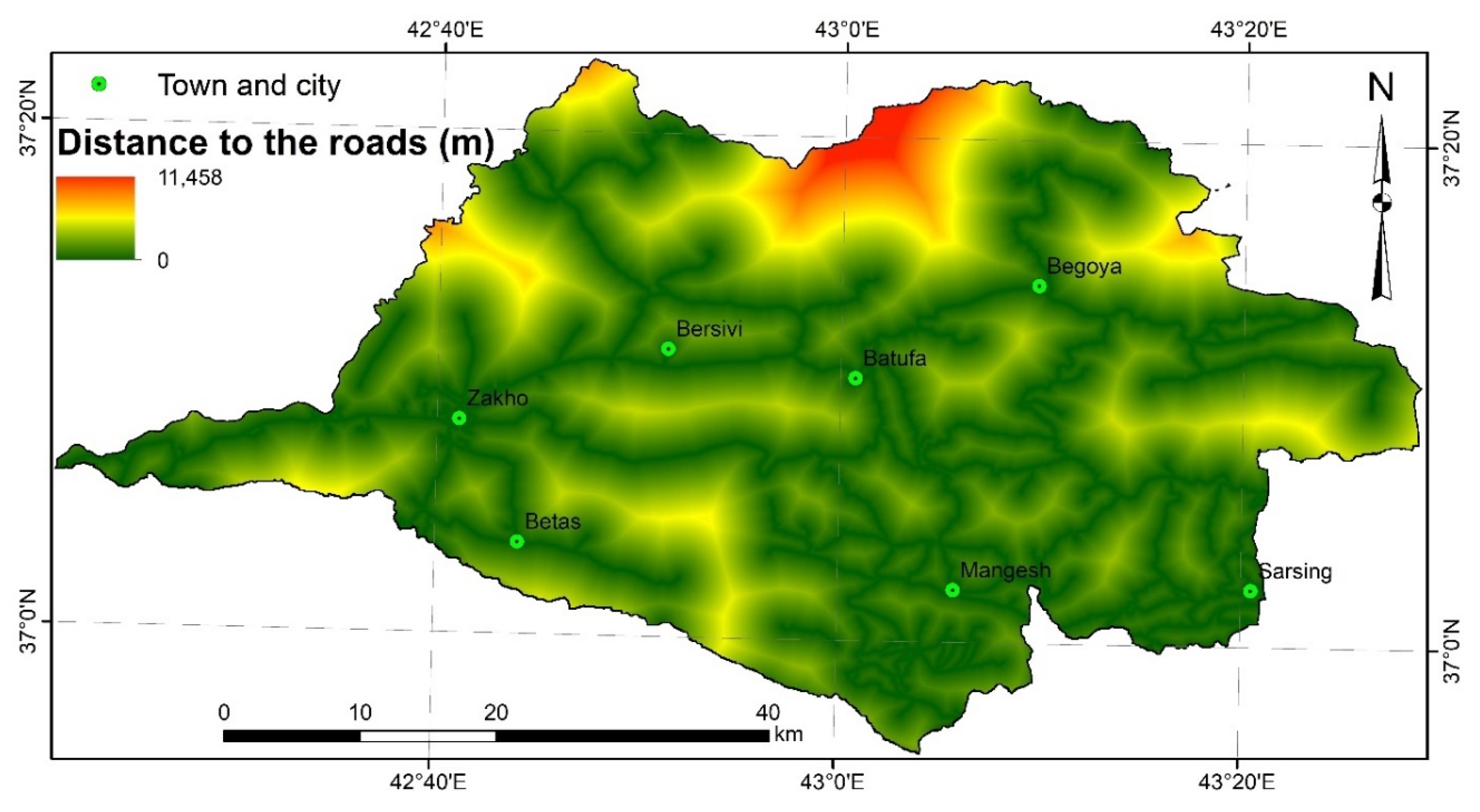
4.5. Socioeconomics Factors
5. Results
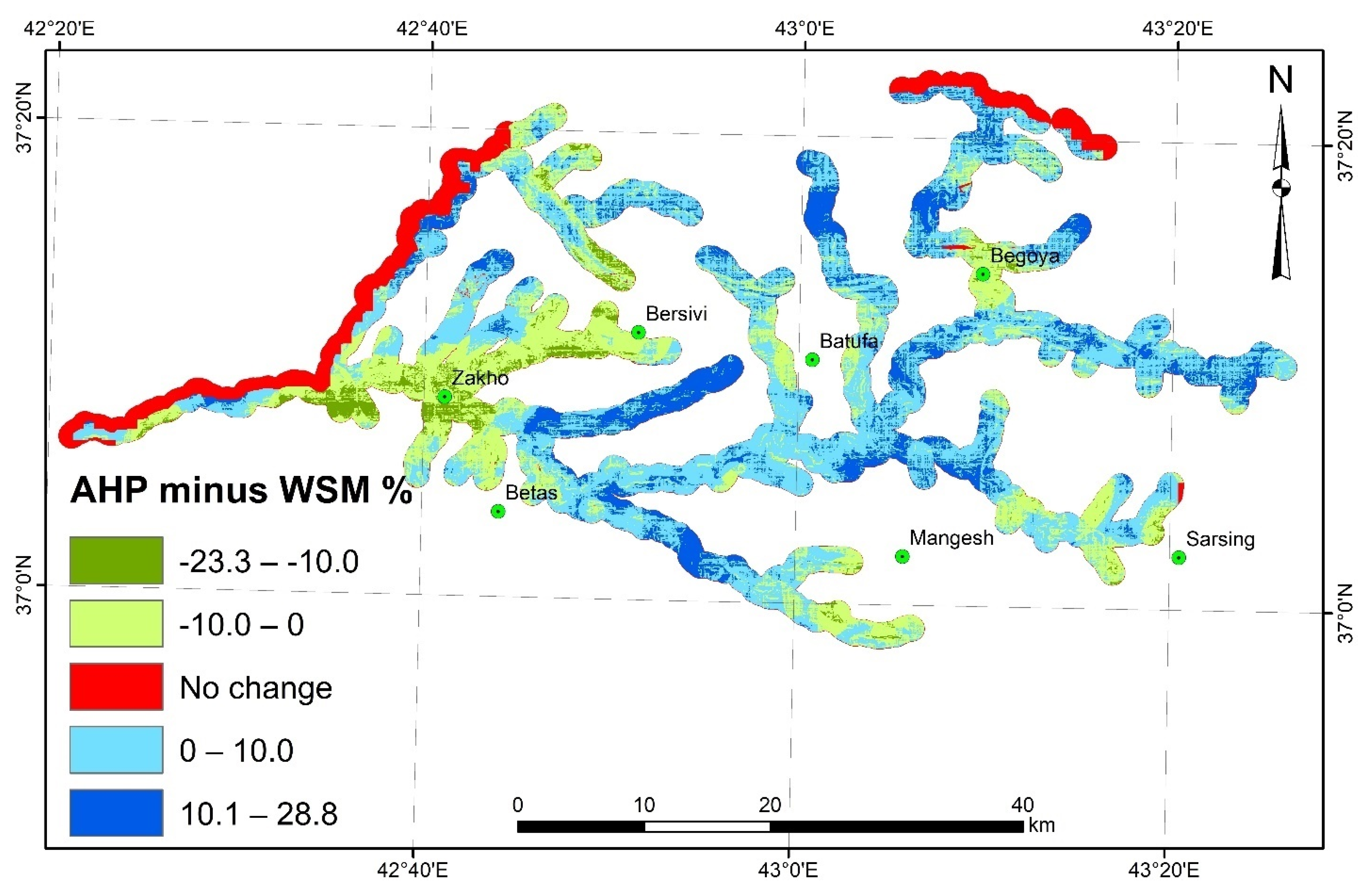
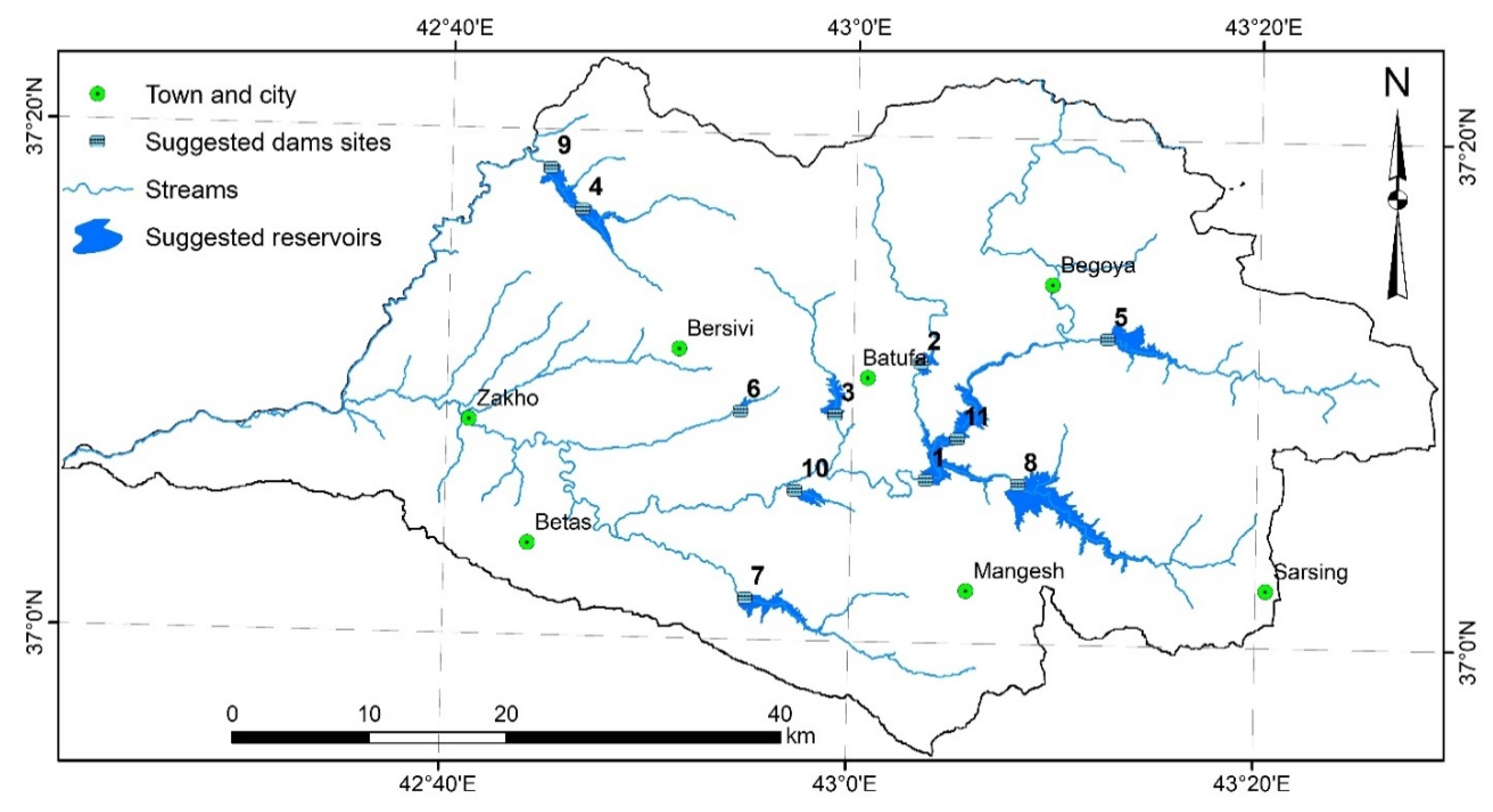
5.1. Identification of Suitable Sites for Dams by the WSM and AHP Models
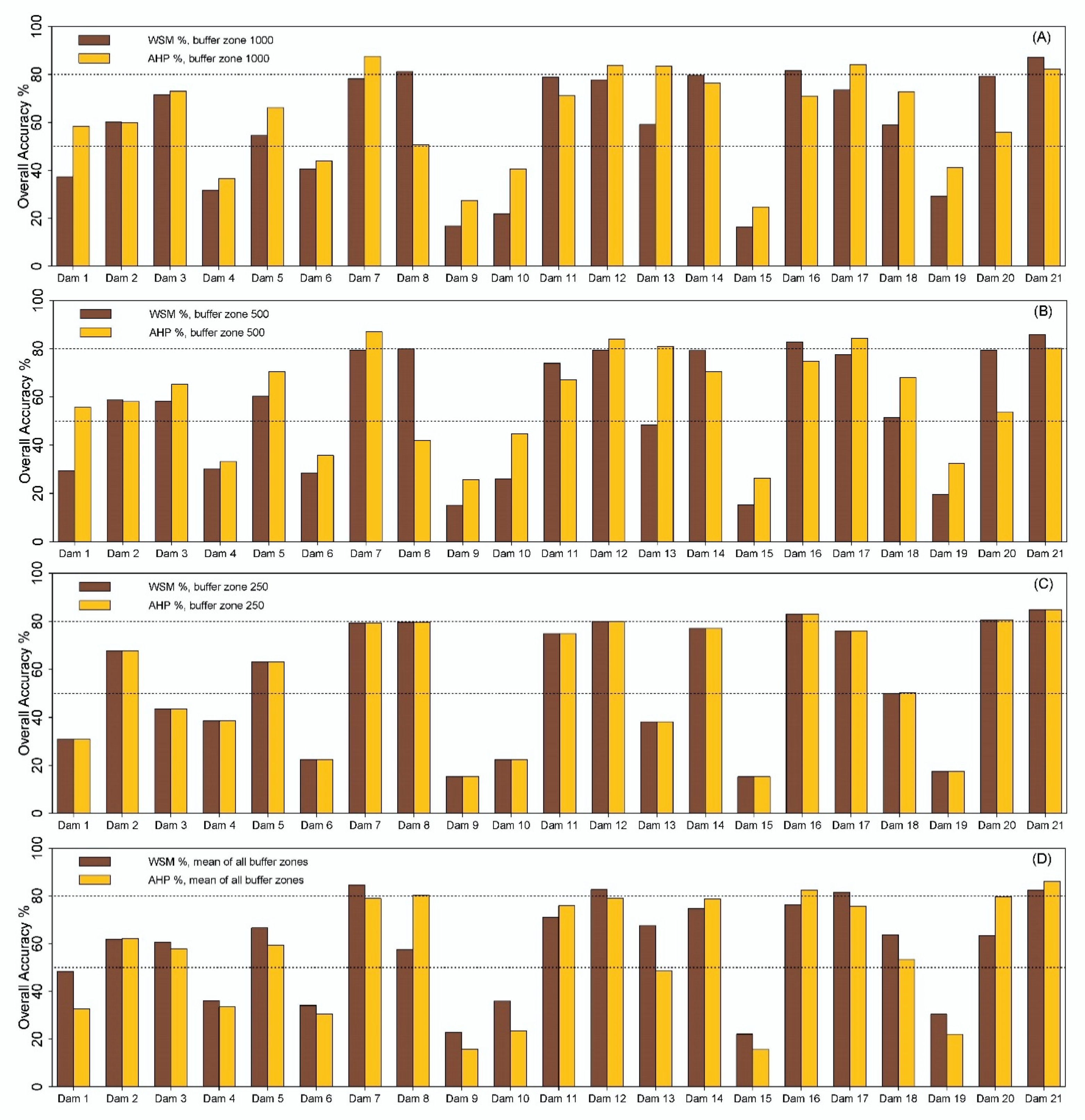
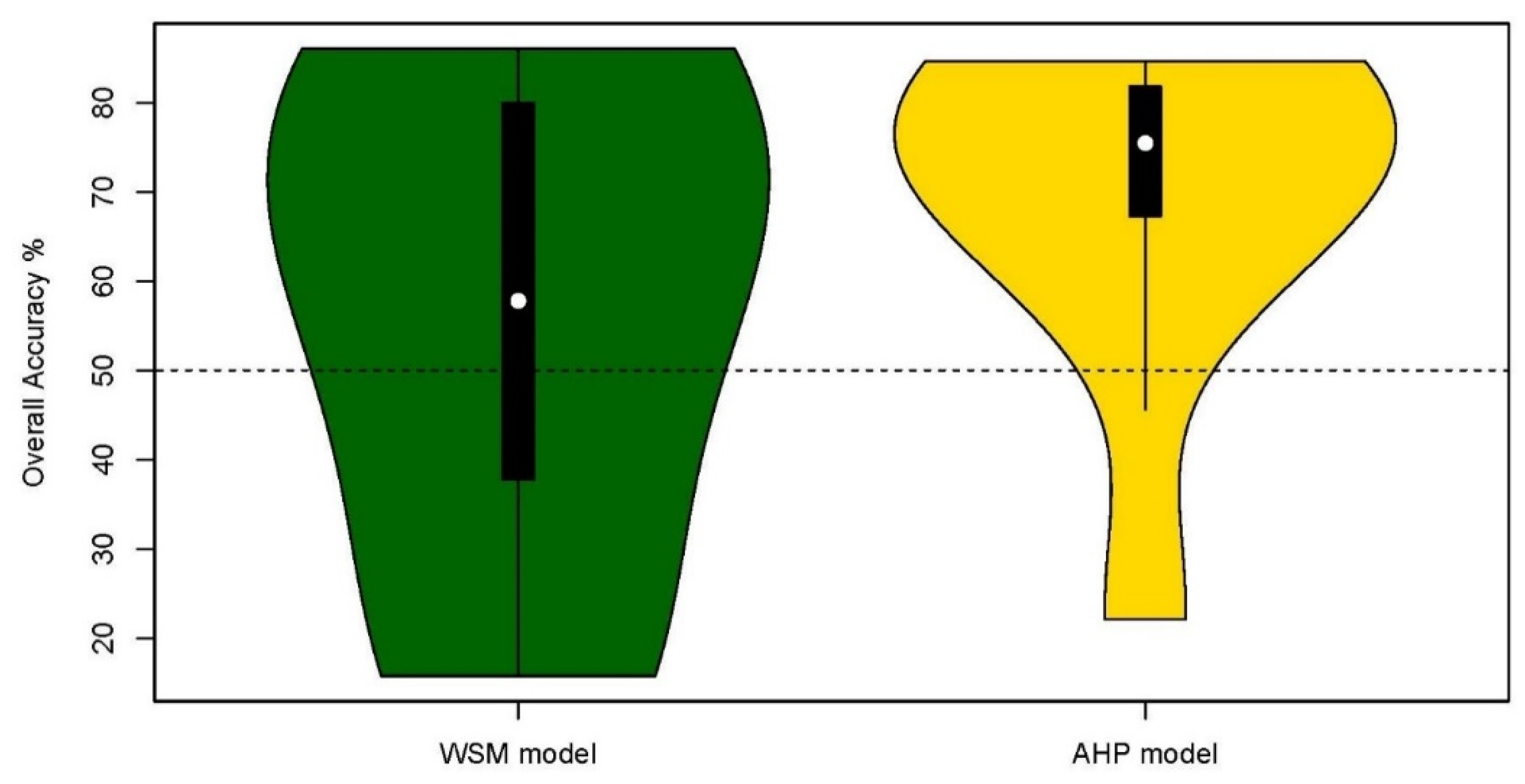
5.2. Classification Accuracy of the Two Adopted Models with Previosly Recommended Sites
6. Discussion
7. Conclusions
Author Contributions
Funding
Acknowledgments
Conflicts of Interest
Appendix A

| No. | Site Name | River order Stream | Latitude | Longitude | Main Purpose | Type of Project | Priority Status | Catchment Area (km2) | Dam Height (m) | Storage Capacity (million m3) |
|---|---|---|---|---|---|---|---|---|---|---|
| 1 | Base | Khabur (1) | 37.1713 | 43.0946 | Irrigation/Energy | Multi-Purpose dam | First | 1962 | 75 | 101 |
| 2 | Sbna2 | Sibna (2) | 37.0589 | 43.2306 | Irrigation/Energy | Agriculture reservoir | First | 138.42 | 38 | 5.95 |
| 3 | Parzoor | Jalal Barzoor (2) | 37.2114 | 42.7036 | Irrigation | Agriculture reservoir | First | 14.6 | 28 | 1.6 |
| 4 | Khizawa | Khabur (1) | 37.2055 | 42.9689 | Irrigation/Energy | Agriculture reservoir | Second | 46.85 | 34 | 2.8 |
| 5 | Zakho | Khabur (1) | 37.072 | 42.8018 | Irrigation/Energy | Agriculture reservoir | Second | 3366.82 | 18 | 17.1 |
| 6 | Barkawar | Khabur (1) | 37.0838 | 42.7894 | Irrigation/Energy | Agriculture reservoir | Second | 3380.93 | 13 | 4.3 |
| 7 | Khuk-sindi | Divro (2) | 37.165 | 42.9384 | Irrigation | Agriculture reservoir | Second | 11.6 | 16 | 1.2 |
| 8 | Bakirman | Unk (2) | 37.1353 | 42.5923 | Irrigation | Agriculture reservoir | Second | 9.12 | 16 | 1 |
| 9 | Kunduk | Shiv a Basagha (4) | 37.2797 | 42.8938 | Irrigation | Agriculture reservoir | Second | 36.95 | 30 | 2 |
| 10 | Suria | Av-a Zariza (2) | 37.2238 | 43.0755 | Irrigation/Energy | Agriculture reservoir | Third | 83 | 22 | 5 |
| 11 | Daldal | Mangesh (3) | 37.0309 | 43.0423 | Irrigation | Agriculture reservoir | Third | 35.6 | 17 | 1.8 |
| 12 | Chiran | Rogarm (2) | 37.0244 | 42.936 | Irrigation/Energy | Agriculture reservoir | Third | 206 | 26 | 9 |
| 13 | Navkandalak | Divro (2) | 37.1399 | 42.8776 | Irrigation/Energy | Agriculture reservoir | Third | 48.4 | 25 | 3 |
| 14 | Darjalal | Shiv-a Jalal (2) | 37.2114 | 42.7514 | Irrigation | Agriculture reservoir | Third | 16.5 | 13 | 0.6 |
| 15 | Begova | Khabur (1) | 37.26 | 43.133 | Irrigation/Energy | Multi-Purpose dam, limited storage | Fourth | 1495 | 85 | 169 |
| 16 | Jamik-Chalki | Khabur (1) | 37.2383 | 43.169 | Energy | Run-of-river hydropower | Fourth | 1584.24 | 48 | 40 |
| 17 | Kovky | Khabur (1) | 37.1075 | 43.061 | Energy | Run-of-river hydropower | Fourth | 2430.3 | 19 | 14 |
| 18 | Bajla | Khabur (1) | 37.0947 | 42.912 | Irrigation/Energy | Run-of-river hydropower | Fourth | 2646.21 | 41 | 104.6 |
| 19 | Khwalish | Khabur (1) | 37.099 | 42.7739 | Energy | Run-of-river hydropower | Fourth | 3406.23 | 24 | 10 |
| 20 | Cham Sermo | Khabur (1) | 37.1317 | 42.703 | Energy | Run-of-river hydropower | Fourth | 3184.59 | 20 | 26.2 |
| 21 | Darkar Ajam | Seasonal stream (3) | 37.2036 | 42.827 | Irrigation | Agriculture reservoir | Existing dam | 4.42 | 15 | 0.15 |
| Reference | Land Cover | Soil | Slope Gradient | Precipitation | Runoff (CN Grid) | Elevation | Lithology | Tectonic Zone | Distance to Active Fault | Distance to the Lineaments | Distance to the Villages | Distance to Road | Distance to the Towns and the Cities | Discharge | Drainage Network Order | Distance from Dam Construction Materials | Total Dissolved Solids TDS | Evaporation | Volume of Depressions | ||
|---|---|---|---|---|---|---|---|---|---|---|---|---|---|---|---|---|---|---|---|---|---|
| Stream width | Gauge station | Drainage density | |||||||||||||||||||
| [14] | * | * | * | * | * | * | * | * | * | * | * | * | |||||||||
| [23] | * | * | * | * | * | * | * | ||||||||||||||
| [24] | * | * | * | * | * | ||||||||||||||||
| [25] | * | * | * | * | * | * | |||||||||||||||
| [26] | * | * | * | * | * | ||||||||||||||||
| [27] | * | * | * | * | |||||||||||||||||
| [28] | * | * | * | * | * | ||||||||||||||||
| [29] | * | * | * | * | * | * | * | * | * | * | |||||||||||
| [30] | * | * | * | * | * | * | * | * | * | * | |||||||||||
| [31] | * | * | * | * | * | * | * | * | * | * | * | ||||||||||
| Rate of use the factor % | 90 | 90 | 80 | 80 | 70 | 40 | 30 | 30 | 30 | 30 | 30 | 20 | 20 | 0 | 10 | 10 | 50 | 10 | 10 | 10 | 10 |
| 20 | |||||||||||||||||||||
| Factor/Subfactor | Suitability | Rank | Factor Weight | Normalized AHP Rank | Normalized SWM Rank | Factor/Sub–Factor | Suitability | Rank | Factor Weight | Normalized AHP Rank | Normalized SWM Rank |
|---|---|---|---|---|---|---|---|---|---|---|---|
| 1. Lithology | Orchard or tree farm | Suitable | 7 | 3 | 1.024 | 1.683 | |||||
| Lake and River | Not suitable | 1 | 9 | 0.439 | 0.240 | Mountain brush mixture of oak brush | Suitable | 7 | 3 | 1.024 | 1.683 |
| Flood Plain | Not suitable | 1 | 9 | 0.439 | 0.240 | Water | Most suitable | 9 | 3 | 1.317 | 2.163 |
| Slope | Not suitable | 1 | 9 | 0.439 | 0.240 | Cultivated land or bare land | Suitable | 7 | 3 | 1.024 | 1.683 |
| Residual Soil | Not suitable | 1 | 9 | 0.439 | 0.240 | 7. Elevation (m) | |||||
| Bai Hassan | Less suitable | 3 | 9 | 1.317 | 0.721 | <500 | Not suitable | 1 | 5 | 0.244 | 0.240 |
| Mukdadiyah | Not suitable | 1 | 9 | 0.439 | 0.240 | 500–600 | Less suitable | 3 | 5 | 0.732 | 0.721 |
| Injana | Moderately suitable | 5 | 9 | 2.195 | 1.202 | 600–700 | Suitable | 7 | 5 | 1.707 | 1.683 |
| Fatha | Not suitable | 1 | 9 | 0.439 | 0.240 | 700–800 | Most suitable | 9 | 5 | 2.195 | 2.163 |
| Pilaspi | Suitable | 7 | 9 | 3.073 | 1.683 | 800–900 | Moderately suitable | 5 | 5 | 1.220 | 1.202 |
| Kolosh | Not suitable | 1 | 9 | 0.439 | 0.240 | 900–1000 | Less suitable | 3 | 5 | 0.732 | 0.721 |
| Shiranish | Less suitable | 3 | 9 | 1.317 | 0.721 | >1000 | Not suitable | 1 | 5 | 0.244 | 0.240 |
| Aqra–Bekhme | Most suitable | 9 | 9 | 3.951 | 2.163 | 8. Slope (°) | |||||
| Mergi | Moderately suitable | 5 | 9 | 2.195 | 1.202 | 0–2 | Most suitable | 9 | 7 | 3.073 | 2.164 |
| Qamchuqa | Suitable | 7 | 9 | 3.073 | 1.683 | 2–10 | Suitable | 7 | 7 | 2.390 | 1.682 |
| Garagu | Suitable | 7 | 9 | 3.073 | 1.683 | 10–20 | Moderately suitable | 5 | 7 | 1.707 | 1.202 |
| Sarmord | Suitable | 7 | 9 | 3.073 | 1.683 | 20–30 | Less suitable | 3 | 7 | 1.024 | 0.721 |
| Chia Gara, Barsarin, Naokelekan, Sargelu | Less suitable | 3 | 9 | 1.317 | 0.721 | >30 | Not suitable | 1 | 7 | 0.342 | 0.240 |
| Sehkaniyan & Sarki | Moderately suitable | 5 | 9 | 2.195 | 1.202 | 9. Precipitation (mm/yr) | |||||
| Kura China & Baluti | Suitable | 7 | 9 | 3.073 | 1.683 | <630 | Not suitable | 1 | 5 | 0.244 | 0.240 |
| Geli Khane | Suitable | 7 | 9 | 3.073 | 1.683 | 630–665 | Less suitable | 3 | 5 | 0.732 | 0.721 |
| Beduh | Not suitable | 1 | 9 | 0.439 | 0.240 | 665–700 | Moderately suitable | 5 | 5 | 1.220 | 1.202 |
| Mirga Mir | Less suitable | 3 | 9 | 1.317 | 0.721 | 700–730 | Suitable | 7 | 5 | 1.707 | 1.683 |
| Chia Zairi | Not suitable | 1 | 9 | 0.439 | 0.240 | >730 | Most suitable | 9 | 5 | 2.195 | 2.164 |
| Harur | Less suitable | 3 | 9 | 1.317 | 0.721 | 10. Stream width (m) | |||||
| Ora | Not suitable | 1 | 9 | 0.439 | 0.240 | <0.6 | Not suitable | 1 | 7 | 0.342 | 0.240 |
| Kaista | Less suitable | 3 | 9 | 1.317 | 0.721 | 0.6–1 | Less suitable | 3 | 7 | 1.024 | 0.721 |
| Khabour | Not suitable | 1 | 9 | 0.439 | 0.240 | 1–2 | Moderately suitable | 5 | 7 | 1.707 | 1.202 |
| 2. Tectonic zones | 2–10 | Suitable | 7 | 7 | 2.390 | 1.683 | |||||
| Imbricated Zone | Less suitable | 3 | 1 | 0.146 | 0.721 | >10 | Most suitable | 9 | 7 | 3.073 | 2.164 |
| High Folded Zone | Moderately suitable | 5 | 1 | 0.244 | 1.202 | 11. Curve Number (CN) | |||||
| 3. Distance to the active fault (m) | >31 | Not suitable | 1 | 5 | 0.244 | 0.240 | |||||
| 0–1000 | Not suitable | 1 | 3 | 0.146 | 0.240 | 31–68 | Less suitable | 3 | 5 | 0.732 | 0.721 |
| 1000–2000 | Less suitable | 3 | 3 | 0.439 | 0.721 | 68–80 | Moderately suitable | 5 | 5 | 1.220 | 1.202 |
| 2000–5000 | Moderately suitable | 5 | 3 | 0.732 | 1.202 | 80–87 | Suitable | 7 | 5 | 1.707 | 1.683 |
| 5000–10,000 | Suitable | 7 | 3 | 1.024 | 1.683 | >87 | Most suitable | 9 | 5 | 2.195 | 2.164 |
| >10,000 | Most suitable | 9 | 3 | 1.317 | 2.163 | 12. Distance to the road (m) | |||||
| 4. Distance to the lineaments (m) | <1000 | Most suitable | 9 | 1 | 0.439 | 2.164 | |||||
| 0–500 | Not suitable | 1 | 3 | 0.146 | 0.240 | 1000–2500 | Suitable | 7 | 1 | 0.342 | 1.683 |
| 500–1000 | Less suitable | 3 | 3 | 0.439 | 0.721 | 2500–5000 | Moderately suitable | 5 | 1 | 0.244 | 1.202 |
| 1000–2000 | Moderately suitable | 5 | 3 | 0.732 | 1.202 | 5000–7500 | Less suitable | 3 | 1 | 0.146 | 0.721 |
| 2000–3000 | Suitable | 7 | 3 | 1.024 | 1.683 | >7500 | Not suitable | 1 | 1 | 0.049 | 0.240 |
| >3000 | Most suitable | 9 | 3 | 1.317 | 2.163 | 13. Distance to the towns and cities (m) | |||||
| 5. Soil type | 250–2500 | Most suitable | 9 | 1 | 0.439 | 2.164 | |||||
| Lithosols and Eutric Cambisols | Not suitable | 1 | 5 | 0.244 | 0.240 | 2500–5000 | Suitable | 7 | 1 | 0.342 | 1.683 |
| Lithosols, Rendzinas, and Calcic Xerosols | Not suitable | 1 | 5 | 0.244 | 0.240 | 5000–10,000 | Moderately suitable | 5 | 1 | 0.244 | 1.202 |
| Lithosols, Calcaric Regoso, and Calcic Xerosols | Not suitable | 1 | 5 | 0.244 | 0.240 | 10,000–12,500 | Less suitable | 3 | 1 | 0.146 | 0.721 |
| Chromic Luvisols, Calcic Cambisols, Lithosols,& Calcaric Regoso | Moderately suitable | 5 | 5 | 1.220 | 1.202 | >12,500 and 0–250 | Not suitable | 1 | 1 | 0.049 | 0.240 |
| Chromic Vertisols, and Calcic Xerosols | Most suitable | 9 | 5 | 2.195 | 2.163 | 14. Distance to the villages (m) | |||||
| Calcic Xerosols, Rendzinas, and Chromic Vertisols | Less suitable | 3 | 5 | 0.732 | 0.721 | 250–1000 | Most suitable | 9 | 1 | 0.439 | 2.164 |
| 6. Land cover | 1000–1500 | Suitable | 7 | 1 | 0.342 | 1.683 | |||||
| Built–up | Not suitable | 1 | 3 | 0.146 | 0.240 | 1500–2000 | Moderately suitable | 5 | 1 | 0.244 | 1.202 |
| Bare land | Suitable | 7 | 3 | 1.024 | 1.683 | 2000–3000 | Less suitable | 3 | 1 | 0.146 | 0.721 |
| Road | Not suitable | 1 | 3 | 0.146 | 0.240 | >3000 and 0–250 | Not suitable | 1 | 1 | 0.049 | 0.240 |
| Dam Number | 1 | 2 | 3 | 4 | 5 | 6 | 7 | 8 | 9 | 10 | 11 | 12 | 13 | 14 | 15 | 16 | 17 | 18 | 19 | 20 | 21 | |
|---|---|---|---|---|---|---|---|---|---|---|---|---|---|---|---|---|---|---|---|---|---|---|
| Buffer 1000 m | Np | 3492 | 3501 | 3485 | 3496 | 3500 | 3483 | 3489 | 3493 | 3493 | 3491 | 3486 | 3503 | 3490 | 3500 | 3487 | 3493 | 3489 | 3484 | 3495 | 3486 | 3501 |
| Sp (WSM) | 1075 | 2361 | 3056 | 754 | 2072 | 1205 | 3396 | 3493 | 40 | 181 | 3300 | 3385 | 2238 | 3450 | 133 | 3452 | 3076 | 2291 | 565 | 3385 | 3501 | |
| Sp (AHP) | 2178 | 2338 | 3092 | 1059 | 2682 | 1369 | 3489 | 1820 | 579 | 1257 | 2852 | 3476 | 3468 | 3246 | 431 | 2897 | 3480 | 3072 | 1240 | 2106 | 3446 | |
| As (WSM) | 30.78 | 67.44 | 87.69 | 21.57 | 59.20 | 34.60 | 97.33 | 100.00 | 1.15 | 5.18 | 94.66 | 96.63 | 64.13 | 98.57 | 3.81 | 98.83 | 88.16 | 65.76 | 16.17 | 97.10 | 100.00 | |
| As (AHP) | 62.37 | 66.78 | 88.72 | 30.29 | 76.63 | 39.31 | 100.00 | 52.10 | 16.58 | 36.01 | 81.81 | 99.23 | 99.37 | 92.74 | 12.36 | 82.94 | 99.74 | 88.17 | 35.48 | 60.41 | 98.43 | |
| Aw (WSM) | 54.43 | 53.06 | 57.22 | 42.94 | 55.72 | 48.52 | 75.23 | 49.22 | 38.21 | 45.02 | 60.42 | 68.48 | 67.49 | 59.96 | 37.07 | 59.11 | 68.40 | 57.45 | 46.82 | 51.26 | 66.02 | |
| Aw (AHP) | 43.87 | 52.78 | 55.41 | 41.90 | 49.92 | 46.55 | 59.07 | 62.39 | 32.49 | 38.59 | 63.14 | 58.92 | 54.10 | 60.81 | 28.86 | 64.42 | 58.91 | 51.95 | 42.22 | 61.56 | 74.42 | |
| OA (WSM) | 37.33 | 60.11 | 71.55 | 31.73 | 54.56 | 40.57 | 78.20 | 81.19 | 16.82 | 21.89 | 78.90 | 77.78 | 59.11 | 79.69 | 16.34 | 81.62 | 73.54 | 58.85 | 29.19 | 79.33 | 87.21 | |
| OA (AHP) | 58.40 | 59.92 | 72.97 | 36.62 | 66.18 | 43.91 | 87.61 | 50.66 | 27.39 | 40.51 | 71.12 | 83.85 | 83.43 | 76.35 | 24.71 | 71.02 | 84.07 | 72.81 | 41.15 | 55.84 | 82.22 | |
| Buffer 500 m | NP | 872 | 873 | 875 | 870 | 875 | 873 | 871 | 871 | 870 | 874 | 876 | 875 | 871 | 874 | 873 | 873 | 874 | 875 | 873 | 874 | 871 |
| Sp (WSM) | 141 | 568 | 570 | 155 | 601 | 115 | 870 | 871 | 0 | 105 | 754 | 873 | 404 | 858 | 13 | 870 | 835 | 462 | 14 | 853 | 871 | |
| Sp (AHP) | 511 | 551 | 663 | 211 | 731 | 227 | 871 | 332 | 134 | 373 | 666 | 875 | 858 | 723 | 125 | 775 | 871 | 714 | 192 | 500 | 852 | |
| As (WSM) | 16.17 | 65.06 | 65.14 | 17.82 | 68.69 | 13.17 | 99.89 | 100.00 | 0.00 | 12.01 | 86.07 | 99.77 | 46.38 | 98.17 | 1.49 | 99.66 | 95.54 | 52.80 | 1.60 | 97.60 | 100.00 | |
| As (AHP) | 58.60 | 63.12 | 75.77 | 24.25 | 83.54 | 26.00 | 100.00 | 38.12 | 15.40 | 42.68 | 76.03 | 100.00 | 98.51 | 82.72 | 14.32 | 88.77 | 99.66 | 81.60 | 21.99 | 57.21 | 97.82 | |
| Aw (WSM) | 52.62 | 53.00 | 54.60 | 42.11 | 57.33 | 45.48 | 73.95 | 45.92 | 36.05 | 46.72 | 58.20 | 68.01 | 63.45 | 58.02 | 38.18 | 60.80 | 68.96 | 54.48 | 43.01 | 50.29 | 62.44 | |
| Aw (AHP) | 42.61 | 52.24 | 51.39 | 42.52 | 51.81 | 43.46 | 58.88 | 59.79 | 30.25 | 40.00 | 61.85 | 59.11 | 50.32 | 60.35 | 29.14 | 65.70 | 59.62 | 50.00 | 37.48 | 61.03 | 71.84 | |
| OA (WSM) | 29.39 | 58.65 | 58.27 | 30.17 | 60.25 | 28.32 | 79.38 | 79.90 | 15.12 | 26.01 | 73.96 | 79.44 | 48.35 | 79.26 | 15.31 | 82.68 | 77.58 | 51.40 | 19.54 | 79.31 | 85.92 | |
| OA (AHP) | 55.61 | 58.06 | 65.19 | 33.18 | 70.43 | 35.74 | 86.97 | 42.02 | 25.72 | 44.70 | 67.11 | 84.00 | 80.98 | 70.37 | 26.25 | 74.79 | 84.31 | 68.04 | 32.50 | 53.75 | 80.13 | |
| Buffer 250 m | NP | 220 | 217 | 219 | 219 | 214 | 220 | 217 | 216 | 219 | 219 | 221 | 216 | 214 | 217 | 219 | 216 | 219 | 218 | 219 | 220 | 217 |
| Sp (WSM) | 41 | 177 | 86 | 67 | 157 | 7 | 217 | 216 | 0 | 14 | 201 | 216 | 60 | 209 | 0 | 216 | 202 | 110 | 0 | 219 | 217 | |
| Sp (AHP) | 41 | 177 | 86 | 67 | 157 | 7 | 217 | 216 | 0 | 14 | 201 | 216 | 60 | 209 | 0 | 216 | 202 | 110 | 0 | 219 | 217 | |
| As (WSM) | 18.64 | 81.57 | 39.27 | 30.59 | 73.36 | 3.18 | 100.00 | 100.00 | 0.00 | 6.39 | 90.95 | 100.00 | 28.04 | 96.31 | 0.00 | 100.00 | 92.24 | 50.46 | 0.00 | 99.55 | 100.00 | |
| As (AHP) | 18.64 | 81.57 | 39.27 | 30.59 | 73.36 | 3.18 | 100.00 | 100.00 | 0.00 | 6.39 | 90.95 | 100.00 | 28.04 | 96.31 | 0.00 | 100.00 | 92.24 | 50.46 | 0.00 | 99.55 | 100.00 | |
| Aw (WSM) | 43.13 | 53.81 | 47.68 | 46.52 | 52.94 | 41.84 | 58.60 | 59.45 | 30.63 | 38.38 | 58.80 | 59.99 | 48.29 | 57.90 | 30.48 | 66.07 | 59.96 | 49.33 | 34.90 | 61.40 | 69.90 | |
| Aw (AHP) | 43.13 | 53.81 | 47.68 | 46.52 | 52.94 | 41.84 | 58.60 | 59.45 | 30.63 | 38.38 | 58.80 | 59.99 | 48.29 | 57.90 | 30.48 | 66.07 | 59.96 | 50.03 | 34.90 | 61.40 | 69.90 | |
| OA (WSM) | 30.88 | 67.69 | 43.48 | 38.56 | 63.15 | 22.51 | 79.30 | 79.72 | 15.31 | 22.39 | 74.87 | 79.99 | 38.16 | 77.11 | 15.24 | 83.03 | 76.10 | 49.89 | 17.45 | 80.47 | 84.95 | |
| OA (AHP) | 30.88 | 67.69 | 43.48 | 38.56 | 63.15 | 22.51 | 79.30 | 79.72 | 15.31 | 22.39 | 74.87 | 79.99 | 38.16 | 77.11 | 15.24 | 83.03 | 76.10 | 50.25 | 17.45 | 80.47 | 84.95 | |
| Mean of all buffer zones | OA (AHP) | 48.30 | 61.89 | 60.55 | 36.12 | 66.59 | 34.05 | 84.63 | 57.47 | 22.81 | 35.87 | 71.04 | 82.62 | 67.52 | 74.61 | 22.07 | 76.28 | 81.49 | 63.70 | 30.37 | 63.35 | 82.43 |
| OA (WSM) | 32.53 | 62.15 | 57.77 | 33.49 | 59.32 | 30.47 | 78.96 | 80.27 | 15.75 | 23.43 | 75.91 | 79.07 | 48.54 | 78.69 | 15.63 | 82.44 | 75.74 | 53.38 | 22.06 | 79.70 | 86.03 |


References
- UN. World Population Prospects the 2017 Revision; UN: New York, NY, USA, 2017. [Google Scholar]
- UN United Nations Decade for Deserts and the Fight against Desertification. Available online: http://www.un.org/en/events/desertification_decade/whynow.shtml (accessed on 27 February 2020).
- Jassim, M.D. The Reality and Future of Water Resources in Iraq 2010; Ministry of Water Resources: Baghdad, Iraq, 2010.
- UNDP. Drought Impact Assessment, Recovery and Mitigation Framework and Regional Project Design in Kurdistan Region (KR); UNDP: New York, NY, USA, 2011. [Google Scholar]
- Fard, F.V.; Khosravi, M.; Talebi, M.; Jafarzadeh, F. Evaluating liquefaction potential in an embankment dam foundation using shear wave velocity measurements. In Proceedings of the Annual Conference—Canadian Society for Civil Engineering, Yellowknife, NT, Canada, 6–9 June 2007; Volume 1, pp. 362–369. [Google Scholar]
- Gholami, R.; Rasouli, V. Mechanical and elastic properties of transversely isotropic slate. Rock Mech. Rock Eng. 2014, 47, 1763–1773. [Google Scholar] [CrossRef]
- Issa, I.E. Sedimentological and Hydrological Investigation of Mosul Dam Reservoir. Ph.D. Thesis, Luleå University of Technology, Luleå, Sweden, 2015. [Google Scholar]
- Ibrahim, G.R.F.; Rasul, A.; Hamid, A.A.; Ali, Z.F.; Dewana, A.A. Suitable site selection for rainwater harvesting and storage case study using Dohuk governorate. Water 2019, 11, 864. [Google Scholar] [CrossRef]
- Mugo, G.M.; Odera, P.A. Site selection for rainwater harvesting structures in Kiambu County-Kenya. Egypt. J. Remote Sens. Space Sci. 2019, 22, 155–164. [Google Scholar] [CrossRef]
- Akintorinwa, O.J.; Okoro, O.V. Combine electrical resistivity method and multi-criteria GIS-based modeling for landfill site selection in the Southwestern Nigeria. Environ. Earth Sci. 2019, 78, 162. [Google Scholar] [CrossRef]
- Saaty, T.L.; Vargas, L.G. Hierarchical analysis of behavior in competition: Prediction in chess. Behav. Sci. 1980, 25, 180–191. [Google Scholar] [CrossRef]
- Fishburn, P.C. Additive Utilities with Incomplete Product Set: Applications to Priorities and Assignments. Oper. Res. 1967, 15, 537–542. [Google Scholar] [CrossRef]
- Nzotcha, U.; Kenfack, J.; Blanche Manjia, M. Integrated multi-criteria decision making methodology for pumped hydro-energy storage plant site selection from a sustainable development perspective with an application. Renew. Sustain. Energy Rev. 2019, 112, 930–947. [Google Scholar] [CrossRef]
- Noori, A.M.; Pradhan, B.; Ajaj, Q.M. Dam site suitability assessment at the Greater Zab River in northern Iraq using remote sensing data and GIS. J. Hydrol. 2019, 574, 964–979. [Google Scholar] [CrossRef]
- Naraghi, S.; Masoumi, I.; Rashidinejad, F. Optimization of tailings disposal method using fuzzy analytic hierarchy process. Water Sci. Technol. Water Supply 2019, 19, 1563–1571. [Google Scholar] [CrossRef]
- Ministry of Agricultural and Water Resources (MAWR). Dams Master Plan for Kurdistan; Ministry of Agricultural and Water Resources (MAWR): Erbil, Iraq, 2013.
- Othman, A.A.; Al- Maamar, A.F.; Al-Manmi, D.A.M.; Liesenberg, V.; Hasan, S.; Al-Saady, Y.I.; Shihab, A.T.; Khwedim, K. Application of DInSAR-PSI Technology for Deformation Monitoring of the Mosul Dam, Iraq. Remote Sens. 2019, 11, 2632. [Google Scholar] [CrossRef]
- Milillo, P.; Bürgmann, R.; Lundgren, P.; Salzer, J.; Perissin, D.; Fielding, E.; Biondi, F.; Milillo, G. Space geodetic monitoring of engineered structures: The ongoing destabilization of the Mosul dam, Iraq. Sci. Rep. 2016, 6, 37408. [Google Scholar] [CrossRef] [PubMed]
- Jha, M.K.; Chowdary, V.M.; Kulkarni, Y.; Mal, B.C. Rainwater harvesting planning using geospatial techniques and multicriteria decision analysis. Resour. Conserv. Recycl. 2014, 83, 96–111. [Google Scholar] [CrossRef]
- CityPopulation Iraq: Governorates, Major Cities & Urban Centers—Population Statistics, Maps, Charts, Weather and Web Information. Available online: http://www.citypopulation.de/Iraq-Cities.html (accessed on 27 February 2020).
- Fell, R.; MacGregor, P.; Stapledon, D.; Bell, G. Geotechnical Engineering of Dams; CRC Press: Boca Raton, FL, USA, 2005; ISBN 9780415889322. [Google Scholar]
- Climate Data; The Agro-Meteorological Department of the General Directorate of Research and Agricultural Extension of the Ministry of Agriculture of the Kurdistan Regional, Kurdistan-Iraq, The Agro-Meteorological Department of the General Directorate of Research and Agricultural Extension of the Ministry of Agriculture of the Kurdistan Regional, Iraq: Kurdistan, Iraq, 2006.
- Ramakrishnan, D.; Bandyopadhyay, A.; Kusuma, K.N. SCS-CN and GIS-based approach for identifying potential water harvesting sites in the Kali Watershed, Mahi River Basin, India. J. Earth Syst. Sci. 2009, 118, 355–368. [Google Scholar] [CrossRef]
- Grum, B.; Hessel, R.; Kessler, A.; Woldearegay, K.; Yazew, E.; Ritsema, C.; Geissen, V. A decision support approach for the selection and implementation of water harvesting techniques in arid and semi-arid regions. Agric. Water Manag. 2016, 173, 35–47. [Google Scholar] [CrossRef]
- Tiwari, K.; Goyal, R.; Sarkar, A. GIS-based Methodology for Identification of Suitable Locations for Rainwater Harvesting Structures. Water Resour. Manag. 2018, 32, 1811–1825. [Google Scholar] [CrossRef]
- Al-Abadi, A.M.; Shahid, S.; Ghalib, H.B.; Handhal, A.M. A GIS-Based Integrated Fuzzy Logic and Analytic Hierarchy Process Model for Assessing Water-Harvesting Zones in Northeastern Maysan Governorate, Iraq. Arab. J. Sci. Eng. 2017, 42, 2487–2499. [Google Scholar] [CrossRef]
- Rejani, R.; Rao, K.V.; Rao, C.H.S.; Osman, M.; Reddy, K.S.; George, B. Identification Of Potential Rainwater-Harvesting Sites For The Sustainable Management Of A Semi-Arid Watershed. Irrig. Drain. 2017, 66, 227–237. [Google Scholar] [CrossRef]
- Mahmoud, S.H.; Tang, X. Monitoring prospective sites for rainwater harvesting and stormwater management in the United Kingdom using a GIS-based decision support system. Environ. Earth Sci. 2015, 73, 8621–8638. [Google Scholar] [CrossRef]
- Sayl, K.N.; Muhammad, N.S.; El-Shafie, A. Robust approach for optimal positioning and ranking potential rainwater harvesting structure (RWH): A case study of Iraq. Arab. J. Geosci. 2017, 10, 413. [Google Scholar] [CrossRef]
- Singhai, A.; Das, S.; Kadam, A.K.; Shukla, J.P.; Bundela, D.S.; Kalashetty, M. GIS-based multi-criteria approach for identification of rainwater harvesting zones in upper Betwa sub-basin of Madhya Pradesh, India. Environ. Dev. Sustain. 2019, 21, 777–797. [Google Scholar] [CrossRef]
- Al-Ruzouq, R.; Shanableh, A.; Yilmaz, A.G.; Idris, A.; Mukherjee, S.; Khalil, M.A.; Gibril, M.B. Dam Site Suitability Mapping and Analysis Using an Integrated GIS and Machine Learning Approach. Water 2019, 11, 1880. [Google Scholar] [CrossRef]
- Jenks, G.F. The Data Model Concept in Statistical Mapping. Int. Yearb. Cartogr. 1967, 7, 186–190. [Google Scholar]
- Othman, A.A.; Gloaguen, R.; Andreani, L.; Rahnama, M. Improving landslide susceptibility mapping using morphometric features in the Mawat area, Kurdistan Region, NE Iraq: Comparison of different statistical models. Geomorphology 2018, 319, 147–160. [Google Scholar] [CrossRef]
- Mulliner, E.; Malys, N.; Maliene, V. Comparative analysis of MCDM methods for the assessment of sustainable housing affordability. Omega (United Kingdom) 2016, 59, 146–156. [Google Scholar] [CrossRef]
- Guitouni, A.; Martel, J.-M. Tentative guidelines to help choosing an appropriate MCDA method. Eur. J. Oper. Res. 1998, 109, 501–521. [Google Scholar] [CrossRef]
- Roy, B.; Słowiński, R. Questions guiding the choice of a multicriteria decision aiding method. EURO J. Decis. Process. 2013, 1, 69–97. [Google Scholar] [CrossRef]
- Triantaphyllou, E. Multi-criteria Decision Making Methods: A Comparative Study; Applied Optimization; Springer: New York, NY, USA, 2000; ISBN 9780792366072. [Google Scholar]
- Hwang, C.L.; Yoon, K. Multiple Attribute Decision Making: Methods and Applications A State-of-the-Art Survey; Lecture Notes in Economics and Mathematical Systems; Springer: Berlin/Heidelberg, Germany, 2012; ISBN 9783642483189. [Google Scholar]
- Miller, D.W.; Starr, M.K. Executive Decisions and Operations Research; Prentice-Hall international series in management; Prentice-Hall: Upper Saddle River, NJ, USA, 1969. [Google Scholar]
- Damasceno Pavani, I.; Ennes Cicerelli, R.; de Almeida, T.; Zandonadi Moura, L.; Contreras, F. Allocation of sanitary landfill in consortium: Strategy for the Brazilian municipalities in the State of Amazonas. Environ. Monit. Assess. 2019, 191. [Google Scholar] [CrossRef]
- Ekmekçioĝlu, M.; Kaya, T.; Kahraman, C. Fuzzy multicriteria disposal method and site selection for municipal solid waste. Waste Manag. 2010, 30, 1729–1736. [Google Scholar] [CrossRef]
- Coban, A.; Ertis, I.F.; Cavdaroglu, N.A. Municipal solid waste management via multi-criteria decision making methods: A case study in Istanbul, Turkey. J. Clean. Prod. 2018, 180, 159–167. [Google Scholar] [CrossRef]
- Bah, Y.; Tsiko, R.G. Landfill site selection by integrating geographical information systems and multi-criteria decision analysis: A case study of Freetown, Sierra Leone. African Geogr. Rev. 2011, 30, 67–99. [Google Scholar] [CrossRef]
- Shahabi, H.; Keihanfard, S.; Ahmad, B.B.; Amiri, M.J.T. Evaluating Boolean, AHP and WLC methods for the selection of waste landfill sites using GIS and satellite images. Environ. Earth Sci. 2014, 71, 4221–4233. [Google Scholar] [CrossRef]
- Cheng, S.; Chan, C.W.; Huang, G.H. Using multiple criteria decision analysis for supporting decisions of solid waste management. J. Environ. Sci. Heal. - Part A Toxic/Hazardous Subst. Environ. Eng. 2002, 37, 975–990. [Google Scholar] [CrossRef] [PubMed]
- Bellehumeur, C.; Vasseur, L.; Ansseau, C.; Marcos, B. Implementation of a multicriteria sewage sludge management model in the southern Quebec municipality of Lac-Megantic, Canada. J. Environ. Manage. 1997, 50, 51–66. [Google Scholar] [CrossRef]
- Saaty, T.L. The Analytic Hierarchy Process in Conflict Management. Int. J. Confl. Manag. 1990, 1, 47–68. [Google Scholar] [CrossRef]
- Zhang, L.; Lavagnolo, M.C.; Bai, H.; Pivato, A.; Raga, R.; Yue, D. Environmental and economic assessment of leachate concentrate treatment technologies using analytic hierarchy process. Resour. Conserv. Recycl. 2019, 474–480. [Google Scholar] [CrossRef]
- Salar, S.G.; Othman, A.A.; Hasan, S.E. Identification of suitable sites for groundwater recharge in Awaspi watershed using GIS and remote sensing techniques. Environ. Earth Sci. 2018, 77. [Google Scholar] [CrossRef]
- Clinton, N.; Holt, A.; Scarborough, J.; Yan, L.I.; Gong, P. Accuracy assessment measures for object-based image segmentation goodness. Photogramm. Eng. Remote Sens. 2010, 76, 289–299. [Google Scholar] [CrossRef]
- Ayalew, L.; Yamagishi, H. The application of GIS-based logistic regression for landslide susceptibility mapping in the Kakuda-Yahiko Mountains, Central Japan. Geomorphology 2005, 65, 15–31. [Google Scholar] [CrossRef]
- Sissakian, V.K. Geological Report on Al-Mosul Quadrangle, Sheet No. NJ–38–03, Scale 1:250 000; Iraq Geological Survey: Baghdad, Iraq, 1995.
- Al-Mousawi, H.A.; Sissakian, V.K.; Fouad, S.F.; Survey, I.G. The Geology of ZakhoQuadrangle, Scale 1:250000; Iraq Geological Survey: Baghdad, Iraq, 2008.
- Foad, S. Tectonic Map of Iraq, Scale 1:1,000,000; Iraq Geological Survey: Baghdad, Iraq, 2012.
- Alavi, M. Structures of the Zagros fold-thrust belt in Iran. Am. J. Sci. 2007, 307, 1064–1095. [Google Scholar] [CrossRef]
- Obaid, A.K.; Allen, M.B. Landscape maturity, fold growth sequence and structural style in the Kirkuk Embayment of the Zagros, northern Iraq. Tectonophysics 2017, 717, 27–40. [Google Scholar] [CrossRef]
- Obaid, A.K.; Allen, M.B. Landscape expressions of tectonics in the Zagros fold-and-thrust belt. Tectonophysics 2019, 766, 20–30. [Google Scholar] [CrossRef]
- Othman, A.A.; Gloaguen, R. River Courses Affected by Landslides and Implications for Hazard Assessment: A High Resolution Remote Sensing Case Study in NE Iraq–W Iran. Remote Sens. 2013, 5, 1024–1044. [Google Scholar] [CrossRef]
- Othman, A.A.; Gloaguen, R. Automatic extraction and size distribution of landslides in kurdistan region, NE Iraq. Remote Sens. 2013, 5, 2389–2410. [Google Scholar] [CrossRef]
- De Vera, J.; Gines, J. Structure of the Zagros fold and thrust belt in the Kurdistan Region, northern Iraq. Trabajos de Geología 2009, 217, 213–217. [Google Scholar]
- Forzieri, G.; Gardenti, M.; Caparrini, F.; Castelli, F. A methodology for the pre-selection of suitable sites for surface and underground small dams in arid areas: A case study in the region of Kidal, Mali. Phys. Chem. Earth Parts A/B/C 2008, 33, 74–85. [Google Scholar] [CrossRef]
- Javhar, A.; Chen, X.; Bao, A.; Jamshed, A.; Yunus, M.; Jovid, A.; Latipa, T. Comparison of multi-resolution optical Landsat-8, Sentinel-2 and radar Sentinel-1 data for automatic lineament extraction: A case study of Alichur area, SE Pamir. Remote Sens. 2019, 11. [Google Scholar] [CrossRef]
- ESRI. ArcGIS Desktop: Release 10 2011. Available online: https://desktop.arcgis.com/en/ (accessed on 27 February 2020).
- EROS Landsat OLI. Available online: https://earthexplorer.usgs.gov/ (accessed on 27 February 2020).
- Geomatica, P. PCI Geomatica 2016. Available online: https://www.pcigeomatics.com/ (accessed on 27 February 2020).
- Nachtergaele, F.; van Velthuizen, H.; van Engelen, V.; Fischer, G.; Jones, A.; Montanarella, L.; Petri, M.; Prieler, S.; Teixeira, E.; Shi, X. Harmonized World Soil Database (Version 1.2); ORNL DAAC: Oak Ridge, TN, USA, 2012; pp. 1–50. Available online: http://daac.ornl.gov/cgi-bin/dsviewer.pl?ds_id=1247 (accessed on 27 February 2020).
- Adham, A.; Riksen, M.; Ouessar, M.; Abed, R.; Ritsema, C. Development of Methodology for Existing Rainwater Harvesting Assessment in (semi-)Arid Regions BT. In Water and Land Security in Drylands: Response to Climate Change; Ouessar, M., Gabriels, D., Tsunekawa, A., Evett, S., Eds.; Springer International Publishing: Cham, Switzerland, 2017; pp. 171–184. ISBN 978-3-319-54021-4. [Google Scholar]
- Kahinda, J.M.; Lillie, E.S.B.; Taigbenu, A.E.; Taute, M.; Boroto, R.J. Developing suitability maps for rainwater harvesting in South Africa. Phys. Chem. Earth Parts A/B/C 2008, 33, 788–799. [Google Scholar] [CrossRef]
- Mbilinyi, B.P.; Tumbo, S.D.; Mahoo, H.F.; Mkiramwinyi, F.O. GIS-based decision support system for identifying potential sites for rainwater harvesting. Phys. Chem. Earth Parts A/B/C 2007, 32, 1074–1081. [Google Scholar] [CrossRef]
- USDA. Soil Mechanics Level 1, Module 3. USDA Textural Classification Study Guide; USDA: Washington, DC, USA, 1987.
- Vapnik, V.N. The Nature of Statistical Learning Theory, 2nd ed.; Springer: New York, NY, USA, 1999. [Google Scholar]
- Othman, A.A.; Gloaguen, R. Improving lithological mapping by SVM classification of spectral and morphological features: The discovery of a new chromite body in the Mawat ophiolite complex (Kurdistan, NE Iraq). Remote Sens. 2014, 6, 6867–6896. [Google Scholar] [CrossRef]
- Yang, X. Parameterizing support vector machines for land cover classification. Photogramm. Eng. Remote Sens. 2011, 77, 27–38. [Google Scholar] [CrossRef]
- Othman, A.; Al-Saady, Y.; Al-Khafaji, A.; Gloaguen, R. Environmental change detection in the central part of Iraq using remote sensing data and GIS. Arab. J. Geosci. 2014, 7, 1017–1028. [Google Scholar] [CrossRef]
- Congalton, R.G. A review of assessing the accuracy of classifications of remotely sensed data. Remote Sens. Environ. 1991, 37, 35–46. [Google Scholar] [CrossRef]
- Cohen, J. A coefficient of agreement of nominal scales. Psychol. Meas. 1960, 2, 37–46. [Google Scholar] [CrossRef]
- Charnpratheep, K.; Zhou, Q.; Garner, B. Preliminary landfill site screening using fuzzy geographical information systems. Waste Manag. Res. 1997, 15, 197–215. [Google Scholar] [CrossRef]
- Demesouka, O.E.; Vavatsikos, A.P.; Anagnostopoulos, K.P. GIS-based multicriteria municipal solid waste landfill suitability analysis: A review of the methodologies performed and criteria implemented. Waste Manag. Res. 2014, 32, 270–296. [Google Scholar] [CrossRef]
- Buraihi, F.H.; Shariff, A.R.M. Selection of rainwater harvesting sites by using remote sensing and GIS techniques: A case study of Kirkuk, Iraq. J. Teknol. 2015, 76, 75–81. [Google Scholar] [CrossRef]
- Hamzeh, M.; Ali Abbaspour, R.; Davalou, R. Raster-based outranking method: A new approach for municipal solid waste landfill (MSW) siting. Environ. Sci. Pollut. Res. 2015, 22, 12511–12524. [Google Scholar] [CrossRef]
- GSFC_DAAC Tropical Rainfall Measurement Mission Project (TRMM;3B43 V7). Available online: http://disc.gsfc.nasa.gov/datacollection/TRMM_3B42_daily_V6.shtml (accessed on 27 February 2020).
- Kummerow, C.; Barnes, W.; Kozu, T.; Shiue, J.; Simpson, J. The Tropical Rainfall Measuring Mission (TRMM) sensor package. J. Atmos. Ocean. Technol. 1998, 15, 809–817. [Google Scholar] [CrossRef]
- Yousuf, M.A.; Rapantova, N.; Younis, J.H. Sustainable water management in Iraq (Kurdistan) as a challenge for governmental responsibility. Water 2018, 10, 1651. [Google Scholar] [CrossRef]
- Deus, D.; Gloaguen, R. Remote Sensing Analysis of Lake Dynamics in Semi-Arid Regions: Implication for Water Resource Management. Lake Manyara, East African Rift, Northern Tanzania. Water 2013, 5, 698–727. [Google Scholar] [CrossRef]
- Andreani, L.; Gloaguen, R.; Shahzad, F. A new set of MATLAB functions (TecDEM toolbox) to analyze erosional stages in landscapes and base-level changes in river profiles. Geophys. Res. Abstr. 2014, 16. Available online: https://ui.adsabs.harvard.edu/abs/2014EGUGA..1616682A/abstract (accessed on 27 February 2020).
- Shahzad, F.; Gloaguen, R. TecDEM: A MATLAB based toolbox for tectonic geomorphology, Part 2: Surface dynamics and basin analysis. Comput. Geosci. 2011, 37, 261–271. [Google Scholar] [CrossRef]
- Shahzad, F.; Gloaguen, R. TecDEM: A MATLAB based toolbox for tectonic geomorphology, Part 1: Drainage network preprocessing and stream profile analysis. Comput. Geosci. 2011, 37, 250–260. [Google Scholar] [CrossRef]
- Banasik, K.; Rutkowska, A.; Kohnová, S. Retention and curve number variability in a small agricultural catchment: The probabilistic approach. Water 2014, 6, 1118–1133. [Google Scholar] [CrossRef]
- Hawkins, R.H.; Hjelmfelt, A.T., Jr.; Zevenbergen, A.W. Runoff probability, storm depth, and curve numbers. J. Irrig. Drain. Eng. 1985, 111, 330–340. [Google Scholar] [CrossRef]
- Ponce, V.M.; Hawkins, R.H. Runoff curve number: Has it reached maturity? J. Hydrol. Eng. 1996, 1, 11–18. [Google Scholar] [CrossRef]
- Norouzi, A.; Habibi, H.; Nazari, B.; Noh, S.J.; Seo, D.-J.; Zhang, Y. Toward parsimonious modeling of frequency of areal runoff from heavy-to-extreme precipitation in large urban areas under changing conditions: A derived moment approach. Stoch. Environ. Res. Risk Assess. 2019, 33, 1263–1281. [Google Scholar] [CrossRef]
- Fleming, M.J.; Doan, J.H. HEC-GeoHMS; Davis, CA, USA, 2013. Available online: https://www.hec.usace.army.mil/software/hec-geohms/ (accessed on 27 February 2020).
- Singh, P.K.; Mishra, S.K.; Berndtsson, R.; Jain, M.K.; Pandey, R.P. Development of a Modified SMA Based MSCS-CN Model for Runoff Estimation. Water Resour. Manag. 2015, 29, 4111–4127. [Google Scholar] [CrossRef]
- Rolland, A.; Rangarajan, R. Runoff estimation and potential recharge site delineation using analytic hierarchy process. Geocarto Int. 2013, 28, 159–170. [Google Scholar] [CrossRef]
- OCHA-IRAQ Iraq—Datasets. 2018. Available online: https://www.unocha.org/iraq (accessed on 27 February 2020).
- Jamali, A.A.; Randhir, T.O.; Nosrati, J. Site suitability analysis for subsurface dams using Boolean and fuzzy logic in arid watersheds. J. Water Resour. Plan. Manag. 2018, 144. [Google Scholar] [CrossRef]
- Shaw, E.M.; Beven, K.J.; Chappell, N.A.; Lamb, R. Hydrology in Practice, 4th ed.; Taylor & Francis: Abington, Thames, UK, 2010; ISBN 9780203030233. [Google Scholar]
- Jozaghi, A.; Alizadeh, B.; Hatami, M.; Flood, I.; Khorrami, M.; Khodaei, N.; Tousi, E.G. A comparative study of the AHP and TOPSIS techniques for dam site selection using GIS: A case study of Sistan and Baluchestan Province, Iran. Geosciences 2018, 8, 494. [Google Scholar] [CrossRef]
- Noori, A.; Bonakdari, H.; Morovati, K.; Gharabaghi, B. The optimal dam site selection using a group decision-making method through fuzzy TOPSIS model. Environ. Syst. Decis. 2018, 38, 471–488. [Google Scholar] [CrossRef]
- Tscheikner-Gratl, F.; Egger, P.; Rauch, W.; Kleidorfer, M. Comparison of multi-criteria decision support methods for integrated rehabilitation prioritization. Water 2017, 9, 68. [Google Scholar] [CrossRef]
- Adamczak, M.; Domanski, R.; Cyplik, P.; Malinowska, K. The identification of the influence of transforming multiple-criteria decisionmaking method parameters on their efficiency—Simulation study results. IFAC-PapersOnLine 2017, 50, 3505–3510. [Google Scholar] [CrossRef]


| No. | Factor | Relationship Type | Type of Data | Relation Intensity | Data Source |
|---|---|---|---|---|---|
| 1 | Lithology | No relation | Discrete | Very strong | Iraq Geological Survey |
| 2 | Tectonic zones | No relation | Discrete | Very weak | Iraq Geological Survey |
| 3 | Distance to active fault (m) | Inverse | Continuous | Weak | Iraq Geological Survey |
| 4 | Distance to the lineaments | Inverse | Continuous | Weak | USGS/Landsat-8 |
| 5 | Soil | No relation | Discrete | Moderate | FAO/HWSD |
| 6 | Land cover | No relation | Discrete | Weak | USGS/Landsat-8 |
| 7 | Elevation | No relation | Continuous | Moderate | USGS/SRTM |
| 8 | Slope gradient (°) | Inverse | Continuous | Strong | DEM |
| 9 | Precipitation | Direct | Continuous | Moderate | NASA/TRMM |
| 10 | Stream width | Direct | Continuous | Strong | QuickBird |
| 11 | CN grid | Direct | Continuous | Moderate | DEM |
| 12 | Distance to road | Inverse | Continuous | Very weak | HIC |
| 13 | Distance to towns and cities (m) | Inverse | Continuous | Very weak | HIC |
| 14 | Distance to villages (m) | Inverse | Continuous | Very weak | HIC |
| No. | Lithological Unit | Epoch | Suitability | Description |
|---|---|---|---|---|
| 1 | Flood Plain | Holocene | Not suitable | Silt, clay, and sand |
| 2 | Slope | Pleistocene-Holocene | Not suitable | Rock fragments cemented by calcareous materials |
| 3 | Residual Soil | Holocene | Not suitable | Clayey, with limestone rock fragments |
| 4 | Bai Hassan | Pliocene | Less suitable | Conglomerate, claystone, sandstone, and siltstone |
| 5 | Mukdadiyah | Late Miocene-Early Pliocene | Not suitable | Pebbly sandstone, siltstone, and claystone |
| 6 | Injana | Late Miocene | Moderately suitable | Sandstone, siltstone, and claystone |
| 7 | Fatha | Middle Miocene | Not suitable | Claystone, marl, limestone, gypsum, and siltstone |
| 8 | Pilaspi | Middle-Late Eocene | Suitable | Bedded dolostone, and limestone |
| 9 | Kolosh | Early Paleocene | Not suitable | Black clastics |
| 10 | Shiranish | Late Cretaceous | Less suitable | Marl, marly limestone, and limestone |
| 11 | Aqra-Bekhme | Late Cretaceous | Most suitable | Limestone |
| 12 | Mergi | Late Cretaceous | Moderately suitable | Limestone and marl |
| 13 | Qamchuqa | Early Cretaceous | Suitable | Massive and bedded dolostone and limestone |
| 14 | Garagu | Late Cretaceous | Suitable | Marl, sandstone, and limestone |
| 15 | Sarmord | Early Cretaceous | Suitable | Limestone and marl |
| 16 | Chia, Gara, Barsarin, Naokelekan and Sargelu | Late Jurassic | Less suitable | Limestone, sandstone, marl, and shale |
| 17 | Sehkaniyan and Sarki | Early Jurassic | Moderately suitable | Limestone and shale |
| 18 | Kura China and Baluti | Late Triassic | Suitable | Limestone and shale |
| 19 | Geli Khane | Middle Triassic | Suitable | Limestone, shale, marl, and siltstone |
| 20 | Beduh | Early Triassic | Not suitable | Limestone, shale, and marl |
| 21 | Mirga Mir | Early Triassic | Less suitable | Limestone and shale |
| 22 | Chia Zairi | Late-Early Permian | Not suitable | Limestone and shale |
| 23 | Harur | Early Carboniferous | Less suitable | Limestone and shale |
| 24 | Ora | Early Carboniferous | Not suitable | Limestone, shale, and marl |
| 25 | Kaista | Late Devonian | Less suitable | Siltstone, limestone, and shale |
| 26 | Khabour | Late- Early Ordovician | Not suitable | Sandstone and shale |
| Parameters | Value |
|---|---|
| RADI (in pixels) | 8 |
| GTHR (in range, 0–255) | 60 |
| LTHR (in pixels) | 20 |
| FTHR (in pixels) | 3 |
| ATHR (in degrees) | 15 |
| DTHR (in pixels) | 20 |
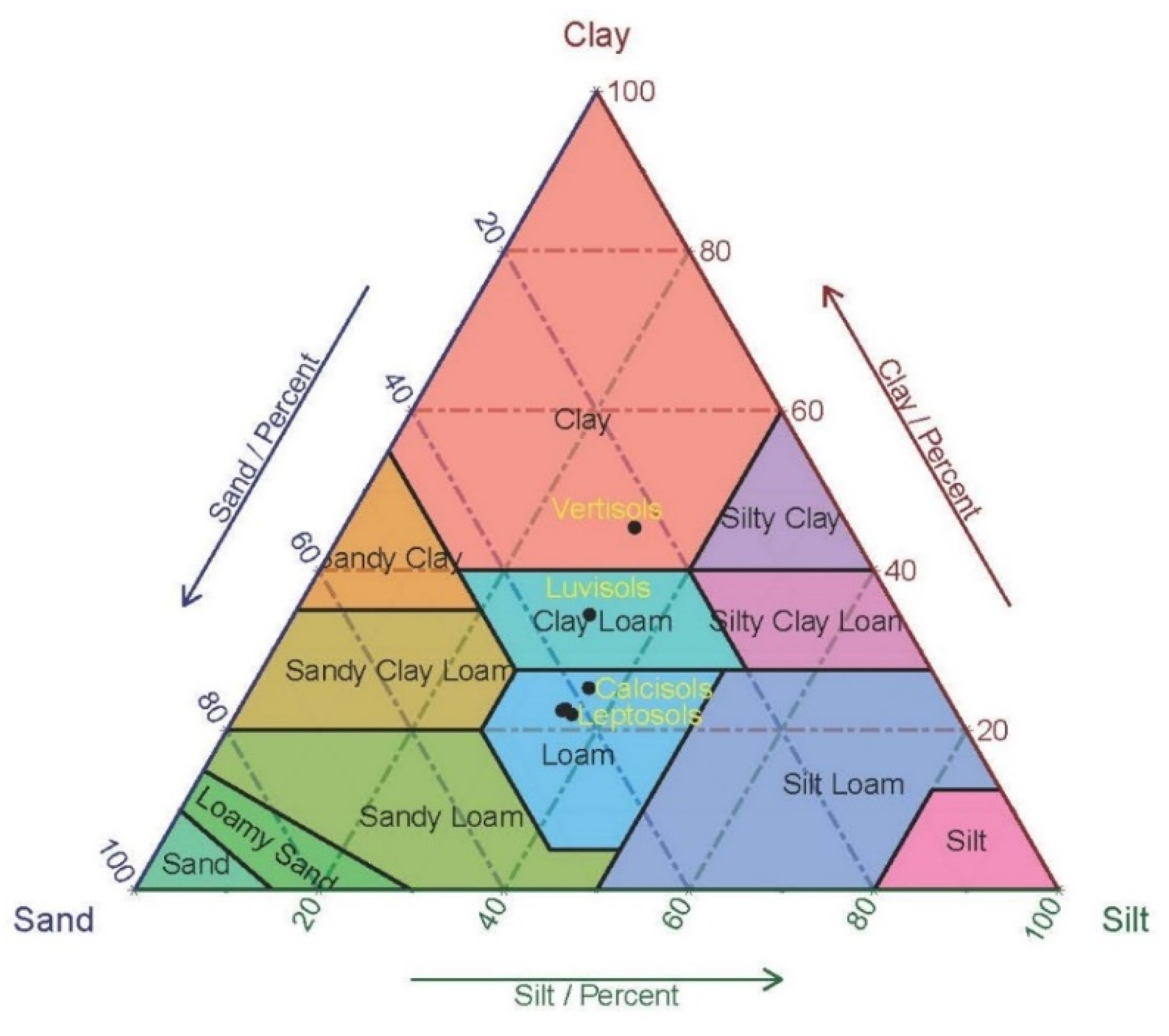
| Soil Group | Soil Type | Suitability |
|---|---|---|
| Leptosols A | Lithosols and Eutric Cambisols | Not suitable |
| Leptosols B | Lithosols, Rendzinas, and Calcic Xerosols | Not suitable |
| Leptosols C | Lithosols, Calcaric Regoso, and Calcic Xerosols | Not suitable |
| Luvisols | Chromic Luvisols, Calcic Cambisols, Lithosols, and Calcaric Regoso | Moderately suitable |
| Vertisols | Chromic Vertisols, and Calcic Xerosols | Most suitable |
| Calcisols | Calcic Xerosols, Rendzinas, and Chromic Vertisols | Less suitable |
| Dam | Coordinates | Buffer 100 | Buffer 500 | Buffer 250 | |||||||
|---|---|---|---|---|---|---|---|---|---|---|---|
| No. | X | Y | As | Aw | OA | As | Aw | OA | As | Aw | OA |
| 1 | 43.061066 | 37.10736 | 99.7 | 69.7 | 84.7 | 99.7 | 69.4 | 84.5 | 99.6 | 70.1 | 84.8 |
| 2 | 43.05568 | 37.18427 | 100 | 81.5 | 90.8 | 100 | 83.5 | 91.8 | 100 | 82.8 | 91.4 |
| 3 | 42.98572 | 37.14923 | 100 | 79.6 | 89.8 | 100 | 80.7 | 90.4 | 100 | 81.2 | 90.6 |
| 4 | 42.774496 | 37.28125 | 93.5 | 66.6 | 80.1 | 94.5 | 68.8 | 81.7 | 100 | 72.2 | 86.1 |
| 5 | 43.208654 | 37.20219 | 89.7 | 65.1 | 77.4 | 92.2 | 67.1 | 79.7 | 100 | 69.2 | 84.6 |
| 6 | 42.907832 | 37.15043 | 100 | 73.5 | 86.8 | 100 | 74.9 | 87.5 | 100 | 74.6 | 87.3 |
| 7 | 42.914868 | 37.02736 | 99.4 | 67.7 | 83.6 | 98.5 | 67.7 | 83.1 | 97.3 | 68.4 | 82.8 |
| 8 | 43.136919 | 37.10535 | 95.9 | 69 | 82.4 | 99.3 | 72.8 | 86.1 | 99.1 | 72.2 | 85.6 |
| 9 | 42.747988 | 37.30821 | 91.5 | 63.5 | 77.5 | 89.2 | 63.2 | 76.2 | 100 | 60 | 80 |
| 10 | 42.953957 | 37.09876 | 99.1 | 68.3 | 83.7 | 98.1 | 68.7 | 83.4 | 96.8 | 66.7 | 81.7 |
| 11 | 43.08669 | 37.13489 | 99.6 | 68.3 | 83.9 | 100 | 71 | 85.5 | 100 | 73.7 | 86.9 |
| Dam No. | Dam Width (m) | Lake Area (km2) | Volume (m3) | Depth (m) | Basin Area (km2) | Dam Profile | Nv | |||||
|---|---|---|---|---|---|---|---|---|---|---|---|---|
| Mean | Min | Max | X Start | Y Start | X End | Y End | ||||||
| 1 | 1109.9 | 8.61 | 226,654,026 | 26.33 | 624 | 670 | 2420.5 | 327929 | 4108249 | 327382 | 4109214 | 8 |
| 2 | 509.6 | 1.31 | 37,026,508 | 28.31 | 732 | 783 | 103.8 | 327516 | 4116203 | 327218 | 4116616 | 1 |
| 3 | 850 | 2.35 | 53,640,739 | 22.8 | 648 | 723 | 74.3 | 321553 | 4113344 | 320703 | 4113308 | 4 |
| 4 | 1069 | 3.44 | 274,350,307 | 79.85 | 716 | 845 | 149.7 | 303129 | 4128682 | 302214 | 4128066 | 1 |
| 5 | 667 | 5.34 | 421,706,403 | 78.91 | 748 | 864 | 266.9 | 340979 | 4118449 | 341072 | 4119110 | 2 |
| 6 | 443 | 0.46 | 5,769,178 | 12.57 | 606 | 627 | 26.3 | 314325 | 4113532 | 313951 | 4113768 | 0 |
| 7 | 817 | 4.39 | 191,423,581 | 43.58 | 604 | 668 | 219.9 | 314213 | 4099620 | 314786 | 4100203 | 1 |
| 8 | 1367 | 14.86 | 1,182,091,212 | 79.53 | 677 | 788 | 276.9 | 333616 | 4107771 | 334842 | 4108377 | 0 |
| 9 | 1148 | 3.93 | 341,654,356 | 86.99 | 626 | 751 | 184 | 299868 | 4131249 | 300953 | 4131627 | 1 |
| 10 | 372 | 1.6 | 55,823,171 | 34.97 | 579 | 631 | 35.6 | 318013 | 4107669 | 318314 | 4107887 | 0 |
| 11 | 737 | 6.04 | 199,256,701 | 32.97 | 648 | 706 | 1963.5 | 330258 | 4111289 | 329802 | 4111868 | 3 |
© 2020 by the authors. Licensee MDPI, Basel, Switzerland. This article is an open access article distributed under the terms and conditions of the Creative Commons Attribution (CC BY) license (http://creativecommons.org/licenses/by/4.0/).
Share and Cite
Othman, A.A.; Al-Maamar, A.F.; Al-Manmi, D.A.M.A.; Liesenberg, V.; Hasan, S.E.; Obaid, A.K.; Al-Quraishi, A.M.F. GIS-Based Modeling for Selection of Dam Sites in the Kurdistan Region, Iraq. ISPRS Int. J. Geo-Inf. 2020, 9, 244. https://doi.org/10.3390/ijgi9040244
Othman AA, Al-Maamar AF, Al-Manmi DAMA, Liesenberg V, Hasan SE, Obaid AK, Al-Quraishi AMF. GIS-Based Modeling for Selection of Dam Sites in the Kurdistan Region, Iraq. ISPRS International Journal of Geo-Information. 2020; 9(4):244. https://doi.org/10.3390/ijgi9040244
Chicago/Turabian StyleOthman, Arsalan Ahmed, Ahmed F. Al-Maamar, Diary Ali Mohammed Amin Al-Manmi, Veraldo Liesenberg, Syed E. Hasan, Ahmed K. Obaid, and Ayad M. Fadhil Al-Quraishi. 2020. "GIS-Based Modeling for Selection of Dam Sites in the Kurdistan Region, Iraq" ISPRS International Journal of Geo-Information 9, no. 4: 244. https://doi.org/10.3390/ijgi9040244
APA StyleOthman, A. A., Al-Maamar, A. F., Al-Manmi, D. A. M. A., Liesenberg, V., Hasan, S. E., Obaid, A. K., & Al-Quraishi, A. M. F. (2020). GIS-Based Modeling for Selection of Dam Sites in the Kurdistan Region, Iraq. ISPRS International Journal of Geo-Information, 9(4), 244. https://doi.org/10.3390/ijgi9040244