Research on Urban Ecological Network Under the Threat of Road Networks—A Case Study of Wuhan


Abstract
:1. Introduction
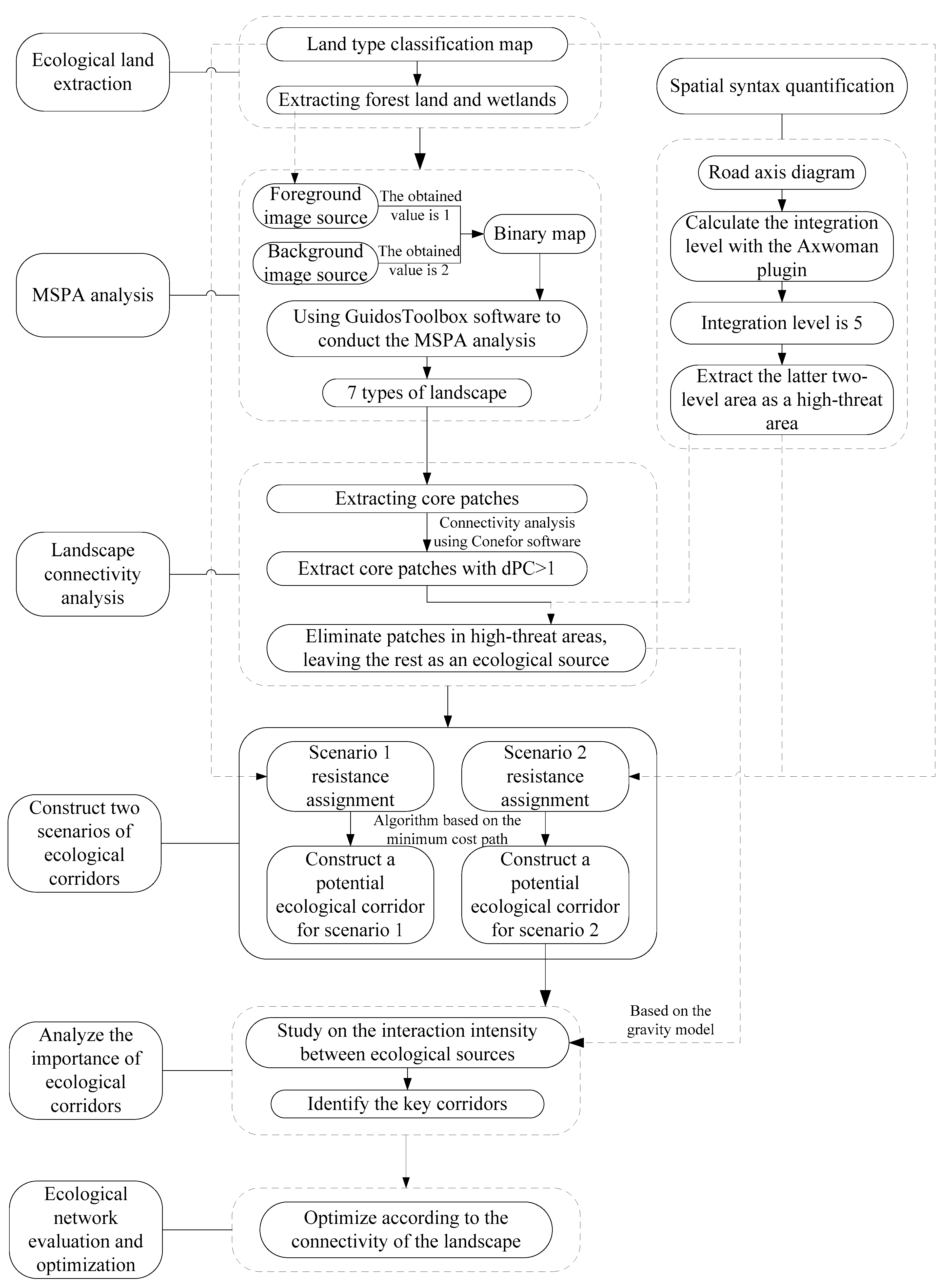
2. Research Theories and Methods
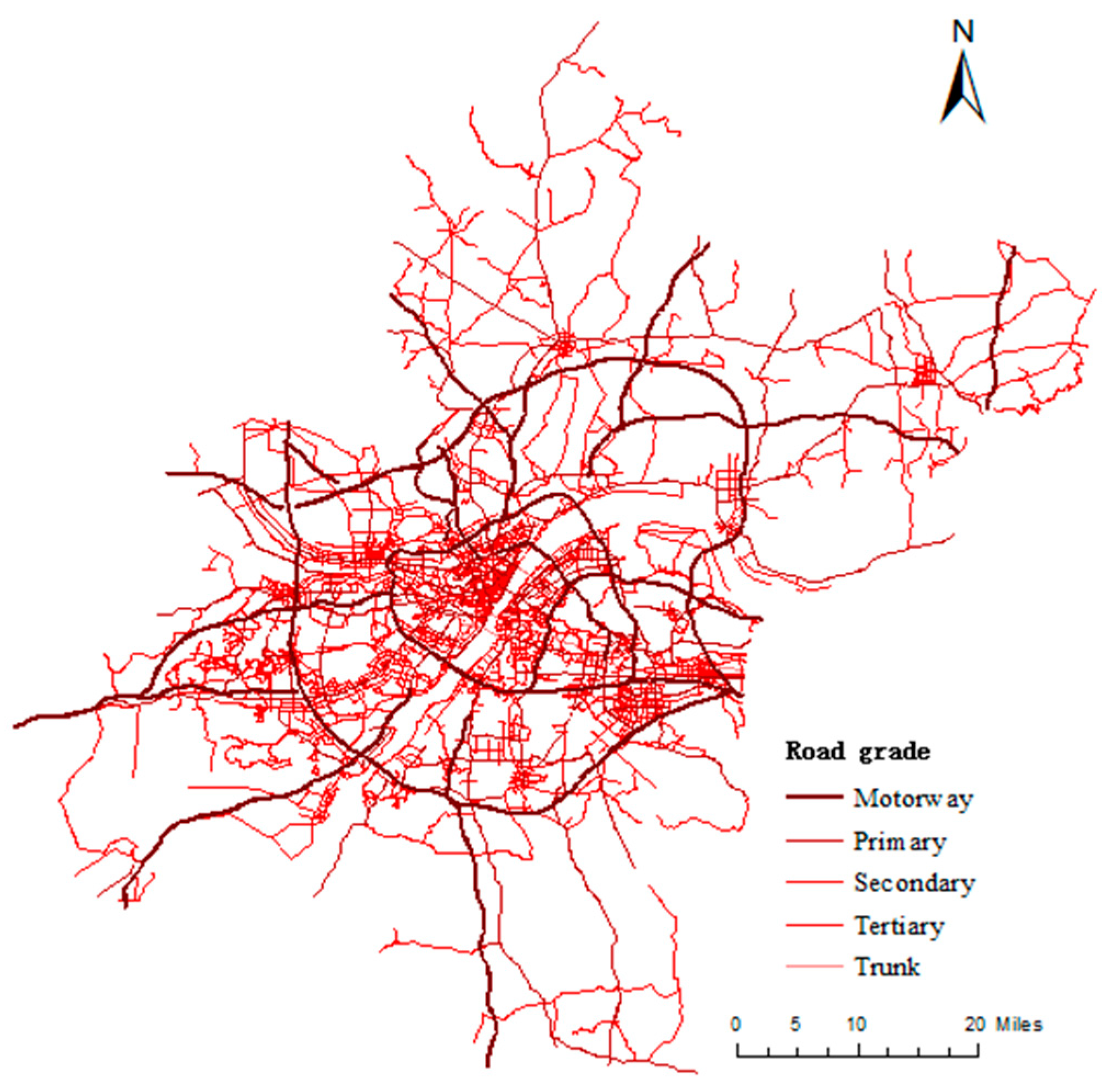
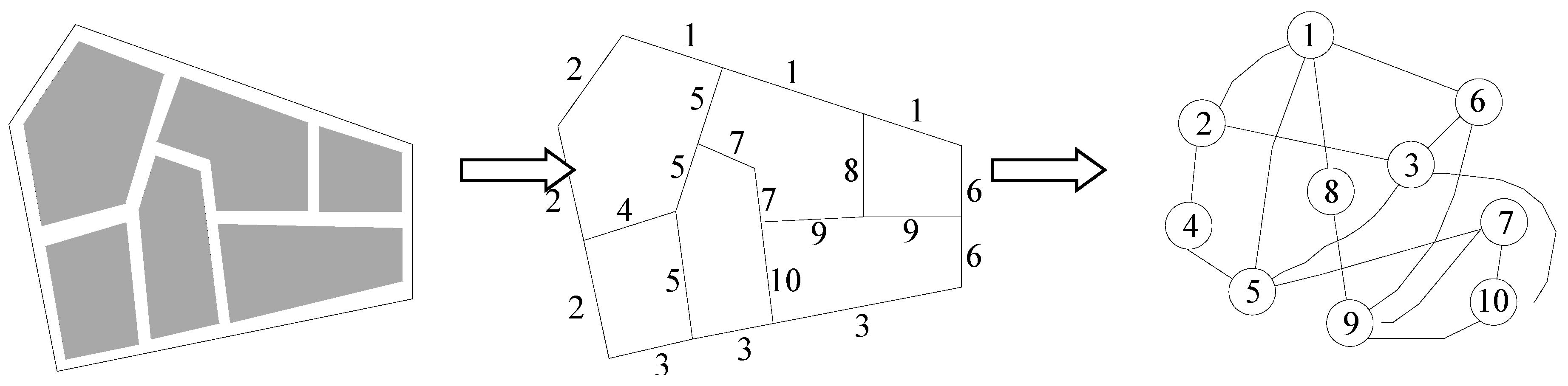
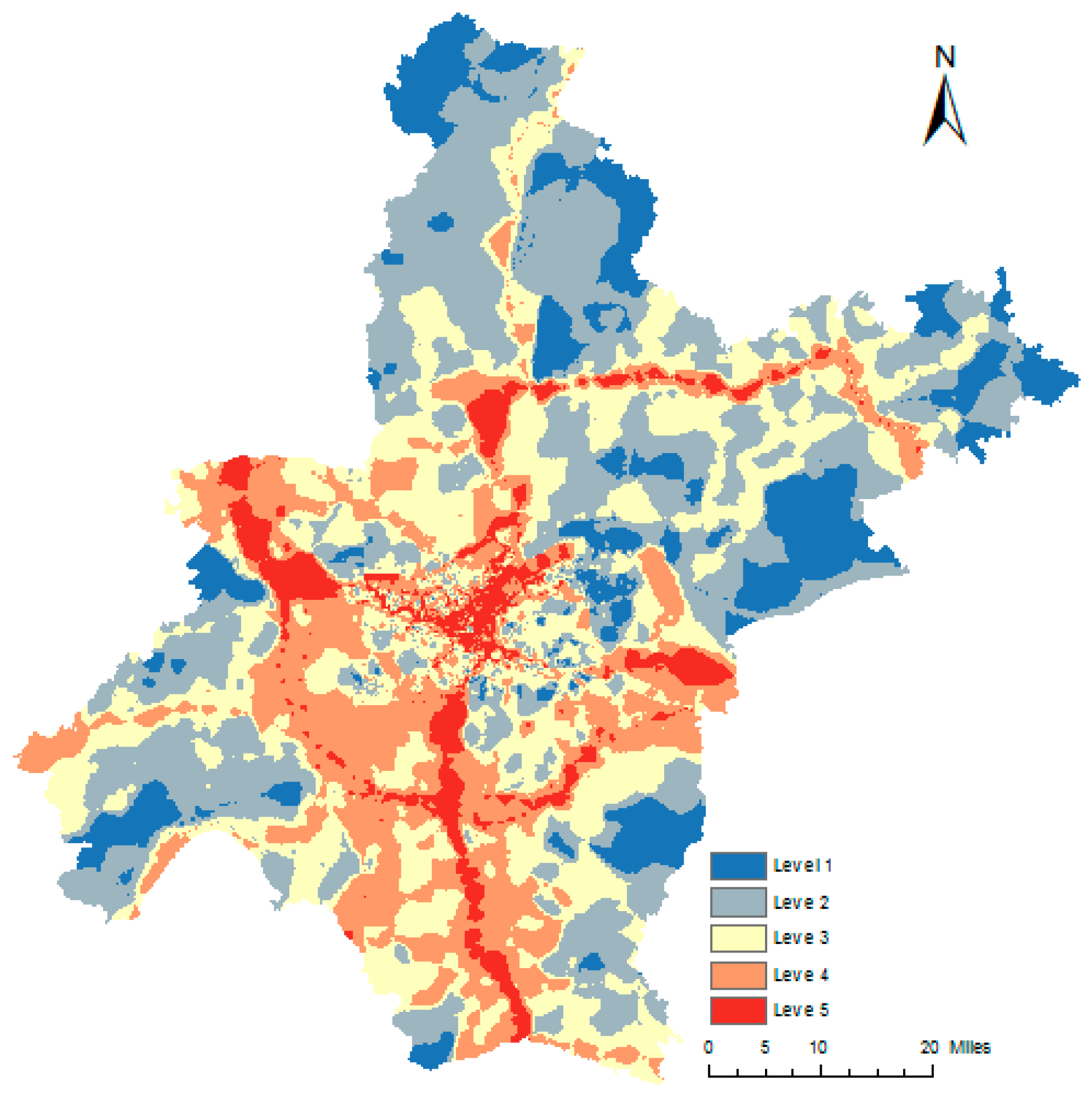
2.1. Space Syntax
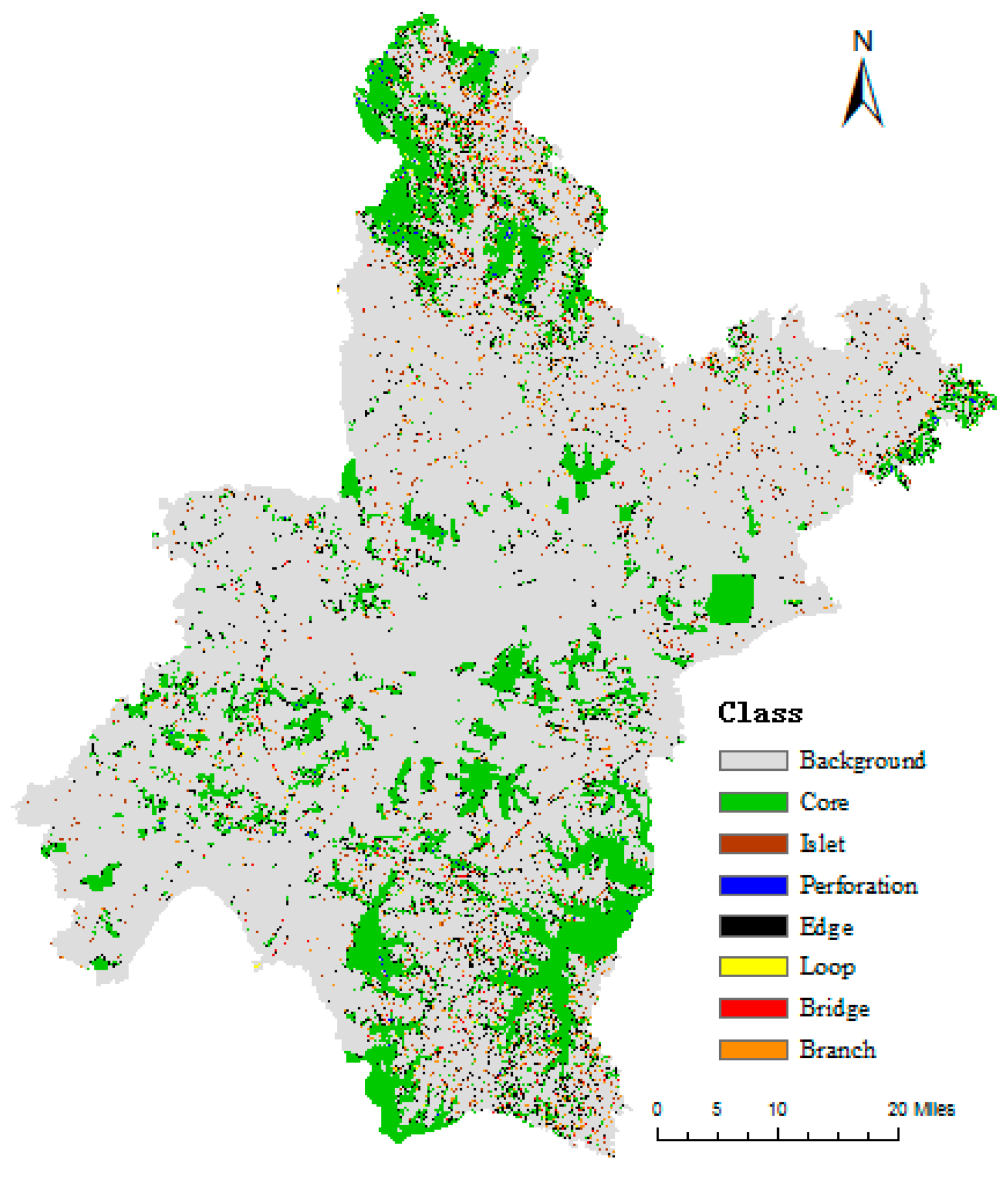
2.2. MSPA Method
2.3. Landscape Connectivity
2.4. Minimum Cumulative Resistance Model
2.5. Gravity Model and Network Connectivity Index
3. Case Study
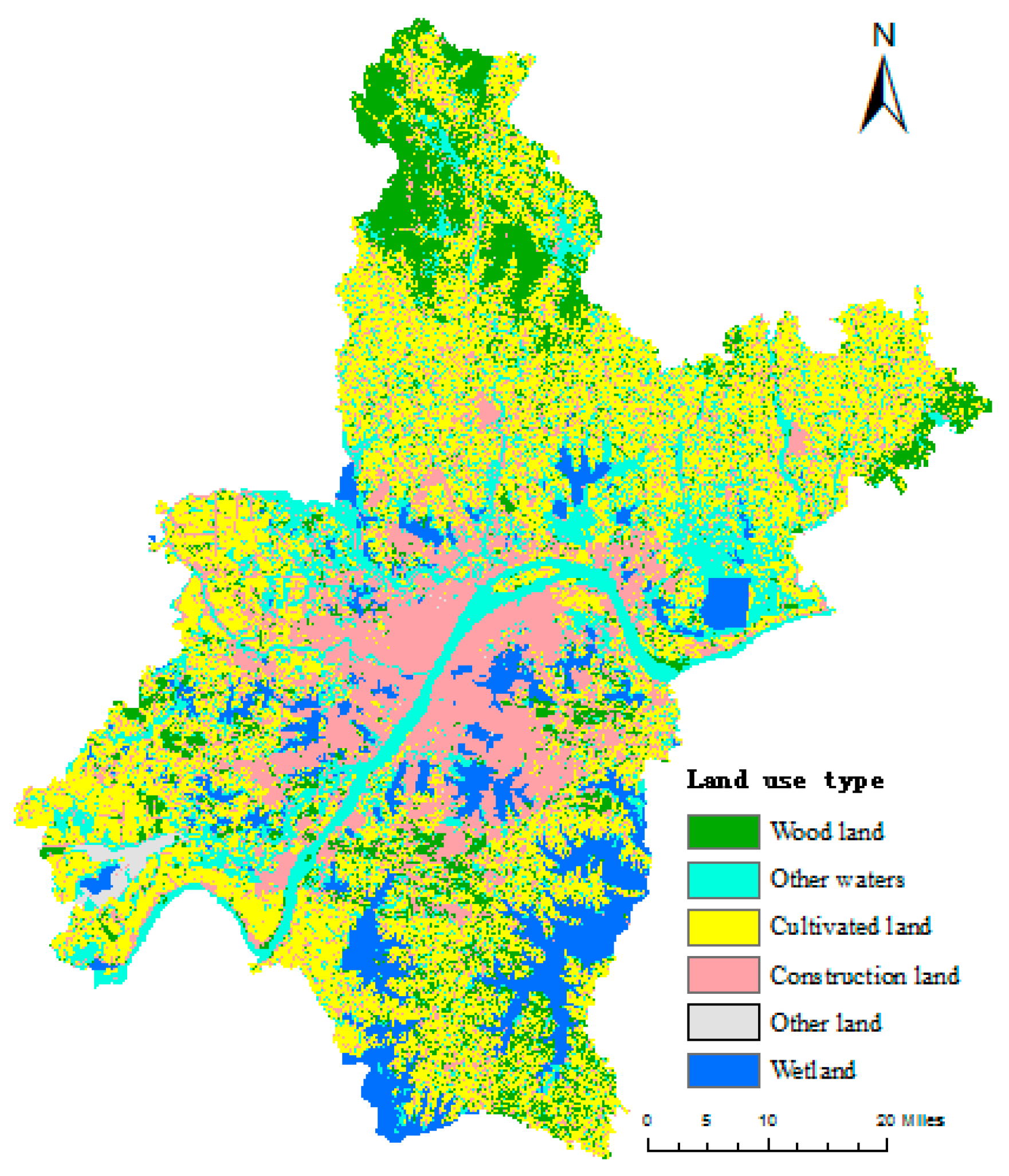
3.1. Data Source
3.2. Experimental Results and Analysis
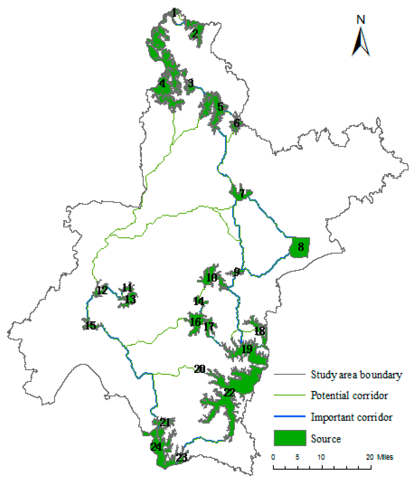
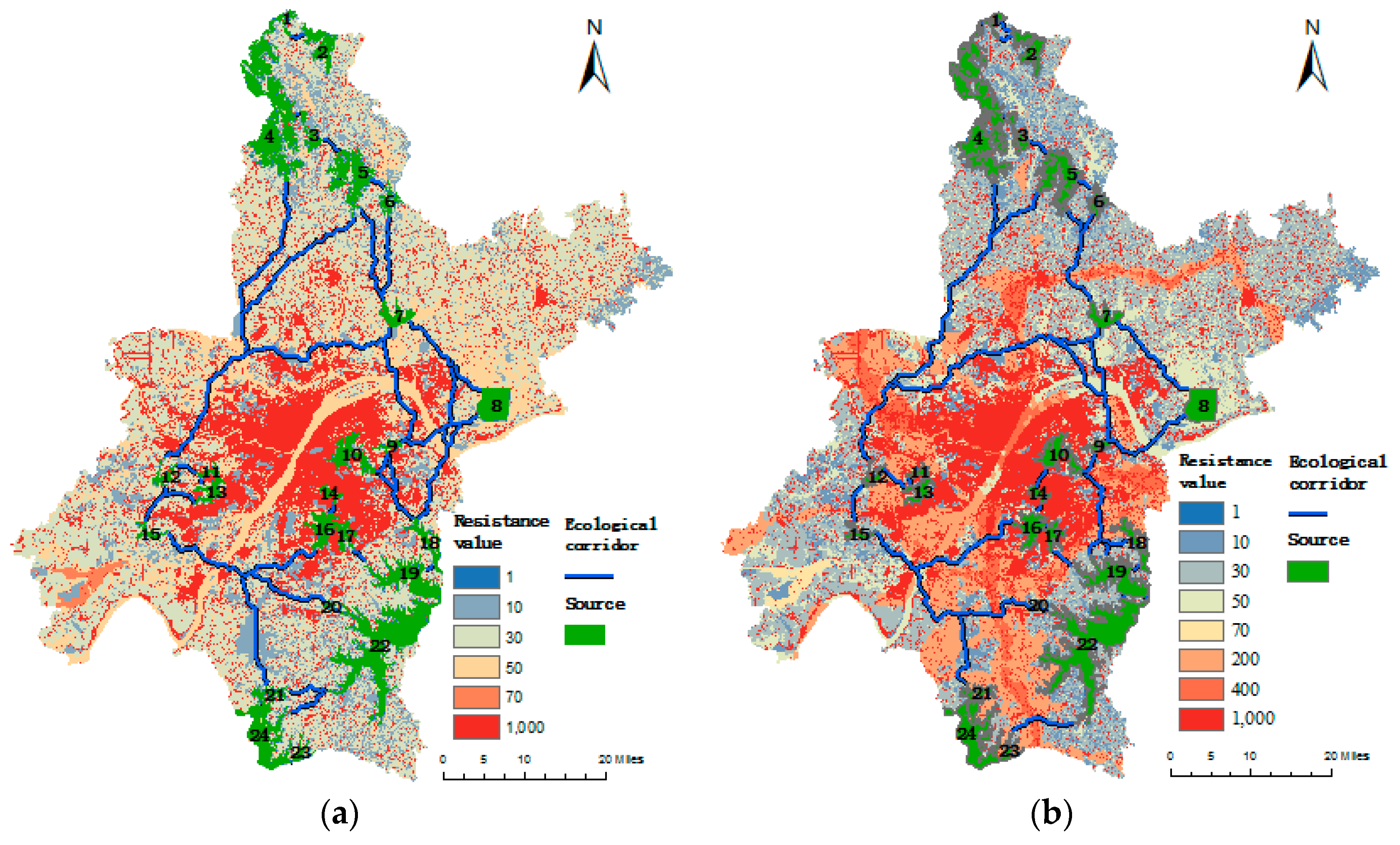
3.2.1. Source Selection Results and Analysis
3.2.2. Simulation Results and Analysis of Different Landscape Corridors
3.2.3. Ecological Network Evaluation and Optimization Analysis
4. Conclusions and Prospects
- (1)
- Space syntax can effectively describe the characteristics and distribution of road networks (including road density, road grade, connection strength, spatial layout, etc.).
- (2)
- Under the road network threat scenario, the average resistance of the study area was increased by 15.94%, and the length of the corridor increased by 37.9 km, indicating that a road network can increase the energy consumption of biological migration, change the biological migration path, and affect the spatial pattern of ecological processes.
- (3)
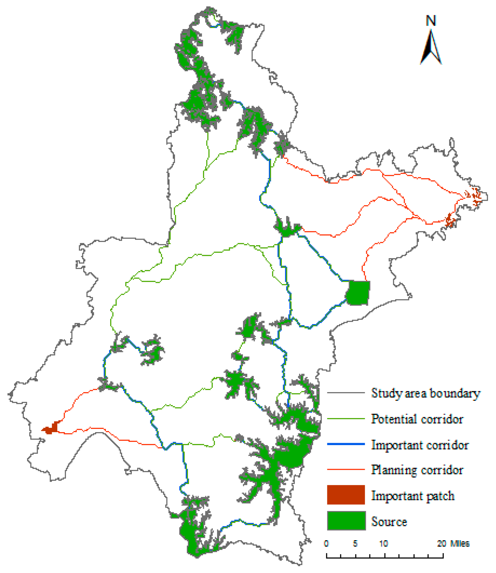
- According to the spatial distribution and connectivity of ecological patches in the study area, three important patches were added, which improved the overall connectivity of the study area and augmented the ecological network of the study area. In future urban construction, attention should be paid to protecting and conserving the existing ecological land, maintaining the sustainable development of the urban ecosystem, whilst avoiding greater ecological security problems.
Author Contributions
Funding
Acknowledgments
Conflicts of Interest
References
- Montis, A.D.; Caschili, S.; Mulas, M.; Modica, G.; Ganciu, A.; Bardi, A.; Ledda, A.; Dessena, L.; Laudari, L.; Fichera, C.R. Urban–rural ecological networks for landscape planning. Land Use Policy 2016, 50, 312–327. [Google Scholar] [CrossRef]
- Vimal, R.; Mathevet, R.; Thompson, J.D. The changing landscape of ecological networks. J. Nat. Conserv. (Jena) 2012, 20, 49–55. [Google Scholar] [CrossRef]
- Fichera, C.R.; Laudari, L.; Modica, G. Application, validation and comparison in different geographical contexts of an integrated model for the design of ecological networks. J. Agric. Eng. 2015, 46, 52–61. [Google Scholar] [CrossRef]
- Shi, H. Research on Urban Green Space Ecological Network Construction Technology Based on RS and GIS. Master’s Thesis, Nanjing Forestry University, Nanjing, China, 2010. [Google Scholar]
- Beier, P.; Spencer, W.; Baldwin, R.F.; McRae, B. Toward Best Practices for Developing Regional Connectivity Maps. Conserv. Biol. 2011, 25, 879–892. [Google Scholar] [CrossRef] [PubMed]
- Saura, S.; Vogt, P.; Velázquez, J.; Hernando, A.; Tejera, R. Key structural forest connectors can be identified by combining landscape spatial pattern and network analyses. For. Ecol. Manag. 2011, 262, 150–160. [Google Scholar] [CrossRef]
- Chen, Z.; Kuang, D.; Wei, X.J.; Zhang, L.T. Construction of Yujiang County Ecological Network Based on MSPA and MCR Models. Resour. Environ. Yangtze Basin 2017, 26, 92–100. [Google Scholar]
- Shi, N.N.; Han, Y.; Wang, Q.; Quan, Z.J.; Luo, Z.L.; Ge, J.S.; Han, R.Y.; Xiao, N.W. Construction and optimization of protected area ecological network in Qinghai Province. Chin. J. Ecol. 2018, 37, 1910–1916. [Google Scholar]
- Wang, Z.H.; Wang, D.C.; Hu, B.X.; Guo, Q.Z.; Xiu, L.N.; Zhao, H.T. Construction of ecological network in Yinzhou District of Tianjin considering landslide sensitivity. Acta Ecol. Sin. 2017, 38, 4351–4362. [Google Scholar]
- Benítez-López, A.; Alkemade, R.; Verweij, P.A. The impacts of roads and other infrastructure on mammal and bird populations: A meta-analysis. Biol. Conserv. 2010, 143, 1307–1316. [Google Scholar] [CrossRef] [Green Version]
- Coffin, A.W. From roadkill to road ecology: A review of the ecological effects of roads. J. Transp. Geogr. 2007, 15, 396–406. [Google Scholar] [CrossRef]
- Xu, F.; Yin, H.W.; Kong, F.H.; Xu, J.G. Construction of the ecological network of the western central city of Bazhong based on MSPA and minimum path method. Acta Ecol. Sin. 2015, 35, 6425–6434. [Google Scholar]
- Jia, Z.Y.; Chen, C.D.; Tong, X.X.; Wu, S.J.; Zhou, W.Z. Construction and Optimization of Ecological Network in the Three Gorges Reservoir Towns—Taking Kaizhou New City in Chongqing as an Example. Chin. J. Ecol. 2017, 36, 782–791. [Google Scholar]
- Pan, J.H.; Liu, X. Ecological security assessment and pattern optimization of inland river landscape based on spatial principal component and minimum cumulative resistance model: A case study of Ganzhou District, Zhangye City. Chin. J. Appl. Ecol. 2015, 26, 3126–3136. [Google Scholar]
- Gurrutxaga, M.; Lozano, P.J.; Barrio, G.D. GIS-based approach for incorporating the connectivity of ecological networks into regional planning. J. Nat. Conserv. 2010, 18, 318–326. [Google Scholar] [CrossRef]
- Liu, R.C.; Shen, C.Z.; Jia, Z.Y.; Wang, J.X.; Lu, C.F.; Zhou, S.L. Construction and optimization of ecological network along beaches under road landscape stress: Taking Dafeng District of Yancheng City as an example. Chin. J. Ecol. 2019, 38, 828–837. [Google Scholar]
- Jiang, B.; Claramunt, C. Integration of Space Syntax into GIS: New Perspectives for Urban Morphology. Trans. GIS 2002, 6, 295–309. [Google Scholar] [CrossRef]
- Hiller, B. Space is the Machine; Cambridge University Press: Cambridge, UK, 2007. [Google Scholar]
- Soille, P.; Vogt, P. Morphological segmentation of binary patterns. Pattern Recognit. Lett. 2009, 30, 456–459. [Google Scholar] [CrossRef]
- Qiu, Y.; Chang, Q.; Wang, J. Urban Green Infrastructure Network Planning Based on MSPA—Taking Shenzhen City as an Example. Chin. Landsc. Archit. 2013, 5, 104–108. [Google Scholar]
- Yu, K.J. Landscape ecological security pattern of biological protection. Acta Ecol. Sin. 1997, 19, 10–17. [Google Scholar]
- Knaapen, J.P.; Scheffer, M.; Harms, B. Estimating habitat isolation in landscape planning. Landsc. Urban Plan. 1992, 23, 1–16. [Google Scholar] [CrossRef]
- Yang, Y.Q.; Ren, P.; Hong, B.T. Development and Utilization of Low Slope Landslide in the Hinterland of the Three Gorges Reservoir Area Based on Ecological Security Pattern. Res. Soil Water Conserv. 2019, 26, 305–310. [Google Scholar]
- Liu, X.F.; Shu, Y.M.; Zhang, L.B. Application of Minimum Cumulative Resistance Model in Urban Land Ecological Suitability Evaluation—Taking Xiamen as an Example. Acta Ecol. Sin. 2010, 30, 421–428. [Google Scholar]
- Kong, F.H.; Yin, H.W. Construction of urban green space ecological network in Jinan. Acta Ecol. Sin. 2008, 28, 1711–1719. [Google Scholar]
- Chen, C.D.; Jia, Z.Y.; Wu, S.J.; Tong, X.X.; Zhou, W.Z.; Chen, R.Y.; Zhang, C.L. A bibliometric review of Chinese studies on the application of landscape connectivity. Acta Ecol. Sin. 2017, 37, 3243–3255. [Google Scholar] [Green Version]
- Liu, C.F.; Zhou, B.; He, X.Y.; Chen, W. Selection of distance threshold for urban forest landscape connectivity in Shenyang. Chin. J. Appl. Ecol. 2010, 21, 2508–2516. [Google Scholar]
- Yu, Y.P.; Yin, H.W.; Kong, F.H.; Wang, J.J.; Xu, W.B. Scale effect of network structure and connectivity analysis of green infrastructure in Nanjing. Chin. J. Appl. Ecol. 2016, 27, 2119–2127. [Google Scholar]


| Parameter | Formula | Significance |
|---|---|---|
| Connection degree (Ci) | k represents the number of nodes directly connected to the i-th node. | |
| Depth value (Di) | di represents the sum of the shortest distance between the i-th node and all the remaining nodes (the minimum number of steps, and the distance between two adjacent nodes is 1 step). | |
| Integration (RAi) | n represents the number of nodes. |
| Landscape type | Ecological Implications |
|---|---|
| Core | A habitat patch with a large pixel. It can provide a spacious habitat for organisms and therefore is important for species reproduction and biodiversity conservation. It is the ecological source of ecological networks. |
| Islet | A small, isolated, fragmented patch with a low connectivity to other patches and less possibility of material and energy exchange. |
| Perforation | The transition zone between the core patch and its interior non-green space, i.e. the edge interior patch (Edge Effect). |
| Edge | The transition zone between the edge of the core area and the surrounding non-green landscape area. It can reduce the impact of external environment and human interference. |
| Loop | The internal channel connecting the same core area, which is a shortcut for the exchange of material and energy within the core area. |
| Bridge | The long and narrow area connected with the core area. It has the characteristics of ecological corridor, which is conducive to species migration and the connection of landscapes within the country. |
| Branch | An area with only one end connected to an edge, a bridge, an island or a pore, mainly an extension of green space, and a channel for species diffusion and energy exchange with the surrounding landscape. |
| Landscape Connectivity Index | Formula | Significance |
|---|---|---|
| IIC | n represents the total number of patches in the landscape; ai and aj represent the area of patch i and patch j; nlij represents topological distance between patch i and j (minimum number of links that have to be passed to move from i to j); AL is the total area of the landscape; dij is the Euclidean distance between patch i and jk is a constant; PCremove is the connectivity index value of the landscape after the patch i is removed from the landscape. | |
| PC | ||
| dPC |
| Landscape Type | Area/km2 | Percentage of Total Area of Ecological Land/% |
|---|---|---|
| Core | 1257.15 | 66.23 |
| Islet | 102.83 | 5.42 |
| Perforation | 11.14 | 0.61 |
| Edge | 373.63 | 19.68 |
| Loop | 11.14 | 0.57 |
| Bridge | 23.14 | 1.24 |
| Branch | 119.12 | 6.25 |
| Total | 1898.15 | 100 |
| Sort | Source Number | Area/km2 | dPC |
|---|---|---|---|
| 1 | 22 | 154.16 | 38.30 |
| 2 | 4 | 132.63 | 17.43 |
| 3 | 19 | 51.32 | 15.91 |
| 4 | 24 | 63.18 | 12.14 |
| 5 | 5 | 51.97 | 8.39 |
| 6 | 16 | 24.59 | 7.45 |
| 7 | 10 | 29.36 | 5.81 |
| 8 | 18 | 18.77 | 5.33 |
| 9 | 21 | 10.98 | 4.65 |
| 10 | 17 | 11.85 | 4.31 |
| 11 | 2 | 26.09 | 3.53 |
| 12 | 3 | 12.43 | 3.48 |
| 13 | 8 | 38.06 | 3.06 |
| 14 | 14 | 6.77 | 2.73 |
| 15 | 13 | 13.25 | 2.14 |
| 16 | 1 | 6.74 | 1.93 |
| 17 | 7 | 17.66 | 1.72 |
| 18 | 20 | 2.09 | 1.55 |
| 19 | 23 | 7.21 | 1.54 |
| 20 | 6 | 11.18 | 1.46 |
| 21 | 12 | 7.99 | 1.40 |
| 22 | 11 | 5.09 | 1.28 |
| 23 | 9 | 6.53 | 1.23 |
| 24 | 15 | 7.67 | 1.06 |
| Resistance Factor | Situation 1 | Situation 2 |
|---|---|---|
| Source region | 1 | 1 |
| Forest land | 10 | 10 |
| Wetland | 10 | 10 |
| Cultivated land | 30 | 30 |
| Other water are | 50 | 50 |
| Construction land | 1000 | 1000 |
| Other land | 70 | 70 |
| Road factor Grade 4 | / | 200 |
| Road factor Grade 5 | / | 400 |
| 7 | 1 | 2 | 3 | 4 | 5 | 6 | 7 | 8 | 9 | 10 | 11 | 12 | 13 | 14 | 15 | 16 | 17 | 18 | 19 | 20 | 21 | 22 | 23 | 24 |
|---|---|---|---|---|---|---|---|---|---|---|---|---|---|---|---|---|---|---|---|---|---|---|---|---|
| 1 | 0 | |||||||||||||||||||||||
| 2 | 79,933 | 0 | ||||||||||||||||||||||
| 3 | 68,898 | 32,396 | 0 | |||||||||||||||||||||
| 4 | 178,560 | 72,762 | 652,933 | 0 | ||||||||||||||||||||
| 5 | 14,704 | 14,114 | 47,848 | 55,541 | 0 | |||||||||||||||||||
| 6 | 4109 | 4672 | 9533 | 13,574 | 63,840 | 0 | ||||||||||||||||||
| 7 | 448 | 670 | 690 | 1234 | 1420 | 953 | 0 | |||||||||||||||||
| 8 | 141 | 225 | 201 | 375 | 357 | 227 | 844 | 0 | ||||||||||||||||
| 9 | 46 | 75 | 65 | 122 | 112 | 71 | 191 | 637 | 0 | |||||||||||||||
| 10 | 75 | 122 | 105 | 198 | 181 | 114 | 292 | 882 | 29,504 | 0 | ||||||||||||||
| 11 | 5 | 8 | 6 | 12 | 9 | 5 | 6 | 6 | 3 | 5 | 0 | |||||||||||||
| 12 | 10 | 16 | 13 | 26 | 20 | 12 | 13 | 12 | 6 | 11 | 94 | 0 | ||||||||||||
| 13 | 7 | 12 | 10 | 19 | 15 | 9 | 10 | 10 | 5 | 9 | 21,150 | 153 | 0 | |||||||||||
| 14 | 6 | 10 | 8 | 15 | 13 | 8 | 12 | 19 | 14 | 27 | 4 | 7 | 6 | 0 | ||||||||||
| 15 | 9 | 14 | 11 | 22 | 17 | 10 | 12 | 11 | 6 | 11 | 65 | 3167 | 105 | 8 | 0 | |||||||||
| 16 | 9 | 15 | 12 | 24 | 20 | 12 | 18 | 28 | 21 | 39 | 9 | 18 | 15 | 417 | 20 | 0 | ||||||||
| 17 | 7 | 12 | 10 | 19 | 16 | 10 | 15 | 23 | 17 | 31 | 7 | 14 | 11 | 273 | 16 | 72,620 | 0 | |||||||
| 18 | 13 | 22 | 18 | 34 | 29 | 18 | 29 | 47 | 29 | 76 | 11 | 29 | 18 | 66 | 34 | 322 | 282 | 0 | ||||||
| 19 | 18 | 29 | 24 | 46 | 39 | 24 | 39 | 63 | 53 | 101 | 16 | 40 | 25 | 92 | 47 | 463 | 407 | 315,875 | 0 | |||||
| 20- | 3 | 5 | 4 | 8 | 7 | 4 | 7 | 11 | 9 | 18 | 3 | 8 | 5 | 16 | 9 | 78 | 68 | 8993 | 32,320 | 0 | ||||
| 21 | 6 | 10 | 8 | 16 | 13 | 8 | 12 | 18 | 13 | 25 | 13 | 40 | 21 | 19 | 49 | 55 | 45 | 151 | 215 | 40 | 0 | |||
| 22 | 22 | 37 | 30 | 58 | 50 | 31 | 49 | 80 | 67 | 128 | 20 | 52 | 32 | 116 | 61 | 575 | 505 | 204,362 | 3,253,449 | 73,681 | 282 | 0 | ||
| 23 | 5 | 8 | 7 | 12 | 11 | 6 | 10 | 14 | 10 | 19 | 9 | 24 | 14 | 14 | 29 | 40 | 33 | 103 | 146 | 27 | 1342 | 191 | 0 | |
| 24 | 11 | 18 | 14 | 28 | 23 | 14 | 21 | 32 | 23 | 43 | 23 | 69 | 37 | 33 | 84 | 96 | 78 | 267 | 379 | 70 | 2,597,833 | 497 | 2484 | 0 |
© 2019 by the authors. Licensee MDPI, Basel, Switzerland. This article is an open access article distributed under the terms and conditions of the Creative Commons Attribution (CC BY) license (http://creativecommons.org/licenses/by/4.0/).
Share and Cite
Miao, Z.; Pan, L.; Wang, Q.; Chen, P.; Yan, C.; Liu, L. Research on Urban Ecological Network Under the Threat of Road Networks—A Case Study of Wuhan. ISPRS Int. J. Geo-Inf. 2019, 8, 342. https://doi.org/10.3390/ijgi8080342
Miao Z, Pan L, Wang Q, Chen P, Yan C, Liu L. Research on Urban Ecological Network Under the Threat of Road Networks—A Case Study of Wuhan. ISPRS International Journal of Geo-Information. 2019; 8(8):342. https://doi.org/10.3390/ijgi8080342
Chicago/Turabian StyleMiao, Zuohua, Lei Pan, Qiaozhi Wang, Pei Chen, Cheng Yan, and Likun Liu. 2019. "Research on Urban Ecological Network Under the Threat of Road Networks—A Case Study of Wuhan" ISPRS International Journal of Geo-Information 8, no. 8: 342. https://doi.org/10.3390/ijgi8080342
APA StyleMiao, Z., Pan, L., Wang, Q., Chen, P., Yan, C., & Liu, L. (2019). Research on Urban Ecological Network Under the Threat of Road Networks—A Case Study of Wuhan. ISPRS International Journal of Geo-Information, 8(8), 342. https://doi.org/10.3390/ijgi8080342