An Integrated BIM–GIS Method for Planning of Water Distribution System


Abstract
:1. Introduction
2. Literature Review
2.1. Integration of BIM and GIS
2.2. Previous Studies of Water Distribution Systems (WDSs)
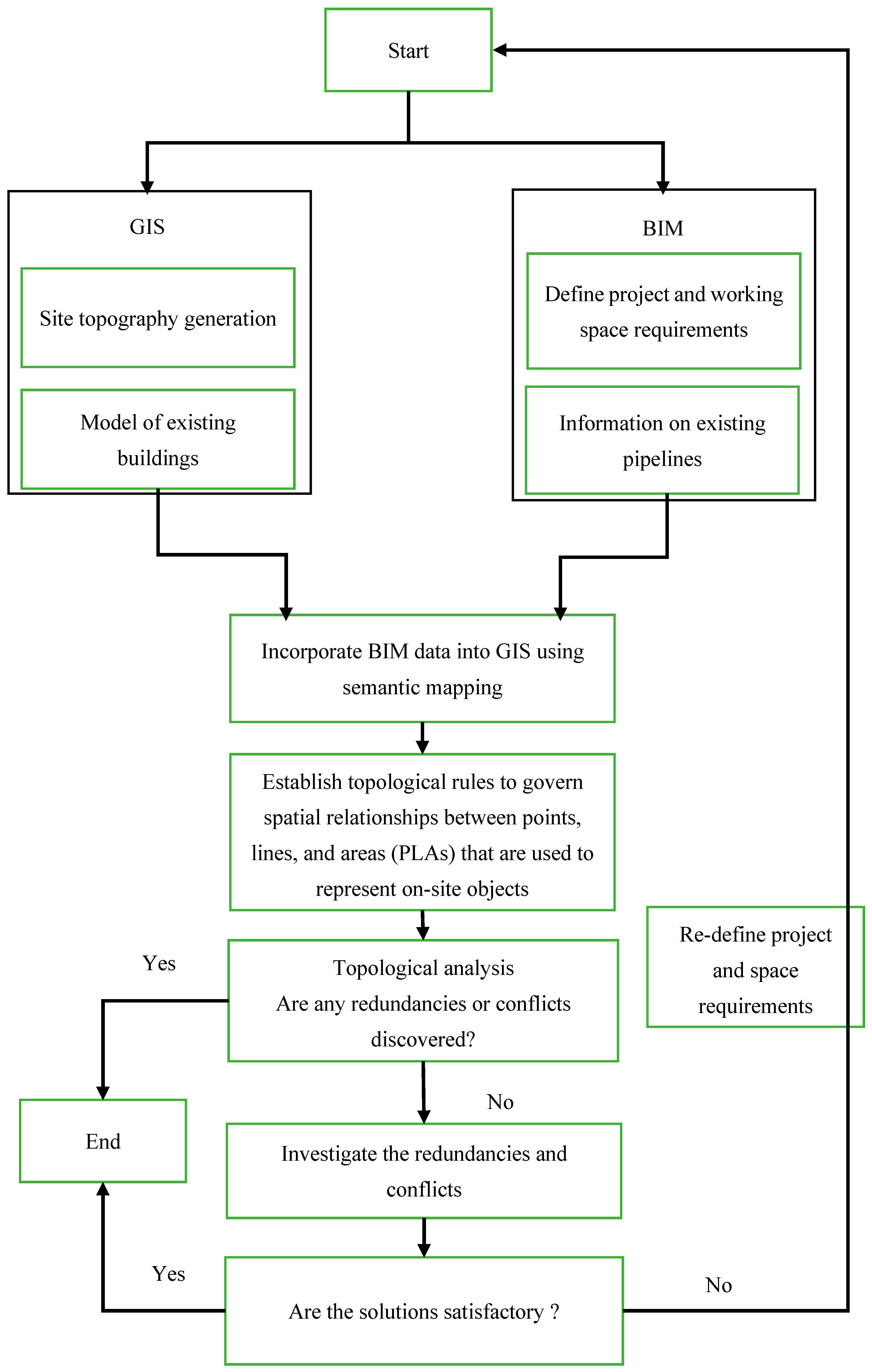
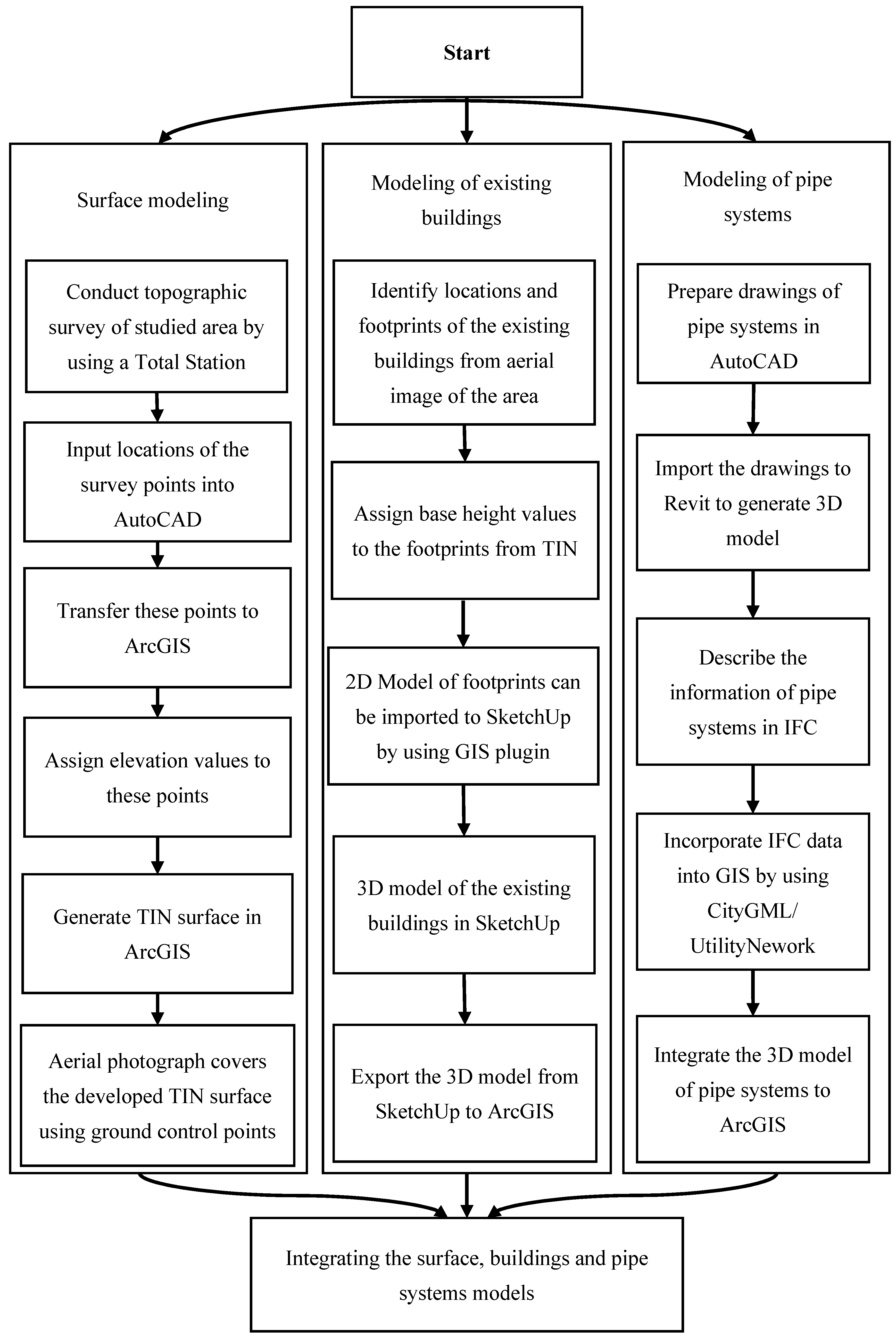
3. Proposed Method
3.1. Semantic Mapping
3.1.1. IFC Schema
3.1.2. CityGML Schema
3.1.3. Mapping IFC Data into CityGML System
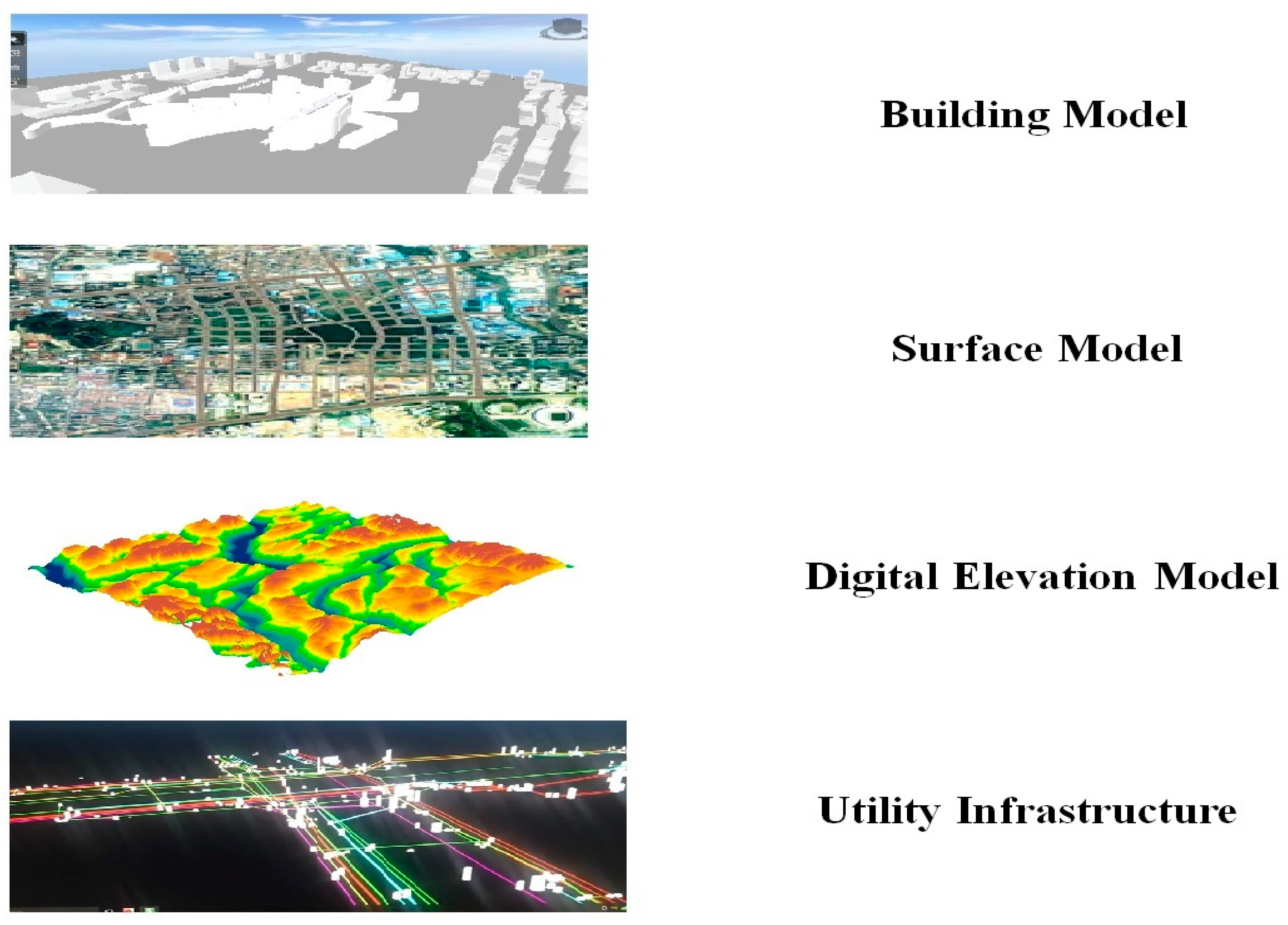
3.2. 3D Visualization Model
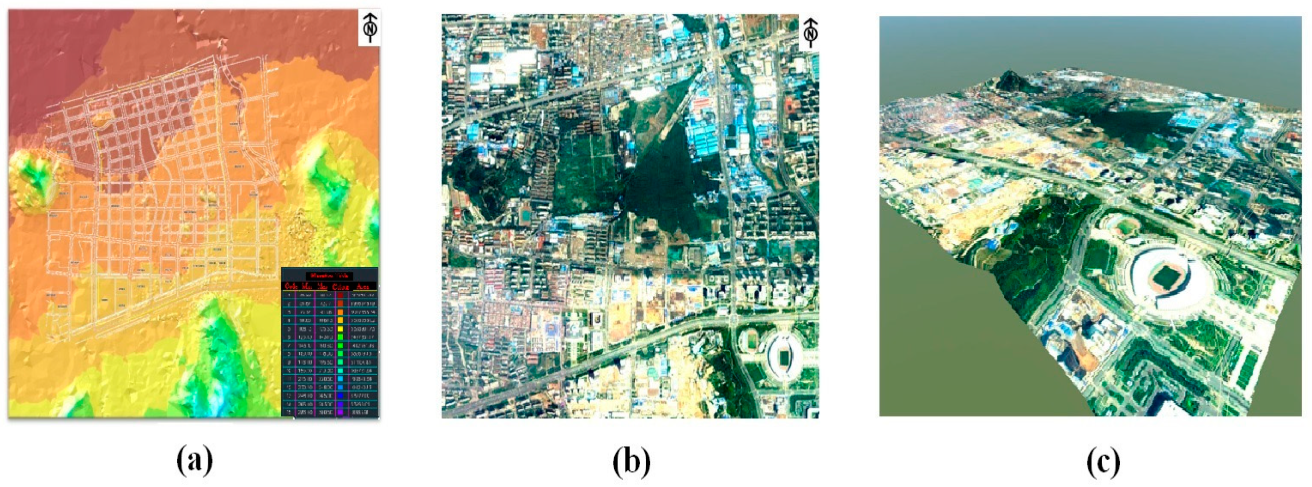
3.2.1. Surface Model
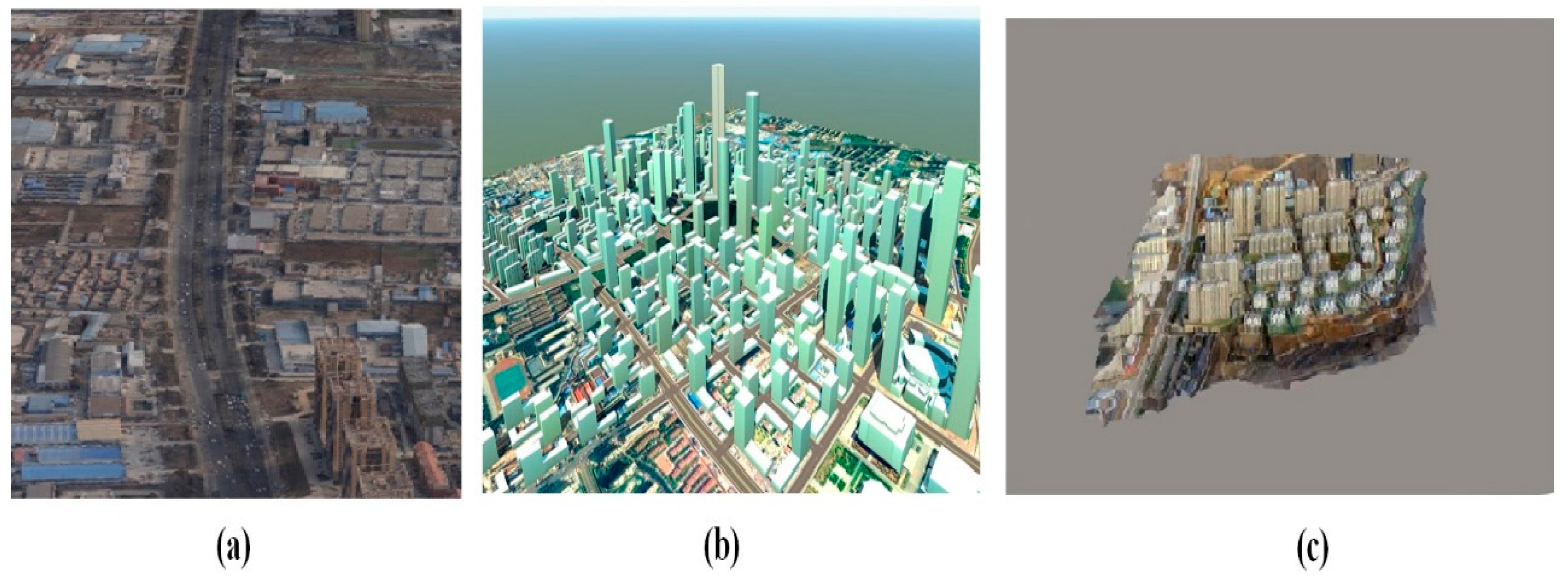
3.2.2. Modeling of Existing Buildings
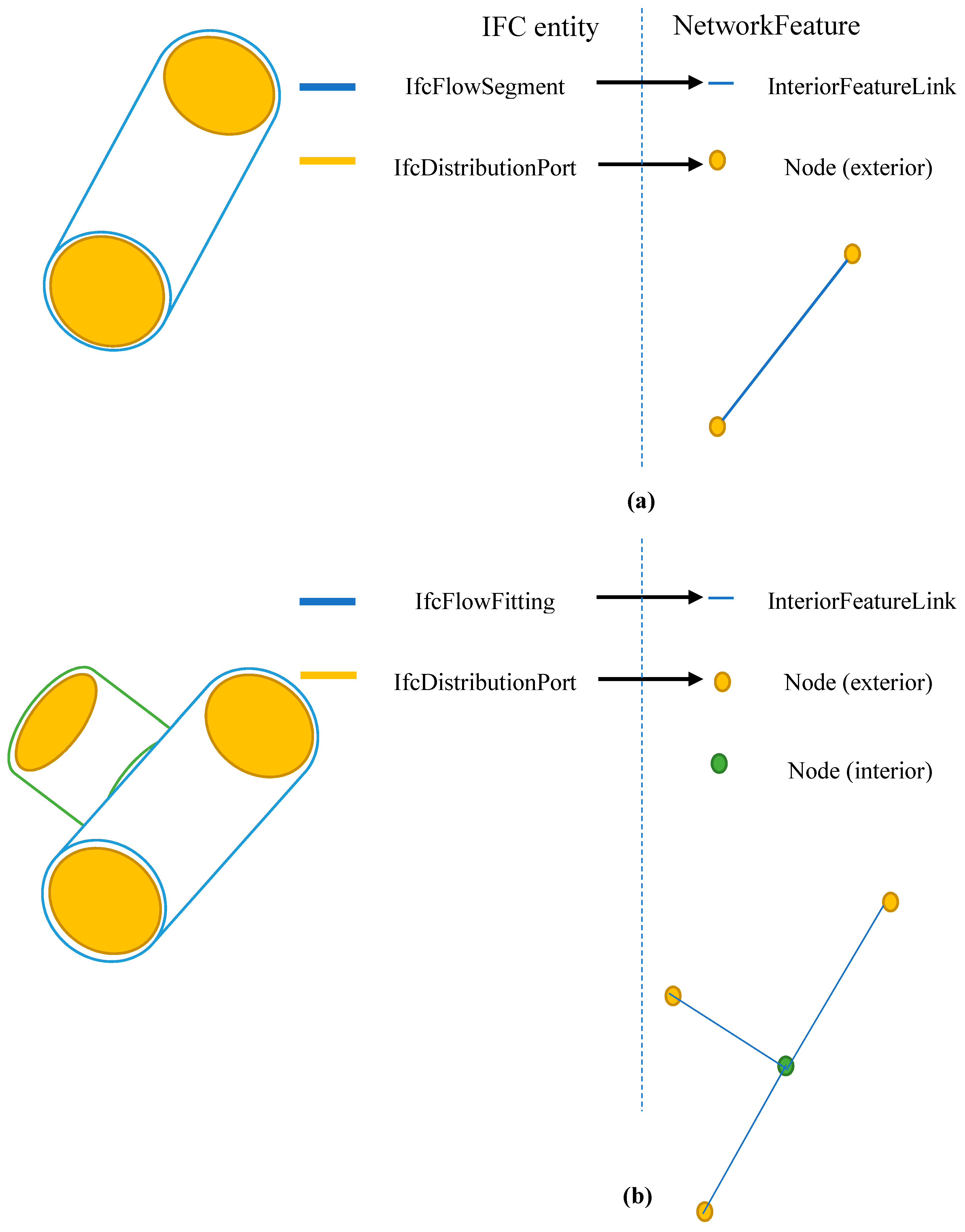
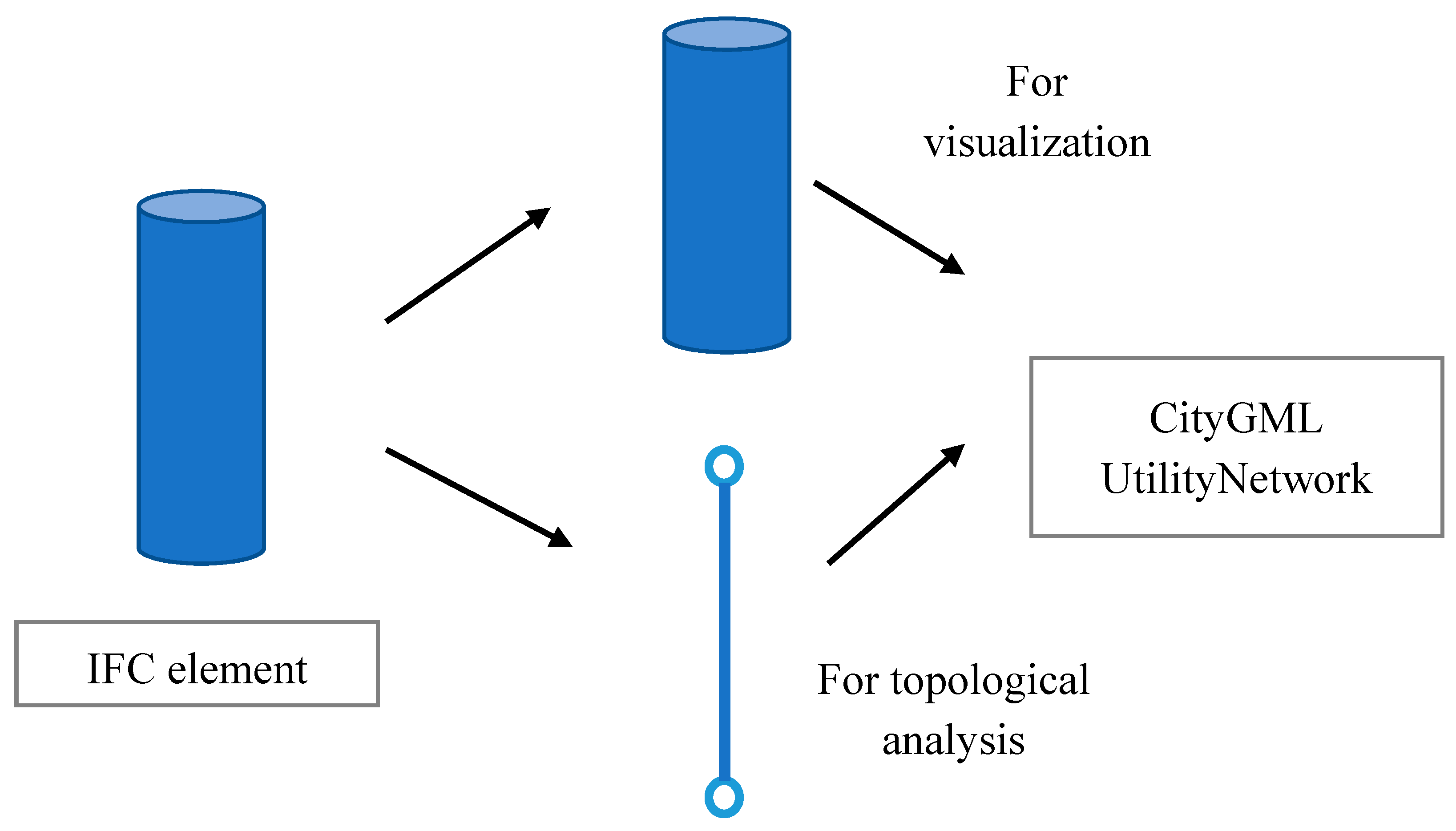
3.2.3. Modeling of Pipe Network Systems
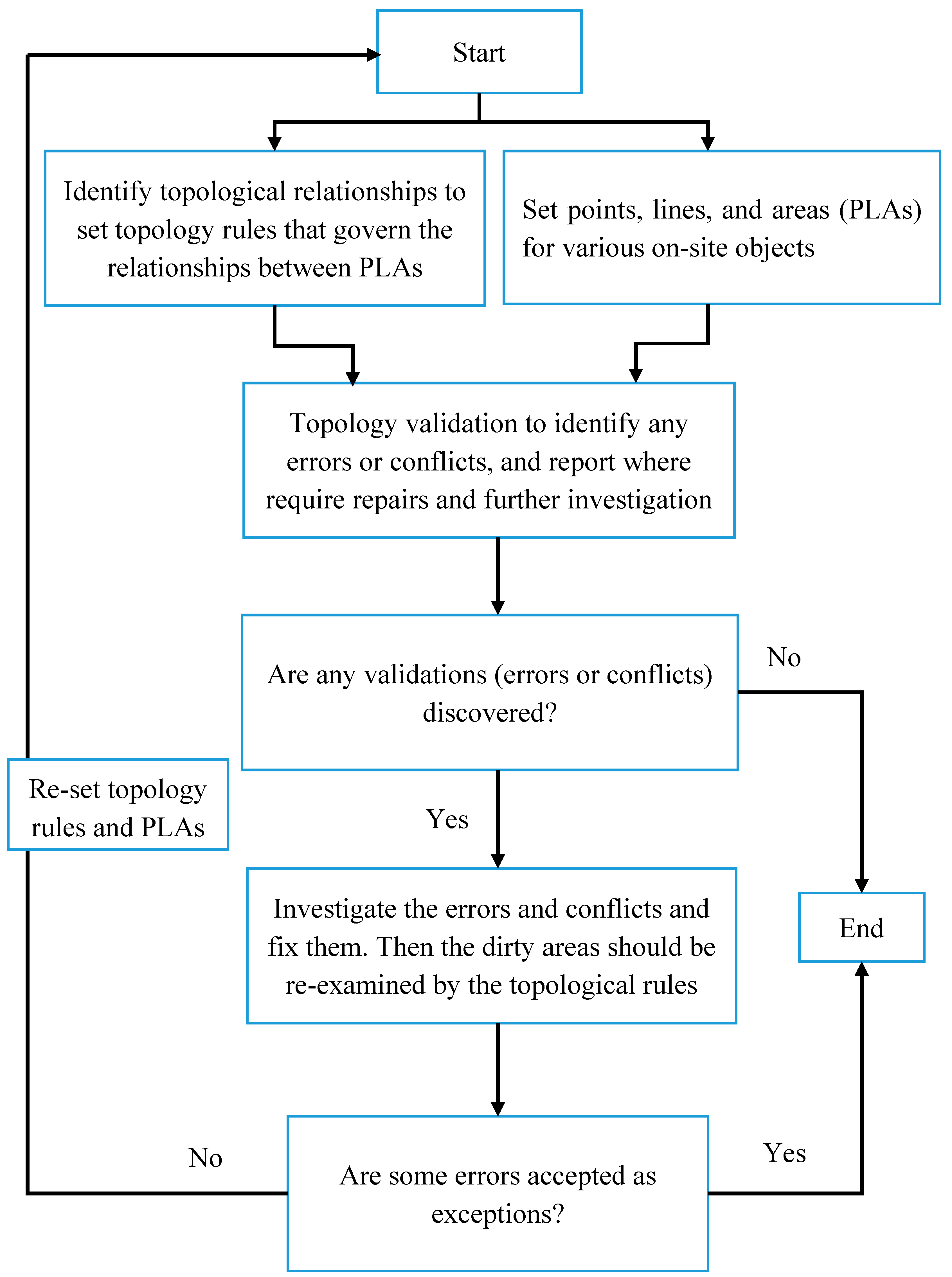
3.3. Topological Validation Process
4. Implementation
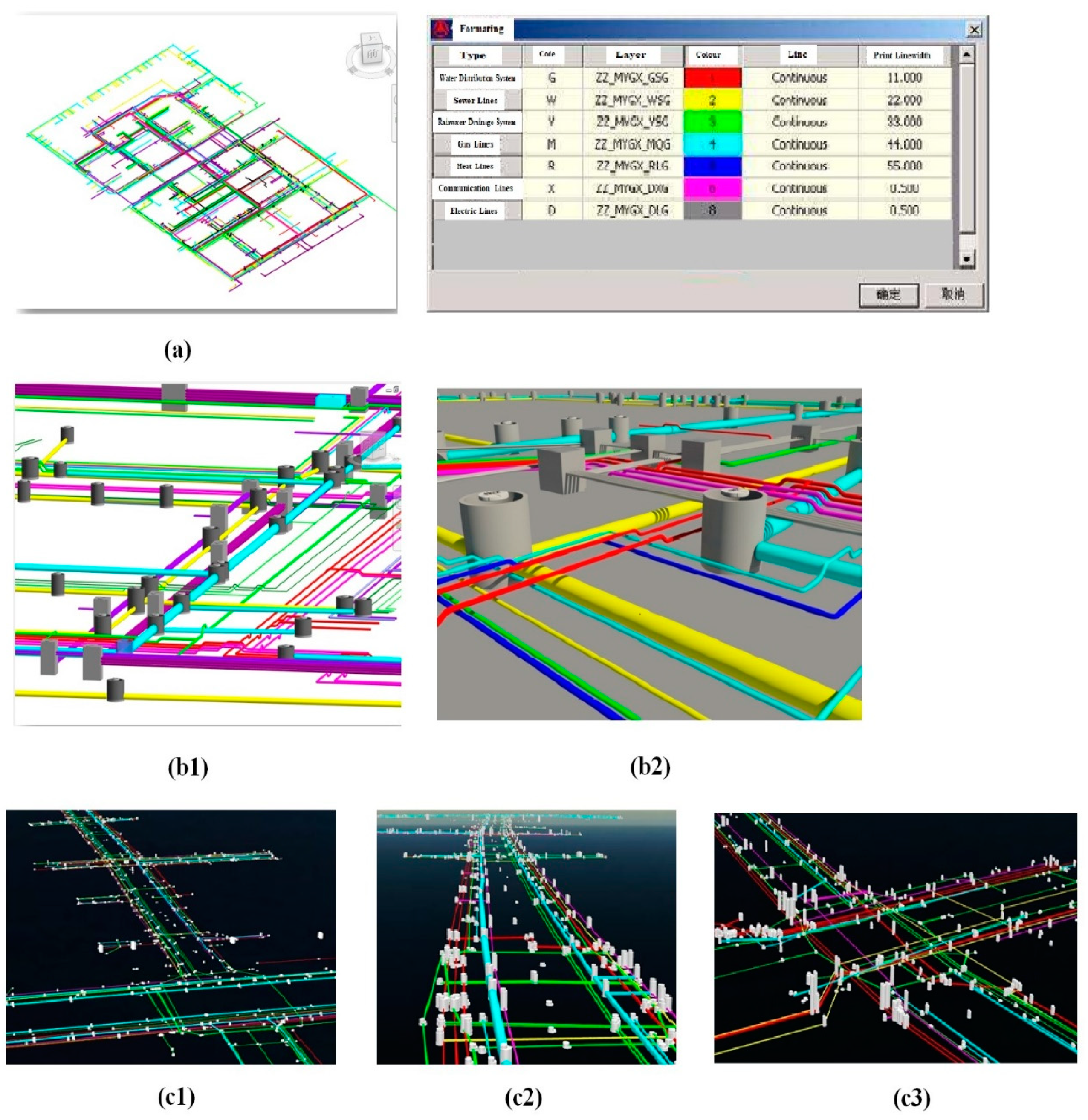
4.1. The Integration of BIM and GIS
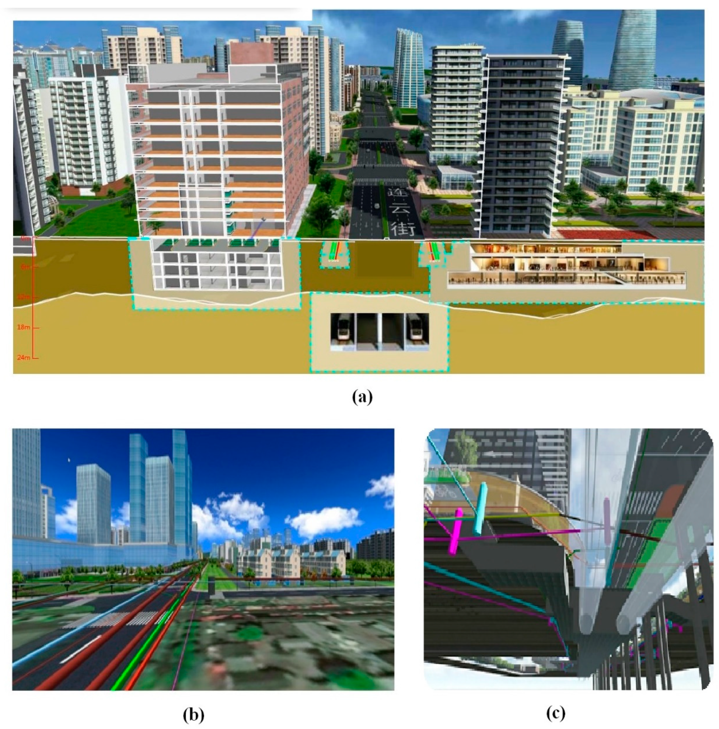
4.2. 3D Visualization Model
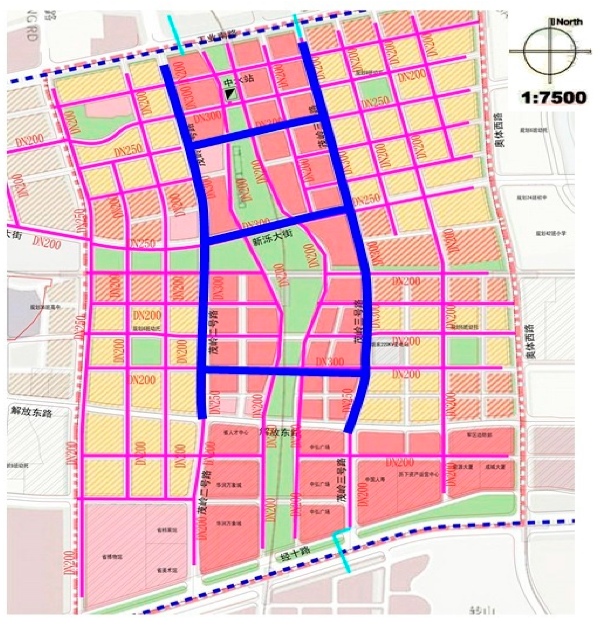
4.3. Establishment of Topological Rules and Topological Analysis for the Proposed WDS Project
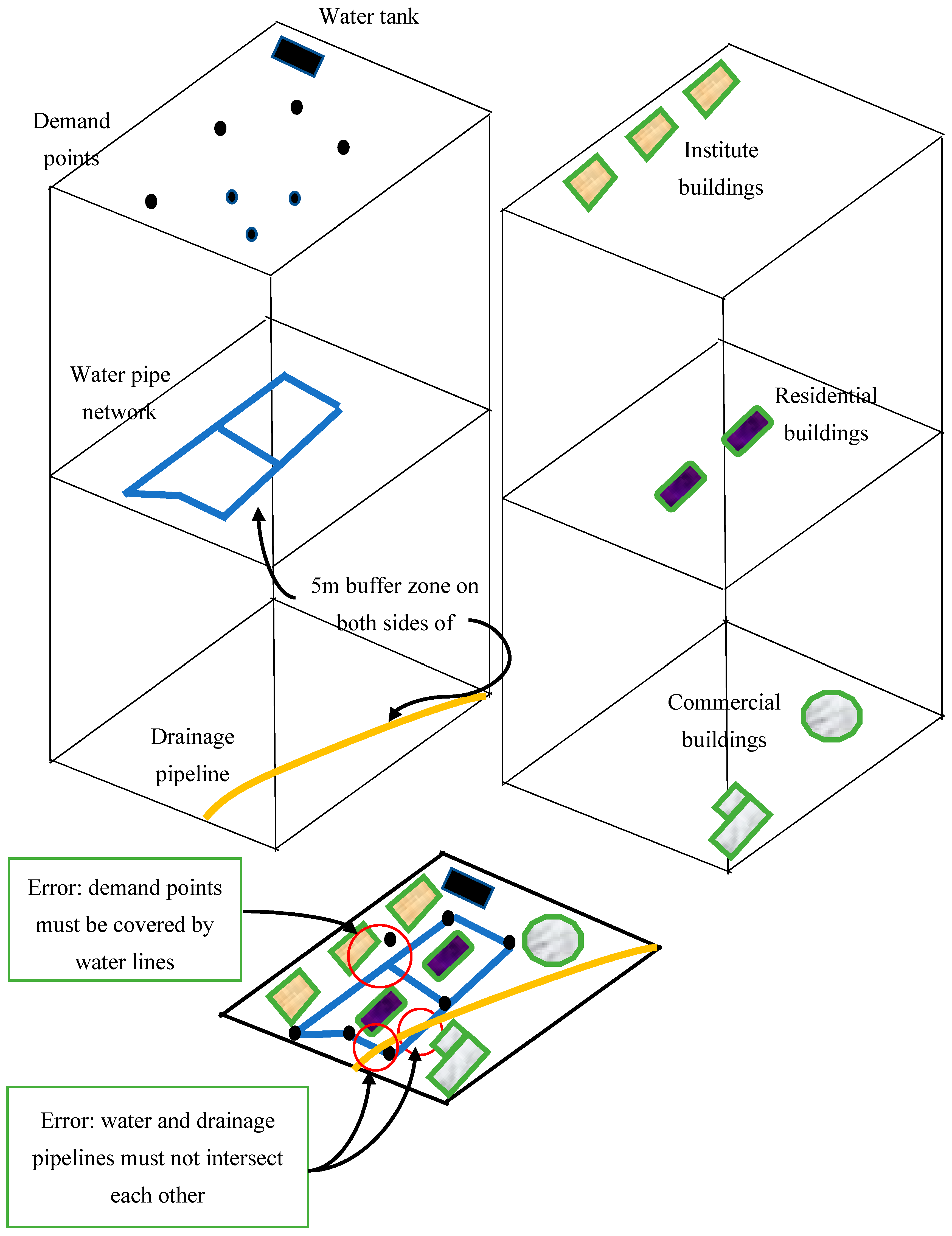
- Set PLAs and topological rules.PLAs must be produced to examine spatial relationships. Moreover, the topological constraints and rules should specify the spatial relationships between the PLAs. All the PLAs must be organized in the same coordinates.
- Decide cluster tolerance.The topology tool can assign a default cluster tolerance that is a minimum possible value based on the precision requirement of a dataset. The cluster tolerance value should be at least an order of magnitude smaller than the precision of a feature dataset so that close vertices are snapped together.
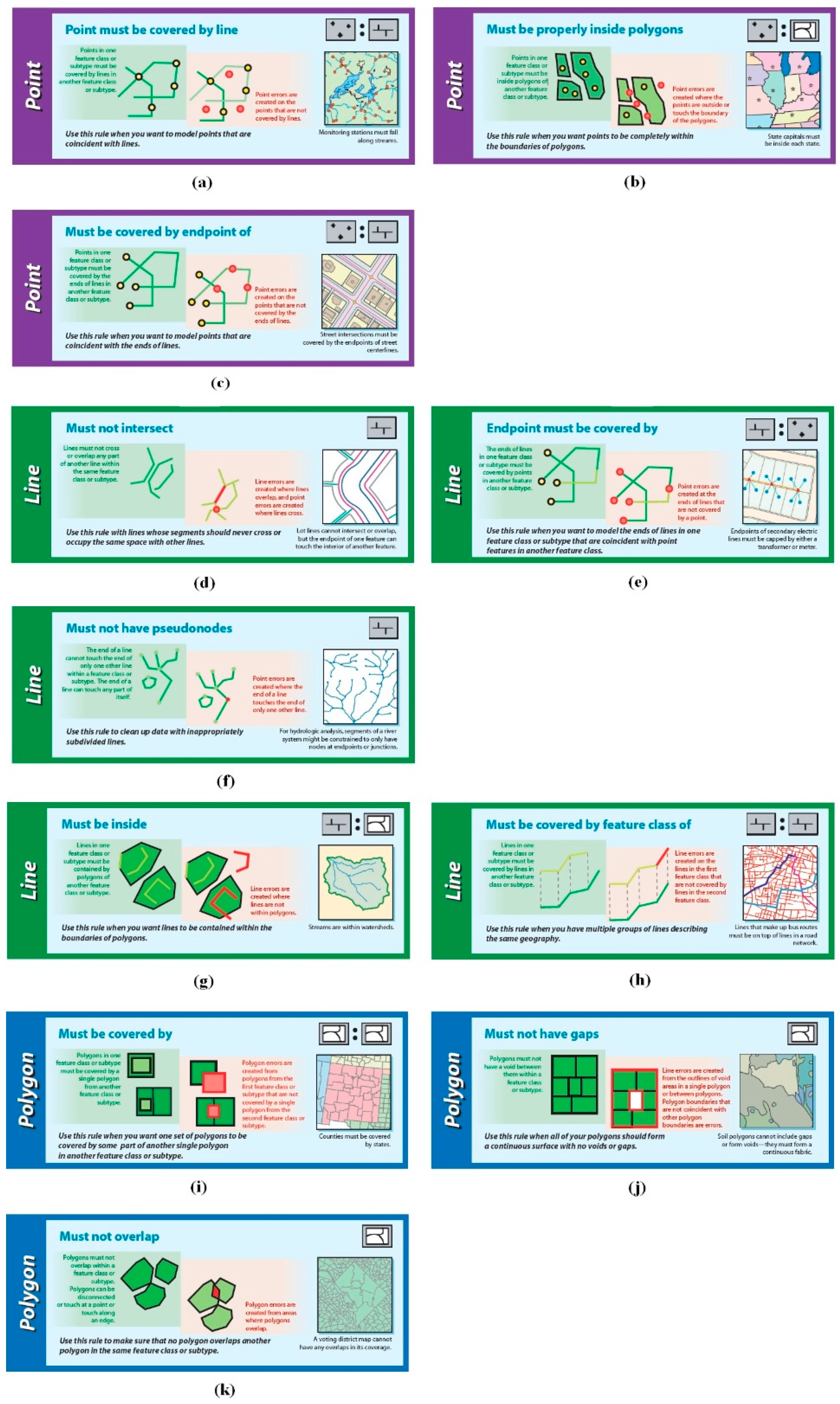
- Assign topological rules.Topological rules are set to govern the spatial relationships among PLAs [27]. PLAs in the studied area are topologically related. Points and lines are constrained, fall inside, are on the edge, or do not cross the edge of a given area. All participating PLAs in the defined area are to be examined. For example, when the “must not overlap” rule is applied to the defined and adjacent areas, the topology tool would examine the overlap between them. All the topological rules used in this study are displayed in Table 1 and the topological rules used in GIS are shown in Figure 14.
- Topology validation.During the validation process, the topological rules are checked against the PLAs to identify any violations so that the PLAs adhere to the defined rules.
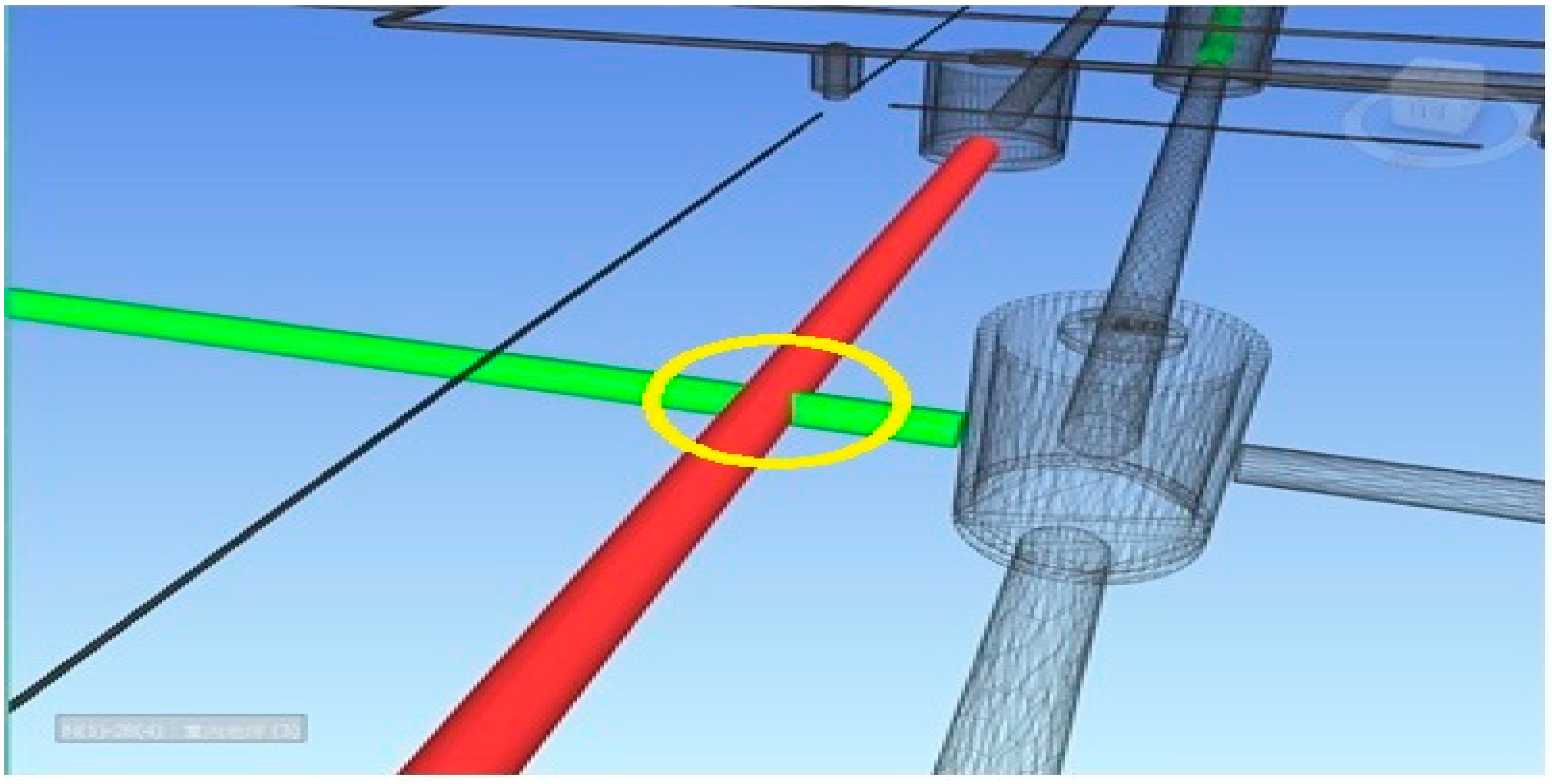
- Error identification.After the validation process, the places where topological rules are violated are identified and marked as dirty areas (red circle areas), which are stored in the topology tool [27]. The topology tool reports the errors so that the user is aware of the violations. In this way, the topology tool helps users to oversee the spatial relationships between the PLAs and the suitability of the pipe network planning.
- Topology editing and revalidationSeveral topology editing tools are provided in ArcGIS to fix the identified topological errors. After editing, the changes are saved in topology and topological rules are required to be revalidated. ArcGIS can automatically identify error locations (these locations violate the topological rules) and only the error locations are revalidated. If the topological rules are changed, the PLAs need to be revalidated.
5. Conclusions
- (1)
- Semantic mapping was used to develop an integrated BIM and GIS model for facilitating the WDS planning process.
- (2)
- The proposed method developed a virtual 3D model of the WDS project and its surroundings using the merits of both BIM and GIS. The virtual 3D model has distinct advantages over 2D drawings.
- (3)
- The proposed method was successfully applied to an actual WDS project. It helped to develop reliable WDS planning without conflicts. In addition, the developed model informs industry professionals where adjustments are required to solve the scarcity of space on site.
- (4)
- The techniques explored in this study also support urban development-related projects where project information models do not exist. The information in this study can enrich 3D city models, extending their usability and functionality.
Author Contributions
Funding
Acknowledgments
Conflicts of Interest
References
- Sun, Z.; Wang, P.; Vuran, M.C.; Al-Rodhaan, M.A.; Al-Dhelaan, A.M.; Akyildiz, I.F. MISE-PIPE: Magnetic induction-based wireless sensor networks for underground pipeline monitoring. Ad Hoc Netw. 2011, 9, 218–227. [Google Scholar] [CrossRef]
- Mancuso, A.; Compare, M.; Salo, A.; Zio, E.; Laakso, T. Risk-based optimization of pipe inspections in large underground networks with imprecise information. Reliab. Eng. Syst. Saf. 2016, 152, 228–238. [Google Scholar] [CrossRef]
- Laucelli, D.; Giustolisi, O. Vulnerability assessment of water distribution networks under seismic actions. J. Water Resour. Plan. Manag. 2015, 141, 1–14. [Google Scholar] [CrossRef]
- Ayad, A.; Awad, H.; Yassin, A. Integrated approach for the optimal design of pipeline networks. Alex. Eng. J. 2018, 57, 87–96. [Google Scholar] [CrossRef]
- Peckienė, A.; Ustinovičius, L. Possibilities for Building Spatial Planning Using BIM Methodology. Procedia Eng. 2017, 172, 851–858. [Google Scholar] [CrossRef]
- Uggla, G.; Horemuz, M. Geographic capabilities and limitations of Industry Foundation Classes. Autom. Constr. 2018, 96, 554–566. [Google Scholar] [CrossRef]
- Kang, T.W.; Hong, C.H. IFC-CityGML LOD mapping automation using multiprocessing-based screen-buffer scanning including mapping rule. KSCE J. Civ. Eng. 2018, 22, 373–383. [Google Scholar] [CrossRef]
- Schevers, H.; Mitchell, J.; Akhurst, P.; Marchant, D.; Bull, S.; McDonald, K.; Drogemuller, R.; Linning, C. Towards digital facility modelling for sydney opera house using IFC and semantic web technology. J. Inf. Technol. Constr. 2007, 12, 347–362. [Google Scholar]
- Bansal, V.K. Use of GIS and topology in the identification and resolution of space conflicts. J. Comput. Civ. Eng. 2011, 25, 159–171. [Google Scholar] [CrossRef]
- Borrmann, A.; Schraufstetter, S.; Rank, E. Implementing metric operators of a spatial query language for 3D building models: Octree and B-rep approaches. J. Comput. Civ. Eng. 2009, 23, 34–46. [Google Scholar] [CrossRef]
- Benner, J.; Geiger, A.; Leinemann, K. Flexible generation of semantic 3D building models. In Proceedings of the 1st International Workshop on Next Generation 3D City Models, Bonn, Germany, 21 June 2005; pp. 17–22. [Google Scholar]
- Isikdag, U.; Underwood, J.; Aouad, G. An investigation into the applicability of building information models in geospatial environment in support of site selection and fire response management processes. Adv. Eng. Inform. 2008, 22, 504–519. [Google Scholar] [CrossRef]
- Van Berlo, L.; Laat, R. Integration of BIM and GIS: The development of the CityGML GeoBIM extension. In Proceedings of the 5th International 3D GeoInfo Conference, Berlin, Germany, 3–4 November 2010. [Google Scholar]
- Tashakkori, H.; Rajabifard, A.; Kalantar, M. A new 3D indoor outdoor GIS model for indoor emergency response facilitation. Build. Environ. 2015, 89, 170–182. [Google Scholar] [CrossRef]
- Deng, Y.; Cheng, J.C.P.; Anumba, C. A framework for 3D traffic noise mapping using data from BIM and GIS integration. Struct. Infrastruct. Eng. 2016, 12, 1267–1280. [Google Scholar] [CrossRef]
- Hijazi, I.; Ehlers, M.; Zlatanova, S. BIM for Geo-analysis (BIM4GEOA): Set up of 3D information system with open source sofrware and open specification. In Proceedings of the 5th International 3D GeoInfo Conference, Berlin, Germany, 3–4 November 2010. [Google Scholar]
- Teo, T.A.; Cho, K.H. BIM-oriented indoor network model for indoor and outdoor combined route planning. Adv. Eng. Inform. 2016, 30, 268–282. [Google Scholar] [CrossRef]
- Kim, J.I.; Koo, B.; Suh, S.; Suh, W. Integration of BIM and GIS for formal representation of walkability for safe routes to school programs. KSCE J. Civ. Eng. 2016, 20, 1669–1675. [Google Scholar] [CrossRef]
- Hjelseth, E.; Thiis, T.K. Use of BIM and GIS to enable climatic adaptations of buildings. In eWork and eBusiness in Architecture, Engineering and Construction: ECPPM; CRC Press: London, UK, 2008. [Google Scholar]
- Irizarry, J.; Karan, E.P.; Jalaei, F. Integrating BIM and GIS to improve the visual monitoring of construction supply chain management. Autom. Constr. 2013, 31, 241–254. [Google Scholar] [CrossRef]
- Sergi, D.M.; Li, J. Applications of GIS-Enhanced Networks of Engineering Information. Appl. Mech. Mater. 2014, 444–445, 1672–1679. [Google Scholar] [CrossRef]
- Giudice, M.D.; Osello, A.; Patti, E. BIM and GIS for district modeling. In Proceedings of the European Conference on Product & Process Modelling, Vienna, Austria, 17–19 September 2014. [Google Scholar]
- Amirebrahimi, S.; Rajabifard, A.; Mendis, P.; Ngo, T. A framework for a micro-scale flood damage assessment and visualization for a building using BIM-GIS integration. Int. J. Digit. Earth 2015, 9, 363–386. [Google Scholar] [CrossRef]
- Christodoulou, S.E.; Ellinas, G. Pipe routing through ant colony optimization. J. Infrastruct. Syst. 2010, 16, 149–159. [Google Scholar] [CrossRef]
- Oliker, N.; Ostfeld, A. Multi-objective optimization of cost and resilience of water distribution system design. In Proceedings of the 2013 World Environmental and Water Resources Congress, Cincinnati, OH, USA, 19–23 May 2013. [Google Scholar]
- Arango, I.M.; Sebastián, J.I.; García, R.P.; Rodríguez, J.B.M. Water distribution system design using agent swarm optimization. In Proceedings of the 12th Annual Conference on Water Distribution Systems Analysis (WDSA), Tucson, AZ, USA, 12–15 September 2010. [Google Scholar]
- Kang, D.; Lansey, K. Revisiting optimal water-distribution system design: Issues and a heuristic hierarchical approach. J. Water Resour. Plan. Manag. 2012, 138, 208–217. [Google Scholar] [CrossRef]
- Misterly, G.; Ellenberger, C.; Voorhees, R.; Jardell, J. Overcoming the challenges of pipeline conflicts on a major interstate P3. In Proceedings of the 2017 Pipelines, Phoenix, AZ, USA, 6–9 August 2017. [Google Scholar]
- Warriner, M.R.; Bartley, Y.E. Pipeline construction management—pitfalls, contract traps, and conflicts: How to recognize and avoid them. In Proceedings of the 2006 Pipeline Division Specialty Conference, Chicago, IL, USA, 30 July–2 August 2006. [Google Scholar]
- Bartolín, H.; Martínez, F.; Cortés, J.A. Bringing up to date WDS models by querying an EPANET-based GIS geodatabase. In Proceedings of the 8th Annual Water Distribution Systems Analysis Symposium, Cincinnati, OH, USA, 27–30 August 2006. [Google Scholar]
- Ardeshir, A.; Saraye, M.; Sabour, F.; Behzadian, K. Leakage management for water distribution system in GIS environment. In Proceedings of the 2006 World Environmental and Water Resource Congress, Omaha, NE, USA, 21–25 May 2006. [Google Scholar]
- Liu, H.; Allouche, E.; Baumert, M. A GIS based simulation of ground movement due to pipe bursting operation. In Proceedings of the International Conference on Pipeline Engineering and Construction, Boston, MA, USA, 8–11 July 2007. [Google Scholar]
- Tao, T.; Xin, K.; Liu, S.; Zhang, X. A pipe network skeleton method based on GIS network analysis technologies. In Proceedings of the International Conference on Pipelines and Trenchless Technology (ICPTT), Shanghai, China, 19–21 October 2009. [Google Scholar]
- Yan, B.; Su, X.R.; Chen, Y.Y. Functional structure and data management of urban water supply network based on GIS. Water Resour. Manag. 2009, 23, 2633–2653. [Google Scholar] [CrossRef]
- Sitzenfrei, R.; Möderl, M.; Rauch, W. WDS designer—A tool algorithmic generation of water distribution systems based on GIS data. In Proceedings of the 2010 World Environmental and Water Resources Congress, Providence, RI, USA, 16–20 May 2010. [Google Scholar]
- Ho, C.I.; Lin, M.D.; Lo, S.L. Use of a GIS-based hybrid artificial neural network to prioritize the order of pipe replacement in a water distribution network. Environ. Monit. Assess. 2010, 166, 177–189. [Google Scholar] [CrossRef] [PubMed]
- Tabesh, M.; Delavar, M.R.; Delkhah, A. Use of geospatial information system based tool for renovation and rehabilitation of water distribution systems. Int. J. Environ. Sci. Technol. 2010, 7, 47–58. [Google Scholar] [CrossRef]
- Tabesh, M.; Saber, H. A prioritization model for rehabilitation of water distribution networks using GIS. Water Resour. Manag. 2012, 26, 225–241. [Google Scholar] [CrossRef]
- Salah, A.M.; Atwood, D. Pipeline alignment optimization: Automated GIS-based approach. J. Pipeline Syst. Eng. Pract. 2011, 2, 2–13. [Google Scholar] [CrossRef]
- Liu, R.; Issa, R.R.A. 3D visualization of sub-surface pipelines in connection with the building utilities: Integrating GIS and BIM for facility management. Comput. Civ. Eng. 2012, 341–348. [Google Scholar]
- Isikdag, U.; Zlatanova, S. Towards defining a framework for automatic generation of buildings in CityGML using BIM. In 3D Geo-information Sciences; Lee, J., Zlatanova, S., Eds.; Springer: Berlin, Germany, 2009. [Google Scholar]
- Building Smart Alliance. IFC for GIS; Building Smart Alliance: Hertfordshire, UK, 2011. [Google Scholar]
- Hallberg, D.; Tarandi, V. On the use of 4D BIM in LMS for Construction Works. J. Inf. Technol. Constr. 2009, 16, 445–466. [Google Scholar]
- de Laat, R.; van Berlo, L. Integration of BIM and GIS: The development of the CityGML GeoBIM extension. In Advances in 3D Geo-Information Sciences; Kolbe, T.H., Konig, G., Nagel, C., Eds.; Springer: Berlin, Germany, 2011. [Google Scholar]
- Becker, T.; Nagel, C.; Kolbe, T.H. Integrated 3D modeling of multi-utility networks and their interdependencies for critical infrastructure analysis. In Advances in 3D Geo-Information Sciences; Kolbe, T.H., König, G., Nagel, C., Eds.; Springer: Berlin, Germany, 2011. [Google Scholar]
- Bedford, M. GIS for Water Management in Europe; ESRI Press: Redlands, CA, USA, 2004. [Google Scholar]
- ESRI. ArcGIS Water Utility Data Model; Environmental Systems Research Institute: Redlands, CA, USA, 2003. [Google Scholar]
- ESRI. GIS Technology for Water, Wastewater, and Storm Water Utilities; Environmental Systems Research Institute: Redlands, CA, USA, 2007. [Google Scholar]
- Grise, S.; Idolyantes, E.; Brinton, E.; Booth, B.; Zeiler, M. Water Utilities. ArcGIS™ Data Models; Environmental Systems Research Institute: Redlands, CA, USA, 2001. [Google Scholar]
- Hwang, H.; Lansey, K. Water distribution system classification using system characteristics and graph-theory metrics. J. Water Resour. Plan. Manag. 2017, 143, 1–13. [Google Scholar] [CrossRef]
- Torres, J.M.; Duenas-Osorio, L.; Li, Q.; Yazdani, A. Exploring topological effects on water distribution system performance using graph theory and statistical models. J. Water Resour. Plan. Manag. 2016, 143, 04016068. [Google Scholar] [CrossRef]


| PLAs | Rules | Use in Pipeline | |
|---|---|---|---|
| Points | a | Must be covered by line | Demand points must be covered pipelines |
| b | Must be properly inside areas | All distribution points must be inside the area | |
| c | Must be covered by endpoint of | Water tank must be covered by end points of the pipeline | |
| Lines | d | Must not intersect | Pipelines must not intersect with each other (water and sewer) |
| e | Endpoints must be covered by | Pipelines in area must end at points | |
| f | Must not have pseudonodes | Pipes can only end at points to prevent subdivided lines | |
| g | Must be inside | The pipes must be inside the area | |
| h | Must be covered by features class of | Underground pipelines must be covered by roads | |
| Areas | i | Must be covered by | Residential buildings to be covered by some part of pipe system area |
| j | Must not have gaps | Land usage of the studied area must form a continuous surface with no gaps | |
| k | Must not overlap | Footprints of various buildings must not overlap |
© 2019 by the authors. Licensee MDPI, Basel, Switzerland. This article is an open access article distributed under the terms and conditions of the Creative Commons Attribution (CC BY) license (http://creativecommons.org/licenses/by/4.0/).
Share and Cite
Zhao, L.; Liu, Z.; Mbachu, J. An Integrated BIM–GIS Method for Planning of Water Distribution System. ISPRS Int. J. Geo-Inf. 2019, 8, 331. https://doi.org/10.3390/ijgi8080331
Zhao L, Liu Z, Mbachu J. An Integrated BIM–GIS Method for Planning of Water Distribution System. ISPRS International Journal of Geo-Information. 2019; 8(8):331. https://doi.org/10.3390/ijgi8080331
Chicago/Turabian StyleZhao, Linlin, Zhansheng Liu, and Jasper Mbachu. 2019. "An Integrated BIM–GIS Method for Planning of Water Distribution System" ISPRS International Journal of Geo-Information 8, no. 8: 331. https://doi.org/10.3390/ijgi8080331