Abstract
Geospatial thinking is essential to the visualization–interpretation processes of three-dimensional geographic information. The design of strategies for the interpretation of the Earth’s surface which allow the development of students’ geospatial thinking poses a challenge in higher education. In geospatial education, we often see a practical approach where students are trained in specific GIS and/or geotechnologies. However, in the first stages of geospatial education, geographic literacy and geospatial thinking processes can be supported better through easy-to-use technologies. In this paper we show the results of two workshops performed with engineering students using visuospatial displays in an easy-to-use 3D software environment. This teaching approach improved students’ geospatial thinking, measured using the Topographic Map Assessment (TMA) test—a battery of seven tasks related to relief interpretation along with 18 exercises. Participants also completed a questionnaire relating to the following usability topics: operation (application), improvement, implications for education, and understanding of the concepts related to relief interpretation. The results showed mean gains between 10.7% and 12.6% of the highest score for the TMA. This, together with the results of the questionnaire, confirms the usefulness of this teaching approach using easy-to-use 3D technologies for developing geospatial thinking.
1. Introduction
For the characterization of landforms (ridges, valleys, hills, etc.), traditional cartographic representations in 2D, in the form of topographic maps at different scales or aerial photographs, are used. Recognition of the topographic surface is necessary to establish a classification of landforms. Through these landforms, spatio-temporal analysis, environmental impact studies, studies of erosion processes, and predictions and simulations in landscape planning, among other things, are carried out [1,2,3]. The potential of visuospatial displays using georeferenced information processing applications (Geographical Information Systems, Spatial Data Infrastructures, and Virtual Globes) facilitates the geovisualization of terrain shapes in three dimensions. These applications use different displays, such as Digital Elevation Models (DEM), image LiDAR (Light Detection and Ranging), Slope Maps, and Hillshades, to name the most commonly used ones. The 3D representations constitute an appropriate source of topographic analysis and geovisualization in geomorphology research on the tasks related to the evaluation of relief and the classification of landforms. In the process of the identification and classification of landforms, the accuracy of the derived landscape map will depend on the subjective skills of the surveyor/analyst [4], although there are automated unsupervised classification techniques, such as the geomorphons approach [5]. This approach is based on the creation of a variety of possible types of morphological landscape generated using the elevation differences of a given environment, although there are more approaches to address the recognition of landforms. On landform classification methods, there are interesting works like that by Kramm et al. [6] in which they compare different approaches. There are specific applications in the field of automated geospatial analytics such as the Grasshopper’s Bison plugin [7] which features tools for terrain mesh creation, analysis, editing, and annotation. 3D modeling and terrain analysis software products such as Rhino [8], Vue [9], Terragen [10], Maya [11], 3dsMax [12], and World Machine [13] are used in landscape architecture curricula for building, rendering, and animating realistic natural environments.
Even though landform representations are relevant in this paper, the present research is not specifically focused on the recognition of landforms. The aim is to initiate the students in the 3D modeling of basic forms of terrain and to verify the impact on the improvement of geospatial thinking. For this, a geovisualization environment based on easy-to-use 3D modeling technologies was used. The term “easy-to-use” is used in this paper according to the answer given by the students about the 3D technologies used in the 3D modeling questionnaire performed in the present research. The geovisual software environment of representation and 3D visualization was defined by Ehlers [14] as “virtual and three-dimensional (3D) representations of the Earth that are spatially referenced and interconnected with digital knowledge archives from around the planet with vast amounts of scientific, natural, and cultural information to describe and understand the Earth, its systems, and human activities”. Findings in cognitive studies of geovisualization can have a great role in improving the usability and utility of geotechnologies and 3D geovisual software environments. In this sense, the growth of geotechnologies in education can produce greater knowledge and awareness of earth sciences in society. With the aim of teaching, Zhu, Pan, and Gao [15] argued that the improvement of geospatial technologies provides an opportunity in geovisualization education. It is necessary, therefore, to design training strategies for interpretation processes, geovisualization, geospatial characterization, and 3D landscape modeling that allow the improvement of geospatial skills, which are needed in working with georeferenced 3D information. This approach concurs with Foresman et al. [16], who highlighted a challenge in the evolution of the digital Earth environment: work on the improvement of skills and abilities in order to influence the next generation.
Findings in cognitive studies of geovisualization and the improvement of spatial skills can have a great role in improving the usability and utility of geotechnologies and 3D geovisual software environments. There is research [17,18] in the field of geovisualization that studied the improvement of geospatial thinking with 3D landforms, in which students had their first contact with landforms. In this research, digital technologies (Augmented Reality) and tangible models (digital terrain models printed in 3D) were used for tasks based on the interpretation of basic landforms. These studies worked with the interpretation of the cartographic relief, but the present research proposes a different approach: the generation of basic landforms using easy-to-use 3D modeling tools.
In the research performed in the present work, the results of two workshops carried out in 2017–2018 (Sketch Up Workshop) and 2016–2017 (Autodesk Workshop) courses, with engineering degree students, on the subject of Topography and Cartography at the University of La Laguna are presented. The impact of the two workshops on the geospatial thinking skill was measured using the Topographic Map Assessment test. The result of a questionnaire is also shown, in which the participants answered questions related to four usability topics: operation of the application, improvement, understanding of concepts related to relief interpretation and representation, and implications for the teaching learning environment.
2. Geovisualization Training
Spatial thinking is the ability to visualize and solve problems spatially [19]. It includes the understanding of spatial information, the methods to represent geospatial information and the processes of spatial reasoning, according to the National Research Council (NRC) report, “Learning to Think Spatially” [20]. The complete definition of the concept according to the NRC is “thinking that finds meaning in the shape, size, orientation, location, direction or trajectory of objects, processes or phenomena, or the relative positions in space of multiple objects, processes or phenomena. Spatial thinking uses the properties of space as a vehicle for structuring problems, for finding answers, and for expressing solutions”. This report has highlighted that map-reading and geotechnologies can support the process of geographical literacy and the improvement of spatial thinking. Spatial thinking is essential for success in university studies related to the STEM (Scientific, Technic, Engineering, and Mathematics) domain [21,22,23,24,25,26]. Institutions, such as the National Science Foundation (NSF), the United States Geological Survey (USGS), the National Aeronautics and Space Administration (NASA), and the National Geographic Survey (NGS), have identified spatial thinking as a crucial competence.
A subset of spatial thinking is the geospatial thinking concept. Authors such as Huynh and Shape [27] defined geospatial thinking as a subset of spatial thinking in the context of the Earth’s surface and its representations. These representations can be traditional maps or digital versions of representation of the terrestrial surface in 2 and 3 dimensions. Geospatial thinking is therefore needed when using visuospatial displays geotechnologies such as GIS or Virtual Globes, to name the most common ones. Geospatial thinking is therefore aimed at the part of spatial thinking related to the ability to visualize and solve problems using maps, cartographies, and geospatial information. Students have difficulties in interpreting the cartographic relief, which limits the improvement of their geospatial thinking. These difficulties can cause problems of frustration among students who are pursuing careers in which the use of geospatial information is frequent, such as geographers, engineers, and/or architects, to name a few [28]. Carbonell, Jaeger, and Shipley [28] showed that the use of 3D rendering and geovisualization technologies is effective, along with the use of traditional 2D maps with contour lines, in increasing student motivation in tasks related to the interpretation of landforms. The procedures for acquiring geospatial thinking through different forms of 2D and 3D representation are therefore still an active field of research addressed in recent works carried out by Carbonell [28], Collins [29], and Eynard and Bernhard [30], among others.
3D spatial representation technologies could enable 21st century engineering students to improve geospatial thinking, which is necessary for the decision-making process in various fields, such as environmental protection, the improvement of social conditions, and to support future sustainable development. In the Beijing Declaration on the Digital Earth [31], special emphasis was placed on the understanding of the Earth as a unit as well as its relevant phenomena. There was a consensus that the Digital Earth has to be promoted by the educational community [32] through “adequate investment and strong support in scientific research and development, education and training”.
Authors such as Foresman et al. [16] have highlighted the particularity of geovisualization education, which shares some aspects included in the curricula of related disciplines, such as training in GIS, SDI, or remote sensing. In this sense, Kerski [33] claimed that “one of the best ways to teach students about the Earth may be through the same tools with which the Earth is modeled, via Geotechnologies”.
Within this framework of action, a new approach is necessary, given the great potential of the visuospatial displays used in geovisual software environments, which must be transferred to teaching areas. This author emphasizes that geovisualization training can be improved through integrative processes of the classical formation of geotechnologies (GIS, SDI, remote sensing, etc.) in an evolutionary environment that excludes classical themes and is more focused on the challenges of the next generation. All this complements the methodologies that are based, among other factors, on spatial enablement and model analysis, such as the strategy developed in the present research. Because geovisualization is integrated into several different disciplines, the best approach to geovisualization education is not through a single particular discipline, but rather through an interdisciplinary approach [33]. In geospatial education, we often see a practical approach where students are trained in GIS, which is a very powerful tool for the teaching and treatment of geospatial information and decision-making. However, it would involve a great effort on the part of the teaching community, who would need specific training in the field of desktop GIS. In turn, great effort is needed to provide specific software for the classrooms [19]. Taking into account these difficulties posed by technologies such as GIS for the first formative stages in geospatial training, it is possible to consider the use of low-cost geospatial technologies that are better supported. A similar approach, with the objective of training that develops spatial skills, was employed by Manson et al. [34], who affirmed that GIS requires more time to learn the numerous commands of the application, neglecting the improvement of geospatial thinking. In this sense, research carried out for the improvement of spatial planning with low-cost and easy-to-implement digital geotechnologies has obtained good results [17,18]. Thus, in the present research, students performed the 3D design of elementary landforms using the proposed low-cost applications that are easy to use and implement, such as Sketch Up and Autodesk 123D Make applications.
Geospatial Thinking and Landforms
Geospatial thinking requires the knowledge, understanding, and analysis of geospatial concepts [27]. In the European educational context, where the present research was performed, there are competences and learning results related to geospatial thinking. Landscape analysis, knowledge of mapping procedures, cartographic representations, mastering the cartographic technique in linear and areal measures and the applications of contour lines, geovisualization, knowledge of the Earth´s processes and landforms, and knowledge of different techniques of relief representation are highlighted [35,36].
The recognition and characterization of landforms is necessary for landscape evaluation [4]. Learning in geomorphology is part of geographic and engineering education. Training in geomorphology allows students to understand the processes involved in the formation of landforms [37]. However, the learning of the geomorphological processes is complex for students, partly because they lack basic knowledge, and partly because of the difficulty that students have with cartographic interpretation [38,39,40]. Therefore, in a first contact of the students with tasks related to the visualization and interpretation of the landforms, it is necessary to familiarize students with the elementary landforms such as plains, elevations, depressions, ridges, valleys, hills, and cols (also called mountain passes or saddle points) through easy-to-use technological tools that facilitate their first understanding. This basic knowledge also aids in the improvement of geographic literacy, a term defined by the United Nations [41,42] as “the competence of individuals to recognize geographic space, as well as the ability to understand, process, and utilize the basic skills of geography”. Since 2010, the use of geovisualization tools in an electronic environment has been proposed to measure geographic literacy [43].
3. Material and Methods
3.1. Participants
In the two workshops, undergraduate engineering degree students from the University of La Laguna participated in the subject of Topography and Cartography. The Sketch Up workshop was performed with 24 students (10 female, 14 male, with a mean age of 21.04 and standard deviation of 1.20). In the Autodesk workshop, 24 students (5 female, 19 male, with a mean age of 21.00 and standard deviation of 1.01) participated. These were two groups of different students, each one from a different academic year. Those from the Autodesk Workshop belonged to the 2016–2017 course, and those from the Sketch Up Workshop, to the 2017–2018 academic year. Six groups of four members were formed for each of the workshops. Both activities were voluntary, and students could leave at any time. Participants had no previous experience using Sketch Up and/or AutoDesk 123D Make applications in their curriculum. Students participating in the workshops did not have previous exposure to the test that was used in the workshops to measure their geospatial thinking.
In the research developed in the present work, the results of the two workshops carried out in the 2017–2018 (Sketch Up Workshop) and 2016–2017 (Autodesk Workshop) courses with engineering degree students on the subject of Topography and Cartography at the University of La Laguna are presented.
3.2. Hardware and Software
The Sketch Up workshop was carried out with the Sketch Up Make 2017 free application with the Sandbox Tools plugin. The students accessed the application by selecting the Sandbox Tools option within the extensions that are offered in the program preferences. The Autodesk 123D Make free application was used in the Autodesk workshop. These applications are freely available at https://bit.ly/2sXjsDD and https://www.sketchup.com/es/download/all#es, respectively.
For computers with the Windows operating system, the software requirements to install Sketch Up Make are a web browser and a 64-bit version of Windows. Additionally, Windows 8.1 (or higher) had to be updated using Windows Update. Regarding hardware, the minimum requirements were an Internet connection, 1 GHz processor, 4 GB RAM, 16 GB of total hard disk space, 500 MB of free hard disk space, and a 3D-class video card with 512 MB of memory or higher. For Mac computers, the software requirements were QuickTime 5.0 and a web browser. The hardware recommendations were an Internet connection, a 2.1+ GHz Intel™ processor with 8 GB RAM, and 700 MB of available hard disk space. The Autodesk123D Make application only works with 32-bit or 64-bit Windows operating systems. The minimum hardware requirements were an Internet connection, a 2 GHz processor, 512 MB RAM, 1.5 GB of free hard disk space, and a graphics card with a minimum of 64 MB of memory.
Participants used their own computers to perform the activity, in accordance with the Bring Your Own Device (BYOD) trend of the higher education Edition Horizon report [44]. This report, from the New Media Consortium, represents a reference for university education and identifies trends and technologies to be used in higher education. The BYOD trend promotes the use by students of their own devices, such as computers, tablets, or smartphones, in class. Before beginning the workshops, it was found that the laptops of the students met these minimum requirements. In the event that a participant did not have a computer or that the latter did not fulfil these minimum requirements, the instructor provided a computer for the activity. These requirements, in principle, can be a limitation, although in practice it became clear that all computers complied with them. Neither application had specific software and hardware requirements that were too demanding; therefore, they pose no limitation for their implementation in teaching environments.
3.3. Procedure
The schedule of the two workshops was developed in five phases: Phase 1, specific training on landforms (1 h); Phase 2, completion of the Topographic Map Assessment Pre-test (30 min); Phase 3, installation of Sketch Up Make and/or Autodesk 123D Make applications (30 min); Phase 4, realization of the landforms (3 h for the Sketch Up Make workshop, and 3 + 2 h for the Autodesk 123D Make workshop); Phase 5, completion of the Topographic Map Assessment Post-test (30 min). Phases 1, 2, and 3 were carried out in a two-hour session. The following week, Phases 4 and 5 were carried out in another session of three and a half hours for the Sketch Up Make workshop. For the Autodesk 123D Make workshop, two sessions for Phases 4 and 5 were needed: three hours in one day for Phase 4, then two and a half hours to complete Phase 4 and a post test (Phase 5) the next day. There were two teachers assigned to the students for each of the phases.
In both workshops, participants first received specific training on the concepts of landforms and contour lines. Each of the seven elementary landforms with which the participants were going to work in the workshop was defined: plains, elevations, depressions, ridges, valleys, hills, and cols (also called mountain passes or saddle points). These definitions were illustrated with examples visualized in 2D and 3D. The Topography and Cartography subject has specific contents related to the forms of relief. For example, to illustrate the concept of ridges, participants were shown, along with their definition, a representation with contour lines in 2D and 3D and 3D Digital Elevation Model images (Figure 1).
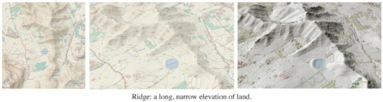
Figure 1.
Example of the definition of a ridge in the specific training phase on landforms. (Left) A contour lines map in 2D. (Center) A contour lines map in 2D. (Right) A Light Detection and Ranging (LiDAR) Digital Elevation Model.
After the training phase on landforms and their representation, students installed the Sketch Up Make 2017 and Autodesk 123D Make applications on their laptops. Once the participants had installed the applications, the instructor invited them to construct the landforms described in the training phase. The task, therefore, was the realization of seven landforms (plains, elevations, depressions, ridges, valleys, hills, and cols) using the Sketch Up workshop and Autodesk workshop. Students were not asked for a piece of land in a specific area: it was about generating generic landforms. Before and after each workshop, participants took the Topographic Map Assessment test and responded to a 3D modeling questionnaire. This research did not try to evaluate the accuracy of terrain between the groups, but to verify which of the two technologies (Sketch Up Maker or Autodesk 123D Make) had a greater effect on the participants’ geospatial thinking. In this way, analyzing the pre-test and post-test results of the Topographic Map Assessment test, it could be checked which technology offers a better result for the improvement of geospatial thinking. In addition, the results of the 3D modeling questionnaire would show the preferences of the students in each of the four analyzed aspects of the technologies used.
In the Sketch Up workshop, the students used the Sandbox Tools plugin. This plugin implements the sandbox concept, which is a surface that can be generated through Sandbox tools. This kind of surface is referred to as a triangular irregular network (TIN) in terrain modeling terminology. Students can build a landform starting from a flat rectangular TIN using the Smoove tool. Another option is to create the 3D model from contour lines (using the “Sandbox From Contours” tool). Additionally, it is possible to import a pre-existing terrain into Sketch Up from CAD files, image files, Digital elevation models (DEM files), STL files (3D printing), 2D studio files, and Google Earth, among other sources.
Participants were asked to submit a compressed file containing the seven landforms using these different options. They were asked to export their models in PDF format (Figure 2). The delivery of the activity was conducted through the virtual classroom of the subject in a tab enabled for this purpose.
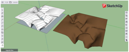
Figure 2.
Depression landform with Sketch Up 123D Make created by students.
In the Autodesk workshop, the participants had different formats of terrain forms in STL format in the virtual classroom of the subject. Through the Stacked Slices manufacturing technique, students generated horizontal sections (templates). These horizontal sections correspond to the concept of a contour line. Afterwards, the templates were printed on paper and pasted on vinyl (EVA rubber), to be cut with a cutter or scissors later. These horizontal sections were pasted successively to obtain the 3D model (Figure 3, right).
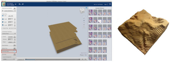
Figure 3.
(Left) Autodesk123 Make interface screen capture. (Right) 3D model created by students.
3.4. Measurement of Geospatial Thinking Improvement
The participants completed the Topographic Map Assessment (TMA) Test [45] before (Pre-test) and after (Post-test) the workshop in order to determine the impact of the activity on their geospatial thinking. The complete test and its instructions can be downloaded from the Spatial Intelligence and Learning Center at http://www.spatiallearning.org/index.php/resources/testsainstruments.
The Topographic Map Assessment Test (TMA) is a test developed by researchers from Temple University (USA) and Northwestern University (USA). The TMA is a battery of seven tasks related to relief interpretation, along with 18 exercises, in which different landforms are presented using different forms of representation: contour lines, three-dimensional representations printed in 2D, perspectives, photos, and terrain profiles. The following are raised in the test questions related to the interpretation of the relief: the inter-visibility between points, water circulation, choice of the route with the least effort, etc. A description of the TMA exercises, associating them with the task performed in each one, is shown in Table 1. The maximum score of the test is 28 points: item 3 is worth 5 points; items 9, 10, 12, and 17 are worth 2 points; item 11 is worth 3 points; and the rest of the items are worth 1 point. The Topographic Map Assessment Test contains an annex on the cartographic representation of the terrain in which there is a detailed description of the contour line concept.

Table 1.
Topographic Map Assessment tasks.
Table 1.
Topographic Map Assessment tasks.
| Task | Description | Item Number |
|---|---|---|
| Path | Easy route between two points | 1 |
| Stream/water flow | Water flow between two points in different geographical settings | 2, 10, 11, 12 |
| Slope | Steeper slope between two points | 5, 9 |
| Visibility | Questions about visibility between points | 3, 17 |
| Elevation points | Questions about elevation points in a contour interval scenario | 4, 6, 7 |
| Photointerpretation relief | Different questions relating to a photograph/image of a topographic map of a land with contour lines | 8, 15, 16, 18 |
| Profile | Questions about topographic profiles from a topographic map with contour lines | 13, 14 |
There are numerous psychometric tests for the measurement of spatial skills, such as, for example, the Mental Rotation Test [46], which measures spatial rotation, or the Perspective Taking Spatial Orientation Test [47], which measures spatial orientation. For the measurement of geospatial thinking, the TMA examines a great variety of parameters related to the topographical representation of the terrain and its interpretation; therefore, it is suitable for this type of research in which work on terrain representations is conducted. The TMA has been used in the subject of Cartography at the University of La Laguna since the 2014–2015 academic year and has been used in other research related to geospatial thinking and the interpretation and visualization of landforms using 2D and 3D technologies [17,18].
At the end of the workshops, the participants answered 12 questions related to four usability topics: operation of the application, improvement, understanding of concepts related to relief interpretation and representation, and implications for the teaching learning environment (Table 3). The answers to the questionnaire were given on a Likert scale (1: strongly disagree; 2: disagree; 3: neither agree nor disagree; 4: agree; 5: totally agree). In the questionnaire, there were three questions (Q1, Q2, and Q3) related to the use of the Sketch Up/Autodesk123D Make application. The Q4, Q5, and Q6 questions were related to the improvement of spatial skills and geographical literacy. Questions Q7, Q8, and Q9 were related to the interpretation of the relief. Finally, in questions Q10, Q11, and Q12, the students were asked about their opinion on the teaching and learning strategies developed.
4. Results
The present research offers measures of the possible improvement of the geospatial thinking skill of the participants, for which the results of the TMA (post-test minus pre-test) are analyzed. Additionally, a survey collected the opinions of the participants in the workshops.
4.1. Geospatial Thinking
For SketchUp workshop data, as a first approach, a multivariate ANOVA (MANOVA) 2 × 2 was carried out (Male vs. Female and Pre-test vs. Post-test) for the seven tasks (summed scores for Path, Stream/Water flow, Slope, Visibility, Elevation Points, Photointerpretation of Relief, Profile, and the Final Score). The assumptions of the General Linear model were fulfilled; in addition, the analysis is robust due to equal sample sizes. In previous research on the improvement of geospatial thinking capacity, the gender component has been studied. For this reason, it is included in the present analysis [36,38]. The effect of gender was not significant (F7,16 = 0.416; p = 0.879; η2 = 0.154), but the Post-test showed significantly higher scores than the Pre-test (F7,16 = 9.416; p = 0.000; η2 = 0.808).
The corresponding posterior Univariate Analysis revealed that the Pre-test had lower scores than the Post-test for Stream/water flow (F1,22 = 16.600; p = 0.001; η2 = 0.399), Slope (F1,22 = 9.462; p = 0.006; η2 = 0.301), Visibility (F1,22 = 12.854; p = 0.002; η2 = 0.369), Elevation Points (F1,22 = 10.857; p = 0.003; η2 = 0.330), Photointerpretation of Relief (F1,22 = 3.697; p = 0.068; η2 = 0.144), and Profile (F1,22 = 17.068; p = 0.000; η2 = 0.437). However, for Path, there was not a significant difference between students (F1,22 = 1.426; p = 0.245; η2 = 0.061).
The Total Score gain (Post-test minus Pre-test) in the SketchUp activity was 3.54 (SD = 2.65) (F1,22 = 39.152; p = 0.000; η2 = 0.640). Bearing in mind the highest possible scores for the tasks, this gain represents 12.6% of the highest possible score. All details for the tasks can be found in Table 2. The mean gain for Stream/Water flow represents 12.5% of the highest possible score. Slope had a gain of 19.3%, Visibility 11.3%, Elevation Points 9.7%, Photointerpretation of Relief 5.3%, and Profile 31.3% of the highest possible score.
Table 2.
Topographic Map Assessment (TMA) means and standard deviations by group (SketchUp and Autodesk123) in the Pre- and Post-tests, along with the gains.
Table 2.
Topographic Map Assessment (TMA) means and standard deviations by group (SketchUp and Autodesk123) in the Pre- and Post-tests, along with the gains.
| SketchUp n = 24 | AutoDesk123 n = 24 | ||||||||
|---|---|---|---|---|---|---|---|---|---|
| Pre | Post | Gain | Gain% | Pre | Post | Gain | Gain% | ||
| Path | Mean | 0.88 | 0.92 | 0.04 | - | 0.92 | 0.83 | −0.08 | |
| SD | 0.34 | 0.28 | 0.20 | 0.28 | 0.38 | 0.41 | |||
| Stream/water flow * | Mean | 3.21 | 4.21 | 1.00 | 12.5 | 3.38 | 4.00 | 0.63 | 7.8 |
| SD | 1.74 | 1.67 | 1.22 | 1.24 | 1.74 | 2.20 | |||
| Slope * | Mean | 1.96 | 2.54 | 0.58 | 19.3 | 1.88 | 2.29 | 0.42 | 13.9 |
| SD | 0.81 | 0.59 | 0.88 | 0.74 | 0.86 | 1.06 | |||
| Visibility * | Mean | 3.75 | 4.54 | 0.79 | 11.3 | 3.92 | 4.67 | 0.75 | 10.7 |
| SD | 1.36 | 1.50 | 1.02 | 1.41 | 1.58 | 1.29 | |||
| Elevation Points * | Mean | 1.67 | 1.96 | 0.29 | 9.7 | 1.67 | 1.96 | 0.29 | 9.7 |
| SD | 0.70 | 0.62 | 0.55 | 0.64 | 0.69 | 0.69 | |||
| Photointerpretation of Relief * | Mean | 1.13 | 1.33 | 0.21 | 5.3 | 0.92 | 1.29 | 0.38 | 9.5 |
| SD | 0.68 | 0.87 | 0.51 | 0.72 | 0.75 | 1.10 | |||
| Profile * | Mean | 0.50 | 1.13 | 0.63 | 31.3 | 0.54 | 1.17 | 0.63 | 31.3 |
| SD | 0.66 | 0.68 | 0.71 | 0.66 | 0.64 | 0.97 | |||
| Total Score * | Mean | 13.08 | 16.63 | 3.54 | 12.6 | 13.21 | 16.21 | 3.00 | 10.7 |
| SD | 3.26 | 3.40 | 2.65 | 2.69 | 3.02 | 3.46 | |||
* Significant gains (Pre < Post) for both groups.
In order to compare the SketchUp workshop with the Autodesk workshop, another MANOVA 2 × 2 was performed (SketchUp vs. Autodesk123 and Pre-test vs. Post-test). The assumptions of the General Linear model were fulfilled; in addition, the analysis is robust due to equal sample sizes. Neither the Interaction (F7,40 = 0.551; p = 0.790; η2 = 0.088) nor the group effects (F7,40 = 0.275; p = 0.960; η2 = 0.046) were significant. Only the multivariate effect of Pre-test vs. Post-test (F7,40 = 8.255; p = 0.000; η2 = 0.519) appeared. Gender was not included in the model due to the non-significant effect obtained in the previous analysis and because the Autodesk workshop had only five females in the group (n = 24).
The corresponding posterior Univariate Analysis revealed that the Pre-test had lower scores than the Post-test for Stream/water flow (F1,46 = 10.009; p = 0.003; η2 = 0.179), Slope (F1,46 = 12.641; p = 0.001; η2 = 0.216), Visibility (F1,46 = 21.005; p = 0.000; η2 = 0.313), Elevation Points (F1,46 = 10.484; p = 0.002; η2 = 0.186), Photointerpretation of Relief (F1,46 = 5.593; p = 0.022; η2 = 0.108), and Profile (F1,46 = 25.940; p = 0.000; η2 = 0.361). For Path, there was not a significant difference between students (F1,46 = 0.200; p = 0.657; η2 = 0.004).
Similar to that in the SketchUp activity, the Total Score gain in the Autodesk activity was 3.00 (SD = 3.46) (F1,46 = 53.937; p = 0.000; η2 = 0.540).
The means and standard deviations of the different tasks (adding corresponding items) in the Pre-test and the Post-test for each group, as well as the total gains and the percentages they represented for each highest possible score, are shown in Table 2. It can be seen that both workshops produced an improvement for all tasks, except for Path. (Pre: Pre-test score, before the workshops; Post: Post-test score, after the workshops; gain: Post-test score minus Pre-test score for each group in each item; gain%: the percentage of the highest possible score).
Regarding the Total Score, the SketchUp workshop participants started with a mean of 13.08 (SD = 3.26) and reached a mean of 16.63 (SD = 3.40). Autodesk participants started at 13.21 (SD = 2.69) and reached 16.21 (SD = 3.02). These are improvements of 12.6 and 10.7% of the highest possible Total Score, respectively. The Total Scores obtained before and after the SketchUp and Autodesk workshops are shown in Figure 4. It can be observed that both groups had higher Total Scores after their workshop (Post-test).
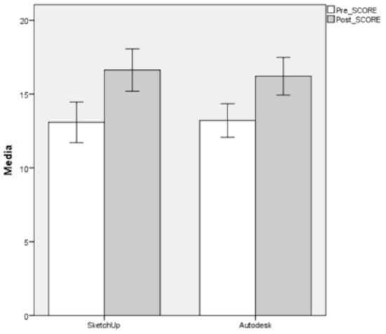
Figure 4.
TMA Total Score for Pre- and Post-tests by group. Bars represent 95% confidence intervals.
The details of gains expressed in percentages for tasks in each workshop are shown in Figure 5. SketchUp and Autodesk had similar gains. The Profile task had the greatest gain (31.3% for both groups), followed by the Slope task (13.9–19.3%). Only for the Path task was there no improvement.
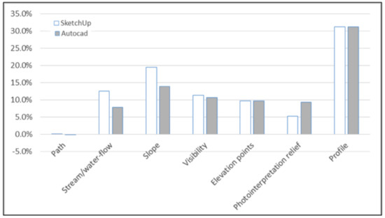
Figure 5.
Gains by group: percentage of the highest possible scores.
4.2. 3D Modeling Questionnaire
First, we assessed the reliability of the questionnaire in each group using Cronbach´s Alpha. The obtained value for a unidimensional model was 0.71 including both groups (n = 56). George and Mallery [48] established the following scale for the Cronbach´s Alpha coefficient: >0.9 excellent; >0.8 good; 0.7 acceptable; 0.6 questionable; and >0.5 poor.
The questionnaire and its results are shown in Table 3. The groups did not differ in their Total Scores (t54 = 1.71; p = 0.093). However, a comparison of the means of Items and the difference in Q8 is remarkable. SketchUp participants have a significantly lower mean than Autodesk participants (t54 = 11.99; p = 0.000).
Table 3.
3D modeling questionnaire results.
Table 3.
3D modeling questionnaire results.
| 3D Modeling Questionnaire Likert Scale (1: Strongly Disagree, 3: Neither Agree nor Desagree, 5: Strongly Agree) | SketchUp Workshop Mean (SD) | Autodesk Workshop Mean (SD) | ||
|---|---|---|---|---|
| Operation of SketchUp/ Autodesk123D Make application | Q1 | SketchUp/Autodesk123D Make is a powerful tool for the 3D modeling of landforms | 4.54 (1.03) | 4.46 (0.92) |
| Q2 | The application SketchUp/Autodesk123D Make is stable, no crashes | 4.11 (1.34) | 4.36 (1.03) | |
| Q3 | 3D modeling of landforms with SketchUp/Autodesk123D Make is easy and intuitive | 3.50 (1.20) | 3.07 (0.90) | |
| Improvement | Q4 | 3D modeling of landforms with SketchUp/Autodesk123D Make helps me with my geographical literacy | 4.18 (0.82) | 3.82 (0.86) |
| Q5 | I think 3D modeling activities of landforms with SketchUp/Autodesk123D Make develops my geospatial thinking | 3.96 (1.26) | 3.82 (1.12) | |
| Q6 | 3D modeling of landforms improves my understanding of relief | 4.00 (1.02) | 4.29 (0.85) | |
| Understanding of the concepts related to relief interpretation and representation | Q7 | I understand the landforms better from 3D modeling activities than from theoretical classes of the representation of relief | 4.00 (1.12) | 4.25 (0.75) |
| Q8 | 3D modeling of landforms helps me understand the concept of contour lines | 1.61 (1.13) | 4.75 (0.80) | |
| Q9 | 3D landform activities complement the traditional techniques of representing topographic relief | 2.11 (1.13) | 2.50 (1.13) | |
| Implications for the teaching–learning environment | Q10 | 3D modeling of landforms complements the traditional cartography teaching | 4.21 (0.79) | 3.89 (1.20) |
| Q11 | In my Digital Earth education, I consider activities with 3D modeling of landforms relevant | 3.89 (1.10) | 4.04 (1.07) | |
| Q12 | SketchUp/Autodesk123D Make is a valid tool for the early stages of Digital Earth education | 3.96 (1.17) | 3.93 (1.30) | |
| Total Score | 44.07 (6.90) | 47.18 (6.70) | ||
(SD) Standard deviation.
5. Discussion and Conclusions
Other studies have been carried out which have measured the impact that technologies such as augmented reality, 3D mesh processing applications, and digital terrain models printed in 3D [17,18] have had on geospatial thinking. These studies worked with the interpretation of the cartographic relief, but this research proposes a different approach: the generation of landforms using 3D design with two visuospatial displays.
The activities related to the generation of landforms carried out in this research had a significant effect on the improvement of geospatial thinking. Both had higher scores after the workshops, with mean gains of 3.54 (SD = 2.65) and 3.00 (SD = 3.46). These gains represent 12.6% and 10.7% of the highest possible score (28). Sketch Up participants started with 13.08 (SD = 3.26) points and ended up with 16.21 (SD = 3.02), and Autodesk workshop participants started with 13.21 (SD = 2.69) and ended up with 16.25 (SD = 3.10). Compare this with previous research: strategies based on the joint use of augmented reality, 3D mesh processing (information represented in a 3D view on a planar surface like a cell phone screen), and 3D digital terrain model (3D printed model) obtained a gain of 4.56 points on the TMA test [18]. In that research there was a control group working with traditional 2D maps, and their gain was 1.55 points on the TMA test. Strategies based on the joint use of augmented reality and traditional 2D maps obtained a gain of 5.41 points on the TMA test [17] (in that case, the gain on the TMA test using only 2D strategies was 2.22 points). The gain obtained in the present research is lower (3.54, SD = 2.65) than that in the previous research just mentioned (though superior to the gains obtained with 2D maps in those previous research). It is necessary to take into consideration that they are two different tasks: the generation of landforms used in this research and the interpretation of landforms used in the other two previous studies.
In relation to gender, the results obtained show that there are no significant differences between men and women regarding the improvement of geospatial thinking after training, which coincides with the results on gender obtained in previous research [36,38].
The gain for each grouped variable in the workshops shows a non-significant effect on either group or interaction; that is to say, the gains for the SketchUp participants do not differ significantly from the gains for Autodesk participants. Nonetheless, it seems that the SketchUp participants tend to have a greater improvement in relation to Stream/water flow, Slope, and Visibility, but a lower improvement in relation to the Photointerpretation of relief. In the case of a larger number of participants and smaller standard deviations, this trend could be significant.
The results of the 3D modeling questionnaire show the feedback of the students who participated in the workshops, measured within a Likert Scale of 5 points. Issues related to the handling of the interfaces of the SketchUp and Autodesk123D Make applications presented similar and high results in the two workshops. The minimum score obtained was 3.07.
In the questions referring to the improvement of geospatial skills, the scores are high in both workshops (above 3.82 points). The students perceived that their participation in the workshops contributed to the improvement of their geographic literacy, their understanding of relief, and their geospatial thinking.
In the section on understanding concepts related to relief interpretation and representation, differences appear between the two workshops; in particular, in question Q8 (3D modeling of landforms helps me understand the concepts of contour lines). In the workshop with SketchUp, the score obtained was low (1.61), but in the Autodesk workshop, it was quite high (4.75). This is because, in the Autodesk workshop, the students worked directly with level curves, since they printed them, cut them out and pasted them together in their correct order to obtain the 3D model. In this section, in addition, the scores obtained in question Q9 (3D landforms activities complement the traditional techniques of the representation of topographic relief) were low (2.11 and 2.50, respectively). This may be due to the fact that students perceive these modes of representation more as tools for teaching–learning processes than for the representation of the terrain, where the 3D representations used by GIS and spatial data infrastructures offer greater potential.
In relation to the issues related to the teaching–learning processes, the scores obtained were high for the two workshops, with values above 3.89 in both cases. Students value positively the implementation of tasks related to the modeling of landforms in formal teaching.
In this paper we show a strategy of first contact with concepts related to basic landforms and provide a teaching approach based on easy-to-use technologies (Sketch Up and Autodesk123D Make) that improve the geospatial thinking of the students. It serves as a first contact with 3D rendering technologies and contributes, in turn, to the necessary geographic literacy in the early stages of Digital Earth education, in accordance with the stipulations of the Beijing Declaration on the Digital Earth [31]. At a more advanced level, there are other advanced applications that aim at digital terrain modeling, such as AR Sandbox [49,50], Rhino [8], Vue [9], Terragen [10], Maya [11], 3dsMax [12], and World Machine [13], which could be used to enrich the learning process. As a future work, it would be interesting to carry out a workshop in which the impact of these advanced technologies on the improvement of participants’ geospatial thinking would be measured (using the same measurement tool used in this research).
On the other hand, the role of 3D GIS methods in teaching learning processes is crucial, although they require a great amount of teacher training. Another proposal to use easy-to-use technologies in the GIS field related to the recognition of landforms could be a workshop based on the geomorphons approach [5] (since it was developed for the open source GIS Software GRASS GIS), measuring its impact on the improvement of geospatial thinking. It would be interesting, in turn, to extend this analysis to these technologies in the field of the improvement of geospatial thinking and establish comparisons with CAD systems and/or with tangible interfaces for landscape analysis such as AR Sandbox [49,50] and Illuminating Clay [51].
Author Contributions
Conceptualization, C.C.-C. and S.H.-M.; methodology, C.C.-C.; software, C.C.-C.; validation, C.C.-C. and S.H.-M.; formal analysis, S.H.-M.; investigation, C.C.-C.; resources, C.C.-C.; data curation, C.C.-C. and S.H.-M.; writing—original draft preparation, C.C.-C.; writing—review and editing, C.C.-C.; visualization, C.C.-C. and S.H.-M.; supervision, C.C.-C.; project administration, C.C.-C.; funding acquisition, C.C.-C.
Funding
This research was funded by the framework of action of the Spanish Ministry of Education, Culture and Sport, within the Framework of the State Program for the Promotion of Talent and its Employability in I+D+i, the State Mobility Subprogram of the State Plan for Scientific and Technical Research and Innovation 2013–2016 (2017 announcement). The University of La Laguna has supported this work: Innovate Educational Project for the academic year 2017/2018 “3D environments for land modelling”.
Acknowledgments
We acknowledge the support given by the Research in Spatial Cognition Lab (https://sites.temple.edu/risc/) of Temple University, who performed the Topographic Map Assessment Test and helped us in the conceptualization of the present research.
Conflicts of Interest
The authors declare no conflict of interest
References
- Pike, R.J.; Park, M. Geomorphometry—Progress, practice and prospect. Z. Geomorphol. 1995, 101, 221–235. [Google Scholar]
- Florinsky, I. Digital Terrain Analysis in Soil Science and Geology; Academic Press: Amsterdam, The Netherlands, 2011. [Google Scholar]
- Barka, I.; Vladovic, J.; Máli, Š. Landform Classification and Its Application in Predictive Mapping of Soil and Forest Units. In Proceedings of the GIS Ostrava, Ostrava, Czech Republic, 24–26 January 2011; p. 11. [Google Scholar]
- Prasannakumar, V.; Shiny, R.; Geetha, N.; Vijith, H. Applicability of SRTM data for landform characterisation and geomorphometry: A comparison with contour-derived parameters. Int. J. Digit. Earth 2011, 4, 387–401. [Google Scholar] [CrossRef]
- Jasiewicz, J.; Stepinski, T.F. Geomorphons—A pattern recognition approach to classification and mapping of landforms. Geomorphology 2013, 182, 147–156. [Google Scholar] [CrossRef]
- Kramm, T.; Hoffmeister, D.; Curdt, C.; Maleki, S.; Khormali, F.; Kehl, M. Accuracy Assessment of Landform Classification Approaches on Different Spatial Scales for the Iranian Loess Plateau. ISPRS Int. J. Geo-Inf. 2017, 6, 366. [Google Scholar] [CrossRef]
- Food4Rhino Apps for Rhino and Grasshopper. Available online: https://www.food4rhino.com/app/bison (accessed on 10 November 2018).
- Rhinoceros. Available online: https://www.rhino3d.com/es/ (accessed on 15 November 2018).
- e-on Software. Available online: https://info.e-onsoftware.com/more-info-vue (accessed on 12 November 2018).
- Planetside Software. Available online: https://planetside.co.uk/ (accessed on 12 November 2018).
- Autodesk. Available online: https://www.autodesk.com/# (accessed on 23 November 2018).
- Autodesk 3DS MAX. Available online: https://www.autodesk.es/products/3ds-max/overview (accessed on 14 October 2018).
- World Machine. Stop Hand Sculpting 3D Terrain. Available online: https://www.world-machine.com/ (accessed on 14 November 2018).
- Ehlers, M. Geoinformatics and digital earth initiatives: A German perspective. Int. J. Digit. Earth 2008, 1, 17–30. [Google Scholar] [CrossRef]
- Zhu, L.; Pan, X.; Gao, G. Assessing Place Location Knowledge Using a Virtual Globe. J. Geogr. 2016, 112, 72–80. [Google Scholar] [CrossRef]
- Foresman, T.; Schade, S.; Georgiadou, Y.; Strobl, J. Does DE need a C? A proposal for a DE curriculum. Int. J. Digit. Earth 2014, 7, 88–92. [Google Scholar] [CrossRef]
- Carbonell-Carrera, C.; Bermejo Asensio, L.A. Augmented reality as a digital teaching environment to develop spatial thinking. Cartogr. Geogr. Inf. Sci. 2017, 44, 259–270. [Google Scholar] [CrossRef]
- Carbonell, C.; Avarvarei, B.V.; Cheliaru, E.L.; Draghia, L.; Avarvarei, S.C. Map-reading skill development with 3D technologies. J. Geogr. 2017, 116, 197–205. [Google Scholar] [CrossRef]
- Nielsen, C.P.; Oberle, A.; Sugumaran, R. Implementing a High School Level Geospatial Technologies and Spatial Thinking Course. J. Geogr. 2011, 110, 60–69. [Google Scholar] [CrossRef]
- National Research Council. Learning to Think Spatially; National Academy Press: Washington, DC, USA, 2006. [Google Scholar]
- Hegarty, M.; Keehner, M.; Khooshabeh, P.; Montello, D.R. How Spatial Abilities Enhance, and are Enhanced By, Dental Education. Learn. Indiv. Differ. 2009, 19, 61–70. [Google Scholar] [CrossRef]
- Sorby, S.A. Educational Research in Developing 3-D Spatial Skills for Engineering Students. Int. J. Sci. Educ. 2009, 31, 459–480. [Google Scholar] [CrossRef]
- Sorby, S.A. Developing 3-D Spatial Visualization Skills. Eng. Des. Graph. J. 2009, 63, 21–32. [Google Scholar]
- Wai, J.; Lubinski, D.; Benbow, C.P. Spatial Ability for STEM Domains: Aligning over 50 Years of Cumulative Psychological Knowledge Solidifies Its Importance. J. Educ. Psychol. 2009, 101, 817–835. [Google Scholar] [CrossRef]
- Liben, L.S.; Kastens, K.A.; Christensen, A.E. Spatial Foundations of Science Education: The Illustrative Case of Instruction on Introductory Geological Concepts. Cognit. Instruct. 2011, 29, 45–87. [Google Scholar] [CrossRef]
- Uttal, D.H.; Meadow, N.G.; Tipton, E.; Hand, L.L.; Alden, A.R.; Warren, C.; Newcombe, N.S. The Malleability of Spatial Skills: A Meta-Analysis of Training Studies. Psychol. Bull. 2013, 139, 352–402. [Google Scholar] [CrossRef]
- Huynh, N.T.; Sharpe, B. An assessment instrument to measure geospatial thinking expertise. J. Geogr. 2013, 112, 3–17. [Google Scholar] [CrossRef]
- Carbonell-Carrera, C.; Jaeger, A.J.; Shipley, T.F. 2D Cartography Training: Has the Time Come for a Paradigm Shift? ISPRS Int. J. Geo-Inf. 2018, 7, 197. [Google Scholar] [CrossRef]
- Collins, L. The Impact of Paper Versus Digital Map Technology on Students’ Spatial Thinking Skill Acquisition. J. Geogr. 2018, 116, 137–152. [Google Scholar] [CrossRef]
- Eynard, J.D.; Jenny, B. Illuminated and shadowed contour lines: Improving algorithms and evaluating effectiveness. Int. J. Geogr. Inf. Sci. 2016, 30, 1923–1943. [Google Scholar] [CrossRef]
- 2009 Beijing Declaration on Digital Earth. Int. J. Digit. Earth 2009, 2, 397–399. [CrossRef]
- Xu, G.H.; Chen, Y.T. Towards Digital Earth. In Proceedings of the International Symposium on Digital Earth, Beijing, China, 30 November–2 December 1999. [Google Scholar]
- Kerski, J.J. The role of GIS in Digital Earth education. Int. J. Digit. Earth 2008, 1, 326–346. [Google Scholar] [CrossRef]
- Manson, S.; Shannon, J.; Eria, S.; Kne, L.; Dyke, K.; Nelson, S.; Batra, L.; Bonsal, D.; Kernik, M.; Immich, J.; et al. Resource Needs and Pedagogical Value of Web Mapping for Spatial Thinking. J. Geogr. 2014, 113, 107–117. [Google Scholar] [CrossRef]
- Tulla, A.; Busto, J.R.; Gabilondo, A.; Ruiz-Rivas, C.; Laka, J.P.; Rosselló, G. White Paper Degree in Geography and Planning; National Agency for Quality Assessment and Accreditation (ANECA): Madrid, Spain, 2004; pp. 177–186. [Google Scholar]
- Chueca, M.; Salcedo, F.; Ferrer, J.; Galán, L.; Olivé, J. White Paper Title Engineer Degree in Geomatics and Surveying; National Agency for Quality Assessment and Accreditation (ANECA): Madrid, Spain, 2004; pp. 118–148. [Google Scholar]
- Huggett, R. Fundamentals of Geomorphology; Routledge: London, UK, 2007. [Google Scholar]
- Rapp, D.N.; Culpepper, S.A.; Kirkby, K.; Morin, P. Fostering students’ comprehension of topographic maps. J. Geosci. Educ. 2007, 55, 5–16. [Google Scholar] [CrossRef]
- Clark, D.; Reynolds, S.; Lemanowski, V.; Stiles, T.; Yasar, S.; Proctor, S.; Lewis, E.; Stromfors, C.; Korkins, J. University students’ conceptualization and interpretation of topographic maps. Int. J. Sci. Educ. 2008, 30, 375–406. [Google Scholar] [CrossRef]
- Reusser, L.J.; Corbett, L.B.; Bierman, P.R. Incorporating concept sketching into teaching undergraduate geomorphology. J. Geosci. Educ. 2012, 60, 3–9. [Google Scholar] [CrossRef]
- Snavely, L.; Cooper, N. The information literacy debate. J. Acad. Librariansh. 1997, 23, 9–14. [Google Scholar] [CrossRef]
- Dikmenli, Y. Geographic literacy perception scale (GLPS) validity and reliability study. Mevlana Int. J. Educ. 2014, 4, 1–15. [Google Scholar] [CrossRef]
- Van der Schee, J.; Notte, H.; Zwartjes, L. Some thoughts about a new international geography test. Int. Res. Geogr. Environ. Educ. 2010, 19, 277–282. [Google Scholar] [CrossRef]
- Johnson, L.; Adams Becker, S.; Estrada, V.; Freeman, A. NMC Horizon Report: 2014 Higher Education Edition; The New Media Consortium: Austin, TX, USA, 2014. [Google Scholar]
- Jacovina, M.; Ormand, C.; Shipley, T.F.; Weisberg, S. Topographic Map Assessment. 2014. Available online: http://www.spatiallearning.org/index.php/resources/testsainstruments (accessed on March 2017).
- Vandenberg, S.G.; Kuse, A.R. Mental rotations, a group test of three-dimensional spatial visualization. Percept. Motor Skills 1978, 47, 599–604. [Google Scholar] [CrossRef] [PubMed]
- Kozhevnicov, M.; Hegarty, M. A dissociation between object manipulation, spatial ability and spatial orientation ability. Mem. Cognit. 2001, 29, 746–756. [Google Scholar] [CrossRef]
- George, D.; Mallery, M. SPSS for Windows Step by Step: A Simple Guide and Reference; Allyn & Bacon: Boston, MA, USA, 2003. [Google Scholar]
- Augmented Reality Snadbox. Available online: https://arsandbox.ucdavis.edu/ (accessed on 15 November 2018).
- Afrooz, A.; Ballal, H.; Pettit, C. Implementing Augmented Reality Sandbox in geodesign: A future. ISPRS Ann. Photogramm. Remote Sens. Spat. Inf. Sci. 2018, IV-4, 5–12. [Google Scholar] [CrossRef]
- MIT Media Lab. Tangible Media Group. Available online: http://tangible.media.mit.edu/project/illuminating-clay/ (accessed on 10 November 2018).


© 2019 by the authors. Licensee MDPI, Basel, Switzerland. This article is an open access article distributed under the terms and conditions of the Creative Commons Attribution (CC BY) license (http://creativecommons.org/licenses/by/4.0/).