Article

The Effects of Physical, Social, and Housing Disorder on Neighborhood Crime: A Contemporary Test of Broken Windows Theory

1
Department of Criminal Justice & Criminology, University of Wisconsin-Milwaukee, Milwaukee, WI 53201, USA
2
Wauwatosa Police Department, Wauwatosa, WI 53226, USA
3
Justice Research and Statistics Association, Washington, DC 20005, USA
*
Author to whom correspondence should be addressed.
ISPRS Int. J. Geo-Inf. 2019, 8(12), 583; https://doi.org/10.3390/ijgi8120583
Submission received: 29 September 2019 / Revised: 29 November 2019 / Accepted: 9 December 2019 / Published: 12 December 2019
(This article belongs to the Special Issue Urban Crime Mapping and Analysis Using GIS)

Abstract

:
The current study tests neighborhood (i.e., block group) effects reflective of broken windows theory (i.e., neighborhood, public space, social, housing disorder) on crime. Furthermore, these effects are tested independently on serious (i.e., Part I), and less serious (i.e., Part II) crime rates. Disorder data on a racially/ethnically stratified sample of block groups (N = 60) within Milwaukee, Wisconsin, U.S.A. were collected through systematic observations. Using these data, along with census and crime data, linear regression modeling was employed to test the effect of disorder measures on each crime outcome measure. Consistent with broken windows theory, disorder was associated with crime rates; however, the effect of disorder on crime was limited to the public space disorder measure. Furthermore, the effects of disorder on Part I crime rates were mediated by Part II offenses. Partial support was found for broken windows theory, in which neighborhood context had a greater effect on less serious offenses. Neighborhoods with increasing frequencies of disorder may benefit from bolstering partnerships between law enforcement officers, community members, and other local stakeholders with the aim of deterring offending at all levels, and consequently, decreasing indices of disorder and crime.

1. Introduction

Social scientists and the general public alike have long questioned, “Why do some areas experience more crime compared to other areas?” [1,2]. Although the phenomena of crime clustering within relatively small areas has been well documented, the identification of contextual characteristics empirically associated with high concentrations of offending remains muddled. Moreover, theories that have identified environments favorable to offending are often several decades old, which begs the question if these contextual attributes are still applicable today.
One neighborhood-based theory used to explain the spatial clustering of offending is broken windows theory. Pulling from Zimbardo’s [3] Palo Alto abandoned car study, Wilson and Kelling [4] coined the term “broken windows” to describe their theory that, quite literally, argued that a broken window left untended sends cues to potential offenders that residents of the community are not vested in the well-being of the neighborhood. Specifically, they posited that community members and visitors used visual cues or “signals” related to physical disorder (e.g., litter, broken windows, unkempt homes) to evaluate the likelihood of someone intervening in deviant behaviors [4,5,6,7,8,9,10]. In turn, perceived low risk of intervention makes such areas attractive to offenders, resulting in heightened fear among residents, increased crime rates [5,6,11,12,13,14], and continued neighborhood decline [15]. This cycle continues to snowball as the fearfulness of community members to intervene in troublesome behaviors intensifies, leading to lower investment in maintaining the neighborhood, and increases in disorder and crime.
Although broken windows theory received moderate attention and support following its inception, it fell into disuse over time. Fairly recently, broken windows theory has reemerged within contemporary neighborhood-based studies [16]. Furthermore, many law enforcement agencies have adopted concepts of this theory into aggressive policing practices [17,18]. Broken windows policing, also known as order maintenance policing, involves a crackdown on “quality of life” crimes (e.g., panhandling, graffiti, and littering). Such intensive order maintenance policing aims to send the message that, first, the neighborhood is being monitored and offending will be seen and, second, that any observed offending or deviant activity will be promptly addressed [19]. The overarching theme of these policing tactics is to convey the message that the residents inhabiting the area care about their neighborhood, and therefore, minor infractions or offenses will not be tolerated. Subsequently, order maintenance policing ascertains that focusing on minor offenses will lead to an overall reduction in crime, as potential offenders are likely to observe formal (e.g., police officer) or informal (e.g., community member) interventions in minor offenses, and therefore, are likely to observe more serious repercussions for engaging in more serious offenses.
In this paper, we argue that a further examination of broken windows theory is warranted for several reasons. First, many law enforcement agencies have adopted aggressive techniques, especially in neighborhoods with higher levels of physical disorder. While touted as leading to reductions in crime, broken windows policing has also come under fire for unfairly targeting minority populations, as areas with higher levels of disorder are often comprised of impoverished and racial/ethnic minority residents [20]. For this reason, it is imperative to the development of future law enforcement policies and practices to understand whether or not neighborhood disorder is, in fact, associated with heightened levels of offending. Second, neighborhood context may have differing influences on crime based on offense severity, and therefore, disaggregation of crimes based on severity (i.e., Part I versus Part II crimes) is merited. Third, the research testing broken windows theory has often aggregated disorder into two categories: physical and social disorder. We question whether different types of physical disorder (i.e., housing disorder, disorder within shared/public spaces) have similar or divergent effects on crime. Fourth, we argue that it is important to test these effects across an array of neighborhood contexts, and for this reason, use a systemic sample stratified by race.

1.1. Literature Review

The non-random distribution of offending and victimization across spatial areas has long attracted the theoretical and empirical attention of social scientists [1,2]. Small spatial areas, which Sherman [21] coined as “hot spots,” experience extremely high concentrations of crime compared to those within the larger geographical context in which it is nested. Although the number of police departments with crime analyst units have increased dramatically over the past decade, interest in spatial disparities of offending across relatively small units (e.g., neighborhoods, census tracts, census block groups) has piqued the interest of social scientists for the past century [1].
In the early 1940s, the study of the spatial distribution of offending gathered momentum with Shaw and McKay’s [2] pinnacle study on delinquency across Chicago neighborhoods, which resulted in their development of social disorganization theory. Although their study largely focused on the effects of neighborhood-level socioeconomic disadvantage and residential mobility on delinquency, they also point to physical standings of neighborhoods as important to social processes and offending. Here, they argued that residents of communities marked by deteriorating and dilapidated buildings may be less vested in their communities (and, consequently, less likely to intervene in deviant behaviors), as residents living in these deplorable conditions anticipated relocating as soon as financially possible. In large, Shaw and McKay [2] argued that residents within these neighborhoods are unable to articulate common value systems, and further, are unable to come together to develop strategies of informal social control. This, coupled with the coming and going of residents with low stakes in the community, has the ability to lead to increases in offending [2].
In another and more recent study that examined the non-randomness of deviance across spatial areas, Wilson and Kelling [4] argued that neighborhood incivilities and disorder lead to increases of crime through several pathways. As discussed above, broken windows theory surmounts that physical incivilities lead to heightened fear among residents, thus decreasing informal social control. This increase in disorder, fear, and disinvestment in the community sends signals to potential offenders that an area is ripe for criminal activity as it is likely that residents will not intervene in deviant behaviors [22]. Stated differently, if residents do not care enough to tend to the appearance of their neighborhood, or are too afraid to spend time in public places in their community, then they too are unlikely to dedicate greater levels of energy or time (such as attempting to intervene in unwanted behaviors) to address more serious problems such as crimes.
There are numerous forms of physical disorder that can contribute to the perception that an area is an easy target for crime. Litter, boarded up or vacant dwellings/structures, graffiti, overgrown lawns, and broken windows on houses/buildings are all indicators that a neighborhood is in decline or is a “bad area” [23,24]. Furthermore, disorder has been described as an “epidemic.” What may start as minor occurrences of disorder within a small spatial area may quickly spread to adjacent areas, and eventually, throughout the entire community [25].
Garis and colleagues [24] explain the progression and contagion of neighborhood decline through a five-stage process that largely mirrors that of broken windows theory. The first stage, termed “incipient decline,” is characterized by an increase in “low-value structures built on high-value land” [24] (p. 21). Following this stage, “imminent decline” takes place, and is marked by many owner-occupied dwellings becoming occupied by renters. This stage goes hand in hand with Shaw and McKay’s [2] indicator of mobility, as renters may be less vested in the physical and social wellbeing of their neighborhood because they plan on relocating within the near future. “Clearly declining” is the third stage, and takes place when there is an increase in the number of single-parent households, resulting in a decrease in youth supervision. Furthermore, this stage is marked by an increase in the number of dwellings in need of repairs, along with an upsurge in other types of visible disorder [24]. Fourth, “accelerating decline,” occurs once residents begin to relocate from the neighborhood, which leads to the final stage; “abandonment” [24].
During the abandonment phase, there is a mass exodus from the neighborhood by all those who have the ability to do so. The large number of residents who flee from the neighborhood leads to an expansion in the number of abandoned dwellings and properties, evictions, and apparent physical dilapidation. Neighborhoods within the abandonment phase experience higher frequencies of emergency response (e.g., police, fire, ambulance services) as they are greatly comprised of “risk-causing places and risky occupants” [24] (p. 21). As such, “vulnerable people gravitate toward distressed neighborhoods (sic) seeking affordable, subsidized, and supportive housing and rental accommodations as well as access to transit, government, and community-based services.” [24] (p. 5).
This multi-stage process integrates physical disorder and its impact on resident investment and intervention, as does broken windows theory [24]. The interaction between physical disorder and resident disinvestment is critical to understanding why crime is concentrated in some areas, while virtually absent in other nearby locales. This interaction is further complicated by the fact that individuals who live in neighborhoods with high levels of physical disorder tend to be of low socioeconomic status and highly mobile, increasing their risk for offending and victimization. Nonetheless, physical disorder has been found to be correlated with higher crime rates. For example, vandalism and litter have been found to have a strong effect on “perceived social incivilities” [26]. Due to this, we suggest that physical disorder, socioeconomic disadvantage, and residential mobility are intrinsically interwoven with one another. To develop a better understanding of these variables, we rely on the extant empirical literature, which we outline below.

1.1.1. Broken Windows Theory

Wilson and Kelling’s [4] broken windows theory is based on a progression of events that lead to a high concentration of crime. Disorder leads to fear, which leads to disengagement, which leads to higher rates of crime [22]. Few studies have tested the full four-pronged progression, but individual components have shown support for the theory.
Neighborhood disorder and incivilities have been linked to increased levels of fear among community residents, which is important as fear among residents may decrease investment and engagement in the community. LaGrange, Ferraro, and Supancic [14] explain that when an individual perceives an area as especially risky or disorderly, this leads to an increase in fear of victimization [1,9,27,28,29,30]. In turn, those who perceive their own neighborhoods as “risky” are likely to distance themselves from the neighborhood and spend less time outdoors. In addition, legitimate and law-abiding individuals from outside the neighborhood are less likely to spend time in risky areas. Removing prosocial individuals from public spaces further depletes guardianship, which consequently, opens up the neighborhood for additional perceived or actual offending.
For example, Taylor and colleagues [30] collected survey data on residents’ fear of crime, along with researcher observations on physical deterioration at the street segments level. Based on analyses, the researchers asserted a strong connection between deterioration and residents’ levels of fear. In addition to residential places, public and shared places are often used in appraising the level of risk and fear among community members. Parks and other public places where people gather and interact are seen as positive influences, which strengthen perceived intervention when deviant behaviors arise [31]. Conversely, when such areas fall into disrepair, it can lead to increases in neighborhood physical disorder, fear of victimization or crime as well as increases in actual crime rates. In a test of this pathway, Cohen, Inagmi, and Fitch [31] found that when the physical condition of a park was assessed to be unsafe, drug activities and delinquent behaviors increased.
Neighborhoods with high numbers of vacant properties are an additional indicator that a neighborhood is in decline [32]. Vacant properties have been the focal point of numerous studies, which have used an array of theoretical frameworks including broken windows theory. Vacant dwellings and buildings have been associated with higher rates of property crimes [33] and spontaneous fires (as opposed to arson) [34]. One reason for this may be that neighborhoods with a greater number of vacant properties simply have fewer residents, which can transfer to decreases in supervision, the number of residents vested in protecting the neighborhood, and actual or perceived informal social control. This decrease in guardianship, control, and perceived risk associated with offending makes the neighborhood and its residents even more susceptible to potential victimization.

1.1.2. Testing Broken Windows Theories

In perhaps the most comprehensive study on the effects of disorder and neighborhood crime, Sampson and Raudenbush [34] examined the effects of both physical and social disorder on predatory crimes including robberies, homicides, and household burglaries. The researchers found that the level of perceived physical disorder by residents was highly predictive of observed indices of physical disorder recorded by researchers, and observed disorder had a positive and significant effect on police reported robberies, even when controlling for other neighborhood structural factors.
By examining the “deterioration of urban landscape,” Sampson and Raudenbush [34] were able to better understand the impact physical disorder has on an environment. This was important, as they argued that Wilson and Kelling [4] failed to fully explore potential causation concerns by neglecting to include other sociostructural factors associated with resident fear and informal social control. For example, Sampson and Raudenbush [34] found that disorder had a moderate effect on predatory crimes; however, once other neighborhood characteristics (e.g., poverty, residential stability, racial composition, collective efficacy) were taken into account, the effect of disorder variables only remained significant on robbery, a crime that relies on fear and intimidation [34].

1.2. Current Study

No singular theory can be used to create a one size fits all policing strategy. Rather, we argue that a closer look at neighborhood processes needs to be taken when crafting policies. Evaluations of broken windows policing have produced mixed findings in terms of its ability to reduce crime [22]. Perhaps one reason for mixed findings relates to the measures used to represent disorder. For example, tests of broken windows policing frequently use the number of misdemeanor arrests (rather than indices of disorder) as the indicator of which areas should receive order maintenance policing. While this does signal a crackdown on minor or quality of life crimes, most studies fail to address the question of whether or not these areas have high levels of physical disorder. Other studies have modeled physical disorder as one discrete variable, without considering the potential for multidimensionality within disorder, and how different dimensions may have varying effects on crime.
The current study contributes to the literature by testing the effect of four disorder measures on all crime, minor crime, and serious crime rates. Data on disorder were collected through systematic observations of a sample of racially stratified neighborhoods within Milwaukee, Wisconsin. The current study extends the literature by testing the first component of broken windows theory: the broken windows themselves, rather than using less serious crime as a proxy for neighborhood disorder. This is an important component of policy development as broken windows policing is aimed at targeting places marked by disorder. Furthermore, by testing the effects of different types of disorder, it may be possible to point police and community member efforts toward addressing specific types of disorder as a mechanism of crime control.

2. Methods and Materials

2.1. Sample and Data

The sample for this study was drawn from the City of Milwaukee, which is the most populous city in the state of Wisconsin. In 2017, which was the time of data collection, Milwaukee was home to more than 600,000 residents [35]. As the effects of neighborhood disorder are likely to impact behaviors taking place within small spatial units [36], we used census defined block groups as the unit of analysis. We contend that block group is the most appropriate unit of analysis to model neighborhood effects as they have been argued to most align with residents’ perceptions of their neighborhood and to best represent racial and ethnic distribution within neighborhoods [37]. Furthermore, using larger units may lead to aggregation biases, which may mask or amplify effects, leading to erroneous results and conclusions [38] (p. 49). Based on these arguments, we used block groups to refer to as “neighborhoods” throughout.
This study includes data from 60 neighborhoods within Milwaukee, Wisconsin. Milwaukee has been cited as one of the most racially segregated cities in the United States [39,40], and therefore, it was important to include neighborhoods from each predominate racial/ethnic category. To do this, we employed systematic stratified random sampling, where the sample is based on four strata: predominately black neighborhoods (more than 67% of residents identifying as non-Hispanic black); predominately Hispanic neighborhoods (more than 67% of residents identifying as Hispanic); predominately white neighborhoods (more than 67% of residents identifying as non-Hispanic white); and racially mixed neighborhoods. Once categorized, random quota sampling was used to select 15 block groups from each strata. This resulted in a total of 60 block groups being included within the sample, which made up approximately 10% of all Milwaukee block groups (N = 662).
The data for analyses came from four sources. First, data on each dependent variable (all crime, Part I crime, and Part II crime rates) came from Milwaukee Police Department records, via the Community Mapping, Planning, and Analysis for Safety Strategies (COMPASS) website. COMPASS data include the type of offense, date, and time of the offense, and the address where each offense occurred. Second, data on block group (i.e., neighborhood) structural characteristics were gathered from the 2016 American Communities Survey [35]. Third, because the literature identifies that vacant properties and evictions are associated with neighborhood decline [24], data on all evictions that took place during 2016 (N = 5687) were obtained from Eviction Lab. (According to the Eviction Lab (2018), the city of Milwaukee is ranked 60th in the United States for evictions. There are approximately 15.6 evictions that take place each day, translating to over 4% of renter-occupied homes experiencing eviction during 2016 (Eviction Lab, 2018).) Fourth, data on neighborhood disorder were collected through systematic observations.

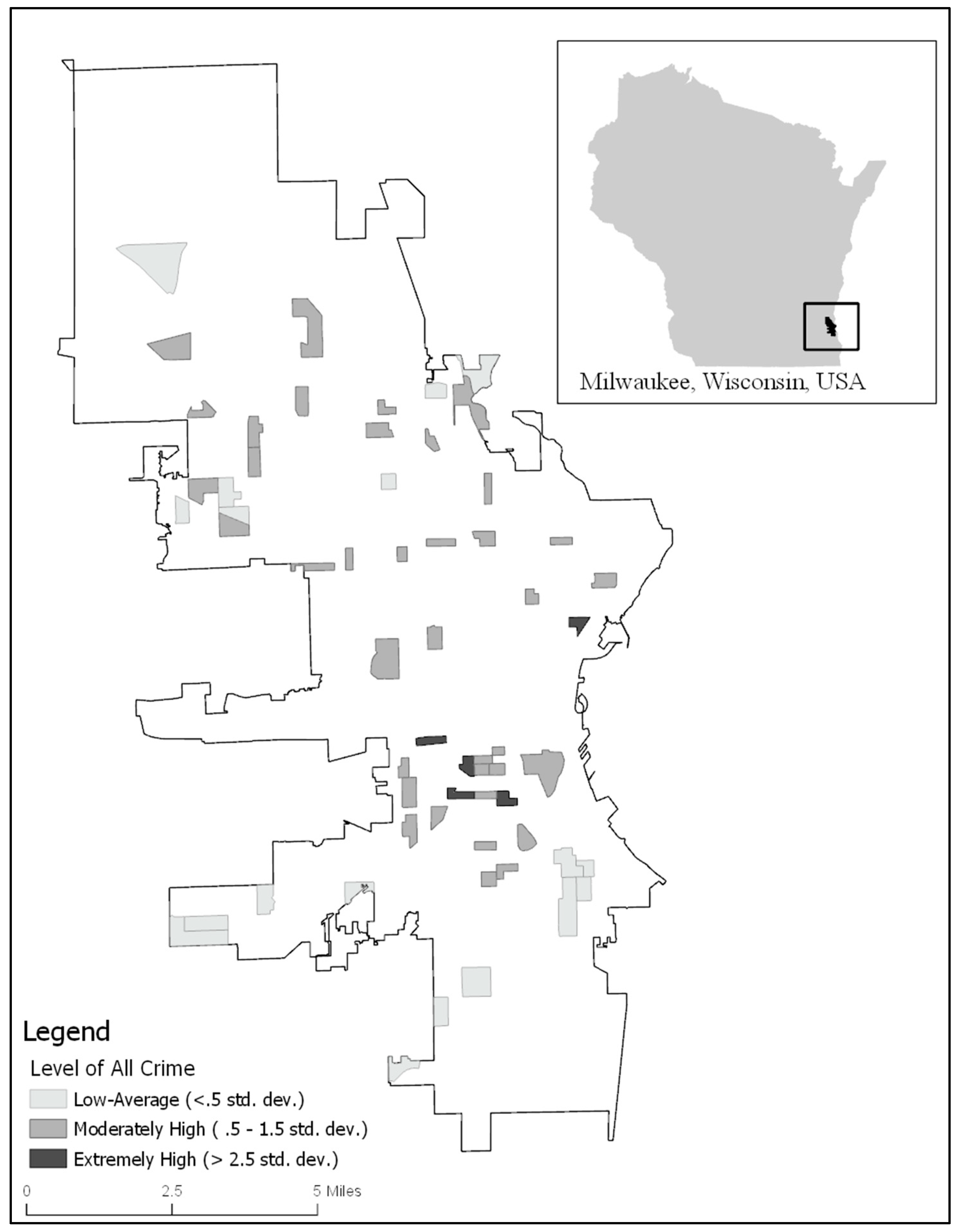
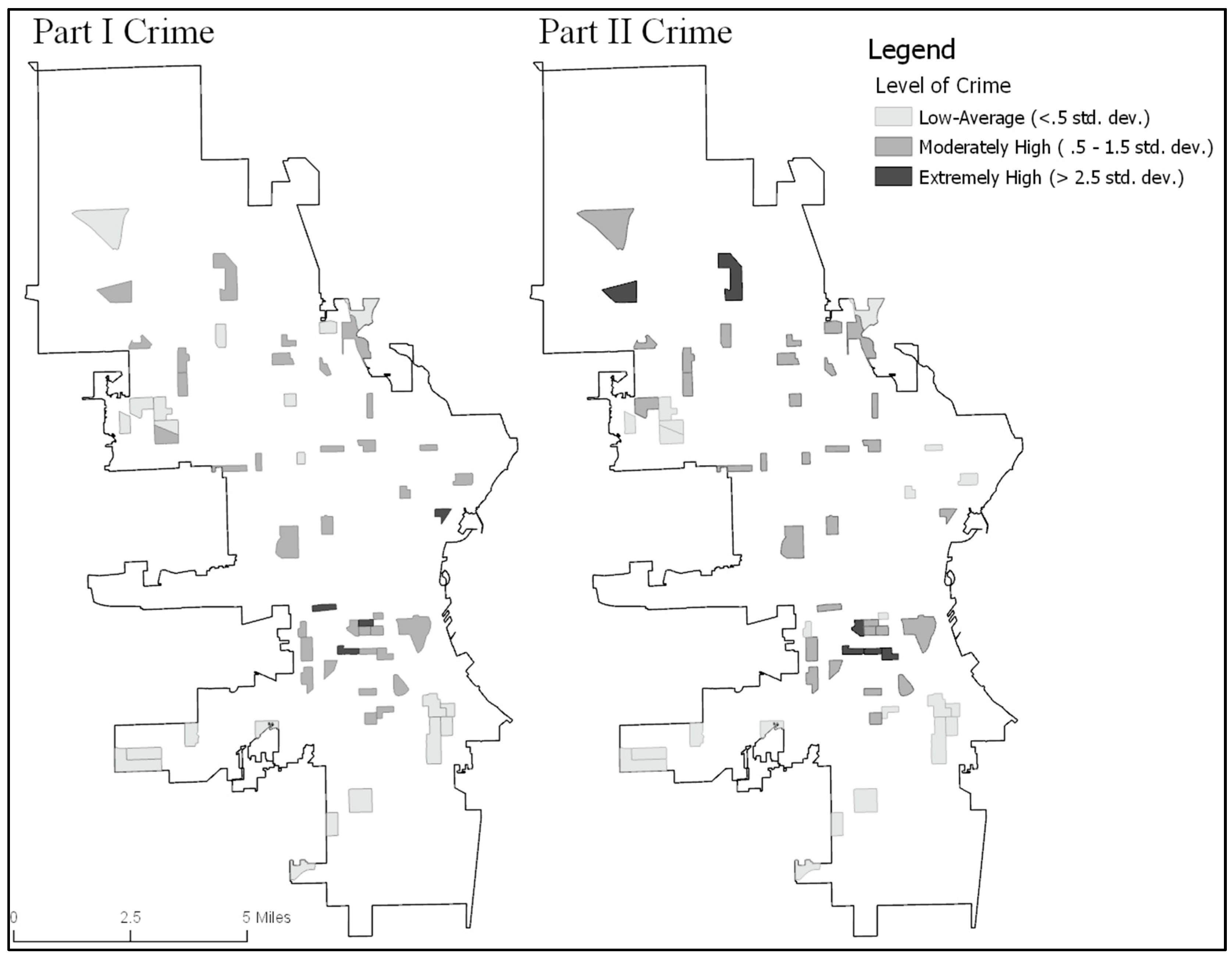
2.2. Dependent Variables

In this study, we examined the effects of neighborhood disorder on three crime outcome measures. As we are aware that residents and visitors to neighborhoods are likely move outside the bounds of the neighborhood as well as neighborhood context being likely to affect the immediate area, we created buffer zones around the perimeter of each block group. Extant findings have indicated that larger buffer areas (e.g., 1000, 1500, 3000 feet) do not produce significant differences in effects [41]. Based on this finding as well as the size of buffers used in other studies examining socio-structural effects [42,43], we created 500-foot buffer zones around the perimeter of each block group. Here, it is important to note that because buffers overlap, it is possible for one single crime to fall within more than one block group. Nonetheless, we argue that crime is likely to impact social processes in nearby block groups, and therefore, crime rates per buffered block group is the most appropriate measure.
The first dependent variable includes all offenses reported to the Wisconsin Incident Based Report (Group A Offenses) that took place within Milwaukee between 1 June and 20 September 2017 (N = 14,004) (This dataset includes the following offenses: aggravated assault, arson, burglary/breaking and entering, destruction/damage/vandalism of property, homicide, murder/non-negligent/ manslaughter, purse snatching, robbery, shoplifting, simple assault, theft from building, theft from coin-operated machines, motor vehicle theft, theft from motor vehicle, theft of motor vehicle parts/accessories, trespassing, intimidation, and all other larceny. Please note that due to the sensitivity of the offense, no sex-based offenses were included in these data.). Addresses were geocoded using a dual-ranges address locator that was built in ArcMap (version 10.3). Of these offenses, 13,616 addresses (97.2%) were matched, with 12,561 geocoded automatically (i.e., based on the address locator), and 568 hand-matched based on their addresses. The remaining 388 cases did not match due to having blank cells (i.e., missing address data). Missing/blank cells were the result of one of two reasons. First, 97 cases did not have geocodable addresses (e.g., were listed as “city at large,” or a general location). Second, due to the sensitivity of rape/sexual assault, address data on these crimes are not available (N = 291).
Next, crime point data (i.e., address matched offense data) were joined (i.e., aggregated) to the sample buffered block groups to create a count variable of the number of crimes that occurred within the sample block group. Within the sample block groups, there were 1288 crimes. Once joined to the buffered block groups; however, within buffered block groups there were 3628 crimes that fell within these areas. Here, we note that some individual offending events were counted in more than one buffered block group due to overlapping buffers.
Based on these data, we calculated the crime rate per 1000 block group residents. We refer to this measure as “All Crime” throughout. Next, offense data were disaggregated into two categories of crimes. These categories reflect the FBI’s Uniform Crime Report (UCR) division of crimes, and include Part I/Index crimes, and Part II crimes, in which Part I crimes are identified as more serious offenses. Part I crimes include four felony property crimes: burglary, larceny-theft, arson, and motor vehicle theft; and four felony violent crimes: murder, robbery, aggravated assault, and rape/sexual assault. The measure of Part I crimes used for analyses included each of the aforementioned offenses, with the exception of sex-based crimes. Part II crimes include all other crimes that are not included within the Part I crime category. Again, rates per 1000 block group residents were calculated for both Part I and Part II offenses. We refer to these measures as “Part I Crime” and “Part II Crime” throughout. (As data were collected on a sample of block groups, rather than all block groups, it was neither possible nor logical to create a spatially lagged (i.e., “rho”) variable as the nearest neighbors were often separated by several block groups.)

2.3. Independent Variables

Measures on disorder are the key independent variables of this study. The process for data collection was as follows. First, maps of all streets and parcels within the sample block groups were created. Next, between 1 June and 20 September 2017, and between the hours of 3:00 and 6:00 pm, the researchers canvased each street in each sample neighborhood to collect parcel data on 16 indices of disorder (individual items discussed below). Following the initial data collection, 10% (N = 6) of the neighborhoods were re-canvased, and disorder data were re-collected. Data from the initial collection and the re-test collection were entered into repeated measures t-Tests, which confirmed no significant difference between the initial and re-test observations (all T-values ≤ 1.581; all p-values ≥ 0.175), indicating a high likelihood of inner-rater reliability.
Although Sampson and Raudenbush’s [34] study on neighborhood disorder was used as a guide in the creation of the current study’s data collection instrument, we diverge by omitting some variables, while adding others. First, and based on the literature, we created a measure reflective of traditional measure of physical disorder (“Neighborhood Disorder”). Indices of neighborhood disorder included graffiti, piles of trash/litter, broken glass on the street/sidewalk, and abandoned cars, houses with falling/detached siding or gutters, houses with chipping/peeling paint, parcels with unkempt/overgrown lawns, houses with boarded up windows and/or doors, houses with untended fire damage, and houses with broken/missing windows (Guttman’s Lambda 6 = 0.907). Second, and also aligning with previous studies, we created a measure of “Social Disorder.” Items used to measure social disorder included people loitering, people who were intoxicated/drinking in public, people buying/selling drugs, people gambling, people engaging in a physical fight, and minors not under adult supervision (Guttman’s Lambda 6 = 0.459).
Next, and based on the more recent broken windows theory examinations discussed above, we ascertained that disorder in shared/public spaces and housing disorder may offer different signals. While any neighborhood resident can address disorder in shared spaces, only the homeowner can address incivilities that take place on their property. As such, housing disorder may be viewed as neglect by a few homeowners, whereas incivilities in shared spaces may be perceived as a function of the larger neighborhood. Based on this assumption, the neighborhood disorder measure was disaggregated to create two additional measures: “Public Space Disorder,” and “Housing Disorder.” Indices of public space disorder included graffiti, piles of trash/litter, broken glass on the street/sidewalk, and abandoned cars (Guttmann’s Lambda 6 = 0.437). Items used to measure housing disorder included houses with falling/detached siding or gutters, houses with chipping/peeling paint, parcels with unkempt/overgrown lawns, houses with boarded up windows and/or doors, houses with untended fire damage, and houses with broken/missing windows (Guttman’s Lambda 6 = 0.887) (Here, we note that Guttman’s Lambda 6 scores were low for the public space and social disorder measures. We urge future researchers to continue pursuing additional indices of disorder that may hold greater inter-scale reliability.).
Although previous studies have created dichotomous variables based on whether or not the above measures of disorder were present or absent, we ascertain that the frequency of disorder may have a greater impact on perceptions of the neighborhood. That is, a neighborhood with one house with chipping paint may be viewed as a localized “eyesore” or as an isolated event, whereas a neighborhood with several houses with chipping paint may permeate the perception of a decaying neighborhood. For this reason, the number of each disorder indicator per block group were summed, resulting in four indexes of disorder reflecting the prevalence of each type of disorder occurring within a given neighborhood.
In addition to disorder measures, we controlled for several neighborhood structural characteristics that we believe will affect crime rates. Consistent with the social disorganization literature, data on five population-based demographic measures were obtained from the 2016 American Communities Survey. These variables included the percent of residents who were unemployed, the percent of residents without a high school diploma/GED, the percent of female-headed households with minor children, the percent of households receiving SNAP (Supplemental Nutrition Assistance Program) or food stamps, and the percent of households with annual earnings that fell below the poverty line. Each of the five variables were entered into a principle component factor analysis with a varimax rotation. All variables were loaded onto one discrete factor, which had an Eigenvalue of 3.344, and all factor loadings exceeded 0.660. Consistent with the literature, we identified this factor to be a summary measure of the level of neighborhood “Disadvantage.”
As renters may be less invested in their neighborhoods, we included a measure of the percent of dwellings that are renter occupied (“Renters”). Additionally, evictions may lead to a sudden disturbance in the social and compositional climate of a neighborhood. For this reason, we included a measure of the number of evictions that took place within the 2016 calendar year within each block group (“Evictions”). Next, we included a measure of “Population Density.” The average block group was approximately 318,000 square meters (this equates to 0.123 square miles). To reflect the average area, we created a density measure based on the number of residents per 300,000 square meters. Finally, because Milwaukee is identified as one of the most racially/ethnically segregated cities in the United States [38,39], we created a measure reflecting the level of racial heterogeneity. This index is equal to 1 − ∑pi2, where pi is the proportion of each racial category within the population [44,45,46]. This index accounts for the proportion of a given racial group within the population, but also the number of racial groups within the population. This index ranges from 0 to 1, where 1 represents complete heterogeneity.

2.4. Analysis Plan

Analyses for the current study were conducted in Stata (version 14). First, univariate analysis was conducted. Next, we examined variance of inflation (VIF) scores to test for multicollinearity among variables. Across models, all VIF scores were less than 5, suggesting that multicollinearity was unlikely [47]. Next, results from the Breusch–Pagan/Cook–Weisberg tests for heteroscedasticity were examined for each model. Across models, analysis revealed non-significant Chi-square values, indicating homogeneity of variance (i.e., noise) across independent variables. For this reason, traditional standard errors (rather than robust standard errors) were deemed to be appropriate.
Next, we examined several statistics where we identified linear regression models to be the best fitting model. Crime data are often skewed and/or over-dispersed; however, surprisingly, this was not the case for the current data. Although the normality of these data are interesting and warrant further contextual analyses, based on descriptive statistics, confidence intervals, Chi-square values, and dispersion parameter coefficients (i.e., alpha), linear regression models produced the best fit models (Stata was used to test model fit for each of the following models: Poisson, zero-inflated Poisson, negative binomial regression, and zero-inflated negative binomial regression. Model fit statistics revealed that each of these models poorly fit the data, resulting in the use of linear regression modeling.). Therefore, three series of linear regression models were built to examine the relationship between all independent variables on each dependent variable.
First, we tested the effects of each type of disorder on each outcome variable. Second, we tested the full disorder model by including all measures of disorder. Here, one model tested the effects of traditional disorder measures (i.e., neighborhood disorder and social disorder) on each crime measure, and one model included the disaggregated measures (i.e., public space disorder, housing disorder) and social disorder on each crime measure. Third, we tested whether or not the effect of disorder on Part I crime rates is mediated by Part II crime rates.

3. Results

3.1. Descriptive Statistics

Descriptive statistics on all dependent and independent variables are reported in Table 1. On average, block groups had 62 crimes per 1000 residents, and this rate ranged from 3.15 to 131.28 crimes per 1000 residents across block groups (Figure 1).
When crimes rates were disaggregated into Part I and Part II offenses, the average block group had 46 Part I crimes, and nearly 16 Part II crimes per 1000 residents. Across block groups, Part I offenses ranged from approximately three to 99 offences per 1000 residents, and the rate ranged from 0 to 43 Part II offenses per 1000 residents. As expected, crime was clustered within a small number of neighborhoods. Specifically, the northern region of the city had two block groups with “extremely high” levels of Part II crimes (i.e., those block groups scoring at least 2.5 standard deviations higher than the average frequency of Part II crimes); however, extreme levels of Part I crimes were not observed within these neighborhoods (Figure 2).
Next, we turn to descriptive findings on disorder measures. On average, sample block groups had approximately 16 indices of neighborhood disorder, and ranged from 0 to 80 indicators of neighborhood disorder across block groups. When disaggregated, housing disorder was observed more frequently than public space disorder. On average, nearly 12 indicators of housing disorder were observed per neighborhood; however, the number of indices ranged from 0 to 64. The average block group had four indices of public space disorder, and these observations ranged from 0 to 16 across neighborhoods. Social disorder was the least frequent type of disorder observed, with the average block having 1.60 indicators of social disorder. Neighborhoods ranged from having no indices of social disorder to having 15 incidents of social disorder.
Different trends were identified when visually examining the spatial distribution of each disorder measure (Figure 3). For example, in the central portion of the city, there were several block groups with extremely high levels of housing disorder; however, these same block groups had low levels of public space disorder, and mixed levels of social disorder. We also observed that social disorder was peppered throughout the city, whereas housing disorder was more clustered. Furthermore, relatively few neighborhoods met the threshold to be classified as having extremely high levels of public space disorder (i.e., those scoring at least 2.5 standard deviations higher than the average frequency of physical disorder), which indicated strong clustering of physical disorder within a small number of neighborhoods.
Turning to the remaining five independent variables, on average, neighborhoods were comprised of approximately 55% of renter occupied units; however, the percentage of renter occupied unites varied greatly across block groups (s = 22.13) with a range from 2.34 to 84.79% renters. Although the average block group experienced 9.42 evictions, the number of evictions across block groups was also diverse (s = 9.09) and ranged from 0 to 42. As the disadvantage measure is a standardized factor score, this variable has a mean of 0 and a standard deviation of 1. The average block group had a population density of approximately 1341 people per 300,000 square feet, and ranged from 190.93 to 3541.44 across block groups (s = 775.91). Finally, the level of racial heterogeneity varied widely across neighborhoods, where some neighborhoods exhibited complete homogeneity (0.000), whereas others scored high levels of heterogeneity (maximum = 0.707).

3.2. Multivariate Statistics

The first set of analyses tested the effects of each disorder measure on all crime (Table 2). Across each of these models, public space disorder was the only disorder measure significantly associated with neighborhood crime rates. Interestingly, the positive association between public space disorder and crime was stronger in the full model (B = 0.312; p = 0.017), than in the model that only included the public space disorder measure (B = 0.227; p = 0.046). This, coupled with the insignificant effects of the neighborhood disorder measure, suggests that other disorder measures are suppressing the effect of public space disorder. Across models, the level of disadvantage and the percent of renter occupied housing units were positive and significant (or marginally significant) predictors of neighborhood crime rates. Finally, racial heterogeneity had a positive and marginally significant effect on each model, with the exception of the final, full model (Model 6).
Next, we turn to models examining the effects of disorder on Part I crime rates (Table 3). Within these models, and similar to the all crime models, public space disorder was the only disorder variable associated, albeit of marginal significance, with Part I crime rates. Again, the effect size and level of significance were strongest in the final, full model (Model 6). Although public space disorder was a marginally significant predictor of Part I crime rates, the coefficient size and level of significance was weaker than in the all crime model. In terms of other independent variables, the percent of renter occupied units was positively and significantly associated with Part I crime rates across each model. Similar to the all crime model, racial heterogeneity had a positive and (marginally) significant effect in all but the final, full model; however, the level of neighborhood disadvantage elicited a significant effect in only one model (Model 1).
The third set of multivariate analyses tested the associations of all exogenous variables on Part II crime rates (Table 4). These findings were more consistent with broken windows theory, in that neighborhood context had a greater effect on less serious crime. For example, while public space disorder elicited a fairly weak association with serious crime, this measure had a strong association with less serious offending/Part II crime rates (B = 0.373; p = 0.005). Additionally, the level of significance and effect size of the level of disadvantage was strongest within the Part II crime rate models. This model diverges from the previous two models, in that neither the percent of renter occupied units nor racial heterogeneity were associated with Part II crime; however, population density elicited a negative and marginally significant association across models.
The final model presented (Table 5), tested whether or not the effect of disorder on Part I crime rates is mediated by Part II crime rates. Public space disorder was the only disorder measure to show an association with Part I crime rates, and as such, we present the findings from the full model. Once Part II crime rates were entered into the model, the Analysis of Variance (ANOVA) coefficient was examined, and was found to be significant. Next, model coefficients were observed. Here, the effect of public space disorder on Part I crime rates was no longer significant (B = 0.035; p = 0.779), whereas Part II crime rates were a highly significant predictor of Part I crime rates (B = 0.599; p = 0.000). This finding suggests that the effect of public space disorder on Part I crime rates is fully mediated by Part II crime rates. Furthermore, this model had the largest r-square value across models, indicating that this model was the most capable of explaining variation in the Part I crime rates. Within this model, no other changes in levels of significance were observed.

4. Discussion

Modest support was found for broken windows theory; however, our findings indicate that traditional measures of physical disorder may not allow for the effect of disorder on crime to be fully observed. Based on analyses, public space disorder was found to predict neighborhood crime rates, whereas all other disorder measures failed to elicit significant associations. Furthermore, analyses revealed that the effect of public space disorder on Part I crime was mediated by Part II crimes.
Based on these findings, we argue that public, physical disorder may be more overt and capable of sending stronger signals of disinvestment to potential offenders. Here, we posit that disorderly physical cues offer a clear sign of neighborhood decline, whereas other neighborhood characteristics (e.g., percent renter, level of disadvantage) may operate more covertly.
Additionally, we argue that social disorder is unlikely to persist continuously, and therefore, it may be unlikely to serve as a signal to potential offenders. Harcourt [20] as well as Gau and Pratt [48] point to the importance of this, and posit that how members view signals of disorder are more important than the indices themselves. Specifically, while some behaviors may be deemed as disorderly to some individuals, these same behaviors may be viewed as normative, or non-threatening by others. Specifically, Gau and Pratt argue that signals must increase fearfulness in order for the “broken windows process” to take place. They argue that without an increase in fear, community members are no more likely to recoil or isolate themselves from the larger community [48].
Furthermore, housing disorder may be contained to an individual house, and may be viewed as a home in need of repairs, but not a function of the overall neighborhood. Whereas an individual may pick up litter or report an abandoned car within their neighborhood, a concerned resident cannot readily address problems related to the appearance of another resident’s home. As pointed out by O’Brien, Sampson, and Winship [49], housing disorder may operate differently than public disorder, as these areas are “technically private” (p. 6). For this reason, we assert that physical disorder that takes place in public and shared areas may be an important neighborhood feature to consider when attempting to combat incivilities related to less serious offending.

4.1. Policy Implications

Broken windows, or zero tolerance policing, focuses on aggressive police enforcement of misdemeanor and quality of life crimes. In a meta-analysis of 30 studies examining different forms of broken windows policing, Braga, Welsh, and Schnell [50] found that when police targeted minor crimes, a drop in more serious crime occurred. On the other end of the spectrum, zero tolerance/overtly aggressive policing is seen by some as a method of institutional or systematic racism that unfairly targets racial minorities, specifically Black and Hispanic community members [51,52]. As certain populations feel targeted, this has the ability to lead to mistrust in the police as well as an increase in complaints against law enforcement officers [20,53].
Findings from the current study suggest that minor offenses are predictive of more serious offenses; however, findings also show that public displays of physical disorder, rather than social disorder, are correlated with minor offending. Based on these findings, it is possible that addressing public physical incivilities may decrease minor offending, which in turn, may lead to decreases in serious crime. In this light, community oriented policing (COP) may be an appropriate alternative to aggressive broken windows policing techniques. Here, rather than enforcing zero tolerance policing strategies, COP argues that community partnerships are key to interrupting the process of stopping neighborhood decline.
Incorporating COP into policing practices has largely been supported by police officers and community members alike. Police officers are often receptive to COP policies, even if they believe there is still a clear need for traditional policing strategies [54]. In addition, through working with law enforcement officers, community members may develop more favorable opinions of law enforcement, which has been found to be associated with decreases in crime rates [55]. Using COP and other policing practices that bridge together police officers and community members may better allow for the identification of, and remedies for, problem areas and behaviors [53]. Beyond developing solutions, increasing relationships between police, community members, and other local organizations may result in a more holistic, and wraparound approach to addressing incivilities and low level offending. In turn, this may increase vested interest in the community, and further deplete neighborhood crime.

4.2. Limitations

As with any study, the current study is not free from limitations. First, and perhaps of greatest concern, the data used in this study were cross-sectional, which does not allow for causality to be established. Future studies should aim to test temporally lagged effects of disorder on Part II crime, and then the effects of Part II crime on later Part I offenses. Second, the crime data for this study came from the Milwaukee Police Department, and therefore, only includes crimes that were reported to or observed by police officers. Future studies may benefit from including qualitative or survey data collection methods to tap into crimes that are not reported to or observed by police officers. Third, it is possible that different types of individual crimes may be more or less sensitive to neighborhood disorder and context. This merits consideration by future tests of broken windows theory. Fourth, disorder measures were based on the researchers’ observations. It is likely that every instance of disorder was not recorded due to observation errors, outside factors (e.g., recent clean up), or not being in the “right place at the right time” to observe social disorder. Although t-Tests showed consistent data collection by observers, it is important to note this as a limitation and urge future researchers to develop additional ways of monitoring neighborhood disorder. Fifth, it is possible that other indices of social and physical disorder were not captured, and may have an effect on neighborhood crime. Future studies should continue exploring and testing contextual variables associated with offending. Sixth, fear of crime, which is the second stage in broken windows theory, was not measured. Additional research in this area should strive to incorporate this within models. Seventh, it is possible that the effects of disorder operate on microgeographic levels (e.g., blocks, street segments). As such, testing the effects of disorder on crime across varying units of analysis warrants future examination. Finally, the data for this study came from one urban city. We recognize that these findings may not be generalizable to other states, regions, or countries as well as that sociostructural and disorder effects may operate differently in non-urban areas. To increase our understanding of how these contextual effects operate across places, we call for further research on sociostructural variables, physical disorder, and social disorder in other locations.

5. Conclusions

The current study tested the effects of broken windows theory on Part I and Part II crime rates. Based on analyses, we found partial support for broken windows theory. Specifically, public space disorder was positively associated with crime rates; however, housing and social disorder failed to elicit a significant effect on crime rates. Furthermore, the effect of public space disorder was the strongest on Part II offenses, indicating that characteristics related to neighborhood decline may be more applicable to less serious offending. Moreover, the effect of public space disorder on Part I crime rates was mediated by Part II offenses.
Broken windows policing does not address many of the tenants of broken windows theory such as the presence of physical incivilities. Based on our analyses, we recommend community-law enforcement partnerships are established in areas with high levels of physical public disorder, and through partnerships with community members and organizations, work to address neighborhood incivilities. By increasing police presence and community partnerships in these areas, it may be possible to decrease public signals of disorder while increasing the residents’ investment in the community, and thereby, decreasing neighborhood crime rates.

Author Contributions

Cconceptualization, Rebecca Headley Konkel and Dominick Ratkowski; methodology, Rebecca Headley Konkel, Dominick Ratkowski, and Susannah N. Tapp; software, Rebecca Headley Konkel and Dominick Ratkowski; validation, Rebecca Headley Konkel and Dominick Ratkowski; formal analysis, Rebecca Headley Konkel and Dominick Ratkowski; investigation, Rebecca Headley Konkel and Dominick Ratkowski; resources, Rebecca Headley Konkel; data curation, Rebecca Headley Konkel and Dominick Ratkowski; writing—original draft preparation, Rebecca Headley Konkel, Dominick Ratkowski, and Susannah N. Tapp; writing—review and editing, Rebecca Headley Konkel, Dominick Ratkowski, and Susannah N. Tapp; visualization, Rebecca Headley Konkel and Dominick Ratkowski; supervision, Rebecca Headley Konkel; project administration, Rebecca Headley Konkel; funding acquisition, Rebecca Headley Konkel.

Funding

This research received no external funding.

Acknowledgments

We would like to acknowledge the reviewers for their recommendations and ideas related to this article. Their feedback allowed for a strengthened manuscript, and we thank them for this.

Conflicts of Interest

The authors declare no conflict of interest.

References

  1. Park, R.E.; Burgess, E.W.; McKenzie, R.D. The City; University of Chicago Press: Chicago, IL, USA, 2019; ISBN 0-226-63650-X. [Google Scholar]
  2. Shaw, C.R.; McKay, H.D. Juvenile Delinquency and Urban Areas; University of Chicago Press: Chicago, IL, USA, 1942. [Google Scholar]
  3. Zimbardo, P.G. The Human Choice: Individuation, Reason, and Order Versus Deindividuation, Impulse, and Chaos; University of Nebraska Press: Lincoln, NE, USA, 1969. [Google Scholar]
  4. Wilson, J.Q.; Kelling, G.L. Broken windows. Atl. Mon. 1982, 249, 29–38. [Google Scholar]
  5. Bottoms, A. Disorder, order and control signals. Br. J. Sociol. 2009, 60, 49–55. [Google Scholar] [CrossRef] [PubMed]
  6. Garofalo, J.; Laub, J. The fear of crime: Broadening our perspective. Victimology 1978, 3, 242–253. [Google Scholar]
  7. Innes, M. Signal crimes and signal disorders: Notes on deviance as communicative action 1. Br. J. Sociol. 2004, 55, 335–355. [Google Scholar] [CrossRef] [PubMed]
  8. Lewis, D.A.; Maxfield, M.G. Fear in the neighborhoods: An investigation of the impact of crime. J. Res. Crime Delinq. 1980, 17, 160–189. [Google Scholar] [CrossRef]
  9. Rohe, W.M.; Burby, R.J. Fear of crime in public housing. Environ. Behav. 1988, 20, 700–720. [Google Scholar] [CrossRef]
  10. Skogan, W.G. Disorder and Decline: Crime and the Spiral of Decay in American Neighborhoods; Univ. of California Press: Berkeley, CA, USA, 1992; ISBN 0-520-07693-1. [Google Scholar]
  11. Gates, L.B.; Rohe, W.M. Fear and reactions to crime: A revised model. Urban Aff. Q. 1987, 22, 425–453. [Google Scholar] [CrossRef]
  12. Franklin, C.A.; Franklin, T.W. Predicting fear of crime: Considering differences across gender. Fem. Criminol. 2009, 4, 83–106. [Google Scholar] [CrossRef]
  13. Innes, M. Why ‘soft’policing is hard: On the curious development of reassurance policing, how it became neighbourhood policing and what this signifies about the politics of police reform. J. Community Appl. Soc. Psychol. 2005, 15, 156–169. [Google Scholar] [CrossRef]
  14. LaGrange, R.L.; Ferraro, K.F.; Supancic, M. Perceived risk and fear of crime: Role of social and physical incivilities. J. Res. Crime Delinq. 1992, 29, 311–334. [Google Scholar] [CrossRef]
  15. Kelling, G.L.; Coles, C.M. Fixing Broken Windows: Restoring Order and Reducing Crime in Our Communities; Simon and Schuster: New York, NY, USA, 1997; ISBN 0-684-83738-2. [Google Scholar]
  16. National Research Council. Fairness and Effectiveness in Policing: The Evidence; National Academies Press: Washington, DC, USA, 2004; ISBN 0-309-28965-3. [Google Scholar]
  17. Harcourt, B.E.; Ludwig, J. Broken windows: New evidence from New York City and a five-city social experiment. U. Chi. L. Rev. 2006, 73, 271. [Google Scholar]
  18. Kelling, G.; Sousa, W. Do Police Matter? An Analysis of the Impact of New York City’s Police Reforms; Center for Civic Innovation at the Manhattan Institute: Manhattan, NY, USA, 2001. [Google Scholar]
  19. Sullivan, C.M.; O’Keeffe, Z.P. Evidence that curtailing proactive policing can reduce major crime. Nat. Hum. Behav. 2017, 1, 730. [Google Scholar] [CrossRef] [PubMed]
  20. Harcourt, B.E. Illusion of Order: The False Promise of Broken Windows Policing; Harvard University Press: Cambridge, MA, USA, 2009. [Google Scholar]
  21. Sherman, L.W. Hot spots of crime and criminal careers of places. Crime Place 1995, 4, 35–52. [Google Scholar]
  22. Weisburd, D.; Hinkle, J.C.; Braga, A.A.; Wooditch, A. Understanding the mechanisms underlying broken windows policing: The need for evaluation evidence. J. Res. Crime Delinq. 2015, 52, 589–608. [Google Scholar] [CrossRef]
  23. De Biasi, A. Transforming vacant lots: Investigating an alternative approach to reducing fear of crime. J. Environ. Psychol. 2017, 50, 125–137. [Google Scholar] [CrossRef]
  24. Garis, L.; Thomas, L.; Tyakoff, A. Distressed Properties: Pathways of Decline and the Emergence of Public Safety Risk; University of the Fraser Valley: Abootsford, BC, Canada, 2016. [Google Scholar]
  25. Gladwell, M. The Tipping Point: How Little Things Can Make a Big Difference; Little, Brown, & Company: Boston, MA, USA, 2006; ISBN 0-7595-7473-1. [Google Scholar]
  26. Perkins, D.D.; Meeks, J.W.; Taylor, R.B. The physical environment of street blocks and resident perceptions of crime and disorder: Implications for theory and measurement. J. Environ. Psychol. 1992, 12, 21–34. [Google Scholar] [CrossRef]
  27. Baumer, T.L. Research on fear of crime in the United States. Victimology 1978, 3, 254–264. [Google Scholar]
  28. Covington, J.; Taylor, R.B. Fear of crime in urban residential neighborhoods: Implications of between- and within-neighborhood sources for current models. Sociol. Q. 1991, 32, 231–249. [Google Scholar] [CrossRef]
  29. Ross, C.E.; Jang, S.J. Neighborhood disorder, fear, and mistrust: The buffering role of social ties with neighbors. Am. J. Community Psychol. 2000, 28, 401–420. [Google Scholar] [CrossRef]
  30. Taylor, R.B.; Shumaker, S.A.; Gottfredson, S.D. Neighborhood-level links between physical features and local sentiments: Deterioration, fear of crime, and confidence. J. Archit. Plan. Res. 1985, 2, 261–275. [Google Scholar]
  31. Cohen, D.A.; Inagami, S.; Finch, B. The built environment and collective efficacy. Health Place 2008, 14, 198–208. [Google Scholar] [CrossRef] [PubMed] [Green Version]
  32. Schachterle, S.E.; Bishai, D.; Shields, W.; Stepnitz, R.; Gielen, A.C. Proximity to vacant buildings is associated with increased fire risk in Baltimore, Maryland, homes. Inj. Prev. 2012, 18, 98–102. [Google Scholar] [CrossRef] [PubMed]
  33. Spelman, W. Abandoned buildings: Magnets for crime? J. Crim. Justice 1993, 21, 481–495. [Google Scholar] [CrossRef]
  34. Sampson, R.J.; Raudenbush, S.W. Systematic social observation of public spaces: A new look at disorder in urban neighborhoods. Am. J. Sociol. 1999, 105, 603–651. [Google Scholar] [CrossRef] [Green Version]
  35. United States Census Bureau American FactFinder. Available online: https://factfinder.census.gov/faces/nav/jsf/pages/index.xhtml (accessed on 18 May 2017).
  36. Bellair, P.E.; Browning, C.R. Contemporary disorganization research: An assessment and further test of the systemic model of neighborhood crime. J. Res. Crime Delinq. 2010, 47, 496–521. [Google Scholar] [CrossRef]
  37. Grannis, R. The importance of trivial streets: Residential streets and residential segregation. Am. J. Sociol. 1998, 103, 1530–1564. [Google Scholar] [CrossRef]
  38. Lee, M.R.; Ousey, G.C. Institutional access, residential segregation, and urban black homicide. Sociol. Inq. 2005, 75, 31–54. [Google Scholar] [CrossRef]
  39. Massey, D.S.; Tannen, J. A research note on trends in black hypersegregation. Demography 2015, 52, 1025–1034. [Google Scholar] [CrossRef] [Green Version]
  40. Rugh, J.S.; Massey, D.S. Segregation in post-civil rights America: Stalled integration or end of the segregated century? Bois Rev. Soc. Sci. Res. Race 2014, 11, 205–232. [Google Scholar] [CrossRef] [Green Version]
  41. Lee, H.; Vaughn, M.S.; Lim, H. The impact of neighborhood crime levels on police use of force: An examination at micro and meso levels. J. Crim. Justice 2014, 42, 491–499. [Google Scholar] [CrossRef]
  42. Warner, B.D.; Konkel, R.H. Neighborhood churches, social ties, values, and informal social control. J. Urban Affairs 2019, 41, 1183–1284. [Google Scholar] [CrossRef]
  43. Konkel, R.H. Service providers and parolees: The divergent effects of neighborhood providers on general and technical parole violation reincarceration. Corrections 2019. [Google Scholar] [CrossRef]
  44. Blau, P.M. Inequality and Heterogeneity: A Primitive Theory of Social Structure; Free Press: New York, NY, USA, 1977; Volume 7. [Google Scholar]
  45. Cahill, M.; Mulligan, G. Using geographically weighted regression to explore local crime patterns. Soc. Sci. Comput. Rev. 2007, 25, 174–193. [Google Scholar] [CrossRef]
  46. Sampson, R.J.; Groves, W.B. Community structure and crime: Testing social-disorganization theory. Am. J. Sociol. 1989, 94, 774–802. [Google Scholar] [CrossRef] [Green Version]
  47. Montgumery, D.C.; Peck, E.A. Introduction to Linear Regression Analysis, 2nd ed.; John Wiley & Sons: New York, NY, USA, 1982; ISBN 978-0-471-53387-0. [Google Scholar]
  48. O’Brien, D.T.; Sampson, R.J.; Winship, C. Ecometrics in the age of big data: Measuring and assessing “broken windows” using large-scale administrative records. Sociol. Methodol. 2015, 45, 101–147. [Google Scholar] [CrossRef]
  49. Gau, J.M.; Pratt, J.C. Broken Windows or window dressing? Citizens’ in(ability) to tell the difference between disorder and crime. Criminol. Public Saf. 2008, 7, 163–194. [Google Scholar] [CrossRef]
  50. Braga, A.A.; Welsh, B.C.; Schnell, C. Can Policing Disorder Reduce Crime? A Systematic Review and Meta-analysis. J. Res. Crime Delinq. 2015, 52, 567–588. [Google Scholar] [CrossRef]
  51. Bornstein, A. Institutional Racism, Numbers Management, and Zero-Tolerance Policing in New York City. New Am. Dialogue 2015, 18, 51–62. [Google Scholar] [CrossRef]
  52. Fagan, J.; Davies, G. Street Stops and Broken Windows: Terry, Race and Disorder in New York City. Fordham Urban Law J. 2000, 28, 457. [Google Scholar] [CrossRef] [Green Version]
  53. Greene, J.A. Zero Tolerance: A Case Study of Police Policies and Practices in New York City. Crime Delinq. 1999, 45, 171–187. [Google Scholar] [CrossRef]
  54. Jenkins, M. Police Support for Community Problem-Solving and Broken Windows Policing. Am. J. Crim. Justice 2015, 41, 220–235. [Google Scholar] [CrossRef]
  55. Murty, K.; Roebuck, J.; Smith, J. The image of the police in black Atlanta communities. J. Police Sci. Adm. 1990, 17, 250–257. [Google Scholar]
Figure 1. Map showing the level of all Part I and Part II crimes within the sample neighborhoods (N = 60).
Ijgi 08 00583 g001
Figure 2. Maps showing the level of Part I (left) and Part II (right) crimes within the sample neighborhoods (N = 60).
Ijgi 08 00583 g002
Figure 3. Map of the level of Social (left), Public Space (center), and Housing Disorder (right), within the sample neighborhoods (N = 60).
Ijgi 08 00583 g003
Table 1. Descriptive statistics of all variables within block groups (N = 60).
MeanStd. Dev.MinimumMaximum
Dependent Variables
All Crime Rate62.4232.853.15131.28
Part 1 Crime Rate46.6223.403.1598.96
Part 2 Crime Rate15.8011.200.0043.18
Independent Variables
Neighborhood Disorder16.0516.410.0080.00
Social Disorder1.602.970.0015.00
Public Space Disorder4.204.440.0016.00
Housing Disorder11.8513.160.0064.00
Disadvantage0.001.00−1.642.06
Renter54.5922.132.3484.79
Evictions9.429.090.0042.00
Population Density1340.99775.91190.933541.44
Racial Heterogeneity0.350.180.000.707
Table 2. The effects of disorder and neighborhood context on All Crime rates per 1000 residents.
Model 1Model 2Model 3Model 4Model 5Model 6
BStd. ErrorBStd. ErrorBStd. ErrorBStd. ErrorBStd. ErrorBStd. Error
Intercept26.40115.15334.14813.38424.01112.75331.44615.50126.95215.12633.71214.879
Neighborhood Disorder0.0730.258−−−−−−−−−−−−−−−−−−0.1480.291−−−−−−
Social Disorder−−−−−−−0.0761.164−−−−−−−−−−−−−0.1321.313−0.1161.268
Public Space Disorder−−−−−−−−−−−−0.227*0.820−−−−−−−−−−−−0.312*0.940
Housing Disorder−−−−−−−−−−−−−−−−−−−0.0060.318−−−−−−−0.1110.379
Disadvantage0.385*6.1120.475**5.0360.315†5.1890.453*6.1330.367†6.1210.403*5.920
Renters0.311*0.2240.290†0.2180.300*0.2110.290†0.2270.328*0.2250.266†0.221
Evictions0.0770.4350.0920.4400.0640.4210.0780.4360.1010.4410.0800.426
Population Density−0.1020.005−0.1190.005−0.1020.005−0.1000.005−0.1380.005−0.1290.005
Racial Heterogeneity0.187†17.5160.15617.3340.172†16.3130.171†17.8850.174†17.6040.11917.519
R20.5600.5620.5900.5580.5710.609
p < 0.10;* p < 0.05; ** p < 0.01; *** p < 0.001.
Table 3. The effects of disorder and neighborhood context on Part I crime rates per 1000 residents.
Model 1Model 2Model 3Model 4Model 5Model 6
BStd. ErrorBStd. ErrorBStd. ErrorBStd. ErrorBStd. ErrorBStd. Error
Intercept13.71611.26620.14610.00914.0199.59616.44411.54814.06811.28117.79211.343
Neighborhood Disorder0.1080.192−−−−−−−−−−−−−−−−−−0.1760.217−−−−−−
Social Disorder−−−−−−−0.0520.871−−−−−−−−−−−−−0.1190.980−0.1070.966
Public Space Disorder−−−−−−−−−−−−0.208†0.617−−−−−−−−−−−−0.258†0.717
Housing Disorder−−−−−−−−−−−−−−−−−−0.044.237−−−−−−−0.0370.289
Disadvantage0.2584.5440.370*3.7660.2293.9050.3124.5690.2424.5650.2694.513
Renters0.387*0.1670.358*0.1630.366*0.1590.373*0.1690.403*0.1680.355*0.168
Evictions0.0340.3230.0460.3290.0220.3170.0360.3250.0560.3290.0400.325
Population Density−0.0510.003−0.0610.004−0.0500.003−0.0490.004−0.0830.004−0.0760.004
Racial Heterogeneity0.210*13.0230.177†12.9640.188†12.2750.200†13.3240.198†13.1290.15513.356
R20.5210.5170.5430.5160.5290.522
p < 0.10; * p < 0.05; ** p < 0.01; *** p < 0.001.
Table 4. The effects of disorder and neighborhood context on Part II crime rates per 1000 residents.
Model 1Model 2Model 3Model 4Model 5Model 6
BStd. ErrorBStd. ErrorBStd. ErrorBStd. ErrorBStd. ErrorBStd. Error
Intercept12.6855.41614.0014.7459.9924.55614.0014.74512.8845.40515.9205.163
Neighborhood Disorder−0.0120.092−−−−−−−−−−−−−−−−−−0.0670.104−−−−−−
Social Disorder−−−−−−−0.1130.413−−−−−−−−−−−−−0.1390.469−0.1180.440
Public Space Disorder−−−−−−−−−−−−0.227†0.293−−−−−−−−−−−−0.373**0.326
Housing Disorder−−−−−−−−−−−−−−−−−−−0.1130.413−−−−−−−0.2460.132
Disadvantage0.585**2.1850.614***6.9440.441**1.8540.614***1.7850.566**2.1870.612***2.054
Renters0.1020.0800.1030.0530.1130.0750.1030.0770.1200.0800.0390.077
Evictions0.1520.1550.1740.2170.1380.1500.1740.1560.1780.1580.1510.148
Population Density−0.1920.002−0.220†−0.003−0.194†0.002−0.220†0.002−0.229†0.002−0.217†0.002
Racial Heterogeneity0.1106.2610.0885.3610.1115.8280.0886.1450.0966.2910.0236.079
R20.5260.5350.5580.5350.5370.603
p < 0.10; * p < 0.05; ** p < 0.01; *** p < 0.001.
Table 5. Test of mediation of disorder and neighborhood context on Part I crime rates.
Part I Crime Rates
BStd. Error
Intercept−1.93910.304
Social Disorder−0.0360.814
Public Space Disorder0.0350.645
Housing Disorder0.1110.247
Disadvantage−0.0974.161
Renters0.331*0.140
Evictions−0.0510.275
Population Density0.0540.003
Racial Heterogeneity0.14111.144
Part II Crime Rate0.599***0.257
R20.695
* p < 0.05; ** p < 0.01; *** p < 0.001.

