Spatiotemporal Distribution of Nonseismic Landslides during the Last 22 Years in Shaanxi Province, China

 ,
, 
Abstract
1. Introduction
2. Materials and Methodology
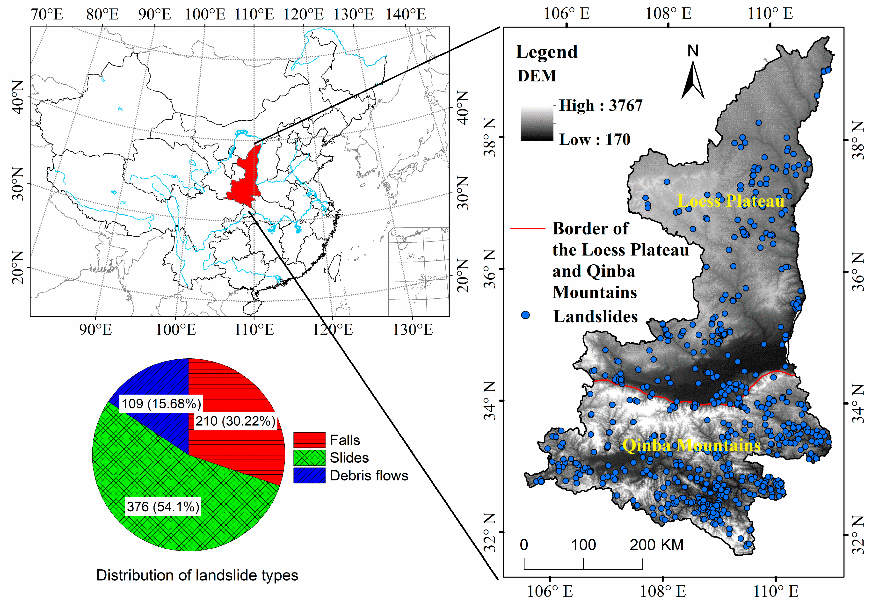
2.1. Study Area
2.2. Data Collection
2.3. Methods
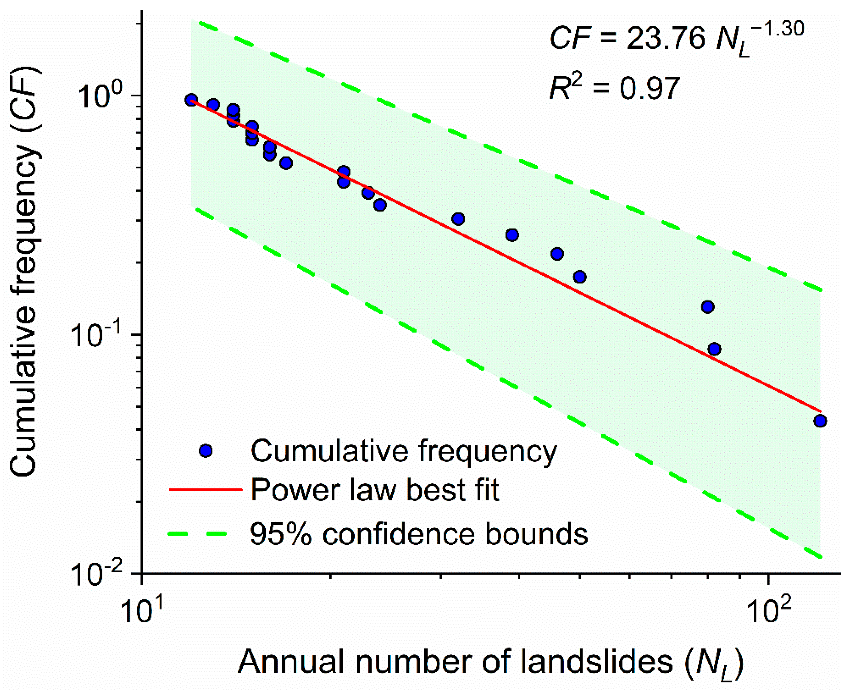
2.3.1. Power-Law Relationship
2.3.2. Exponential Relationship
2.3.3. Spatial Analysis of Landslides
3. Results and Interpretation
3.1. The Temporal Distribution of Landslides
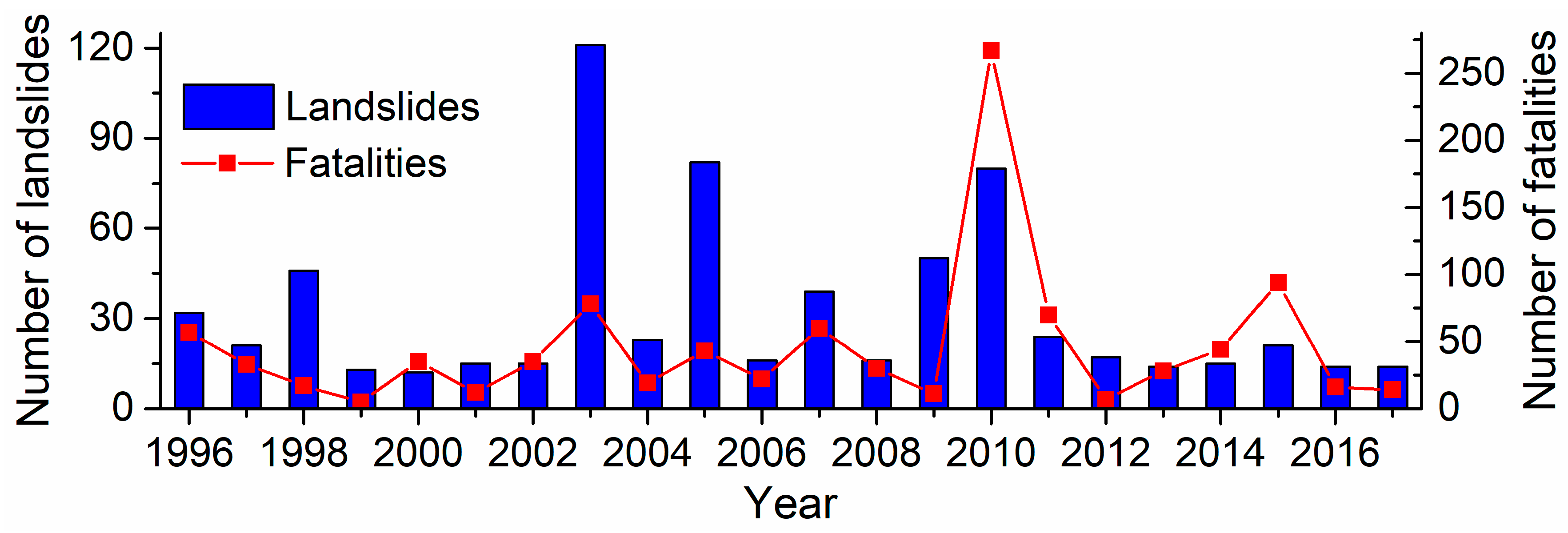
3.1.1. Annual Distribution of Landslides
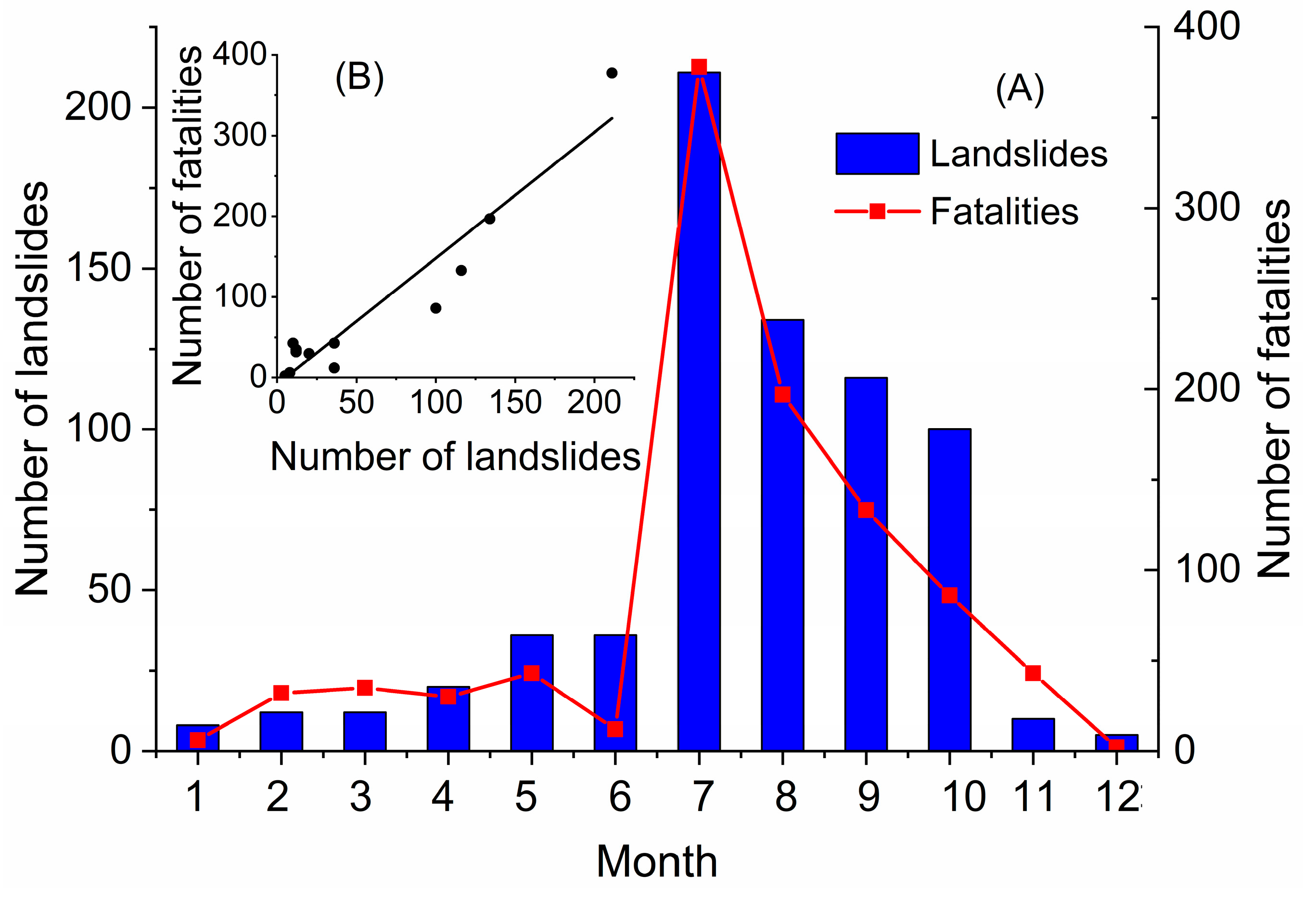
3.1.2. Monthly and Seasonal Distribution of Landslides
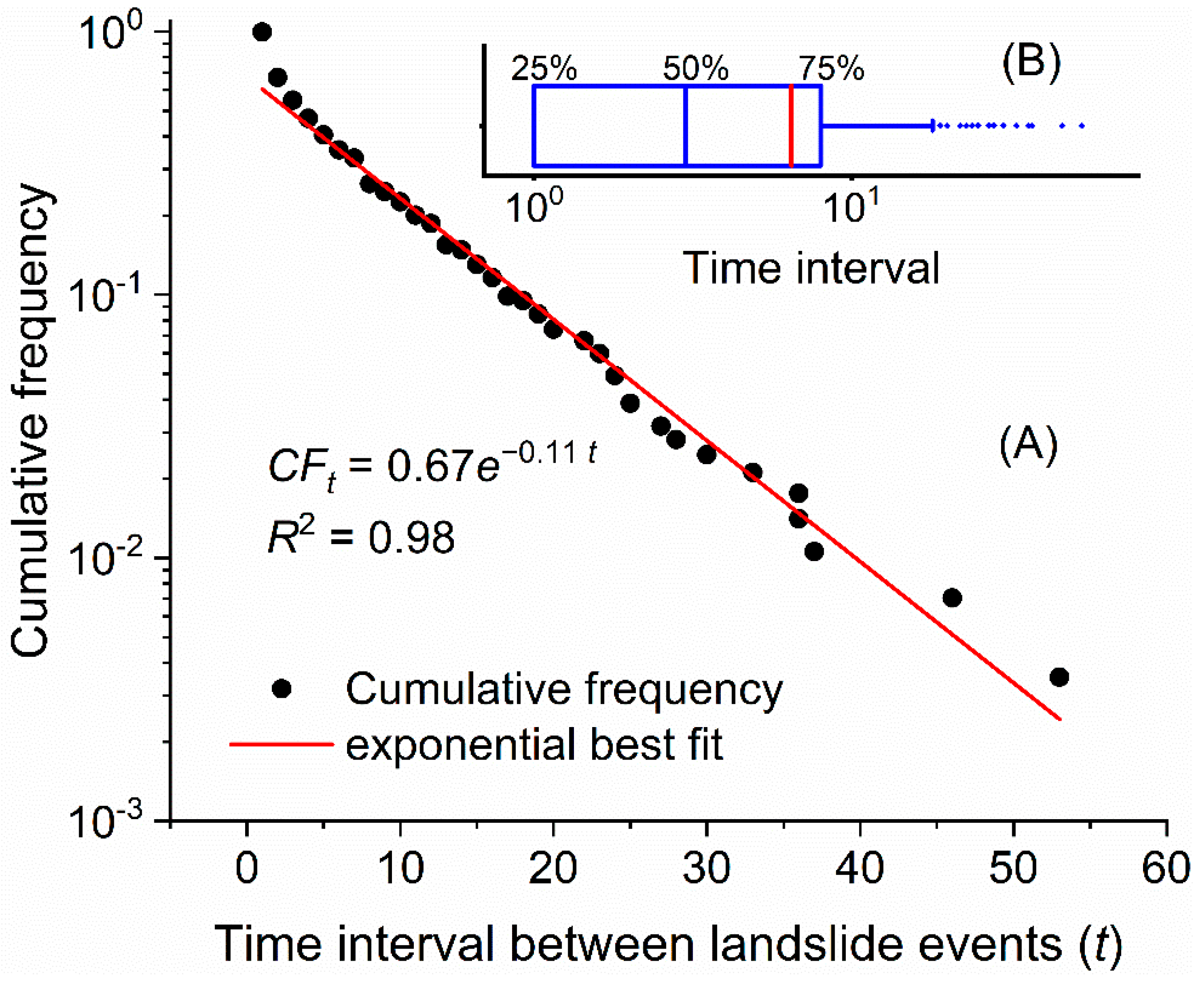
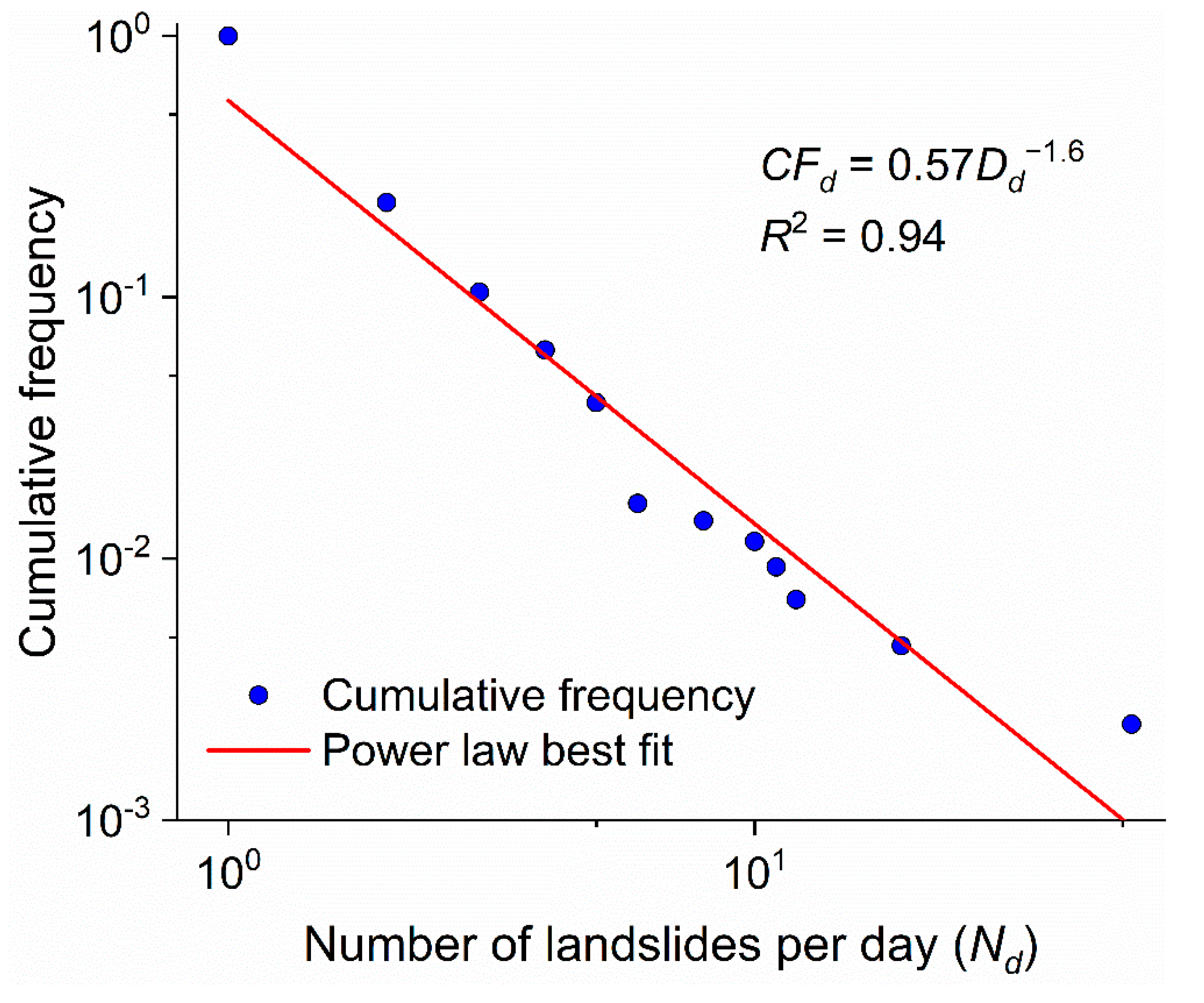
3.1.3. Daily Landslide Number and Time Intervals between Landslide Occurences
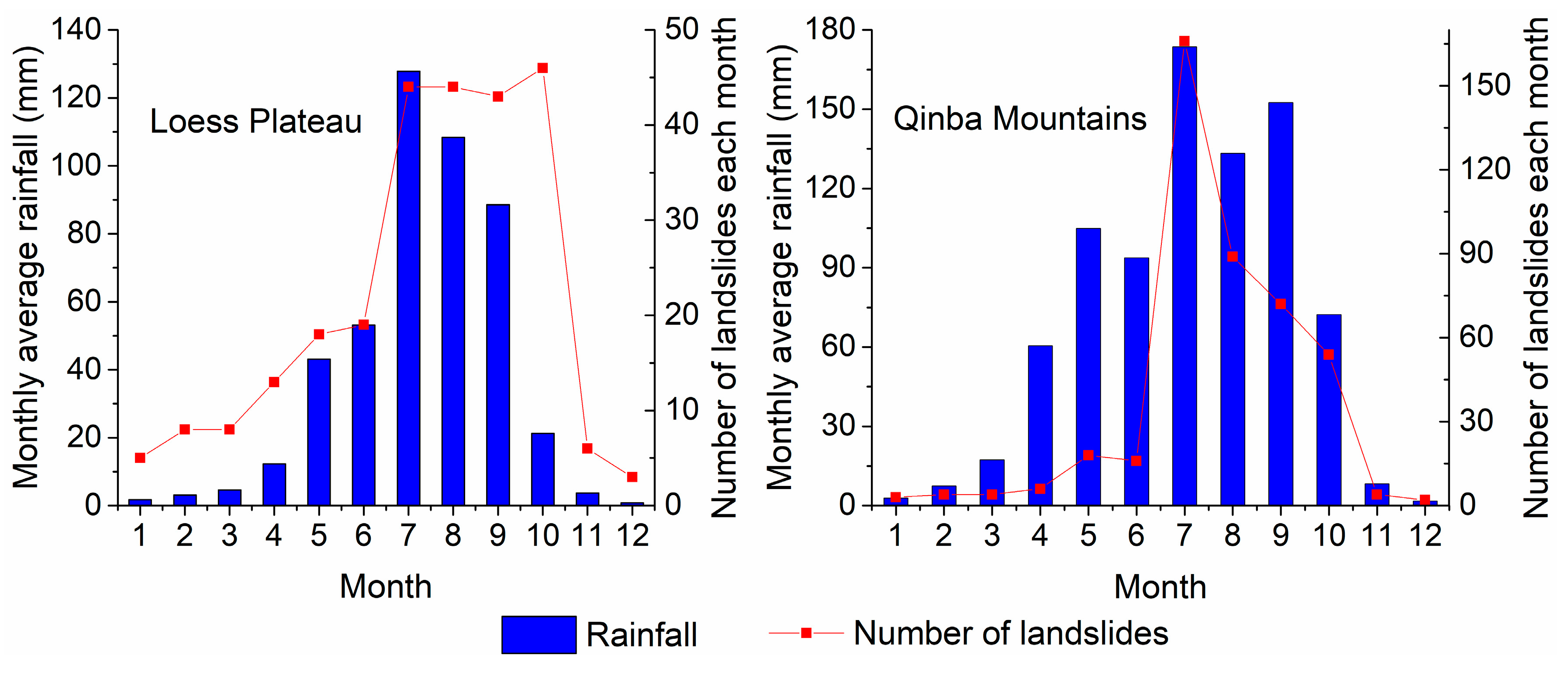
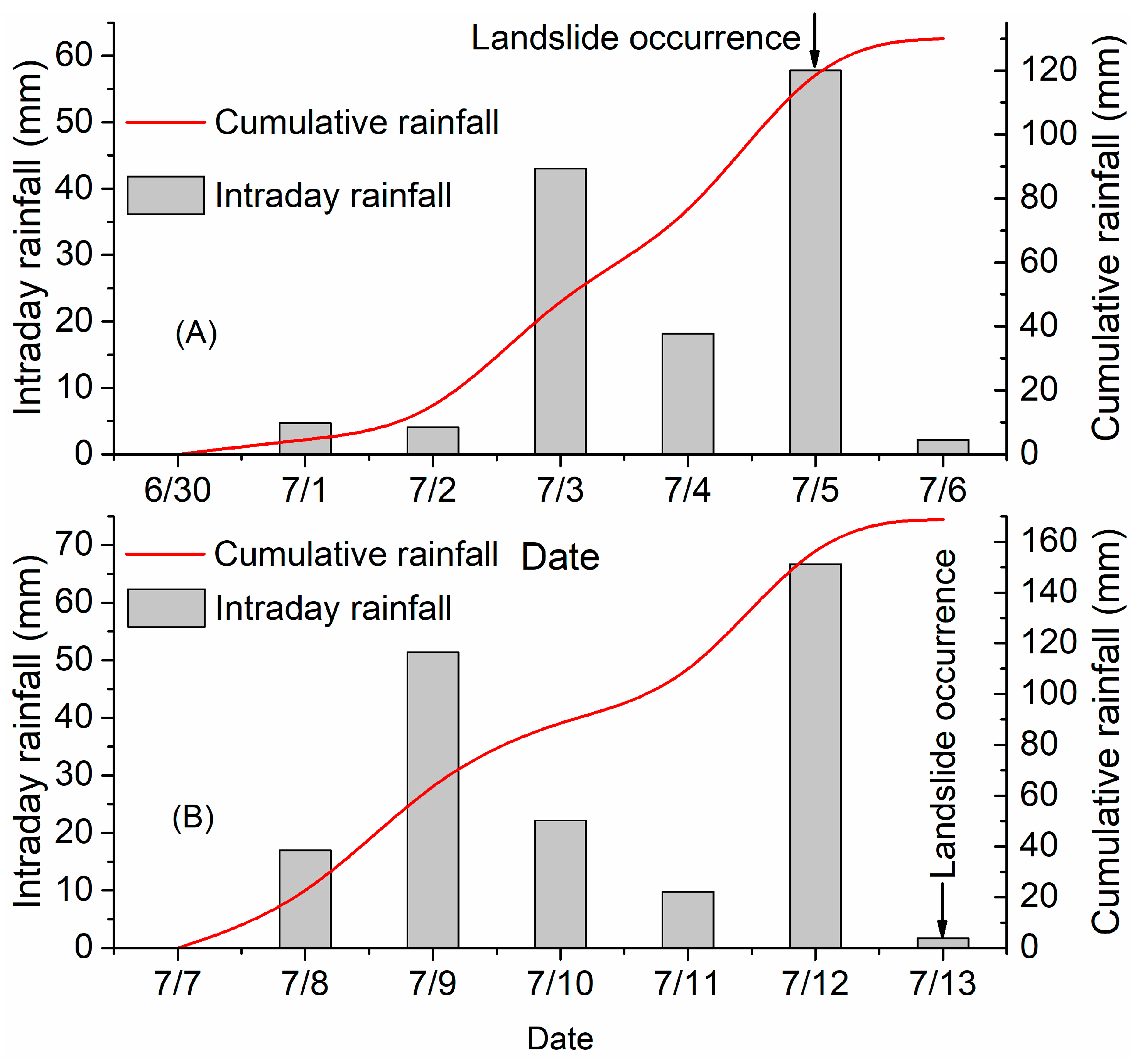
3.1.4. Landslide Distribution Associated with Rainfall
3.2. The Spatial Distribution of Landslides
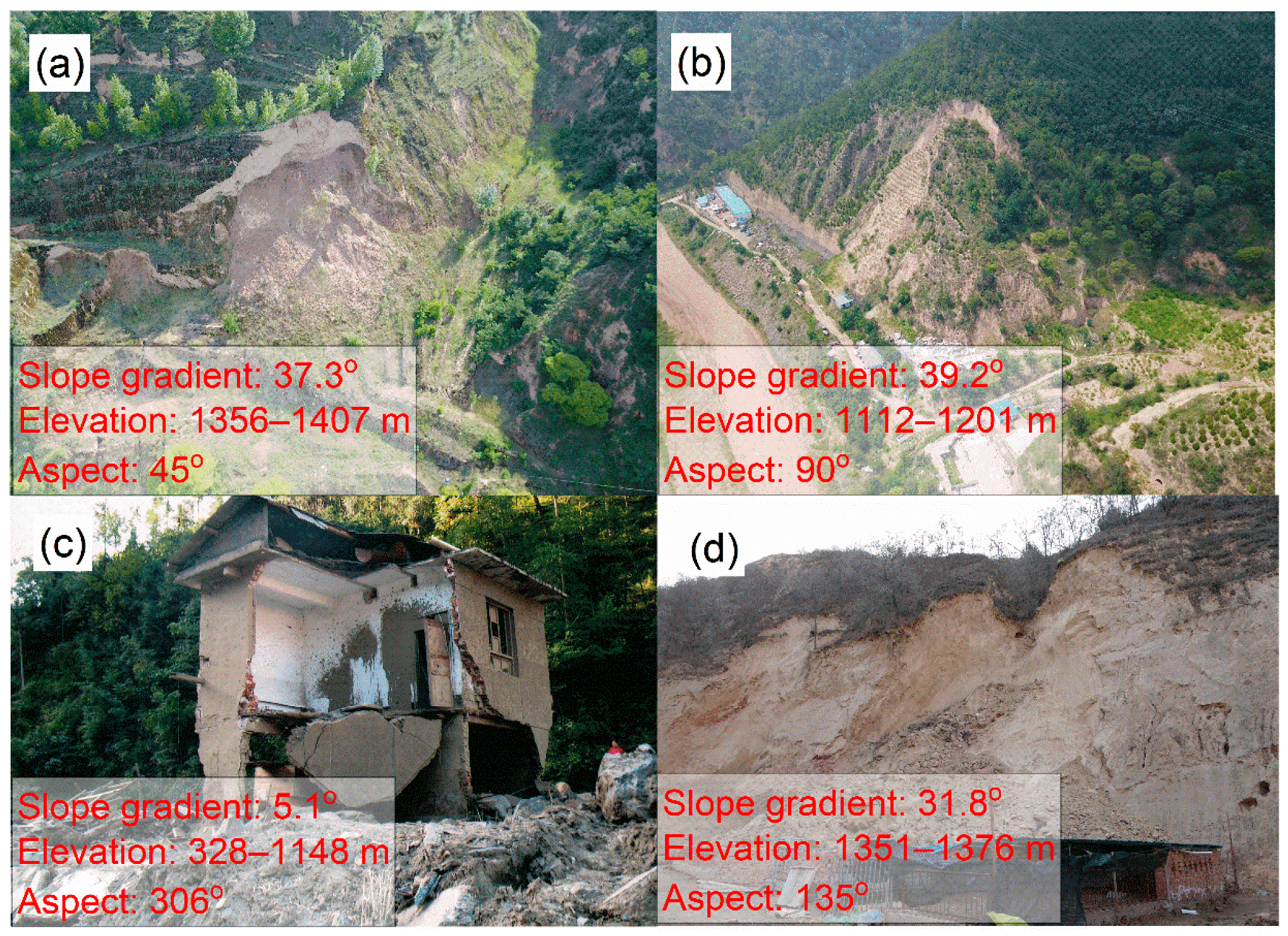
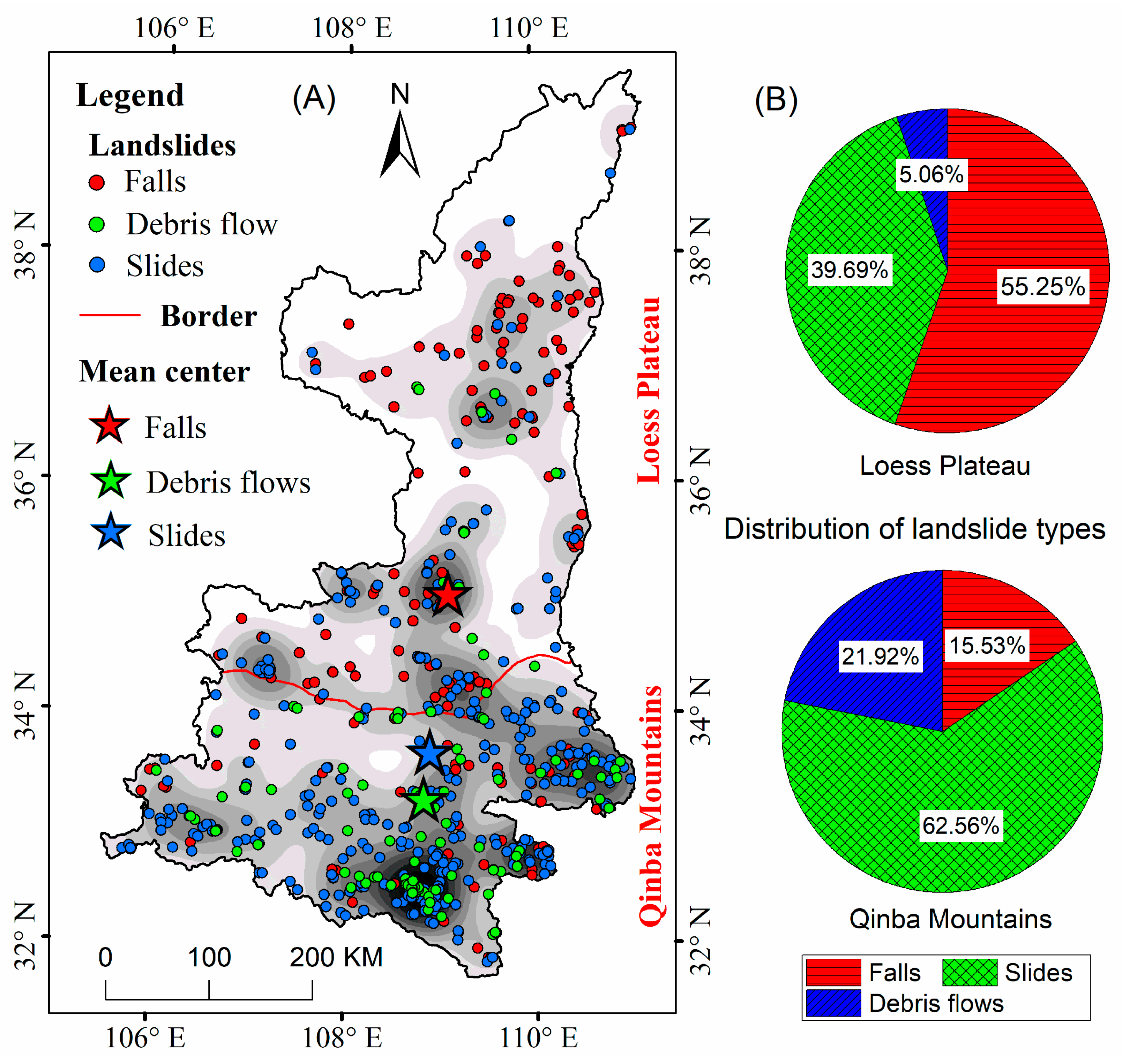
3.2.1. Geographical Distribution of Landslide Types and Densities among Different Geomorphologic Types
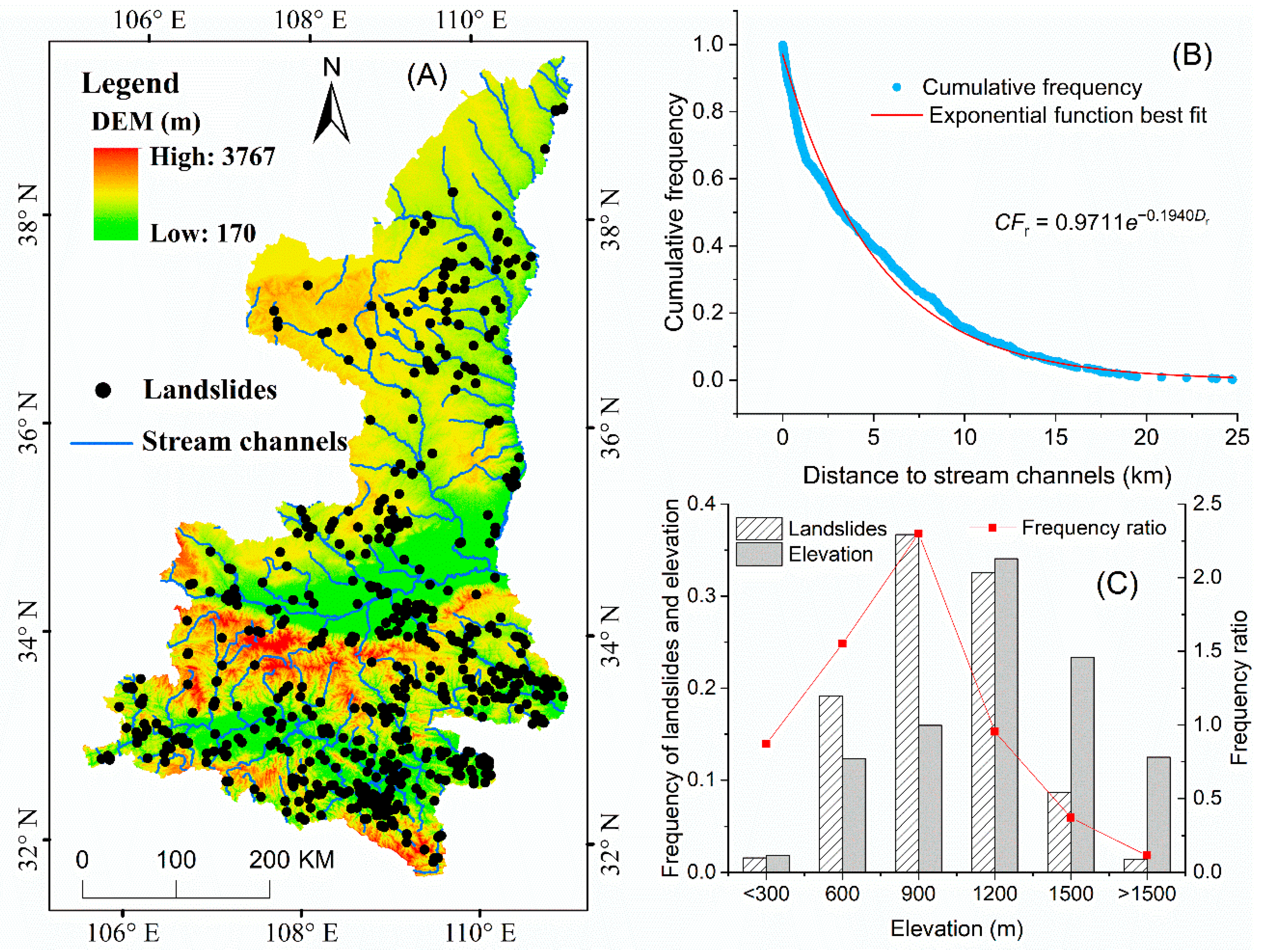
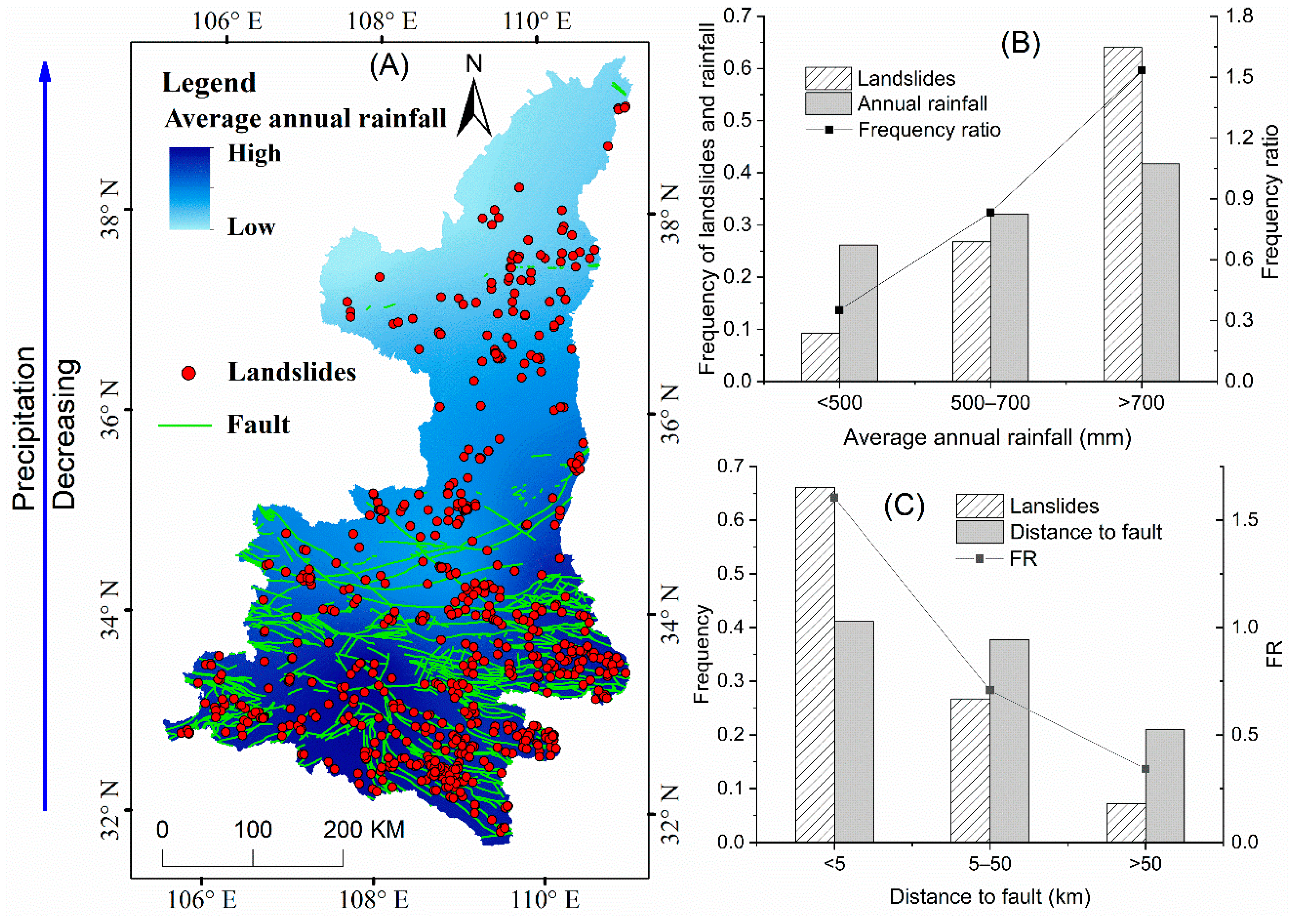
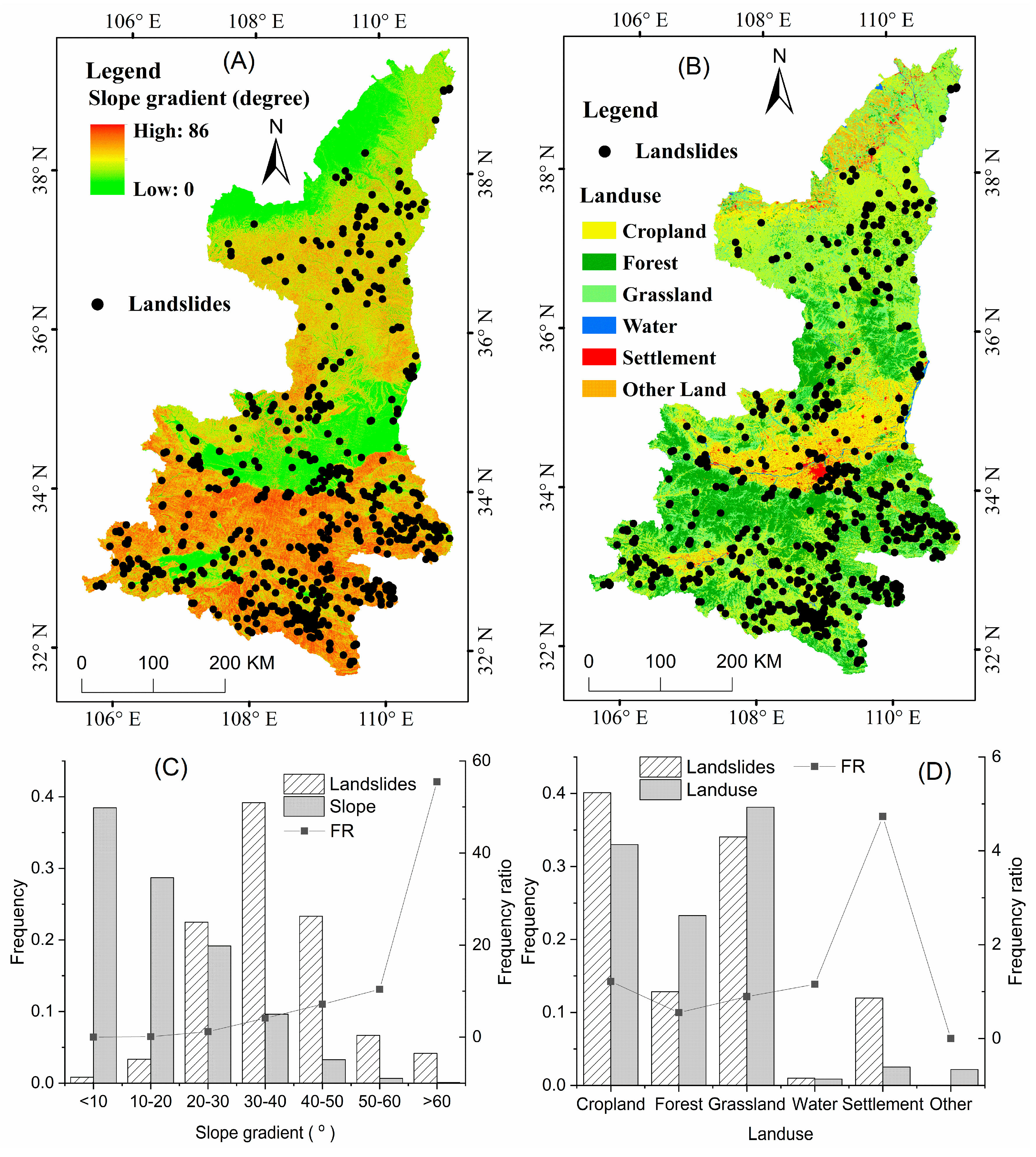
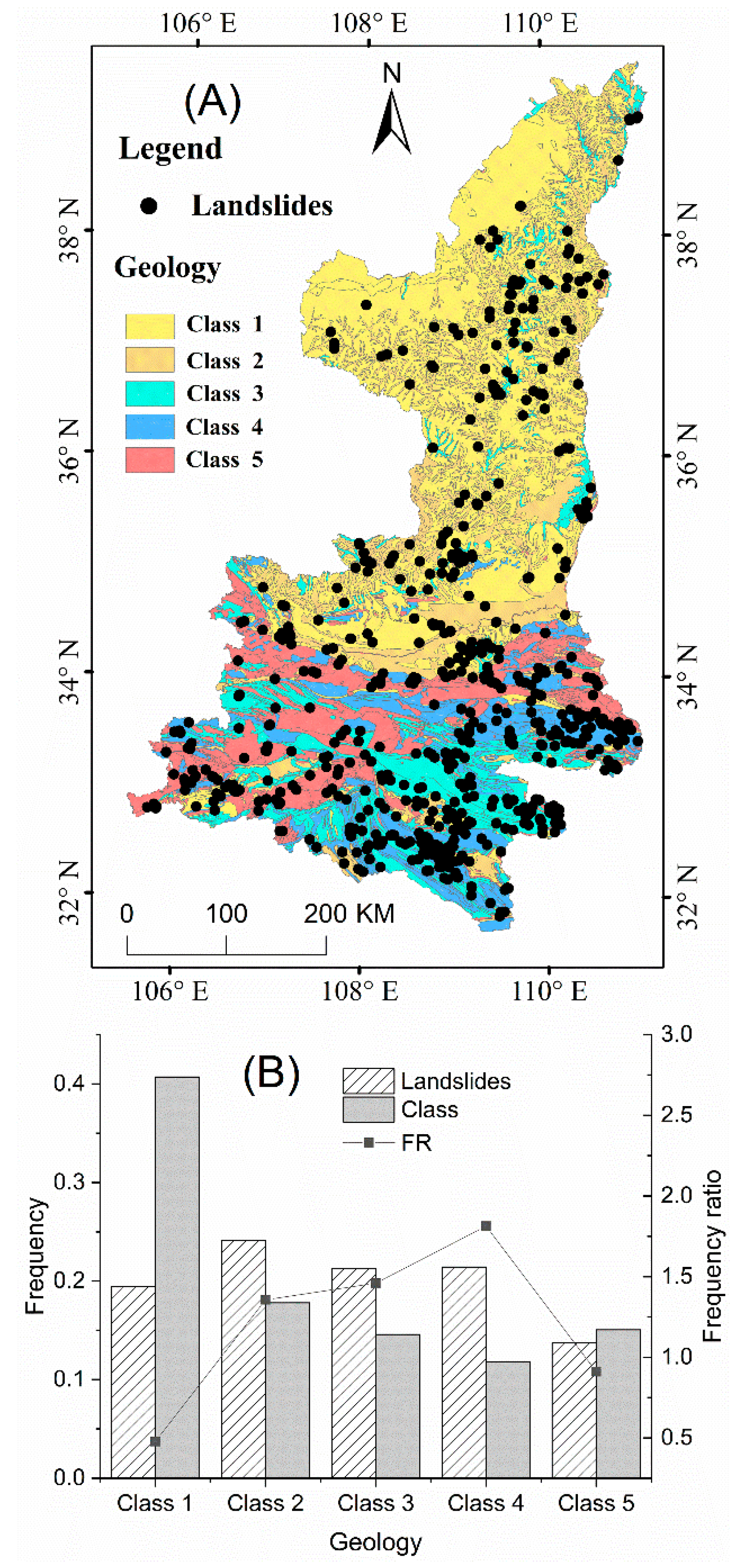
3.2.2. Relationships between Landslides and Influencing Factors
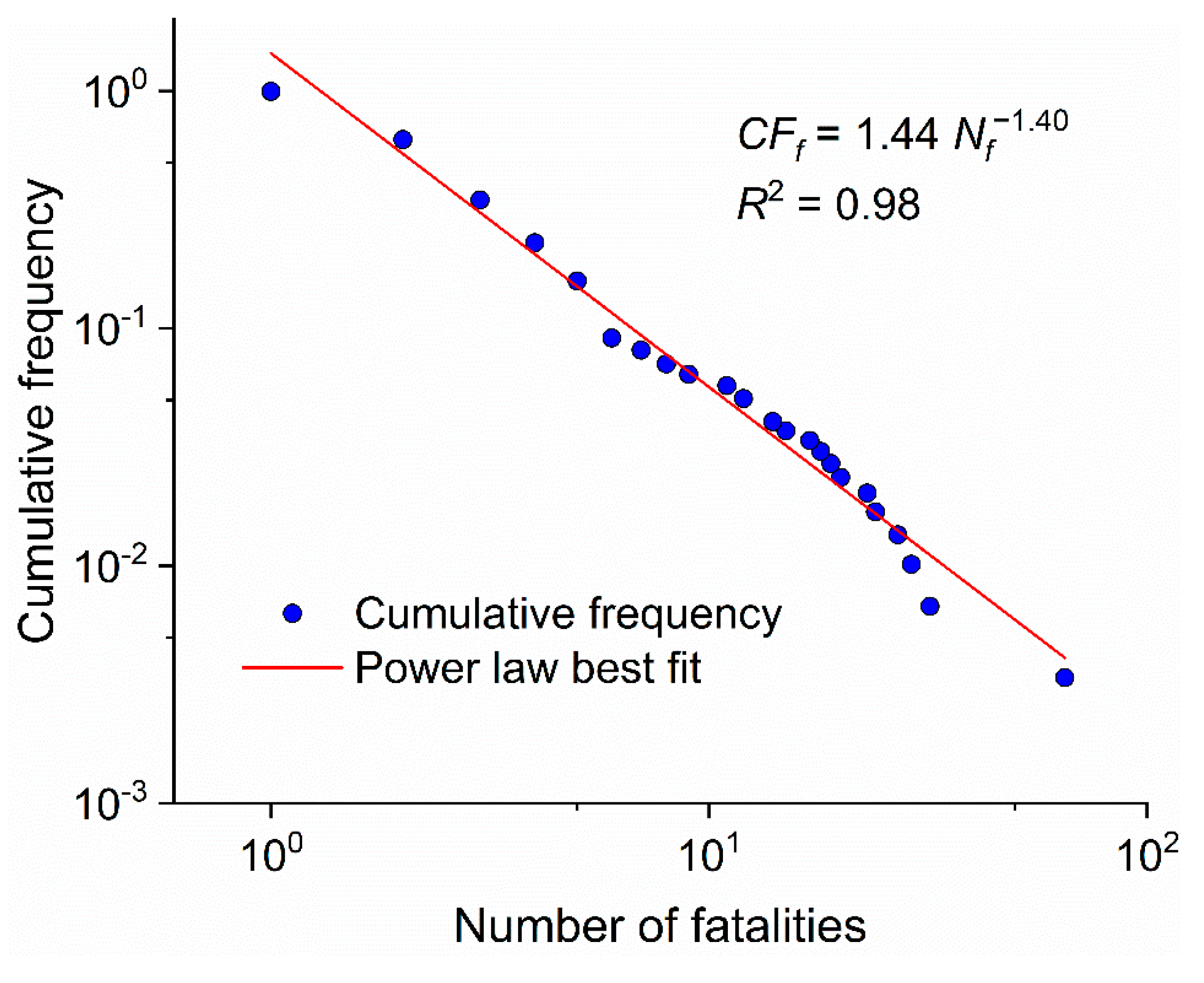
3.3. Distribution of Fatality Numbers
4. Discussion
4.1. Completeness of Landslide Catalogs
4.2. Temporal Distribution of Landslides
4.2.1. Frequency Distribution of the Time Intervals between Landslide Events
4.2.2. Frequency Distribution of Daily Landslide Numbers
4.2.3. The Relation between Landslide Events and Rainfall
4.3. Spatial Distribution of Landslides
4.4. Distribution of the Fatality Numbers
5. Conclusions
Author Contributions
Funding
Acknowledgments
Conflicts of Interest
References
- Brabb, E.E. The World Landslide Problem. Episodes 1991, 14, 52–61. [Google Scholar] [CrossRef]
- Fell, R. Landslide risk assessment and acceptable risk. Can. Geotech. J. 1994, 31, 261–272. [Google Scholar] [CrossRef]
- Qiu, H.; Cui, P.; Hu, S.; Regmi, A.D.; Wang, X.; Yang, D. Developing empirical relationships to predict loess slide travel distances: A case study on the Loess Plateau in China. Bull. Eng. Geol. Environ. 2018, 77, 1299–1309. [Google Scholar] [CrossRef]
- Salvati, P.; Bianchi, C.; Rossi, M.; Guzzetti, F. Societal landslide and flood risk in Italy. Nat. Hazards Earth Syst. Sci. 2010, 10, 465–483. [Google Scholar] [CrossRef]
- Petley, D. Global patterns of loss of life from landslides. Geology 2012, 40, 927–930. [Google Scholar] [CrossRef]
- Trigila, A.; Iadanza, C.; Esposito, C.; Scarascia-Mugnozza, G. Comparison of Logistic Regression and Random Forests techniques for shallow landslide susceptibility assessment in Giampilieri (NE Sicily, Italy). Geomorphology 2015, 249, 119–136. [Google Scholar] [CrossRef]
- Cui, Y.; Zhou, X.J.; Guo, C.X. Experimental study on the moving characteristics of fine grains in wide grading unconsolidated soil under heavy rainfall. J. Mt. Sci. 2017, 14, 417–431. [Google Scholar] [CrossRef]
- Cui, Y.; Cheng, D.; Choi, C.E.; Jin, W.; Lei, Y.; Kargel, J.S. The cost of rapid and haphazard urbanization: Lessons learned from the Freetown landslide disaster. Landslides 2019, 16, 1167–1176. [Google Scholar] [CrossRef]
- Derbyshire, E.; Van Asch, T.; Billard, A.; Meng, X. Modelling the erosional susceptibility of landslide catchments in thick loess: Chinese variations on a theme by Jan de Ploey. Catena 1995, 25, 315–331. [Google Scholar] [CrossRef]
- Zhuang, J.; Peng, J.; Wang, G.; Javed, I.; Wang, Y.; Li, W. Distribution and characteristics of landslide in Loess Plateau: A case study in Shaanxi province. Eng. Geol. 2018, 236, 89–96. [Google Scholar] [CrossRef]
- Qiu, H.; Cui, P.; Regmi, A.D.; Hu, S.; Zhang, Y.; He, Y. Landslide distribution and size versus relative relief (Shaanxi Province, China). Bull. Eng. Geol. Environ. 2018, 77, 1331–1342. [Google Scholar] [CrossRef]
- Zhang, F.; Huang, X. Trend and spatiotemporal distribution of fatal landslides triggered by non-seismic effects in China. Landslides 2018, 15, 1663–1674. [Google Scholar] [CrossRef]
- Keefer, D.K.; Larsen, M.C. Assessing landslide hazards. Science 2007, 316, 1136–1138. [Google Scholar] [CrossRef] [PubMed]
- Corominas, J.; Moya, J. A review of assessing landslide frequency for hazard zoning purposes. Eng. Geol. 2008, 102, 193–213. [Google Scholar] [CrossRef]
- Fell, R.; Corominas, J.; Bonnard, C.; Cascini, L.; Leroi, E.; Savage, W.Z.; on behalf of the JTC-1 Joint Technical Committee on Landslides and Engineered Slopes (2008). Guidelines for landslide susceptibility, hazard and risk zoning for land use planning. Eng. Geol. 2008, 102, 85–98. [Google Scholar] [CrossRef]
- Witt, A.; Malamud, B.D.; Rossi, M.; Guzzetti, F.; Peruccacci, S. Temporal correlations and clustering of landslides. Earth Surf. Process. Landf. 2010, 35, 1138–1156. [Google Scholar] [CrossRef]
- Korup, O. Geomorphic imprint of landslides on alpine river systems, southwest New Zealand. Earth Surf. Process. Landf. 2005, 30, 783–800. [Google Scholar] [CrossRef]
- Rossi, M.; Witt, A.; Guzzetti, F.; Malamud, B.D.; Peruccacci, S. Analysis of historical landslide time series in the Emilia-Romagna region, northern Italy. Earth Surf. Process. Landf. 2010, 35, 1123–1137. [Google Scholar] [CrossRef]
- Paudel, P.P.; Omura, H.; Kubota, T.; Inoue, T. Spatio-temporal patterns of historical shallow landslides in a volcanic area, Mt. Aso, Japan. Geomorphology 2017, 88, 21–33. [Google Scholar] [CrossRef]
- Baum, R.L.; Godt, J.W. Early warning of rainfall-induced shallow landslides and debris flows in the USA. Landslides 2010, 7, 259–272. [Google Scholar] [CrossRef]
- Guzzetti, F.; Reichenbach, P.; Cardinali, M.; Galli, M.; Ardizzone, F. Probabilistic landslide hazard assessment at the basin scale. Geomorphology 2005, 72, 272–299. [Google Scholar] [CrossRef]
- Qiu, H.; Cui, Y.; Hu, S.; Yang, D.; Pei, Y.; Yang, W. Temporal and spatial distributions of landslides in the Qinba Mountains, Shaanxi Province, China. Geomat. Nat. Hazards Risk. 2019, 10, 599–621. [Google Scholar] [CrossRef]
- Varnes, D.J. Landslide Hazard Zonation: A Review of Principles and Practice; Natural Hazards Series 3; Commission on Landslides of the IAEG; UNESCO: Paris, France, 1984; p. 63. [Google Scholar]
- Yin, J.; Chen, J.; Xu, X.; Wang, X.; Zheng, Y. The characteristics of the landslides triggered by the Wenchuan Ms 8.0 earthquake from Anxian to Beichuan. J. Asian Earth Sci. 2010, 37, 452–459. [Google Scholar] [CrossRef]
- Van Asch, T.W.; Van Steijn, H. Temporal patterns of mass movements in the French Alps. Catena 1991, 18, 515–527. [Google Scholar] [CrossRef]
- Dikau, R.; Schrott, L. The temporal stability and activity of landslides in Europe with respect to climatic change (TESLEC): Main objectives and results. Geomorphology 1999, 30, 1–12. [Google Scholar] [CrossRef]
- Piacentini, D.; Troiani, F.; Daniele, G.; Pizziolo, M. Historical geospatial database for landslide analysis: The Catalogue of Landslide OCcurrences in the Emilia-Romagna Region (CLOCkER). Landslides 2018, 15, 811–822. [Google Scholar] [CrossRef]
- Guzzetti, F.; Mondini, A.C.; Cardinali, M.; Fiorucci, F.; Santangelo, M.; Chang, K.T. Landslide inventory maps: New tools for an old problem. Earth-Sci. Rev. 2012, 112, 42–66. [Google Scholar] [CrossRef]
- Kirschbaum, D.; Stanley, T.; Zhou, Y. Spatial and temporal analysis of a global landslide catalog. Geomorphology 2015, 249, 4–15. [Google Scholar] [CrossRef]
- Pennington, C.; Freeborough, K.; Dashwood, C.; Dijkstra, T.; Lawrie, K. The National Landslide Database of Great Britain: Acquisition, communication and the role of social media. Geomorphology 2015, 249, 44–51. [Google Scholar] [CrossRef]
- Lin, Q.; Wang, Y. Spatial and temporal analysis of a fatal landslide inventory in China from 1950 to 2016. Landslides 2018, 15, 2357–2372. [Google Scholar] [CrossRef]
- Qiu, H.; Cui, P.; Regmi, A.D.; Hu, S.; Wang, X.; Zhang, Y. The effects of slope length and slope gradient on the size distributions of loess slides: Field observations and simulations. Geomorphology 2018, 300, 69–76. [Google Scholar] [CrossRef]
- Liu, T.S. Loess and Environment; China Ocean Press: Beijing, China, 1985. [Google Scholar]
- Shao, S. Qinling Orogenic Belt: Its Palaeozoic-Mesozoic Evolution and Metallogenesis. Acta Geol. Sin.-Engl. Ed. 2000, 74, 452–457. [Google Scholar] [CrossRef]
- Qiu, H.; Cui, P.; Regmi, A.D.; Hu, S.; Wang, X.; Zhang, Y.; He, Y. Influence of topography and volume on mobility of loess slides within different slip surfaces. Catena 2017, 157, 180–188. [Google Scholar] [CrossRef]
- Chen, X.Z.; Cui, Y.F. The formation of the Wulipo landslide and the resulting debris flow in Dujiangyan City, China. J. Mt. Sci. 2017, 14, 1100–1112. [Google Scholar] [CrossRef]
- Varnes, D.J. Slope movement types and processes. In Landslides; Analysis and Control, Special Report; Schuster, R.L., Krizck, R.J., Eds.; Transportation Research Board. National Academy of Sciences: Washington, DC, USA, 1978; Volume 176, pp. 11–33. [Google Scholar]
- Hungr, O.; Leroueil, S.; Picarelli, L. The Varnes classification of landslide types, an update. Landslides 2014, 11, 167–194. [Google Scholar] [CrossRef]
- Kirschbaum, D.B.; Adler, R.; Hong, Y.; Hill, S.; Lerner-Lam, A. A global landslide catalog for hazard applications: Method, results, and limitations. Nat. Hazards 2010, 52, 561–575. [Google Scholar] [CrossRef]
- Tonini, M.; Pedrazzini, A.; Penna, I.; Jaboyedoff, M. Spatial pattern of landslides in Swiss Rhone Valley. Nat. Hazards 2014, 73, 97–110. [Google Scholar] [CrossRef]
- Komac, M.; Hribernik, K. Slovenian national landslide database as a basis for statistical assessment of landslide phenomena in Slovenia. Geomorphology 2015, 249, 94–102. [Google Scholar] [CrossRef]
- Damm, B.; Klose, M. The landslide database for Germany: Closing the gap at national level. Geomorphology 2015, 249, 82–93. [Google Scholar] [CrossRef]
- Haque, U.; Blum, P.; Da Silva, P.F.; Andersen, P.; Pilz, J.; Chalov, S.R.; Lamas, P.C. Fatal landslides in Europe. Landslides 2016, 13, 1545–1554. [Google Scholar] [CrossRef]
- Bak, P.; Tang, C.; Wiesenfeld, K. Self-organized criticality. Phys. Rev. A. 1988, 38, 364–374. [Google Scholar] [CrossRef]
- Crovelli, R.A. Probability Models for Estimation of Number and Costs of Landslides; Geological Survey: Reston, VA, USA, 2000. [Google Scholar]
- Hainzl, S.; Scherbaum, F.; Beauval, C. Estimating background activity based on interevent-time distribution. Bull. Seismol. Soc. Am. 2006, 96, 313–320. [Google Scholar] [CrossRef]
- Santhanam, M.S.; Kantz, H. Return interval distribution of extreme events and long-term memory. Phys. Rev. E 2008, 78, 051113. [Google Scholar] [CrossRef] [PubMed]
- Tatard, L.; Grasso, J.R.; Helmstetter, A.; Garambois, S. Characterization and comparison of landslide triggering in different tectonic and climatic settings. J. Geophys. Res.-Earth Surf. 2010, 115, F4. [Google Scholar] [CrossRef]
- Coe, J.A.; Godt, J.W.; Baum, R.L.; Bucknam, R.C.; Michael, J.A. Landslide susceptibility from topography in Guatemala. In Landslides: Evaluation and Stabilisation; Lacerda, W.A., Ehrlich, M., Fontoura, S.A.B., Sayao, A.S.F., Eds.; Taylor & Francis Group: London, UK, 2004; pp. 69–78. [Google Scholar]
- Zêzere, J.L.; Garcia, R.A.C.; Oliveira, S.C.; Reis, E. Probabilistic landslide risk analysis considering direct costs in the area north of Lisbon (Portugal). Geomorphology 2008, 94, 467–495. [Google Scholar] [CrossRef]
- Guzzetti, F.; Peruccacci, S.; Rossi, M.; Stark, C.P. The rainfall intensity–duration control of shallow landslides and debris flows: An update. Landslides 2008, 5, 3–17. [Google Scholar] [CrossRef]
- Qiu, H.; Regmi, A.D.; Cui, P.; Cao, M.; Lee, J.; Zhu, X. Size distribution of loess slides in relation to local slope height within different slope morphologies. Catena 2016, 145, 155–163. [Google Scholar] [CrossRef]
- Van Westen, C.J.; Castellanos, E.; Kuriakose, S.L. Spatial data for landslide susceptibility, hazard, and vulnerability assessment: An overview. Eng. Geol. 2008, 102, 112–131. [Google Scholar] [CrossRef]
- Conforti, M.; Pascale, S.; Robustelli, G.; Sdao, F. Evaluation of prediction capability of the artificial neural networks for mapping landslide susceptibility in the Turbolo River catchment (northern Calabria, Italy). Catena 2014, 113, 236–250. [Google Scholar] [CrossRef]
- Brabb, E.E.; Pampeyan, E.H.; Bonilla, M.G. Landslide Susceptibility in San Mateo Country, California; Miscellaneous, Field Studies Map MF–360, scale 1:62500; US Geological Survey: Reston, VA, USA, 1972.
- Degraff, J.V.; Romersburg, H.C. Regional landslide-susceptibility for wildland management: A matrix approach. Coates Vitek (eds.) 1980, 19, 410–414. [Google Scholar]
- Carrara, A.; Cardinali, M.; Detti, R.; Guzzetti, F.; Pasqui, V.; Reichenbach, P. GIS techniques and statistical models in evaluating landslide hazard. Earth Surf. Process. Landf. 1991, 16, 427–445. [Google Scholar] [CrossRef]
- Guzzetti, F.; Carrara, A.; Cardinali, M.; Reichenbach, P. Landslide hazard evaluation: A review of current techniques and their application in a multi-scale study, Central Italy. Geomorphology 1999, 31, 181–216. [Google Scholar] [CrossRef]
- Irigaray, C.; Fernández, T.; Hamdouni, R.E.; Chacón, J. Evaluation and validation of landslide-susceptibility maps obtained by a gis matrix method: Examples from the betic cordillera (southern spain). Nat. Hazards 2007, 41, 61–79. [Google Scholar] [CrossRef]
- Chacón, J.; Irigaray, C.; Fernandez, T.; El Hamdouni, R. Engineering geology maps: Landslides and geographical information systems. Bull. Eng. Geol. Environ. 2006, 65, 341–411. [Google Scholar] [CrossRef]
- Meinhardt, M.; Fink, M.; Tünschel, H. Landslide susceptibility analysis in central Vietnam based on an incomplete landslide inventory: Comparison of a new method to calculate weighting factors by means of bivariate statistics. Geomorphology 2015, 234, 80–97. [Google Scholar] [CrossRef]
- Qiu, H.; Cui, P.; Regmi, A.D.; Hu, S.; Hao, J. Loess slide susceptibility assessment using frequency ratio model and artificial neural network. Q. J. Eng. Geol. Hydrogeol. 2019, 52, 38–45. [Google Scholar] [CrossRef]
- Guzzetti, F. Landslide fatalities and the evaluation of landslide risk in Italy. Eng. Geol. 2000, 58, 89–107. [Google Scholar] [CrossRef]


© 2019 by the authors. Licensee MDPI, Basel, Switzerland. This article is an open access article distributed under the terms and conditions of the Creative Commons Attribution (CC BY) license (http://creativecommons.org/licenses/by/4.0/).
Share and Cite
Qiu, H.; Cui, Y.; Yang, D.; Pei, Y.; Hu, S.; Ma, S.; Hao, J.; Liu, Z. Spatiotemporal Distribution of Nonseismic Landslides during the Last 22 Years in Shaanxi Province, China. ISPRS Int. J. Geo-Inf. 2019, 8, 505. https://doi.org/10.3390/ijgi8110505
Qiu H, Cui Y, Yang D, Pei Y, Hu S, Ma S, Hao J, Liu Z. Spatiotemporal Distribution of Nonseismic Landslides during the Last 22 Years in Shaanxi Province, China. ISPRS International Journal of Geo-Information. 2019; 8(11):505. https://doi.org/10.3390/ijgi8110505
Chicago/Turabian StyleQiu, Haijun, Yifei Cui, Dongdong Yang, Yanqian Pei, Sheng Hu, Shuyue Ma, Junqing Hao, and Zijing Liu. 2019. "Spatiotemporal Distribution of Nonseismic Landslides during the Last 22 Years in Shaanxi Province, China" ISPRS International Journal of Geo-Information 8, no. 11: 505. https://doi.org/10.3390/ijgi8110505
APA StyleQiu, H., Cui, Y., Yang, D., Pei, Y., Hu, S., Ma, S., Hao, J., & Liu, Z. (2019). Spatiotemporal Distribution of Nonseismic Landslides during the Last 22 Years in Shaanxi Province, China. ISPRS International Journal of Geo-Information, 8(11), 505. https://doi.org/10.3390/ijgi8110505