The Impact of the Parameterisation of Physiographic Features of Urbanised Catchment Areas on the Spatial Distribution of Components of the Water Balance Using the WetSpass Model
Abstract
1. Introduction
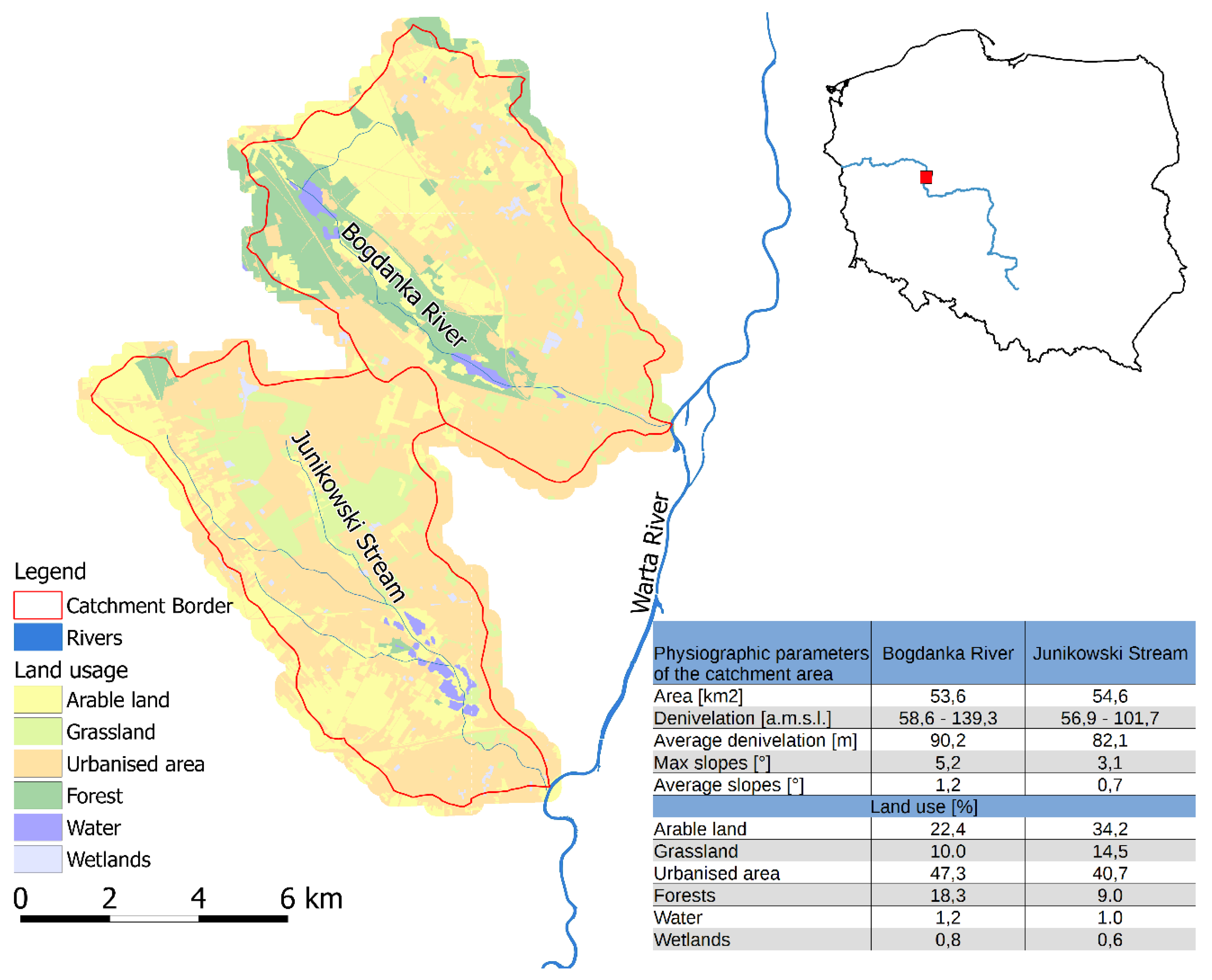
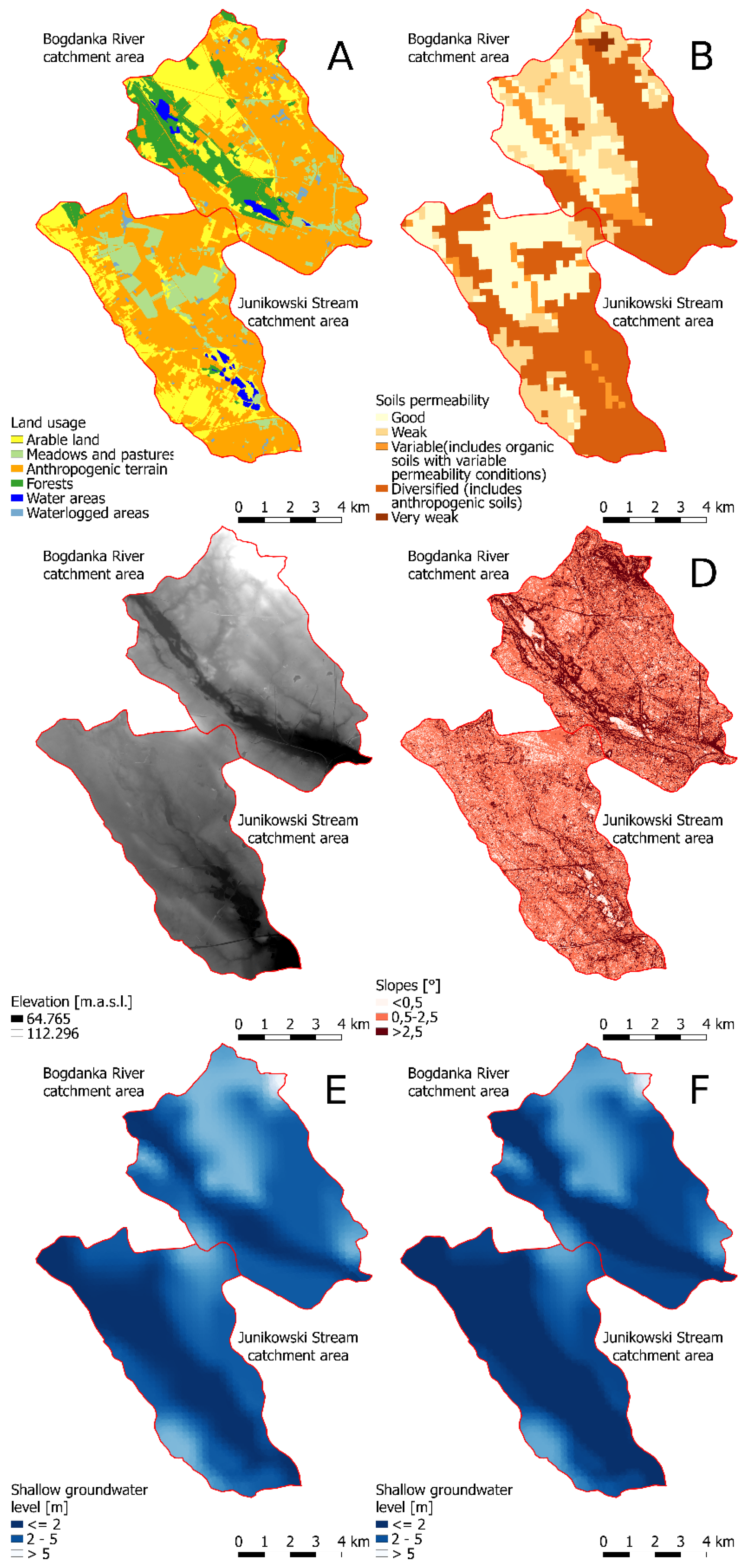
2. Area of Research and Source Material
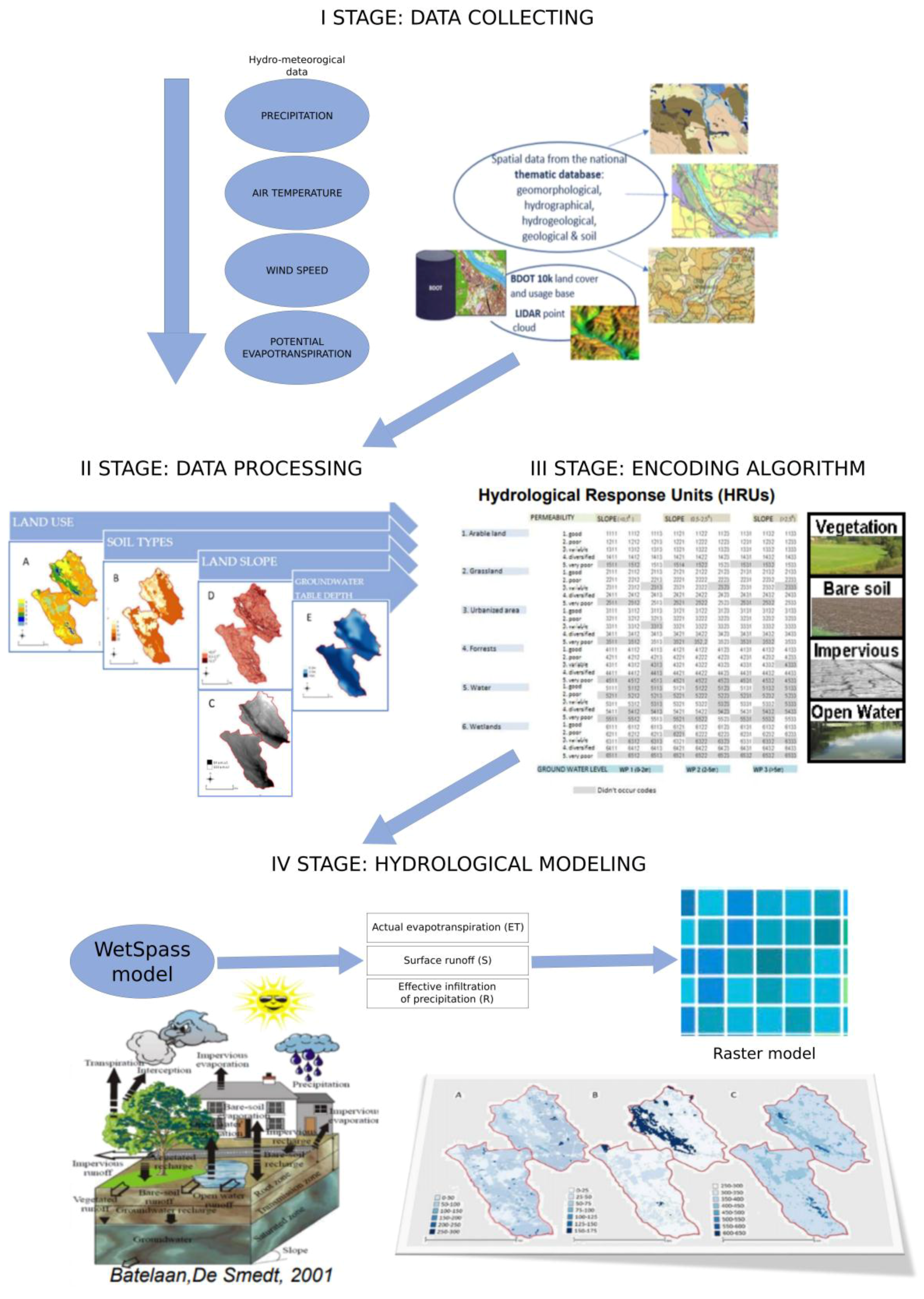
3. Research Methods
- P is the precipitation (mm);
- Hp is the surface outflow (runoff) (mm);
- IE is the infiltrative supply of groundwater (mm);
- IN is the interception (mm);
- TR is the actual transpiration (mm);
- Es is the evaporation from the soil (mm)
- Ew is the evaporation from the water surface (mm);
- En is the evaporation from the impermeable surface (mm); and
- Eta is the actual evapotranspiration (mm).
4. Results and Discussion
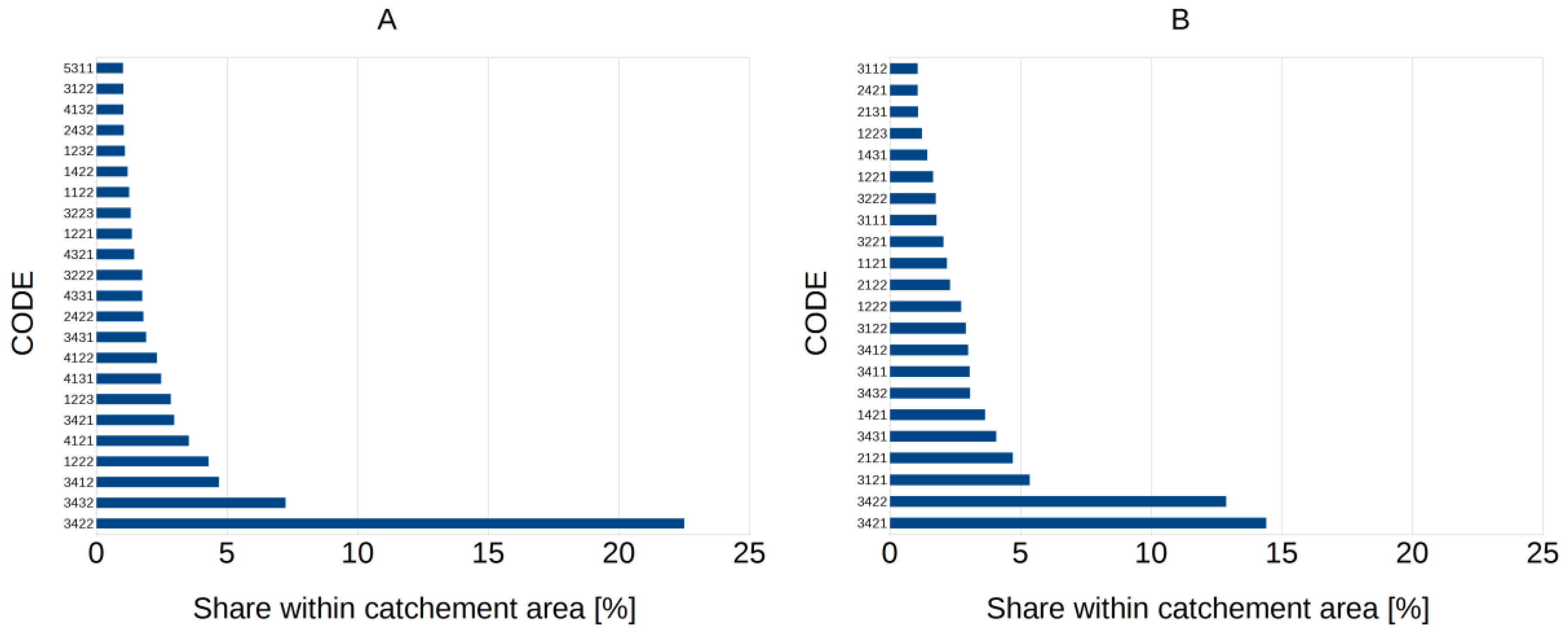
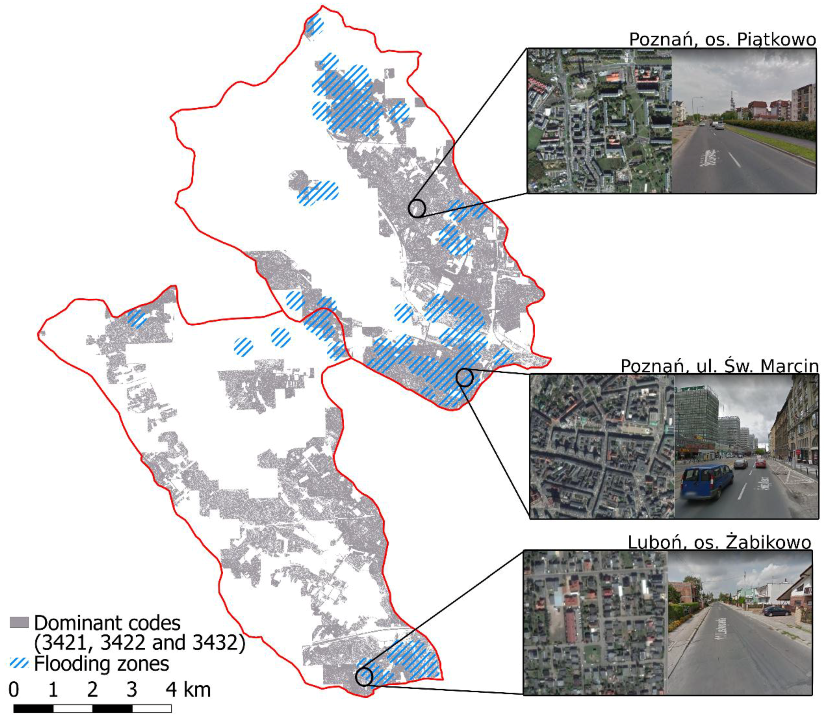
4.1. Dominant HRU Codes
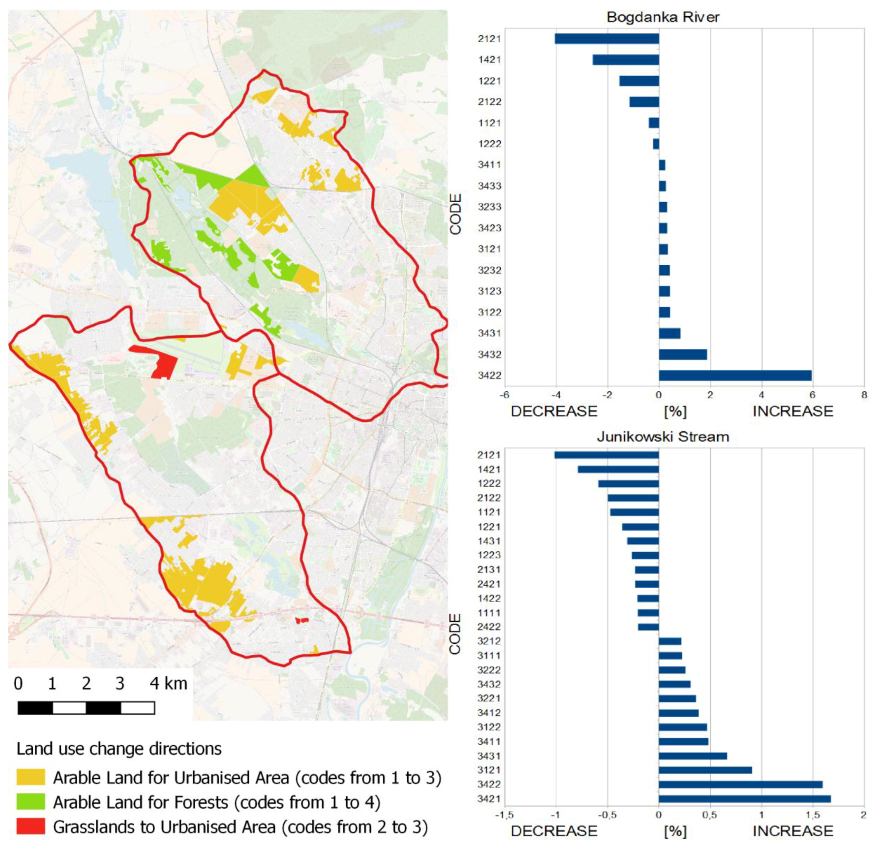
4.2. Changes in Land Use
4.3. Seasonal Analysis of Water Balance Components
4.4. Spatial Analysis of Water Balance Components
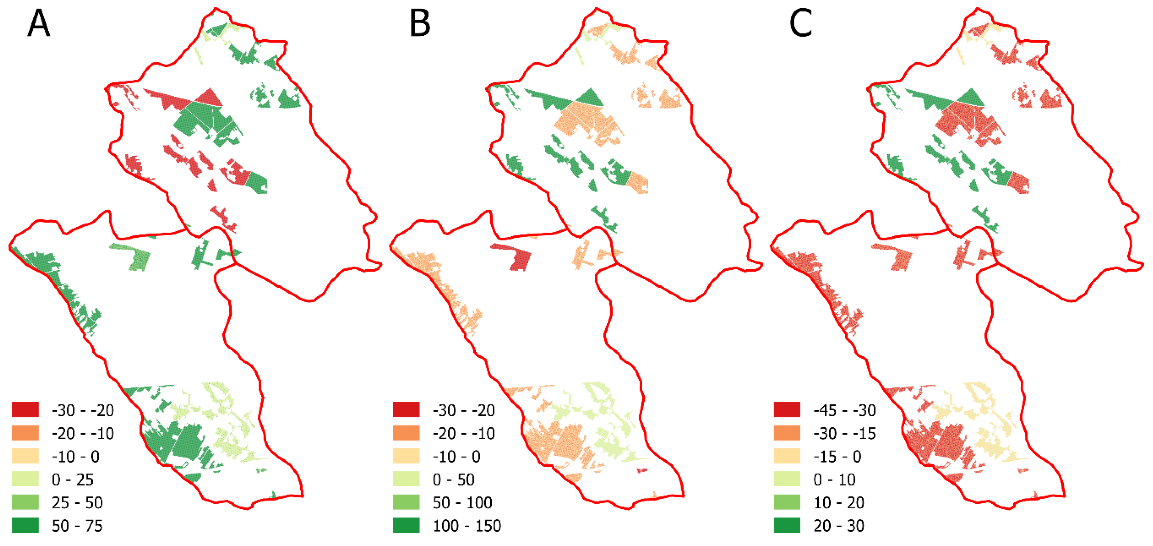
4.5. Changes of Water Balance Components Due to Land Use Changes
4.6. Evaluation of the Quality of the WetSpass Model
4.7. Implications
5. Summary and Conclusions
Author Contributions
Funding
Acknowledgments
Conflicts of Interest
References
- Batelaan, O. Phreatology: Characterizing Groundwater Recharge and Discharge Using Remote Sensing, GIS, Ecology, Hydrochemistry and Groundwater Modeling. Ph.D. Thesis, Vrije Universiteit Brussels, Belgium, 2006; pp. 1–332. [Google Scholar]
- Batelaan, O.; De Smedt, F. WetSpass: A Flexible, GIS Based, Distributed Recharge Methodology for Regional Groundwater Modeling. In Impact of Human Activity on Groundwater Dynamics; Gehrels, H., Peters, J., Hoehn, E., Jensen, K., Leibundgut, C., Griffioen, J., Webb, B., Zaadnoordijk, W.J., Eds.; IAHS: Maastricht, The Netherlands, 2001; Volume 269, pp. 11–17. [Google Scholar]
- Jackson, T.J. Remote Sensing of Soil Moisture: Implications for Groundwater Recharge. Hydrogeol. J. 2002, 10, 40–51. [Google Scholar] [CrossRef]
- Sophocleous, M.A. Groundwater Recharge Estimation and Regionalization: The Great Bend Prairie of Central Kansas and Its Recharge Statistics. J. Hydrol. 1992, 137, 113–140. [Google Scholar] [CrossRef]
- Sophocleous, M.A. Groundwater Recharge and Sustainability in the High Plains Aquifer in Kansas, USA. Hydrogeol. J. 2005, 13, 351–365. [Google Scholar] [CrossRef]
- Thangarajan, M. Groundwater Resource Evaluation, Augmentation, Contamination, Restoration, Modeling and Management; Jointly published with Capital Publishing Company; Springer: Cham, The Netherlands, 2007; Volume 10. [Google Scholar]
- Von Asmuth, J.R.; Maas, C. The Method of Impulse Response Moments: A New Method Integrating Time Series, Groundwater and Eco-Hydrological Modeling. In Impact of Human Activity on Groundwater Dynamics; Geherls, J.C., Peters, N.E., Hoehn, E., Jensen, K., Leibundgut, C., Griffioen, J., Webb, B., Zaadnoordijk, W.J., Eds.; IAHS Publication: Wallingford, UK, 2001; pp. 51–58. [Google Scholar]
- De Boers, D.K. Linking GCMs and Surface Hydrology: The Challenge of Spatial Scale. Can. Geogr. 2001, 45, 79–84. [Google Scholar]
- Dillon, P.; Simmers, I. Shallow Groundwater Systems, IAH International Contributions to Hydrogeology; Taylor and Francis: Rotterdam, The Netherlands, 1998; p. 18. [Google Scholar]
- Schwartz, F.W.; Zhang, H. Fundamentals of Ground Water. Environ. Geol. 2004, 45, 1037–1038. [Google Scholar]
- Sivapalan, M. Pattern, Process and Function: Elements of a Unified Theory of Hydrology at the Catchment Scale. In Encyclopedia of Hydrological Sciences. P. 1. Theory, Organization and Scale; John Wiley & Sons: London, UK, 2005; pp. 193–219. [Google Scholar]
- Sorooshian, S.; Hsu, K.L. Hydrological Modelling and the Water Cycle; Springer: Berlin/Heidelberg, Germany, 2008. [Google Scholar]
- Behzadian, K.; Kapelan, Z. Advantages of Integrated and Sustainability Based Assessment for Metabolism Based Strategic Planning of Urban Water Systems. Sci. Total Environ. 2015, 527, 220–231. [Google Scholar] [CrossRef] [PubMed]
- Graf, R. The Structure and Functioning of Local Groundwater Circulation Systems within the Poznań Plateau; Bogucki Publishing House: Poznań, Poland, 2012. (In Polish) [Google Scholar]
- Gutry-Korycka, M. The Scale in the Mathematical Modelling of Geoecosystems. Glob. Chang. 2002, 9, 11–29. [Google Scholar]
- Lin, H.; Rathbun, S. Hierarchical Frameworks for Multiscale Bridging in Hydropedology. In Scaling Methods in Soil Physics; Pachepsky, Y., Radcliffe, D.E., Selim, H.M., Eds.; CRC Press: Boca Roton, FL, USA, 2003; pp. 347–371. [Google Scholar]
- Long, J.; Nelson, T.; Wulder, M. Regionalization of Landscape Pattern Indices Using Multivariate Cluster Analysis. Environ. Manag. 2010, 46, 134–142. [Google Scholar] [CrossRef] [PubMed]
- Vansteenkiste, T.; Tavakoli, M.; Ntegeka, V.; Willems, P.; De Smedt, F.; Batelaan, O. Climate Change Impact on River Flows and Catchment Hydrology: A Comparison of Two Spatially Distributed Models. Hydrol. Process. 2013, 27, 3649–3662. [Google Scholar] [CrossRef]
- Neitsch, S.L.; Arnold, J.G.; Kiniry, J.R.; Williams, J.R. Soil and Water Assessment Tool. Theoretical Documentation; Springer: Berlin, Germany, 2005. [Google Scholar]
- Neitsch, S.; Arnold, J.G.; Kiniry, J.R.; Williams, J. Soil & Water Assessment Tool Theoretical Documentation Version 2009; Technical Report, No. 406; Texas Water Resources Institute: College Station, TX, USA, 2011. [Google Scholar]
- Graf, R. Spatial Differentiation of Surface Runoff in Urbanised Catchments on the Example of Poznan. In Water in the City; Ciupa, T., Suligowski, R., Eds.; UJK Kielce Publishing House: Kielce, Poland, 2014. (In Polish) [Google Scholar]
- Graf, R.; Kajewski, I. The Forming of the Water Balance Elements in the Mogilnica Catchment Basis of Simulating Investigations. Sci. Nat. Technol. 2013, 7, 1–11. (In Polish) [Google Scholar]
- Graf, R.; Przybyłek, J. Estimation of shallow groundwater recharge using a GIS-based distributed water balance model. Quaest. Geogr. 2014, 33, 27–37. [Google Scholar] [CrossRef]
- Kajewski, I. Assessment of regional water balance components with WetSpass model. Adv. Agric. Sci. Probl. 2008, 528, 63–70. (In Polish) [Google Scholar]
- Pokojska, P. Application and verification of water balance model with distributed parameters (On the example of Rega River Basin). Misc. Geogr. Wars. 2004, 11, 139–149. [Google Scholar]
- Abu-Saleem, A.; Al-Zu’bi, Y.; Rimawi, O.; Al-Zu’bi, J.; Alouran, N. Estimation of water balance components in the Hassa Basin with GIS based WetSpass Model. J. Agron. 2010, 9, 119–125. [Google Scholar]
- Aish, A.M.; Batelaan, O.; De Smedt, F. Distributed recharge estimation for groundwater modeling using Wetspass model, case study—Gaza strip, Palestine. Arabian J. Sci. Eng. 2010, 35, 155–163. [Google Scholar]
- Al Kuisi, M.; El-Naga, A. GIS based spatial groundwater recharge estimation in the Jafr Basin, Jordan—Application of WetSpass models for arid regions. Revista Mexicana de Ciencias Geológicas 2013, 30, 96–109. [Google Scholar]
- Asfaw, M.G. Groundwater Recharge and Water Balance Assessment in Geba Basin, Tigray, Ethiopia. Master’s Thesis, IUPWARE, Vrije Universiteit Brussel, Katholieke Universiteit Leuve, Leuven, Belgium, 2005. [Google Scholar]
- Batelaan, O.; Woldeamlak, S.T. Arcview Interface for WetSpass; Version 13-06-2007; Department of Hydrology and Hydraulic Engineering Vrije University: Brussels, Belgium, 2007. [Google Scholar]
- FAO Penman–Monteith. Crop Evapotranspiration—Guidelines for Computing Crop Water Requirements; FAO Irrigation and Drainage Paper, 56; FAO: Rome, Italy, 1998; Available online: http://www.fao.org/docrep/X0490E/X0490E00.htm (accessed on 10 September 2017).
- Szyga-Pluta, K.; Grześkowiak, K. Pluvial conditions in Poznań in the years 1981–2015. Physiographic research, VII—Series A—Physical Geography (A67). 2016. (In Polish) [Google Scholar] [CrossRef]
- Akan, A.O.; Houghtalen, R.J. Urban Hydrology, Hydraulics, and Stormwater Quality: Engineering Applications and Computer Modeling; Wiley: Hoboken, NJ, USA, 2003. [Google Scholar]
- Cheng, S.; Wang, R. An Approach for Evaluating the hydrological effects of urbanization and its application. Hydrol. Process. 2002, 16, 1403–1418. [Google Scholar] [CrossRef]
- Gutry-Korycka, M. Discharge from Urbanized Catchments. Prace i Studia Geograficzne 2007, 38, 37–56. (In Polish) [Google Scholar]
- Haase, D. Effects of Urbanisation on the water balance—A long-term trajectory. Environ. Impact Assess. Review 2009, 29, 211–219. [Google Scholar] [CrossRef]
- Jokiel, P. Land Development and Its Role in Water Circulation on the Example of a Small Catchment in the Suburban Area of Łódź; Prace Instytutu Geografii AŚ: Kielce, Poland, 2002; Volume 7, pp. 77–86. (In Polish) [Google Scholar]
- Hart, D.J.; Schoephoester, P.R.; Bradbury, K.R. Groundwater recharge in Dane County, Wisconsin: Estimating recharge using a GIS-based water-balance model. Wis. Geol. Nat. Hist. Surv. Bull. 2012, 107, 11. [Google Scholar]
- Teklebirhan, A.; Dessie, N.; Tesfamichael, G. Groundwater recharge, evapotranspiration and surface runoff estimation using wetspass modeling method in Illala catchment, northern Ethiopia. Momona Ethiop. J. Sci. (MEJS) 2012, 4, 96–110. [Google Scholar]
- Żurawski, M. An Attempt to Isolate the Infiltration Types of the Wielkopolska Lowland; Works of the Geographic and Geological Commission; PTPN: Kuala Lumpur, Malaysia, 1966; Volume 6, pp. 1–53. (In Polish) [Google Scholar]
- Jawgiel, K. Application of the VGI Observation in Urban Flash Flood Research on the Example of Poznań. In Proceedings of the Scientific and Technical Conference: Hydrology of the Urban Catchments, Warsaw, Poland, 22–23 September 2016; pp. 115–124, (In Polish). ISSN 0867–7816. [Google Scholar]
- Chiang, W.H.; Kinzelbach, W. 3D-Groundwater Modeling with PMWIN; Springer: Berlin/Heidelberg, Germany; New York, NY, USA, 2001. [Google Scholar]
- Lee, J.G.; Heaney, J.P. Estimation of urban imperviousness and its impacts on storm water systems. J. Water Resour. Plan. Manag. 2003, 129, 419–426. [Google Scholar] [CrossRef]
- Marsh, W.M. Landscape Planning: Environmental Applications; John Wiley & Sons: Hoboken, NJ, USA, 2005. [Google Scholar]
- Krebs, G.; Rimpiläinen, U.M.; Salminen, O. How does imperviousness develop and affect runoff generation in an urbanizing watershed? Fenn.-Intern. J. Geogr. 2013, 191, 143–159. [Google Scholar] [CrossRef]


| Land Usage | Permeability | 1 Slope (<0.5°) | 2 Slope (0.5–2.5°) | 3 Slope (>2.5°) | ||||||
|---|---|---|---|---|---|---|---|---|---|---|
| 1 ARABLE LAND | 1 Good | 1111 | 1112 | 1113 | 1121 | 1122 | 1123 | 1131 | 1132 | 1133 |
| 2 Poor | 1211 | 1212 | 1213 | 1221 | 1222 | 1223 | 1231 | 1232 | 1233 | |
| 3 Variable | 1311 | 1312 | 1313 | 1321 | 1322 | 1323 | 1331 | 1332 | 1333 | |
| 4 Diversified | 1411 | 1412 | 1413 | 1421 | 1422 | 1423 | 1431 | 1432 | 1433 | |
| 5 Very poor | 1511 | 1512 | 1513 | 1521 | 1522 | 1523 | 1531 | 1532 | 1533 | |
| 2 GRASSLAND | 1 Good | 2111 | 2112 | 2113 | 2121 | 2122 | 2123 | 2131 | 2132 | 2133 |
| 2 Poor | 2211 | 2212 | 2213 | 2221 | 2222 | 2223 | 2231 | 2232 | 2233 | |
| 3 Variable | 2311 | 2312 | 2313 | 2321 | 2322 | 2323 | 2331 | 2332 | 2333 | |
| 4 Diversified | 2411 | 2412 | 2413 | 2421 | 2422 | 2423 | 2431 | 2432 | 2433 | |
| 5 Very poor | 2511 | 2512 | 2513 | 2521 | 2522 | 2523 | 2531 | 2532 | 2533 | |
| 3 URBANISED AREA | 1 Good | 3111 | 3112 | 3113 | 3121 | 3122 | 3123 | 3131 | 3132 | 3133 |
| 2 Poor | 3211 | 3212 | 3213 | 3221 | 3222 | 3223 | 3231 | 3232 | 3233 | |
| 3 Variable | 3311 | 3312 | 3313 | 3321 | 3322 | 3323 | 3331 | 3332 | 3333 | |
| 4 Diversified | 3411 | 3412 | 3413 | 3421 | 3422 | 3423 | 3431 | 3432 | 3433 | |
| 5 Very poor | 3511 | 3512 | 3513 | 3521 | 3522 | 3523 | 3531 | 3532 | 3533 | |
| 4 FOREST | 1 Good | 4111 | 4112 | 4113 | 4121 | 4122 | 4123 | 4131 | 4132 | 4133 |
| 2 Poor | 4211 | 4212 | 4213 | 4221 | 4222 | 4223 | 4231 | 4232 | 4233 | |
| 3 Variable | 4311 | 4312 | 4313 | 4321 | 4322 | 4323 | 4331 | 4332 | 4333 | |
| 4 Diversified | 4411 | 4412 | 4413 | 4421 | 4422 | 4423 | 4431 | 4432 | 4433 | |
| 5 Very poor | 4511 | 4512 | 4513 | 4521 | 4522 | 4523 | 4531 | 4532 | 4533 | |
| 5 WATER | 1 Good | 5111 | 5112 | 5113 | 5121 | 5122 | 5123 | 5131 | 5132 | 5133 |
| 2 Poor | 5211 | 5212 | 5213 | 5221 | 5222 | 5223 | 5231 | 5232 | 5233 | |
| 3 Variable | 5311 | 5312 | 5313 | 5321 | 5322 | 5323 | 5331 | 5332 | 5333 | |
| 4 Diversified | 5411 | 5412 | 5413 | 5421 | 5422 | 5423 | 5431 | 5432 | 5433 | |
| 5 Very poor | 5511 | 5512 | 5513 | 5521 | 5522 | 5523 | 5531 | 5532 | 5533 | |
| 6 WETLANDS | 1 Good | 6111 | 6112 | 6113 | 6121 | 6122 | 6123 | 6131 | 6132 | 6133 |
| 2 Poor | 6211 | 6212 | 6213 | 6221 | 6222 | 6223 | 6231 | 6232 | 6233 | |
| 3 Variable | 6311 | 6312 | 6313 | 6321 | 6322 | 6323 | 6331 | 6332 | 6333 | |
| 4 Diversified | 6411 | 6412 | 6413 | 6421 | 6422 | 6423 | 6431 | 6432 | 6433 | |
| 5 Very poor | 6511 | 6512 | 6513 | 6521 | 6522 | 6523 | 6531 | 6532 | 6533 | |
| GROUNDWATER LEVEL | (1) 0–2 m | (2) 2–5 m | (3) >5 m | |||||||
| Codes that were not present in study catchments | ||||||||||
| Base Version | |||||||||||||
| Catchment | Components of the Water Balance | ||||||||||||
| Year | Winter Semi-Annual Period | Summer Semi-Annual Period | |||||||||||
| P * | IE | Hp | ET | P | IE | Hp | ET | P | IE | Hp | ET | ||
| Bogdanka River | (mm) | 529 | 59 | 69 | 405 | 201 | 101 | 27 | 73 | 329 | −42 | 42 | 332 |
| (%) | 100 | 11 | 13 | 76 | 100 | 50 | 14 | 36 | 100 | - | 12 | 101 | |
| Junikowski Stream | (mm) | 528 | 59 | 78 | 394 | 200 | 96 | 30 | 74 | 327 | −37 | 48 | 320 |
| (%) | 100 | 11 | 15 | 74 | 100 | 48 | 15 | 37 | 100 | - | 15 | 98 | |
| + Land Use Changes | |||||||||||||
| Catchment | Components of the Water Balance | ||||||||||||
| Year | Winter Semi-Annual Period | Summer Semi-Annual Period | |||||||||||
| P * | IE | Hp | ET | P | IE | Hp | ET | P | IE | Hp | ET | ||
| Bogdanka River | (mm) | 529 | 54 | 71 | 404 | 201 | 100 | 28 | 73 | 328 | −46 | 43 | 331 |
| (%) | 100 | 10 | 13 | 76 | 100 | 50 | 14 | 36 | 100 | - | 13 | 101 | |
| Junikowski Stream | (mm) | 528 | 55 | 79 | 394 | 200 | 95 | 30 | 74 | 328 | −40 | 49 | 320 |
| (%) | 100 | 10 | 15 | 75 | 100 | 48 | 15 | 37 | 100 | - | 15 | 97 | |
| + Land Use and Climate Changes | |||||||||||||
| Catchment | Components of the Water Balance | ||||||||||||
| Year | Winter Semi-Annual Period | Summer Semi-Annual Period | |||||||||||
| P * | IE | Hp | ET | P | IE | Hp | ET | P | IE | Hp | ET | ||
| Bogdanka River | (mm) | 549 | 65 | 77 | 407 | 207 | 103 | 32 | 72 | 342 | −34 | 44 | 332 |
| (%) | 100 | 12 | 14 | 74 | 100 | 50 | 15 | 35 | 100 | - | 13 | 97 | |
| Junikowski Stream | (mm) | 548 | 66 | 85 | 397 | 208 | 97 | 34 | 76 | 340 | −31 | 51 | 321 |
| (%) | 100 | 12 | 15 | 72 | 100 | 47 | 17 | 37 | 100 | - | 15 | 94 | |
| Components of the Water Balance | Season | Bogdanka River | Junikowski Stream | ||||||||
|---|---|---|---|---|---|---|---|---|---|---|---|
| Min | Max | Range | Mean | σ | Min | Max | Range | Mean | σ | ||
| Surface runoff (HP) | Year | 0.92 | 252.9 | 252.0 | 67.9 | 47 | 0.91 | 208.1 | 207.2 | 76.8 | 55 |
| Winter | 0.11 | 126.1 | 126.0 | 25.2 | 23 | 0.13 | 128.8 | 128.7 | 29.2 | 27 | |
| Summer | 0.00 | 148.2 | 148.2 | 41.6 | 28 | 0.00 | 107.1 | 107.1 | 47.2 | 33 | |
| Effective infiltration (IE) | Year | 0.00 | 163.2 | 163.2 | 57.9 | 35 | 0.00 | 157.7 | 157.7 | 58.7 | 42 |
| Winter | 0.00 | 139.9 | 139.9 | 103.2 | 24 | 0.00 | 138.2 | 138.2 | 97.4 | 27 | |
| Summer | 107.2 | 28.4 | 135.6 | -40.1 | 25 | -107.2 | 26.9 | 134.1 | -34.2 | 31 | |
| Evapotranspiration (ET = E + T + Ic) | Year | 275.2 | 630.1 | 354.9 | 406.1 | 39 | 285.9 | 628.0 | 342.1 | 392.7 | 46 |
| Winter | 60.3 | 91.5 | 31.2 | 72.4 | 5 | 60.2 | 92.7 | 32.5 | 74.1 | 5 | |
| Summer | 200.2 | 554.2 | 354.0 | 331.7 | 40 | 217.5 | 553.6 | 336.1 | 317.9 | 45 | |
| Catchment | Effective Infiltration IE By WetSpass | Underground Inflow | Drainage | Underground Outflow | Inflow Vector Σz | Outflow Vector Σo | Difference |
|---|---|---|---|---|---|---|---|
| Bogdanka River | 58.8 | 32.8 | 89.2 | 2.8 | 91.6 | 92.0 | −0.37 |
| Junikowski Stream | 59.1 | 31.8 | 85.8 | 5.5 | 90.9 | 91.3 | −0.38 |
© 2018 by the authors. Licensee MDPI, Basel, Switzerland. This article is an open access article distributed under the terms and conditions of the Creative Commons Attribution (CC BY) license (http://creativecommons.org/licenses/by/4.0/).
Share and Cite
Graf, R.; Jawgiel, K. The Impact of the Parameterisation of Physiographic Features of Urbanised Catchment Areas on the Spatial Distribution of Components of the Water Balance Using the WetSpass Model. ISPRS Int. J. Geo-Inf. 2018, 7, 278. https://doi.org/10.3390/ijgi7070278
Graf R, Jawgiel K. The Impact of the Parameterisation of Physiographic Features of Urbanised Catchment Areas on the Spatial Distribution of Components of the Water Balance Using the WetSpass Model. ISPRS International Journal of Geo-Information. 2018; 7(7):278. https://doi.org/10.3390/ijgi7070278
Chicago/Turabian StyleGraf, Renata, and Kamil Jawgiel. 2018. "The Impact of the Parameterisation of Physiographic Features of Urbanised Catchment Areas on the Spatial Distribution of Components of the Water Balance Using the WetSpass Model" ISPRS International Journal of Geo-Information 7, no. 7: 278. https://doi.org/10.3390/ijgi7070278
APA StyleGraf, R., & Jawgiel, K. (2018). The Impact of the Parameterisation of Physiographic Features of Urbanised Catchment Areas on the Spatial Distribution of Components of the Water Balance Using the WetSpass Model. ISPRS International Journal of Geo-Information, 7(7), 278. https://doi.org/10.3390/ijgi7070278


