Employing Incremental Outlines for OpenStreetMap Data Updating


Abstract
:1. Introduction
- (1)
- A novel data updating framework, namely an incremental outline-based approach, is proposed for OSM data updating to solve the problem of data inaccuracy and redundancy.
- (2)
- Spatial classification and attribute information are proposed to describe both the spatial and physical changes of the incremental outlines.
- (3)
- Updating operations are designed based on the utilization of incremental outlines to activate the updating process of the OSM data.
2. Methodology
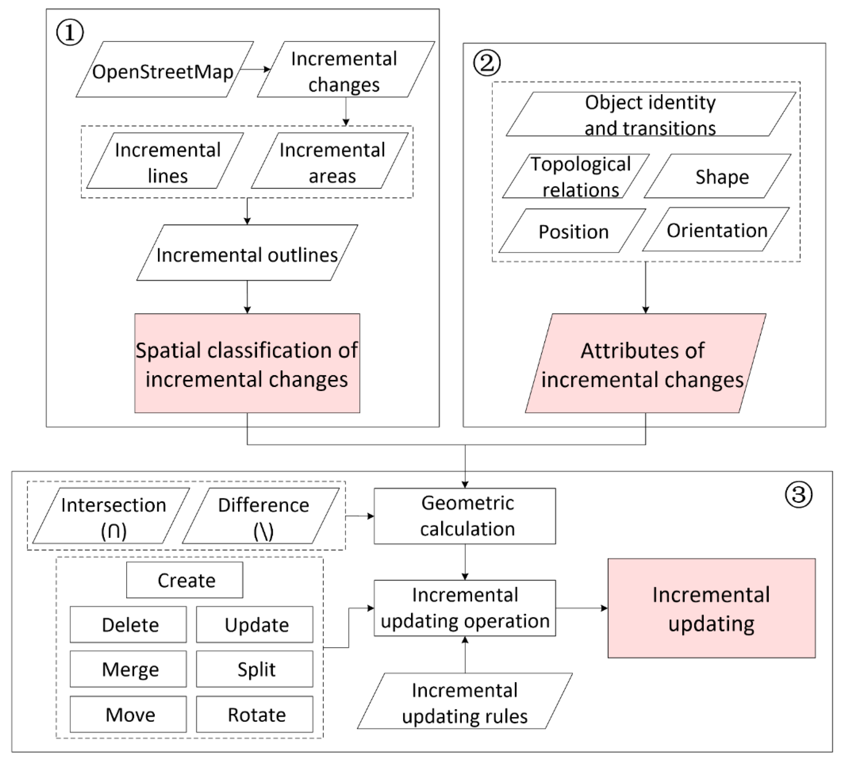
2.1. Overview
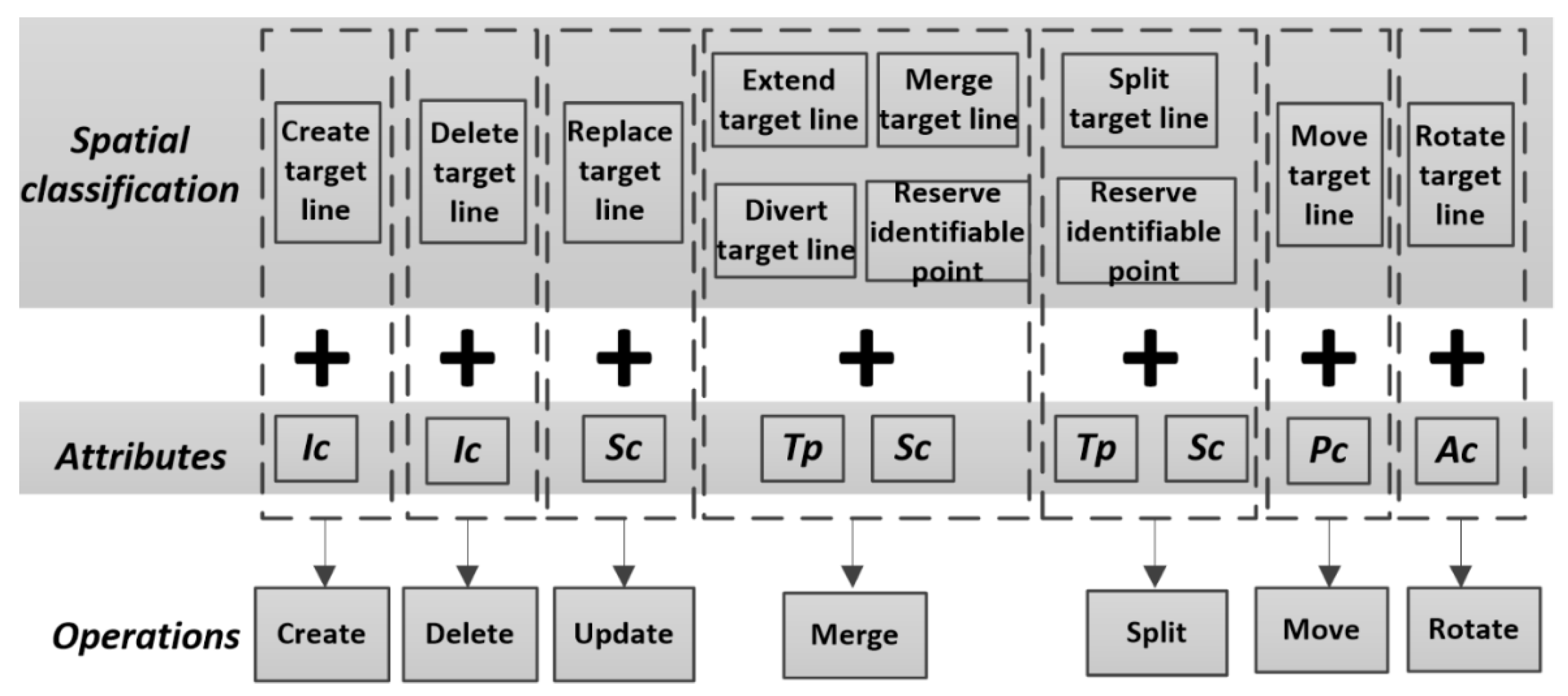
2.2. Spatial Classification of Incremental Changes
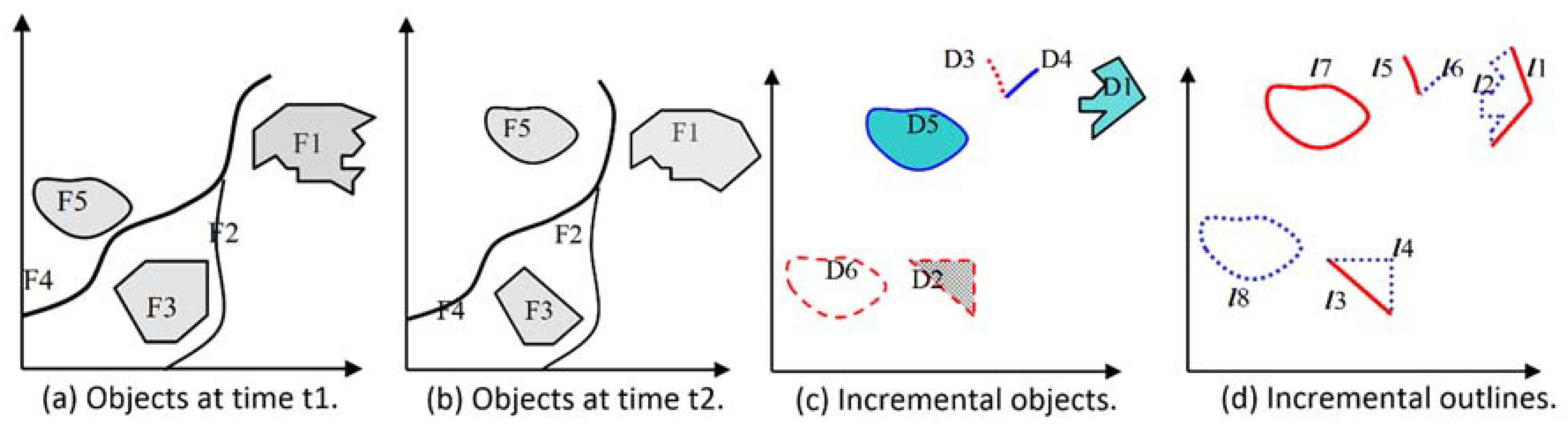
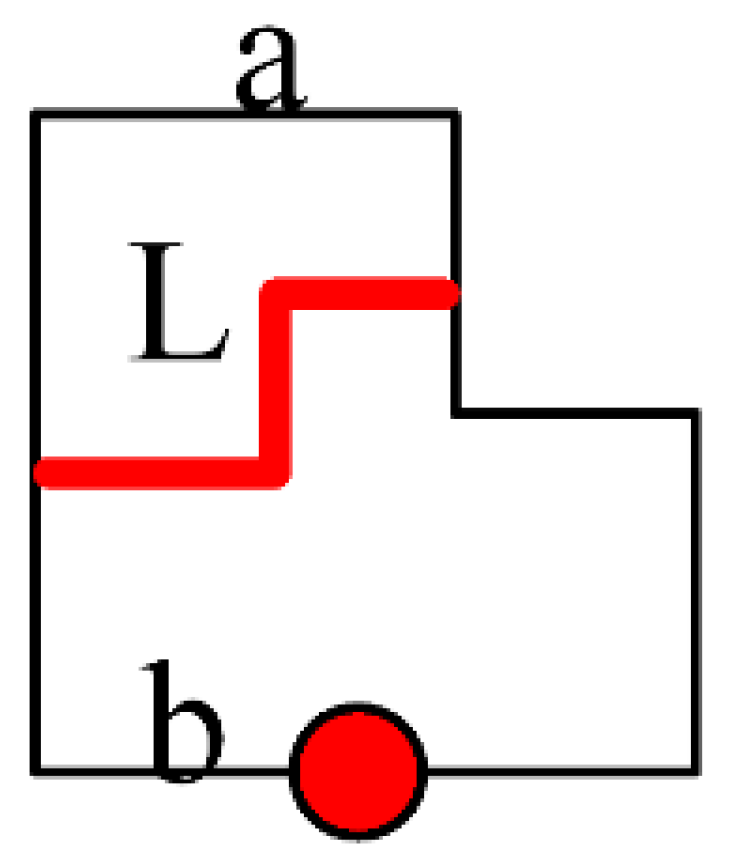
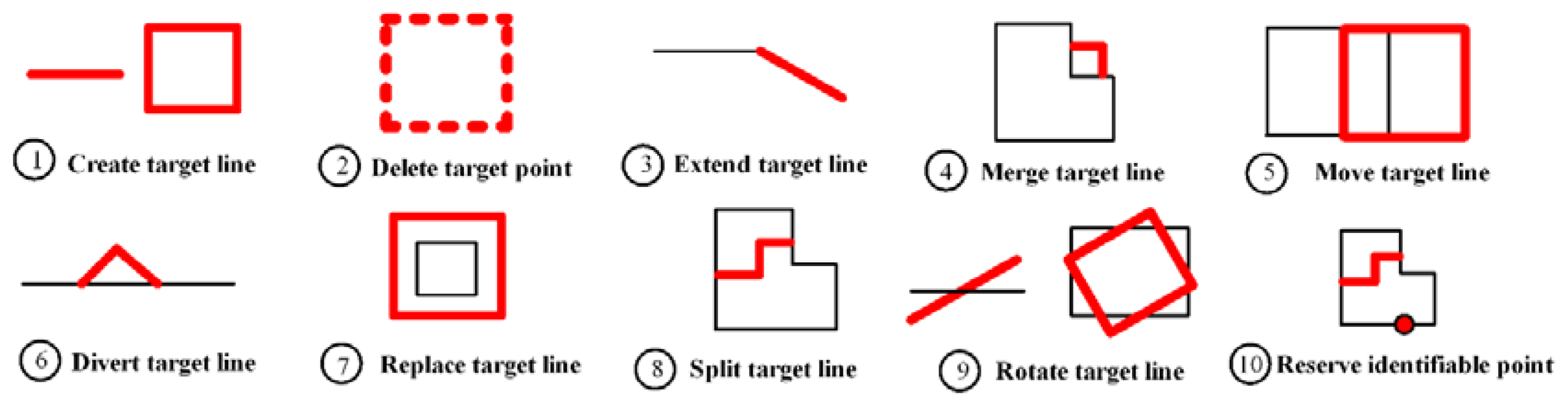
2.2.1. Introduction of the Incremental Outlines
2.2.2. Spatial Classification of Incremental Changes Based on Incremental Outlines
2.3. Attributes of Incremental Changes
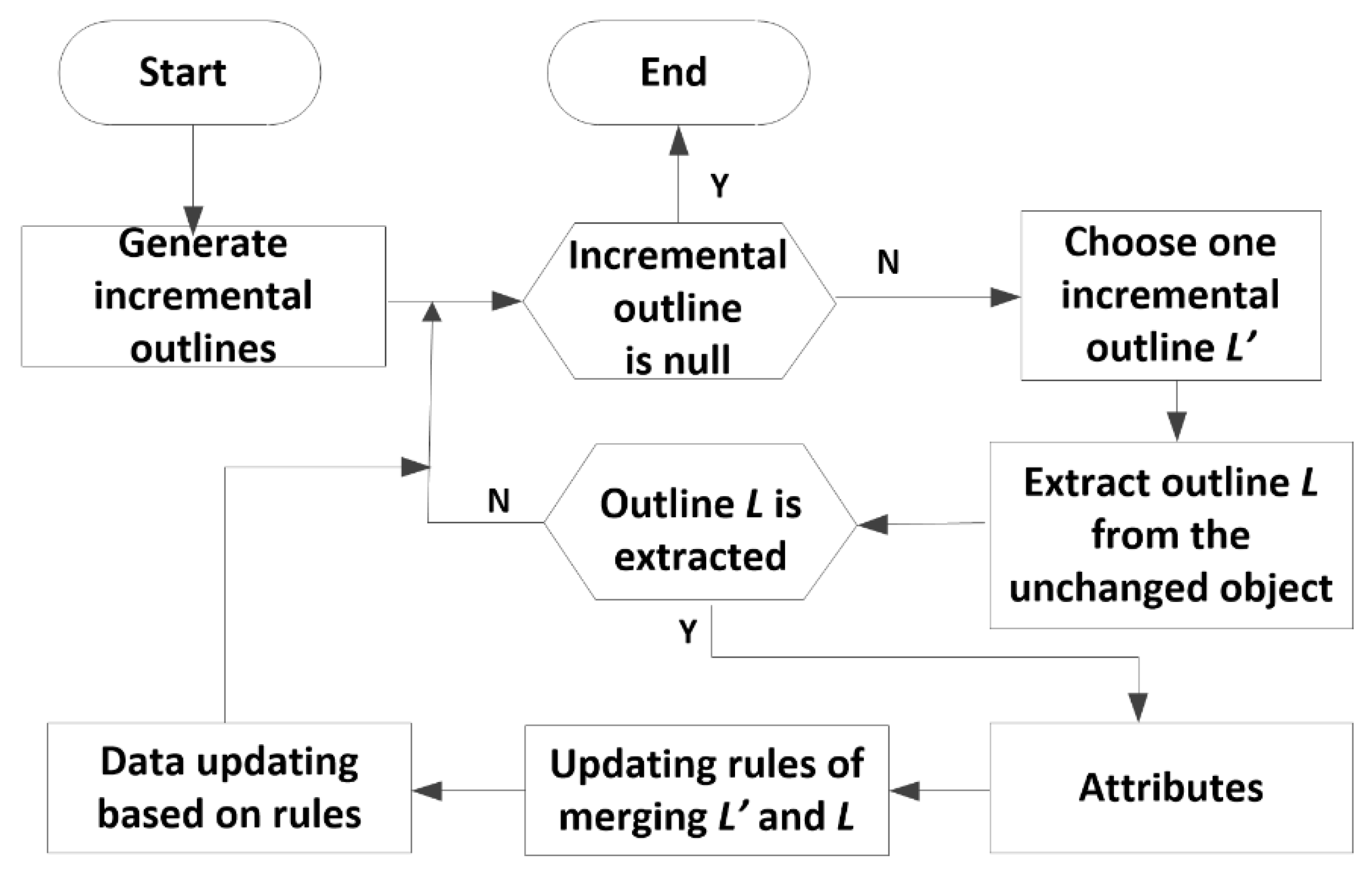
2.4. Incremental Updating Using Incremental Outlines
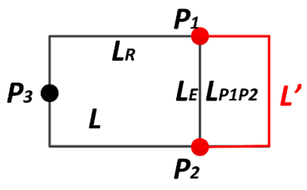
2.4.1. Geometric Calculation Based on Incremental Outlines
- Extend target line: ,
- Split target line: ,
- Merge target line: ,
- Divert target line: ,
- Replace target line: ,
2.4.2. Incremental Updating Operations
2.4.3. Construction of Incremental Updating Rules
3. Results
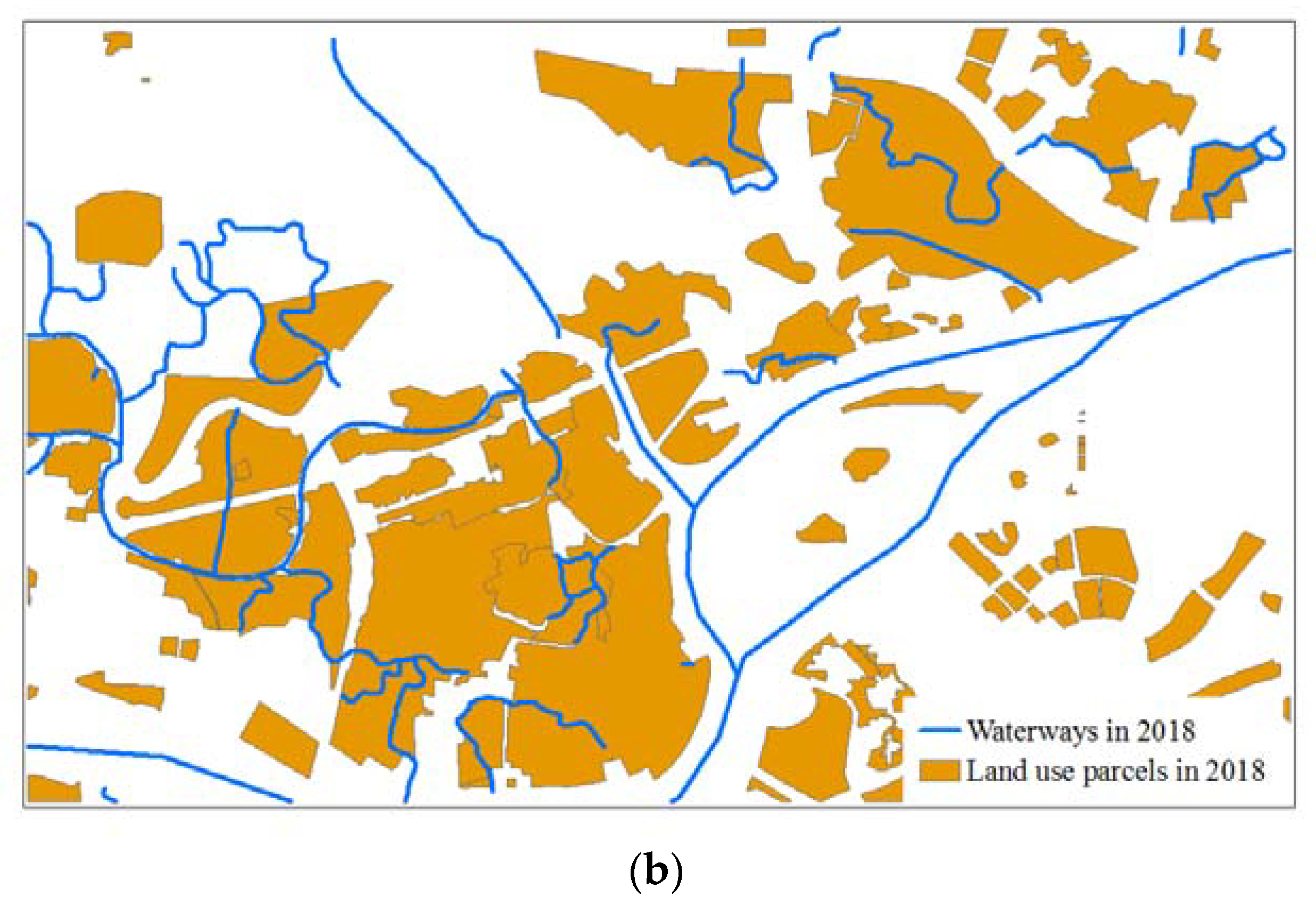
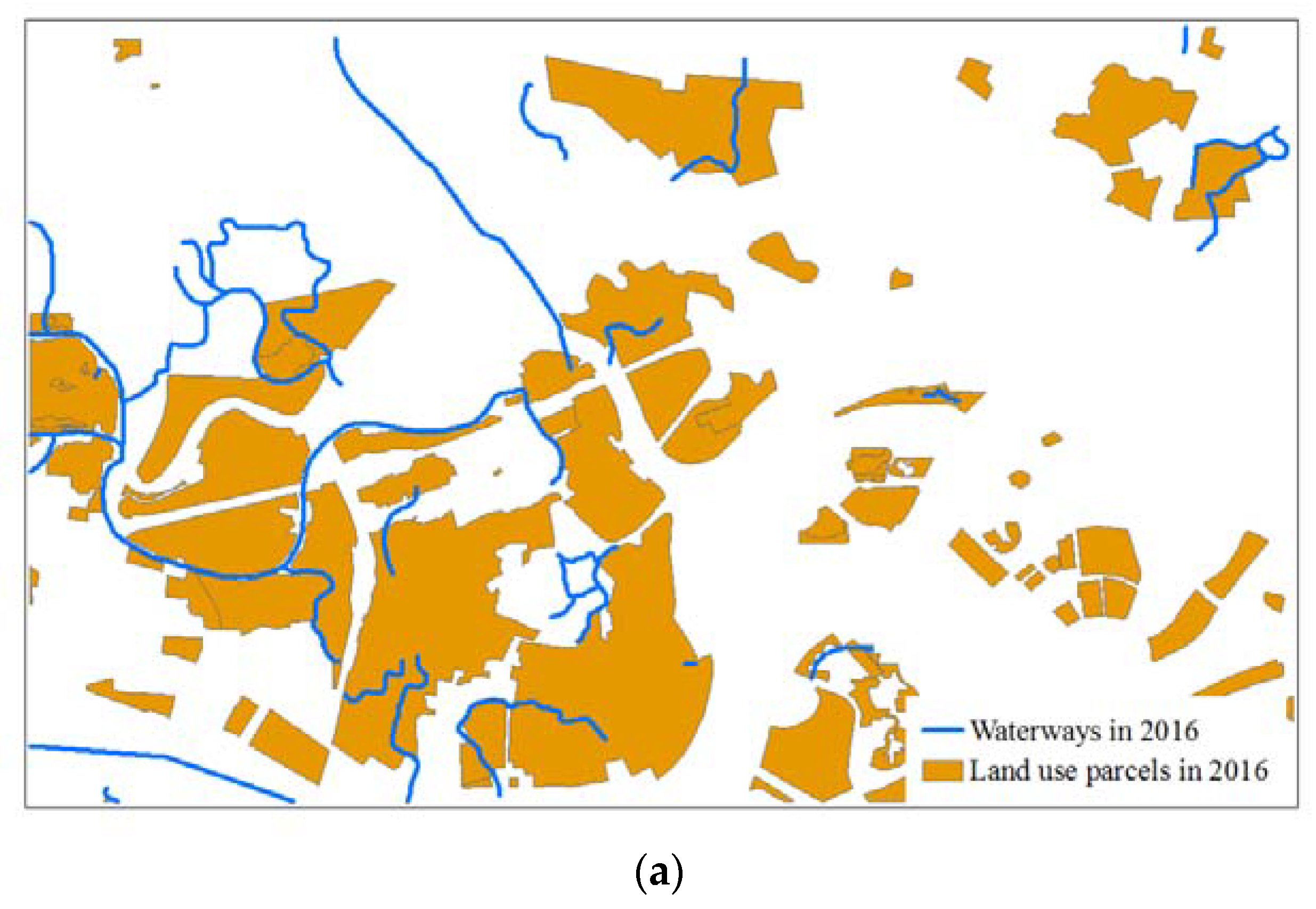
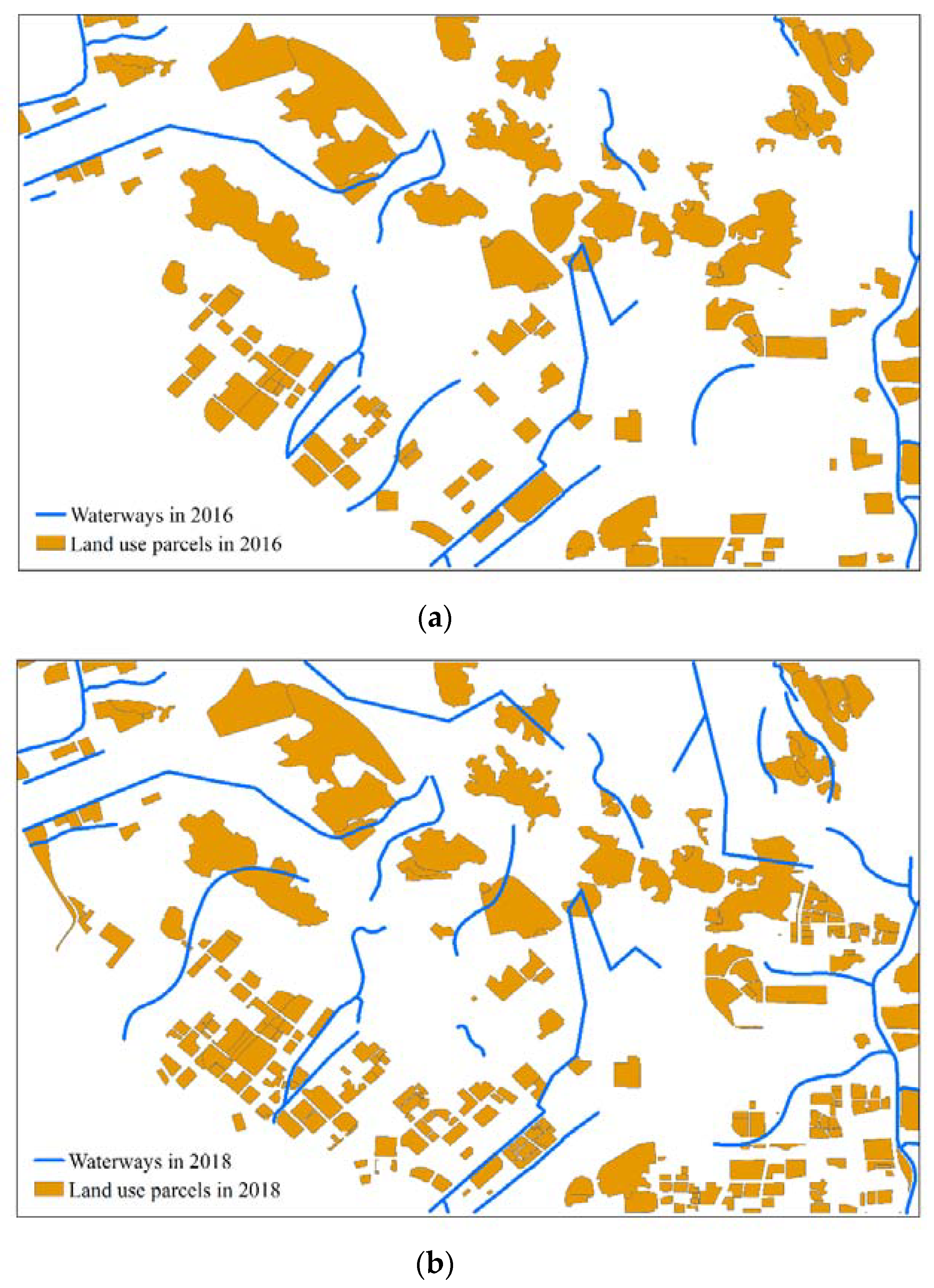
3.1. Experimental Data
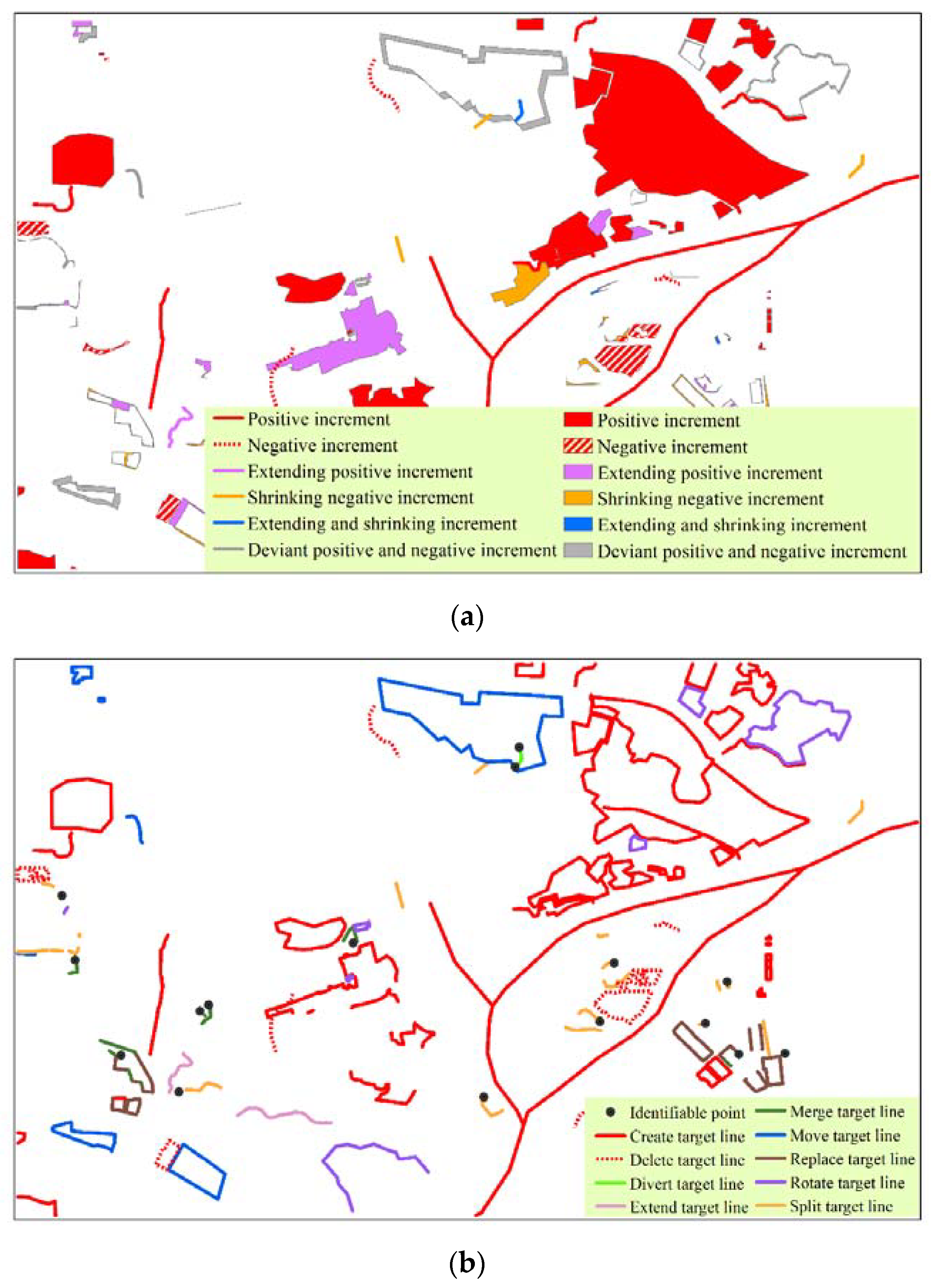
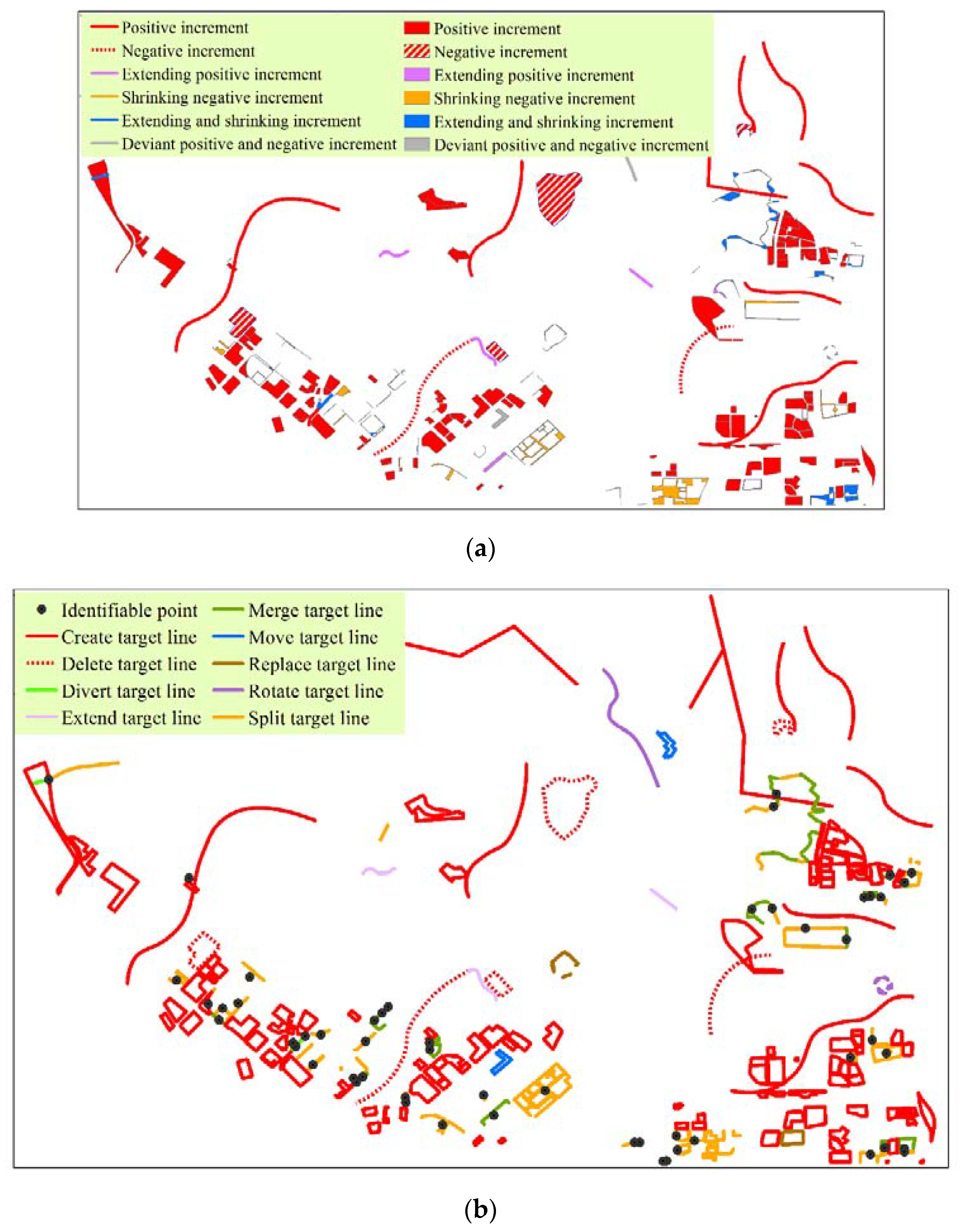
3.2. Incremental Updating for OpenStreetMap
4. Discussion and Conclusions
Author Contributions
Funding
Acknowledgments
Conflicts of Interest
References
- Goodchild, M.F. Citizens as voluntary sensors: Spatial data infrastructure in the world of web 2.0. Int. J. Spat. Data Infrastruct. Res. 2010, 2, 24–32. [Google Scholar]
- Haklay, M.; Weber, P. OpenStreetMap: User-generated street maps. IEEE Perv. Comput. 2008, 7, 12–18. [Google Scholar] [CrossRef]
- Estima, J.; Painho, M. Exploratory Analysis of OpenStreetMap for Land Use Classification. In Proceedings of the Second ACM SIGSPATIAL International Workshop on Crowdsourced and Volunteered Geographic Information, Orlando, FL, USA, 5 November 2013; pp. 39–46. [Google Scholar]
- Liu, X.; Long, Y. Automated identification and characterization of parcels with OpenStreetMap and points of interest. Environ. Plan. B Plan. Des. 2016, 43, 341–360. [Google Scholar] [CrossRef]
- Fonte, C.C.; Martinho, N. Assessing the applicability of OpenStreetMap data to assist the validation of land use/land cover maps. Int. J. Geogr. Inf. Sci. 2017, 31, 2382–2400. [Google Scholar] [CrossRef]
- Ali, A.L.; Falomir, Z.; Schmid, F.; Freksa, C. Rule-guided human classification of volunteered geographic information. ISPRS J. Photogramm. Remote Sens. 2017, 127, 3–15. [Google Scholar] [CrossRef]
- Hashemi, P.; Abbaspour, R.A. Assessment of logical consistency in OpenStreetMap based on the spatial similarity concept. In OpenStreetMap in GIScience; Springer: Berlin, Germany, 2015; pp. 19–36. [Google Scholar]
- Mooney, P.; Corcoran, P.; Winstanley, A.C. Towards quality metrics for OpenStreetMap. In Proceedings of the 18th SIGSPATIAL International Conference on Advances in Geographic Information Systems, San Jose, CA, USA, 2–5 November 2010; pp. 514–517. [Google Scholar]
- Fan, H.; Zipf, A.; Fu, Q.; Neis, P. Quality assessment for building footprints data on OpenStreetMap. Int. J. Geogr. Inf. Sci. 2014, 28, 700–719. [Google Scholar] [CrossRef]
- Fan, H.; Yang, A.; Zipf, A. The intrinsic quality assessment of building footprints data on OpenStreetMap in baden-württemberg. In Flächennutzungsmonitoring VIII Flächensparen-Ökosystemleistungen-Handlungsstrategien; RHOMBOS: Berlin, Germany, 2016; pp. 253–260. [Google Scholar]
- Girres, J.F.; Touya, G. Quality assessment of the French OpenStreetMap dataset. Trans. GIS 2010, 14, 435–459. [Google Scholar] [CrossRef]
- Yang, A.; Fan, H.; Jing, N.; Sun, Y.; Zipf, A. Temporal analysis on contribution inequality in OpenStreetMap: A comparative study for four countries. ISPRS Int. J. Geo-Inf. 2016, 5, 5. [Google Scholar] [CrossRef]
- Shen, J.; Yang, S.; Zang, K.; Zhou, J.; Fan, H.; Mao, B. The opinion of crowd participatory for OpenStreetMap: A survey in china. Int. Arch. Photogramm. Remote Sens. Spat. Inf. Sci. 2018, 42, 1525–1531. [Google Scholar] [CrossRef]
- Hagenauer, J.; Helbich, M. Mining urban land-use patterns from volunteered geographic information by means of genetic algorithms and artificial neural networks. Int. J. Geogr. Inf. Sci. 2012, 26, 963–982. [Google Scholar] [CrossRef]
- Zhao, Y.; Zhou, X.; Li, G.; Xing, H. A spatio-temporal VGI model considering trust-related information. ISPRS Int. J. Geo-Inf. 2016, 5, 10. [Google Scholar] [CrossRef]
- Yang, A.; Fan, H.; Jing, N. Amateur or professional: Assessing the expertise of major contributors in OpenStreetMap based on contributing behaviors. ISPRS Int. J. Geo-Inf. 2016, 5, 21. [Google Scholar] [CrossRef]
- Fonte, C.C.; Bastin, L.; See, L.; Foody, G.; Lupia, F. Usability of VGI for validation of land cover maps. Int. J. Geogr. Inf. Sci. 2015, 29, 1269–1291. [Google Scholar] [CrossRef]
- Spéry, L.; Claramunt, C.; Libourel, T. A spatio-temporal model for the manipulation of lineage metadata. Geoinformatica 2001, 5, 51–70. [Google Scholar] [CrossRef]
- Claramunt, C.; Theriault, M. Toward semantics for modelling spatio-temporal processes within GIS. Adv. GIS Res. I 1996, 27–43. [Google Scholar]
- Xing, H.; Chen, J.; Changhui, L.I. Design and implementation of network marking and reporting system of topographic feature change information. Geomat. World 2013, 5, 59–63. [Google Scholar]
- Zhu, H.; Wu, H. Description and representation model of spatial object incremental update. J. Spat. Sci. 2014, 59, 47–61. [Google Scholar] [CrossRef]
- Claramunt, C.; Thériault, M. Managing time in GIS an event-oriented approach. In Recent Advances in Temporal Databases; Springer: Berlin, Germany, 1995; pp. 23–42. [Google Scholar]
- Hornsby, K.; Egenhofer, M.J. Identity-based change: A foundation for spatio-temporal knowledge representation. Int. J. Geogr. Inf. Sci. 2000, 14, 207–224. [Google Scholar] [CrossRef]
- Chen, J.; Zhou, X. Incremental updating of spatial database based on topological linkage, taking cadastral database’s updating as an example. Acta Geod. Cartogr. Sin. 2008, 37, 321–329. [Google Scholar]
- Li, P.; Wang, H. Automatic recognition of change types of residential areas using topology relations model. Geomat. Inf. Sci. Wuhan Univ. 2009, 3, 12. [Google Scholar]
- Zhou, X.-G.; Chen, J.; Zhan, F.B.; Li, Z.; Madden, M.; Zhao, R.-L.; Liu, W.-Z. A Euler number-based topological computation model for land parcel database updating. Int. J. Geogr. Inf. Sci. 2013, 27, 1983–2005. [Google Scholar] [CrossRef]
- Xing, H.; Chen, J.; Li, C.; Zhou, X. Parametric approach to classification of spatial object change. J. Cent. South Univ. 2014, 45, 495–500. [Google Scholar]
- Wang, Y.; Zhang, Q.; Guan, H. Incrementally detecting change types of spatial area object: A hierarchical matching method considering change process. ISPRS Int. J. Geo-Inf. 2018, 7, 42. [Google Scholar] [CrossRef]
- Fan, Y.; Yang, J.; Zhang, C.; Zhu, D. A event-based change detection method of cadastral database incremental updating. Math. Comput. Model. 2010, 51, 1343–1350. [Google Scholar] [CrossRef]
- Harrie, L. Generalisation Methods for Propagating Updates between Cartographic Data Sets; Department of Physical Geography and Ecosystem Science: Lund, Sweden, 1998. [Google Scholar]
- Chen, J.; Lin, Y.; Liu, W. Formal classification of spatial incremental changes for updating. Acta Geod. Cartogr. Sin. 2012, 41, 108–114. [Google Scholar]
- Badard, T.; Richard, D. Using xml for the exchange of updating information between geographical information systems. Comput. Environ. Urban Syst. 2001, 25, 17–31. [Google Scholar] [CrossRef]
- Zhang, X.; Guo, T.; Huang, J.; Xin, Q. Propagating updates of residential areas in multi-representation databases using constrained Delaunay triangulations. ISPRS Int. J. Geo-Inf. 2016, 5, 80. [Google Scholar] [CrossRef]
- Egenhofer, M.J.; Al-Taha, K.K. Reasoning about gradual changes of topological relationships. In Theories and Methods of Spatio-Temporal Reasoning in Geographic Space; Springer: Berlin, Germany, 1992; pp. 196–219. [Google Scholar]
- Zhao, Z.; Stough, R.R.; Song, D. Measuring congruence of spatial objects. Int. J. Geogr. Inf. Sci. 2011, 25, 113–130. [Google Scholar] [CrossRef]
- Khoshafian, S.N.; Copeland, G.P. Object Identity; ACM: New York, NY, USA, 1986; Volume 21. [Google Scholar]
- Li, Z.; Zhao, R.; Chen, J. A Voronoi-based spatial algebra for spatial relations. Prog. Nat. Sci.-Mater. Int. 2002, 12, 528–536. [Google Scholar]
- Xing, H. Models of spatial marking and reporting for geographic updating. Acta Geod. Cartogr. Sin. 2014, 43, 880. [Google Scholar]
- Beyen, J.; Henrion, J. Updating topographic databases with arc info; client-fitted creation of change-only information. In International Archives of Photogrammetry and Remote Sensing; Citeseer: Stuttgart, Germany, 1998. [Google Scholar]
- Badard, T. On the automatic retrieval of updates in geographic databases based on geographic data matching tools. Bulletin Comité Français Cartographie 1999, 162, 34–40. [Google Scholar]
- Zhou, X.; Chen, J.; Madden, M. Classification and identification of cadastral structure change. Int. Arch. Photogramm. Remote Sens. Spat. Inf. Sci. 2008, 37, 1437–1446. [Google Scholar]
- Chen, J.; Chen, J.; Liao, A.; Cao, X.; Chen, L.; Chen, X.; He, C.; Han, G.; Peng, S.; Lu, M. Global land cover mapping at 30 m resolution: A POK-based operational approach. ISPRS J. Photogramm. Remote Sens. 2015, 103, 7–27. [Google Scholar] [CrossRef]


| Incremental Types | Incremental Objects | Incremental Outlines | Legends |
|---|---|---|---|
| Incremental Lines | Positive increments |  Create target line |  Appearance of line |
| Negative increments |  Delete target line |  Vanishing of line | |
| Deviant positive and negative increments |  Move target line |  Movement of line, objects disjoint | |
 Rotate target line |  Rotation of line | ||
| Extending positive increments |  Extend target line |  Extending of line | |
| Shrinking negative increments |  Split target line |  Shrinking of line | |
| Extending and shrinking increments |  Divert target line |  Partial changes of line | |
 Move target line |  Movement of line, objects intersect |
| Incremental Types | Incremental Objects | Incremental Outlines | Legends |
|---|---|---|---|
| Incremental areas | Positive increments |  Create target line |  Appearance of area |
| Negative increments |  Delete target line |  Vanishing of area | |
| Deviant positive and negative increments |  Move target line |  Movement of area, objects disjoint | |
| Extending positive increments |  Replace target line |  Expanding of area | |
 Expand target line |  Partial expanding of area | ||
| Shrinking negative increments |  Replace target line |  Shrinking of area | |
 Split target line |  Partial shrinking of area | ||
| Extending and shrinking increments |  Move target line |  Movement of area, objects intersect | |
 Rotate target line |  Rotation of area |
| Incremental Type | Before Changes | After Changes | Incremental Objects | Incremental Outlines | Attributes |
|---|---|---|---|---|---|
| Positive increments |  |  |  |  | Topological relations |
 |  |  |  | Topological relations |
| Incremental Changes | Experimental Area #1 | Experimental Area #2 | |
|---|---|---|---|
| Incremental objects classification | Positive increment | 44 | 130 |
| Negative increment | 14 | 10 | |
| Extending positive increment | 30 | 13 | |
| Shrinking negative increment | 28 | 18 | |
| Extending and shrinking increment | 4 | 40 | |
| Deviant positive and negative increment | 18 | 8 | |
| Incremental outlines classification | Create target line | 45 | 128 |
| Delete target line | 11 | 10 | |
| Divert target line | 1 | 4 | |
| Extend target line | 3 | 3 | |
| Merge target line | 7 | 25 | |
| Move target line | 7 | 5 | |
| Replace target line | 9 | 3 | |
| Rotate target line | 7 | 3 | |
| Split target line | 12 | 29 | |
| Incremental Types | Numbers of Incremental Changes | Time Costs for Updating | Storage for Updating | |
|---|---|---|---|---|
| Experimental Area #1 | Incremental objects | 138 incremental objects | 1.2 s | 98.0 KB |
| Incremental outlines | 102 incremental outlines | 0.4 s | 54.8 KB | |
| Experimental Area #2 | Incremental objects | 219 incremental objects | 2.6 s | 126.8 KB |
| Incremental outlines | 210 incremental outlines | 0.9 s | 81.2 KB |
© 2018 by the authors. Licensee MDPI, Basel, Switzerland. This article is an open access article distributed under the terms and conditions of the Creative Commons Attribution (CC BY) license (http://creativecommons.org/licenses/by/4.0/).
Share and Cite
Xing, H.; Meng, Y.; Chen, J.; Song, J.; Fan, K. Employing Incremental Outlines for OpenStreetMap Data Updating. ISPRS Int. J. Geo-Inf. 2018, 7, 277. https://doi.org/10.3390/ijgi7070277
Xing H, Meng Y, Chen J, Song J, Fan K. Employing Incremental Outlines for OpenStreetMap Data Updating. ISPRS International Journal of Geo-Information. 2018; 7(7):277. https://doi.org/10.3390/ijgi7070277
Chicago/Turabian StyleXing, Hanfa, Yuan Meng, Jun Chen, Jie Song, and Kaixuan Fan. 2018. "Employing Incremental Outlines for OpenStreetMap Data Updating" ISPRS International Journal of Geo-Information 7, no. 7: 277. https://doi.org/10.3390/ijgi7070277
APA StyleXing, H., Meng, Y., Chen, J., Song, J., & Fan, K. (2018). Employing Incremental Outlines for OpenStreetMap Data Updating. ISPRS International Journal of Geo-Information, 7(7), 277. https://doi.org/10.3390/ijgi7070277