Geospatial Analysis and the Internet of Things


Abstract
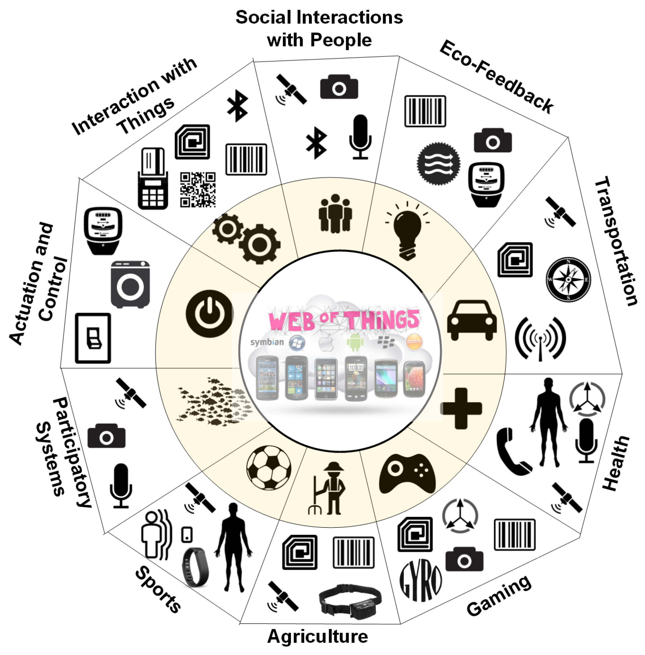
:1. Locating the Internet of Things
- What is the role of IoT in geospatial research at the moment with respect to analysis methods, applications, and geographic scales?
- What are the IoT characteristics with respect to location and geospatial data, i.e., device/data types, reliability and accuracy, security and privacy, device settings and deployment aspects?
- What are the challenges and opportunities of using IoT for geospatial research in the future?
2. Methodology
- Used an IoT infrastructure applied in some real-world application.
- Used some geospatial analytical method or technique based on GIS, in order to address some geospace-related problem.
3. Analytical Methods and Applications
3.1. Geometric Measures
3.2. Basic Analytical Operations
3.3. Basic Analytical Methods
3.4. Network Analysis
3.5. Data Mining
3.6. Analysis of Surfaces and Geostatistics
3.7. Discussion of Analysis Methods
4. IoT for Geospatial Research
4.1. IoT Devices and Sensors
4.2. Mobile vs. Static IoT Devices
4.3. IoT Data Transmission Standards
4.4. Data Sources and Types
4.5. Data Sharing and Interoperability
4.6. Scope of Analysis
4.7. Reliability
4.8. Security and Privacy
5. The Future of Geospatial Analysis and IoT
5.1. Challenges
5.2. Projections for the Future
6. Conclusions
Author Contributions
Funding
Conflicts of Interest
References
- Gershenfeld, N.; Krikorian, R.; Cohen, D. The internet of things. Sci. Am. 2004, 291, 76–81. [Google Scholar] [CrossRef] [PubMed]
- Kamilaris, A.; Pitsillides, A.; Yiallouros, M. Building energy-aware smart homes using web technologies. J. Ambient Intell. Smart Environ. 2013, 5, 161–186. [Google Scholar]
- Kamilaris, A.; Pitsillides, A.; Prenafeta-Boldu, F.; AlI, M. A web of things based eco-system for urban computing—Towards smarter cities. In Proceedings of the 24th International Conference on Telecommunications (ICT), Limassol, Cyprus, 3–5 May 2017. [Google Scholar]
- Kamilaris, A.; Gao, F.; Prenafeta-Boldu, F.; Ali, M. Agri-IoT: A semantic framework for Internet of Things-enabled smart farming applications. In Proceedings of the IEEE World Forum on Internet of Things (WF-IoT), Reston, VA, USA, 12–14 December 2016. [Google Scholar]
- Lane, N.; Miluzzo, E.; Lu, H.; Peebles, D.; Choudhury, T.; Campbell, A. A survey of mobile phone sensing. IEEE Commun. Mag. 2010, 48. [Google Scholar] [CrossRef]
- Wilde, E.; Kofahl, M. The locative web. In Proceedings of the First International Workshop on Location and the Web (LOCWEB ’08), Beijing, China, 22 April 2008; pp. 1–8. [Google Scholar]
- Ereth, J. Geospatial Analytics in the Internet of Things. 2018. Available online: https://www.eckerson.com/articles/geospatial-analytics-in-the-internet-of-things (accessed on 5 July 2018).
- Bisio, R. How Spatial Data Adds Value to the Internet of Things. 2018. Available online: http://internetofthingsagenda.techtarget.com/blog/IoT-Agenda/How-spatial-data-adds-value-to-the-internet-of-things (accessed on 5 July 2018).
- Kamilaris, A.; Pitsillides, A. Mobile phone computing and the Internet of Things: A survey. IEEE Internet Things (IoT) J. 2016, 3, 885–898. [Google Scholar] [CrossRef]
- Zeimpekis, V.; Giaglis, G.; Lekakos, G. A taxonomy of indoor and outdoor positioning techniques for mobile location services. ACM SIGecom Exch. 2002, 3, 19–27. [Google Scholar] [CrossRef] [Green Version]
- Kamilaris, A.; Kartakoullis, A.; Prenafeta-Boldú, F. A review on the practice of big data analysis in agriculture. Comput. Electron. Agric. Int. J. 2017, 143, 23–37. [Google Scholar] [CrossRef]
- Puiu, D.; Barnaghi, P.; Tönjes, R.; Kümper, D.; Ali, M.I.; Mileo, A.; Parreira, J.X.; Fischer, M.; Kolozali, S.; Farajidavar, N.; et al. Citypulse: Large scale data analytics framework for smart cities. IEEE Access 2016, 4, 1086–1108. [Google Scholar] [CrossRef]
- Kamilaris, A.; Pitsillides, A. The impact of remote sensing on the everyday lives of mobile users in urban areas. In Proceedings of the 7th International Conference on Mobile Computing and Ubiquitous Networking 2014 (ICMU2014), Singapore, 6–8 January 2014. [Google Scholar]
- Kamilaris, A.; Iannarilli, N.; Trifa, V.; Pitsillides, A. Bridging the mobile web and the web of things in urban unvironments. In Proceedings of the First International Workshop the Urban Internet of Things (Urban IOT 2010), Tokyo, Japan, 29 November–1 December 2011. [Google Scholar]
- Esri. How to Harness the Full Potential of IoT Data. 2018. Available online: http://www.esri.com/iot (accessed on 5 July 2018).
- Van der Zee, E.; Scholten, H. Spatial dimensions of big data: Application of geographical concepts and spatial technology to the internet of things. In Big Data and Internet of Things: A Roadmap for Smart Environments; Springer: Berlin, Germany, 2014; pp. 137–168. [Google Scholar]
- DiBiase, D.; DeMers, M.; Johnson, A.; Kemp, K.; Luck, A.T.; Plewe, B.; Wentz, E. Introducing the first edition of geographic information science and technology body of knowledge. Cartogr. Geogr. Inf. Sci. 2007, 34, 113–120. [Google Scholar] [CrossRef]
- Küpper, A. Location-based services. In Fundamental and Operation; John Wiley & Sons, Ltd.: Hoboken, NJ, USA, 2005. [Google Scholar]
- Rao, B.; Minakakis, L. Evolution of mobile location-based services. Commun. ACM 2003, 46, 61–65. [Google Scholar] [CrossRef]
- Van Setten, M.; Pokraev, S.; Koolwaaij, J. Context-aware recommendations in the mobile tourist application COMPASS. In International Conference on Adaptive Hypermedia and Adaptive Web-Based Systems, Eindhoven, The Netherlands, 23–26 August 2004; Springer: Berlin/Heidelberg, Germany, 2004; pp. 235–244. [Google Scholar]
- Perumal, T.; Sulaiman, M.; Leong, C. Internet of Things (IoT) enabled water monitoring system. In Proceedings of the IEEE 4th Global Conference on Consumer Electronics (GCCE), Osaka, Japan, 27–30 October 2015; pp. 86–87. [Google Scholar]
- Liu, J.; Shen, H.; Zhang, X. A survey of mobile crowdsensing techniques: A critical component for the internet of things. In Proceedings of the 25th International Conference on Computer Communication and Networks (ICCCN), Waikoloa, HI, USA, 1–4 August 2016; pp. 1–6. [Google Scholar]
- Xu, Z.; Zhang, H.; Sugumaran, V.; Choo, K.; Mei, L.; Zhu, Y. Participatory sensing-based semantic and spatial analysis of urban emergency events using mobile social media. EURASIP J. Wirel. Commun. Netw. 2016, 2016, 44. [Google Scholar] [CrossRef]
- Goldman, J.; Shilton, K. Participatory Sensing: A Citizen-Powered Approach to Illuminating the Patterns that Shape Our World; Woodrow Wilson International Center for Scholars: Washington, DC, USA, 2009. [Google Scholar]
- Maisonneuve, N.; Stevens, M.; Niessen, M.; Hanappe, P.; Steels, L. Citizen noise pollution monitoring. In Proceedings of the 10th Annual International Conference on Digital Government Research, Puebla, Mexico, 17–21 May 2009; pp. 96–103. [Google Scholar]
- Benoit, L.; Briole, P.; Martin, O.; Thom, C.; Malet, J.; Ulrich, P. Monitoring landslide displacements with the Geocube wireless network of low-cost GPS. Eng. Geol. 2015, 195, 111–121. [Google Scholar] [CrossRef]
- Meinig, C.; Stalin, S.; Nakamura, A.; Milburn, H. Real-Time Deep-Ocean Tsunami Measuring, Monitoring, and Reporting System: The NOAA DART II Description and Disclosure; NOAA, Pacific Marine Environmental Laboratory (PMEL): Seattle, WA, USA, 2005; pp. 1–15.
- Pfeiffer, D.; Stevens, K. Spatial and temporal epidemiological analysis in the Big Data era. Prev. Vet. Med. 2015, 122, 213–220. [Google Scholar] [CrossRef] [PubMed] [Green Version]
- Brownstein, J.; Freifeld, C.; Reis, B.; Mandl, K. Surveillance sans frontieres: Internet-based emerging infectious disease intelligence and the HealthMap project. PLoS Med. 2008, 5, e151. [Google Scholar] [CrossRef] [PubMed]
- Egenhofer, M.; Franzosa, R. Point-set topological spatial relations. Int. J. Geogr. Inf. Syst. 1991, 5, 161–174. [Google Scholar] [CrossRef] [Green Version]
- Esri. Esri Training. 2018. Available online: https://www.esri.com/training/ (accessed on 5 July 2018).
- Berger, H. Flood forecasting for the river Meuse. Hydrol. Water Manag. Large River Basins 1991, 201, 317–328. [Google Scholar]
- Puri, K.; Areendran, G.; Raj, K.; Mazumdar, S.; Joshi, P. Forest fire risk assessment in parts of Northeast India using geospatial tools. J. For. Res. 2011, 22, 641. [Google Scholar] [CrossRef]
- Sharifikia, M. Vulnerability assessment and earthquake risk mapping in part of North Iran using geospatial techniques. J. Indian Soc. Remote Sens. 2010, 38, 708–716. [Google Scholar] [CrossRef]
- Kamilaris, A.; Assumpcio, A.; Blasi, A.; Torrellas, M.; Prenafeta-Boldu, F. Estimating the environmental impact of agriculture by means of geospatial and Big Data analysis: The case of Catalonia. In Proceedings of the EnviroInfo, Luxembourg, 13–15 September 2017. [Google Scholar]
- Wood, N.; Jones, J.; Schelling, J.; Schmidtlein, M. Tsunami vertical-evacuation planning in the US Pacific Northwest as a geospatial, multi-criteria decision problem. Int. J. Disaster Risk Reduct. 2014, 9, 68–83. [Google Scholar] [CrossRef]
- Kisilevich, S.; Mansmann, F.; Bak, P.; Keim, D.; Tchaikin, A. Where would you go on your next vacation? A framework for visual exploration of attractive places. In Proceedings of the Second International Conference on Advanced Geographic Information Systems, Applications, and Services (GEOPROCESSING), St. Maarten, The Netherlands, 10–15 February 2010; pp. 21–26. [Google Scholar]
- Kisilevich, S.; Mansmann, F.; Keim, D. P-DBSCAN: A density based clustering algorithm for exploration and analysis of attractive areas using collections of geo-tagged photos. In Proceedings of the 1st International Conference and Exhibition on Computing for Geospatial Research & Application, Bethesda, MD, USA, 21–23 June 2010; p. 38. [Google Scholar]
- Dar, I.; Sankar, K.; Dar, M. Deciphering groundwater potential zones in hard rock terrain using geospatial technology. Environ. Monit. Assess. 2011, 173, 597–610. [Google Scholar] [CrossRef] [PubMed]
- Jo, B.; Baloch, Z. Internet of Things-based arduino intelligent monitoring and cluster analysis of seasonal variation in physicochemical parameters of Jungnangcheon, an urban stream. Water 2017, 9, 220. [Google Scholar] [CrossRef]
- Gruenewald, P.; Freisthler, B.; Remer, L.; LaScala, E.; Treno, A. Ecological models of alcohol outlets and violent assaults: crime potentials and geospatial analysis. Addiction 2006, 101, 666–677. [Google Scholar] [CrossRef] [PubMed]
- Tostes, A.; de Duarte-Figueiredo, F.; Assunção, R.; Salles, J.; Loureiro, A. From data to knowledge: City-wide traffic flows analysis and prediction using bing maps. In Proceedings of the 2nd ACM SIGKDD International Workshop on Urban Computing, Chicago, IL, USA, 11–14 August 2013; p. 12. [Google Scholar]
- Richly, K.; Teusner, R.; Immer, A.; Windheuser, F.; Wolf, L. Optimizing routes of public transportation systems by analyzing the data of taxi rides. In Proceedings of the 1st International ACM SIGSPATIAL Workshop on Smart Cities and Urban Analytics, Seattle, WA, USA, 3–6 November 2015; pp. 70–76. [Google Scholar]
- Perry, W.L. Predictive Policing: The Role of Crime Forecasting in Law Enforcement Operations; Rand Corporation: Santa Monica, CA, USA, 2013. [Google Scholar]
- Oksanen, J.; Bergman, C.; Sainio, J.; Westerholm, J. Methods for deriving and calibrating privacy-preserving heat maps from mobile sports tracking application data. J. Transp. Geogr. 2015, 48, 135–144. [Google Scholar] [CrossRef]
- Kotsev, A.; Schade, S.; Craglia, M.; Gerboles, M.; Spinelle, L.; Signorini, M. Next generation air quality platform: Openness and interoperability for the internet of things. Sensors 2016, 16, 403. [Google Scholar] [CrossRef] [PubMed] [Green Version]
- Parks, D.; Mankowski, T.; Zangooei, S.; Porter, M.; Armanini, D.; Baird, D.; Langille, M.; Beiko, R. GenGIS 2: Geospatial analysis of traditional and genetic biodiversity, with new gradient algorithms and an extensible plugin framework. PLoS ONE 2013, 8, e69885. [Google Scholar] [CrossRef] [PubMed]
- Delmelle, E.; Zhu, H.; Tang, W.; Casas, I. A web-based geospatial toolkit for the monitoring of dengue fever. Appl. Geogr. 2014, 52, 144–152. [Google Scholar] [CrossRef]
- Minor, E.; Tessel, S.; Engelhardt, K.; Lookingbill, T. The role of landscape connectivity in assembling exotic plant communities: A network analysis. Ecology 2009, 90, 1802–1809. [Google Scholar] [CrossRef] [PubMed]
- Kamilaris, A.; Prenafeta-Boldu, F.; Blasi, A.; Anton, A. Assessing and mitigating the impact of livestock agriculture on the environment through geospatial and big data analysis. Int. J. Sustain. Agric. Manag. Inform. 2018, 4. [Google Scholar] [CrossRef]
- Kamilaris, A.; Pitsillides, A. A web-based tourist guide mobile application. In Proceedings of the International Conference on Sustainability, Technology and Education (STE), Kuala Lumpur, Malaysia, 29 November–1 December 2013. [Google Scholar]
- Tao, C.; Xiang, L. Municipal solid waste recycle management information platform based on internet of things technology. In Proceedings of the International Conference on Multimedia Information Networking and Security (MINES), Nanjing, China, 4–5 November 2010; pp. 729–732. [Google Scholar]
- Shekhar, S.; Zhang, P.; Huang, Y.; Vatsavai, R.R. Spatial Data Mining; Citeseer: State College, PA, USA, 2003. [Google Scholar]
- Lee, U.; Zhou, B.; Gerla, M.; Magistretti, E.; Bellavista, P.; Corradi, A. Mobeyes: Smart mobs for urban monitoring with a vehicular sensor network. IEEE Wirel. Commun. 2006, 13. [Google Scholar] [CrossRef]
- Miz, V.; Hahanov, V. Smart traffic light in terms of the cognitive road traffic management system (CTMS) based on the Internet of Things. In Proceedings of the IEEE East-West Design & Test Symposium (EWDTS 2014), Kiev, Ukraine, 12–15 September 2014; pp. 1–5. [Google Scholar]
- Viti, F.; Hoogendoorn, S.; Immers, L.; Tampère, C.; Lanser, S. National data warehouse: How the Netherlands is creating a reliable, widespread, accessible data bank for traffic information, monitoring, and road network control. Transp. Res. Rec. J. Transp. Res. Board 2008, 2049, 176–185. [Google Scholar] [CrossRef]
- Chianese, A.; Marulli, F.; Piccialli, F.; Benedusi, P.; Jung, J. An associative engines based approach supporting collaborative analytics in the internet of cultural things. Future Gener. Comput. Syst. 2017, 66, 187–198. [Google Scholar] [CrossRef]
- Jing, C.; Wang, S.; Wang, M.; Du, M.; Zhou, L.; Sun, T.; Wang, J. A low-cost collaborative location scheme with GNSS and RFID for the internet of ihings. ISPRS Int. J. Geo-Inf. 2018, 7, 180. [Google Scholar] [CrossRef]
- Kamminga, J.; Le, D.; Meijers, J.; Bisby, H.; Meratnia, N.; Havinga, P. Robust sensor-orientation-independent feature selection for animal activity recognition on collar tags. In Proceedings of the ACM on Interactive, Mobile, Wearable and Ubiquitous Technologies; ACM: New York, NY, USA, 2018; Volume 2. [Google Scholar]
- Ayele, E.; Das, K.; Meratnia, N.; Havinga, P. Leveraging BLE and LoRa in IoT network for wildlife monitoring system (WMS). In Proceedings of the IEEE 4th World Forum on Internet of Things, Singapore, 5–8 February 2018. [Google Scholar]
- Zook, M.; Graham, M.; Shelton, T.; Gorman, S. Volunteered geographic information and crowdsourcing disaster relief: A case study of the Haitian earthquake. World Med. Health Policy 2010, 2, 7–33. [Google Scholar] [CrossRef]
- Esri. Deterministic Methods for Spatial Interpolation. 2018. Available online: http://pro.arcgis.com/en/pro-app/tool-reference/spatial-analyst/an-overview-of-the-interpolation-tools.htm (accessed on 5 July 2018).
- Hammoudeh, M.; Newman, R.; Dennett, C.; Mount, S. Interpolation techniques for building a continuous map from discrete wireless sensor network data. Wirel. Commun. Mob. Comput. 2013, 13, 809–827. [Google Scholar] [CrossRef]
- Hay, S.; Lennon, J. Deriving meteorological variables across Africa for the study and control of vector-borne disease: A comparison of remote sensing and spatial interpolation of climate. Trop. Med. Int. Health 1999, 4, 58–71. [Google Scholar] [CrossRef] [PubMed]
- Clements, A.; Reid, H.; Kelly, G.; Hay, S. Further shrinking the malaria map: How can geospatial science help to achieve malaria elimination? Lancet Infect. Dis. 2013, 13, 709–718. [Google Scholar] [CrossRef]
- Pozzebon, A.; Andreadis, A.; Bertoni, D.; Bove, C. A wireless sensor network framework for real-time monitoring of height and volume variations on sandy beaches and dunes. ISPRS Int. J. Geo-Inf. 2018, 7, 141. [Google Scholar] [CrossRef]
- Kang, M.; Nakamura, T.; Hamano, A. A methodology for acoustic and geospatial analysis of diverse artificial-reef datasets. ICES J. Mar. Sci. 2011, 68, 2210–2221. [Google Scholar] [CrossRef] [Green Version]
- Forsythe, K.; Paudel, K.; Marvin, C. Geospatial analysis of zinc contamination in Lake Ontario sediments. J. Environ. Inform. 2015, 16, 1–10. [Google Scholar] [CrossRef]
- Omran, E. A proposed model to assess and map irrigation water well suitability using geospatial analysis. Water 2012, 4, 545–567. [Google Scholar] [CrossRef]
- Ninyerola, M.; Pons, X.; Roure, J. A methodological approach of climatological modelling of air temperature and precipitation through GIS techniques. Int. J. Climatol. 2000, 20, 1823–1841. [Google Scholar] [CrossRef] [Green Version]
- Xie, Y.; Chen, T.; Lei, M.; Yang, J.; Guo, Q.; Song, B.; Zhou, X. Spatial distribution of soil heavy metal pollution estimated by different interpolation methods: Accuracy and uncertainty analysis. Chemosphere 2011, 82, 468–476. [Google Scholar] [CrossRef] [PubMed]
- Mueller, T.; Pusuluri, N.; Mathias, K.; Cornelius, P.; Barnhisel, R.; Shearer, S. Map quality for ordinary kriging and inverse distance weighted interpolation. Soil Sci. Soc. Am. J. 2004, 68, 2042–2047. [Google Scholar] [CrossRef]
- Noonan-Wright, E.; Opperman, T.; Finney, M.; Zimmerman, G.; Seli, R.; Elenz, L.; Calkin, D.; Fiedler, J. Developing the US wildland fire decision support system. J. Combust. 2011, 2011, 168473. [Google Scholar] [CrossRef]
- Kamilaris, A.; Yumusak, S.; Ali, M. WOTS2E: A search engine for a semantic web of things. In Proceedings of the IEEE World Forum on Internet of Things (WF-IoT), Reston, VA, USA, 12–14 December 2016. [Google Scholar]
- Yumusak, S.; Dogdu, E.; Kodaz, H.; Kamilaris, A.; Vandenbussche, P.Y. SpEnD: Linked data SPARQL endpoints discovery using search engines. IEICE Trans. Inf. Syst. 2017, 100, 758–767. [Google Scholar] [CrossRef]
- Kamilaris, A.; Trifa, V.; Pitsillides, A. The Smart Home meets the Web of Things. Int. J. Ad Hoc Ubiquitous Comput. (IJAHUC) 2011, 7, 145–154. [Google Scholar] [CrossRef]
- Kamilaris, A.; Pitsillides, A.; Kondepudi, S.; Komninos, N. Privacy concerns in sharing personal consumption data through online applications. In Proceedings of the 12th International Wireless Communications and Mobile Computing Conference (IWCMC), Paphos, Cyprus, 5–9 September 2016. [Google Scholar]
- Nogueras-Iso, J.; Zarazaga-Soria, F.; Béjar, R.; Álvarez, P.; Muro-Medrano, P. OGC catalog services: A key element for the development of spatial data infrastructures. Comput. Geosci. 2005, 31, 199–209. [Google Scholar] [CrossRef]
- Pschorr, J.; Henson, C.; Patni, H.; Sheth, A. Sensor Discovery on Linked Data. 2010. Available online: http://corescholar.libraries.wright.edu/knoesis/780 (accessed on 5 July 2018).
- Botts, M.; Percivall, G.; Reed, C.; Davidson, J. OGC® sensor web enablement: Overview and high level architecture. In GeoSensor Networks; Springer: Berlin, Germany, 2008; pp. 175–190. [Google Scholar]
- Resch, B.; Mittlboeck, M.; Lippautz, M. Pervasive monitoring—An intelligent sensor pod approach for standardised measurement infrastructures. Sensors 2010, 10, 11440–11467. [Google Scholar] [CrossRef] [PubMed] [Green Version]
- Jazayeri, M.; Liang, S.; Huang, C. Implementation and evaluation of four interoperable open standards for the Internet of Things. Sensors 2015, 15, 24343–24373. [Google Scholar] [CrossRef] [PubMed]


| IoT Area | Geometric Measures | Data Mining | Basic Analytical Operations | Basic Analytical Methods | Network Analysis | Surface Analysis & Geostatistics |
|---|---|---|---|---|---|---|
| Tourism | x | x | - | x | - | - |
| Utility networks | x | x | - | - | x | - |
| Disaster monitoring | x | - | x | - | - | x |
| Health and disease detection | x | x | - | x | - | x |
| Transportation | x | x | - | x | x | - |
| Logistics and assets | - | x | - | - | x | - |
| Wildlife monitoring | - | x | - | x | x | x |
| Agriculture | x | - | - | x | x | x |
| Crime prediction | - | - | - | x | - | - |
| Sports and gaming | x | - | - | x | - | - |
| Environment | - | - | x | x | x | x |
| IoT-Based Method | Examples of Generalizations |
|---|---|
| Participatory sensing | Detecting emergency events at city scale [23], promoting neighborhood identity and local services [24], creating a noise map of a city [25], detecting outbreaks of dengue fever [48], developing heat maps from cyclists used for better city planning [45], producing a global spatial distribution of malaria risk [65]. |
| Vehicular networks and transportation systems | Proactively performing urban traffic monitoring [54], travel planning based on real-time traffic information [12]. |
| Fixed IoT sensors | Urban decision-making assistance [13], wildlife monitoring and understanding of herd behavior [60], monitoring the area levels of air pollution [46], creating air temperature and precipitation maps [70], understanding fish-school characteristics around artificial reefs [67], estimating the level variations of the sand layer of sandy beaches or dunes [66]. |
| Satellite imagery | Understanding how invasive species respond to landscape configuration relative to native species [49], assessing how the livestock agriculture affects the physical environment [35,50], modeling forest fire risk zones [33], earthquake risk assessment [34], planning of tsunami evacuation [36], creating digital maps with information about bacteria habitats [47], delineating groundwater potential zones in hard rock terrain [39]. |
| Ground sensor sampling | Estimating the Grand Canyon height map [63], generating high-risk floodplain maps [63], creating soil fertility maps [72], assessing the spatial variation of groundwater quality and producing salinity hazard maps [69], assessing the heavy metal pollution in soils [71], estimating the zinc contamination concentrations around a lake [68]. |
| Web-based IoT datasets | Estimating traffic from historical traffic flows [42], optimizing routes of public transportation based on taxi rides [43], exploring and analyzing attractive areas [38], associating assault rates to measures of population and place characteristics [41]. |
| Combination of IoT methods | Assessing damage in Haiti by earthquake and facilitating emergency response [61], infrastructure asset management [58]. |
© 2018 by the authors. Licensee MDPI, Basel, Switzerland. This article is an open access article distributed under the terms and conditions of the Creative Commons Attribution (CC BY) license (http://creativecommons.org/licenses/by/4.0/).
Share and Cite
Kamilaris, A.; Ostermann, F.O. Geospatial Analysis and the Internet of Things. ISPRS Int. J. Geo-Inf. 2018, 7, 269. https://doi.org/10.3390/ijgi7070269
Kamilaris A, Ostermann FO. Geospatial Analysis and the Internet of Things. ISPRS International Journal of Geo-Information. 2018; 7(7):269. https://doi.org/10.3390/ijgi7070269
Chicago/Turabian StyleKamilaris, Andreas, and Frank O. Ostermann. 2018. "Geospatial Analysis and the Internet of Things" ISPRS International Journal of Geo-Information 7, no. 7: 269. https://doi.org/10.3390/ijgi7070269
APA StyleKamilaris, A., & Ostermann, F. O. (2018). Geospatial Analysis and the Internet of Things. ISPRS International Journal of Geo-Information, 7(7), 269. https://doi.org/10.3390/ijgi7070269