2. Empirical Research on Spatial Determinants of Urban Crime
Numerous research papers, carried out in approximately the last 30 years on spatial determinants of urban crime, have been reviewed for the purpose of this study. For each of these papers, the study area, time-frame of study, influencing land use crime types, applied methods, and main conclusions were identified.
The reviewed papers could be divided into the four categories of research approach, focusing on: (1) The influence of one land use type on one crime type; (2) The influence of one land use type on several crime types; (3) The influence of several land use types on one crime type; and (4) The influence of several land use types on several crime types.
Most studies belong to category (2), followed by papers in category (3), and category (1), which is the least prominent of all categories, except category (4). The studies in category (4), similar to the approach applied in this research, have been discussed rarely in the reviewed literature.
The outcome of this literature review shows that the majority of research concentrated on the influence of one particular land use type on several crime types (category (2) from above). Roncek, Bell, and Francik [
4] in their research in Cleveland, OH in 1970, analyzed the influence of housing project blocks on seven types of property and violent crimes. Using the multiple regression analysis and the t-test, they find out that housing project blocks have significantly more index crimes across all types. Roncek and Maier [
5] in their investigation in Cleveland, OH in 1979–1981 investigated the influence of taverns and cocktail lounges on seven crime types. Research methods used were mostly multiple regression analysis. The authors detected that the amount of every crime type is significantly higher on residential blocks with taverns or cocktail lounges than on residential blocks without taverns or cocktail lounges. Poister [
6] carried out his research in Atlanta, GA in 1990–1994. He analyzed how the last two stations of MARTA’s (Metropolitan Rapid Rail) East Line influence eleven types of Parts I and II crimes. Using multiple regression analysis he discovered that robbery, burglary, and auto theft increased when MARTA’s stations were opened after they were built. Block and Block [
7] in their investigation in Chicago, IL in 1993 analyzed how alcohol distribution facilities (taverns, bars, and liquor stores) effect seventeen crime types. Applying density and hot spot analyses, they discovered that the influence of these facilities on the crime distribution depends on the local level of crime. McNulty and Holloway [
8] did a study on Atlanta, GA in 1990–1992. The authors examined social characteristics of public housing and their influence on six crime types (murder, rape, assault, public nuisance, robbery, and property crime). Employing the multivariate analysis they discovered that the influence of public housing on the crime distribution is determined by social characteristics of neighborhoods. Crewe [
9] in a study of Boston, MA in 1996–1998 analyzed the Boston South-West Corridor (urban linear park) and its influence on police calls from private households to bodily harm and property crime incidents. Using simple statistical analysis, she discovered that urban linear parks and their neighborhoods show slightly lower levels of property crime. Loukaitou-Sideris et al. [
10] in their investigation of Los Angeles, CA in 1998–1999 researched how the fourteen Green Line (light urban rail) stations and their neighborhoods influence six Parts I and II crime types. Applying density, proximity, and multiple regression analyses, they assessed that the influence of light urban rail stations on the crime distribution is differentiated and connected with the characteristics of the station and its neighborhood. Holzman et al. [
11] analyzed three anonymous towns in the US in 1998 during a six months observation period. They researched the impact of public housing on five Part I crime types. Employing density and proximity analyses for a zone 300 m the authors observed that public housing attracts all crime types stronger than the zone 300 m around it, with the number of crimes in this zone still higher compared to the entire city. Ratcliffe and Taniguchi [
12] in their investigation in Camden, NJ from 2005–2006 searched for drug gang corners and their influence on violent crime, property crime, burglary, drug crime, and robbery. They used Intensity Value Analysis (IVA) and Thiessen polygon analysis to detect that the crime level around drug gang corners is higher, but their influence is spatially differentiated. Groff and McCord [
13] in their study of Philadelphia, PA in 2002–2003 analyzed the influence of neighborhood parks on three crime types, including violent, against property, and public order. Using location quotients and the Analysis of Variance (ANOVA), they concluded that these parks attract only the last type of crime, although not all of them.
Quite a few of research concentrated on the influence of numerous, different land use types on one, mainly socially relevant, crime type. This line of research started in the early 1980s and continued until today. For example, Brantingham and Brantingham [
14] in their early study on Cambridge, UK in 1971, tested density and rank analysis to explore the crime pattern of burglary in 31 types of land use. They observed that the most frequently burgled land uses were sports clubs, youth clubs, and restaurants. In contrast, the least frequently burgled land uses were identified to include ironmongers, doctor offices, college hostels, pubs, and tailor shops. The same authors [
15] in another study on New Westminster, Canada analyzed the influence of commercial landmarks (fast food outlets, restaurants, supermarkets, department stores, and pubs) on the spatial distribution of commercial burglary. Using the density analysis, they concluded that commercial landmarks have a stronger attraction on crimes than other commercial land uses. Kinney et al. [
16] in a study on Burnaby, Canada in 2005 considered the influence of different land use types (commercial, residential, civic, institutional, and recreational) on assaults and motor vehicle thefts (MVT). Applying the density and rank analysis they detected that multi-family apartment blocks, big shopping centers, schools, and universities attract assaults and MVT. Roman [
17] did some research in Prince George’s County, a suburb of Washington D.C., from 1997–2000, and analyzed the influence that schools, youth hangouts, retail properties, and neighborhood disorganization have on violent crimes. The author used instrumental variables regression analysis to discover that schools, youth hangouts, retail properties, and neighborhood disorganization attract violent crimes during the whole year. Schools and youth hangouts attract violent crimes stronger during the school year. Retail properties attract violent crime on weekends. Kennedy and Caplan [
18] in their investigation in Newark, NJ in 2010 were investigating the influence of residential parcels, at-risk housing, commercial and industrial parcels, residences known to burglars, pawnshops, drug markets, and public transportation nodes on residential burglary. They used regression analysis to find out that residential parcels, at-risk housing, pawnshops, known burglar residences, and drug markets host significantly more residential burglaries than other places.
Only a limited number of researchers focused on the relationship between one particular land use type and one particular crime type. For instance, McCord and Ratcliffe [
19] did some research in Philadelphia, PA in 2002–2003. In this study, they analyzed the influence of 22 subway stations on street robbery. Applying the engaging Intensity Value Analysis (IVA), they observed that subway stations attract street robberies. These studies are rather narrow but allow a more in-depth analysis. Similarly, few studies analyze the influence of numerous different land use types on a set of crime types, which is also the approach followed in this current study. Greenberg et al. [
20] in their exploration of Atlanta, GA in 1978 researched the interaction between eight Part I crime types and land use (housing and street types), territoriality, social cohesion, and informal territorial control in three pairs of neighborhoods. They used simple statistical analysis and observed that differences in physical characteristics distinguished between low and high crime neighborhoods to a far greater extent than did differences in informal territorial control. LaGrange [
21] in his analysis in Edmonton, Canada in 1992 examined demographic characteristics of neighborhoods, shopping malls, and public and Catholic high schools and their influence on three crime types (mischief, transit vandalism, and park vandalism). In his study, he used multiple regression analysis and determined that areas containing high schools or malls and those with higher unemployment concentrate property crime. DeMotto and Davies [
22] made an investigation in the state of Kansas in 2002. They tried to assess the influence of 40 parks, resource deprivation, and physical disorder in surrounding neighborhoods on many crime types. As a research method they used density analysis and found out that parks in areas of extreme resource deprivation did not serve beneficial social roles. Leitner and Helbich [
23] in a study of Houston, TX in 2005 analyzed eleven socio-economic and housing variables at the census tract level before the landfall of Hurricanes Rita and Katrina and their influence on three selected crime types, including burglary, burglary of a motor vehicle, and auto theft. Applying the kernel density analysis, and spatio-temporal regression models they discovered that the short-term increase of crime, caused by the mandatory evacuation order of the city due to the approaching Hurricane Rita, was most pronounced in areas of high percentage of African Americans, persons living below the poverty level, and longer distances to the nearest police station.
These aforementioned examples analyzed mainly serious crimes, including Part I crimes. Often, indexes of total crime and broad groups of crime types were applied, for example, with the usage of violence, against property, and against public order. Some papers concentrated on an analysis of only one type of crime, e.g., breaking into houses or retail facilities, but also street crimes. Land use types, objects, facilities and areas potentially attracting crime were generally selected based on the current theoretical and empirical knowledge, including retail-service objects, buildings and areas of public utility, local traffic junctions, as well as residential areas inhabited by groups of a lower economic and social status. Despite the use of standard statistical analysis, especially in recent research, conclusions seem to be ambiguous. Researchers often state that further research taking into consideration other conditions is needed.
To conclude, it can be stated that the existing empirical research of land use and facilities influencing the spatial distribution of urban crime provides only fragmentary knowledge. The literature review has shown that the local increase in the crime level is influenced by places of concentration of people, especially potential victims and stolen objects, or neighborhoods of potential criminals, especially those under the influence of alcohol and drugs. Places of residence of deprived groups also show an increased level of local crime. The main weakness of existing research is primarily the lack of comparison between a larger number of land use and crime types.
Background Theories
Within a broad and diverse perspective of environmental criminology the following three approaches are predominant, including crime pattern theory, rational choice theory, and routine activities theory [
24,
25,
26]. The crime pattern theory is now a pillar of environmental criminology and accepts the findings of the theory of rational choice and routine activities theory, however, by introducing new concepts [
27]. The first is the so-called “action space”, an area in which the offender enjoys his/her everyday life. This space can be identified by nodal points, including shopping centers, workplaces, schools, recreation, and entertainment areas, which are connected with each other by paths. Both paths and nodes create an “awareness space”. Activities in space are reflected in the minds of criminals in the form of cognitive maps. Edges or lines dividing areas with different forms of land use and property are also important for offenders.
According to the crime pattern theory, rationally and reasonably motivated offenders, during daily routine activities, are in contact with a relatively small part of the city. Among the perceived and unconscious nodes, paths, and edges offenders select the appropriate objects or victims of a crime in a multistage decision-making process. The spatial distribution of crime in a city depends on its spatial pattern, land use, transport system, and the street network. Crimes are pulled by generators and attractors, and are pushed by detractors [
16,
27].
A crime generator is a nodal area with a high concentration of people or objects where a large number of people are drawn to for non-criminal behavior but potentially could become the subject of criminal activity. Generators attract both potential offenders living nearby, as well as offenders coming from a distant area. They indirectly influence criminal behavior with different strength. Typical generators are service-commercial streets, sports facilities, transport nodes, etc. [
14].
Crime attractors are objects, areas, settlements, or districts where a high number of (potential) offenders are drawn to for criminal behavior. These targets also form the nodes of the activity of repeat offenders. They strongly and directly influence crime behavior. Typical attractors are catering services with alcohol outlets, drug trafficking places, entertainment areas of nightlife, but also large shopping malls, especially those located near transport hubs and unguarded parking areas [
14].
Crime detractors are objects or areas that, for various reasons, discourage and repulse potential offenders. These include areas that are guarded or monitored, difficult to access, free of potential victims or objects of crimes, covered by cultural taboos, etc. They either directly, in case of churches, shrines and crosses, police stations, or indirectly, in case of schools, universities, cemeteries, green areas, and allotment gardens, detract crime at different levels.
One specific, deliberately formed type of detractor is the so-called defensible space, designed and organized to reduce the possibility of crimes to be carried out [
14]. This concept, introduced in the early 1970s by Oscar Newman, became the basis of a number of measures aimed at creating detractors of crime [
28]. Hillier [
29] in his book on configurational aspects of urban space strongly influencing human behavior, suggest “that what really happens is that the natural movement of moving strangers maintains natural surveillance on space, while the static inhabitants, through their dwelling entrances and windows, maintain natural surveillance of moving strangers”. In a much earlier book, Jacobs [
30] analyzed many problems of great American cities, among them the sidewalks safety. Her conclusions and proposals for solutions improving the safety in public spaces are still valid today, by stating that “First, there must be a clear demarcation between what is public space and what is private space; Second: there must be eyes upon the street, eyes belonging to those we might call the natural proprietors of the street; Third: the sidewalk must have users on it fairly continuously, both to add to the number of effective eyes on the street and to induce the people in buildings along the street to watch the sidewalks in sufficient numbers”. It would be an interesting topic to investigate the crime density on streets which meet these requirements in comparison with streets that do not meet these requirements.
The research presented in this paper is built upon concepts of crime pattern theory and routine activity theory. The approach taken in this paper introduces specific terms such as attractors, generators, and detractors of crime [
16,
25]. The spatial distribution of crime in a big city largely depends on its land use structure. The 30 types of land use collected for the analysis in this paper are regarded as attracting or detracting crime events and hypothetically determining the spatial distribution of crime in the city.
3. Research Area, Data, and Methods
3.1. The Case Study Area
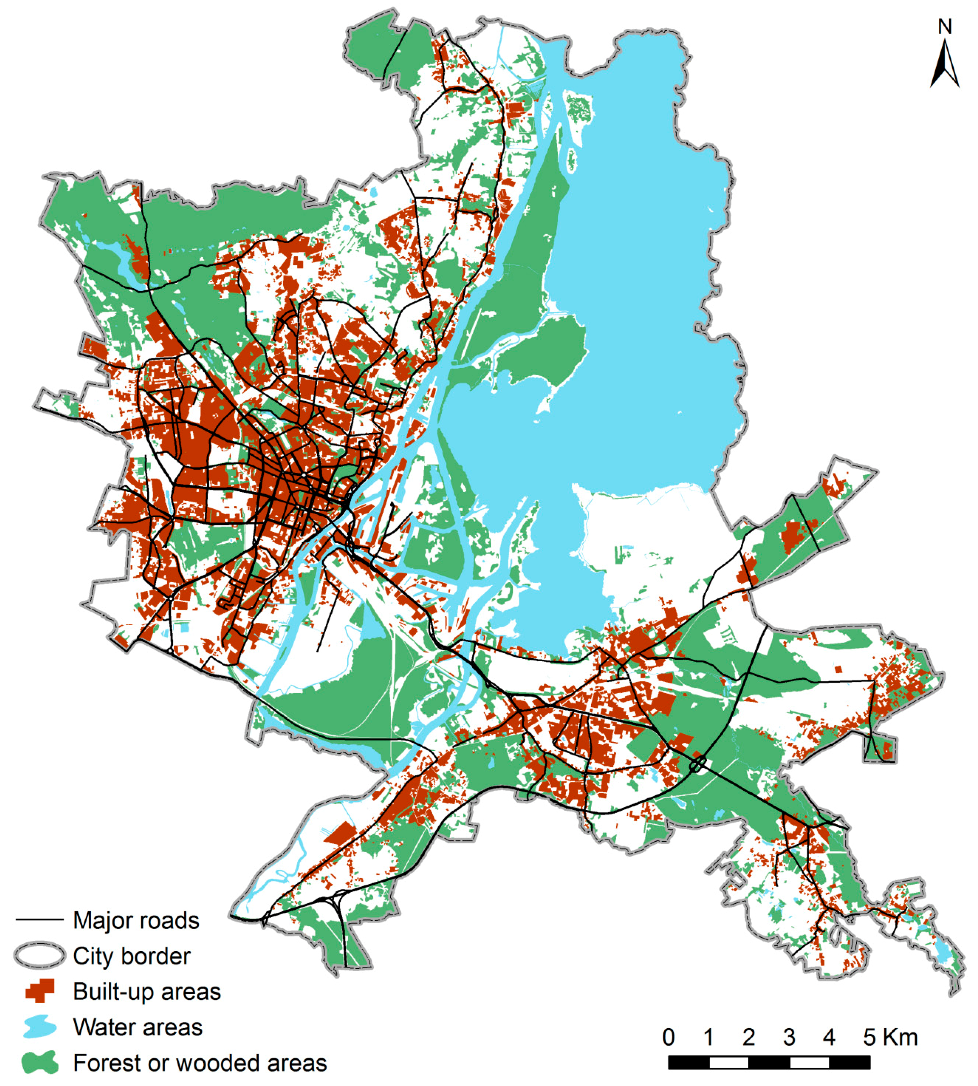
The case study area is the Commune of the City of Szczecin, situated in the northwest of Poland, next to the Polish–German border, on the Odra River. In 2015, Szczecin had ca. 405,000 inhabitants. The total area of the city is ca. 300 km
2, of which ca. 78 km
2 are forest or wooded areas, ca. 70 km
2 are water areas, and only ca. 45 km
2 are built-up and inhabited areas (
Figure 1).
Since 1989, Poland’s economic, political, and social systems have been changing rapidly. This caused the unprecedented economic growth and spread of wealth but led to some negative effects, as well, including the rapid declines of the industrial sector, state-owned farms, and, for sea-side regions, the maritime sector. This resulted in massive unemployment and emigration (see [
31]), which would theoretically create a favorable crime environment for Szczecin, which was affected by these developments, as well. In fact, the crime rate in Szczecin is rather moderate in comparison with other big cities in Poland, with 34 crime incidents per 1000 inhabitants in 2010. In this context Szczecin is a good research field to study urban crime, because of the crime rate level representative for other large cities in Poland, the differentiated structure of the built-up areas (the midtown was built at the end of 19th century and was not destroyed in WWII), sea and inland port areas, industrial and postindustrial areas, vast green areas of different type (e.g., forest, large cemetery, parks, allotment gardens), single-family houses of different types and built at different times, block of flats areas build mainly in the socialist period from 1945–1990, and new gated residential areas developed in the last 15 years, serving as residences for mostly upper-class inhabitants of Szczecin. Last, but not least, the relatively high quality of the collected crime data, and the willingness by the City Police Department to cooperate is also an important factor of choosing Szczecin as the study area for this research.
3.2. Crime Data
All criminal events collected in Poland by the police and classified as a potential crime are registered and stored in the so-called “Course of Service Electronic Register”. In the period from 2006 to 2010, 40,570 individual crimes were recorded and provided by the City Police Department of Szczecin to be analyzed in this study. Most of them are property crimes, but also robbery and similar crimes against health and life. All crimes were originally classified by the police into 17 categories according to the polish criminal code. To avoid low counts of crime events and get a more synthetic perspective the 17 original categories of crimes were reclassified and aggregated to nine crime types (see
Table 1). Main criteria for grouping included whether a person, a property, or a combination of both were the target of the crime and the similarity of crime types originally registered by the police.
Before proceeding with the analysis, crime data needed to be carefully cleaned in order to eliminate incorrect addresses, duplicate records, and spelling mistakes of street address names.
After the cleaning process, the geocoding of the crime data was carried out. All crime events registered by the police were geocoded to the corresponding address location. A total of 31,319 crimes, 77.2% of the 40,570 originally registered crimes, were successfully geocoded (
Table 2).
It is important to note that geocoding rates of all crime types dropped during the time period from 2006 to 2010 from 82.0% to 75.3% for unknown reasons. The geocoding percentage varies among crime types. It is highest for residential crimes (90.2%) and commercial crimes (85.1%), where the location of the criminal event is easy to determine. However, in some cases, both crime types have been registered to non-existing addresses. Relatively high average geocoding rates were found for car crimes (81.1%) and property damage (78.2%). The lowest average rates are represented by drug crimes (66.6%) and robbery (62.8%). Addresses for both crime types are not easy to determine, because the location of apprehension of a suspicious person is often not the same as the place of the crime event, and sometimes, the location of the crime cannot be identified by the police, at all. Often, police officers registered the street name, but not the number of the house. Many cases of robbery and drug crimes happen in open spaces, like parks, squares, or between buildings, especially in the block of flats of residential areas. In such situations the police is not able to determine the address of the crime event.
The geocoding rates for some crime types achieved in this study are below the 85% that Ratcliffe [
32] is stating as the acceptable level. In addition to the limitations already discussed above, further reasons why the data could not be geocoded at a higher rate include crime data being outside of Poland, outside of the city of Szczecin, in a train coming or leaving Szczecin, on a street coming or leaving Szczecin, missing or incorrect building number, and unknown street names, which made it difficult to indicate the exact location.
It was checked whether the incorrect addresses come from a few unique police beats, which would have resulted in biased spatial crime type distributions. We determined that the unsuccessful geocoded crime events are rather spatially randomly distributed. This fact, however, should draw some caution when interpreting the final results from this research in case of crime types with geocoding rates below 85%. Finally, it should be noted that in Poland, the availability of address-level crime data is, in general, very limited. Szczecin is one of the few big cities in Poland with such crime data sets.
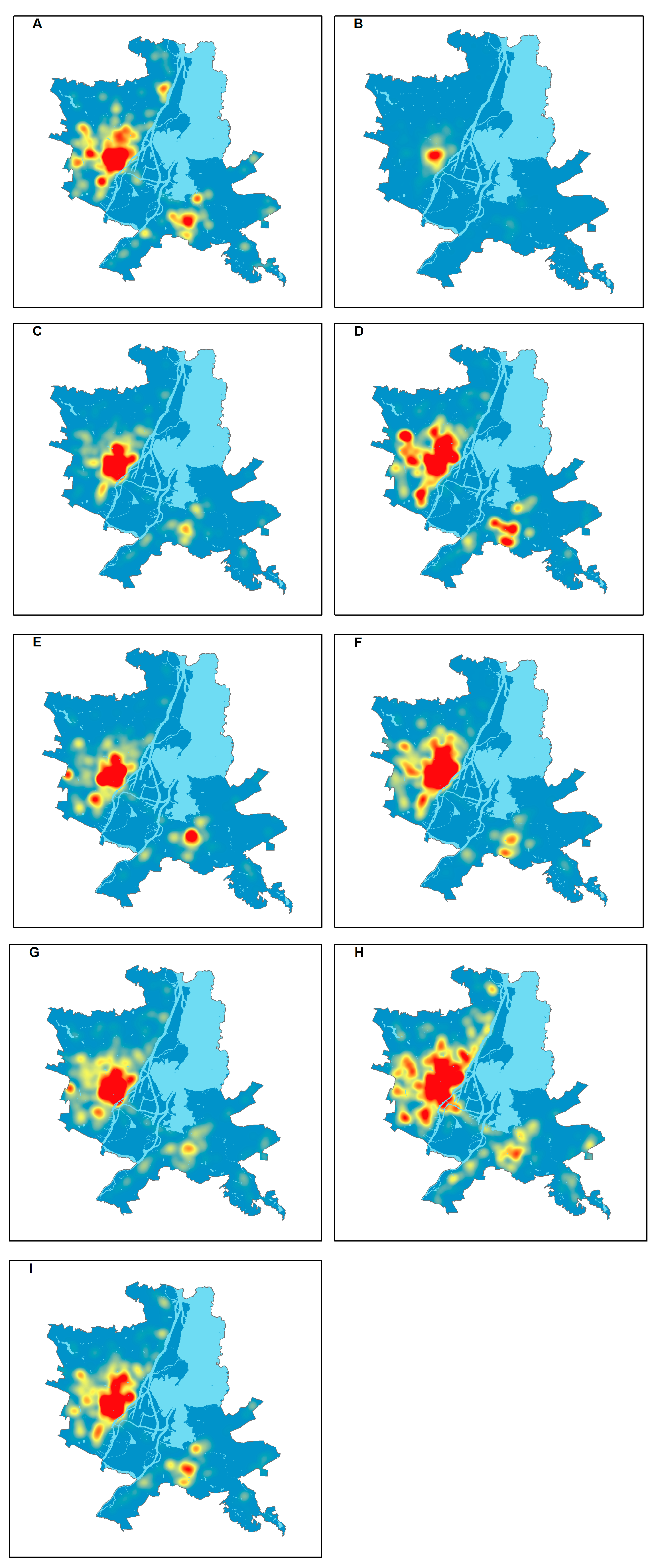
The spatial distribution of geocoded crime types is shown in
Figure 2. The most violent crime type,
fights and battery, with 550 incidents in total, is concentrated in the downtown area and in five large and three small areas around the commercial centers of urban districts.
Drug crimes, with a total count of 1447, are most numerous and, in fact, occur exclusively in the central part of downtown. The 962 total
robberies are concentrated in the downtown area and in residential areas adjacent to downtown in the north and in the northeast. Summing up, crimes against life and health are strongly concentrated in the downtown area, where many different land uses may attract crime, including municipal housing, commercial buildings, alcohol outlets, clubs and discos, and pawnshops.
Residential crimes, with 4632 incidents, are rather dispersed outside of the downtown area. As expected, they occur mainly in residential areas, predominantly in the land use type “municipal housing” that was built before World War II, and in five areas dominated by the land use type “block of flats”. The 2380 commercial crimes are concentrated in the downtown area and in residential areas adjacent to downtown in the north and around three big shopping malls (land use type “commercial buildings”). Car crimes, with 9481 incidents, similarly to commercial crimes, are concentrated in the downtown area and in residential areas to the north. Smaller hot spots of car crimes occur in the large residential areas of land use type “block of flats”. Similar to robberies, the crime type, theft of property—other with 6404 incidents, are concentrated in the downtown area and in residential areas to the north and northeast, where the land use type is predominantly “municipal housing”. Smaller hot spots occur around big shopping malls, indicated by the land use type “commercial buildings”. Burglaries in other commercial buildings account for 2277 incidents, and occur mainly in the downtown area and in the large residential area immediately to the north. Smaller hot spots occur around big shopping malls and mixed industrial and commercial areas defined by the land use type “commercial buildings”. In total, 3156 property damage crimes, similar to many other crime types, occur mainly in the downtown area and in the residential area to the north, which belongs mostly to the municipal housing land use type. A small hot spot is located in the large residential area in the east, on the right hand side of the Odra River, which is made up of the land use types “block of flats” and “commercial buildings”.
Summing up, crimes against property are strongly concentrated in the downtown area, where many different land use types potentially attract crime. These land uses include municipal housing, commercial buildings, alcohol outlets, clubs and discos, pawnshops, as well as residential areas to the north with mainly the land use type “municipal housing”, and around shopping malls that belong to the land use type “commercial buildings”.
3.3. Land Use Data
Most information on land use types (the land use type selected is defined as the kind of territorial land use (e.g., green area), building (e.g., municipal housing), or facility (e.g., alcohol outlet) potentially influencing the spatial distribution of crime), hypothetically influencing crime, came from the Topographic Geodatabase provided by the Regional Center for Documentation of Geodesy and Cartography in Szczecin. This geodatabase is prepared in a scale of 1:10,000, the used reference system is PL_PUWG_1992, and the registration number is 32-2-5-2-2-2270-19012012-4. Other address point data were obtained from the City Police Department of Szczecin (monitored police areas), from the Szczecin City Hall (alcohol outlets), and from the Municipal Housing Office of Szczecin (municipal housing). Some address point data were obtained by the authors from the Internet, including buildings of justice, clubs and discos, cultural facilities, dormitories, hotels, and pawnshops. All land use types, number of objects, and sources of data are listed in
Table 3.
Without doubt, other factors besides land use can influence the spatial distribution of crime such as neighborhood demographics, population distribution, unlit and/or secluded parts of a city, or opportunities for crime, for example, a full parking garage increases the likelihood for car thefts. However, some of these other factors are strongly correlated to particular land use types, for example, neighborhood demographics are influenced by the land use type “residential area”, since residents of municipal housing are mainly poor, older, lower educated, partly underemployed or unemployed, and, in many cases, socially deprived. In contrast, block of flats represents a residential area of the “middle class” representing citizens that are fully employed and often work in public sector. Finally, single-family housing areas, after a long process of economic stratification in Poland, are neighborhoods, where the rich, well educated, representatives of business, managers, freelancers, artists, lawyers, medicals, dentists, and professors live. Many rather large land use types are in fact not populated, including cemeteries, allotment gardens, industrial plants, railway stations and bus terminals, and green areas, which means that population-based crime rates may be misleading in such areas. Unlit and/or secluded parts of cities can be mainly found in single-family housing areas, as well as in cemeteries, and in vast green areas. Cars that can be stolen are highly concentrated in the downtown area from the morning to the afternoon, and in residential areas, including downtown, in the evening and at night. With this in mind, this research focuses on exploring the influence a large number of land use types has on crime and is the first study of this kind in the city of Szczecin.
3.4. Methods and Analysis
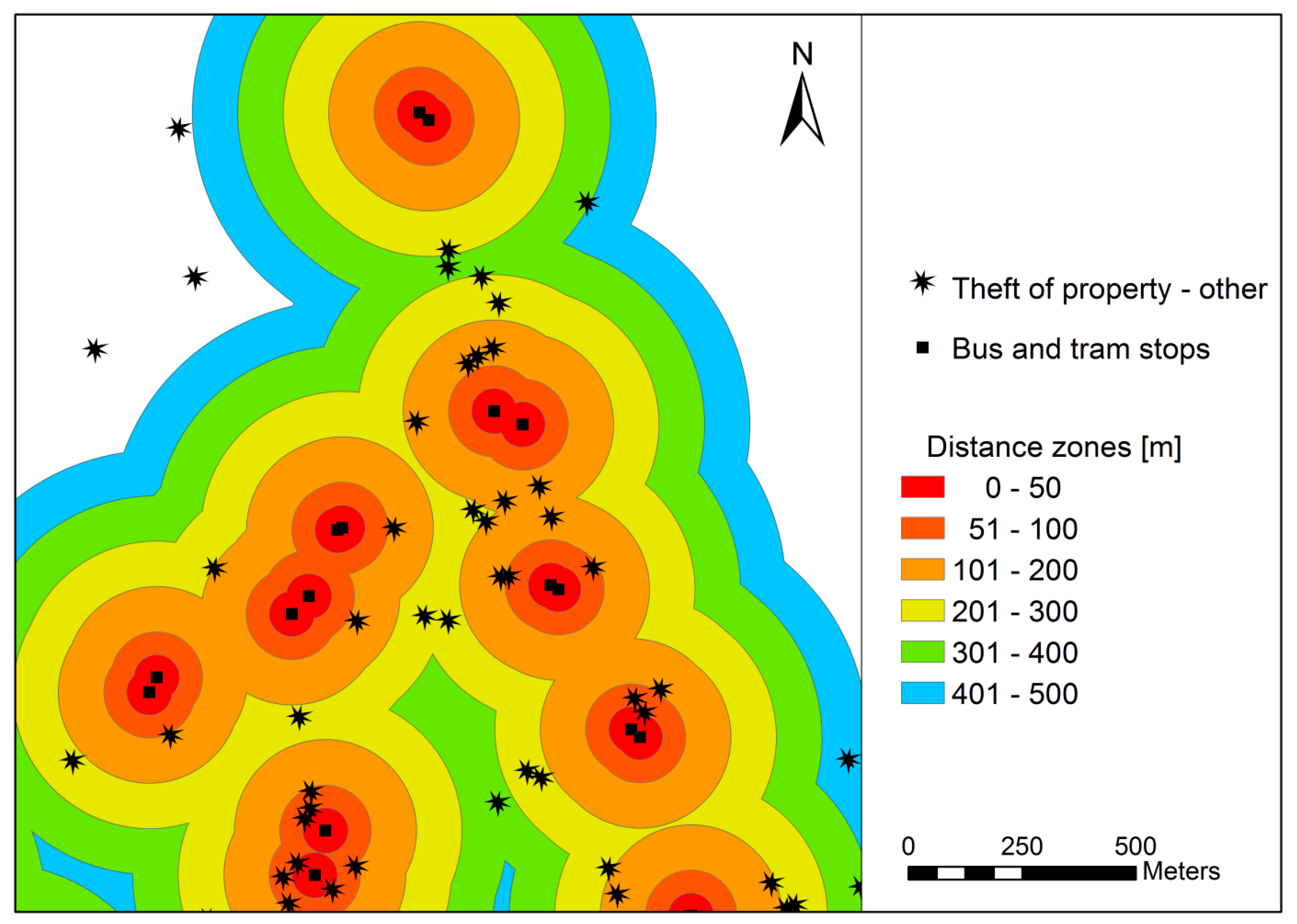
The first step in the empirical analysis was the geocoding of crime and land use data. This step, as all other analysis steps, was performed with ArcGIS™ 10.x. Crime incidents and some land use types are displayed as points (e.g., alcohol outlets). Other land use types are shown as polygons (e.g., green areas). Next, distance zones were created around each of the 30 land use types (compare
Table 3) at 50 m or 100 m distance intervals. Distance zones are zones created inside the land use potential influence range (0–500 m) using the ArcGIS 10.x tool Multiple Ring Buffers (0–50, 51–100, 101–200, 201–300, 301–400, and 401–500 m). The land use potential influence range defines the area created by setting a 500 m buffer around geocoded address points and polygons of particular land use type. Adopting a buffer of 500 m from points and polygons neutralizes the effects of small changes of the location of these land use types. If ring buffers were next to each other, they did not overlap, but were merged with each other. An example of merged ring buffers for a portion of the study area is shown in
Figure 3. Then, the density for the total number of crimes and for each individual crime type and each distance zone was computed. Finally, 1800 crime location quotients (LQC) for all crimes, for each individual crime type, for each distance zone, and for each of the 30 land use types were calculated. The LQC is the main tool used to evaluate the direction (attraction or detraction), range (distance zone), and the strength of the influence of specific land use types on specific crime types.
3.5. Crime Location Quotient (LQC) as a Measure of Influence of Land Use on Crime
3.5.1. The LQC Concept
The location quotient is a commonly used formula in mainly the social and economic research aiming to evaluate the level of spatial concentration [
33]. This method allows comparing density indexes of specific objects or phenomena across areas divided into territorial units of observation. It was introduced into criminological research by Brantingham and Brantingham [
34]. In a later study, the same authors [
35] state that “the LQC could be particularly important when studying crimes that are dependent on movement and activities, and allows researchers to incorporate socioeconomic data into crime figures”. Finally, Brantingham and Brantingham [
36] point out that “LQCs are also indicators of what attracts people, both locally and from a distance, to a particular location. Some crime sites are crime generators; others are crime attractors”. In the research that is presented in this paper, LQCs are used to indicate land use types being generators/attractors or detractors of crime.
The LQC continues to be successfully applied to research on the spatial distribution of crime. Carcach and Muscat [
37] use location quotients to analyze changes in crime structures over time and across geographical areas, and to examine the role that socio-economic characteristics play in shaping the crime profile of areas. Cahill [
38] (p. 146) argues that “…location quotients can be used to determine what areas have disproportionate levels of certain crimes…”. She suggests that “…further investigation might be done into the relationship between LQCs and population density, land use measures, the distance to downtown and residential stability”. The research in this present paper focuses on the relationship between LQCs and land use measures, indicated as attractors/generators or detractors of crime.
Andresen [
39] (p. 2442) in his extended methodical study on location quotients in crime analysis concluded that “… the use of this measure of crime is rather underutilized, it provides yet another understanding of why particular crimes occur in particular places by capturing those characteristics that attract criminal activity”, and that “… location quotients are able to identify specialization in crime even in the presence of a small crime count”. The research in this paper faces the same two problems of crime attractors and small crime counts. Zhang and Peterson [
40] in their study on neighborhood crime in Omaha use location quotients and crime density as alternative measures to broadly apply population-based crime rate indicators. They concluded (p. 17) that “…an enhanced understanding of the effectiveness and statistical properties of LQCs has been gleaned. We found that high crime neighborhoods tend to have a diversified profile and low crime neighborhoods are more likely to have a specialized profile of crime. While LQCs could help us identify the prevalent types of crime across urban neighborhoods, LQC values may be misleading (inflation or deflation) by especially for neighborhoods with extremely low or high occurrence rate of crime. Thus LQCs are of limited value”. Regarding the phenomenon of specialization vs. diversification, the results obtained by Zhang and Peterson [
40] are in line with the results of this present study. However, they study the influence of land uses on the distribution of crime at the local level, whereas in this research the spatial distribution of crime at the level of the whole city is analyzed. Finally, Andresen [
41] (p. 83) states that “the location quotient, though sometimes following a similar pattern as the crime rate, shows substantially different spatial patterns from crime type to crime type. These different patterns … are representative of the opportunity surface of crime. Different places are abundant in different types of opportunities, so it is no wonder that these places “specialize” in different crime types”.
In a recent study, Bella di et al. [
42] extensively discuss the use of five different indicators of crime, including counts, population-based rates, risk-based rates, crime density, and location quotients). They conclude (p. 672) “…that no existing indicator seems to have qualities required to stand alone without the risk of producing a macroscopic bias in the way public administration perceive the spatial distribution of crime through an urban environment”. Looking for a better solution they carried out an experimental analyzing only 30 burglaries and 35 shop thefts observed from 1 January 2009 to 27 July 2010 in a specific neighborhood in Genoa, Italy. They analyze this small sample size with complex statistical methods, including Principal Components Analysis, Multidimensional Scaling, and Partial Order Scalogram Analysis by Coordinates (POSAC). The results from the POSAC model seem to have the most advantages regarding the requirements of public administration. In another study, Bella di et al. [
43] develop a set of statistical measures called Median Line Angular Segment Analysis (MLASA) based on the configuration concept of space proposed by Hillier [
29]. This interesting approach provides a new perspective on incidents like predatory crime, arson, or criminal damage, occurring in the open space. The very specific street pattern of the downtown area of Szczecin consisting of many star-shaped places and streets that are often not parallel to each other, may be a good study area for verifying the results obtained by Bella di et al. [
42,
43].
McCord and Ratcliffe [
19] convincingly reveal many concerns of the LQ analysis. Instead of it they propose the Intensity Value Analysis (IVA) as more precise (IVA requires precisely geocoded points (x, y coordinates) of crime events and influencing facilities. For many crime and land use types such precision is unattainable). To avoid most of these weaknesses of the LQ analysis, in this study, the area to be compared with particular distance zones around various land use types (point or area) was restricted to the buffer of 500 m, and did not include the whole study area. Areas potentially free of crime and analyzed land use types were not considered. Additionally, we did not use one distance zone of potential influence, similar to all but six other studies. This allows setting the range of influence not a priori but a posteriori, after empirical analysis of crime density across the distance zones.
3.5.2. The LQC Formula
This research uses the name “Crime Location Quotient (LQC)” and the following formula was used:
where
| is the LQC for crime type m for distance zone i and land use type k; |
| is the number of events for crime type m within distance zone i from land use type k; |
| is the area of distance zone i from land use type k; |
| is the number of events for crime type m within the potential influence range of land use type k (distance zone 0–500 m); |
| is the area of the land use type k with the potential influence range of distance zones 0–500 m); |
| I | are six distance zones: i = 1–6 (0–50; 51–100; 101–200; 201–300; 301–400; 401–500 m); |
| K | defines the 30 land use types (k = 1–30); and |
| M | defines the number of crimes in total and the nine individual crime types (m = 1–10), |
In summary, ten LQC (total number of crimes plus nine crime types) were calculated for each land use type, and for each of the six distance zones, resulting in a total of 1800 (10 crime (types) × 30 land uses × 6 distance zones) that this entire analysis is based upon.
The LQC measure enables a comparison between the crime density for the land use potential influence range (defined as 0–500 m) with the crime density for specific distance zones. The LQC has been employed as a base for synthetic estimation of how a particular land use type influences the spatial distribution of a particular crime type. At specific distance zones from a land use type, the result of the LQC can be defined as follows: (a) if the LQC is 1, then the crime density in a particular zone is similar to the land use potential influence range; (b) if the LQC is larger than 1, then the crime density in a particular zone is higher than in the land use potential influence range; and (c) if the LQC is smaller than 1, then the crime density in the particular zone is lower than in the land use influence range.
Attracting (detracting) crimes by a particular land use type occurs, when the LQC in the immediate surrounding zone, i.e., 0–50 m, or at more distant zones is higher (lower) than 1.0. In other words, crime events concentrate (are lacking) in the area next to a specific land use form. The strength and direction of this influence has been established based on the value of the LQC.
CLQ classes have been arbitrarily and deliberately chosen. According to theoretical deliberations of the CLQ method, every positive/negative deviation from 1.0 indicates attraction or detraction. Descriptive statistics for particular land uses vary with respect to the mean, standard deviation, minimum and maximum, so the classes for the CLQ proposed by Andresen [
39] (pp. 2434–2440) based on standard deviation could not be used in our research. In our analysis we thus needed to assume arbitrary classes in order to compare the influence of different land use types (ranging from five railway stations and bus terminals to 2682 municipal housing projects, resulting in a large variation in the number and areas of land use types) on different crime types (ranging from 550 fights and battery incidents to 9481 car crimes) and make a comparison between them. We tried to use the Jenk’s optimization method but this method also leads to different class brakes for different land uses and crime types. It should be noted that the main research was to compare 1800 CLQs. In conclusion, the chosen solution may be the only possible solution regarding the purpose of this research. We decided to classify the values of the LQC into five classes according to its strength (
Table 4). In order to improve the readability of all result tables, each class has been assigned a specific color.
5. Discussion
The results discussed in this paper confirm the validity of the basic thesis of environmental criminology about the distribution and intensity of crime in an urban area. However, these results have a rather preliminary character, and should thus be treated as a pilot study. More detailed and locally relevant results of this research might be found in Sypion-Dutkowska [
44].
A key factor in the research of the influence of the environment on the level and nature of crime is the assumed distance of influence. In the literature, a distance of 50 m is not often applied; usually the following distances have been analyzed in the past: 122 m (400 feet) for drug markets around liquor store, homeless shelters, and check-cashing stores [
45]; 160 m (0.1 mile) for drug corners having a small influence on violent crime [
46]; 250 m buffers around bus interchange and mall entrance that concentrate 27% of all reported crimes [
14]; and 300 m buffers around public housing developments that cause a higher level of aggravated assault [
11]. Sometimes, the size of an urban block [
4], a space unit [
34], or an urban area is used [
7,
9]. However, with this approach, there is a risk of omitting crime hot spots located outside the assumed zone of influence of a given spatial land use type. The method applied in this research investigating the distribution of crime across six distance zones of up to 500 m allowed for avoiding that risk. However, this research has shown that the zone of strong influence of specific land use types on crime in total is 50 m and that the zone of attracting crime, on average, across all land use types reaches up to 200 m. Such a result is in line with results from Brantingham and Brantingham [
34]. A similar range of maximum influence was stated by Holzman et al. [
11]. A more detailed analysis of the influence of
alcohol outlets during 2006–2010 has also shown a very strong attraction of crime between 0–50 m around outlet locations and a zone of a decreasing crime attraction beyond 50 m up to 200 m.
The results of the empirical analyses in this research unambiguously confirm the crime attracting influence of
alcohol outlets. It is perhaps the most important result of this paper. In research on large US cities, the concentration of common crimes (mainly mugging and street theft) around pubs, restaurants, and other places of alcohol distribution has been confirmed [
5,
7]. In future research, it should be examined to what extent the local crime level and other land use types strengthen or weakens the crime-generating influence of alcohol outlets. Moreover, an analysis of the influence of specific types of
alcohol outlets, such as bars and restaurants, pubs, groceries, liquor stores, and supermarkets on crimes should be carried out.
In numerous studies in the US, it has been confirmed that public housing and its immediate neighborhoods are characterized by an increased crime [
4,
8,
11,
18,
21]. However, Greenberg et al. [
20] emphasize, based on the analysis of eight types of serious crimes committed in housing estates, that different forms of management influence the level of local crime stronger than social variables, such as the sense of bond with the territory of an estate or the level of social control. In this research,
municipal housing is characterized by a considerable strong attracting power of influence in the zone 0–50 m, especially for
drug crimes,
robbery,
residential crimes, and
property damage. The specificity of the 19th century residential development of the downtown area of Szczecin, where
municipal housing dominates, co-exerts influence along with other land use types including
alcohol outlets and
commercial buildings. Explaining the impact that specific land use types have on the high concentration of crime in the downtown of Szczecin requires additional research.
In other research, public transportation routes and nodes have been identified as attracting crime [
6,
9,
19]. In our empirical study in Szczecin the attraction of crime at
bus and tram stops and
depots and transport bases is moderate and exerts an influence of up to 200 m. Both land use types are mostly associated with
robbery,
drug crimes, and
theft of property—other.
Another land use type attracting crime that has been confirmed in the literature is commercial and service points [
15,
16,
17]. A similar situation applies to Szczecin, especially in the zone 0–50 m. Crime types that are especially strongly attracted by this land use type include
commercial crimes, which is obvious, and
theft of property—other.
In the US and Canada, an influence of schools and other places of gathering of the youth on the concentration of crime has been examined [
12,
17,
21]. The influence of the land use type
dormitories and
school buildings on the distribution of crimes in Szczecin shows an attracting nature. However,
sport facilities and
university buildings are of a detracting nature. Places of concentration of the youth in their free time, i.e.,
clubs,
discos, and
cultural facilities attract crimes the strongest. These places especially attract
commercial crimes and
theft of property—other. In this research, parks and green areas of Szczecin do not exhibit a clear trend whether they attract or detract crime. This is in line with results of previous research (e.g., [
9,
13,
22]).
Summing up, the above discussion of results of this study shows that most land use types exert an influence on the distribution of crimes in one big Polish city and that this is similar to the influence compared to big cities in the US or Canada. When taking into consideration essential differences of the level of economic development, living standards, social structure, and every-day culture between Szczecin and cities in the US or Canada, this result is, on the one hand, surprising, while, on the other hand, confirming the general validity of the crime pattern theory.
6. Conclusions and Future Work
In general, the most important conclusions from this research are first that a strong influence of every land use type, of either an attracting or a detracting nature, is limited to the distance zone 0–50 m. This influence, impacts a building, an object, or an area and their immediate neighborhood. Second, land use types strongly influencing all crimes in the distance zone 0–50 m are directly acting as generators and include alcohol outlets, clubs and discos, cultural facilities, and municipal housing. One other land use type, namely commercial buildings, is indirectly acting as an attractor. Third, land use types strongly detracting all crimes in the distance zone 0–50 m are only indirectly acting detractors and include grandstands, cemeteries, green areas, allotment gardens, and depots and transport base. Fourth, the strong influence of directly acting generators of crime, namely alcohol outlets is stable throughout the entire observation period, despite the fact that the number of these facilities grew substantially from 179 in 2006 to 461 in 2010.
We believe that the results of this research are representative for other large Polish cities with crime rates averaging 30 to 40 registered offences per 1000 inhabitants (2010), such as Gdansk, Lodz, and Lublin. The main commonalities among these cities are the existence of a historical downtown area that is largely owned by the municipality and which exhibits the main tourist attractions. This area is densely populated by a socially disadvantaged population and intensively visited by tourists (especially Cracow). A further common characteristic of these cities are the large residential areas in the form of blocks of flats, as well as, single-family houses found outside the downtown area. Of course, all cities possess new shopping malls, built in the last 20 years. The capital city Warsaw, as well as Cracow, and to some extend Poznan and Wroclaw developed new metropolitan functions, and changed the structure of their downtown areas towards Central Business Districts (CBDs) in the last 25 years [
47,
48,
49,
50,
51]. The post-industrial Silesian conurbation, including the main city Katowice, has a much higher level of crime (above 500 registered offences per 10,000 inhabitants in 2009) and a very different urban structure with a larger proportion of socially disadvantaged population, living in deprived residential and mixed areas what are “mixed” areas, as well as vast industrial and post-industrial areas.
Policy implications and limitations derived from the findings of this research are threefold. First, the downtown area of Szczecin is a spatial hot spot for many different types of crime which is caused by many land uses that serve as attractors or generators of crime, but also by social and economic factors. This area would require public security improvement programs, in addition to already existing urban regenerations programs. The main limitation to introduce such improvement programs is the territorial organization of the City Police Department of Szczecin, since the downtown area is divided into two police stations. Second, the rapidly growing number of alcohol outlets which have been identified as strong crime attractors, should be more comprehensively monitored through public security efforts. Third, an effective urban public security policy requires an improved system of crime registration, supported by mobile geocoding devices in the field and GIS-based analysis in the police headquarter and police stations around the city. The main barriers of such a system are limited financial resources and routine behavior of the police based on traditional solutions.
Future research should address the question of how social conditions together with land use types cumulatively influence the spatial distribution of different crime types in a large urban area. In addition, urban crime should be investigated at different geographic scales, namely at the global (i.e., entire city) and local (city’s neighborhoods). This requires that more advanced GIS tools and geostatistical methods have to be applied.
The population of Polish cities is diverse in terms of gender and age, education, income, and housing conditions, whereas other dimensions of diversity, including cultural, racial, ethnic, and religious that strongly condition crime in many big cities all over the world, are not important in Poland [
49,
52]. The population in Polish cities is segregated by education, income, and housing conditions, which is reflected in the emergence of relatively homogeneous social areas. Social areas, in turn, have different levels and intensity of crime that is committed inside their territories.
The main goal of future work should investigate whether spatial clusters (hot spots) of crime at different urban scales (global and local) are determined by social factors. A full understanding and explanation of the distribution of crime in big Polish cities requires the combined use of both land use and socioeconomic variables applying the abovementioned approaches to the same data for different cities. Neighborhoods with different social areas determine in different ways the range and strength of the influence of generators, attractors, and detractors of crime. In addition, land use types have a significant influence on social areas in which they occur. These relationships have not yet been fully understood in Poland, partly, due to the lack of relevant empirical data and appropriate research methods. Point data on crime, GIS tools and geo-statistics would allow the significant growth of knowledge in this field.


