Determination of Areas Susceptible to Landsliding Using Spatial Patterns of Rainfall from Tropical Rainfall Measuring Mission Data, Rio de Janeiro, Brazil

 ,
,  ,
, 
Abstract
1. Introduction
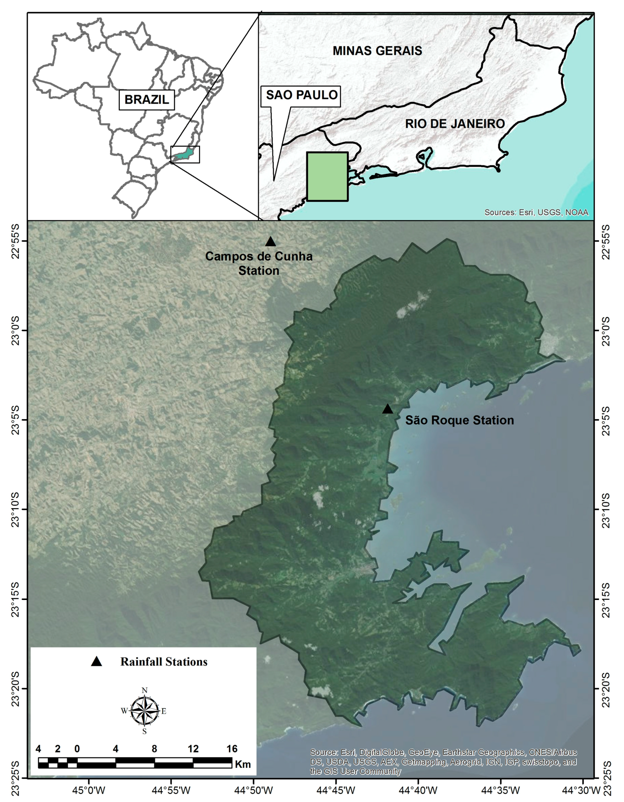
2. Study Area
3. Materials and Methods
3.1. Shallow Landslide Model
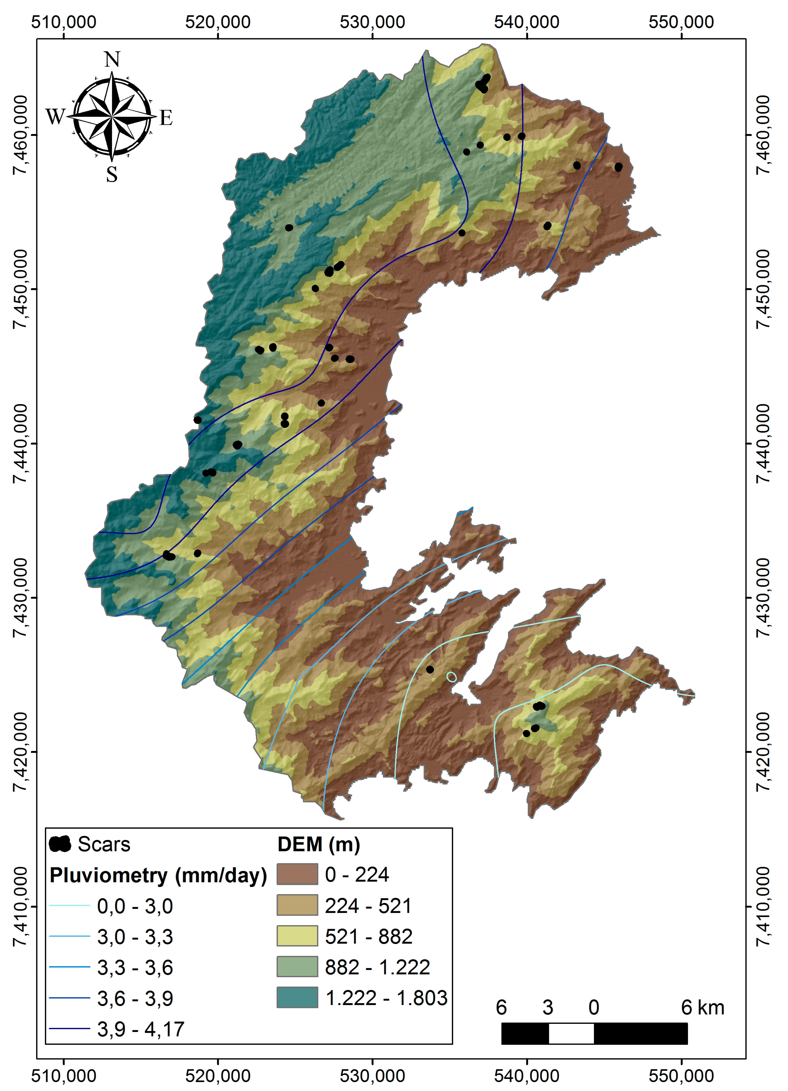
3.2. Digital Elevation Model and Terrain Attributes
3.3. Acquisition of Rainfall Data
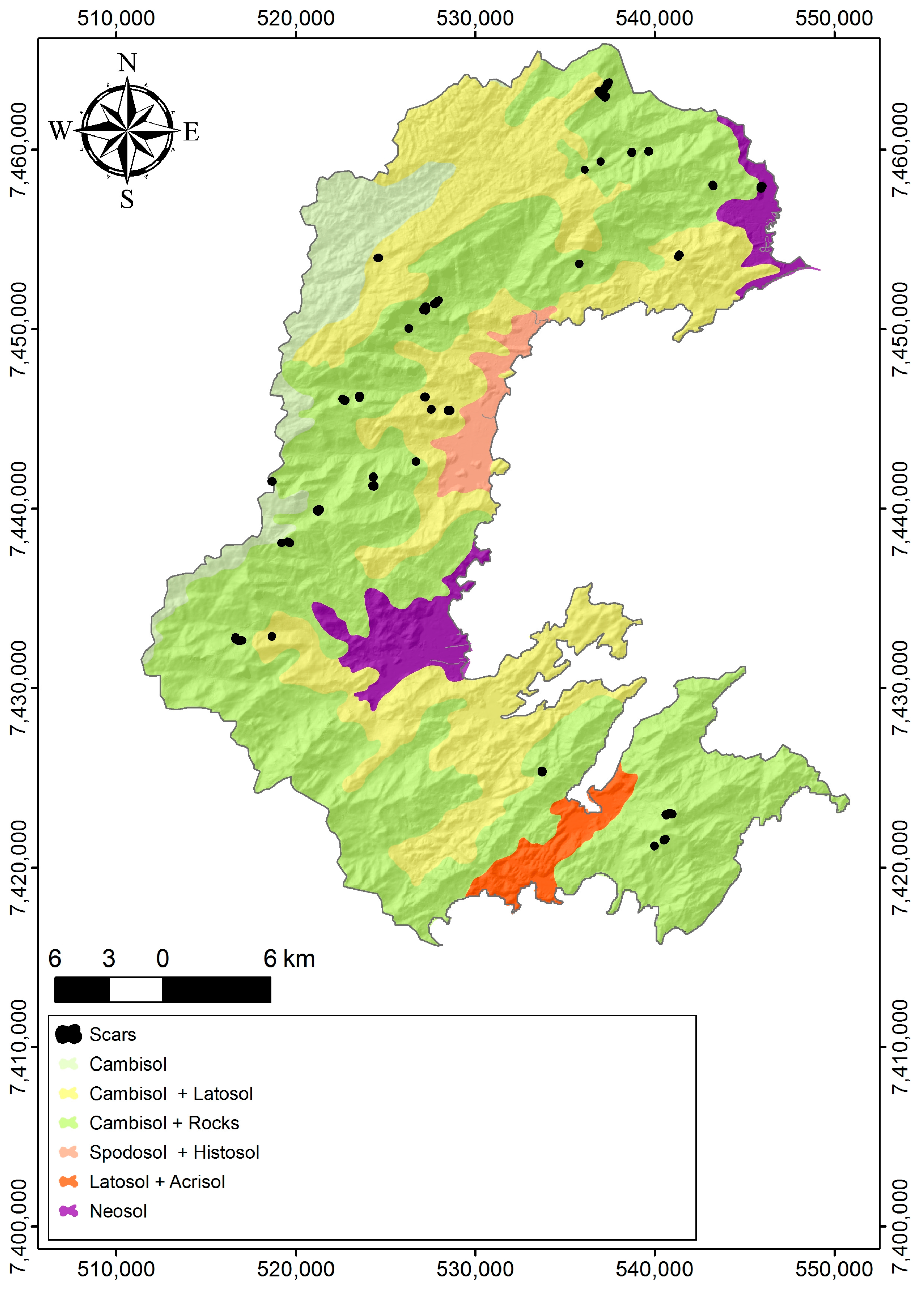
3.4. Parameterization of Soil Properties
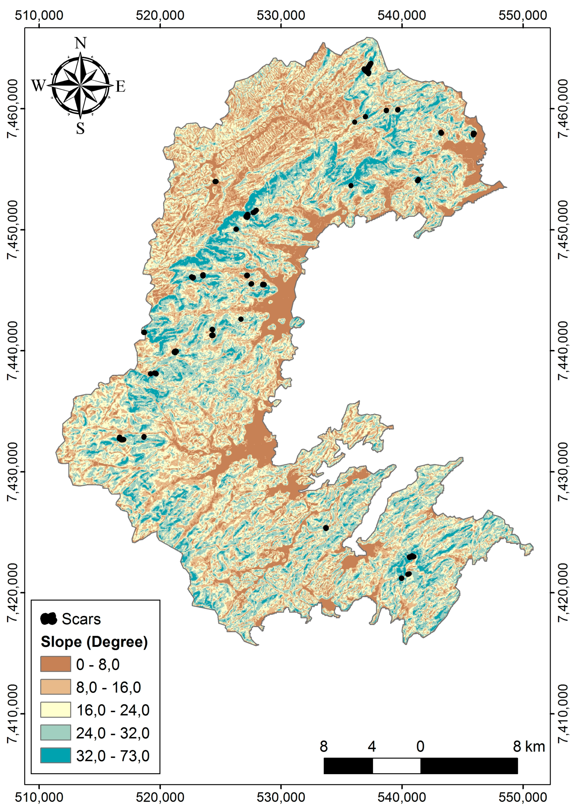
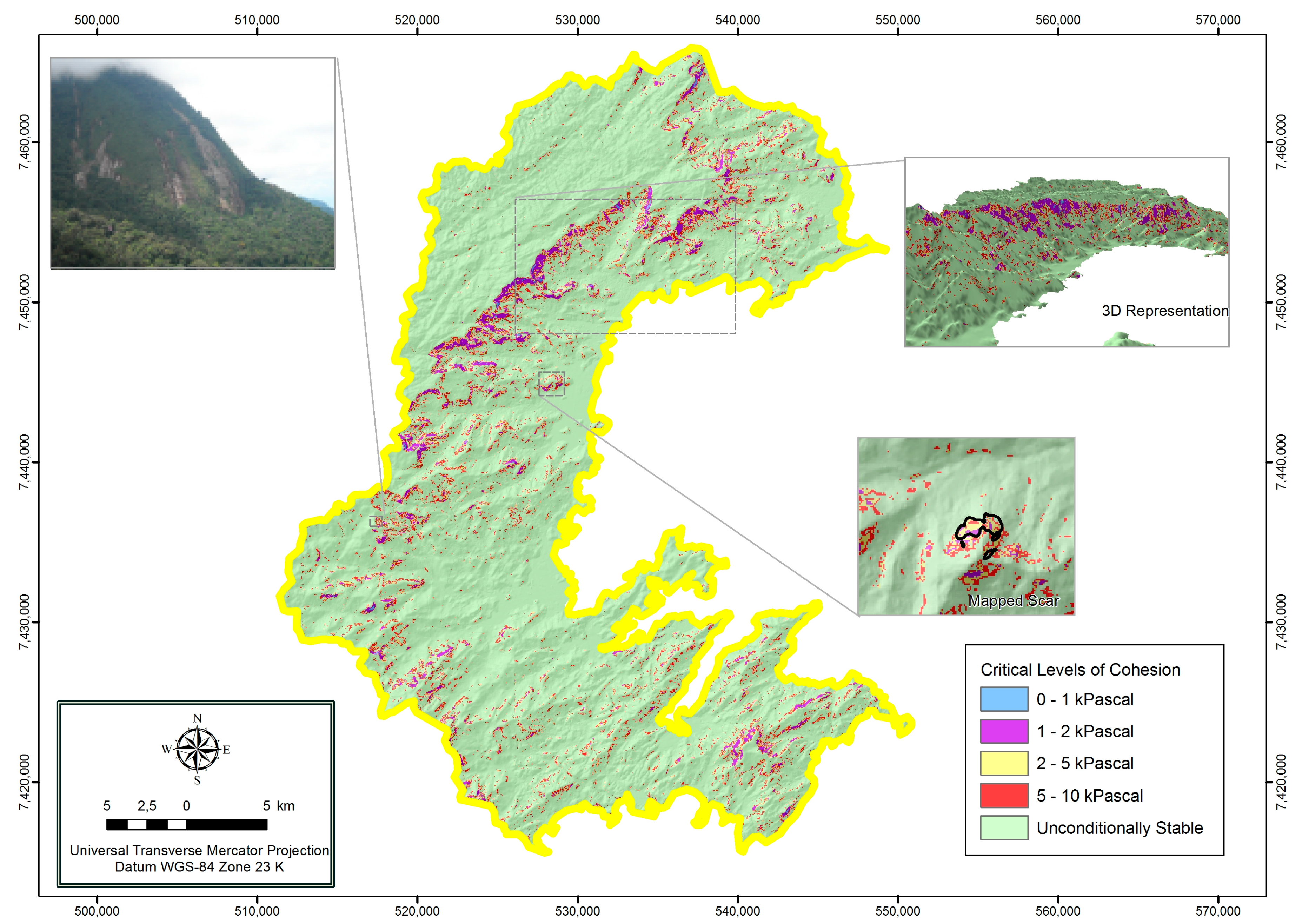
3.5. Landslide Mapping
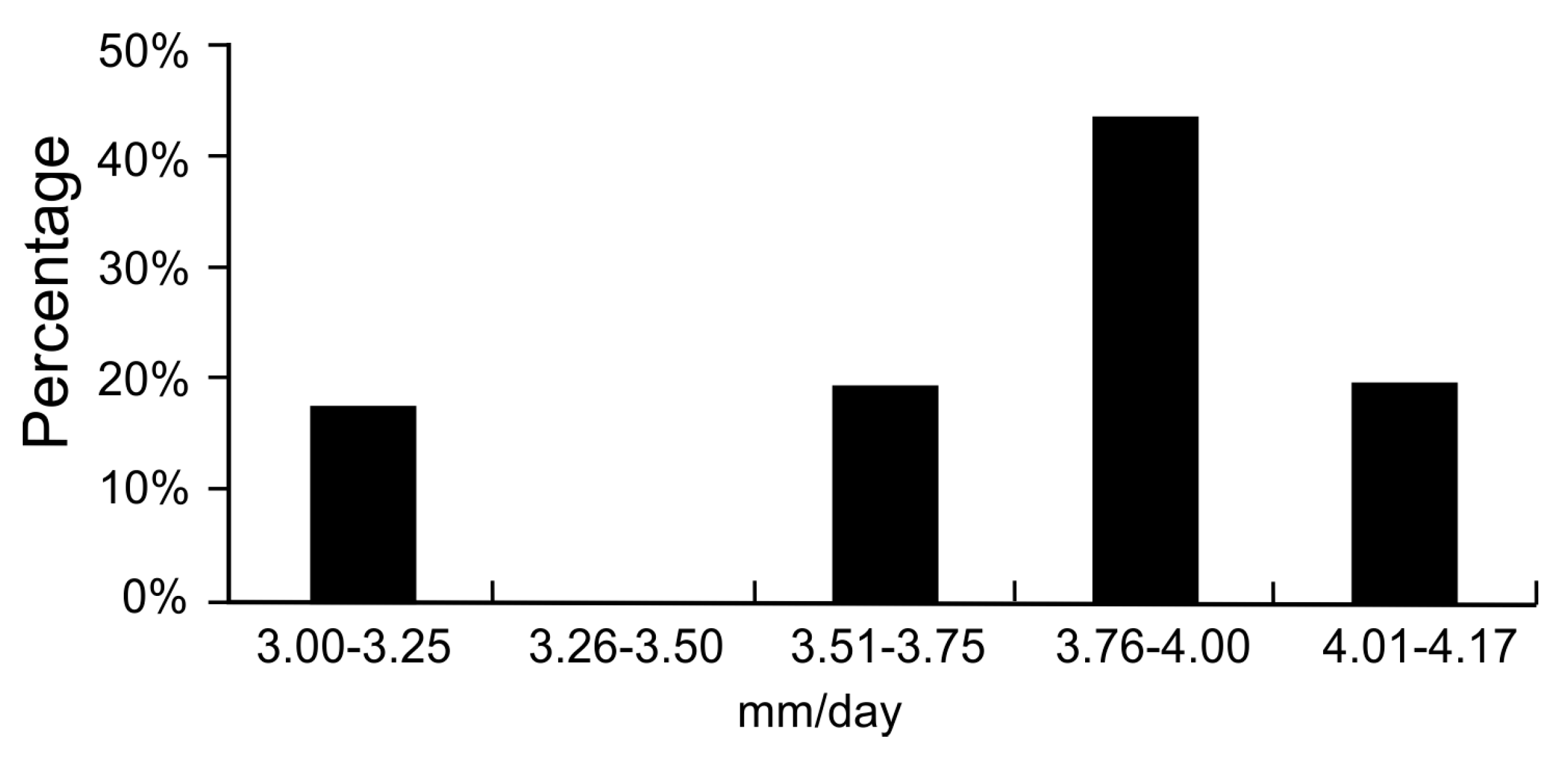
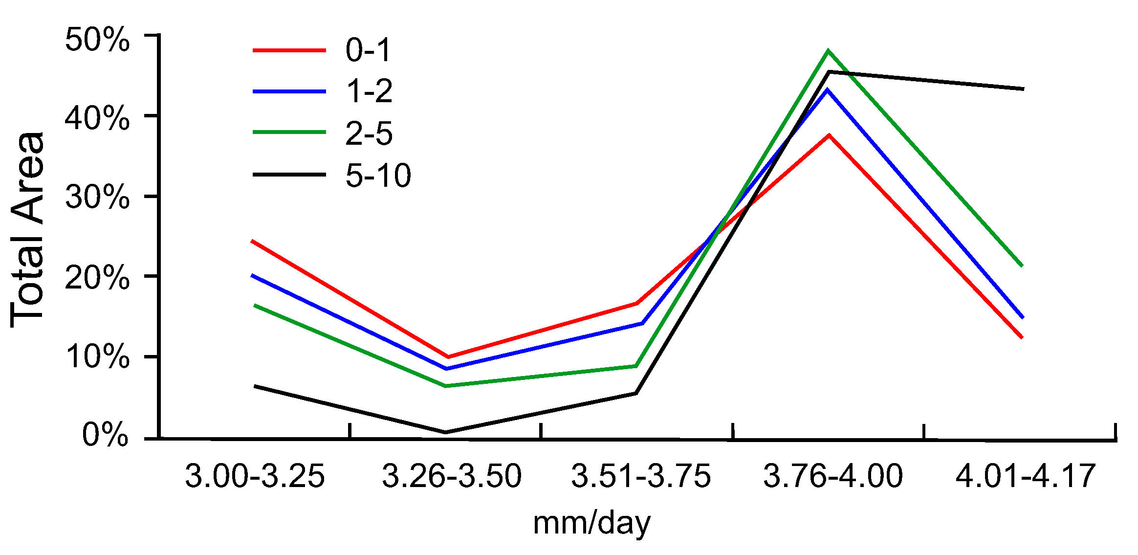
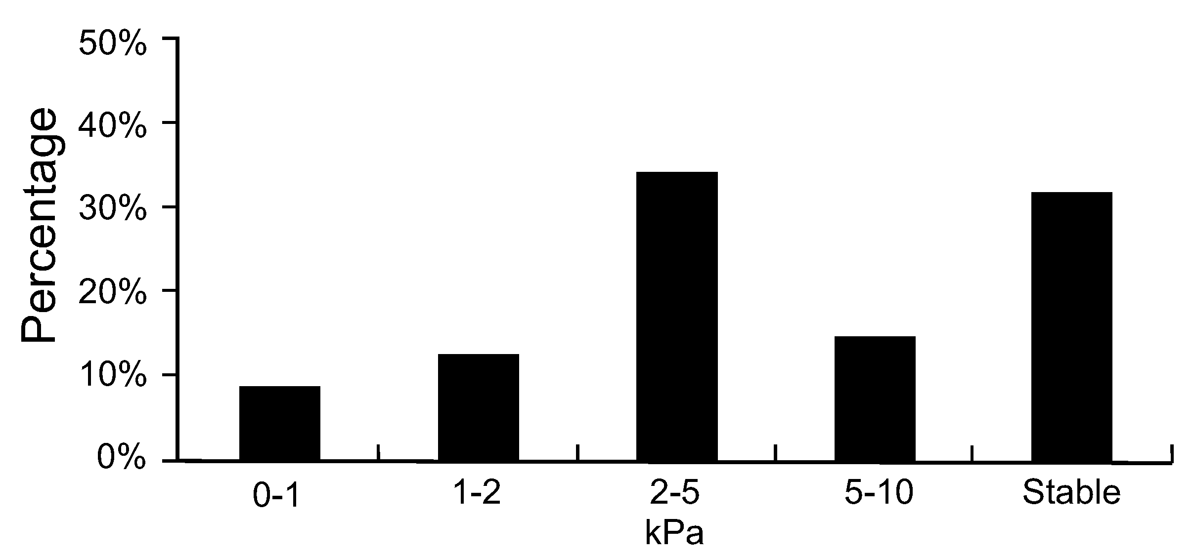
4. Results
5. Discussion
6. Conclusions
Acknowledgments
Author Contributions
Conflicts of Interest
References
- Innes, J.L. Lichenometric dating of debris-flow deposits in the Scottish Highlands. Earth Surf. Process. Landf. 1983, 8, 579–588. [Google Scholar] [CrossRef]
- Guimarães, R.F.; Gomes, R.A.T.; Carvalho Júnior, O.A.; Martins, E.S.; Fernandes, N.F. Análise temporal das áreas susceptíveis a escorregamentos rasos no Parque Nacional da Serra dos Órgãos (RJ) a partir de dados pluviométricos. Rev. Bras. Geociênc. 2009, 39, 190–198. [Google Scholar]
- Gomes, R.A.T.; Guimarães, R.F.; Carvalho Júnior, O.A.; Fernandes, N.F.; Amaral Júnior, E.V. Combining spatial models for shallow landslides and debris-flows prediction. Remote Sens. 2013, 5, 2219–2237. [Google Scholar] [CrossRef]
- Gomes, R.A.T.; Guimarães, R.F.; Carvalho Júnior, O.A.; Fernandes, N.F.; Amaral Júnior, E.V.; Martins, E.S. Identification of the affected areas by mass movement through a physically based model of landslide hazard combined with an empirical model of debris flow. Nat. Hazards 2008, 45, 197–209. [Google Scholar] [CrossRef]
- Borga, M.; Dalla Fontana, G.; Da Ros, D.; Marchi, L. Shallow landslide hazard assessment using a physically based model and digital elevation data. Environ. Geol. 1998, 35, 81–88. [Google Scholar] [CrossRef]
- Caine, N. The Rainfall Intensity: Duration Control of Shallow Landslides and Debris Flows. Geogr. Ann. Ser. A Phys. Geogr. 1980, 62, 23–27. [Google Scholar] [CrossRef]
- Guzzetti, F.; Peruccacci, S.; Rossi, M.; Stark, C.P. The rainfall intensity-duration control of shallow landslides and debris flows: An update. Landslides 2008, 5, 3–17. [Google Scholar] [CrossRef]
- Barredo, J.; Benavides, A.; Hervás, J.; van Westen, C.J. Comparing heuristic landslide hazard assessment techniques using GIS in the Tirajana basin, Gran Canaria Island, Spain. Int. J. Appl. Earth Obs. Geoinf. 2000, 2, 9–23. [Google Scholar] [CrossRef]
- Gupta, R.P.; Kanungo, D.P.; Arora, M.K.; Sarkar, S. Approaches for comparative evaluation of raster GIS-based landslide susceptibility zonation maps. Int. J. Appl. Earth Obs. Geoinf. 2008, 10, 330–341. [Google Scholar] [CrossRef]
- Malamud, B.D.; Turcotte, D.L.; Guzzetti, F.; Reichenbach, P. Landslide inventories and their statistical properties. Earth Surf. Process. Landf. 2004, 29, 687–711. [Google Scholar] [CrossRef]
- Mancini, F.; Ceppi, C.; Ritrovato, G. GIS and statistical analysis for landslide susceptibility mapping in the Daunia area, Italy. Nat. Hazards Earth Syst. Sci. 2010, 10, 1851–1864. [Google Scholar] [CrossRef]
- Rautela, P.; Lakhera, R.C. Landslide risk analysis between Giri and Tons Rivers in Himachal Himalaya (India). Int. J. Appl. Earth Obs. Geoinf. 2000, 2, 153–160. [Google Scholar] [CrossRef]
- Safaei, M.; Omar, H.; Ghiasi, V.; Yousof, Z.B.M. Applying geospatial technology to landslide susceptibility assessment. Electron. J. Geotech. Eng. 2010, 15, 677–696. [Google Scholar]
- Pardeshi, S.D.; Autade, S.E.; Pardeshi, S.D. Landslide hazard assessment: Recent trends and techniques. Springerplus 2013, 2, 1–11. [Google Scholar] [CrossRef] [PubMed]
- Baum, R.L.; Savage, W.Z.; Godt, J.W. TRIGRS—A Fortran Program for Transient Rainfall Infiltration and Grid-Based Regional Slope-Stability Analysis, Version 2.0; Open-File Report; U.S. Geological Survey: Reston, VA, USA, 2008; 75p.
- Montgomery, D.R.; Dietrich, W.E. A physically based model for the topographical control on shallow landsliding. Water Resour. Res. 1994, 30, 1153–1171. [Google Scholar] [CrossRef]
- Pack, R.T. The SINMAP Approach to Terrain Stability Mapping. In Proceedings of the 8th International Congress, International Association for Engineering Geology and the Environments, Vancouver, BC, Canada, 21–25 September 1998; p. 8. [Google Scholar]
- Montrasio, L.; Valentino, R. A model for triggering mechanisms of shallow landslides. Nat. Hazards Earth Syst. Sci. 2008, 8, 1149–1159. [Google Scholar] [CrossRef]
- Zizioli, D.; Meisina, C.; Valentino, R.; Montrasio, L. Comparison between different approaches to modeling shallow landslide susceptibility: A case history in Oltrepo Pavese, Northern Italy. Nat. Hazards Earth Syst. Sci. 2013, 13, 559–573. [Google Scholar] [CrossRef]
- Fernandes, N.F.; Guimarães, R.F.; Gomes, R.A.T.; Vieira, B.C.; Montgomery, D.R. Condicionantes Geomorfológicos dos Deslizamentos nas Encostas: Avaliação de Metodologias e Aplicação de Modelo de Previsão de Áreas Susceptíveis. Rev. Bras. Geomorfol. 2001, 2, 51–71. [Google Scholar] [CrossRef]
- Guimaraes, R.F.; Montgomery, D.R.; Greenberg, H.M.; Fernandes, N.F.; Gomes, R.A.T.; Carvalho Júnior, O.A. Parameterization of soil properties for a model of topographic controls on shallow landsliding: Application to Rio de Janeiro. Eng. Geol. 2003, 69, 98–108. [Google Scholar] [CrossRef]
- Gomes, R.A.T.; Guimarães, R.F.; Carvalho Júnior, O.A.; Fernandes, N.F. Análise de um Modelo de Previsão de Deslizamentos ( Shalstab ) em Diferentes Escalas Cartográficas. Solos Rochas 2005, 28, 85–97. [Google Scholar]
- Pike, R.J.; Sobieszczyk, S. Soil slip/debris flow localized by site attributes and wind-driven rain in the San Francisco Bay region storm of January 1982. Geomorphology 2008, 94, 290–313. [Google Scholar] [CrossRef]
- Chang, K.T.; Chiang, S.H.; Lei, F. Analysing the relationship between typhoon-triggered landslides and critical rainfall conditions. Earth Surf. Process. Landf. 2008, 33, 1261–1271. [Google Scholar] [CrossRef]
- Frattini, P.; Crosta, G.; Sosio, R. Approaches for defining thresholds and return periods for rainfall-triggered shallow landslides. Hydrol. Process. 2009, 23, 1444–1460. [Google Scholar] [CrossRef]
- Pagano, L.; Picarelli, L.; Rianna, G.; Urciuoli, G. A simple numerical procedure for timely prediction of precipitation-induced landslides in unsaturated pyroclastic soils. Landslides 2010, 7, 273–289. [Google Scholar] [CrossRef]
- Martha, T.R.; Kerle, N.; Jetten, V.; van Westen, C.J.; Kumar, K.V. Characterising spectral, spatial and morphometric properties of landslides for semi-automatic detection using object-oriented methods. Geomorphology 2010, 116, 24–36. [Google Scholar] [CrossRef]
- Dominguez-Cuesta, M.J.; Jimenez-Sanchez, M.; Colubi, A.; González-Rodríguez, G. Modelling shallow landslide susceptibility: A new approach in logistic regression by using favourability assessment. Int. J. Earth Sci. 2010, 99, 661–674. [Google Scholar] [CrossRef]
- Apip; Takara, K.; Yamashiki, Y.; Sassa, K.; Ibrahim, A.B.; Fukuoka, H. A distributed hydrological-geotechnical model using satellite-derived rainfall estimates for shallow landslide prediction system at a catchment scale. Landslides 2010, 7, 237–258. [Google Scholar] [CrossRef]
- Kirschbaum, D.; Stanley, T.; Zhou, Y. Spatial and temporal analysis of a global landslide catalog. Geomorphology 2015, 249, 4–15. [Google Scholar] [CrossRef]
- Hong, Y.; Adler, R.F. Predicting global landslide spatiotemporal distribution: Integrating landslide susceptibility zoning techniques and real-time satellite rainfall estimates. Int. J. Sediment Res. 2008, 23, 249–257. [Google Scholar] [CrossRef]
- Minder, J.R.; Roe, G.H.; Montgomery, D.R. Spatial patterns of rainfall and shallow landslide susceptibility. Water Resour. Res. 2009, 45, 1–11. [Google Scholar] [CrossRef]
- Smith, R.B.; Jiang, Q.; Fearon, M.G.; Tabary, P.; Dorninger, M.; Doyle, J.D.; Benoit, R. Orographic precipitation and air mass transformation: An Alpine example. Q. J. Meteorol. Soc. 2003, 129, 433–454. [Google Scholar] [CrossRef]
- Roe, G.H. Orographic Precipitation. Annu. Rev. Earth Planet. Sci. 2005, 33, 645–671. [Google Scholar] [CrossRef]
- Soares, F.S.; Francisco, C.N.; Carneiro, M.; Senna, A. Distribuição espaço-temporal da precipitação da região hidrográfica da Baía da Ilha Grande—RJ. Rev. Bras. Meteorol. 2014, 29, 125–138. [Google Scholar] [CrossRef]
- Hiruma, S.T.; Riccomini, C.; Modenesi-Gauttieri, M.C.; Hackspacher, P.C.; Neto, J.C.H.; Franco-Magalhães, A.O.B. Denudation history of the Bocaina Plateau, Serra do Mar, southeastern Brazil: Relationships to Gondwana breakup and passive margin development. Gondwana Res. 2010, 18, 674–687. [Google Scholar] [CrossRef]
- Eirado, L.G.; Heilbron, M.; Almeida, J.C.H. Os Terrenos Tectônicos Da Faixa Ribeira Na Serra Da Bocaina E Na Baía Da Ilha Grande, Sudeste Do Brasil. Rev. Bras. Geociênc. 2006, 36, 426–436. [Google Scholar]
- Schmitt, R.S.; Frimmel, H.E.; Fairchild, T.R. Neoproterozoic-Early Paleozoic events in Southwest Gondwana: Introduction. Gondwana Res. 2008, 13, 435–436. [Google Scholar] [CrossRef]
- Bueno, J.F.; Oliveira, E.P.; McNaughton, N.J.; Laux, J.H. U-Pb dating of granites in the Neoproterozoic Sergipano Belt, NE-Brazil: Implications for the timing and duration of continental collision and extrusion tectonics in the Borborema Province. Gondwana Res. 2009, 15, 86–97. [Google Scholar] [CrossRef]
- Cordani, U.G.; Teixeira, W.; D’Agrella-Filho, M.S.; Trindade, R.I. The position of the Amazonian Craton in supercontinents. Gondwana Res. 2009, 15, 396–407. [Google Scholar] [CrossRef]
- Flávio, F.; De Almeida, M.; Dal, C.; Carneiro, R. Origem E Evolução Da Serra Do Mar. Rev. Bras. Geociênc. 1998, 28, 135–150. [Google Scholar]
- Marques, L.S.; Ernesto, M. O magmatismo toleítico da Bacia do Paraná. In Geologia do Continente Sul-Americano: Evolução da Obra de Fernando Flávio Marques de Almeida; Mantesso-Neto, V., Bartorelli, A., Carneiro, C.D.R., Neves, B.B.B., Eds.; Beca: São Paulo, Brazil, 2004; pp. 245–263. [Google Scholar]
- Riccomini, C.; Velázquez, V.; Gomes, C.B. Tectonic controls of the Mesozoic and Cenozoic alkaline magmatism in central-southeastern Brazilian platform. In Mesozoic to Cenozoic Alkaline Magmatism in the Brazilian Platform; Gomes, C.B., Comin-Chiaramonti, P., Eds.; EDUSP-FAPESP: São Paulo, Brazil, 2005; pp. 31–55. [Google Scholar]
- Riccomini, C.; Sant’Anna, L.G.; Ferrari, A.L. Evolução geológica do rift continental do Sudeste do Brasil. In Geologia do Continente Sul-Americano: Evolução da Obra de Fernando Flávio Marques de Almeida; Mantesso Neto, V., Bartorelli, A., Carneiro, C.D.R., Neves, B.B.B., Eds.; Beca: São Paulo, Brazil, 2004; pp. 383–405. [Google Scholar]
- Almeida, F.F.M. The system of continental rifts bordering the Santos basin, Brazil. An. Acad. Bras. Cienc. 1976, 48, 15–26. [Google Scholar]
- Summerfield, M.A. Global Geomorphology; Longman Group, Ed.; Burnt Mill: Harlow, UK, 1991. [Google Scholar]
- Selby, M.J. Hillslope Materials and Processes; Oxford University Press: Oxford, UK, 1982. [Google Scholar]
- O’Loughlin, E.M. Prediction of Surface Saturation Zones in Natural Catchments by Topographic Analysis. Water Resour. Res. 1986, 22, 794–804. [Google Scholar] [CrossRef]
- Montgomery, D.R.; Schmidt, K.M.; Greenberg, H.M.; Dietrich, W.E. Forest clearing and regional landsliding. Geology 2000, 28, 311–314. [Google Scholar] [CrossRef]
- Dietrich, W.E.; Reiss, R.; Hsu, M.L.; Montgomery, D.R. A process-based model for colluvial soil depth and shallow landsliding using digital elevation data. Hydrol. Process. 1995, 9, 383–400. [Google Scholar] [CrossRef]
- Nefeslioglu, H.A.; San, B.T.; Gokceoglu, C.; Duman, T.Y. An assessment on the use of terra ASTER L3A data in landslide susceptibility mapping. Int. J. Appl. Earth Obs. Geoinf. 2012, 14, 40–60. [Google Scholar] [CrossRef]
- San, B.T. An evaluation of SVM using polygon-based random sampling inlandslide susceptibility mapping: The Candir catchment area(western Antalya, Turkey). Int. J. Appl. Earth Obs. Geoinf. 2014, 26, 399–412. [Google Scholar] [CrossRef]
- Santini, M.; Grimaldi, S.; Nardi, F.; Petroselli, A.; Rulli, M.C. Pre-processing algorithms and landslide modelling on remotely sensed DEMs. Geomorphology 2009, 113, 110–125. [Google Scholar] [CrossRef]
- Rozante, J.R.; Moreira, D.S.; de Goncalves, L.G.G.; Vila, D.A. Combining TRMM and Surface Observations of Precipitation: Technique and Validation over South America. Weather Forecast. 2010, 25, 885–894. [Google Scholar] [CrossRef]
- Wieczorek, G. Effect of rainfall intensity and duration on debris flows in central Santa Cruz Mountains, California. In Debris Flows/Avalanches: Process, Recognition, and Mitigation; Costa, J.E., Wieczorek, G.F.E., Eds.; Geological Society of America: Boulder, CO, USA, 1987; Volume 7, pp. 93–104. [Google Scholar]
- Vrieling, A.; de Jong, S.M.; Sterk, G.; Rodrigues, S.C. Timing of erosion and satellite data: A multi-resolution approach to soil erosion risk mapping. Int. J. Appl. Earth Obs. Geoinf. 2008, 10, 267–281. [Google Scholar] [CrossRef]
- Liu, J.K.; Shih, P.T.Y. Topographic correction of Wind-Driven rainfall for landslide analysis in central Taiwan with validation from Aerial and satellite optical images. Remote Sens. 2013, 5, 2571–2589. [Google Scholar] [CrossRef]
- Rogers, J.D.; Ahmed, M.F.; Ismail, E.H. Landslide Susceptibility Screening Using Wind-Driven Rainfall. Assoc. Environ. Eng. Geosci. 2016, 22, 297–318. [Google Scholar] [CrossRef]
- Ismail, E.H.; Rogers, J.D.; Ahmed, M.F.; Usery, E.L.; Abdelsalam, M.G. Landslide susceptibility mapping of Blue Nile and Tekeze River Basins using oblique rainfall-aspect rasters. Bull. Eng. Geol. Environ. 2017, 1–19. [Google Scholar] [CrossRef]
- Huffman, G.J.; Bolvin, D.T.; Nelkin, E.J.; Wolff, D.B.; Adler, R.F.; Gu, G.; Hong, Y.; Bowman, K.P.; Stocker, E.F. The TRMM Multisatellite Precipitation Analysis (TMPA): Quasi-Global, Multiyear, Combined-Sensor Precipitation Estimates at Fine Scales. J. Hydrometeorol. 2007, 8, 38–55. [Google Scholar] [CrossRef]
- Dinku, T.; Ceccato, P.; Grover-Kopec, E.; Lemma, M.; Connor, S.J.; Ropelewski, C.F. Validation of satellite rainfall products over East Africa’s complex topography. Int. J. Remote Sens. 2007, 28, 1503–1526. [Google Scholar] [CrossRef]
- Haile, A.T.; Rientjes, T.; Gieske, A.; Gebremichael, M. Multispectral remote sensing for rainfall detection and estimation at the source of the Blue Nile River. Int. J. Appl. Earth Obs. Geoinf. 2010, 12, 76–82. [Google Scholar] [CrossRef]
- Duncan, J.M.A.; Biggs, E.M. Assessing the accuracy and applied use of satellite-derived precipitation estimates over Nepal. Appl. Geogr. 2012, 34, 626–638. [Google Scholar] [CrossRef]
- Yong, B.; Chen, B.; Gourley, J.J.; Ren, L.; Hong, Y.; Chen, X.; Wang, W.; Chen, S.; Gong, L. Intercomparison of the Version-6 and Version-7 TMPA precipitation products over high and low latitudes basins with independent gauge networks: Is the newer version better in both real-time and post-real-time analysis for water resources and hydrologic ext. J. Hydrol. 2014, 508, 77–87. [Google Scholar] [CrossRef]
- Qiu, J.; Gao, Q.; Wang, S.; Su, Z. Comparison of temporal trends from multiple soil moisture data sets and precipitation: The implication of irrigation on regional soil moisture trend. Int. J. Appl. Earth Obs. Geoinf. 2016, 48, 17–27. [Google Scholar] [CrossRef]
- Chiu, L.S.; Liu, Z.; Vongsaard, J.; Morain, S.; Budge, A.; Neville, P.; Bales, C. Comparison of TRMM and water district rain rates over New Mexico. Adv. Atmos. Sci. 2006, 23, 1–13. [Google Scholar] [CrossRef]
- Bringi, V.N.; Chandrasekar, V.; Hubbert, J.; Gorgucci, E.; Randeu, W.L.; Schönhuber, M. Raindrop Size Distribution in Different Climatic Regimes from Disdrometer and Dual-Polarized Radar Analysis. J. Atmos. Sci. 2003, 60, 354–365. [Google Scholar] [CrossRef]
- Liu, L.L.; Cheng, Y.M.; Wang, X.M.; Zhang, S.H.; Wu, Z.H. System reliability analysis and risk assessment of a layered slope in spatially variable soils considering stratigraphic boundary uncertainty. Comput. Geotech. 2017, 89, 213–225. [Google Scholar] [CrossRef]
- Jiang, S.H.; Huang, J.; Yao, C.; Yang, J. Quantitative risk assessment of slope failure in 2-D spatially variable soils by limit equilibrium method. Appl. Math. Model. 2017, 47, 710–725. [Google Scholar] [CrossRef]
- Li, D.Q.; Jiang, S.H.; Cao, Z.J.; Zhou, W.; Zhou, C.B.; Zhang, L.M. A multiple response-surface method for slope reliability analysis considering spatial variability of soil properties. Eng. Geol. 2015, 187, 60–72. [Google Scholar] [CrossRef]
- Zhao, H.F.; Zhang, L.; Xu, Y.; Chang, D.S. Variability of geotechnical properties of a fresh landslide soil deposit. Eng. Geol. 2013, 166, 1–10. [Google Scholar] [CrossRef]
- Lora, M.; Camporese, M.; Troch, P.A.; Salandin, P. Rainfall-triggered shallow landslides: Infiltration dynamics in a physical hillslope model. Hydrol. Process. 2016, 3251, 3239–3251. [Google Scholar] [CrossRef]
- Michel, G.P.; Kobiyama, M.; Goerl, R.F. Comparative analysis of SHALSTAB and SINMAP for landslide susceptibility mapping in the Cunha River basin, southern Brazil. J. Soils Sediments 2014, 14, 1266–1277. [Google Scholar] [CrossRef]
- D’Amato Avanzi, G.; Falaschi, F.; Giannecchini, R.; Puccinelli, A. Soil slip susceptibility assessment using mechanical-hydrological approach and GIS techniques: An application in the Apuan Alps (Italy). Nat. Hazards 2009, 50, 591–603. [Google Scholar] [CrossRef]
- Aristizábal, E.; García, E.; Martínez, C. Susceptibility assessment of shallow landslides triggered by rainfall in tropical basins and mountainous terrains. Nat. Hazards 2015, 78, 621–634. [Google Scholar] [CrossRef]
- De Campos, T.M.P.; Andrade, M.H.N.; Vargas, E.A., Jr. Unsaturated Colluvium Over Roch Slide in a Forest Site in Rio de Janeiro. In Proceedings of the Sixth International Symposium on Landslides, Christchurch, New Zealand, 10–14 February 1992; Balkema A.A.: Rotterdam, The Netherlands, 1992–1995; pp. 1357–1364. [Google Scholar]
- De Campos, T.M.P.; Vargas, E.A., Jr.; Amaral, C.P.; Dell Avanzi, E. Instabilization factors of the residual soil slope in Nova Friburgo, Rio de Janeiro. In Proceedings of the II Conferência Brasileira sobre Estabilidade de Encostas, Rio de Janeiro, Brazil, 10–14 November 1997; pp. 967–975. [Google Scholar]
- Costa Nunes, A.J. Landslides in Soils of Decomposed Rock due to Intense Rainstorms. In Proceedings of the 7th International Conference on Soil Mechanics and Foundation Engineering, Mexico City, Mexico, 25–29 August 1969; Sociedad Mexicana de Mecanica de Suelos: Mexico City, Mexico, 1969; pp. 547–554. [Google Scholar]
- De Ploey, J.; Cruz, O. Landslides in the Serra do Mar, Brazil. Catena 1979, 6, 111–122. [Google Scholar] [CrossRef]
- Montgomery, D.R.; Sullivan, K.; Greenberg, H.M. Regional test of a model for shallow landsliding. Hydrol. Process. 1998, 12, 943–955. [Google Scholar] [CrossRef]
- Gaprindashvili, G.; Westen, C.J. Van Generation of a national landslide hazard and riskmap for Georgia. Nat. Hazards 2015, 80, 1–35. [Google Scholar]
- Maggioni, V.; Meyers, P.C.; Robinson, M.D.; Maggioni, V.; Meyers, P.C.; Robinson, M.D. A Review of Merged High-Resolution Satellite Precipitation Product Accuracy during the Tropical Rainfall Measuring Mission (TRMM) Era. J. Hydrometeorol. 2016, 17, 1101–1117. [Google Scholar] [CrossRef]


| Year | Campos de Cunha Station | São Roque Station |
|---|---|---|
| 2000 | 1392 | 1822 |
| 2001 | 1197 | 1853 |
| 2002 | 1286 | 2339 |
| 2003 | 1195 | 2441 |
| 2004 | 1457 | 2484 |
| 2005 | 1067 | 2756 |
| 2006 | 1159 | 2489 |
| 2007 | 1227 | 1918 |
| 2008 | 1509 | 2818 |
| 2009 | 1669 | 2934 |
| 2010 | 1639 | 2366 |
| Parameter | Value/Unit |
|---|---|
| Transmissivity (T) | 65 m2/day |
| Soil depth (z) | 1 m |
| Angle of internal friction (φ) | 33° |
| Bulk density (ρs) | 2 (g/cm3) |
| Critical Levels of Cohesion Class | Area (ha) | Percentage (%) |
|---|---|---|
| 5–10 kPa | 74 | <1 |
| 2–5 kPa | 2153 | 2 |
| 1–2 kPa | 2193 | 2 |
| 0–1 kPa | 3758 | 4 |
| Unconditionally Stable | 83,184 | 91 |
| Critical Cohesion (kPa) | 3.00–3.25 (mm/day) | 3.26–3.50 (mm/day) | 3.51–3.75 (mm/day) | 3.76–4.00 (mm/day) | 4.01–4.17 (mm/day) |
|---|---|---|---|---|---|
| 0–1 | 0 | 0 | 0 | 4 | 0 |
| 1–2 | 3 | 0 | 1 | 3 | 1 |
| 2–5 | 2 | 0 | 5 | 5 | 3 |
| 5–10 | 0 | 0 | 1 | 1 | 4 |
| Stable | 3 | 0 | 2 | 7 | 1 |
© 2017 by the authors. Licensee MDPI, Basel, Switzerland. This article is an open access article distributed under the terms and conditions of the Creative Commons Attribution (CC BY) license (http://creativecommons.org/licenses/by/4.0/).
Share and Cite
Guimarães, R.F.; Machado, W.P.; De Carvalho, O.A., Júnior; Montgomery, D.R.; Gomes, R.A.T.; Greenberg, H.M.; Cataldi, M.; Mendonça, P.C. Determination of Areas Susceptible to Landsliding Using Spatial Patterns of Rainfall from Tropical Rainfall Measuring Mission Data, Rio de Janeiro, Brazil. ISPRS Int. J. Geo-Inf. 2017, 6, 289. https://doi.org/10.3390/ijgi6100289
Guimarães RF, Machado WP, De Carvalho OA Júnior, Montgomery DR, Gomes RAT, Greenberg HM, Cataldi M, Mendonça PC. Determination of Areas Susceptible to Landsliding Using Spatial Patterns of Rainfall from Tropical Rainfall Measuring Mission Data, Rio de Janeiro, Brazil. ISPRS International Journal of Geo-Information. 2017; 6(10):289. https://doi.org/10.3390/ijgi6100289
Chicago/Turabian StyleGuimarães, Renato Fontes, Wátila Portela Machado, Osmar Abílio De Carvalho, Júnior, David R. Montgomery, Roberto Arnaldo Trancoso Gomes, Harvey M. Greenberg, Márcio Cataldi, and Pedro Coutinho Mendonça. 2017. "Determination of Areas Susceptible to Landsliding Using Spatial Patterns of Rainfall from Tropical Rainfall Measuring Mission Data, Rio de Janeiro, Brazil" ISPRS International Journal of Geo-Information 6, no. 10: 289. https://doi.org/10.3390/ijgi6100289
APA StyleGuimarães, R. F., Machado, W. P., De Carvalho, O. A., Júnior, Montgomery, D. R., Gomes, R. A. T., Greenberg, H. M., Cataldi, M., & Mendonça, P. C. (2017). Determination of Areas Susceptible to Landsliding Using Spatial Patterns of Rainfall from Tropical Rainfall Measuring Mission Data, Rio de Janeiro, Brazil. ISPRS International Journal of Geo-Information, 6(10), 289. https://doi.org/10.3390/ijgi6100289