
Watershed Land Cover/Land Use Mapping Using Remote Sensing and Data Mining in Gorganrood, Iran

Abstract
:1. Introduction
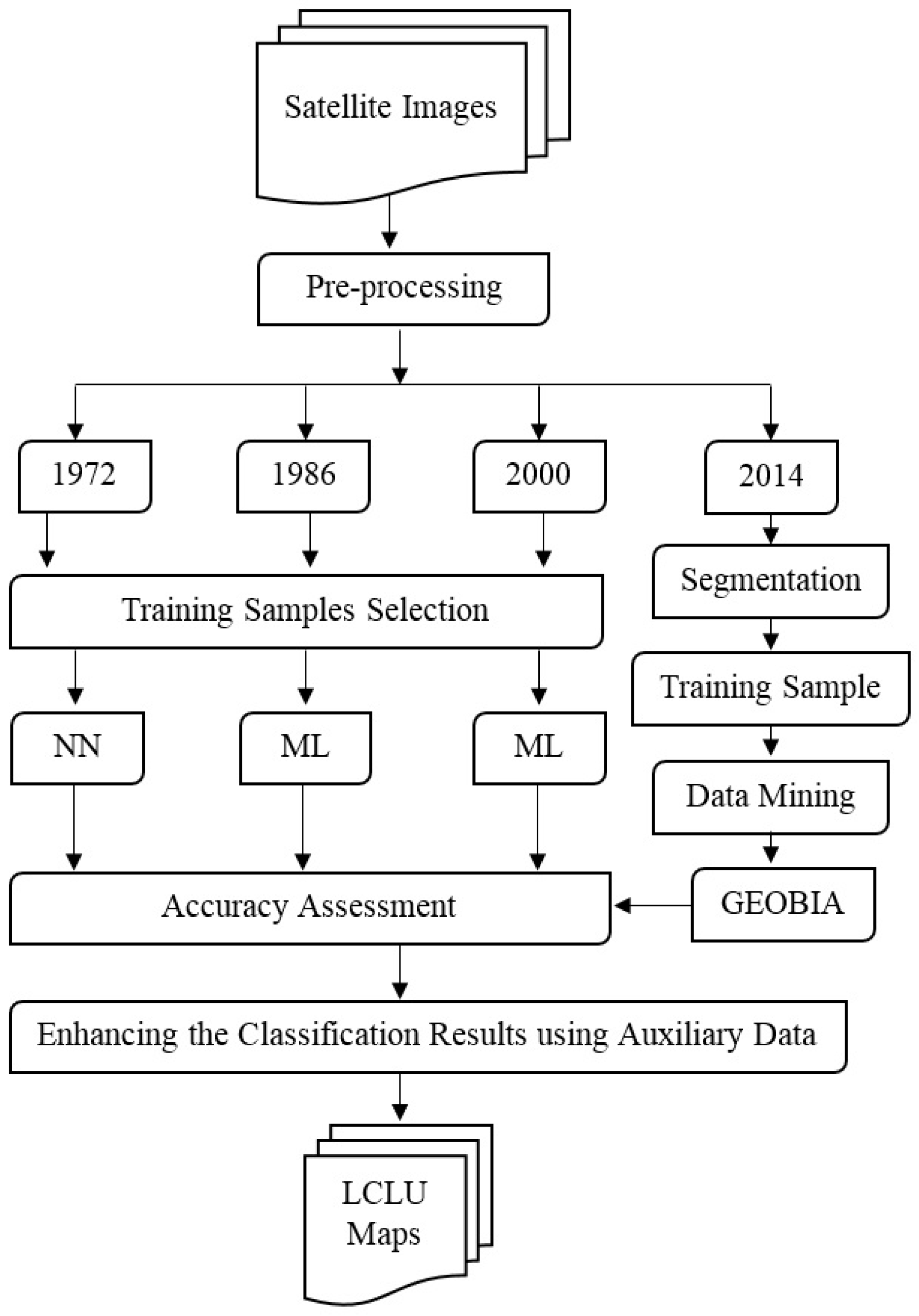
2. Materials and Methods
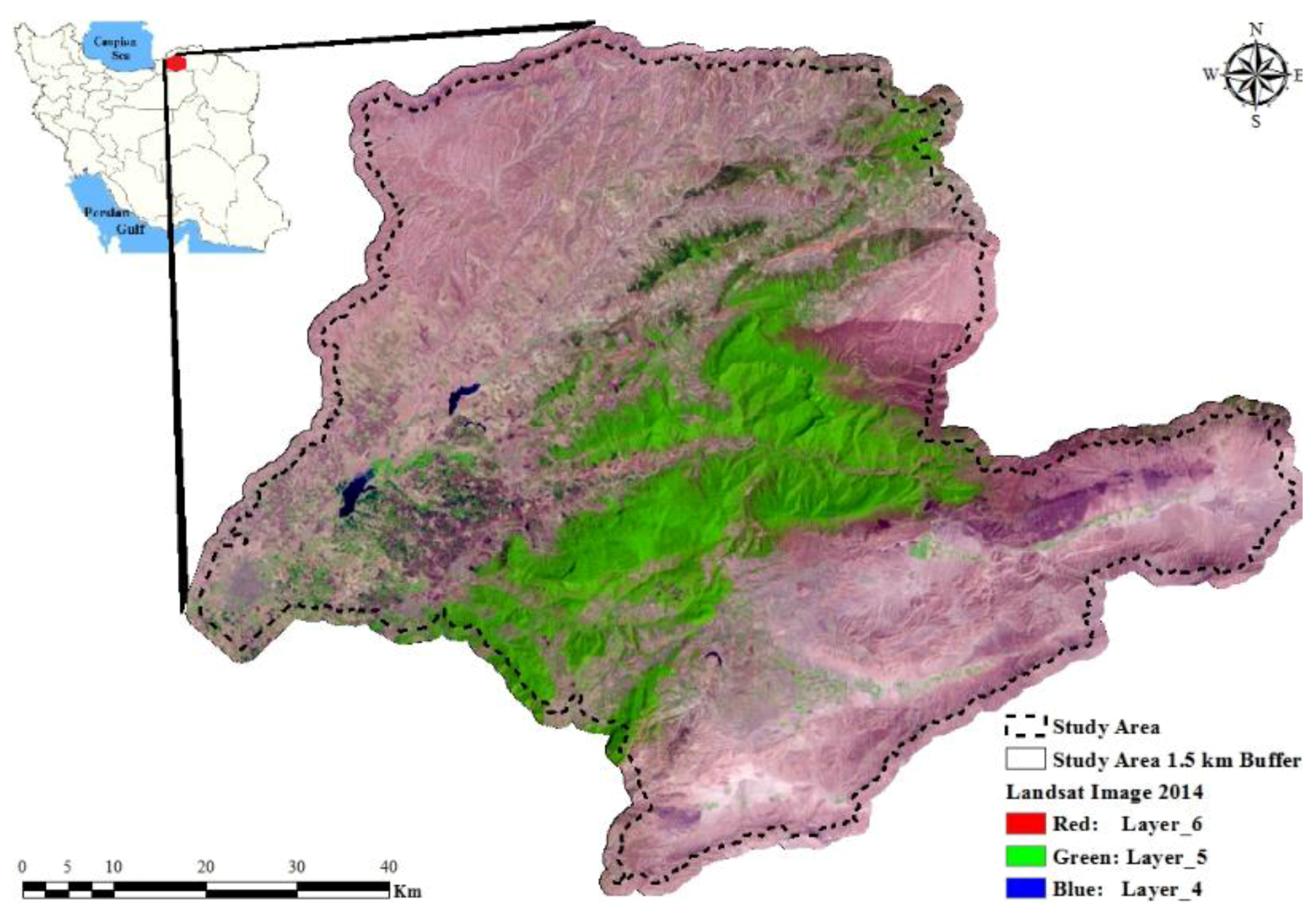
2.1. Study Area
2.2. Datasets
2.3. Image Preprocessing and Pan-Sharpening
2.4. Classification
2.4.1. Pixel-Based Classification
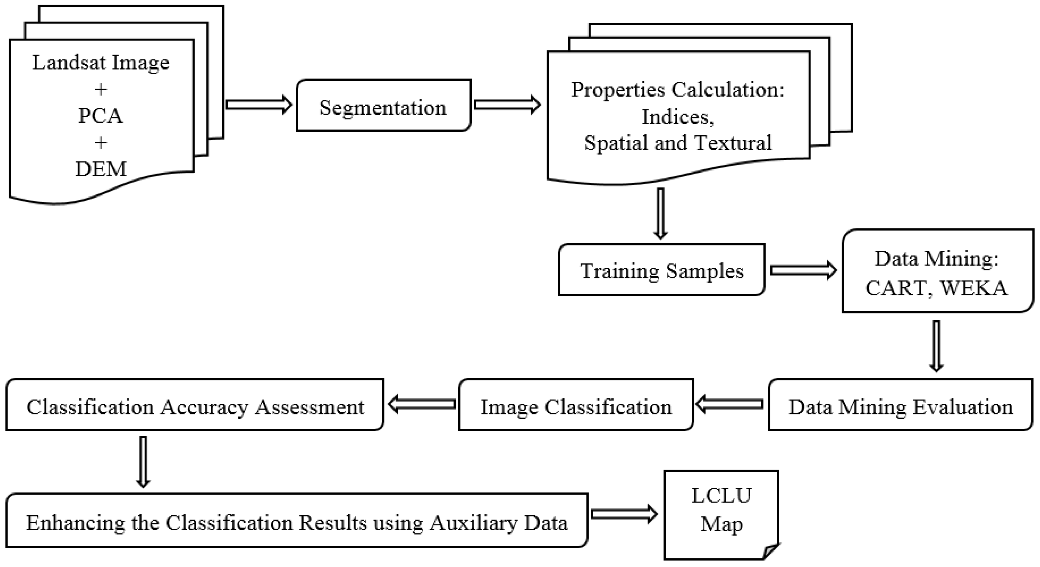
2.4.2. Geographic Object Based Image Analysis
Segmentation
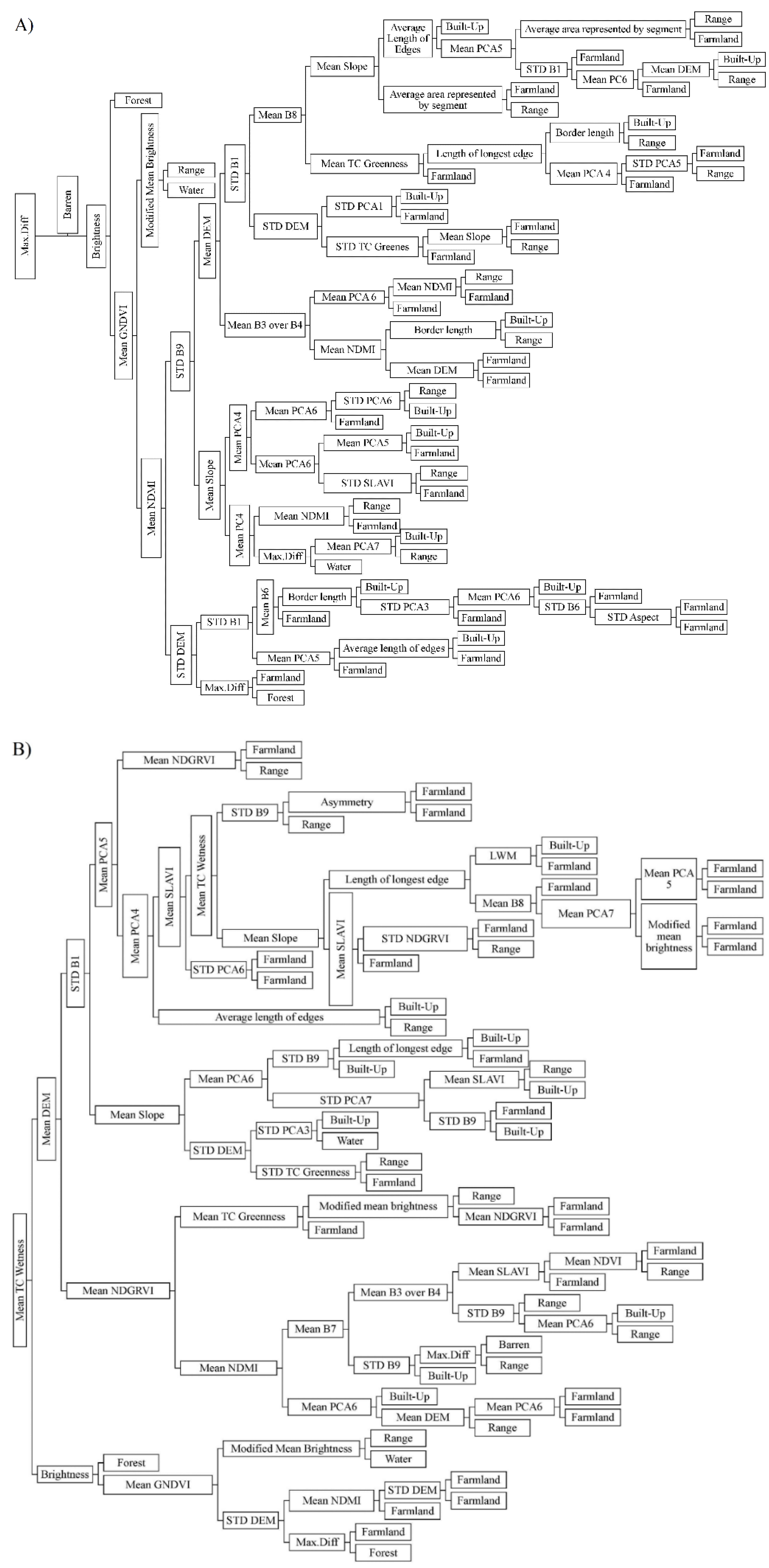
Data Mining
2.5. Accuracy Assessment
3. Results and Discussion
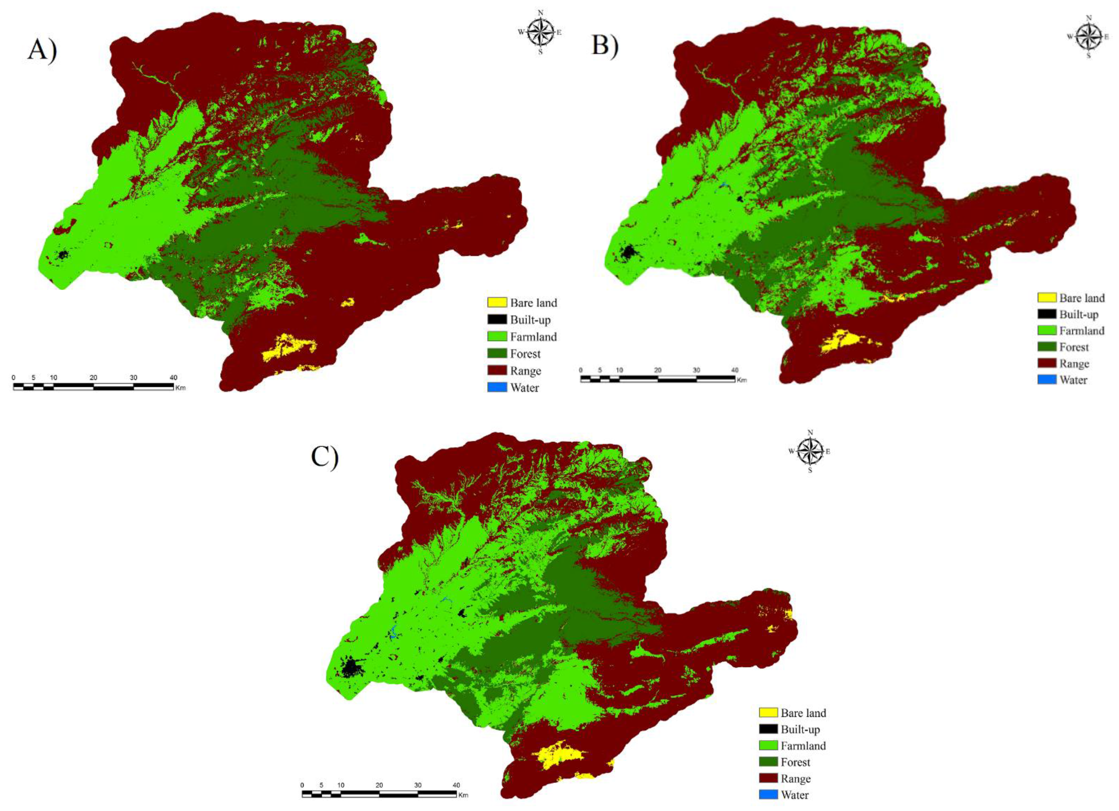
3.1. Pixel-Based classification
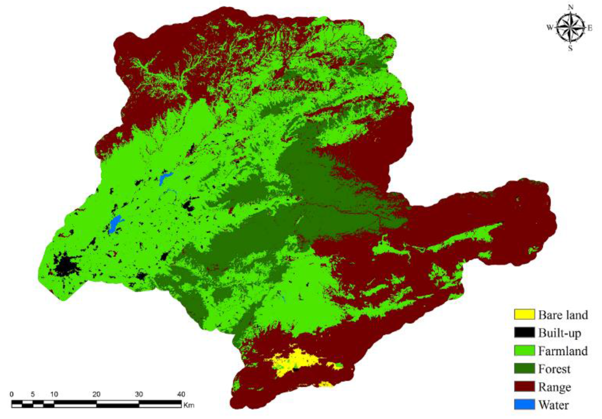
3.2. GEOBIA Classification
4. Conclusion
Acknowledgments
Author Contributions
Conflicts of Interest
References
- Thilagavathi, N.; Subramani, T.; Suresh, M. Land use/land cover change detection analysis in Salem Chalk Hills, South India using remote sensing and GIS. Disaster Adv. 2015, 8, 44–52. [Google Scholar]
- Adhikari, S.; Southworth, J.; Nagendra, H. Understanding forest loss and recovery: A spatiotemporal analysis of land change in and around Bannerghatta National Park, India. J. Land Use Sci. 2014, 10, 1–23. [Google Scholar] [CrossRef]
- Lambin, E.F.; Turner, B.L.; Geist, H.J; Agbola, S.B.; Angelsen, A.; Bruce, J.W.; Coomes, O.T.; Dirzo, R.; Fischer, J.; Folke, C.; et al. The causes of land-use and land-cover change: Moving beyond the myths. Glob. Environ. Chang. 2001, 11, 261–269. [Google Scholar] [CrossRef]
- Dingle Robertson, L.; King, D.J. Comparison of pixel- and object-based classification in land cover change mapping. Int. J. Remote Sens. 2011, 32, 1505–1529. [Google Scholar] [CrossRef]
- Chapin Iii, F.S.; Zavaleta, E.S.; Eviner, V.T.; Naylor, R.L.; Vitousek, P.M.; Reynolds, H.L.; Hooper, D.U.; Lavorel, S.; Sala, O.E.; Hobbie, S.E.; et al. Consequences of changing biodiversity. Nature 2000, 405, 234–242. [Google Scholar] [CrossRef] [PubMed]
- Berakhi, R.O.; Oyana, T.J.; Adu-Prah, S. Land use and land cover change and its implications in Kagera river basin, East Africa. Afr. Geogr. Rev. 2014, 34, 1–23. [Google Scholar] [CrossRef]
- Statistical-Center-of-Iran. Iranian Population and Housing Census 1385—Golestan Province General Results; Statistical-Center-of-Iran: Tehran, Iran, 2006. [Google Scholar]
- Qin, Y.; Niu, Z.; Chen, F.; Li, B.; Ban, Y. Object-based land cover change detection for cross-sensor images. Int. J. Remote Sens. 2013, 34, 6723–6737. [Google Scholar] [CrossRef]
- Yesmin, R.; Mohiuddin, A.S.M.; Uddin, M.J.; Shahid, M.A. Land use and land cover change detection at Mirzapur Union of Gazipur District of Bangladesh using remote sensing and GIS technology. In Proceedings of the IOP Conference Series: Earth and Environmental Science, Kuala Lumpur, Malaysia, 22–23 April 2014.
- Kolios, S.; Stylios, C.D. Identification of land cover/land use changes in the greater area of the Preveza peninsula in Greece using Landsat satellite data. Appl. Geogr. 2013, 40, 150–160. [Google Scholar] [CrossRef]
- Abd El-Kawy, O.R.; Rød, J.K.; Ismail, H.A.; Suliman, A.S. Land use and land cover change detection in the western Nile delta of Egypt using remote sensing data. Appl. Geogr. 2011, 31, 483–494. [Google Scholar] [CrossRef]
- Yang, X.; Lo, C.P. Using a time series of satellite imagery to detect land use and land cover changes in the Atlanta, Georgia metropolitan area. Int. J. Remote Sens. 2002, 23, 1775–1798. [Google Scholar] [CrossRef]
- Salman Mahini, A.; Feghhi, J.; Nadali, A.; Riazi, B. Tree cover change detection through Artificial Neural Network classification using Landsat TM and ETM+ images (case study: Golestan Province, Iran). Iran. J. For. Poplar Res. 2008, 16, 495–505. [Google Scholar]
- Saadat, H.; Adamowski, J.; Bonnell, R.; Sharifi, F.; Namdar, M.; Ale-Ebrahim, S. Land use and land cover classification over a large area in Iran based on single date analysis of satellite imagery. ISPRS J. Photogramm. Remote Sens. 2011, 66, 608–619. [Google Scholar] [CrossRef]
- Abbaszadeh Tehrani, N.; Makhdoum, M.F.; Mahdavi, M. Studying the impacts of land use changes on flood flows by using remote sensing(RS) and geographical information system (GIS) techniques—A case study in dough river watershed, Northeast of Iran. Environ. Res. 2011, 1, 1–14. [Google Scholar]
- Mallinis, G.; Koutsias, N.; Arianoutsou, M. Monitoring land use/land cover transformations from 1945 to 2007 in two peri-urban mountainous areas of Athens metropolitan area, Greece. Sci. Total Environ. 2014, 490, 262–278. [Google Scholar] [CrossRef] [PubMed]
- Lu, D.; Mausel, P.; Brondízio, E.; Moran, E. Change detection techniques. Int. J. Remote Sens. 2004, 25, 2365–2401. [Google Scholar] [CrossRef]
- Mohammadi, J.; Shataee, S. Possibility investigation of tree diversity mapping using Landsat ETM+ data in the Hyrcanian forests of Iran. Remote Sens. Environ. 2010, 114, 1504–1512. [Google Scholar] [CrossRef]
- Delbari, M.; Afrasiab, P.; Jahani, S. Spatial interpolation of monthly and annual rainfall in northeast of Iran. Meteorol. Atmos. Phys. 2013, 122, 103–113. [Google Scholar] [CrossRef]
- Lu, D.S.; Li, G.Y.; Kuang, W.H.; Moran, E. Methods to extract impervious surface areas from satellite images. Int. J. Digit. Earth 2014, 7, 93–112. [Google Scholar] [CrossRef]
- USGS. Using the USGS Landsat 8 Product. Available online: http://landsat.usgs.gov/Landsat8_Using_Product.php (accessed on 10 March 2015).
- USGS. How is Radiance Calculated? Available online: http://landsat.usgs.gov/how_is_radiance_calculated.php (accessed on 12 March 2016).
- Exelis VIS, p.d.c. Radiometric Calibration. Available online: http://www.exelisvis.com/docs/RadiometricCalibration.html (accessed on 12 March 2016).
- Chavez, P.S. Radiometric calibration of Landsat thematic mapper multispectral images. Photogramm. Eng. Remote Sens. 1989, 55, 1285–1294. [Google Scholar]
- Yuhendra; Alimuddin, I.; Sumantyo, J.T.S.; Kuze, H. Assessment of pan-sharpening methods applied to image fusion of remotely sensed multi-band data. Int. J. Appl. Earth Obs. Geoinform. 2012, 18, 165–175. [Google Scholar] [CrossRef]
- ArcGIS Help. Fundamentals of Panchromatic Sharpening. Available online: http://resources.arcgis.com/en/help/main/10.1/index.html#//009t000000mw000000 (accessed on 11 March 2015).
- Maurer, T. How to pan-sharpen images using the Gram-Schmidt pan-sharpen method-a recipe. Int. Arch. Photogramm. Remote Sens. Spat. Inf. Sci. 2013, XL-1/W1, 239–244. [Google Scholar] [CrossRef]
- Laben, C.A.; Brower, B.V. Process for Enhancing the Spatial Resolution of Multispectral Imagery using Pan-Sharpening. Google Patents US6011875 A, 2000. [Google Scholar]
- Blaschke, T. Object based image analysis for remote sensing. ISPRS J. Photogramm. Remote Sens. 2010, 65, 2–16. [Google Scholar] [CrossRef]
- Nutini, F.; Boschetti, M.; Brivio, P.A.; Bocchi, S.; Antoninetti, M. Land-use and land-cover change detection in a semi-arid area of Niger using multi-temporal analysis of Landsat images. Int. J. Remote Sens. 2013, 34, 4769–4790. [Google Scholar] [CrossRef]
- Wu, G.; Gao, Y.; Wang, Y.; Wang, Y.Y.; Xu, D. Land-use/land cover changes and their driving forces around wetlands in Shangri-La County, Yunnan Province, China. Int. J. Sustain. Dev. World Ecol. 2015, 22, 110–116. [Google Scholar] [CrossRef]
- Gao, Y.; Mas, J.F. A comparison of the performance of pixel based and object based classifications over images with various spatial resolutions. ISPRS Arch. 2008, XXXVIII-4/C1, 1–6. [Google Scholar]
- Addink, E.A.; van Coillie, F.M.B.; de Jong, S.M. Introduction to the GEOBIA 2010 special issue: From pixels to geographic objects in remote sensing image analysis. Int. J. Appl. Earth Obs. Geoinf. 2012, 15, 1–6. [Google Scholar] [CrossRef]
- Ma, L.; Cheng, L.; Li, M.; Liu, Y.; Ma, X. Training set size, scale, and features in geographic object-based image analysis of very high resolution unmanned aerial vehicle imagery. ISPRS J. Photogramm. Remote Sens. 2015, 102, 14–27. [Google Scholar] [CrossRef]
- Rabia, A.H.; Terribile, F. Semi-automated Classification of gray scale aerial photographs using geographic object based image analysis (GEOBIA) technique. In European Geosciences Union General Assembly-Geophysical Research Abstracts; Vienna, Austria, 2013. [Google Scholar]
- Blaschke, T.; Feizizadeh, B.; Holbling, D. Object-based image analysis and digital terrain analysis for locating landslides in the urmia lake basin, Iran. IEEE J. Sel. Top. Appl. Earth Obs. Remote Sens. 2014, 7, 4806–4817. [Google Scholar] [CrossRef]
- Witharana, C.; Civco, D.L.; Meyer, T.H. Evaluation of data fusion and image segmentation in earth observation based rapid mapping workflows. ISPRS J. Photogramm. Remote Sens. 2014, 87, 1–18. [Google Scholar] [CrossRef]
- Dragut, L.; Tiede, D.; Levick, S.R. ESP: A tool to estimate scale parameter for multiresolution image segmentation of remotely sensed data. Int. J. Geogr. Inf. Sci. 2010, 24, 859–871. [Google Scholar] [CrossRef]
- Wang, Z.; Jensen, J.R.; Im, J. An automatic region-based image segmentation algorithm for remote sensing applications. Environ. Model. Softw. 2010, 25, 1149–1165. [Google Scholar] [CrossRef]
- Lang, S. Object-based image analysis for remote sensing applications: Modeling reality–dealing with complexity. In Object-Based Image Analysis; Blaschke, T., Lang, S., Hay, G., Eds.; Springer: Berlin, Germany, 2008; pp. 3–27. [Google Scholar]
- Baatz, M.; Schäpe, M. Multiresolution segmentation. In Angewandte Geographische Informations-Verarbeitung; Strobl, J., Blaschke, T., Griesebner, G., Eds.; Wichmann Verlag: Karlsruhe, Germany, 2000; pp. 12–23. [Google Scholar]
- Vieira, M.A.; Formaggio, A.R.; Renno, C.D.; Atzberger, C.; Aguiar, D.A.; Mello, M.P. Object based image analysis and data mining applied to a remotely sensed Landsat time-series to map sugarcane over large areas. Remote Sens. Environ. 2012, 123, 553–562. [Google Scholar] [CrossRef]
- Hall, M.; Frank, E.; Holmes, G.; Pfahringer, B.; Reutemann, P.; Witten, I.H. The WEKA data mining software: An update. SIGKDD Explor. Newslett. 2009, 11, 10–18. [Google Scholar] [CrossRef]
- Breiman, L.; Friedman, J.; Olshen, R.; Stone, C. Classification and Regression Trees; Pacific Grove: Wadsworth, OH, USA, 1984. [Google Scholar]
- Steinberg, D.; Colla, P. Cart-Classification and Regression Tree; Salford Systems: San Diego, CA, USA, 1997. [Google Scholar]
- Dan Steinberg, M.G. CART 6.0 User’s Manual; Salford Systems: San Diego, CA, USA, 2006. [Google Scholar]
- Waheed, T.; Bonnell, R.B.; Prasher, S.O.; Paulet, E. Measuring performance in precision agriculture: CART—A decision tree approach. Agric. Water Manag. 2006, 84, 173–185. [Google Scholar] [CrossRef]
- Salford System. CART Classification and Regression Trees; Salford Systems: San Diego, CA, USA, 2015. [Google Scholar]
- Sharma, R.; Ghosh, A.; Joshi, P.K. Decision tree approach for classification of remotely sensed satellite data using open source support. J. Earth Syst. Sci. 2013, 122, 1237–1247. [Google Scholar] [CrossRef]
- Biswal, S.; Ghosh, A.; Sharma, R.; Joshi, P.K. Satellite data classification using open source support. J. Indian Soc. Remote Sens. 2013, 41, 523–530. [Google Scholar] [CrossRef]
- Kramer, S. J48. Available online: http://www.opentox.org/dev/documentation/components/j48/ (accessed on 12 March 2016).
- Waikato, M.L.G. Weka 3: Data Mining Software in Java. Available online: http://www.cs.waikato.ac.nz/~ml/weka/ (accessed on 12 March 2016).
- Pontius, R.G., Jr.; Millones, M. Death to Kappa: Birth of quantity disagreement and allocation disagreement for accuracy assessment. Int. J. Remote Sens. 2011, 32, 4407–4429. [Google Scholar] [CrossRef]
- Cordeiro, C.L.D.; Rossetti, D.D. Mapping vegetation in a late quaternary landform of the Amazonian wetlands using object-based image analysis and decision tree classification. Int. J. Remote Sens. 2015, 36, 3397–3422. [Google Scholar] [CrossRef]
- Mansour, K.; Mutanga, O.; Adam, E.; Abdel-Rahman, E.M. Multispectral remote sensing for mapping grassland degradation using the key indicators of grass species and edaphic factors. Geocarto Int. 2016, 31. [Google Scholar] [CrossRef]


| Data Name | Acquisition Date | Resolution | Full Area Coverage | Source |
|---|---|---|---|---|
| Landsat/MSS | 20 September 1972 | 60 m | Yes | http://earthexplorer.usgs.gov/ |
| Landsat/TM | 19 May 1986 | 30 m | Yes | http://earthexplorer.usgs.gov/ |
| Landsat ETM+ | 20 July 2000 | 30 m (Pan 15) | Yes | http://earthexplorer.usgs.gov/ |
| Landsat OLI/TIRS | 19 July 2014 | 30 m (Pan 15) | Yes | http://earthexplorer.usgs.gov/ |
| Aster | 18 July 2001 | 15 m | No | http://reverb.echo.nasa.gov/ |
| CORONA | 27 May 1970 | ~2.1 m | No | http://earthexplorer.usgs.gov/ |
| Quickbird | 2005 | 0.6 m | No | Geography Department, Ferdowsi University of Mashhad |
| Aerial Photo | 1970 | ~1.9 m | No | Geography Department, University of Tehran |
| DEM (Aster) | 30 m | Yes | http://earthexplorer.usgs.gov/ | |
| Topographic Map | No | Geography Department, University of Tehran | ||
| GIS Thematic Maps | Yes/No | Department of Natural Resource and Watershed Management, Golestan | ||
| Google/Yahoo/Bing Historical and up to Date Images | Yes/No | Internet |
| Image | Classification Method | Classifier |
|---|---|---|
| 1972 | Pixel-based | Neural Network |
| 1986 | Pixel-based | Maximum Likelihood |
| 2000 | Pixel-based | Maximum Likelihood |
| 2014 | Object-Based | Rule-based |
| Name of Attributes | Name of Attributes | Name of Attributes |
|---|---|---|
| Mean and STDDEV of B1 | Mean and STDDEV of B5-OVER-B4 | Brightness |
| Mean and STDDEV of B2 | Mean and STDDEV of B4-OVER-B6 | Max Diff |
| Mean and STDDEV of B3 | Mean and STDDEV of B4-OVER-B5 | Modified mean brightness |
| Mean and STDDEV of B4 | Mean and STDDEV of B3-OVER-B4 | Elliptic fit |
| Mean and STDDEV of B5 | Mean and STDDEV of DEM | Compactness |
| Mean and STDDEV of B6 | Mean and STDDEV of ASPECT | Width |
| Mean and STDDEV of B7 | Mean and STDDEV of SLOPE | Asymmetry |
| Mean and STDDEV of B8 | STDDEV of area represented by segments | Density |
| Mean and STDDEV of B9 | Length width only main line | Rectangular fit |
| Mean and STDDEV of PCA1 | Relative border to image border | Length |
| Mean and STDDEV of PCA2 | Average area represented by segment | Length width |
| Mean and STDDEV of PCA3 | STDDEV curvature only main line | Average branch length |
| Mean and STDDEV of PCA4 | Length of longest edge (polygon) | Volume |
| Mean and STDDEV of PCA5 | Average length of edges (polygon) | Perimeter (polygon) |
| Mean and STDDEV of PCA6 | Polygon self-intersection (polygon) | Length thickness |
| Mean and STDDEV of PCA7 | Radius of smallest enclosing ellipse | Shape index |
| Mean and STDDEV of TC Wetness | Area excluding inner polygons | Thickness |
| Mean and STDDEV of TC Greenness | Length of main line regarding cycles | Number of segments |
| Mean and STDDEV of TC Brightness | Area including inner polygons | Maximum branch length |
| Mean and STDDEV of SLAVI | Number of inner objects (polygon) | Area |
| Mean and STDDEV of NDVI | STDDEV of length of edges (polygon) | Border index |
| Mean and STDDEV of NDMI | Radius of largest enclosed ellipse | Width only main line |
| Mean and STDDEV of NDGRVI | Degree of skeleton branching | Compactness (polygon) |
| Mean and STDDEV of NDBI | Length of main line no cycle | Number of pixels |
| Mean and STDDEV of LWM | Curvature length only main line | Roundness |
| Mean and STDDEV of GNDVI | Border Length | Main direction |
| Mean and STDDEV of B7-OVER-B3 | Number of edges (polygon) |
| Image | Classifier | Overall Accuracy | Quantity Disagreement (%) | Allocation Disagreement (%) |
|---|---|---|---|---|
| 1972 | Neural Network | 95.9 | 2.4 | 2.2 |
| 1986 | Maximum Likelihood | 89.8 | 6.6 | 2.5 |
| 2000 | Maximum Likelihood | 91.3 | 6 | 2.7 |
| Attributes | CART | WEKA | Attributes | CART | WEKA |
|---|---|---|---|---|---|
| STDDEV of B1 | √ | √ | Mean and STDDEV of B6 | √ | - |
| Mean of B8 | √ | √ | Mean and STDDEV of PCA6 | √ | √ |
| STDDEV of B9 | √ | √ | Mean and STDDEV of TC Greenness | √ | √ |
| STDDEV of PCA1 | √ | - | Mean of B3-OVER-B4 | √ | √ |
| STDDEV of PCA3 | √ | √ | Mean and STDDEV of DEM | √ | √ |
| Mean of PCA4 | √ | √ | STDDEV of ASPECT | √ | - |
| Mean of PCA5 | √ | √ | Average area represented by segment | √ | - |
| STDDEV of PCA5 | √ | - | Length of longest edge (polygon) | √ | √ |
| Mean of PCA7 | √ | √ | Average length of edges (polygon) | √ | √ |
| STDDEV of PCA7 | - | √ | Mean and STDDEV of NDGRVI | - | √ |
| STDDEV of SLAVI | √ | √ | Brightness | √ | √ |
| Mean of NDMI | √ | √ | Max Diff | √ | √ |
| Mean of GNDVI | √ | √ | Modified mean brightness | √ | √ |
| Mean of SLOPE | √ | √ | Border Length | √ | - |
| Mean of TC Wetness | - | √ | Mean of B7 | - | √ |
| Asymmetry | - | √ | Mean of NDVI | - | √ |
| Mean LWM | - | √ |
| Image | Data Miner | Overall Accuracy | Quantity Disagreement (%) | Allocation Disagreement (%) |
|---|---|---|---|---|
| 2014 | WEKA (J48) | 94.05 | 2.1 | 2.1 |
| 2014 | CART (GINI) | 94.03 | 3.5 | 2.5 |
| LCLU Class | 1972 | 1986 | 2000 | 2014 | ||||
|---|---|---|---|---|---|---|---|---|
| Area (ha) | (%) | Area (ha) | (%) | Area (ha) | (%) | Area (ha) | (%) | |
| Bare Land | 4404.78 | 0.70 | 4084.52 | 0.65 | 5759.80 | 0.92 | 4305.24 | 0.69 |
| Built-up | 819.07 | 0.13 | 2646.88 | 0.42 | 5050.67 | 0.81 | 9057.29 | 1.45 |
| Farmland | 125,379.09 | 20.02 | 182,633.27 | 29.16 | 224,809.31 | 35.90 | 255,753.59 | 40.84 |
| Forest | 122,614.20 | 19.58 | 119,333.86 | 19.06 | 106,020.83 | 16.93 | 106,267.82 | 16.97 |
| Range | 372,998.45 | 59.56 | 317,440.78 | 50.69 | 284,351.40 | 45.41 | 249,663.40 | 39.87 |
| Water | 20.57 | 0.00 | 96.95 | 0.02 | 244.28 | 0.04 | 1,188.97 | 0.19 |
| 1972/2014 | Bareland | Built-Up | Farmland | Forest | Range | Water |
|---|---|---|---|---|---|---|
| Bare Land | 510,780.94 | 11,091.94 | 108,636.19 | 0.00 | 360,566.44 | 0.00 |
| Built-Up | 0.00 | 183,500.44 | 263.25 | 0.00 | 0.00 | 526.50 |
| Farmland | 0.00 | 1,347,779.25 | 26,545,861.69 | 17,177.06 | 71,649.56 | 227,827.69 |
| Forest | 0.00 | 30,243.38 | 4,759,347.38 | 22,014,225.56 | 782,257.50 | 2,121.19 |
| Range | 457,898.06 | 465,264.00 | 26,129,653.31 | 1,878,855.75 | 54,959,785.88 | 33,194.81 |
| Water | 0.00 | 0.00 | 779.63 | 0.00 | 0.00 | 3,847.50 |
© 2016 by the authors; licensee MDPI, Basel, Switzerland. This article is an open access article distributed under the terms and conditions of the Creative Commons Attribution (CC-BY) license (http://creativecommons.org/licenses/by/4.0/).
Share and Cite
Minaei, M.; Kainz, W. Watershed Land Cover/Land Use Mapping Using Remote Sensing and Data Mining in Gorganrood, Iran. ISPRS Int. J. Geo-Inf. 2016, 5, 57. https://doi.org/10.3390/ijgi5050057
Minaei M, Kainz W. Watershed Land Cover/Land Use Mapping Using Remote Sensing and Data Mining in Gorganrood, Iran. ISPRS International Journal of Geo-Information. 2016; 5(5):57. https://doi.org/10.3390/ijgi5050057
Chicago/Turabian StyleMinaei, Masoud, and Wolfgang Kainz. 2016. "Watershed Land Cover/Land Use Mapping Using Remote Sensing and Data Mining in Gorganrood, Iran" ISPRS International Journal of Geo-Information 5, no. 5: 57. https://doi.org/10.3390/ijgi5050057
APA StyleMinaei, M., & Kainz, W. (2016). Watershed Land Cover/Land Use Mapping Using Remote Sensing and Data Mining in Gorganrood, Iran. ISPRS International Journal of Geo-Information, 5(5), 57. https://doi.org/10.3390/ijgi5050057