

Evaluation of the Consistency of MODIS Land Cover Product (MCD12Q1) Based on Chinese 30 m GlobeLand30 Datasets: A Case Study in Anhui Province, China
Abstract
:1. Introduction

| Dataset | Available Years | Spatial Resolution |
|---|---|---|
| IGBP-DISCover | 1992–1993 | 1 km |
| UMD LC | 1992–1993 | 1 km |
| CORINE | 1990–2000 | 100 m |
| MCD12Q1 | 2001–2012 | 500 m |
| GLC2000 | 1999–2000 | 1 km |
| GlobCover | 2005, 2009 | 300 m |
| ECOCLIMAP | 1999–2005 | 1 km |
| GlobeLand30 | 2000, 2010 | 30 m |
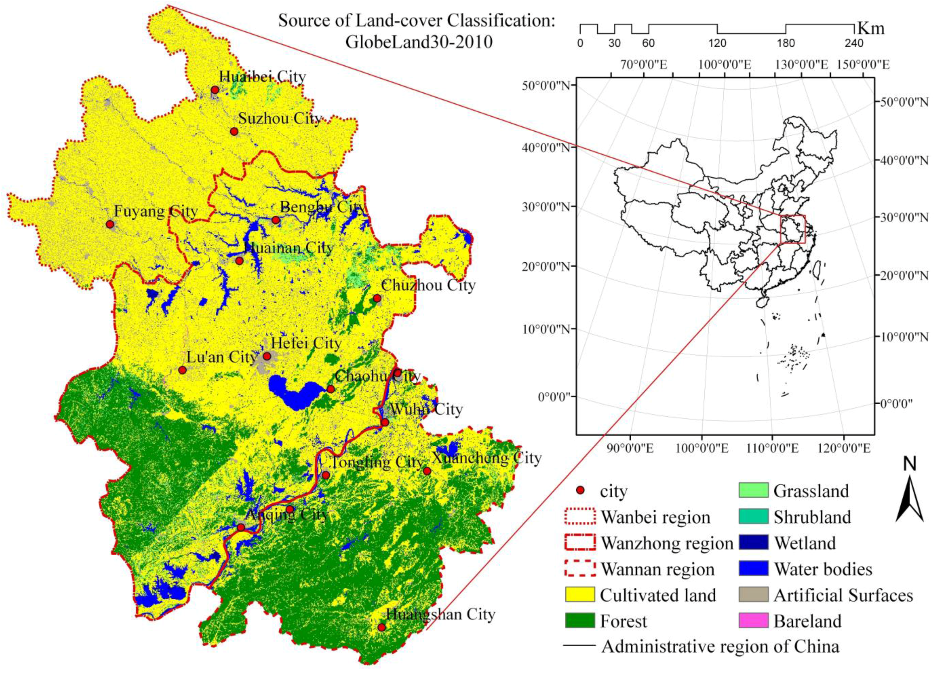
2. Study Area
3. Data Sources and Preprocessing
| Item | MCD12Q1 | GlobeLand30 |
|---|---|---|
| Data Format | HDF-EOS | Geotiff |
| Projection | Sinusoidal | UTM |
| Total Accuracy | 74.8% ± 1.3% | 83.5% |
| Acquisition website | http://reverb.echo.nasa.gov | http://www.globallandcover.com |
3.1. MODIS Dataset
3.2. GlobeLand30 Data
3.3. Data Preprocessing
| Type | Definition |
|---|---|
| Cultivated land | Lands used for agriculture, horticulture and gardens, including paddy fields, irrigated and dry farmlands, vegetation and fruit gardens. |
| Forest | Lands with trees, with vegetation cover over 30%, including deciduous and coniferous forests, and sparse woodlands with cover from 10% to 30%, etc. |
| Grassland | Lands covered with shrubs with cover over 10%, etc. |
| Shrubland | Land with shrubs cover over 30%, including deciduous and evergreen shrubs and deserts steppe with cover over 10%, etc. |
| Wetland | Lands covered with wetlands plants and water bodies, including inland marsh, lake marsh, river floodplain wetland, forest/shrub wetland, peat bogs, mangrove and salt marsh, etc. |
| Water bodies | Water bodies in the land area, including river, lake, reservoir and fish pond, etc. |
| Tundra | Lands covered by lichen, moss, hardy perennial herb and shrubs in the polar regions, including shrub tundra, herbaceous tundra, wet tundra and barren tundra, etc. |
| Artificial surfaces | Lands modified by human activities, including the various habitation, industrial and mining area, transportation facilities, and interior urban green zones and water bodies, etc. |
| Barren land | Lands with vegetation cover lower than 10%, including desert, sandy fields, Gobi, bare rocks, saline and alkaline lands, etc. |
| Permanent snow and ice | Lands covered by permanent snow, glacier and icecap. |
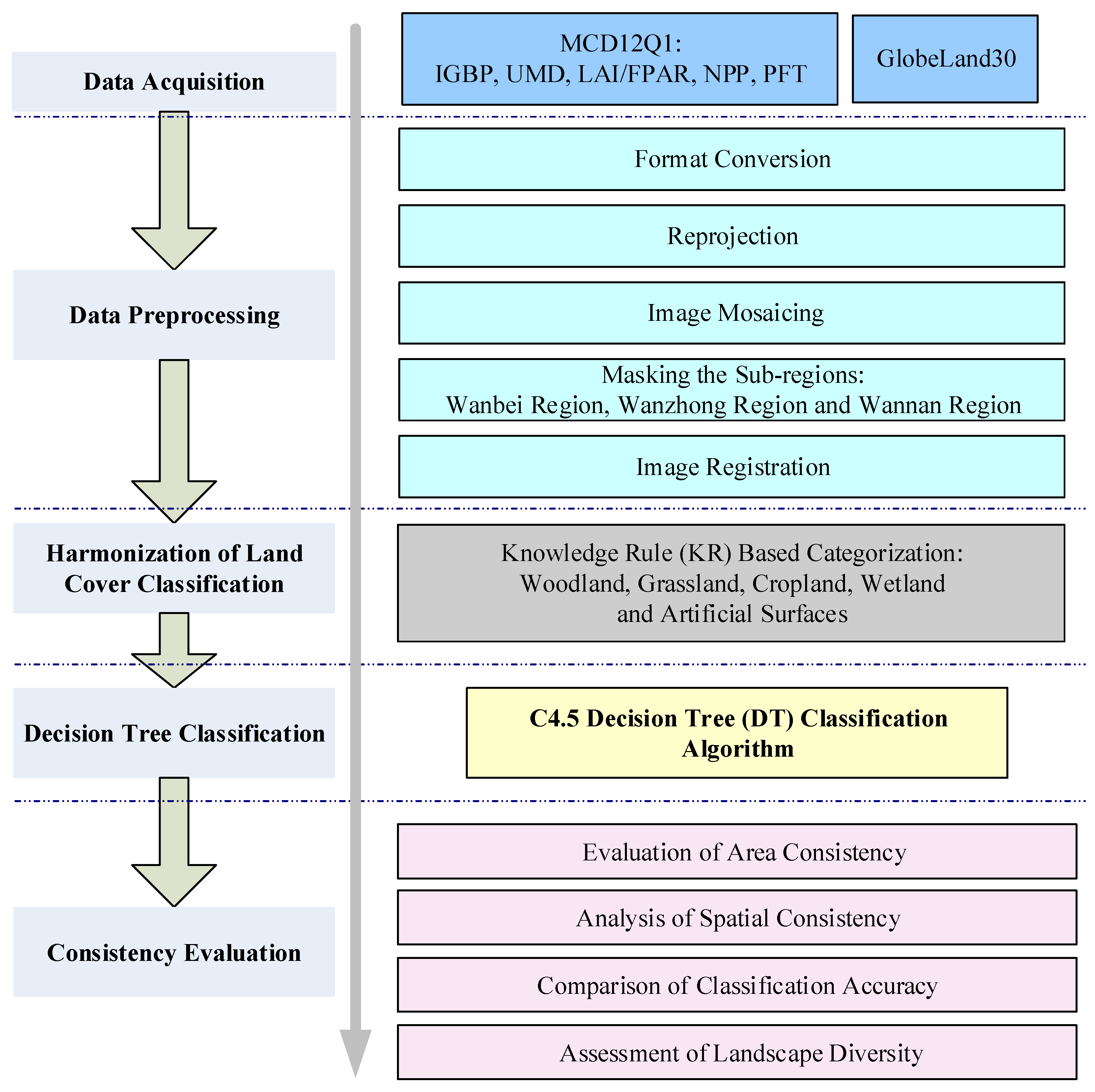
4. Outline and Methodology
4.1. Arrangement of Sections
4.2. Harmonization of Land Cover Classification
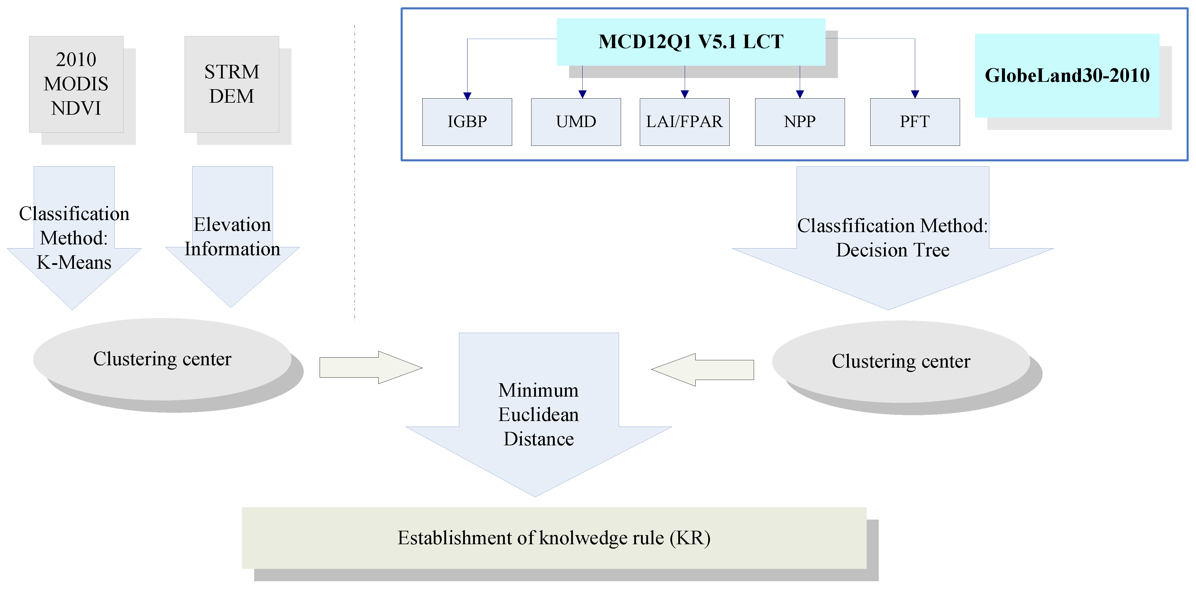
| Type | IGBP | UMD | LAI/FPAR | NPP | PFT | GlobeLand30 |
|---|---|---|---|---|---|---|
| Woodland | 1. Evergreen Needleleaf forest | 1. Evergreen Needleleaf forest | 1. Shrubs | 1. Evergreen Needleleaf vegetation | 1. Evergreen Needleleaf trees | 1. Forest |
| 2. Evergreen Broadleaf forest | 2. Evergreen Broadleaf forest | 2. Broadleaf forest | 2. Evergreen Broadleaf vegetation | 2. Evergreen Broadleaf trees | 2. Shrubland | |
| 3. Deciduous Needleleaf forest | 3. Deciduous Needleleaf forest | 3. Needleleaf forest | 3. Deciduous Needleleaf vegetation | 3. Deciduous Needleleaf trees | ||
| 4. Deciduous Broadleaf forest | 4. Deciduous Broadleaf forest | 4. Deciduous Broadleaf vegetation | 4. Deciduous Broadleaf trees | |||
| 5. Mixed forests | 5. Mixed forests | 5. Shrub | ||||
| 6. Closed shrublands | 6. Closed shrublands | |||||
| 7. Open shrublands | 7. Open shrublands | |||||
| Grassland | 1. Woody savannas | 1. Woody savannas | 1. Grasses/Cereal crops | 1. Annual Broadleaf vegetation | 1. Grass | 1. Grassland |
| 2. Savannas | 2. Savannas | 2. Savannas | 2. Annual grass vegetation | |||
| 3. Grasslands | 3. Grasslands | |||||
| Cropland | 1. Croplands | 1. Croplands | 1. Broadleaf crops | 1. Cereal crops | 1. Cultivated land | |
| 2. Croplands/Natural vegetation | 2. Broad-leaf crops | |||||
| Wetland | 1. Water bodies | 1. Water bodies | 1. Water bodies | 1. Water bodies | 1. Water bodies | 1. Water bodies |
| 2. Permanent wetlands | 2. Snow and ice | 2. Wetland | ||||
| 3. Snow and ice | 3. Permanent snow and ice | |||||
| Artificial Surfaces | 1. Urban and built-up | 1. Urban and built-up | 1. Urban | 1. Urban | 1. Urban and built-up | 1. Artificial Surfaces |
| Others | 1. Barren or sparsely vegetated | 1. Barren or sparsely vegetated | 1. Non-vegetated land | 1. Non-vegetated land | 1. Barren or sparse vegetation | 1. Barren land |
4.3. C4.5 Decision Tree Classification
4.4. Evaluation of Consistency
4.4.1. Area Consistency
4.4.2. Spatial Consistency
4.4.3. Accuracy Verification
4.4.4. Landscape Diversity
5. Results and Discussion
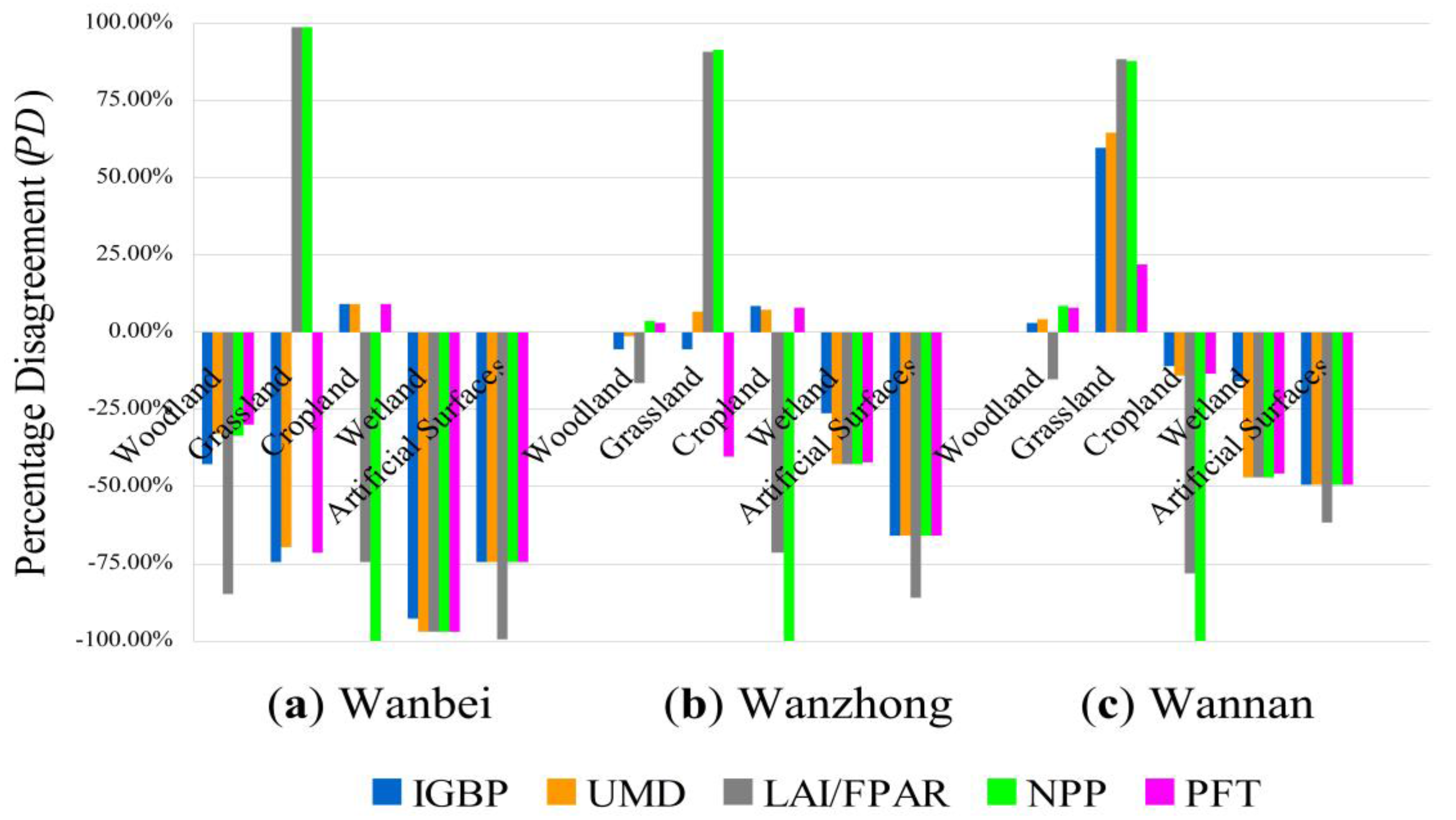
5.1. Validation of Classification Accuracy of GlobeLand30
| Region | Land Cover Type | Area (km2) | Yearbook Statistics | Fractional Error (%) |
|---|---|---|---|---|
| Anhui Province | Woodland | 36711.25 | 38042.20 | 3.50 |
| Cropland | 82294.50 | 90865.91 | 9.43 | |
| Wetland | 7346.50 | 10418.00 | 29.48 | |
| Wanbei | Woodland | 106.25 | 5628.60 | 98.11 |
| Cropland | 25786.00 | 35316.03 | 26.98 | |
| Wetland | 326.00 | 1230.47 | 73.51 | |
| Wanzhong | Woodland | 15549.50 | 14104.50 | 10.24 |
| Cropland | 44284.50 | 45209.74 | 2.05 | |
| Wetland | 5610.25 | 6271.95 | 10.55 | |
| Wannan | Woodland | 21056.75 | 18309.10 | 15.01 |
| Cropland | 12239.50 | 10340.14 | 18.37 | |
| Wetland | 1416.00 | 2915.58 | 51.43 |
5.2. Evaluation of Area Consistency
| Region | IGBP (%) | UMD (%) | LAI/FPAR (%) | NPP (%) | PFT (%) |
|---|---|---|---|---|---|
| Wanbei | 98.44 | 98.43 | −17.78 | −31.47 | 98.43 |
| Wanzhong | 99.61 | 99.58 | −28.02 | −42.55 | 99.80 |
| Wannan | 98.22 | 97.27 | 56.40 | 69.26 | 97.98 |
| Anhui Province | 99.35 | 99.27 | −27.89 | −38.72 | 99.53 |

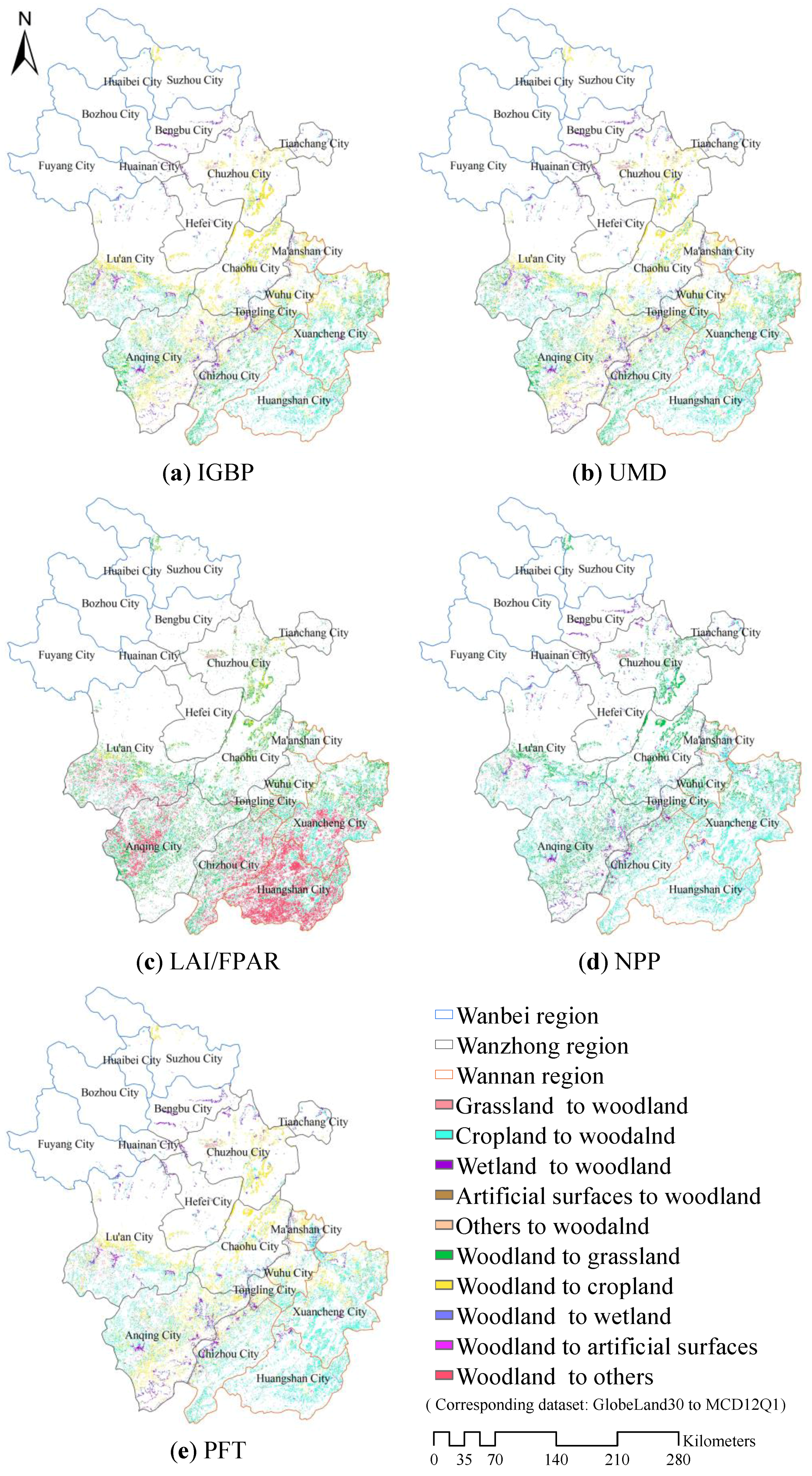
5.3. Analysis of Spatial Consistency
| Classification Schemes | IGBP | UMD | LAI/FPAR | NPP | PFT |
|---|---|---|---|---|---|
| Spatial Similarity O (%) | 78.66 | 80.62 | 58.17 | 86.70 | 85.68 |
5.4. Comparison of Classification Accuracy
| Land cover type (%) | IGBP | UMD | LAI/FPAR | NPP | PFT | ||||||
|---|---|---|---|---|---|---|---|---|---|---|---|
| Wanbei | Woodland | 1.75 | 0.74 | 1.46 | 0.74 | 9.38 | 0.74 | 1.49 | 0.74 | 1.40 | 0.74 |
| Grassland | 2.02 | 0.29 | 10.00 | 0.29 | 0.50 | 78.46 | 0.56 | 97.29 | 0.90 | 0.14 | |
| Cropland | 81.99 | 98.19 | 82.00 | 98.20 | 80.00 | 11.92 | 0 | 0 | 82.01 | 98.18 | |
| Wetland | 57.78 | 2.10 | 64.00 | 1.30 | 64.00 | 1.37 | 64 | 1.29 | 64.00 | 1.29 | |
| Artificial Surfaces | 42.42 | 6.24 | 42.42 | 6.26 | 8.47 | 0.02 | 42.42 | 6.24 | 42.42 | 6.24 | |
| OA = 80.82% | OA = 80.86% | OA = 10.23% | OA = 1.61% | OA = 80.80% | |||||||
| K = 6.88 | K = 6.73 | K = −0.30 | K = 0.66 | K = 6.91 | |||||||
| Wanzhong | Woodland | 74.50 | 66.40 | 71.20 | 69.38 | 78.27 | 56.06 | 70.17 | 75.89 | 70.03 | 74.78 |
| Grassland | 5.02 | 4.47 | 5.22 | 4.95 | 2.49 | 52.28 | 2.82 | 65.49 | 5.07 | 2.15 | |
| Cropland | 77.26 | 91.1 | 78.15 | 91.02 | 71.60 | 11.98 | 0 | 0 | 78.09 | 90.84 | |
| Wetland | 71.65 | 42.25 | 88.60 | 37.10 | 88.60 | 37.88 | 88.60 | 36.25 | 88.04 | 36.53 | |
| Artificial Surfaces | 48.34 | 10.04 | 48.30 | 10.28 | 4.49 | 0.39 | 48.30 | 10.04 | 48.30 | 10.04 | |
| OA = 73.76% | OA = 74.15% | OA = 23.97% | OA = 21.68% | OA = 74.89% | |||||||
| K = 49.11 | K = 49.86 | K = 13.62 | K = 15.33 | K = 51.25 | |||||||
| Wannan | Woodland | 80.89 | 85.86 | 79.98 | 87.30 | 79.60 | 58.43 | 77.55 | 92.56 | 77.73 | 91.62 |
| Grassland | 4.10 | 15.69 | 3.98 | 16.72 | 3.01 | 48.02 | 2.84 | 41.36 | 4.29 | 6.52 | |
| Cropland | 72.49 | 58.1 | 74.34 | 56.81 | 68.96 | 8.49 | 0 | 0 | 74.23 | 57.10 | |
| Wetland | 53.64 | 36.99 | 84.34 | 29.72 | 84.34 | 30.95 | 84.34 | 28.39 | 83.36 | 28.86 | |
| Artificial Surfaces | 57.38 | 19.24 | 57.32 | 20.93 | 4.60 | 1.29 | 57.32 | 19.24 | 57.32 | 19.24 | |
| OA = 71.77% | OA = 71.99% | OA = 39.32% | OA = 56.23% | OA = 74.29% | |||||||
| K = 48.33 | K = 47.92 | K = 16.36 | K = 25.72 | K = 49.74 | |||||||
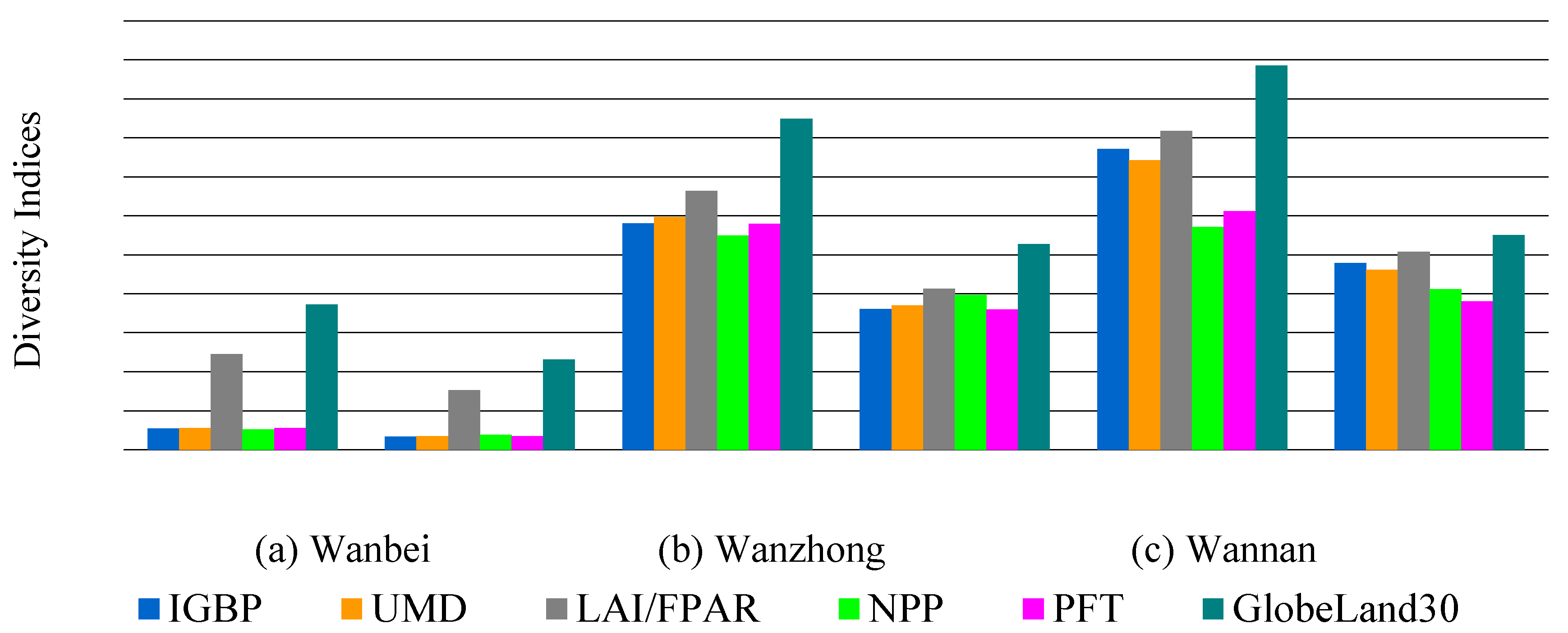
5.5. Assessment of Landscape Diversity
6. Conclusions
Acknowledgments
Author Contributions
Conflicts of Interest
References
- Pervez, M.S.; Henebry, G.M. Assessing the impacts of climate and land use and land cover change on the freshwater availability in the Brahmaputra River basin. J. Hydrol. Region. Stud. 2015, 3, 285–311. [Google Scholar] [CrossRef]
- Clerici, N.; Paracchini, M.L.; Maes, J. Land-cover change dynamics and insights into ecosystem services in European stream riparian zones. Ecohydrol. Hydrobiol. 2014, 14, 107–120. [Google Scholar] [CrossRef]
- Maitre, D.C.L.; Kotzee, I.M.; O’Farrell, P.J. Impacts of land-cover change on the water flow regulation ecosystem service: Invasive alien plants, fire and their policy implications. Land Use Policy 2014, 36, 171–181. [Google Scholar] [CrossRef]
- Pomara, L.Y.; Ledee, O.E.; Martin, K.J.; Zuckerberg, B. Demographic consequences of climate change and land cover help explain a history of extirpations and range contraction in a declining snake species. Glob. Chang. Biol. 2014, 20, 2087–2099. [Google Scholar] [CrossRef] [PubMed]
- Nagy, R.C.; Lockaby, B.G.; Zipperer, W.C.; Marzen, L.J. A comparison of carbon and nitrogen stocks among land uses/covers in coastal Florida. Urban Ecosys. 2014, 17, 255–276. [Google Scholar] [CrossRef]
- Herold, M.; Woodcock, C.E.; Gregorio, A.D.; Mayaux, P.; Belward, A.S.; Latham, J.; Schmullius, C.C. A joint initiative for harmonization and validation of land cover datasets. IEEE T. Geosci. Remote Sens. 2006, 44, 1719–1727. [Google Scholar] [CrossRef]
- See, L.M.; Fritz, S. A method to compare and improve land cover datasets: application to the GLC-2000 and MODIS land cover products. IEEE Trans. Geosci. Remote Sens. 2006, 44, 1740–1746. [Google Scholar] [CrossRef]
- Herold, M.; Mayaux, P.; Woodcock, C.E.; Baccini, A.; Schmullius, C. Some challenges in global land cover mapping: An assessment of agreement and accuracy in existing 1 km datasets. Remote Sens. Environ. 2008, 112, 2538–2556. [Google Scholar] [CrossRef]
- Tchuenté, A.T.K.; Roujean, J.L.; De Jong, S.M. Comparison and relative quality assessment of the GLC2000, GLOBCOVER, MODIS and ECOCLIMAP land cover data sets at the African continental scale. Int. J. Appl. Earth Obs. 2011, 13, 207–219. [Google Scholar] [CrossRef]
- Pérez-Hoyos, A.; García-Haro, F.J.; San-Miguel-Ayanz, J. Conventional and fuzzy comparisons of large scale land cover products: application to CORINE, GLC2000, MODIS and GlobCover in Europe. ISPRS J. Photogramm. Remote Sens. 2012, 74, 185–201. [Google Scholar] [CrossRef]
- Pérez-Hoyos, A.; García-Haro, F.J.; Valcarcel, N. Incorporating sub-dominant classes in the accuracy assessment of large-area land cover products: application to GlobCover, MODISLC, GLC2000 and CORINE in Spain. IEEE J. Sel. Top. Appl. Earth Obs. 2014, 1, 187–205. [Google Scholar] [CrossRef]
- Congalton, R.G.; Gu, J.; Yadav, K.; Ozdogan, M. Global land cover mapping: A review and uncertainty analysis. Remote Sens. 2014, 6, 12070–12093. [Google Scholar] [CrossRef]
- Mora, B.; Tsendbazar, N.E.; Herold, M.; Arino, O. Global land cover mapping: Current status and future trends. In Land Use & Land Cover Mapping in Europe; Manakos, I., Braun, M., Eds.; Springer: Dordrecht, The Netherlands, 2014; pp. 11–30. [Google Scholar]
- Loveland, T.R.; Belward, A.S. The IGBP-DIS global 1 km land cover data set, DISCover: First results. Int. J. Remote Sens. 1997, 18, 3289–3295. [Google Scholar] [CrossRef]
- Reed, B.; Hansen, M.C. A comparison of the IGBP DISCover and University of Maryland 1 km global land cover products. Int. J. Remote Sens. 2000, 21, 1365–1373. [Google Scholar]
- Janssen, S.; Dumont, G.; Fierens, F.; Mensink, C. Spatial interpolation of air pollution measurements using CORINE land cover data. Atmos. Environ. 2008, 42, 4884–4903. [Google Scholar] [CrossRef]
- Feranec, J.; Hazeu, G.; Christensen, S.; Jaffrain, G. Corine land cover change detection in Europe (case studies of the Netherlands and Slovakia). Land Use Policy 2007, 24, 234–247. [Google Scholar] [CrossRef]
- Friedl, M.A.; Sulla-Menashe, D.; Tan, B.; Schneider, A.; Ramankutty, N.; Sibley, A.; Huang, X.M. MODIS Collection 5 global land cover: Algorithm refinements and characterization of new datasets. Remote Sens. Environ. 2010, 114, 168–182. [Google Scholar] [CrossRef]
- Bartholomé, A.S.; Belward, E. GLC2000: a new approach to global land cover mapping from Earth observation data. Int. J. Remote Sens. 2007, 26, 1959–1977. [Google Scholar] [CrossRef]
- Arino, O.; Gross, D.; Ranera, F.; Bourg, L.; Leroy, M.; Bicheron, P.; Latham, J.; Di Gregorio, A.; Brockman, C.; Witt, R.; et al. GlobCover: ESA service for global land cover from MERIS. In Proceedings of IEEE International Geoscience and Remote Sensing Symposium, Barcelona, Spain, 23–27 July 2007; pp. 2412–2415.
- Li, M.; Mao, L.J.; Zhou, C.G.; Vogelmann, J.E.; Zhu, Z.L. Comparing forest fragmentation and its drivers in China and the USA with Globcover v2.2. J. Environ. Manage. 2010, 91, 2572–2580. [Google Scholar] [CrossRef] [PubMed]
- Champeaux, J.L.; Masson, V.; Chauvin, F. ECOCLIMAP: A global database of land surface parameters at 1 km resolution. Meteorol. Appl. 2005, 12, 29–32. [Google Scholar] [CrossRef]
- Chen, J.; Ban, Y.F.; Li, S.N. China: Open access to Earth land-cover map. Nature 2014, 514, 434. [Google Scholar]
- Dong, J.; Xiao, X.; Sheldon, S.; Biradar, C.; Duong, N.D.; Hazarika, M. A comparison of forest cover maps in Mainland Southeast Asia from multiple sources: PALSAR, MERIS, MODIS and FRA. Remote Sens. Environ. 2012, 127, 60–73. [Google Scholar] [CrossRef]
- Dou, X.F.; Jiapa, A.; Li, Y.H.; Guan, Z.Z.; Wang, X.M.; Lv, Y.N.; Tian, L.L.; Li, X.; Zhang, X.C.; Sun, Y.L.; et al. Remote sensing of land coverage and investigation of plague risk among small mammals in Beijing, China. Chin. J. Vector Biol. Control. 2013, 24, 43–46. (In Chinese) [Google Scholar]
- Li, Y.; Andrés, V.; Yang, W.; Chen, X.D.; Zhang, J.D.; Ouyang, Z.Y. Effects of conservation policies on forest cover change in giant panda habitat regions, China. Land Use Policy 2013, 33, 42–53. [Google Scholar] [CrossRef] [PubMed]
- Yan, X.U.; Zhang, J. Detecting major phenological stages of rice using MODIS-EVI data and Symlet11 wavelet in Northeast China. Acta Ecologica Sinica 2012, 7, 1–4. (In Chinese) [Google Scholar]
- Moreno-Madriñán, M.J.; Rickman, D.L.; Ogashawara, I.; Irwin, D.; Ye, J.; Al-Hamdan, M.Z. Using remote sensing to monitor the influence of river discharge on watershed outlets and adjacent coral Reefs: Magdalena River and Rosario Islands, Colombia. Int. J. Appl. Earth Obs. 2015, 38, 204–215. [Google Scholar] [CrossRef]
- Zhao, X.; Xu, P.; Zhou, T.; Li, Q.; Wu, D.H. Distribution and variation of forests in China from 2001 to 2011: a study based on remotely sensed data. Forests 2013, 4, 632–649. [Google Scholar] [CrossRef]
- Weiss, M.; Baret, F.; Garrigues, S.; Lacaze, R. LAI and fAPAR CYCLOPES global products derived from VEGETATION. Part 2: Validation and comparison with MODIS collection 4 products. Remote Sens. Environ. 2007, 110, 317–331. [Google Scholar] [CrossRef]
- Gross, D.; Dubois, G.; Pekel, J.F.; Mayaux, P.; Holmgren, M.; Prins, H.H.T.; Rondinini, C.; Boitani, L. Monitoring land cover changes in African protected areas in the 21st century. Ecol. Inform. 2013, 14, 31–37. [Google Scholar] [CrossRef]
- Loveland, T.R.; Reed, B.C.; Brown, J.F.; Ohlen, D.O.; Zhu, Z.L.; Yang, L.M. Development of a global land cover characteristics database and IGBP DISCover from 1 km AVHRR data. Int. J. Remote Sen. 2000, 21, 1303–1330. [Google Scholar] [CrossRef]
- Hansen, M.C.; DeFries, R.S.; Townshend, J.R.G.; Sohlberg, R. Global land cover classification at 1 km spatial resolution using a classification tree approach. Int. J. Remote Sen. 2000, 21, 1331–1364. [Google Scholar] [CrossRef]
- Lotsch, A.; Tian, Y.; Friedl, M.A.; Myneni, R.B. Land cover mapping in support of LAI and FPAR retrievals from EOS-MODIS and MISR: classification methods and sensitivities to errors. Int. J. Remote Sen. 2003, 24, 1997–2016. [Google Scholar] [CrossRef]
- Myneni, R.B.; Hoffman, S.; Knyazikhin, Y.; Privette, J.; Glassy, J.; Tian, Y.; Wang, Y.; Song, X.; Zhang, Y.; Smith, G. Global products of vegetation leaf area and fraction absorbed PAR from year one of MODIS data. Remote Sens. Environ. 2002, 83, 214–231. [Google Scholar] [CrossRef]
- Zhao, M.; Running, S.; Heinsch, F.A.; Nemani, R. MODIS-derived terrestrial primary production. In Land Remote Sensing and Global Environmental Change; Ramachandran, B., Justice, C.O., Abrams, M.J., Eds.; Springer: Dordrecht, The Netherlands, 2011; pp. 635–660. [Google Scholar]
- Chen, J.; Zhang, H.; Liu, Z.; Che, M.; Chen, B. Evaluating parameter adjustment in the MODIS gross Primary production algorithm based on eddy covariance tower measurements. Remote Sens. 2014, 6, 3321–3348. [Google Scholar] [CrossRef]
- Chen, J.; Chen, J.; Liao, A.; Cao, X.; Chen, L.; Chen, X.; He, C.; Han, G.; Peng, S.; Lu, M.; et al. Global land cover mapping at 30m resolution: A POK-based operational approach. ISPRS J. Photogramm. Remote Sens. 2015, 103, 7–27. [Google Scholar] [CrossRef]
- Brovelli, M.; Molinari, M.; Hussein, E.; Chen, J.; Li, R. The first comprehensive accuracy assessment of GlobeLand30 at a national level: methodology and results. Remote Sens. 2015, 7, 4191–4212. [Google Scholar] [CrossRef] [Green Version]
- Manakos, I.; Chatzopoulos-Vouzoglanis, K.; Petrou, Z.I.; Filchev, L.; Apostolakis, A. Globalland30 mapping capacity of land surface water in Thessaly, Greece. Land 2015, 4, 1–18. [Google Scholar] [CrossRef]
- Hou, Y.; Wang, S.; Nan, Z.A. Rule-based land cover classification method for the Heihe River Basin. Acta Geographica Sinica 2011, 66, 549–561. (In Chinese) [Google Scholar]
- Ren, Z.C.; Zhu, H.Z.; Liu, X.N. Spatio-temporal differentiation of land covers on annual scale and its response to climate and topography in arid and semi-arid region. Trans. Chin. Soc. Agric. Engin. 2012, 28, 205–214. (In Chinese) [Google Scholar]
- Raynal, C.; Baux, D.; Theze, C.; Bareil, C.; Taulan, M.; Roux, A.F.; Claustres, M.; Tuffery-Giraud, S.; des Georges, M. A classification model relative to splicing for variants of unknown clinical significance: application to the CFTR gene. Hum. Mutat. 2013, 34, 774–784. [Google Scholar] [CrossRef] [PubMed]
- Saqib, F.; Dutta, A.; Plusquellic, J. Pipelined decision tree classification accelerator implementation in FPGA (DT-CAIF). IEEE Trans. Comput. 2015, 64, 280–285. [Google Scholar] [CrossRef]
- Rucci, P.; Mandreoli, M.; Gibertoni, D.; Zuccalà, A.; Mariapia, F.; Lenzi, J.; Santoro, A. A clinical stratification tool for chronic kidney disease progression rate based on classification tree analysis. Nephrol. Dial. Transpl. 2014, 29, 603–610. [Google Scholar] [CrossRef] [PubMed]
- Durán-Alarcón, C.; Gevaert, C.M.; Mattar, C.; Jiménez-Muñoz, J.C.; Pasapera-Gonzalesc, J.J.; Sobrino, J.A.; Silvia-Vidal, Y.; Fashé-Raymundo, O.; Chavez-Espiritu, T.W.; Santillan-Portilla, N. Recent trends on glacier area retreat over the group of Nevados Caullaraju-Pastoruri (Cordillera Blanca, Peru) using Landsat imagery. J. S. Am. Earth Sci. 2015, 59, 19–26. [Google Scholar] [CrossRef]
- Gharehgozli, A.H.; Yu, Y.; Koster, R.D.; Udding, J.T. A decision-tree stacking heuristic minimising the expected number of reshuffles at a container terminal. Int. J. Prod. Res. 2014, 52, 2592–2611. [Google Scholar] [CrossRef]
- Ahmad, A. Decision tree ensembles based on kernel features. Appl. Intell. 2014, 41, 855–869. [Google Scholar] [CrossRef]
- Salzberg, S.L. Book review: C4.5: Programs for machine learning by J. Ross Quinlan. Morgan Kaufmann Publishers, Inc., 1993. Mach. Learn. 1994, 16, 235–240. [Google Scholar] [CrossRef]
- Joseph, L.R.; Nicewander, W.A. Thirteen ways to look at the correlation coefficient. Am. Stat. 1988, 42, 59–66. [Google Scholar]
- He, Y.Q.; Bo, Y.C. A consistency analysis Of MODIS MCD12Q1 and MERIS Globcover land cover datasets over China. In Proceedings of the 19th International Conference on Geoinformatics, Shanghai, China, 24–26 June 2011; pp. 1–6.
- Song, H.; Zhang, X.; Wang, Y.; Wang, M. Comparison of relative uniformity between GLOBCOVER and MODIS land cover data sets. Trans. Chin. Soc. Agric. Engin. 2012, 15, 118–124. (In Chinese) [Google Scholar]
- Stehman, S.V. Selecting and interpreting measures of thematic classification accuracy. Remote Sens. Environ. 1997, 62, 77–89. [Google Scholar] [CrossRef]
- Thompson, W.D.; Walter, S.D. A reappraisal of the kappa coefficient. J. Clin. Epidemiol. 1988, 41, 949–958. [Google Scholar] [CrossRef]
- Romme, W.H.; Knight, D.H. Landscape diversity: The concept applied to Yellowstone Park. Bioscience 1982, 32, 664–670. [Google Scholar] [CrossRef]
- Anhui Provincial Bureau of Statistics. Available online: http://www.ahtjj.gov.cn/tjj/web/tjnj_view.jsp (accessed on 15 July 2015). (In Chinese)
- Anhui Provincial Forestry Department. Available online: http://www.ahly.gov.cn/ (accessed on 15 July 2015). (In Chinese)
- Xia, W.T.; Wang, Y.; Feng, Q.S.; Liang, T.G. Accuracy assessment of MODIS land cover product of Gannan Prefecture. Pratacultural Sci. 2010, 27, 11–18. (In Chinese) [Google Scholar]
- Yang, Y.; Liu, Y.B.; Ruan, R.Z.; Ye, C.; Lu, P.P. Scale-induced uncertainty in MODIS-based land cover classification. J. Remote Sens. 2012, 16, 868–880. (In Chinese) [Google Scholar]
© 2015 by the authors; licensee MDPI, Basel, Switzerland. This article is an open access article distributed under the terms and conditions of the Creative Commons Attribution license (http://creativecommons.org/licenses/by/4.0/).
Share and Cite
Liang, D.; Zuo, Y.; Huang, L.; Zhao, J.; Teng, L.; Yang, F. Evaluation of the Consistency of MODIS Land Cover Product (MCD12Q1) Based on Chinese 30 m GlobeLand30 Datasets: A Case Study in Anhui Province, China. ISPRS Int. J. Geo-Inf. 2015, 4, 2519-2541. https://doi.org/10.3390/ijgi4042519
Liang D, Zuo Y, Huang L, Zhao J, Teng L, Yang F. Evaluation of the Consistency of MODIS Land Cover Product (MCD12Q1) Based on Chinese 30 m GlobeLand30 Datasets: A Case Study in Anhui Province, China. ISPRS International Journal of Geo-Information. 2015; 4(4):2519-2541. https://doi.org/10.3390/ijgi4042519
Chicago/Turabian StyleLiang, Dong, Yan Zuo, Linsheng Huang, Jinling Zhao, Ling Teng, and Fan Yang. 2015. "Evaluation of the Consistency of MODIS Land Cover Product (MCD12Q1) Based on Chinese 30 m GlobeLand30 Datasets: A Case Study in Anhui Province, China" ISPRS International Journal of Geo-Information 4, no. 4: 2519-2541. https://doi.org/10.3390/ijgi4042519
APA StyleLiang, D., Zuo, Y., Huang, L., Zhao, J., Teng, L., & Yang, F. (2015). Evaluation of the Consistency of MODIS Land Cover Product (MCD12Q1) Based on Chinese 30 m GlobeLand30 Datasets: A Case Study in Anhui Province, China. ISPRS International Journal of Geo-Information, 4(4), 2519-2541. https://doi.org/10.3390/ijgi4042519