
Ecological Network Construction Based on Minimum Cumulative Resistance for the City of Nanjing, China

Abstract
:
1. Introduction
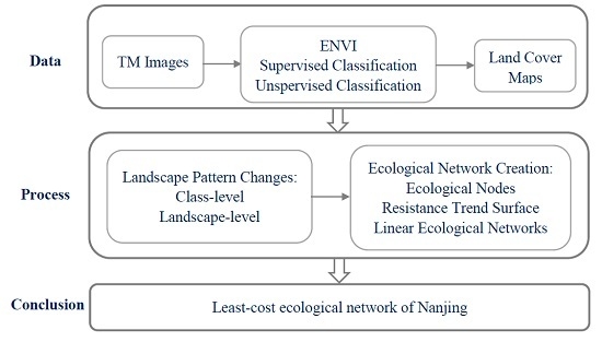
2. Study Area and Methods
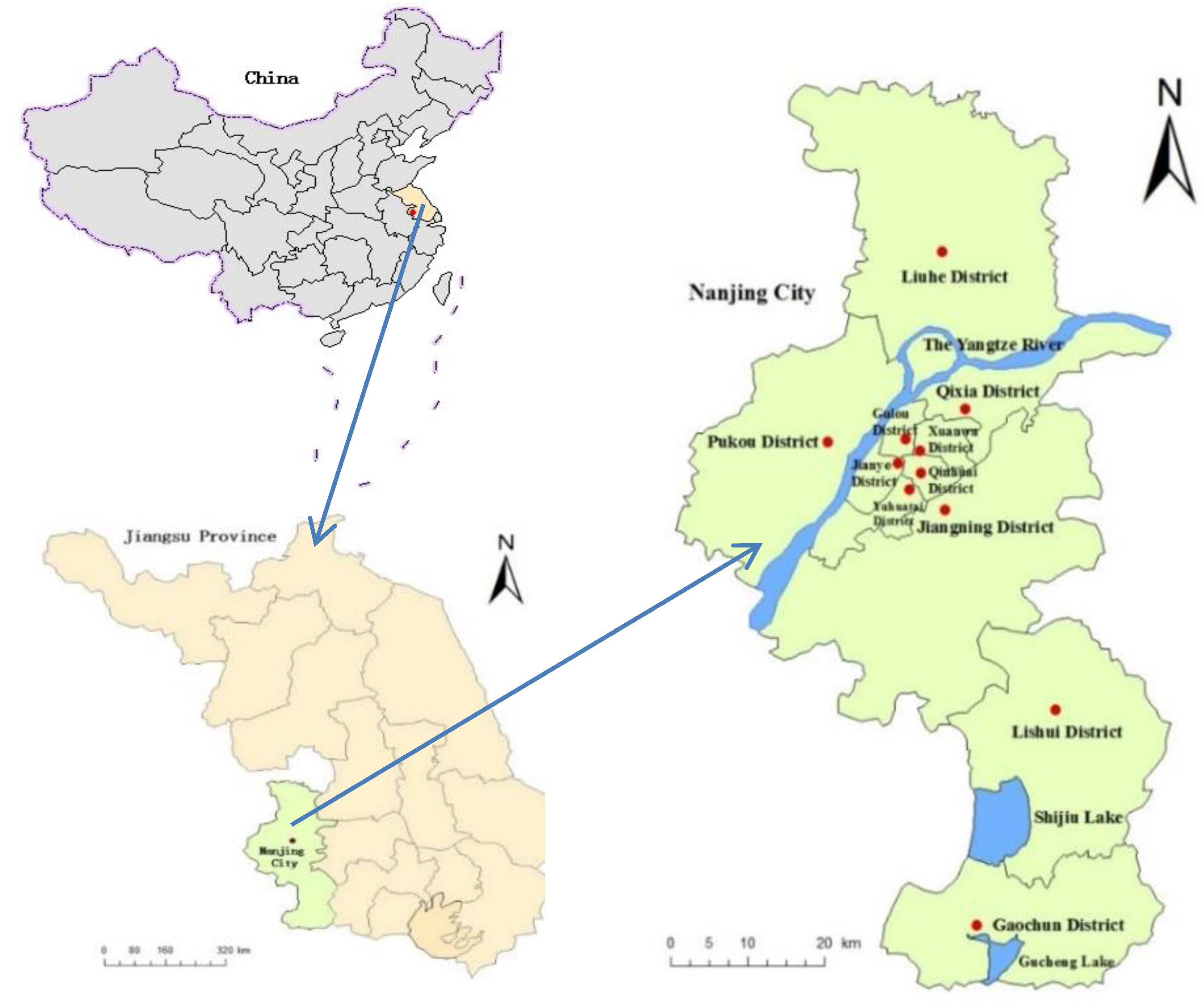
2.1. Study Area

2.2. Data Acquisition and Processing
2.3. Selection and Calculation of the Landscape Pattern Indexes


| Class-Level Indexes | Ecological Meaning | Calculation Equation |
|---|---|---|
| PLAND | Reflecting the situation of landscape grouping | (represents the area of patch ; A represents total area of the landscape) |
| AREA_MN | Reflecting the aggregation or fragmentation degree of the landscape patches | (A represents total area of the landscape; N represents the number of the whole patches) |
| PD | Reflecting the spatial heterogeneity of the landscape | (n represents the number of patches; A represents total area of the landscape) |
| LSI | Reflecting the variability of the landscape patches | (E represents the total length of all patch boundaries in the landscape; A represents total area of the landscape) |
| AI | Describing the agglomeration degree of different components in the landscape | (100) ( represents the number of adjacent patches in the corresponding landscape types) |
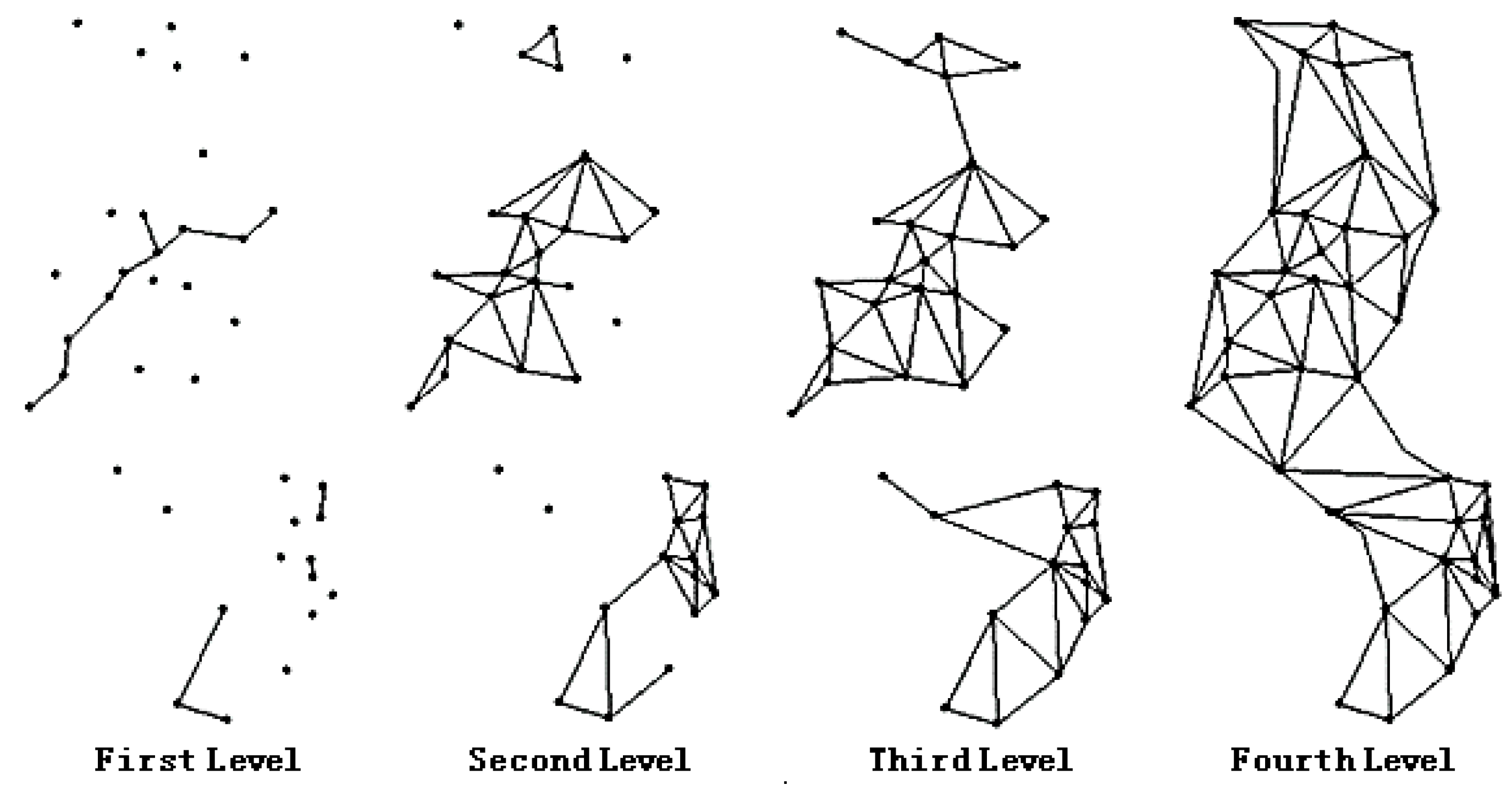
2.4. Construction of the Ecological Network
| Landscape-level Indexes | Ecological Meaning | Calculation Equation |
|---|---|---|
| SHDI | Investigating the diversity of the landscape pattern | ( represents the ratio that a certain type of patch accounts for in the whole landscape) |
| SHAPE_AM | Reflecting the complexity of the shape of the patches | ( represents the perimeter of the patch ij; represents the area of the patch ij) |
| FRAC-AM | Reflecting the complexity degree of the shape of average patches in the landscape | ( represents the perimeter of the patch ij; represents the area of the patch ij) |
| SI | Reflecting the complexity of the landscape space structure | ( represents the perimeter of the patch ij; represents the area of the patch ij) |
| SHEI | Reflecting the uneven distribution degree of area for each patch in the landscape | (represents the ratio that the area of patch k accounts for in the whole landscape; n represents the total number of patch types in the landscape) |
3. Results
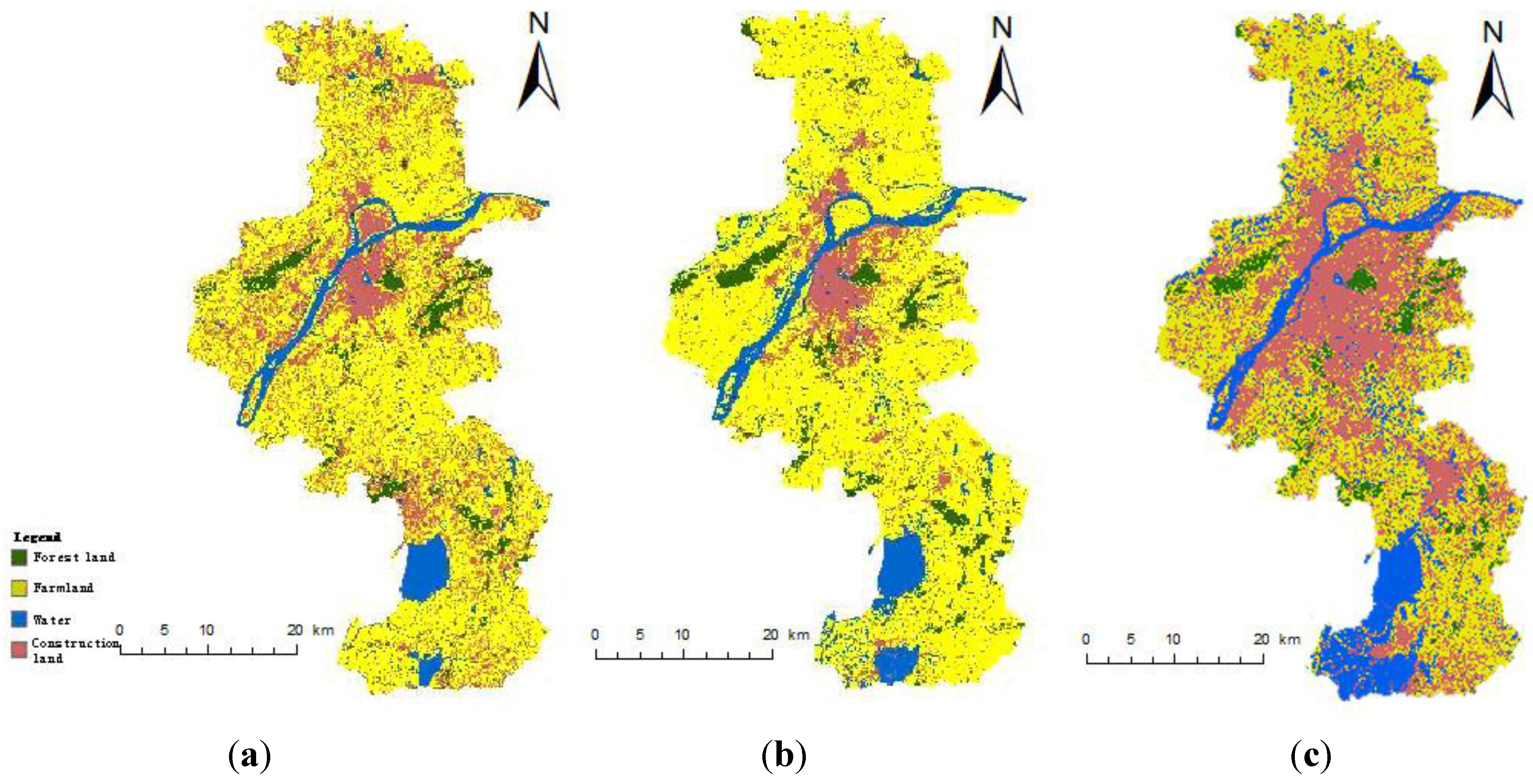
3.1. Analysis on the Characteristics of the Landscape Pattern Change
3.1.1. Class-Level
| Land Cover Types | Year | PLAND | AREA_MN | PD | LSI | AI |
|---|---|---|---|---|---|---|
| Farmland | 1990 | 67.19 | 263.01 | 0.25 | 82.62 | 92.51 |
| 2000 | 65.95 | 220.42 | 0.30 | 73.12 | 93.42 | |
| 2010 | 54.58 | 214.73 | 0.81 | 87.46 | 91.32 | |
| Water | 1990 | 11.63 | 19.56 | 0.91 | 66.75 | 79.57 |
| 2000 | 8.49 | 21.03 | 0.63 | 50.80 | 80.70 | |
| 2010 | 11.09 | 22.42 | 0.34 | 45.25 | 86.93 | |
| Forest | 1990 | 7.15 | 14.91 | 0.37 | 46.05 | 87.48 |
| 2000 | 8.49 | 15.32 | 0.40 | 50.94 | 87.27 | |
| 2010 | 8.69 | 16.55 | 0.90 | 66.19 | 83.56 | |
| Construction land | 1990 | 14.04 | 8.60 | 1.63 | 104.16 | 86.78 |
| 2000 | 15.93 | 10.29 | 1.55 | 104.76 | 88.09 | |
| 2010 | 25.65 | 20.38 | 0.90 | 90.27 | 90.13 |
3.1.2. Landscape-Level
| Year | SHDI | SHAPE_AM | FRAC_AM | SPLIT | SHEI |
|---|---|---|---|---|---|
| 1990 | 1.01 | 34.23 | 1.29 | 5.13 | 0.73 |
| 2000 | 1 | 27.80 | 1.28 | 5.99 | 0.72 |
| 2010 | 1.135 | 22.48 | 1.27 | 10.08 | 0.82 |
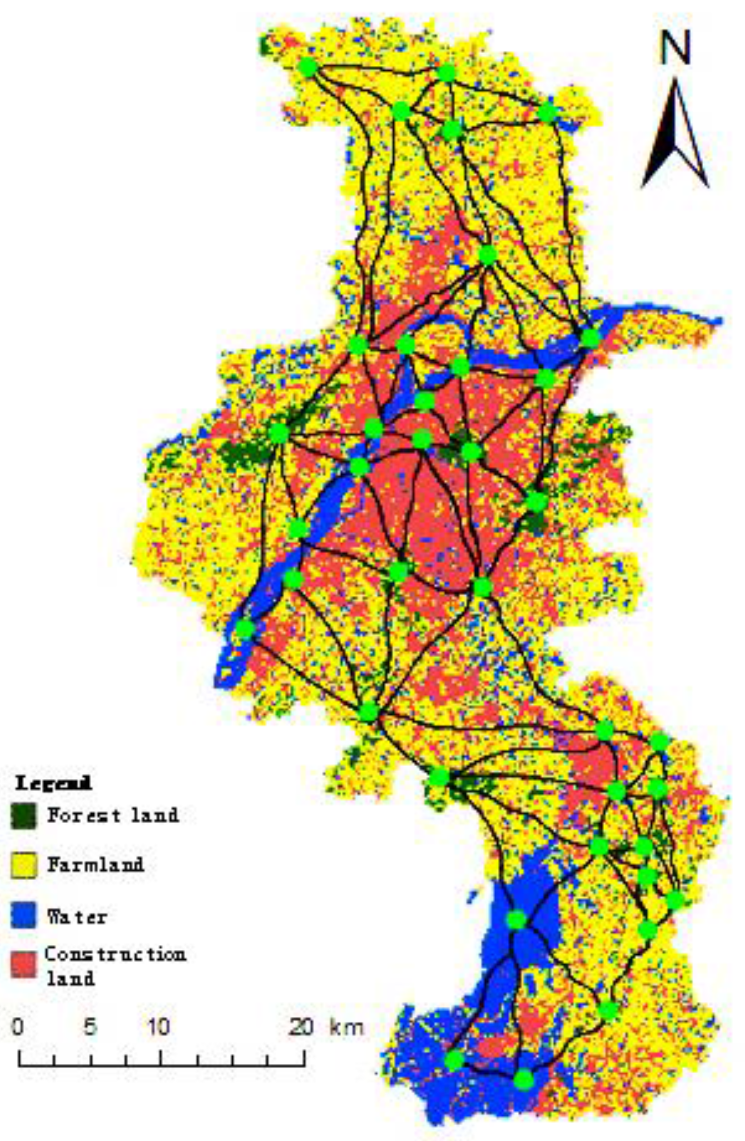
3.2. Creation of the Ecological Network
3.2.1. Extraction of Ecological Nodes
| Type | Name | Location | Function |
|---|---|---|---|
| Forest park | Purple Mountain Forest Park | Jiangning District | Biodiversity, natural and human landscape protection |
| Laoshan Forest Park | Pukou District | Biodiversity, natural and human landscape protection | |
| Fangshan Forest Park | Liuhe District | Water source conservation Natural and human landscape protection | |
| Pingshan Forest Park | Liuhe District | Natural and human landscape protection | |
| Wuxiang Temple Forest Park | Lishui District | Biodiversity, natural and human landscape protection | |
| Dajingshan Forest Park | Gaochun District | Water source and soil conservation | |
| Scenic area | Dragon Mountain Scenic Area | Pukou District | Natural and human landscape protection |
| Mufu Mountain Scenic Area | Xiaguan District | Natural and human landscape protection | |
| Lingyan Hill Scenic Area | Liuhe District | Geo-conservation Biodiversity protection | |
| Qixia MountainScenic Area | Qixia District | Biodiversity, natural and human landscape protection | |
| Niushou Mountain Forest Park | Yuhuatai District | Natural and human landscape protection | |
| Tang Hill National Geo-park | Jiangning District | Geological relic protection | |
| Nanshan Scenic Area | Jiangning District | Biodiversity, natural and human landscape protection | |
| Mao Mountain Residual Branch | Lishui District Gaochun District | Biodiversity protection Water source conservation | |
| Youzi Mountain Scenic Area | Gaochun District | Biodiversity, natural and human landscape protection | |
| Wetland | Qiqiaoweng Wetland Park | Qinhuai District | Wetland ecosystem maintenance |
| Xuanwu Lake Wetland Park | Xuanwu District | Wetland ecosystem maintenance | |
| Gucheng Lake Natural Reserve | Gaochun District | Water and aquatic resources | |
| Shijiu Lake | Lishui District Gaochun District | Natural and human landscape protection | |
| Wetland by Yangtze river | Xinsheng island, Xinji island, Zaisheng island | Wetland ecosystem maintenance | |
| Shanhu Reservoir | Liuhe District | Irrigated agriculture | |
| Daquan Reservoir | Liuhe District | Irrigated agriculture | |
| Zheshantou Reservoir | Jingqiao Town | Irrigated agriculture | |
| Yaojia Reservoir | Jingqiao Town | Irrigated agriculture | |
| Wolong Mountain Reservoir | Lishui District | Irrigated agriculture | |
| Zhongshan Reservoir | Lishui District | Irrigated agriculture Water source and water quality protection | |
| Fangbian Reservoir | Lishui District | Irrigated agriculture Water source and water quality protection | |
| Hewangba Reservoir | Liuhe District | Irrigated agriculture | |
| Zhaocun Reservoir | Jiangning District | Irrigated agriculture | |
| Yanziji Water Source | Northcity water plant | Water source and water quality | |
| Baguazhou Water Source | Yuangu water plant | Water source and water quality | |
| Jiangpu & Pukou Water Source | Jiangpu water plant | Water source and water quality | |
| Baguazhou Spare Water Source | Jiangning District | Water source and water quality | |
| Jiajiang Water Source | Jiangning District | Water source and water quality |
3.2.2. Ecological Network Construction

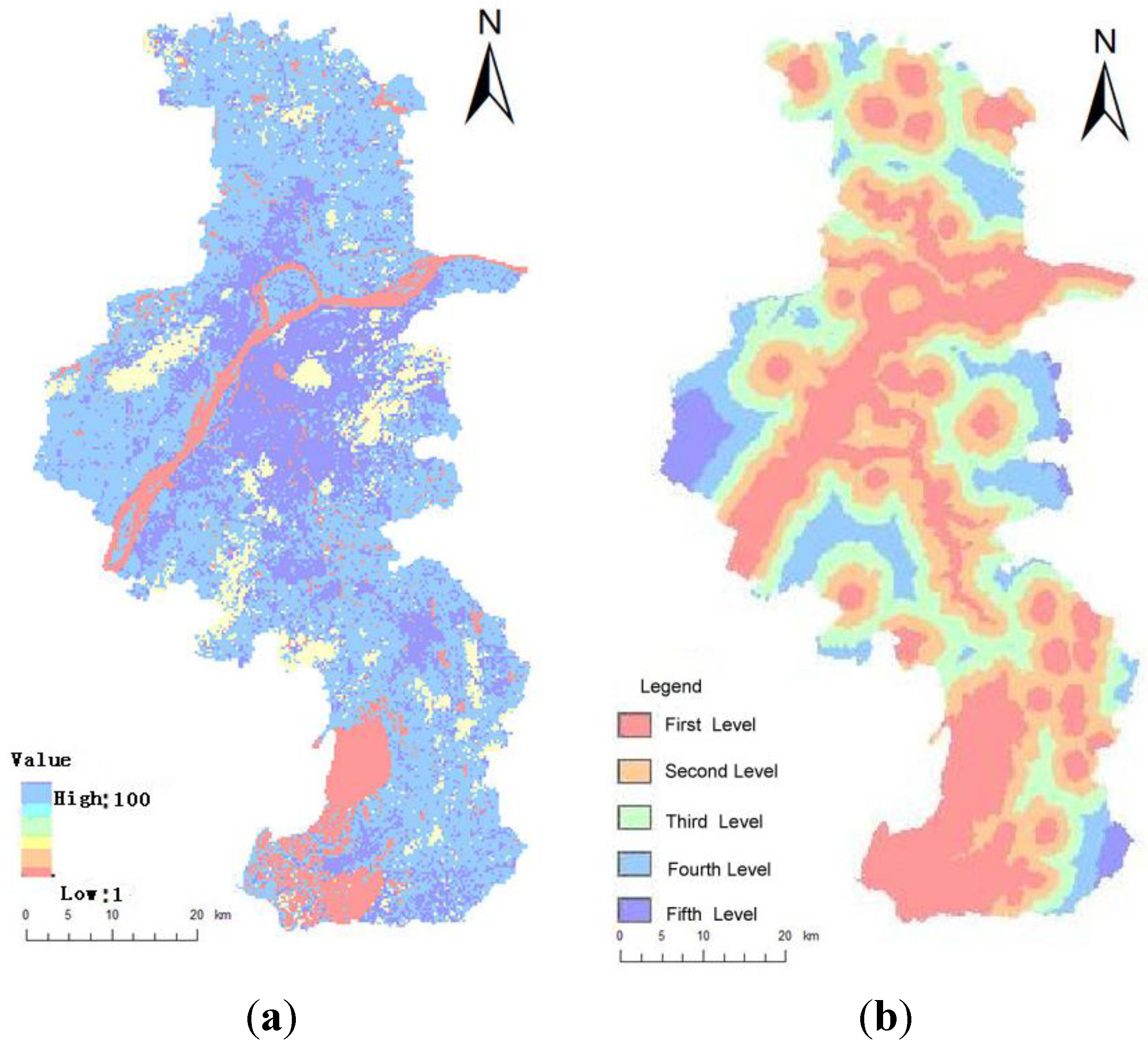


4. Conclusions
Acknowledgments
Author Contributions
Conflicts of Interest
References
- Fu, B.J. Theory and Application of Landscape Ecology; Science Press: Beijing, China, 2001. [Google Scholar]
- Forman, R.T.T.; Godron, M. Landscape Ecology; John Wiley and Sons: New York, NY, USA, 1986. [Google Scholar]
- Chen, L.D.; Sun, R.H.; Liu, H.L. Eco-environmental effects of urban landscape pattern changes: Progresses, problems and perspectives. Acta Ecol. Sin. 2013, 33, 1042–1050. [Google Scholar] [CrossRef]
- Guo, L.; Du, S.H.; Xue, D.Y. Spatio-temporal variation of landscape patterns during rapid urbanization in Guangzhou city. Acta Sci. Nat. Univ. Pekin. 2009, 45, 129–135. [Google Scholar]
- Xu, J.X.; Li, G.; Qu, J.F. Changes of land use and landscape pattern in Hongze Lake basin. Resour. Environ. Yangtze Basin 2011, 20, 1214–1215. [Google Scholar]
- Chen, X.L.; Chen, S.J.; Du, P.J. A study of the landscape pattern change of Longyan City based on multi-temporal remote sensing images. Remote Sens. L. Res. 2012, 2, 135–136. [Google Scholar]
- Sun, F.Y.; Liu, M.; Hu, Y.M. A comprehensive analysis of landscape pattern dynamic change based on multi-methods: A case study of Tieling city, Liaoning province of northeast China. Chin. J. Ecol. 2013, 32, 2167–2168. [Google Scholar]
- Yu, Q.Z.; Zhang, Z.L.; Gao, B. Study on the changes of landscape pattern in Nansihu wetland based on RS and frags tats. Forest Res. Manag. 2013, 1, 111–112. [Google Scholar]
- Chen, A.L.; Sun, R.H.; Chen, L.D. Applicability of traditional landscape metrics in evaluating urban heat island effect. Chin. J. Appl. Ecol. 2012, 23, 2077–2086. [Google Scholar]
- Liu, X.P.; Li, X.; Chen, Y.M.; Qin, Y.; Li, S.Y.; Chen, M.H. Landscape expansion index and its applications to quantitative analysis of urban expansion. Acta Geogr. Sin. 2009, 64, 1430–1438. [Google Scholar]
- Huang, S.Q.; Chen, Y.; Zhang, R.Z.; Wu, W.; Wei, C. Spatial correlation analysis of land fragmentation and agriculture development based on landscape indexes. Agr. Res. Arid Area. 2015, 33, 238–244. [Google Scholar]
- Wu, N.T.; Yue, D.P.; Zhang, Y.C.; Cao, R.; Shang, S. Identification and analysis of ecological nodes of urban and suburban areas based on 3S technology. Environ. Sci. Tech. 2014, 37, 184–189. [Google Scholar]
- Liu, J.; Pu, W.R. Planning and Design of City Greenland System; Chinese Construction Industry Press: Beijing, China, 2004. [Google Scholar]
- Fu, B.J.; Chen, L.D.; Ma, K.P.; Wang, Y.L. Principle and Application of Landscape Ecology; Science Press: Beijing, China, 2001. [Google Scholar]
- Jongman, R.H.G. Nature conservation planning in Europe: Developing ecological networks. Landsc. Urban Plan. 1995, 32, 169–183. [Google Scholar] [CrossRef]
- Jongman, R.H.G.; Pungetti, G. Ecological Networks and Greenways: Concept, Design, Implementation; Cambridge University Press: Cambridge, UK, 2004. [Google Scholar]
- Liu, B.Y.; Wang, P. Green ecological network planning development and China research frontier. Chin. Gard. 2010, 26, 1–5. [Google Scholar]
- Liu, B.Y.; Yu, C. Greenway networks planning of USA and its apocalypse to us. Chin. Gard. 2001, 6, 77–81. [Google Scholar]
- Government of Toronto, Canada. Urban Planning and Development Services of Toronto, Canada. Garrison Creek Linkage Plan; 1998; (Unpublished work). [Google Scholar]
- Huang, Y.; Chen, H.; Huang, Z.J. Construction of urban green space ecosystem by using corridor networks: A case study in west urban area of Dongying city, Shandong province. Chin. J. Appl. Ecol. 2006, 17, 1683–1687. [Google Scholar]
- Kong, F.H.; Yin, H.W. Developing green space ecological networks in Jinan city. Acta Ecol. Sin. 2008, 28, 1712–1718. [Google Scholar]
- Adriaensen, F.; Chardon, J.P.; Blust, G.D. The application of “least-cost” modeling as a functional landscape model. Landsc. Urban Plan. 2003, 64, 233–247. [Google Scholar] [CrossRef]
- Zhang, X.F.; Wang, Y.L.; Li, G.C. Landscape functions network construction and application in watershed scale: A case study on Taiwan Wuxi watershed. Acta Geogr. Sin. 2005, 60, 974–980. [Google Scholar]
- Liu, J.; Yang, W. A GIS-based landscape pattern optimization approach for Lake Dianchi watershed. J. Nat. Resour. 2012, 27, 802–805. [Google Scholar]
- Li, J.H.; Liu, X.H. Research of the nature reserve zonation based on the least-cost distance model. J. Nat. Resour. 2006, 21, 217–224. [Google Scholar]
- Guo, H.B.; Huang, Y.X.; Ye, G.F. A study on the evaluation and optimization of urban ecological function network in Xiamen. J. Nat. Resour. 2010, 25, 75–76. [Google Scholar]
- Liu, C.L. Landscape Ecology Spatial Pattern Change and Optimization Measures in Nanjing. Master’s Thesis, Nanjing Agricultural University, Nanjing, China, 2006. [Google Scholar]
- Liu, J.J.; Li, J.D.; Liu, H. GIS-based ecological corridor of Shenyang landscape. J. Shenyang Agr. Univ. 2012, 43, 279–283. [Google Scholar]
- Wang, Y.C.; Liu, Y.L. Researches on spatial model application of urban landscape eco-network planning. Resour. Environ. Yangtze Basin 2009, 18, 819–824. [Google Scholar]
- Yang, Z.F.; He, M.C. Urban Ecological Sustainable Development Planning; Science Press: Beijing, China, 2004. [Google Scholar]
- Wang, H.Z.; Zhang, L.Q. A GIS, landscape pattern and network analysis based planning of ecological networks for Xiamen Island. Acta Phytoecol. Sin. 2005, 29, 144–152. [Google Scholar]
- General Administration of Quality Supervision, Inspection and Quarantine of the PRC, Standardization Administration of the PRC. Classification of Land Use Present Situation; Chinese Standardization Press: Beijing, China, 2007.
- Yang, Z.H. Landscape pattern analysis of Hainan natural meadow in China based on Fragstats and thematic mapper. J. Landsc. Res. 2012, 4, 13–14. [Google Scholar]
- Zheng, X.Q.; Fu, M.C. Spatial Analysis Techniques and Application of Landscape Pattern; Science Press: Beijing, China, 2010. [Google Scholar]
- McGarigal, K.; Marks, B. FRAGSTATS: Spatial Pattern Analysis Program for Quantifying Landscape Structure; Oregon State University: Corvallis, OR, USA, 1994. [Google Scholar]
- Chen, W.B.; Xiao, D.N.; Li, X.Z. Classification, application and creation of landscape indices. Chin. J. Appl. Ecol. 2002, 13, 121–125. [Google Scholar]
- Parcerisas, L.; Marull, J.; Pino, J.; Tello, E.; Coll, F.; Basnou, C. Land use changes, landscape ecology and their socioeconomic driving forces in the Spanish Mediterranean coast (El Maresme County, 1850–2005). J. Environ. Sci. Policy 2012, 23, 120–132. [Google Scholar] [CrossRef]
- Bhatt, G.D.; Kushwaha, S.P.S.; Nandy, S.; Bargali, K.; Nagar, P.S.; Tadvi, D.M. Analysis of fragmentation and disturbance regimes in South Gujarat forests, India. Trop. Ecol. 2015, 56, 275–288. [Google Scholar]
- Girvetz, E.H.; Thorne, J.H.; Berry, A.M.; Jaeger, J.A.G. Integration of landscape fragmentation analysis into regional planning: A statement multi-scale case study from California, USA. Landsc. Urban. Plan. 2008, 86, 205–218. [Google Scholar] [CrossRef]
- Fahrig, L. Effects of habitat fragmentation on biodiversity. Annu. Rev. Ecol. Evol. Syst. 2003, 34, 487–515. [Google Scholar] [CrossRef]
- Chen, L.D.; Fu, B.J.; Zhao, W.W. Source-sink landscape theory and its ecological significance. Acta Ecol. Sin. 2006, 26, 1444–1449. [Google Scholar] [CrossRef]
- People’s Government of Jiangsu Province. Protection Planning of Ecological Red-Line Areas of Jiangsu Province. Available online: http://www.jiangsu.gov.cn/jsgov/tj/bgt/201309/t20130923_400467.html (accessed on 30 August 2013).
- Jiao, S.; Li, Z.M.; Gao, Q.; Zhou, K.; Wei, C.Y.; He, S.Y. The application of landscape connectivity theory in urban ecology suitability assessment and optimization. Geogr. Res. 2013, 32, 720–730. [Google Scholar]
- Ying, F.N.; Wang, X.L. Ecological landscape planning of the Four-Lake Basin based on accumulative minimum resistance model. J. Huazhong Agr. Univ. 2010, 29, 231–235. [Google Scholar]
- Liu, X.F.; Shu, J.M.; Zhang, L.B. Research on applying minimal cumulative resistance model in urban land ecological suitability assessment: As an example of Xianmen City. Acta Ecol. Sin. 2010, 30, 421–428. [Google Scholar]
© 2015 by the authors; licensee MDPI, Basel, Switzerland. This article is an open access article distributed under the terms and conditions of the Creative Commons Attribution license (http://creativecommons.org/licenses/by/4.0/).
Share and Cite
Dong, J.; Dai, W.; Shao, G.; Xu, J. Ecological Network Construction Based on Minimum Cumulative Resistance for the City of Nanjing, China. ISPRS Int. J. Geo-Inf. 2015, 4, 2045-2060. https://doi.org/10.3390/ijgi4042045
Dong J, Dai W, Shao G, Xu J. Ecological Network Construction Based on Minimum Cumulative Resistance for the City of Nanjing, China. ISPRS International Journal of Geo-Information. 2015; 4(4):2045-2060. https://doi.org/10.3390/ijgi4042045
Chicago/Turabian StyleDong, Jihong, Wenting Dai, Guoquan Shao, and Jiren Xu. 2015. "Ecological Network Construction Based on Minimum Cumulative Resistance for the City of Nanjing, China" ISPRS International Journal of Geo-Information 4, no. 4: 2045-2060. https://doi.org/10.3390/ijgi4042045