Geo-Spatial Support for Assessment of Anthropic Impact on Biodiversity


 ,
, 
Abstract
:
1. Introduction


2. Methodology
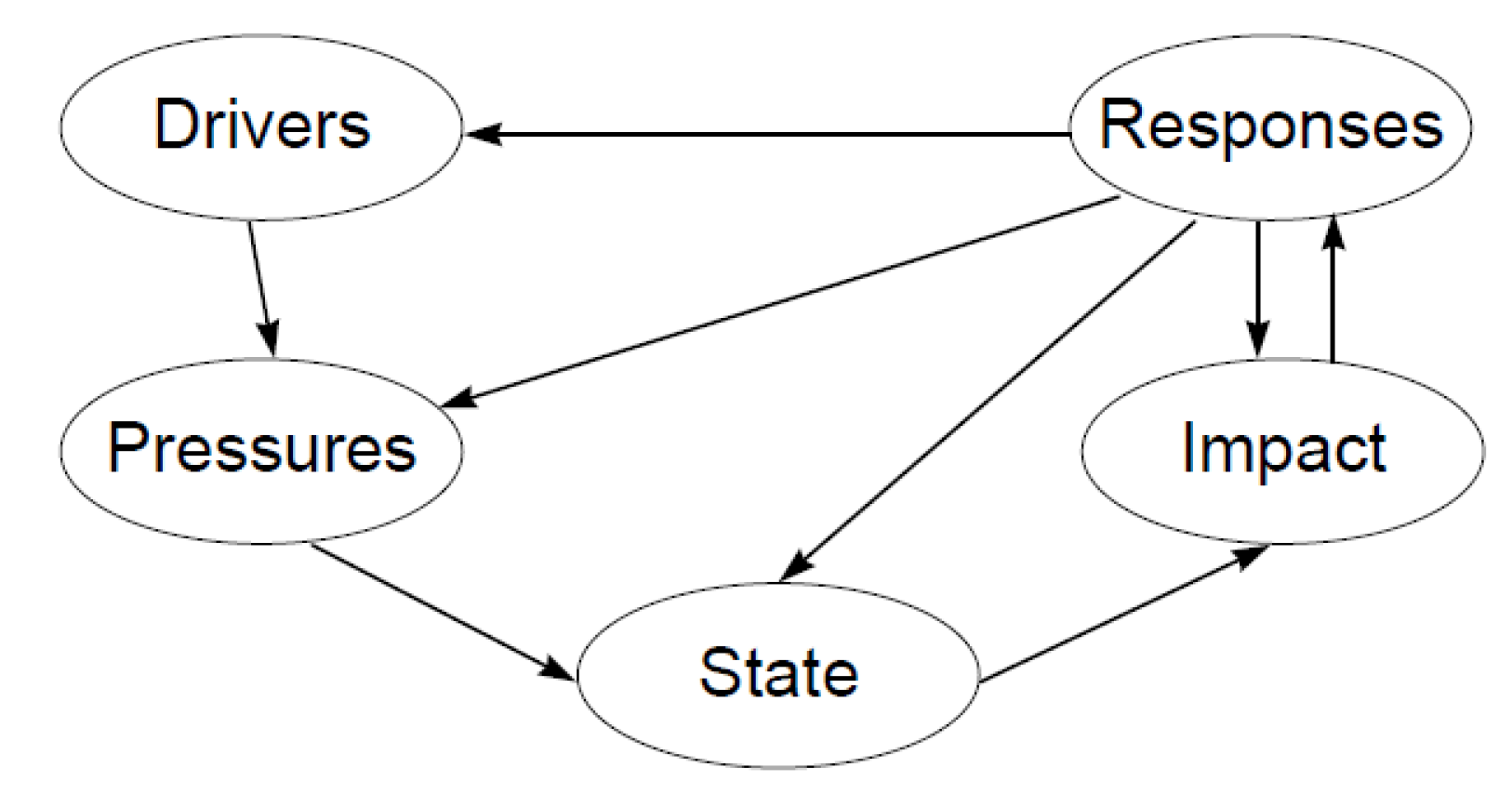
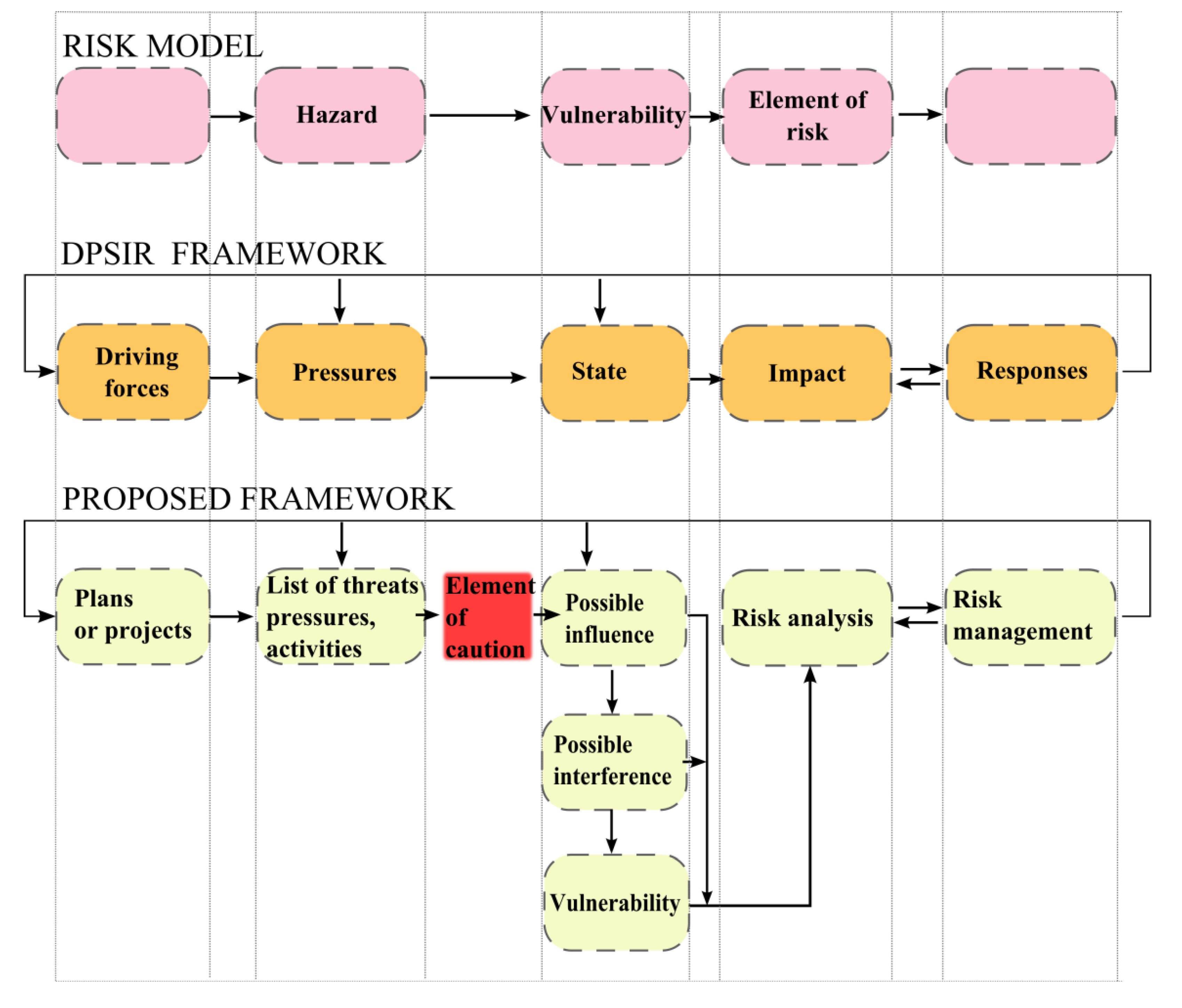
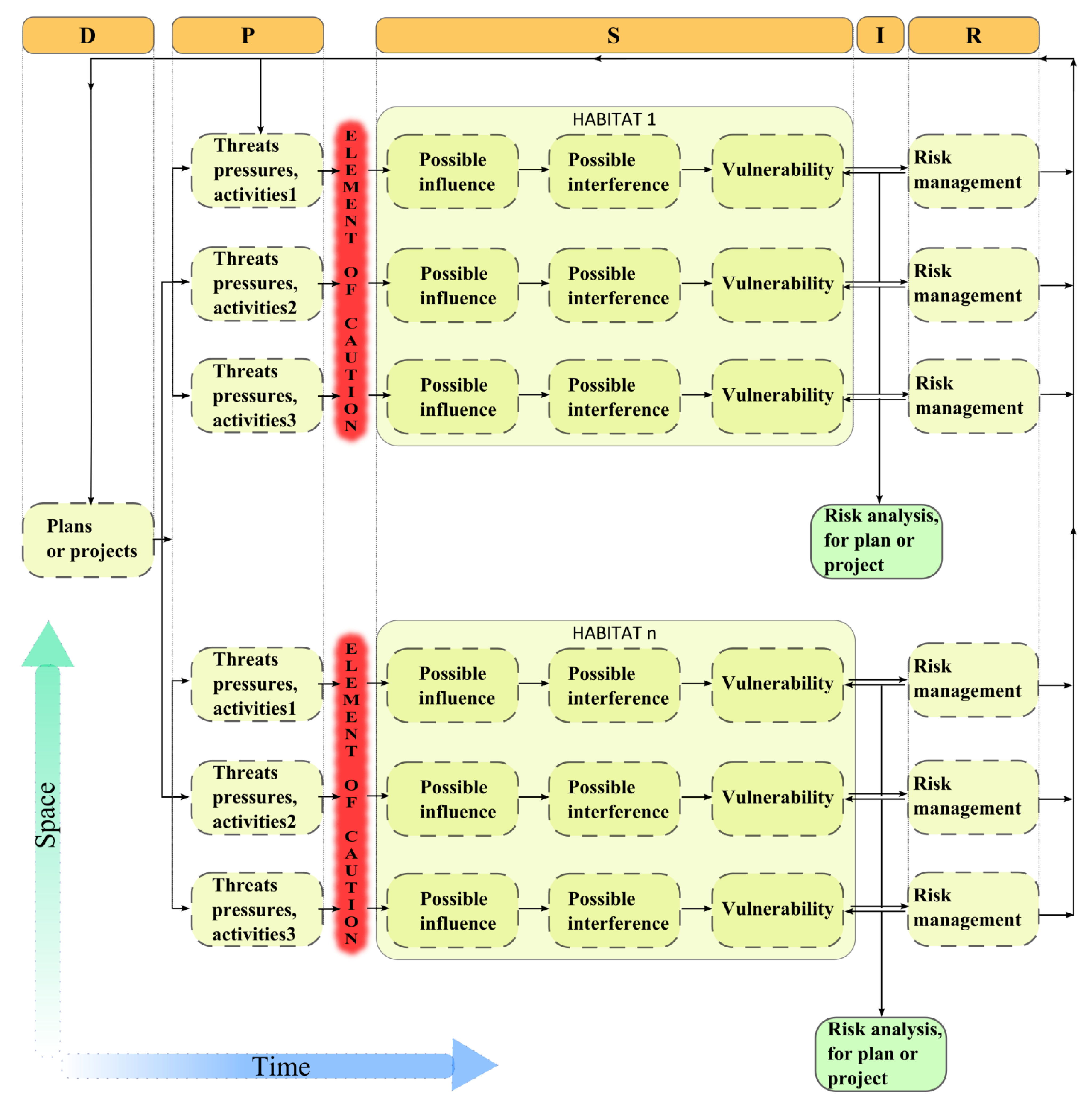
2.1. Definition of Anthropic Risk Assessment on Biodiversity

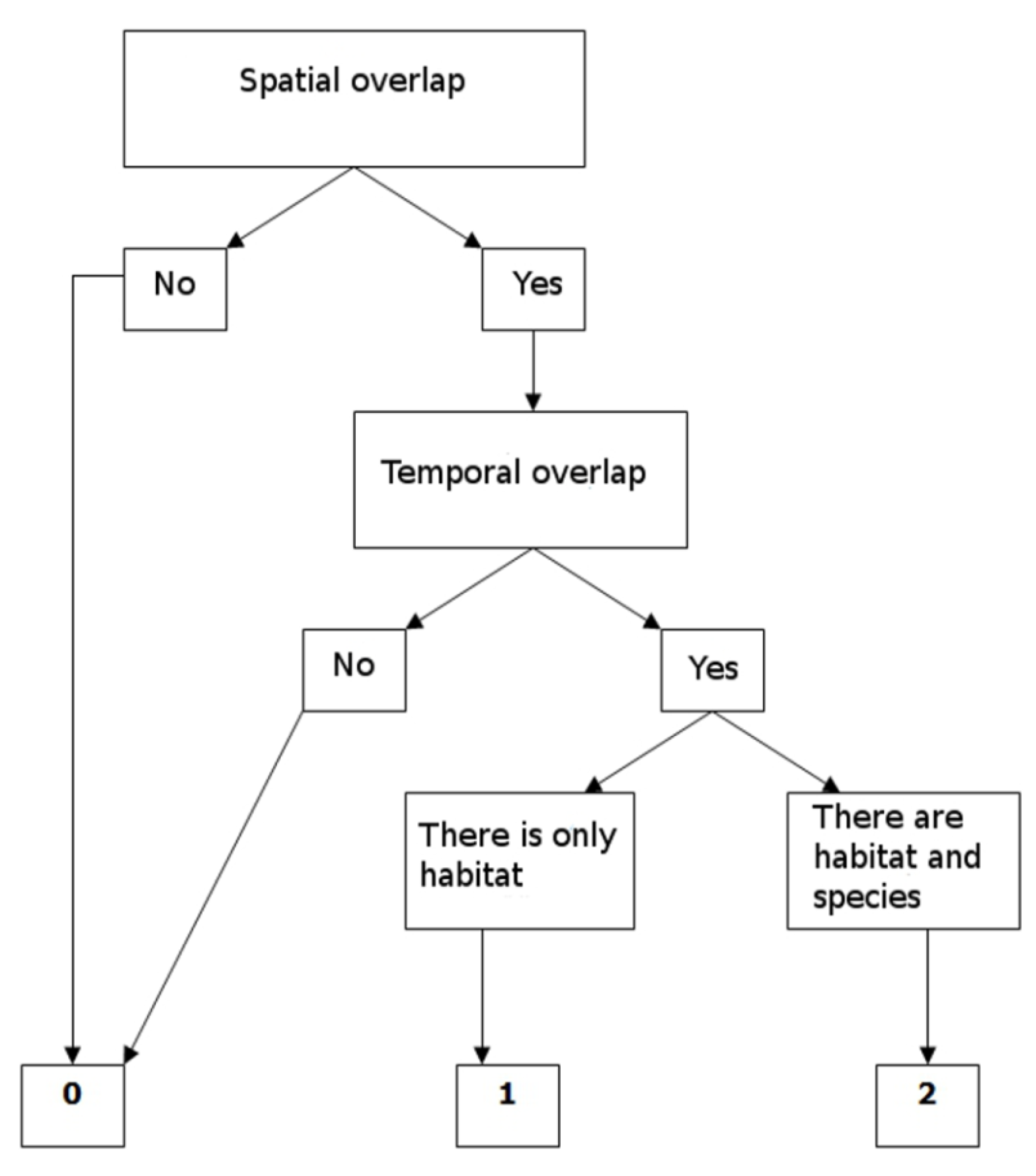
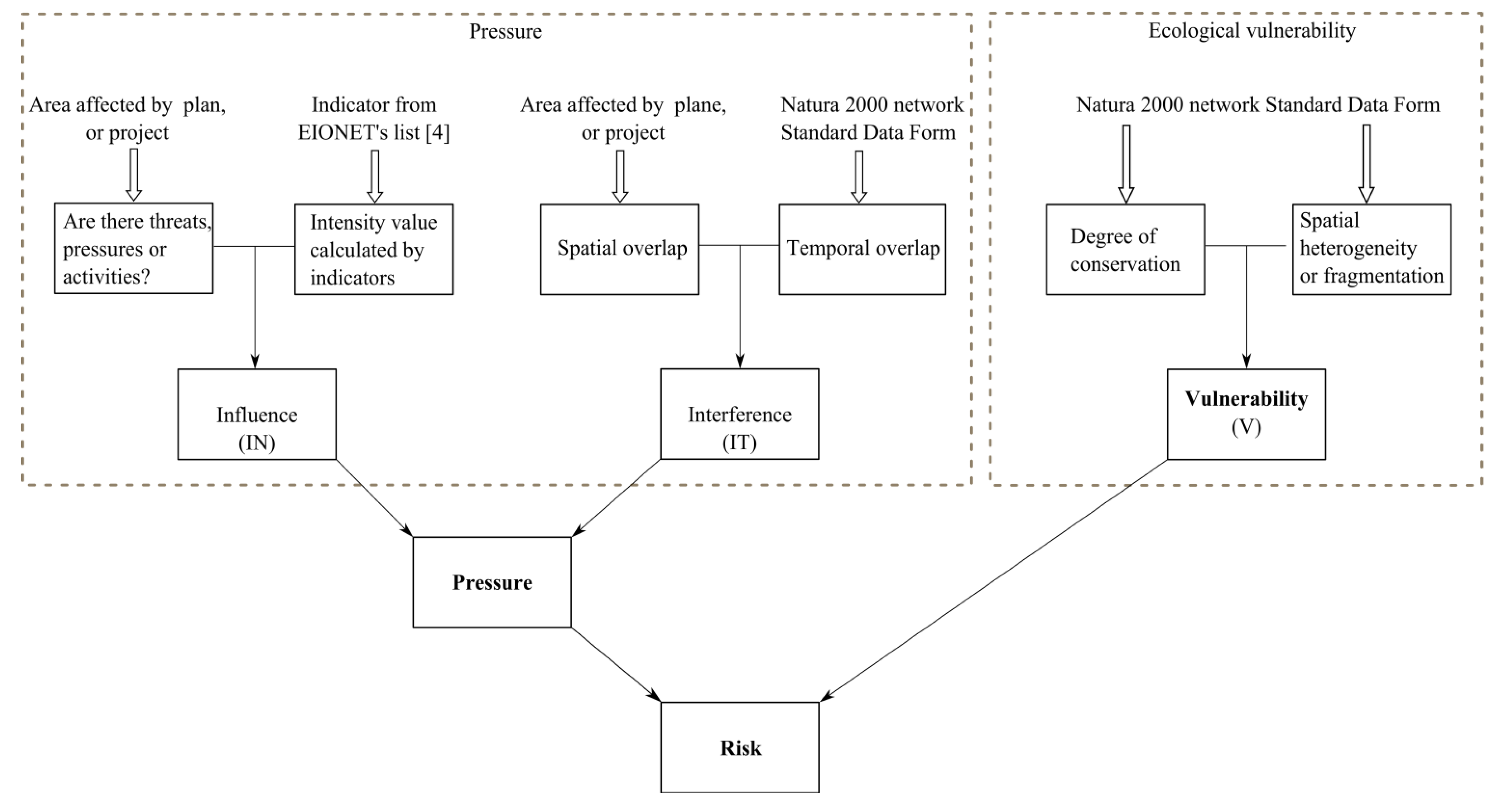
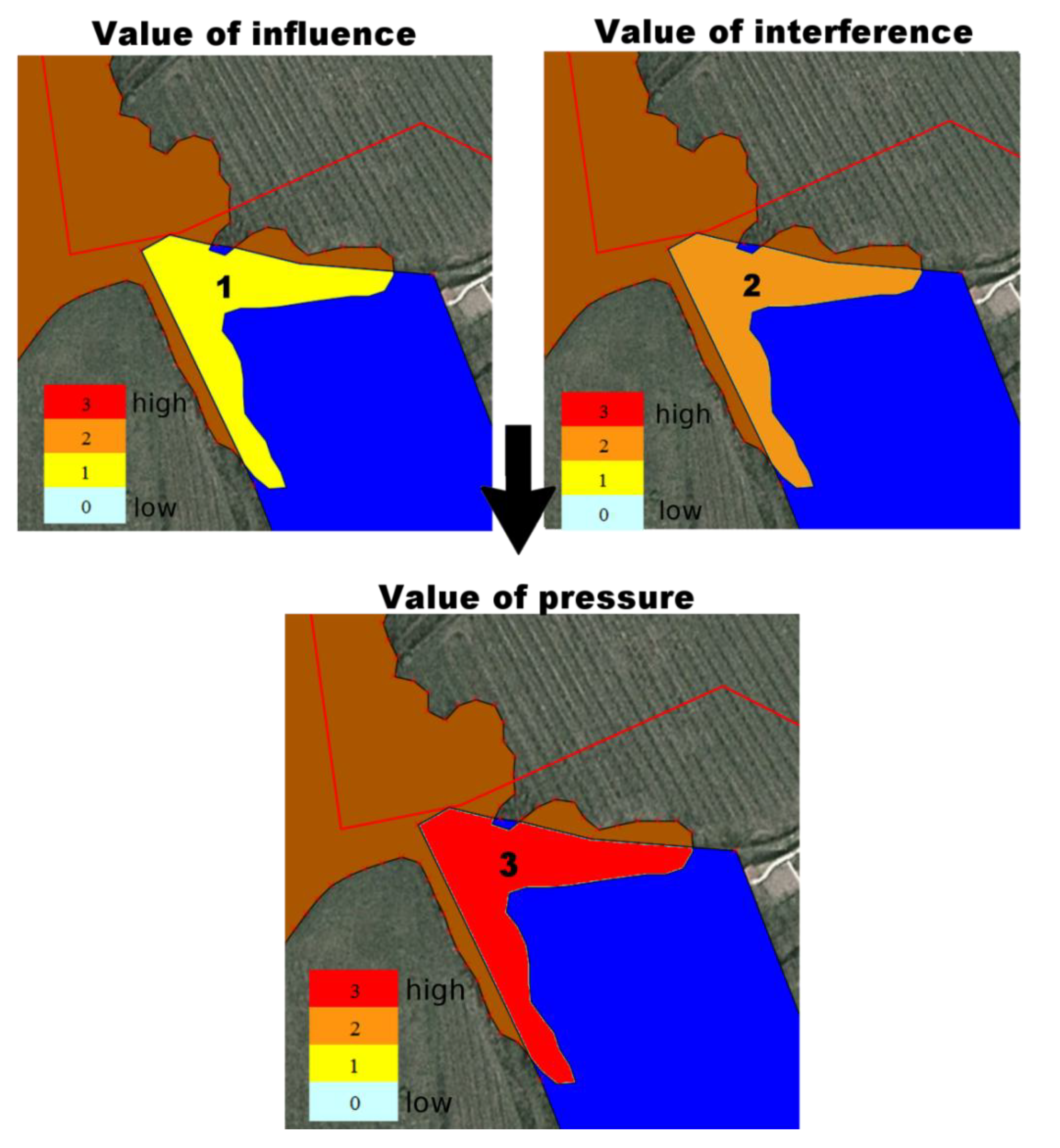
2.2. Assessment of the Influence
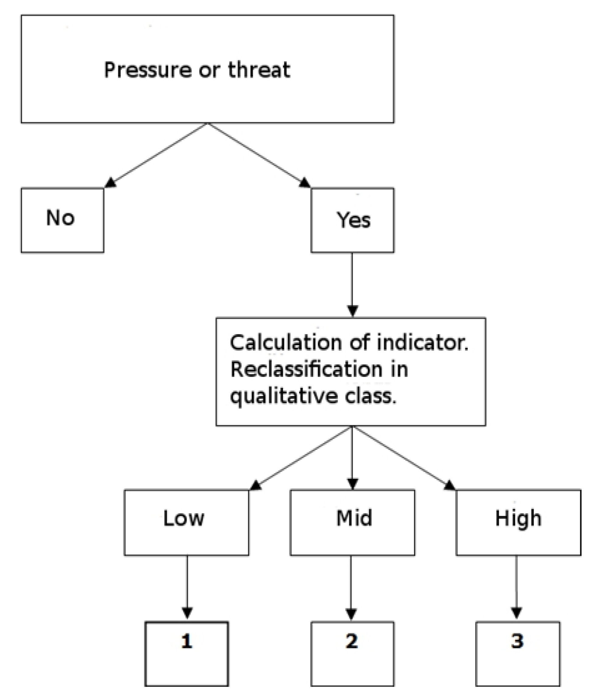
2.3. Check Temporal Interference (Elements of Risk)
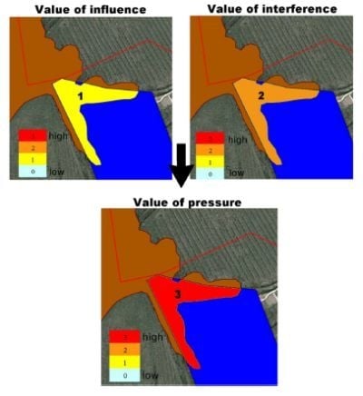
2.4. Pressure Assessment

| Influence | ||||
|---|---|---|---|---|
| 1 | 2 | 3 | ||
| Interference | 0 | 0 | 0 | 0 |
| 1 | 1 | 2 | 3 | |
| 2 | 3 | 3 | 3 | |
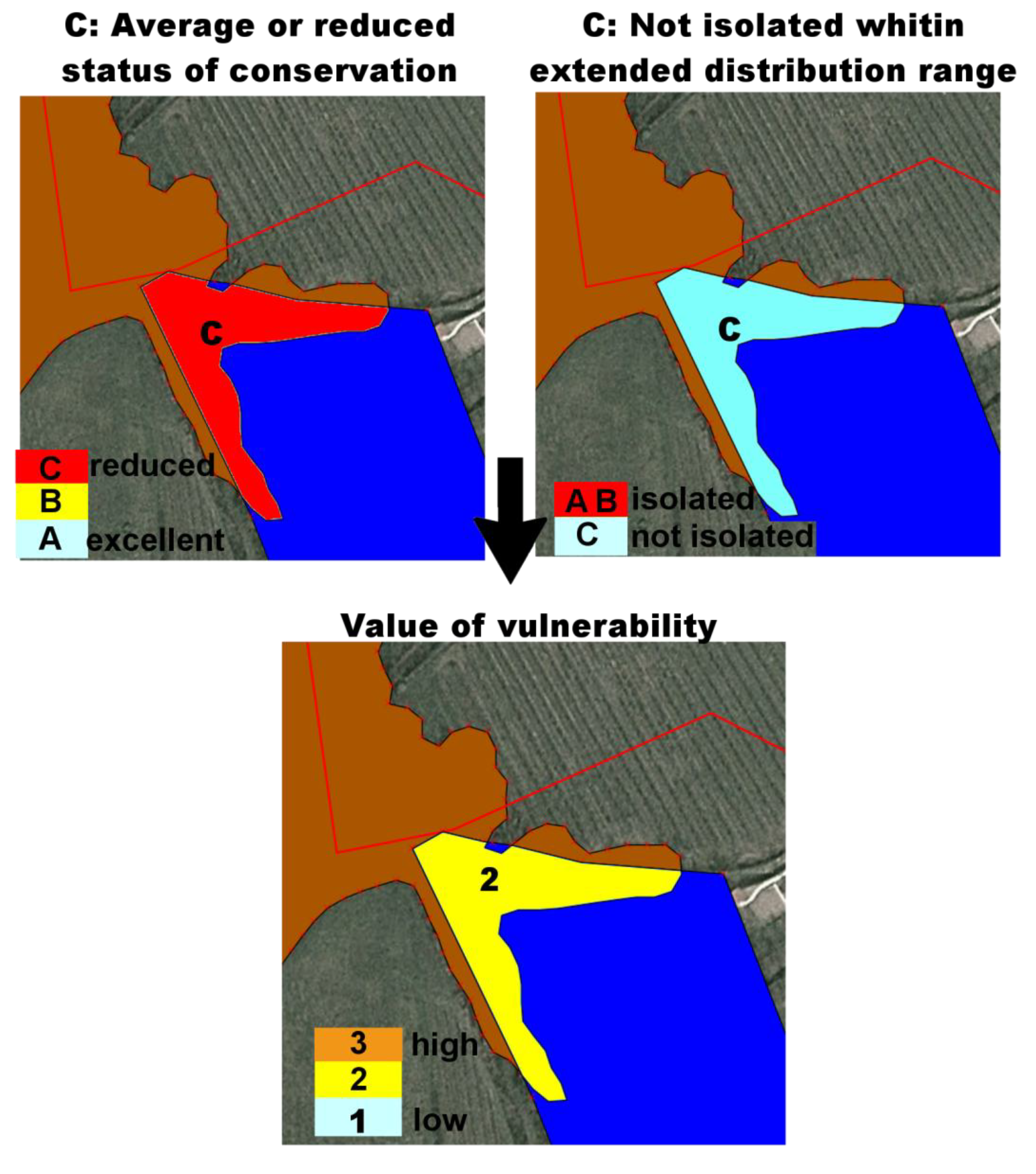
2.5. Assessment of Vulnerability
3. Results
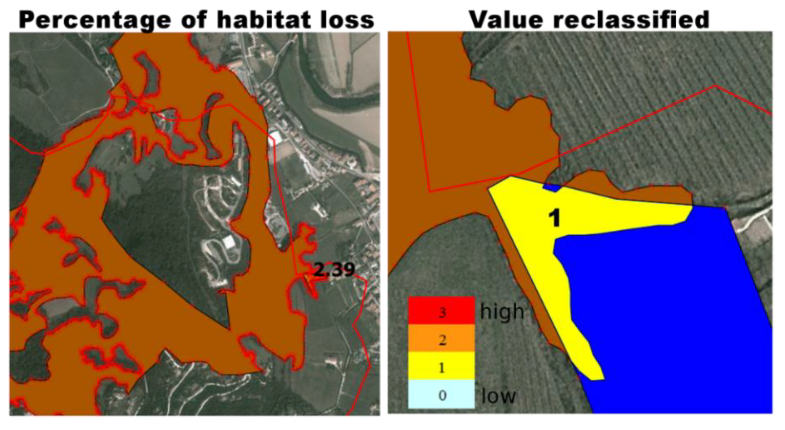
3.1. Simulation of Pressure and Land-cover Change
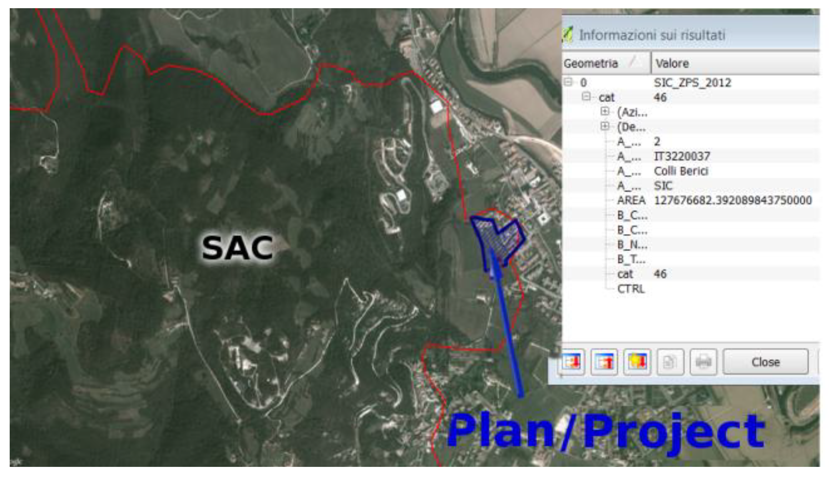
3.2. Verify if Risk Assessment is Necessary

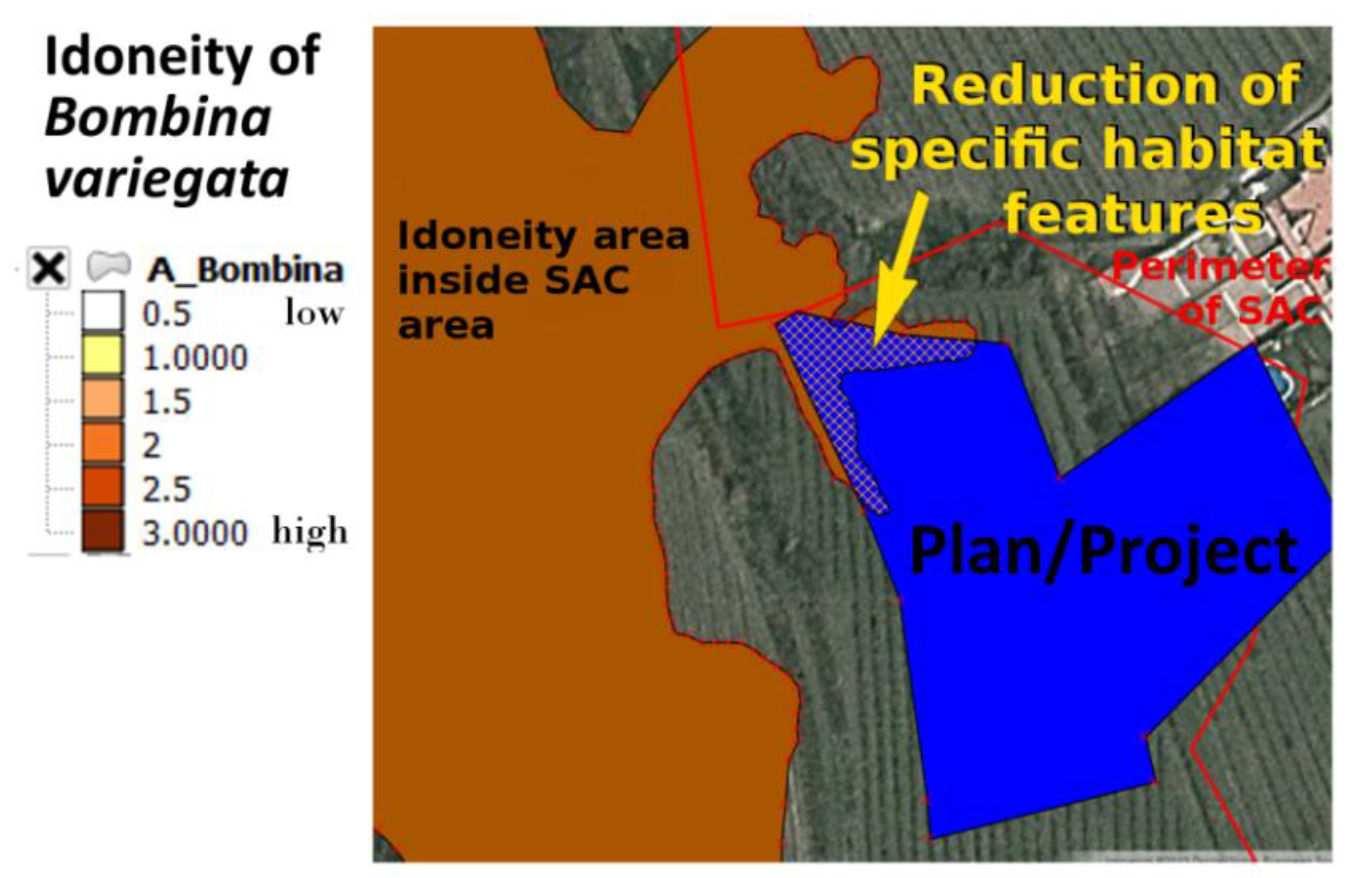
3.3. Identification of Threats, Pressures and Activities
| Code | Description |
|---|---|
| J.03.01 | Reduction or loss of specific habitat features |

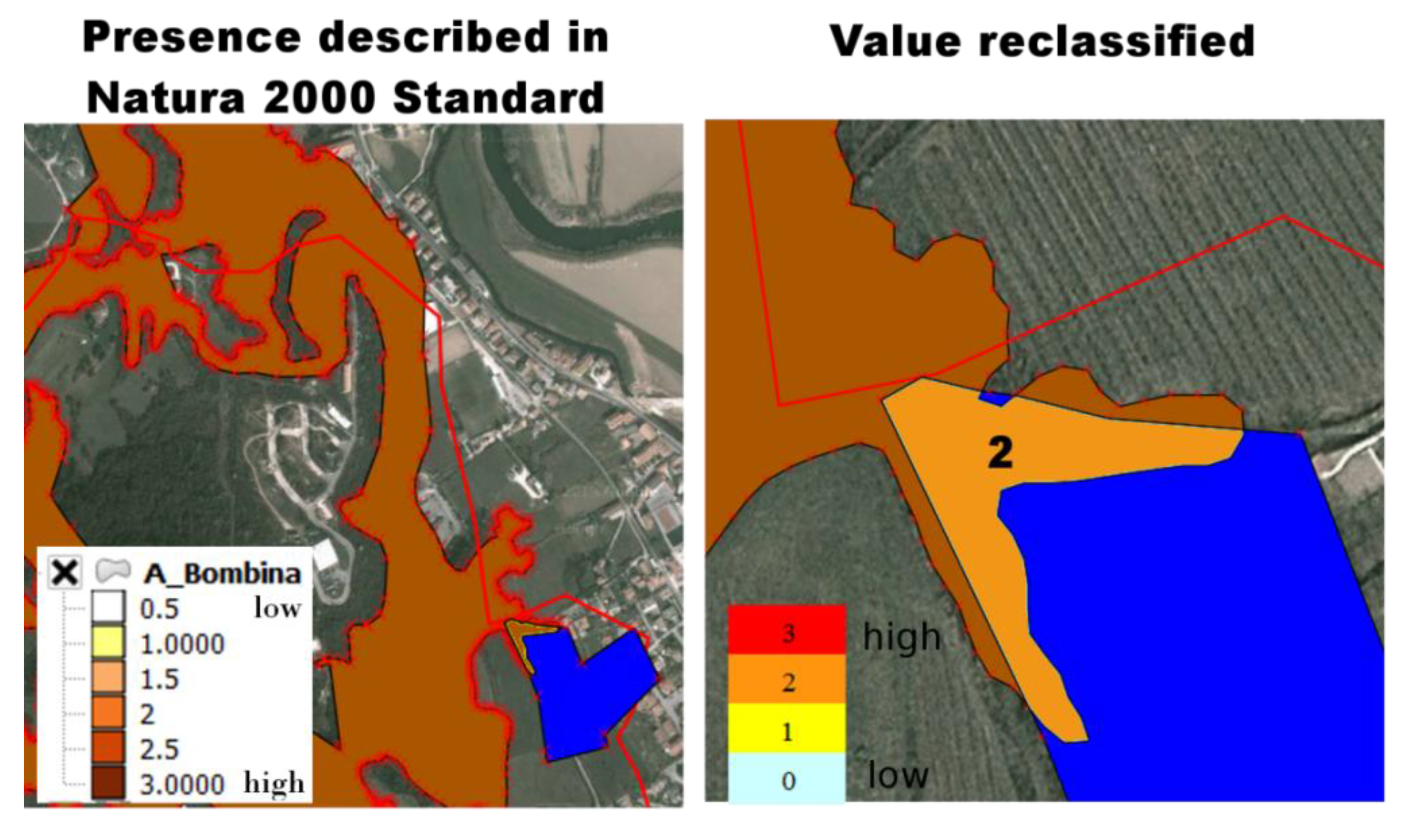
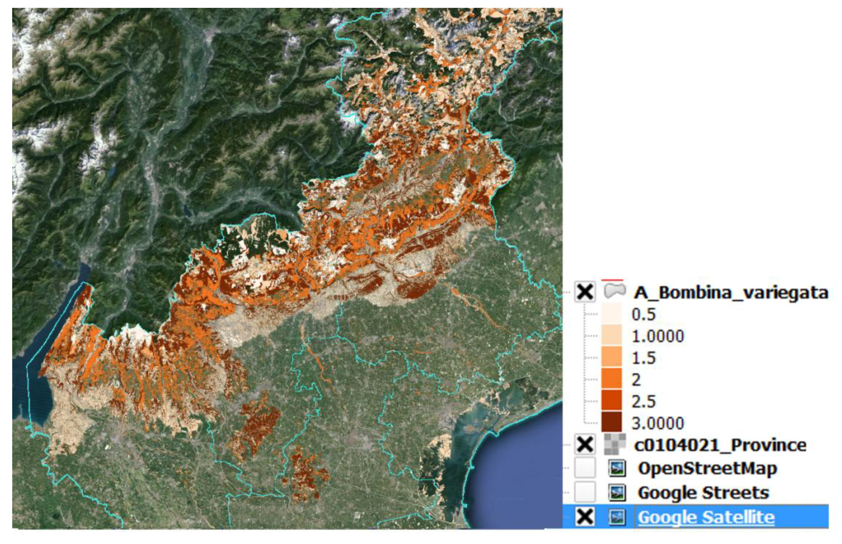
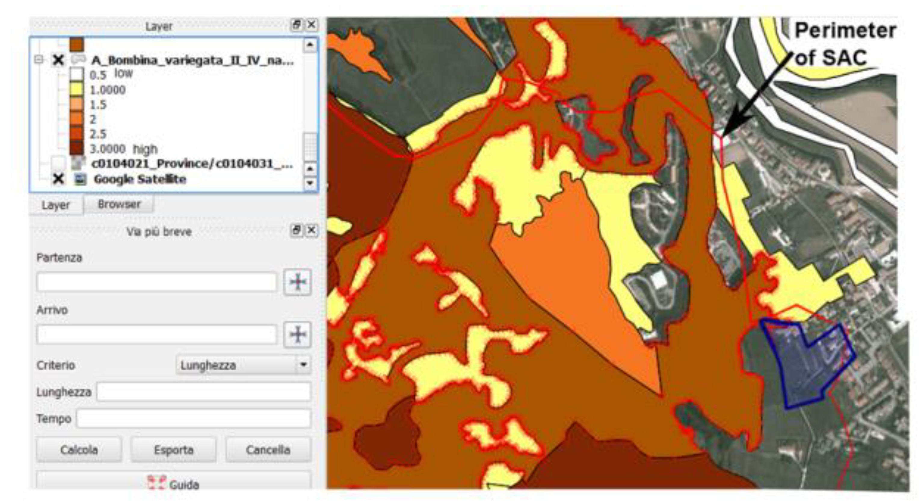
3.4. Calculation of the Influence

3.5. Calculation of the Interference
3.6. Calculation of the Pressure

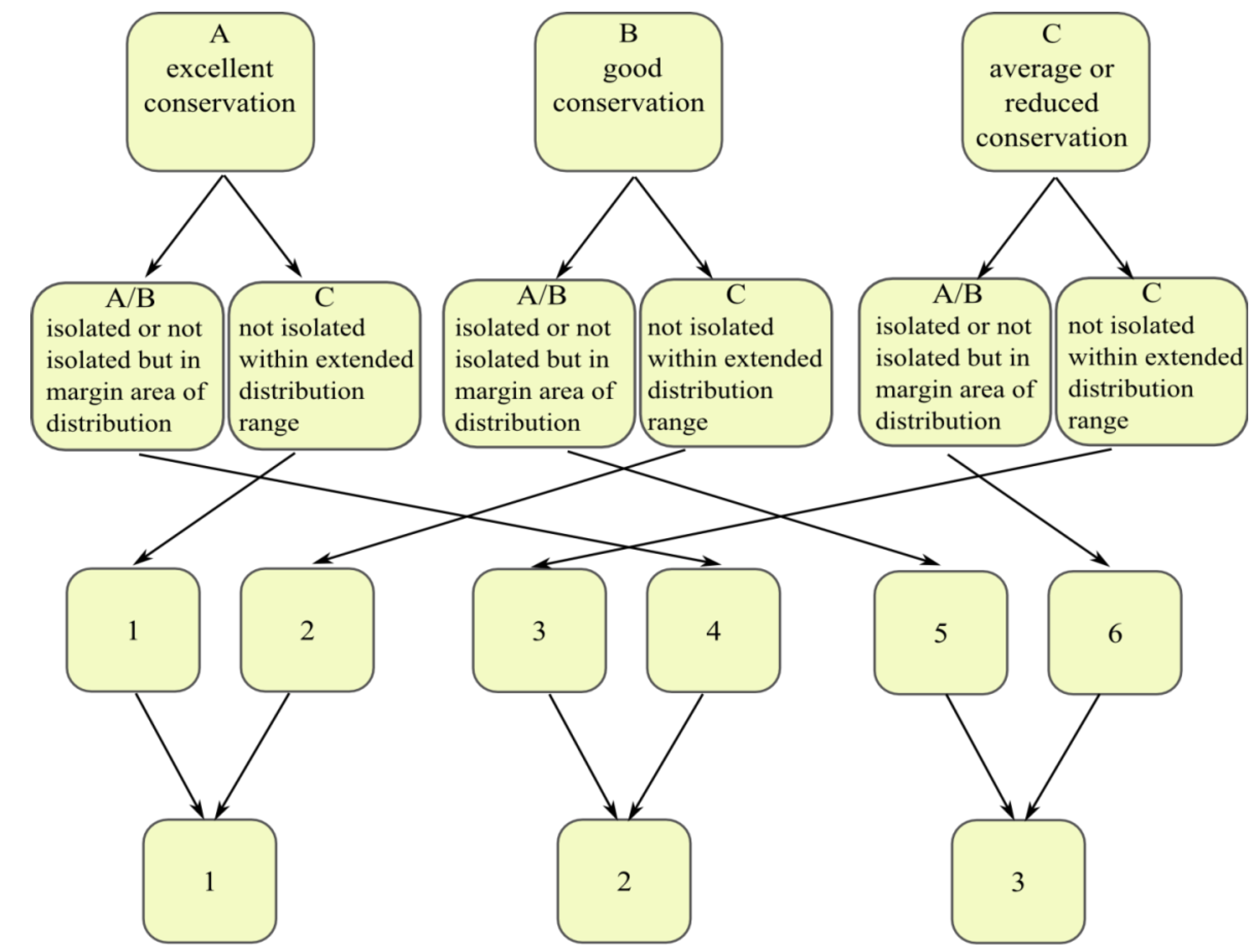
3.7. Calculation of Vulnerability
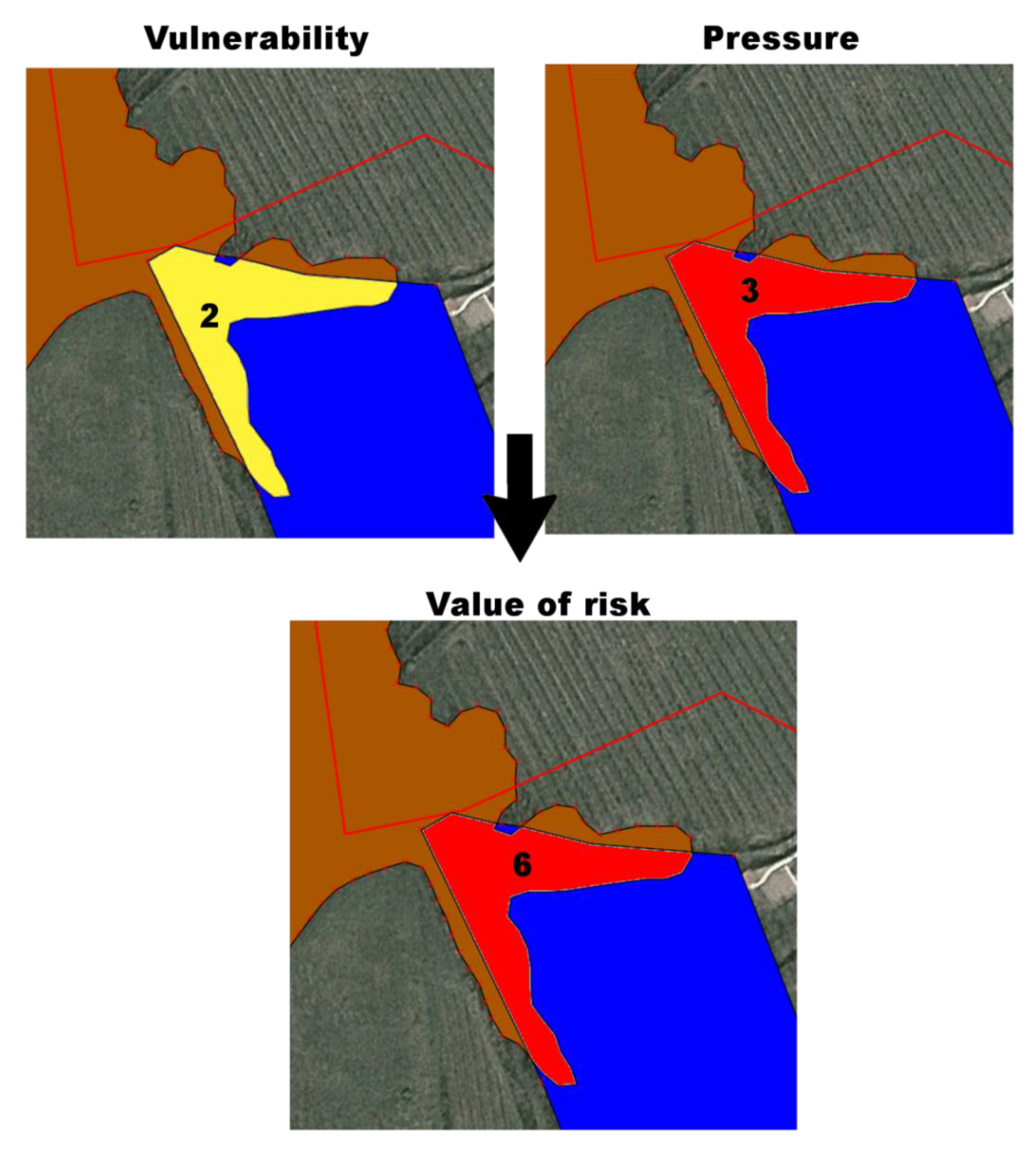
3.8. Calculation of Risk
| Vulnerability | ||||
|---|---|---|---|---|
| 1 | 2 | 3 | ||
| Pressure | 1 | 1 | 2 | 3 |
| 2 | 2 | 4 | 6 | |
| 3 | 3 | 6 | 9 | |
| Value | Risk | Action |
|---|---|---|
| 0 | Null | Monitoring plan |
| 1 | Low: situation potentially stable | Monitoring plan: planning actions in case of an increase in the risk value |
| 2 | Mid: situation potentially unstable | Monitoring plan (high level of monitoring): planning actions in case of an increase in the risk value |
| 3–4 | High: situation potentially serious | Monitoring plan (high level of monitoring): immediate regulations and actions for active management |
| 6 | Very high: situation potentially critic | Monitoring plan (high level of monitoring): urgent regulations and actions for active management |
| 9 | Extreme: situation potentially irreversible | Monitoring plan (high level of monitoring): priority regulations and actions for active management |
4. Conclusions
Acknowledgments
Author Contributions
Conflicts of Interest
References
- Council Directive 92/43/EEC on the Conservation of Natural Habitats and of Wild Fauna and Flora. 21 May 1992. L 206/7. Available online: http://eur-lex.europa.eu/LexUriServ/LexUriServ.do?uri=CELEX:31992L0043:EN:HTML (accessed on 15 March 2014).
- Directive 2009/147/EC of the European Parliament and of the Council on the Conservation of Wild Birds. 2010. L 20/7. Available online: http://eur-lex.europa.eu/LexUriServ/LexUriServ.do?uri%20=OJ:L:2010:020:0007:0025:EN:HTML (accessed on 15 March 2014).
- Commission Implementing Decision 2011/484/EU Concerning a Site Information Format for Natura 2000 Sites. 2011. L198/39. Available online: http://eur-lex.europa.eu/LexUriServ/LexUriServ.do?uri=OJ:L:2011:198:0039:0070:EN:HTML (accessed on 15 March 2014).
- EIONET 2013. Reference List Threats, Pressures and Activities (Final Version)ctivities (Final Version). Available online: http://bd.eionet.europa.eu/activities/Natura_2000/reference_portal (accessed on 12 September 2013).
- MacEwan, R.; Bluml, M.; McNeill, J.; Reynar, K. Land Use Impact Modelling for Native Biodiversity Risk; The State of Victoria, Department of Sustainability and Environment: Victoria, Australia, 2004; pp. 2–16. [Google Scholar]
- Harrington, J.M.; Canter, W.L. Planning environmental monitoring programs within the environmental impact assessment process. Int. J. Environ. Stud. 1998, 55, 305–331. [Google Scholar] [CrossRef]
- Guide 73: 2009 Risk Management—Vocabulary; ISO: Zurich, Switzerland, 2009.
- IEC 31010:2009 Risk Management—Risk Assessment Techniques; ISO/IEC: Zurich, Switzerland, 2009.
- Varens, J. Landslide Hazard Zonation: A Review of Principles and Practice; United Nations Educational: Darantiere, Quetigny, France, 1984; p. 10. [Google Scholar]
- De Lange, H.J.; Sala, S.; Vighi, M.; Faber, J.H. Ecological vulnerability in risk assessment: A review and perspectives. Sci. Total Environ. 2010, 408, 3871–3879. [Google Scholar] [CrossRef]
- Environmental Indicators: Typology and Overview; European Environment Agency: Copenhagen, Denmark, 1999.
- Amajirionwu, M.; Connaughton, N.; McCann, B.; Moles, R.; Bartlett, J.; O’Regan, B. Indicators for managing biosolids in Ireland. J. Environ. Manag. 2008, 88, 1361–1372. [Google Scholar] [CrossRef]
- EEA. Environmental Indicator Report 2012 Ecosystem Resilience and Resource Efficiency in a Green Economy in Europe; Publications Office of the European Union: Luxembourg, Luxembourg, 2012. [Google Scholar]
- Fistanic, I. Sustainable management of brackish karst spring Pantan (Croatia). Acta Carsol. 2006, 35, 65–72. [Google Scholar]
- Haasnoot, M.; van de Wolfshaar, K.E. Combining a conceptual framework and a spatial analysis tool, HABITAT, to support the implementation of river basin management plans. Int. J. River Basin Manag. 2009, 7, 295–311. [Google Scholar] [CrossRef]
- Karageorgis, A.P.; Kapsimalis, V.; Kontogianni, A.; Skourtos, M.; Turner, K.R.; Salomons, W. Impact of 100-year human interventions on the deltaic coastal zone of the inner Thermaikos Gulf (Greece): A DPSIR framework analysis. Environ. Manag. 2006, 38, 304–315. [Google Scholar] [CrossRef]
- Odermatt, S. Evaluation of mountain case studies by means of sustainability variables. Mt. Res. Dev. 2004, 24, 336–341. [Google Scholar] [CrossRef]
- Rekolainen, S.; Hiltunen, M.; Kämäri, J. A conceptual framework for identifying the need and role of models in the implementation of the water framework directive. Int. J. River Basin Manag. 2003, 1, 347–352. [Google Scholar] [CrossRef]
- Salogni, G.; Costa, M.; de Franco, F.; Dorosencu, A.; Kamburov, I.; Ziglio, S.; Loreggian, M.; Gussev, C.; Tzonev, R. BE-Natur: Better Management and Implementation of Natura 2000 Sites. WP3: Transnational Joint Strategy and Tools for the Better Management and Implementation of Natura 2000 Sites. Joint Transnational Action Plan on Coastal Sand Dunes. 2012. Available online: http://www.shape-ipaproject.eu/download/listbox/WP3 action 3.2/Setback Pilot -Veneto Region.pdf (accessed on 14 April 2014).
- Tsai, H.T.; Tzeng, S.Y.; Fu, H.H.; Wu, J.C.T. Managing multinational sustainable development in the European Union based on the DPSIR framework. Afr. J. Bus. Manag. 2009, 3, 727–735. [Google Scholar]
- Walmsley, J.J. Framework for measuring sustainable development in catchment systems. Environ. Manage. 2002, 29, 195–206. [Google Scholar] [CrossRef]
- Wei, J.; Zhao, Y.; Xu, H.; Yu, H. A framework for selecting indicators to assess the sustainable development of the natural heritage site. J. Mt. Sci. 2007, 4, 321–330. [Google Scholar] [CrossRef]
- Commission of the European Communities. Communication from the Commission on the Precautionary Principle; Commission of the European Communities: Brussels, Belgium, 2000. [Google Scholar]
- European Communities. Article 6(2). In Managing Natura 2000 Sites. The Provisions of Article 6 of the “Habitats” Directive 92/43/EEC; European Communities: Bruxelles, Belgium, 2000; pp. 24–29. [Google Scholar]
- European Communities. Assessment of Plans and Projects Significantly Affecting Natura 2000 Sites Methodological Guidance on the Provisions of Article 6(3) and (4) of the Habitats Directive 92/43/EEC; European Communities: Luxembourg, Luxembourg, 2000; p. 12. [Google Scholar]
- Chapman, C.; Ward, S. Project Risk Management Processes, Techniques and Insights; John Wiley & Sons Ltd.: Chichester, UK, 2003; p. 6. [Google Scholar]
- Iscan, M. Hazard identification for contaminants. Toxicology 2004, 205, 195–199. [Google Scholar] [CrossRef]
- Guidelines for Ecological Risk Assessment; U.S. Environmental Protection Agency: Washington, DC, USA, 1998.
- Framework for Ecological Risk Assessments; Risk Assessment Forum, U.S. Environmental Protection Agency: Washington, DC, USA, 1992.
- U.S. EPA. EPA Risk Assessment Basic Information. 2013. Available online: http://www.epa.gov/risk/basicinformation.htm (accessed on 5 February 2013).
- De Lange, H.J.; van der Pol, J.J.C.; Lahr, J.; Faber, J.H. Ecological Vulnerability in Wildlife. In A Conceptual Approach to Assess Impact of Environmental Stressors, Alterra Report 1305; Alterra: Wageningen, The Netherlands, 2005; p. 112. [Google Scholar]
- De Lange, H.J.; Lahr, J.; van der Pol, J.J.C.; Wessels, Y.; Faber, J.H. Ecological vulnerability in wildlife: An expert judgment and multi-criteria analysis tool using ecological traits to assess relative impact of pollutants. Environ. Toxicol. Chem. 2009, 28, 2233–2240. [Google Scholar] [CrossRef]
- Agarwal, C.; Green, G.L.; Grove, M.; Evans, T.; Schweik, C. A Review and Assessment of Land-use Change Models Dynamics of Space, Time, and Human Choice; Center for the Study of Institutions Population, and Environmental Change: Bloomington, IN, USA, 2000; pp. 3–10. [Google Scholar]
- Rykiel, E.J. Towards a definition of ecological disturbance. Aust. J. Ecol. 1985, 10, 361–365. [Google Scholar] [CrossRef]
- Fahrig, L. Relative importance of spatial and temporal scales in patcher environment. Theor. Pop. Biol. 1992, 41, 300–314. [Google Scholar] [CrossRef]
- Murray, S.L.; Grantham, K.B.; Damle, S.B. Development of a generic risk matrix to manage project risks. J. Ind. Syst. Eng. 2011, 5, 35–51. [Google Scholar]
- Landscape Fragmentation in Europe; EEA Report No. 2/2011; Publications Office of the European Union, European Environment Agency: Copenhagen, Denmark, 2011.
- EEA. Europe’s Environment. The Dobris Assessment. European Environment Agency: Copenhagen, 1995. Available online: http://www.eea.europa.eu/publications/92-826-5409-5/page009new.html (accessed on 11 September 2013).
- Pirotti, F.; Guarnieri, A.; Vettore, A. Collaborative Web-GIS design: A case study for road risk analysis and monitoring. Trans. GIS 2011, 15, 213–226. [Google Scholar] [CrossRef]
- Linneaus, C. Systema Naturae; Imprensis Laurentii Salvii: Holmiae, Sweden, 1758; Volume 1, p. 46. [Google Scholar]
- Eigenbrod, F.; Fahrig, L.; Hecnar, S.J. Accessible habitat: An improved measure of the effects of habitat loss and roads on wildlife populations. Landscape Ecol. 2008, 23, 159–168. [Google Scholar] [CrossRef]
- Hunsaker, C.T.; Graham, R.L.; Suter, G.W.; O’neill, R.V.; Barnthouse, L.W.; Gardner, R.H. Assessing ecological risk on a regional scale. Environ. Manag. 1990, 14, 325–332. [Google Scholar]
- Piragnolo, M. Sistema di Supporto per la Valutazione di Impatti Sulla Biodiversità. Master Thesis, IUAV University, Venice, Italy, 27 Junuary 2012. [Google Scholar]
- Jaeger, J.A.G. Effects of the Configuration of Road Networks on Landscape Connectivity. UC Davis Road Ecology Center, 2007. Available online: http://www.escholarship.org/uc/item/10d5q9nj (accessed on 10 September 2013).
- Ministero dell’Ambiente e delal Tutela del Territorio. Natura 2000 Formulario Standard per Zone di Protezione Speciale (ZPS) per Zone Proponibili pèer una Identificazione Come siti d’importanza Comunitaria (SIC) e per Zone Speciali di Conservazione (ZSC). Available online: http://www.regione.veneto.it/web/ambiente-e-territorio/rete-natura-2000-download#IT3220037 (accessed on 8 February 2014).
- Brovelli, M.A.; Minghini, M.; Zamboni, G. Public participation GIS: A FOSS architecture enabling field-data collection. Int. J. Digit. Earth 2014. [Google Scholar] [CrossRef]
© 2014 by the authors; licensee MDPI, Basel, Switzerland. This article is an open access article distributed under the terms and conditions of the Creative Commons Attribution license (http://creativecommons.org/licenses/by/3.0/).
Share and Cite
Piragnolo, M.; Pirotti, F.; Guarnieri, A.; Vettore, A.; Salogni, G. Geo-Spatial Support for Assessment of Anthropic Impact on Biodiversity. ISPRS Int. J. Geo-Inf. 2014, 3, 599-618. https://doi.org/10.3390/ijgi3020599
Piragnolo M, Pirotti F, Guarnieri A, Vettore A, Salogni G. Geo-Spatial Support for Assessment of Anthropic Impact on Biodiversity. ISPRS International Journal of Geo-Information. 2014; 3(2):599-618. https://doi.org/10.3390/ijgi3020599
Chicago/Turabian StylePiragnolo, Marco, Francesco Pirotti, Alberto Guarnieri, Antonio Vettore, and Gianluca Salogni. 2014. "Geo-Spatial Support for Assessment of Anthropic Impact on Biodiversity" ISPRS International Journal of Geo-Information 3, no. 2: 599-618. https://doi.org/10.3390/ijgi3020599
APA StylePiragnolo, M., Pirotti, F., Guarnieri, A., Vettore, A., & Salogni, G. (2014). Geo-Spatial Support for Assessment of Anthropic Impact on Biodiversity. ISPRS International Journal of Geo-Information, 3(2), 599-618. https://doi.org/10.3390/ijgi3020599