Metadata Quality and Discoverability in the NCCU CoDE Open Data Hub: A FAIR- and FGDC CSDGM-Informed Assessment



Abstract
1. Introduction
- To what extent do current CoDE Hub items support Findability, Accessibility, Interoperability, and Reusability through the metadata evidence available in ArcGIS item records, formal metadata, and layer properties?
- How do FAIR-aligned and FGDC CSDGM-informed metadata scores vary across item types and individual criteria?
- How effectively can public users locate Hub items through exact-title, thematic, geographic, type-based, and category-based discovery pathways?
2. Background and Conceptual Framework
2.1. University Geospatial Hubs as Spatial Data Infrastructure
2.2. Metadata Quality and Geospatial Reuse
2.3. FAIR Principles as the Organizing Framework
2.4. Discoverability as an Outcome of Metadata and Catalog Design
2.5. Study Contribution
3. Materials and Methods
3.1. Study Design and Assessment Date

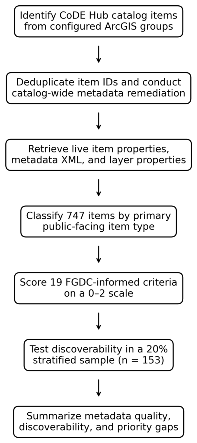
3.2. Catalog Inventory and Unit of Analysis
- retrieval and deduplication of item identifiers from catalog groups;
- collection of current item-page properties, including title, summary, description, tags, categories, credits, terms of use, access level, owner, item type, and creation and modification dates;
- download and parsing of standards-based metadata XML where available;
- retrieval of feature-layer geometry, spatial reference, and field information where accessible; and
- classification of each item according to its primary public-facing function.
3.3. FAIR- and FGDC CSDGM-Informed Assessment Framework

| Criterion | FGDC Content Area | Primary FAIR Dimension | Secondary Relationship | Functional Rationale |
|---|---|---|---|---|
| Title clarity | Identification information | Findable | Reusable | Supports discovery and later interpretation. |
| Abstract/description | Identification information | Findable | Reusable | Rich description supports search and fitness-for-use judgments. |
| Purpose | Identification information | Reusable | Findable | Intended use supports reuse; purpose terms may also aid discovery. |
| Theme keywords | Identification information | Findable | Interoperable | Indexing terms support retrieval; controlled terms can support semantic interoperability. |
| Place keywords | Identification information | Findable | Interoperable | Geographic terms support spatial discovery; controlled gazetteers can support interoperability. |
| Access constraints | Identification information | Accessible | Reusable | States retrieval conditions and affects permissible downstream use. |
| Use constraints | Identification information | Reusable | Accessible | Defines permissions or limitations and may include access-related conditions. |
| Data source | Data quality information | Reusable | Interoperable | Source attribution supports trust, provenance, and linking. |
| Lineage/process notes | Data quality information | Reusable | Interoperable | Processing history supports provenance and integration decisions. |
| Completeness/limitations | Data quality information | Reusable | None | Supports fitness-for-use and responsible interpretation. |
| Data type/geometry | Spatial data organization | Interoperable | Findable | Resource structure supports integration and type-based discovery. |
| Spatial reference | Spatial reference information | Interoperable | Reusable | Coordinate reference supports correct integration and fitness-for-use. |
| Attribute definitions | Entity and attribute information | Interoperable | Reusable | Schema meaning supports interpretation, integration, and reuse. |
| Access/download options | Distribution information | Accessible | Findable | Provides retrieval mechanisms and a reachable resource path. |
| Distribution format | Distribution information | Accessible | Interoperable | Describes delivery mechanism and technical compatibility. |
| Distributor/contact | Distribution information | Accessible | Reusable | Identifies a responsible access point and accountable steward. |
| Date created/published | Metadata reference information | Findable | Reusable | Supports indexing, citation context, and temporal interpretation. |
| Date modified/updated | Metadata reference information | Findable | Reusable | Supports discovery by currency and assessment of currentness. |
| Metadata contact/date | Metadata reference information | Reusable | Accessible | Supports metadata responsibility, maintenance, and clarification. |
3.4. Scoring, Weighting, Applicability, and Descriptive Performance Bands
| Performance Band | Percentage Range | Average Criterion Score | Interpretation |
|---|---|---|---|
| High | 75.00–100.00% | 1.50–2.00 | Predominantly complete/useful evidence |
| Moderate | 50.00–74.99% | 1.00–1.49 | At least partial/weak evidence on average |
| Low | Below 50.00% | Below 1.00 | Less than partial/weak evidence on average |
3.5. Discoverability Assessment
| Band | Search Score | Click-Depth | Interpretation |
|---|---|---|---|
| High | At least 75% | No more than 3 clicks | Strong retrieval and a direct navigation path |
| Moderate | At least 50% | No more than 4 clicks | Adequate retrieval with limited additional navigation |
| Low | Below 50% or more than 4 clicks | More than 4 clicks where applicable | Weak retrieval or substantial navigation burden |
3.6. Analysis, Robustness, and Quality Control
4. Results
4.1. Catalog Composition
| Percentage | Number | Item Type |
|---|---|---|
| 29.85% | 223 | Dataset/hosted feature layer |
| 21.55% | 161 | Web map |
| 8.57% | 64 | Web application |
| 1.61% | 12 | Dashboard |
| 6.96% | 52 | StoryMap |
| 23.16% | 173 | Document/file resource |
| 0.40% | 3 | Training resource |
| 7.90% | 59 | Other |
| 100.00% | 747 | Total |
4.2. Overall Metadata Descriptive Performance
| Percentage | Number | Performance Band |
|---|---|---|
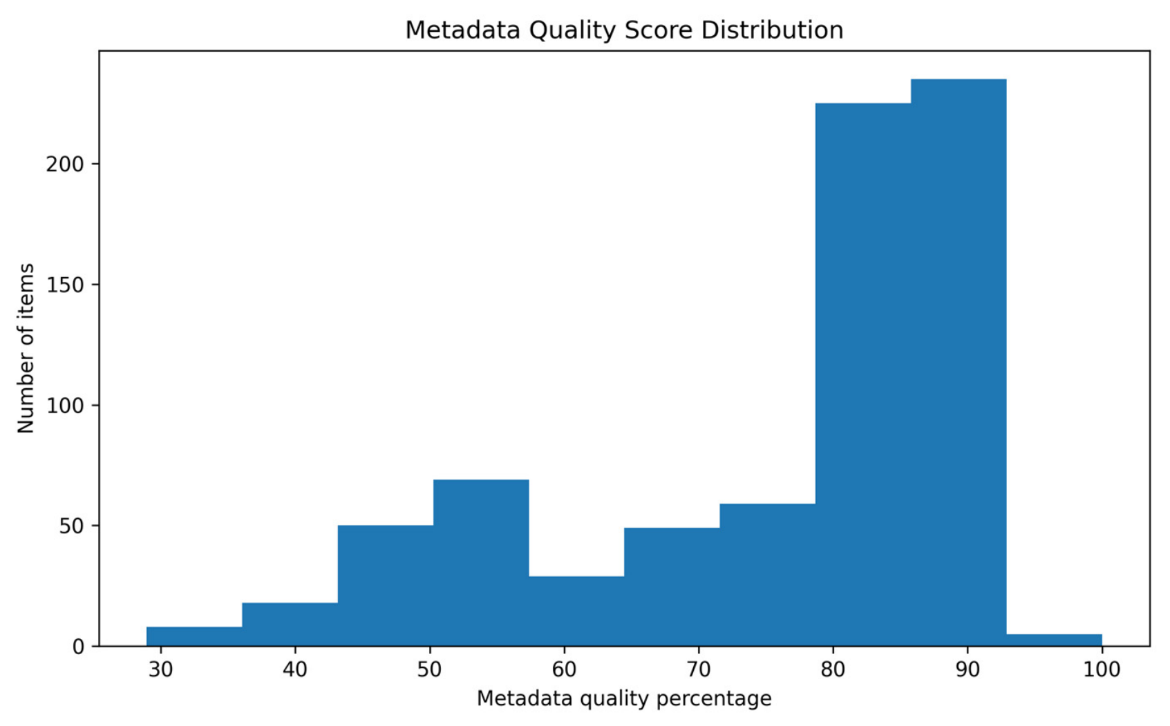
| 65.60% | 490 | High |
| 27.71% | 207 | Moderate |
| 6.69% | 50 | Low |
| 100.00% | 747 | Total |

4.3. FAIR-Aligned Performance
| Indicators Included | Mean % | Mean Score/Max | Criteria (n) | FAIR Dimension |
|---|---|---|---|---|
| Title, abstract, theme/place keywords, creation and modification dates | 87.25% | 10.47/12 | 6 | Findable |
| Access constraints, access/download, distribution format, distributor/contact | 85.96% | 6.88/8 | 4 | Accessible |
| Data type/geometry, spatial reference, attribute definitions | 52.59% | 3.16/6 | 3 | Interoperable |
| Purpose, use constraints, source, lineage, limitations, metadata contact/date | 67.26% | 8.07/12 | 6 | Reusable |
4.4. Completeness by FGDC-Informed Dimension and Criterion
| Weakest Criterion | Strongest Criterion | Mean % | Mean Score/Max | Dimension |
|---|---|---|---|---|
| Place keywords | Abstract/description | 79.87% | 11.18/14 | Identification information |
| Lineage/process notes | Data source | 54.66% | 3.28/6 | Data quality information |
| Data type/geometry | Data type/geometry | 98.26% | 1.97/2 | Spatial data organization |
| Spatial reference | Spatial reference | 16.00% | 0.32/2 | Spatial reference information |
| Attribute definitions | Attribute definitions | 43.51% | 0.87/2 | Entity and attribute information |
| Access/download options | Distribution format | 90.90% | 5.45/6 | Distribution information |
| Metadata contact/date | Date created/published | 91.70% | 5.50/6 | Metadata reference information |
| Mean/2 | Missing n (%) | Partial n (%) | Complete n (%) | Criterion |
|---|---|---|---|---|
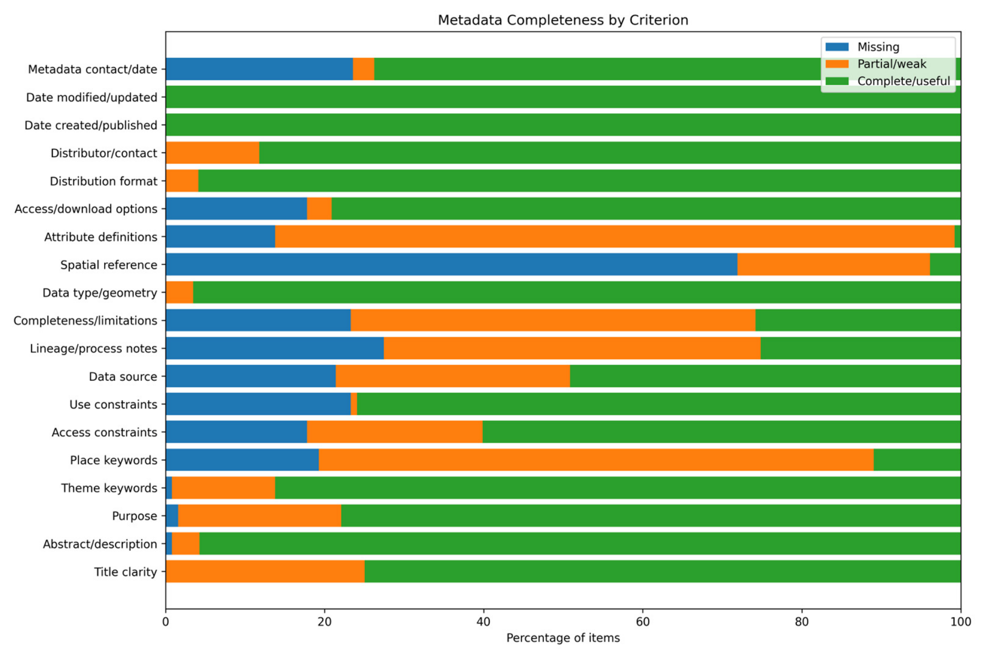
| 1.75 | 0 (0.00%) | 187 (25.03%) | 560 (74.97%) | Title clarity |
| 1.95 | 6 (0.80%) | 26 (3.48%) | 715 (95.72%) | Abstract/description |
| 1.76 | 12 (1.61%) | 153 (20.48%) | 582 (77.91%) | Purpose |
| 1.85 | 6 (0.80%) | 97 (12.99%) | 644 (86.21%) | Theme keywords |
| 0.92 | 144 (19.28%) | 521 (69.75%) | 82 (10.98%) | Place keywords |
| 1.42 | 133 (17.80%) | 165 (22.09%) | 449 (60.11%) | Access constraints |
| 1.53 | 174 (23.29%) | 6 (0.80%) | 567 (75.90%) | Use constraints |
| 1.28 | 160 (21.42%) | 220 (29.45%) | 367 (49.13%) | Data source |
| 0.98 | 205 (27.44%) | 354 (47.39%) | 188 (25.17%) | Lineage/process notes |
| 1.03 | 174 (23.29%) | 380 (50.87%) | 193 (25.84%) | Completeness/limitations |
| 1.97 | 0 (0.00%) | 26 (3.48%) | 721 (96.52%) | Data type/geometry |
| 0.32 | 537 (71.89%) | 181 (24.23%) | 29 (3.88%) | Spatial reference |
| 0.87 | 103 (13.79%) | 638 (85.41%) | 6 (0.80%) | Attribute definitions |
| 1.61 | 133 (17.80%) | 23 (3.08%) | 591 (79.12%) | Access/download options |
| 1.96 | 0 (0.00%) | 31 (4.15%) | 716 (95.85%) | Distribution format |
| 1.88 | 0 (0.00%) | 88 (11.78%) | 659 (88.22%) | Distributor/contact |
| 2.00 | 0 (0.00%) | 0 (0.00%) | 747 (100.00%) | Date created/published |
| 2.00 | 0 (0.00%) | 0 (0.00%) | 747 (100.00%) | Date modified/updated |
| 1.50 | 176 (23.56%) | 20 (2.68%) | 551 (73.76%) | Metadata contact/date |

4.5. Metadata Descriptive Performance by Item Type
| Performance Band | Mean % | Mean Score/38 | n | Item Type |
|---|---|---|---|---|
| Moderate | 66.10% | 25.12 | 223 | Dataset/hosted feature layer |
| High | 78.62% | 29.88 | 161 | Web map |
| High | 76.69% | 29.14 | 64 | Web application |
| High | 82.46% | 31.33 | 12 | Dashboard |
| High | 81.88% | 31.12 | 52 | StoryMap |
| High | 82.31% | 31.28 | 173 | Document/file resource |
| High | 76.31% | 29.00 | 3 | Training resource |
| Moderate | 70.29% | 26.71 | 59 | Other |
4.6. Discoverability
| Percentage | Number | Discoverability Class |
|---|---|---|
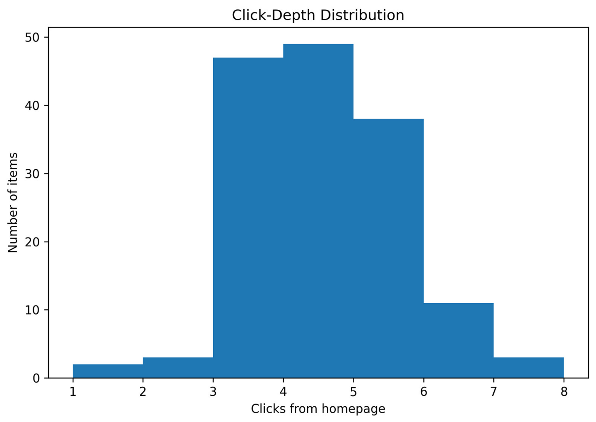
| 28.10% | 43 | High |
| 37.91% | 58 | Moderate |
| 33.99% | 52 | Low |
| 100.00% | 153 | Total |
| Unsuccessful n (%) | Partial n (%) | Successful n (%) | Test |
|---|---|---|---|
| 0 (0.00%) | 0 (0.00%) | 153 (100.00%) | Exact-title search |
| 0 (0.00%) | 18 (11.76%) | 135 (88.24%) | Keyword search |
| 2 (1.34%) | 141 (94.63%) | 6 (4.03%) | Location search |
| 0 (0.00%) | 0 (0.00%) | 153 (100.00%) | Data-type search |
| 34 (22.22%) | 74 (48.37%) | 45 (29.41%) | Category browsing |

4.7. Robustness and Sensitivity Analyses
4.8. Inter-Assessor Reliability
5. Discussion
5.1. FAIR Profile of the CoDE Hub
5.2. Interoperability and Reusability
5.3. Discoverability and Catalog Navigation
5.4. Implications for Ongoing CoDE Hub Development
5.5. Methodological Contribution and Transferability
5.6. Limitations and Future Evaluation
6. Conclusions
Author Contributions
Funding
Data Availability Statement
Acknowledgments
Conflicts of Interest
References
- Rajabifard, A.; Feeney, M.-E.F.; Williamson, I.P. Future directions for SDI development. Int. J. Appl. Earth Obs. Geoinf. 2002, 4, 11–22. [Google Scholar] [CrossRef] [Scilit]
- Hardy, D.; Durante, K. A metadata schema for geospatial resource discovery use cases. Code4Lib J. 2014, 25. Available online: https://journal.code4lib.org/articles/9710 (accessed on 19 June 2026).
- Longley, P.A.; Goodchild, M.F.; Maguire, D.J.; Rhind, D.W. Geographic Information Science and Systems, 4th ed.; Wiley: Chichester, UK, 2015. [Google Scholar]
- Quarati, A.; De Martino, M.; Rosim, S. Geospatial open data usage and metadata quality. ISPRS Int. J. Geo-Inf. 2021, 10, 30. [Google Scholar] [CrossRef] [Scilit]
- Wilkinson, M.D.; Dumontier, M.; Aalbersberg, I.J.; Appleton, G.; Axton, M.; Baak, A.; Blomberg, N.; Boiten, J.-W.; da Silva Santos, L.B.; Bourne, B.E. The FAIR guiding principles for scientific data management and stewardship. Sci. Data 2016, 3, 160018. [Google Scholar] [CrossRef] [Scilit]
- Bruce, T.R.; Hillmann, D.I. The continuum of metadata quality: Defining, expressing, exploiting. In Metadata in Practice; Hillmann, D.I., Westbrooks, E.L., Eds.; American Library Association: Chicago, IL, USA, 2004; pp. 238–256. [Google Scholar]
- Park, J.-R. Metadata quality in digital repositories: A survey of the current state of the art. Cat. Classif. Q. 2009, 47, 213–228. [Google Scholar] [CrossRef] [Scilit]
- Ochoa, X.; Duval, E. Automatic evaluation of metadata quality in digital repositories. Int. J. Digit. Libr. 2009, 10, 67–91. [Google Scholar] [CrossRef] [Scilit]
- Vetrò, A.; Canova, L.; Torchiano, M.; Minotas, C.O.; Iemma, R.; Morando, F. Open data quality measurement framework: Definition and application to open government data. Gov. Inf. Q. 2016, 33, 325–337. [Google Scholar] [CrossRef] [Scilit]
- Neumaier, S.; Umbrich, J.; Polleres, A. Automated quality assessment of metadata across open data portals. J. Data Inf. Qual. 2016, 8, 2. [Google Scholar] [CrossRef] [Scilit]
- Machova, R.; Lnenicka, M. Evaluating the quality of open data portals on the national level. J. Theor. Appl. Electron. Commer. Res. 2017, 12, 21–41. [Google Scholar] [CrossRef] [Scilit]
- Kubler, S.; Robert, J.; Neumaier, S.; Umbrich, J.; Le Traon, Y. Comparison of metadata quality in open data portals using the analytic hierarchy process. Gov. Inf. Q. 2018, 35, 13–29. [Google Scholar] [CrossRef] [Scilit]
- Nogueras-Iso, J.; Lacasta, J.; Urena-Camara, M.A.; Ariza-Lopez, F.J. Quality of metadata in open data portals. IEEE Access 2021, 9, 60364–60382. [Google Scholar] [CrossRef] [Scilit]
- Esri. Metadata in ArcGIS Online. Available online: https://doc.arcgis.com/en/arcgis-online/manage-data/metadata.htm (accessed on 19 June 2026).
- Esri. Add and Manage Content—ArcGIS Hub. Available online: https://doc.arcgis.com/en/hub/content/add-content.htm (accessed on 19 June 2026).
- Esri. Explore Content—ArcGIS Hub. Available online: https://doc.arcgis.com/en/hub/content/explore-content.htm (accessed on 19 June 2026).
- Harvey, F. A Primer of GIS: Fundamental Geographic and Cartographic Concepts, 2nd ed.; Guilford Press: New York, NY, USA, 2016. [Google Scholar]
- Kresse, W.; Danko, D.M. (Eds.) Springer Handbook of Geographic Information; Springer: Berlin, Germany, 2012. [Google Scholar] [CrossRef] [Scilit]
- FGDC-STD-001-1998; Content Standard for Digital Geospatial Metadata, Version 2. Federal Geographic Data Committee: Washington, DC, USA, 1998. Available online: https://www.fgdc.gov/standards/projects/metadata/base-metadata/v2_0698.pdf (accessed on 19 June 2026).
- ISO 19157:2013; Geographic Information—Data Quality. ISO: Geneva, Switzerland, 2013.
- ISO 19115-1:2014; Geographic Information—Metadata—Part 1: Fundamentals. ISO: Geneva, Switzerland, 2014.
- Devillers, R.; Bédard, Y.; Jeansoulin, R. Multidimensional management of geospatial data quality information for its dynamic use within GIS. Photogramm. Eng. Remote Sens. 2005, 71, 205–215. [Google Scholar] [CrossRef] [Scilit]
- Wagner, M.; Henzen, C. Quality assurance for spatial research data. ISPRS Int. J. Geo-Inf. 2022, 11, 334. [Google Scholar] [CrossRef] [Scilit]
- Batcheller, J.K. Automating geospatial metadata generation—An integrated data management and documentation approach. Comput. Geosci. 2008, 34, 387–398. [Google Scholar] [CrossRef] [Scilit]
- Batcheller, J.K.; Gittings, B.M.; Dunfey, R.I. A method for automating geospatial dataset metadata. Future Internet 2009, 1, 28–46. [Google Scholar] [CrossRef] [Scilit]
- Florczyk, A.J.; López-Pellicer, F.J.; Nogueras-Iso, J.; Zarazaga-Soria, F.J. Automatic generation of geospatial metadata for web resources. Int. J. Spat. Data Infrastruct. Res. 2012, 7, 151–172. [Google Scholar] [CrossRef]
- Giuliani, G.; Guigoz, Y.; Lacroix, P.; Ray, N.; Lehmann, A. Facilitating the production of ISO-compliant metadata of geospatial datasets. Int. J. Appl. Earth Obs. Geoinf. 2016, 44, 239–243. [Google Scholar] [CrossRef] [Scilit]
- Trilles, S.; Díaz, L.; Huerta, J. Approach to facilitating geospatial data and metadata publication using a standard geoservice. ISPRS Int. J. Geo-Inf. 2017, 6, 126. [Google Scholar] [CrossRef] [Scilit]
- Wang, Z.; Shi, X.; Yang, H.; Yu, B.; Cai, Y. Automatic Extraction and Cluster Analysis of Natural Disaster Metadata Based on the Unified Metadata Framework. ISPRS Int. J. Geo-Inf. 2024, 13, 201. [Google Scholar] [CrossRef] [Scilit]
- Hutchison, V.B.; Norkin, T.; Zolly, L.S.; Hsu, L. State of the Data: Assessing the FAIRness of US Geological Survey Data. Data Sci. J. 2024, 23, 22. [Google Scholar] [CrossRef] [Scilit]
- RDA FAIR Data Maturity Model Working Group. FAIR Data Maturity Model: Specification and Guidelines; Research Data Alliance: Didcot, UK, 2020. [CrossRef]
- Candela, L.; Mangione, D.; Pavone, G. The FAIR Assessment Conundrum: Reflections on Tools and Metrics. Data Sci. J. 2024, 23, 33. [Google Scholar] [CrossRef] [Scilit]
- Minghini, M.; Escriu, J.; Kotsev, A. Monitoring the FAIRness of geospatial data: Lessons learnt from the European Union. Int. Arch. Photogramm. Remote Sens. Spat. Inf. Sci. 2025, 48, 179–184. [Google Scholar] [CrossRef] [Scilit]
- Ponciano, C.; Würriehausen, F.; Schaffert, M.; Müller, H.; Ponciano, J.-J. From Stars to LETTERS: A Multi-Dimensional, FAIR-Aligned Framework for Geospatial Metadata Quality Evaluation. ISPRS Int. J. Geo-Inf. 2026, 15, 197. [Google Scholar] [CrossRef] [Scilit]
- Ivánová, I.; Brown, N.; Fraser, R.; Tengku, N.; Rubinov, E. FAIR and standard access to spatial data as the means for achieving sustainable development goals. Int. Arch. Photogramm. Remote Sens. Spat. Inf. Sci. 2019, 42, 33–39. [Google Scholar] [CrossRef] [Scilit]
- Thompson, P.T.; Ojha, S.; Powell, C.D.; Pennell, K.G.; Moseley, H.N.B. A proposed FAIR approach for disseminating geospatial information system maps. Sci. Data 2023, 10, 389. [Google Scholar] [CrossRef] [Scilit]
- Machova, R.; Hub, M.; Lnenicka, M. Usability evaluation of open data portals: Evaluating data discoverability, accessibility, and reusability from a stakeholders’ perspective. Aslib J. Inf. Manag. 2018, 70, 252–268. [Google Scholar] [CrossRef] [Scilit]
- Kalantari, M.; Syahrudin, S.; Rajabifard, A.; Subagyo, H.; Hubbard, H. Spatial metadata usability evaluation. ISPRS Int. J. Geo-Inf. 2020, 9, 463. [Google Scholar] [CrossRef] [Scilit]
- Ferrari, E.; Striewski, F.; Tiefenbacher, F.; Bereuter, P.; Oesch, D.; Di Donato, P. Search Engine for Open Geospatial Consortium Web Services Improving Discoverability through Natural Language Processing-Based Processing and Ranking. ISPRS Int. J. Geo-Inf. 2024, 13, 128. [Google Scholar] [CrossRef] [Scilit]
- Król, K. Retrospective Analysis of Municipal Geoportal Usability in the Context of the Evolution of Online Data Presentation Techniques. ISPRS Int. J. Geo-Inf. 2024, 13, 307. [Google Scholar] [CrossRef] [Scilit]
- Ankama, S.; Degbelo, A.; Naoseb, E.; Henzen, C.; Bernard, L. How Well Do Current Geoportals Support Geodata Discovery? An Empirical Study. ISPRS Int. J. Geo-Inf. 2026, 15, 82. [Google Scholar] [CrossRef] [Scilit]
- Kalantari, M.; Rajabifard, A.; Olfat, H.; Williamson, I. Geospatial metadata 2.0—An approach for volunteered geographic information. Comput. Environ. Urban Syst. 2014, 48, 35–48. [Google Scholar] [CrossRef] [Scilit]
- Mulrooney, T. Facilitating a statewide GIS metadata standard through training, outreach and programmatic metadata evaluation. Int. J. Adv. Softw. 2019, 12, 166–178. [Google Scholar]
- Mulrooney, T. Facilitating the New Statewide GIS Metadata Standard through Training and Outreach; NCDOT Project 2017-20, Report FHWA/NC/2017-20; North Carolina Central University: Durham, NC, USA, 2019. Available online: https://connect.ncdot.gov/projects/research/RNAProjDocs/2017-20FinalReport.pdf (accessed on 19 June 2026).
- Mulrooney, T. Turning Data into Information: Assessing and Reporting GIS Metadata Integrity Using Integrated Computing Technologies. Ph.D. Thesis, University of North Carolina at Greensboro, Greensboro, NC, USA, 2009. [Google Scholar]
| Criterion | 0—Missing | 1—Partial/Weak | 2—Complete/Useful |
|---|---|---|---|
| Title clarity | Blank or absent | Date/code-only, generic, or unclear title | Specific, understandable, distinguishable title |
| Abstract/description | No abstract or description | Present but short, generic, or placeholder-like | Specific description with sufficient explanatory detail |
| Purpose | No purpose statement | Present but short or generic | Clear intended purpose or use |
| Theme keywords | No meaningful theme keywords | One or two meaningful keywords | Three or more meaningful subject keywords |
| Place keywords | No geographic keyword or description | Only broad geography such as North Carolina | Specific place keywords or clear geographic coverage |
| Access constraints | Access status unavailable or item inaccessible | Public status only, without an explicit constraint statement | Public status plus explicit access-constraint information |
| Use constraints | No terms, license, or use limitation | Generic or brief statement | Clear restrictions, permissions, license, or item-relevant limitations |
| Data source | No source or credit | Only owner/publisher or generic organization | Specific source, creator, program, agency, or source URL |
| Lineage/process notes | No process information | Generic or brief process statement | Specific creation, processing, geocoding, derivation, or update information |
| Completeness/limitations | No limitations or quality information | Generic disclaimer | Clear accuracy, completeness, limitation, uncertainty, or known-issue statement |
| Data type/geometry | Type unavailable | General item type only | Specific resource type and/or geometry information |
| Spatial reference | No coordinate-system information | WKID or generic spatial representation only | Coordinate system, projection, datum, or equivalent reference sufficiently identified |
| Attribute definitions | No field or attribute information | Fields exist or a generic attribute statement is present | Useful definitions of fields, variables, units, codes, or domains |
| Access/download options | Item inaccessible | View-only access | Public view plus download, service, file, API, or open-resource access |
| Distribution format | No format information | Item type only | Specific file type, service type, or distribution method |
| Distributor/contact | No publisher or contact | Owner or organization only | Named person/unit, email, phone, or clearly responsible organization |
| Date created/published | No date | Only metadata date or unclear date | Creation/publication date available |
| Date modified/updated | No date | Only unclear revision reference | Modification/update date available |
| Metadata contact/date | Neither available | Contact or metadata date available | Both metadata contact and metadata date available |
| Test | Procedure | 0/1/2 Scoring Logic | Purpose |
|---|---|---|---|
| Exact-title search | Search the complete public item title. | 0: not found; 1: found only after minor title normalization or one refinement; 2: found with the complete title query. | Known-item retrieval |
| Keyword search | Search one or two substantive terms from the title or description. | 0: not found; 1: found after one refinement or difficult to distinguish among broad results; 2: found with the initial substantive query. | Thematic retrieval without exact-title knowledge |
| Location search | Search a relevant place name when applicable. | 0: not found; 1: returned among many same-context results or after one refinement; 2: clearly retrieved by a specific place query. | Place-based retrieval |
| Data-type search | Search or filter by broad item type, such as web map, dataset, dashboard, or StoryMap. | 0: not found; 1: found only after refinement; 2: found through the initial type-based pathway. | Retrieval by resource type |
| Category browsing | Navigate from the homepage through catalog categories or collections. | 0: no appropriate path; 1: indirect path or additional traversal required; 2: appropriate category directly retrieved the item. | Browsing through information architecture |
| Click-depth | Count discrete user-initiated actions from the homepage to the public item page or usable resource. | Recorded separately; scrolling and browser-back actions were not counted. | Navigation burden |
| Reliability Measure | Result |
|---|---|
| Items independently rescored | 50 (6.69% of catalog) |
| Paired criterion ratings | 950 |
| Exact criterion agreement | 76.74% (729/950) |
| Linear weighted Cohen’s kappa | 0.587 |
| Quadratic weighted Cohen’s kappa | 0.630 |
| Mean total score /38 | Original: 28.86; second assessor: 29.60 |
| Absolute-agreement ICC(A,1) | 0.715 |
| Performance-band agreement | 82.00% (41/50) |
| Band-level Cohen’s kappa | 0.566 |
| Scenario | Mean (%) | High n (%) | Moderate n (%) | Low n (%) | Stability Relative to Benchmark |
|---|---|---|---|---|---|
| Equal-criterion benchmark (19 criteria; 75/50 bands) | 75.19 | 490 (65.60%) | 207 (27.71%) | 50 (6.69%) | Reference |
| Equal FAIR-dimension weighting (75/50 bands) | 73.26 | 467 (62.52%) | 234 (31.33%) | 46 (6.16%) | rho = 0.988; 716 (95.85%) same band |
| Core-plus-extension applicability normalization (75/50 bands) | 79.93 | 529 (70.82%) | 179 (23.96%) | 39 (5.22%) | rho = 0.977; 697 (93.31%) same band |
| Equal-criterion score with 70/50 cut points | 75.19 | 551 (73.76%) | 146 (19.54%) | 50 (6.69%) | 686 (91.83%) same band; ranking unchanged |
| Equal-criterion score with 80/60 cut points | 75.19 | 404 (54.08%) | 183 (24.50%) | 160 (21.42%) | 551 (73.76%) same band; ranking unchanged |
Disclaimer/Publisher’s Note: The statements, opinions and data contained in all publications are solely those of the individual author(s) and contributor(s) and not of MDPI and/or the editor(s). MDPI and/or the editor(s) disclaim responsibility for any injury to people or property resulting from any ideas, methods, instructions or products referred to in the content. |
© 2026 by the authors. Published by MDPI on behalf of the International Society for Photogrammetry and Remote Sensing. Licensee MDPI, Basel, Switzerland. This article is an open access article distributed under the terms and conditions of the Creative Commons Attribution (CC BY) license.
Share and Cite
Okoli, C.; Mulrooney, T.; Esimaje, T.B.; Allen, J. Metadata Quality and Discoverability in the NCCU CoDE Open Data Hub: A FAIR- and FGDC CSDGM-Informed Assessment. ISPRS Int. J. Geo-Inf. 2026, 15, 415. https://doi.org/10.3390/ijgi15090415
Okoli C, Mulrooney T, Esimaje TB, Allen J. Metadata Quality and Discoverability in the NCCU CoDE Open Data Hub: A FAIR- and FGDC CSDGM-Informed Assessment. ISPRS International Journal of Geo-Information. 2026; 15(9):415. https://doi.org/10.3390/ijgi15090415
Chicago/Turabian StyleOkoli, Chima, Timothy Mulrooney, Tony Bawo Esimaje, and Jasmine Allen. 2026. "Metadata Quality and Discoverability in the NCCU CoDE Open Data Hub: A FAIR- and FGDC CSDGM-Informed Assessment" ISPRS International Journal of Geo-Information 15, no. 9: 415. https://doi.org/10.3390/ijgi15090415
APA StyleOkoli, C., Mulrooney, T., Esimaje, T. B., & Allen, J. (2026). Metadata Quality and Discoverability in the NCCU CoDE Open Data Hub: A FAIR- and FGDC CSDGM-Informed Assessment. ISPRS International Journal of Geo-Information, 15(9), 415. https://doi.org/10.3390/ijgi15090415