Identification of Abandoned Tea Lands in Kandy District, Sri Lanka Using Trajectory Analysis and Satellite Remote Sensing
Abstract
1. Introduction
2. Materials and Methods
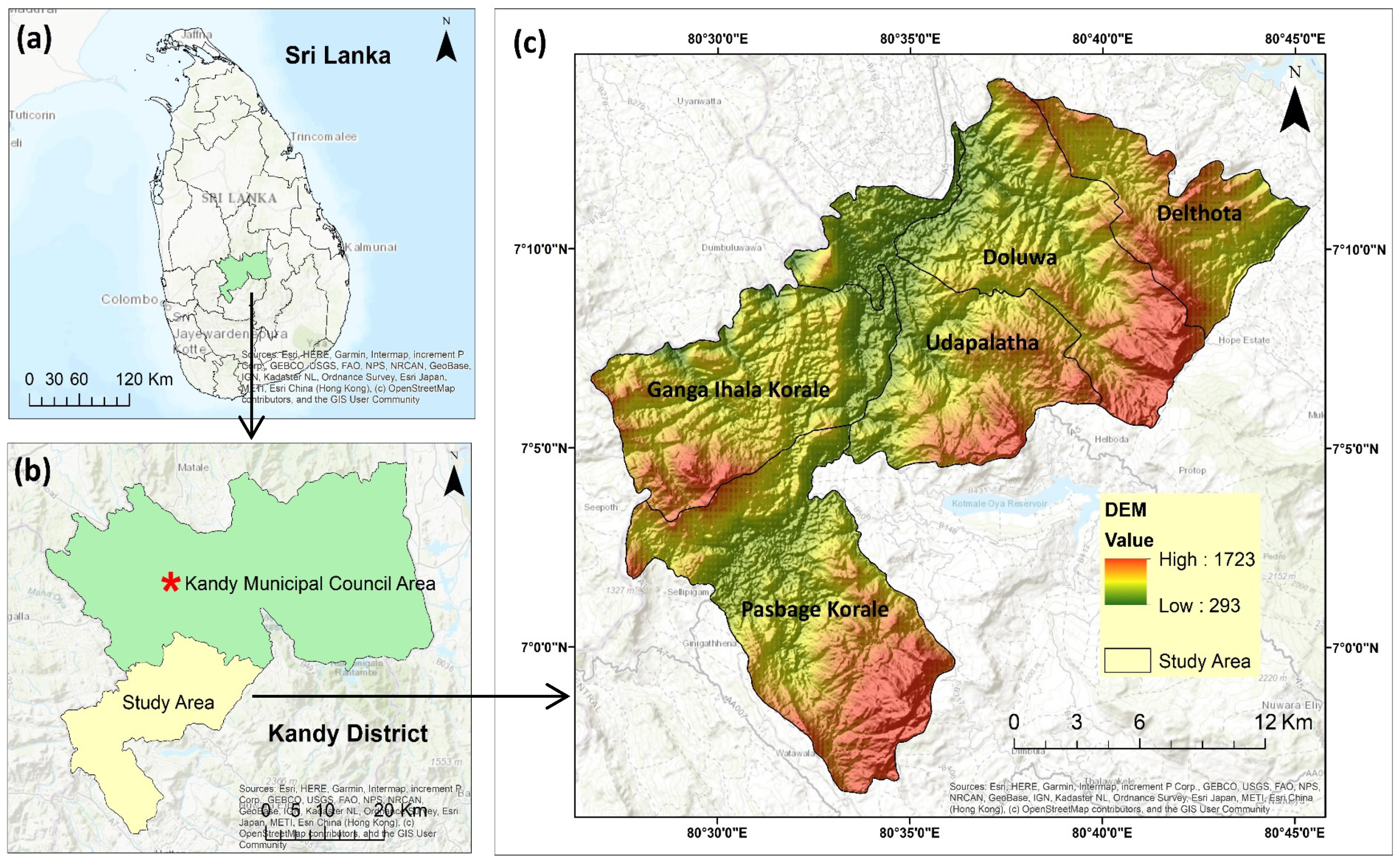
2.1. Study Area
2.2. Data Collection
2.3. Methods
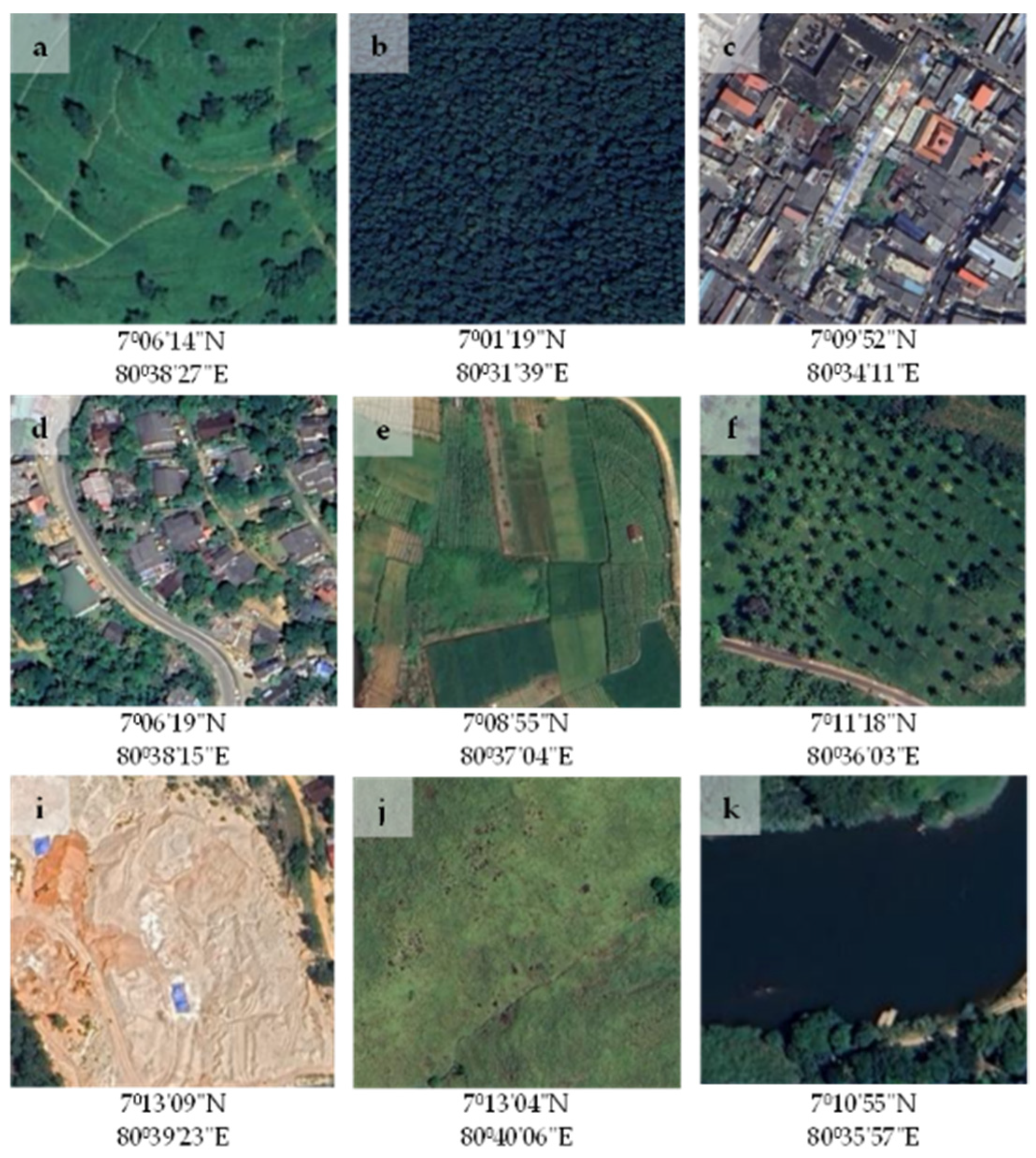
2.3.1. Define the Land Use/Cover (LULC) Classes
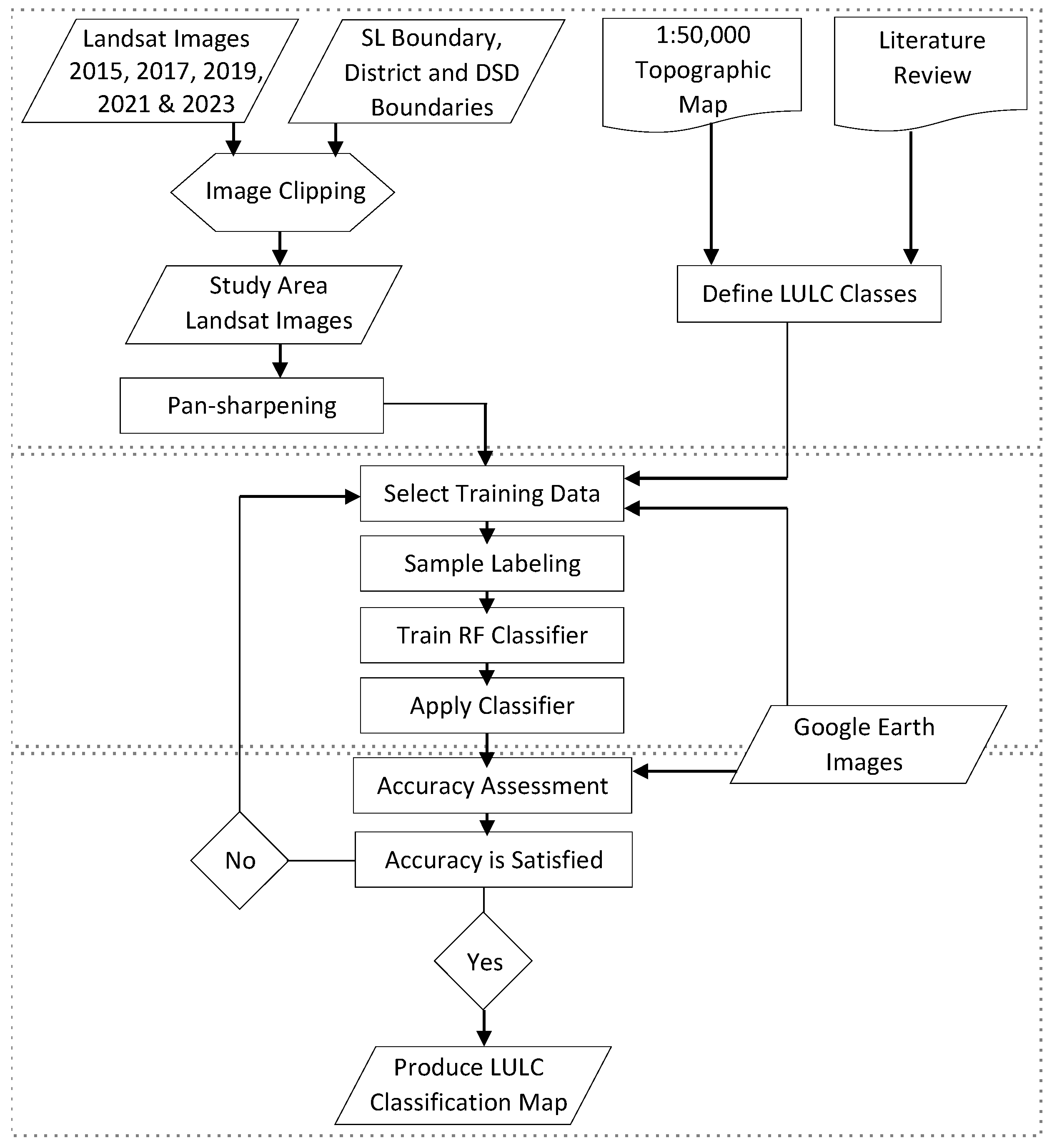
2.3.2. Image Classification Using the Random Forest Classifier
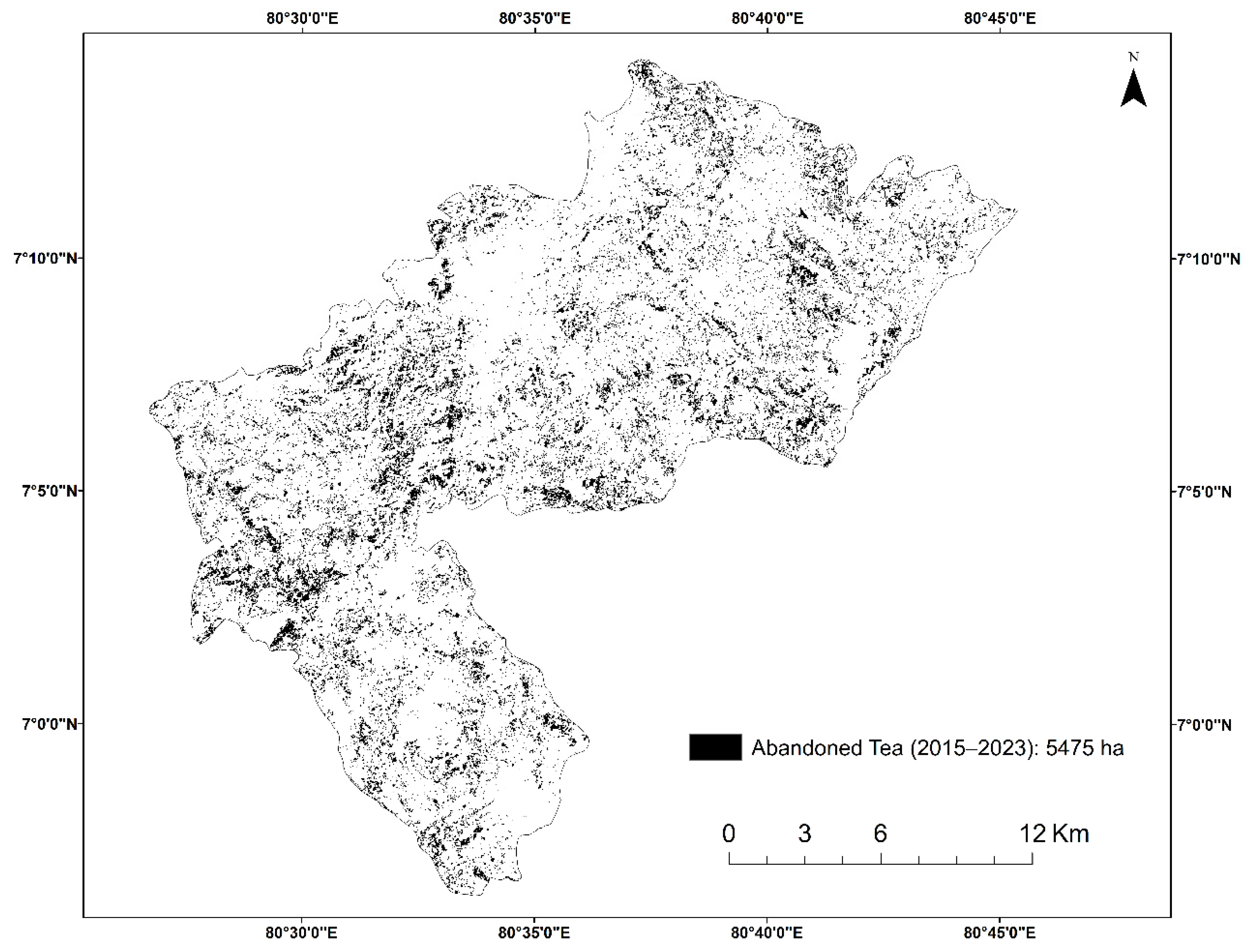
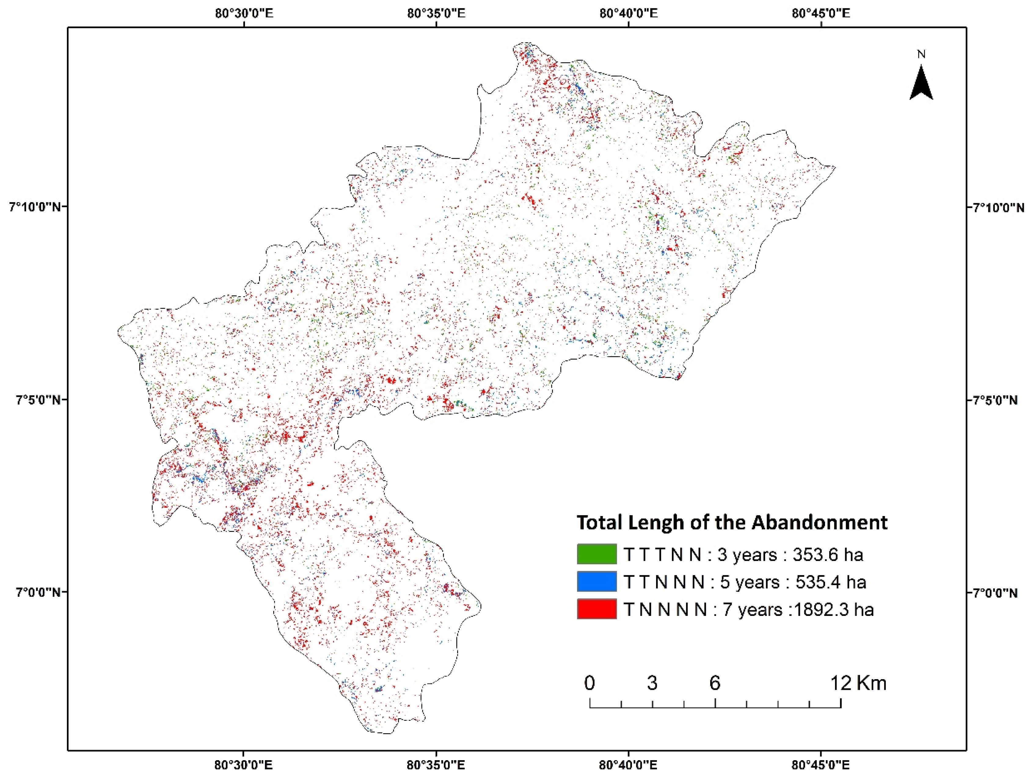
2.3.3. Identification Process of Abandoned Tea Lands
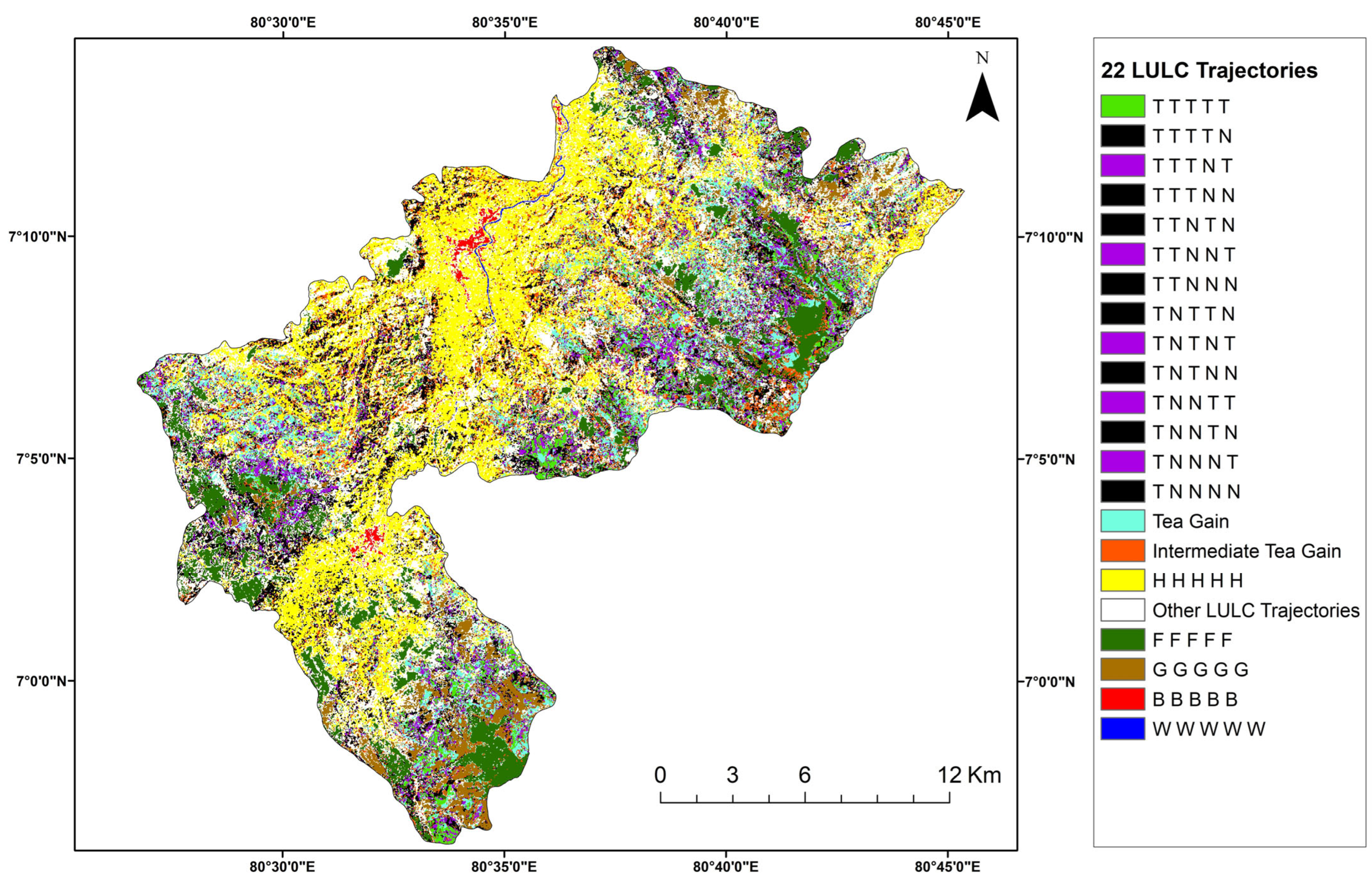
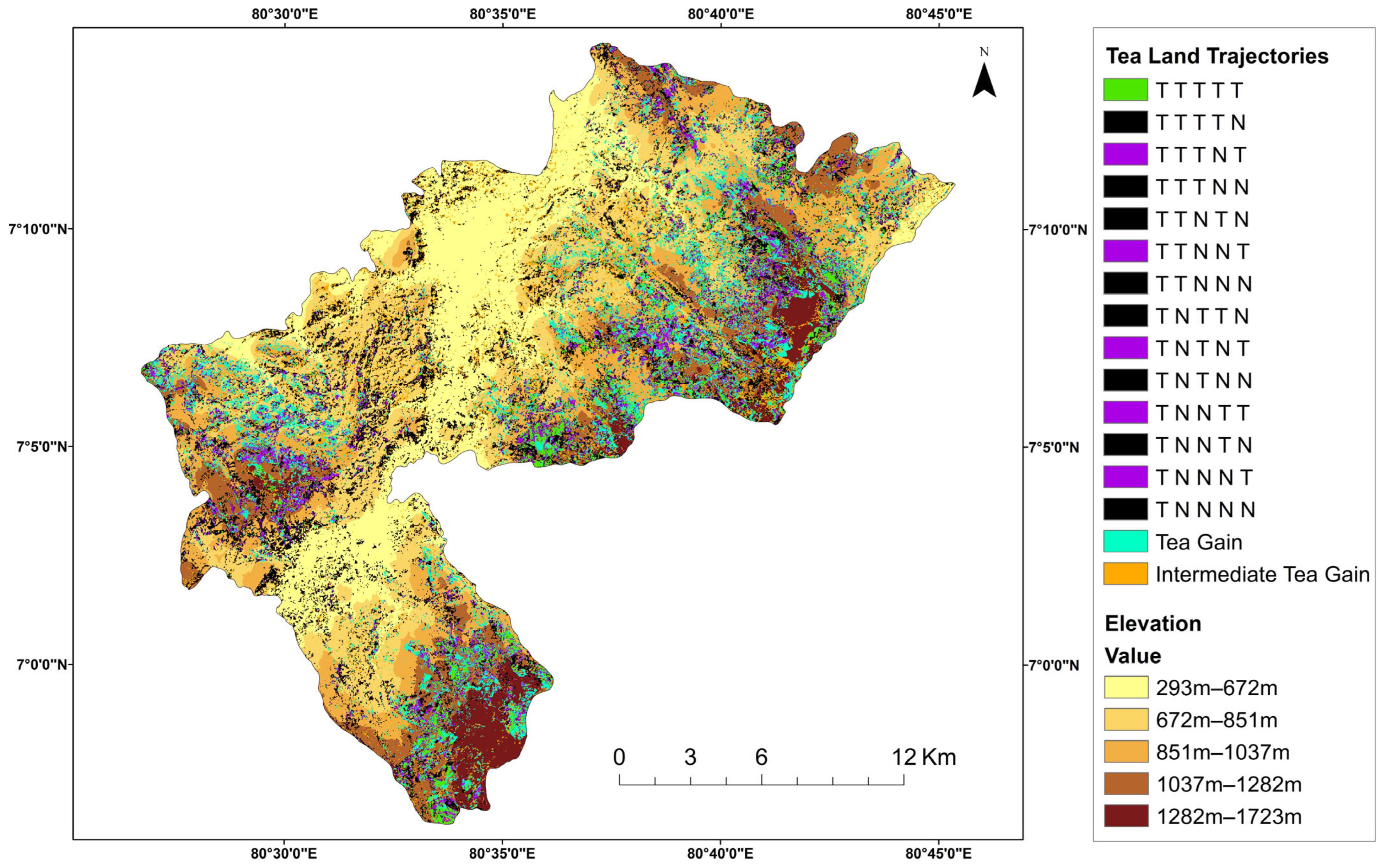
2.3.4. Land Use/Cover (LULC) Trajectory Analysis
- (a)
- Compute trajectories for the five-time period, generating a time series trajectory map.
- (b)
- Evaluate all trajectories and combine necessary trajectories based on the predefined rational rules as shown in Table 4.
| Rule # | Trajectory | Trajectory Codes | Description |
|---|---|---|---|
| Rule 1 | No change | T T T T T, H H H H H, F F F F F, and so forth | A pixel maintains the same LULC class across the five periods, it is considered to be ‘No changes.’ |
| Rule 2 | Trajectories for abandoned tea and other LULC classes | T N N N N, T T N N N, and so forth for abandoned tea | Pixels classified into LULC classes other than tea were collectively assigned the code ‘N’ (non tea). |
| T N N N T, T N N T T, and so forth for intermediate (2017–2021) abandoned tea | |||
| N T N T T, N N N N T, and so forth for tea gain | |||
| N T T T N, N T T N N, and so forth for intermediate tea gain | |||
| Rule 3 | Other trajectories | G G H H B, F F G H H, H G G W W, and so forth | Pixels classified into LULC classes other than tea throughout all five-time periods were categorized as ‘Other trajectories.’ |
2.3.5. Validation of the Results
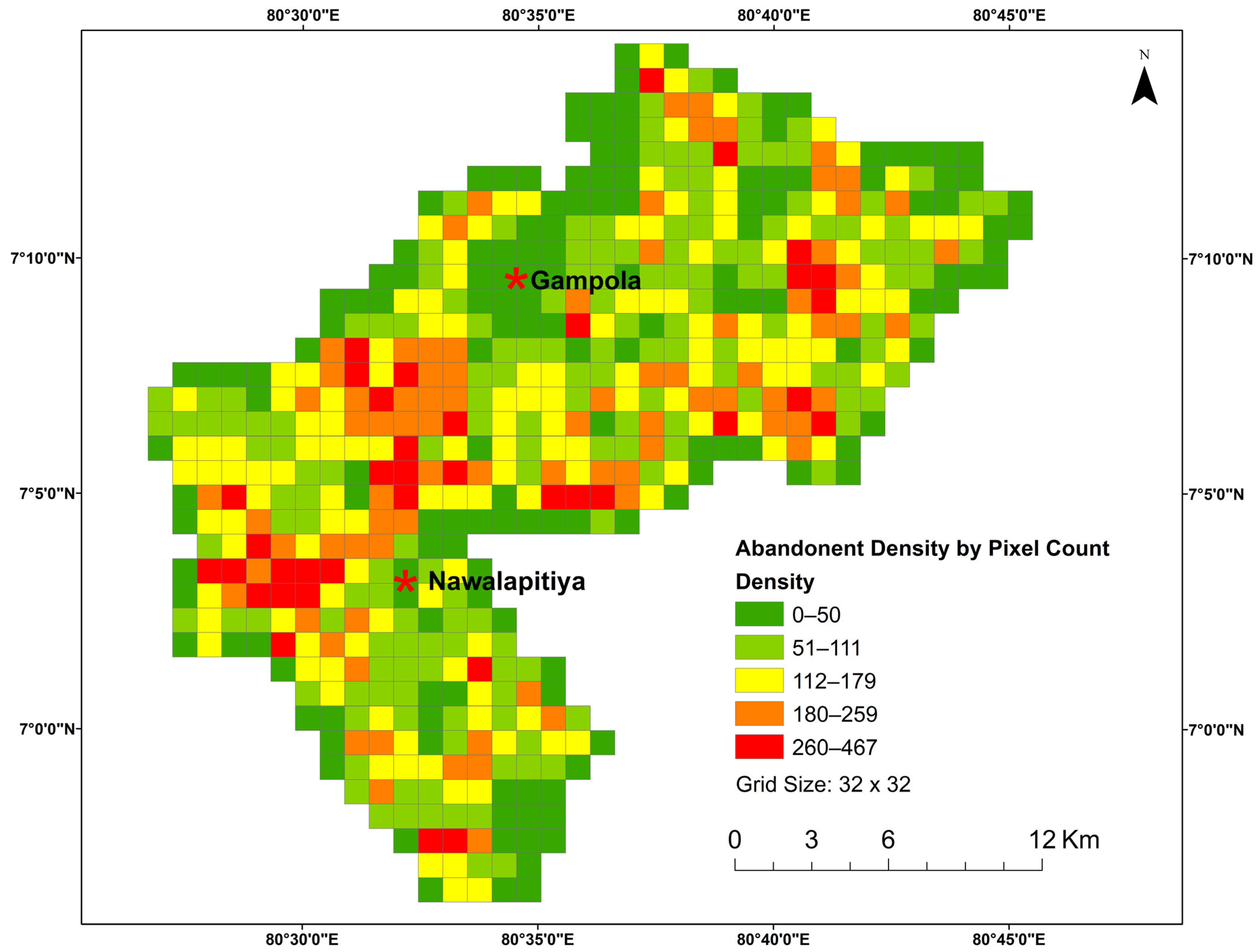
2.3.6. Grid-Based Density Analysis
3. Results and Discussion
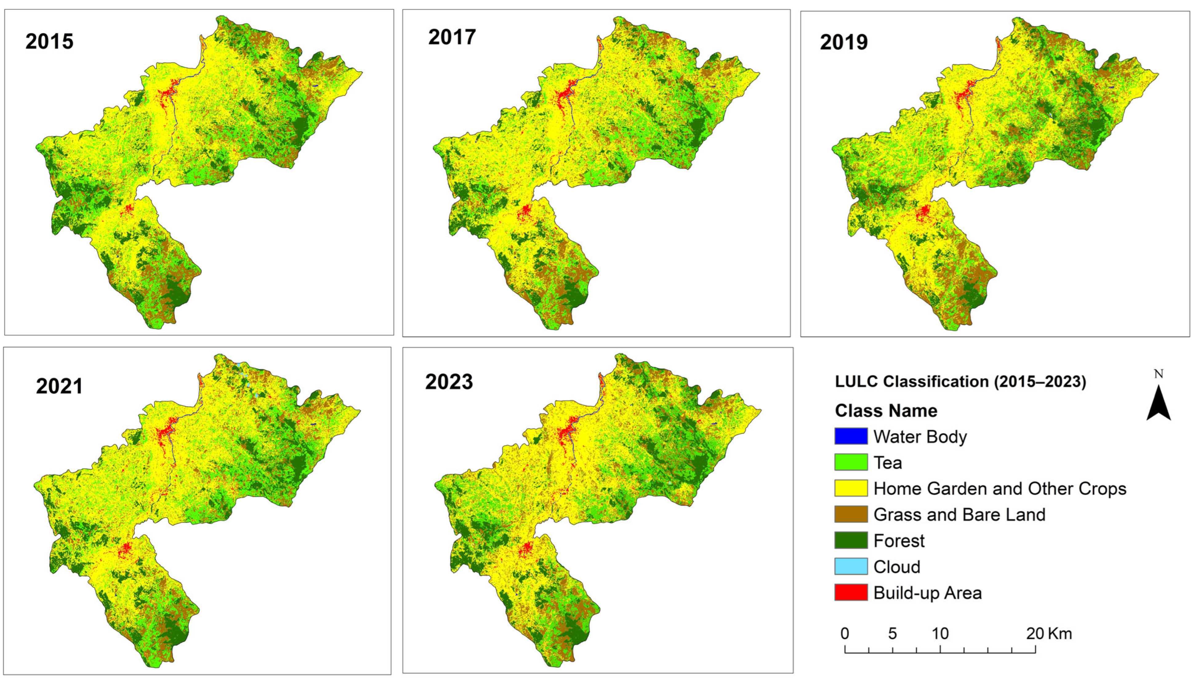
3.1. Land Use/Cover (LULC) Changes and Accuracy Assessment
3.2. Land Use/Cover (LULC) Trajectories
3.2.1. Tea Land Trajectories
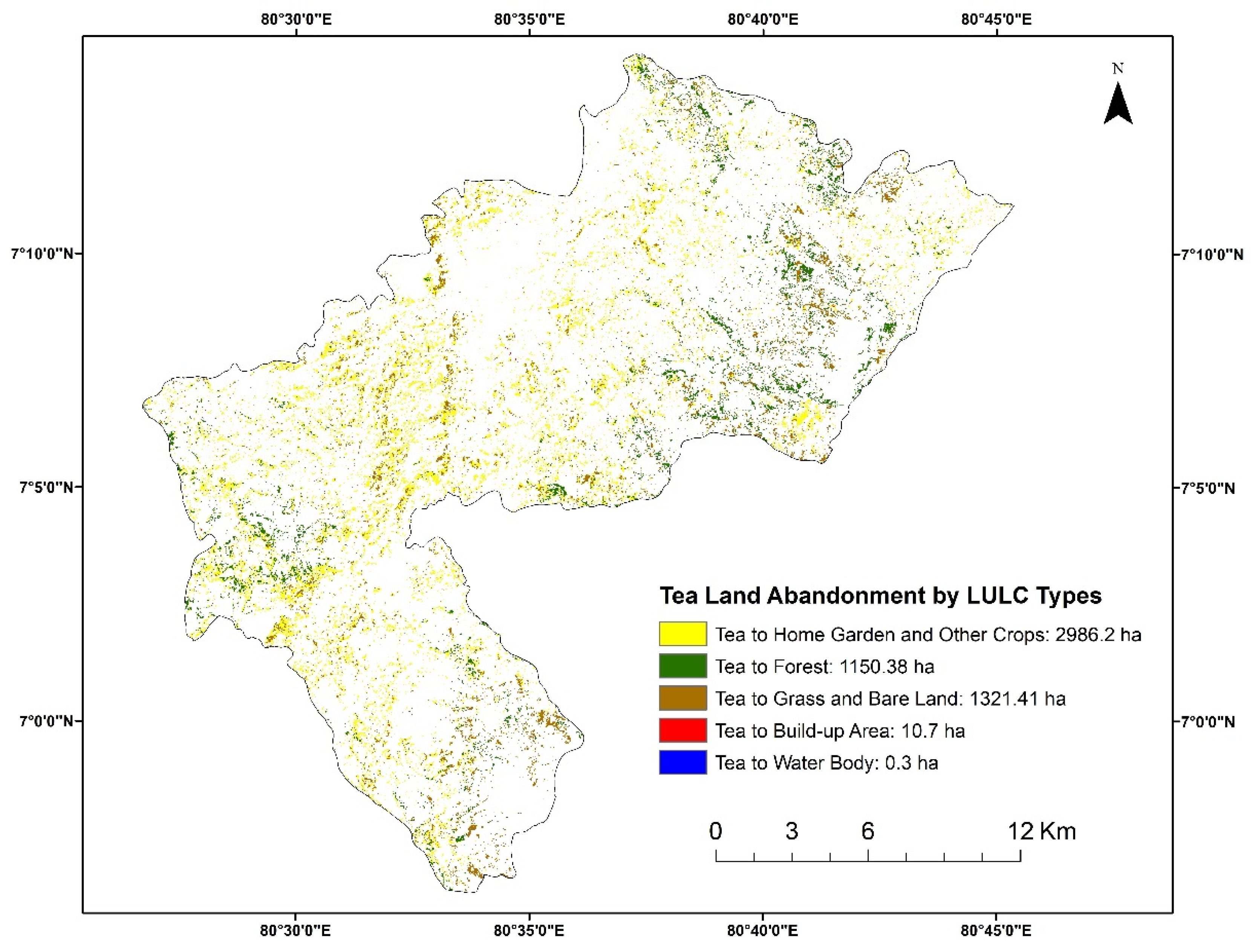
3.2.2. Spatial Distribution of Abandoned Tea Lands
4. Conclusions
Author Contributions
Funding
Data Availability Statement
Acknowledgments
Conflicts of Interest
References
- Crops and Livestock Products—FAOSTAT. Available online: https://www.fao.org/faostat/en/#data/QCL/visualize (accessed on 7 August 2025).
- Annual Report 2023. Available online: http://srilankateaboard.lk/publications/ (accessed on 7 August 2025).
- Khan, N.; Mukhtar, H. Tea and Health: Studies in Humans. Curr. Pharm. Des. 2013, 19, 6141–6147. [Google Scholar] [CrossRef] [PubMed]
- Hicks, A. Current Status and Future Development of Global Tea Production and Tea Products. Au J. Technol. 2009, 12, 251–264. [Google Scholar]
- Jayasinghe, S.L.; Kumar, L. Causes of Tea Land Dynamics in Sri Lanka between 1995 and 2030. Reg. Environ. Change 2023, 23, 127. [Google Scholar] [CrossRef]
- Hossan, M.S.; Afjal, M.I.; Hasan, M.F.; Hanif, M.A. Assessment of Land Dynamics Transformation into Tea Plantations Using Support Vector Machine. Trees For. People 2024, 18, 100703. [Google Scholar] [CrossRef]
- Wang, B.; Li, J.; Jin, X.; Xiao, H. Mapping Tea Plantations from Multi-Seasonal Landsat-8 OLI Imageries Using a Random Forest Classifier. J. Indian. Soc. Remote Sens. 2019, 47, 1315–1329. [Google Scholar] [CrossRef]
- Kottawa-Arachchi, J.D.; Ranatunga, M.A.B.; Amarakoon, A.M.T.; Gunasekare, M.T.K.; Attanayake, R.N.; Sharma, R.K.; Chaudhary, H.K.; Sood, V.K.; Katoch, R.; Banyal, D.K. Variation of Catechin and Caffeine Content in Exotic Collection of Tea [Camellia sinensis (L.) O. Kuntze] in Sri Lanka and Potential Implication in Breeding Cultivars with Enhanced Quality and Medicinal Properties. Food Chem. Adv. 2022, 1, 100108. [Google Scholar] [CrossRef]
- Ceylon Tea Industry Capability Report. Available online: https://www.srilankabusiness.com/ebooks/industry-capability-report-tea-2021.pdf (accessed on 29 November 2024).
- Ceylon Tea Export Performance in Sri Lanka—EDB Sri Lanka. Available online: https://www.srilankabusiness.com/tea/about-tea/export-performance.html (accessed on 7 August 2025).
- Herath, S.; Sugiyama, M.; Sugiyama, K.; Arahata, K. Consequence of the Policy Changes on the Plantation Agriculture A Case Study of the Sri Lanka Tea Industry (STI). Jpn. J. Farm Manag. 1998, 36, 137–142. [Google Scholar]
- Annual Report 2021. Available online: https://www.srilankateaboard.lk/wp-content/uploads/2023/09/Annual-report-2021.pdf (accessed on 29 November 2024).
- Industry Facts—EDB Sri Lanka. Available online: https://www.srilankabusiness.com/tea/ (accessed on 7 August 2025).
- Review of Tea Industry in Sri Lanka for Climate Analysis. Available online: https://www.dilmahconservation.org/pdf/review-of-tea-industry-in-sl.pdf (accessed on 17 December 2024).
- Parida, B.R.; Mahato, T.; Ghosh, S. Monitoring Tea Plantations during 1990–2022 Using Multi-Temporal Satellite Data in Assam (India). Trop. Ecol. 2024, 65, 387–398. [Google Scholar] [CrossRef]
- Prokop, P. Tea Plantations as a Driving Force of Long-Term Land Use and Population Changes in the Eastern Himalayan Piedmont. Land Use Policy 2018, 77, 51–62. [Google Scholar] [CrossRef]
- Das, A.C.; Noguchi, R.; Ahamed, T. Integrating an Expert System, GIS, and Satellite Remote Sensing to Evaluate Land Suitability for Sustainable Tea Production in Bangladesh. Remote Sens. 2020, 12, 4136. [Google Scholar] [CrossRef]
- Rahaman, S.A.; Aruchamy, S. Land Suitability Evaluation of Tea (Camellia sinensis L.) Plantation in Kallar Watershed of Nilgiri Bioreserve, India. Geographies 2022, 2, 701–723. [Google Scholar] [CrossRef]
- Tanui, J.K. Socio-Economic Constraints to Adoption of Yield Improving Tea Farming Technologies: A Study of Small Holder Tea Farmers Affiliated to Estates in Nandi Hills, Kenya. Afr. J. Agric. Res. 2012, 7, 2560–2568. [Google Scholar] [CrossRef]
- Dutta, R.; Stein, A.; Smaling, E.M.A.; Bhagat, R.M.; Hazarika, M. Effects of Plant Age and Environmental and Management Factors on Tea Yield in Northeast India. Agron. J. 2010, 102, 1290–1301. [Google Scholar] [CrossRef]
- Hajiboland, R. Environmental and Nutritional Requirements for Tea Cultivation. Folia Hortic. 2017, 29, 199–220. [Google Scholar] [CrossRef]
- Jayasinghe, H.; Suriyagoda, L.D.B.; Karunarathne, A.S.; Wijeratna, M.A. Modelling Shoot Growth and Yield of Ceylon Tea Cultivar TRI-2025 (Camellia sinensis (L.) O. Kuntze). J. Agric. Sci. 2018, 156, 200–214. [Google Scholar] [CrossRef]
- Jayasinghe, S.L.; Kumar, L. Potential Impact of the Current and Future Climate on the Yield, Quality, and Climate Suitability for Tea [Camellia sinensis (L.) O. Kuntze]: A Systematic Review. Agronomy 2021, 11, 619. [Google Scholar] [CrossRef]
- Jayasinghe, S.L.; Kumar, L. Modeling the Climate Suitability of Tea [Camellia sinensis (L.) O. Kuntze] in Sri Lanka in Response to Current and Future Climate Change Scenarios. Agric. For. Meteorol. 2019, 272, 102–117. [Google Scholar] [CrossRef]
- Jayasinghe, S.L.; Kumar, L. Climate Change May Imperil Tea Production in the Four Major Tea Producers According to Climate Prediction Models. Agronomy 2020, 10, 1536. [Google Scholar] [CrossRef]
- Herath, D.; Weersink, A. From Plantations to Smallholder Production: The Role of Policy in the Reorganization of the Sri Lankan Tea Sector. World Dev. 2009, 37, 1759–1772. [Google Scholar] [CrossRef]
- Ganewatta, G.; Edwards, G.W. The Sri Lanka Tea Industry: Economic Issues and Government Policies. In Proceedings of the 44th Annual Conference of Australian Agricultural and Resources Economics Society, University of Sydney, Sydney, Australia, 23–25 January 2000. [Google Scholar]
- Wickramasinghe, D.A.; Cameron, D. A Cultural Political Economy of Business Strategy in a Developing Country Context: The Case of the Sri Lankan Tea Industry; University of Queensland: Brisbane, Australia, 2004. [Google Scholar]
- Mahindapala, K.; Jayathilaka, M.; Jayawardane, L.; Kopiyawattage, K.P.P.; De Mel, M.P.M. Role and Capacity of Tea Societies in the Smallholding Sector in Sri Lanka: An Assessment Based on the Perceptions of Extension Officers. Trop. Agric. Res. 2020, 31, 43–55. [Google Scholar] [CrossRef]
- Jayasinghe, S.L.; Kumar, L.; Hasan, M.K. Relationship between Environmental Covariates and Ceylon Tea Cultivation in Sri Lanka. Agronomy 2020, 10, 476. [Google Scholar] [CrossRef]
- Palihakkara, I.R.; Mohammed, A.J.; Inoue, M. Current Livelihood Condition of and Futurity of Tea Farming for Marginal Small Tea Farm Holders (MSTH) of Sri Lanka: Case Study from Badulla and Matara District. Environ. Nat. Resour. Res. 2015, 5, 11–21. [Google Scholar] [CrossRef]
- Fernando, T.; Gunawardena, A. Determination of Convertion of Tea Lands in Kandy District Using Different Remote Sensing Indices. In Proceedings of the Asian Conference on Remote Sensing (ACRS), Colombo, Sri Lanka, 17–21 October 2016; pp. 17–21. [Google Scholar]
- Atzberger, C. Advances in Remote Sensing of Agriculture: Context Description, Existing Operational Monitoring Systems and Major Information Needs. Remote Sens. 2013, 5, 949–981. [Google Scholar] [CrossRef]
- Löw, F.; Fliemann, E.; Abdullaev, I.; Conrad, C.; Lamers, J.P. Mapping Abandoned Agricultural Land in Kyzyl-Orda, Kazakhstan Using Satellite Remote Sensing. Appl. Geogr. 2015, 62, 377–390. [Google Scholar] [CrossRef]
- Wang, Y.; Song, W. Mapping Abandoned Cropland Changes in the Hilly and Gully Region of the Loess Plateau in China. Land 2021, 10, 1341. [Google Scholar] [CrossRef]
- Song, W. Mapping Cropland Abandonment in Mountainous Areas Using an Annual Land-Use Trajectory Approach. Sustainability 2019, 11, 5951. [Google Scholar] [CrossRef]
- Wang, D.; Gong, J.; Chen, L.; Zhang, L.; Song, Y.; Yue, Y. Spatio-Temporal Pattern Analysis of Land Use/Cover Change Trajectories in Xihe Watershed. Int. J. Appl. Earth Obs. Geoinf. 2012, 14, 12–21. [Google Scholar] [CrossRef]
- Yang, D.; Song, W. Tracking Land Use Trajectory to Map Abandoned Farmland in Mountainous Area. Ecol. Inform. 2023, 75, 102103. [Google Scholar] [CrossRef]
- Zomlot, Z.; Verbeiren, B.; Huysmans, M.; Batelaan, O. Trajectory Analysis of Land Use and Land Cover Maps to Improve Spatial–Temporal Patterns, and Impact Assessment on Groundwater Recharge. J. Hydrol. 2017, 554, 558–569. [Google Scholar] [CrossRef]
- Mena, C.F. Trajectories of Land-Use and Land-Cover in the Northern Ecuadorian Amazon. Photogramm. Eng. Remote Sens. 2008, 74, 737–751. [Google Scholar] [CrossRef]
- Dara, A.; Baumann, M.; Kuemmerle, T.; Pflugmacher, D.; Rabe, A.; Griffiths, P.; Hölzel, N.; Kamp, J.; Freitag, M.; Hostert, P. Mapping the Timing of Cropland Abandonment and Recultivation in Northern Kazakhstan Using Annual Landsat Time Series. Remote Sens. Environ. 2018, 213, 49–60. [Google Scholar] [CrossRef]
- Xiao, Z.; Huang, X.; Zang, Z.; Yang, H. Spatio-Temporal Variation and the Driving Forces of Tea Production in China over the Last 30 Years. J. Geogr. Sci. 2018, 28, 275–290. [Google Scholar] [CrossRef]
- De Costa, W.A.; Mohotti, A.J.; Wijeratne, M.A. Ecophysiology of Tea. Braz. J. Plant Physiol. 2007, 19, 299–332. [Google Scholar] [CrossRef]
- Dharmasena, P.; Bhat, M. Economic Analysis of Multipurpose Agroforestry Plantation in Abandoned Tea Lands in Mid Country of Sri Lanka. J. Agric. Res. 2012, 50, 271–278. [Google Scholar]
- Population by DS Division and Age. 2022. Available online: http://srilankaeldercare.gov.lk/web_3/statistic.html (accessed on 20 December 2024).
- Sri Lanka Census of Population and Housing. 2011. Available online: http://203.94.94.83:8041/index.php?fileName=P1&gp=Activities&tpl=3 (accessed on 20 December 2024).
- Pareeth, S.; Karimi, P.; Shafiei, M.; De Fraiture, C. Mapping Agricultural Landuse Patterns from Time Series of Landsat 8 Using Random Forest Based Hierarchial Approach. Remote Sens. 2019, 11, 601. [Google Scholar] [CrossRef]
- Nguyen, H.T.T.; Doan, T.M.; Radeloff, V. Applying Random Forest Classification to Map Land Use/Land Cover Using Landsat 8 OLI. Int. Arch. Photogramm. Remote Sens. Spat. Inf. Sci. 2018, 42, 363–367. [Google Scholar] [CrossRef]
- Rodriguez-Galiano, V.F.; Ghimire, B.; Rogan, J.; Chica-Olmo, M.; Rigol-Sanchez, J.P. An Assessment of the Effectiveness of a Random Forest Classifier for Land-Cover Classification. ISPRS J. Photogramm. Remote Sens. 2012, 67, 93–104. [Google Scholar] [CrossRef]
- Tilahun, A.; Teferie, B. Accuracy Assessment of Land Use Land Cover Classification Using Google Earth. Am. J. Environ. Prot. 2015, 4, 193–198. [Google Scholar] [CrossRef]
- Islami, F.A.; Tarigan, S.D.; Wahjunie, E.D.; Dasanto, B.D. Accuracy Assessment of Land Use Change Analysis Using Google Earth in Sadar Watershed Mojokerto Regency. In Proceedings of the IOP Conference Series: Earth and Environmental Science; IOP Publishing: Bristol, UK, 2022; Volume 950, p. 012091. [Google Scholar]
- Nunes, A.N.; Coelho, C.O.A.; De Almeida, A.C.; Figueiredo, A. Soil Erosion and Hydrological Response to Land Abandonment in a Central Inland Area of Portugal. Land Degrad. Dev. 2010, 21, 260–273. [Google Scholar] [CrossRef]
- Estel, S.; Kuemmerle, T.; Alcántara, C.; Levers, C.; Prishchepov, A.; Hostert, P. Mapping Farmland Abandonment and Recultivation across Europe Using MODIS NDVI Time Series. Remote Sens. Environ. 2015, 163, 312–325. [Google Scholar] [CrossRef]
- Piyathissa, S.D.S.; Kahandage, P.D.; Dissanayake, P.; Rambanda, M. Selective Tea Plucking Machine to Reduce the Labor Involvement. In Proceedings of the Third International Research Symposium, Rajarata University of Sri Lanka, Anuradhapura, Sri Lanka, 26 May 2015. [Google Scholar]
- Williges, U. Status of Organic Agriculture in Sri Lanka with Special Emphasis on Tea Production Systems (Camellia sinensis (L.) O. Kuntze). Ph.D. Thesis, University of Giessen, Giessen, Germany, 2004. Available online: https://orgprints.org/id/eprint/4587/1/WilligesUte-2004-10-26.pdf (accessed on 10 August 2025).
- Myint, S.W.; Brazel, A.; Okin, G.; Buyantuyev, A. Combined Effects of Impervious Surface and Vegetation Cover on Air Temperature Variations in a Rapidly Expanding Desert City. GISci. Remote Sens. 2010, 47, 301–320. [Google Scholar] [CrossRef]
- Chen, Y.; Yang, J.; Yu, W.; Ren, J.; Xiao, X.; Xia, J.C. Relationship between Urban Spatial Form and Seasonal Land Surface Temperature under Different Grid Scales. Sustain. Cities Soc. 2023, 89, 104374. [Google Scholar] [CrossRef]
- Bagan, H.; Yamagata, Y. Land-Cover Change Analysis in 50 Global Cities by Using a Combination of Landsat Data and Analysis of Grid Cells. Environ. Res. Lett. 2014, 9, 064015. [Google Scholar] [CrossRef]
- Bagan, H.; Yamagata, Y. Landsat Analysis of Urban Growth: How Tokyo Became the World’s Largest Megacity during the Last 40 Years. Remote Sens. Environ. 2012, 127, 210–222. [Google Scholar] [CrossRef]
- Mather, P.M.; Koch, M. Computer Processing of Remotely-Sensed Images; John Wiley & Sons: Hoboken, NJ, USA, 2022; ISBN 1-119-50282-9. [Google Scholar]
- Foody, G.M. Harshness in Image Classification Accuracy Assessment. Int. J. Remote Sens. 2008, 29, 3137–3158. [Google Scholar] [CrossRef]
- Xiao, G.; Zhu, X.; Hou, C.; Xia, X. Extraction and Analysis of Abandoned Farmland: A Case Study of Qingyun and Wudi Counties in Shandong Province. J. Geogr. Sci. 2019, 29, 581–597. [Google Scholar] [CrossRef]
- Arachchi, M.A.S.M.M. Determination of Urban Heat Island Phenomena in a Small-Scale City, Based on Landsat 8 Data: A Case Study of Gampola Urban Area, Sri Lanka. J. Trop. Environ. 2022, 2, 1–17. [Google Scholar]

| Sensor | Scene ID | Acquisition Data |
|---|---|---|
| Landsat-8 OLI/TIRS (Resolution—30 m) | LC81410552015008LGN01 | 8 January 2015 |
| LC81410552017013LGN01 | 13 January 2017 | |
| LC81410552019003LGN00 | 3 January 2019 | |
| LC81410552021024LGN00 | 24 January 2021 | |
| Landsat-9 OLI/TIRS-2 (Resolution—30 m) | LC91410552023102LGN00 | 12 April 2023 |
| Image 1 | Image 2 | |
|---|---|---|
| Area of Interest | Deltota, Doluwa, Udapalatha | Ganga Ihala Koralaya, Pasbaga Koralaya |
| Sensor | Super Dove | Super Dove |
| Instrument | PSB.SD | PSB.SD |
| Acquisition Data | 9 April 2023 | 11 April 2023 |
| GSD | 3.7 m | 3.9 m |
| LULC Class | Code for Trajectory Analysis | Description | Image Reference |
|---|---|---|---|
| Tea | T | Tea land | a |
| Forest | F | Dense vegetation, forest plantation, and scrubland | b |
| Built-up Area | B | Urban residential, commercial, industrial, and transportation areas | c |
| Home Garden and Other Crops | H | Residence with some form of cultivation, paddy, and other crops | d, e, f |
| Grass and Bare Land | G | Grasslands, barren lands, and open spaces | i, j |
| Water Body | W | Natural and artificial water areas | k |
| LULC Class | 2015 | 2017 | 2019 | 2021 | 2023 | |||||
|---|---|---|---|---|---|---|---|---|---|---|
| Area (ha) | % | Area (ha) | % | Area (ha) | % | Area (ha) | % | Area (ha) | % | |
| Tea | 9818.0 | 21.6 | 7605.1 | 16.7 | 7756.5 | 17.1 | 8458.4 | 18.6 | 8446.4 | 18.6 |
| Home Garden and Other Crop | 20,986.2 | 46.2 | 23,970.2 | 52.7 | 21,676.8 | 47.7 | 23,412.0 | 51.5 | 22,156.1 | 48.7 |
| Forest | 7361.0 | 16.2 | 6789.8 | 14.9 | 6916.5 | 15.2 | 7132.7 | 15.7 | 7185.1 | 15.8 |
| Grass and Bare Land | 6805.5 | 15.0 | 6416.7 | 14.1 | 8425.0 | 18.5 | 5649.6 | 12.4 | 6834.4 | 15.0 |
| Build-up Area | 353.6 | 0.8 | 549.2 | 1.2 | 589.8 | 1.3 | 657.5 | 1.4 | 701.7 | 1.5 |
| Water Body | 143.2 | 0.3 | 141.0 | 0.3 | 103.0 | 0.2 | 110.5 | 0.2 | 126.0 | 0.3 |
| Cloud | 4.0 | 0.0 | 0.0 | 0.0 | 4.3 | 0.0 | 51.4 | 0.1 | 22.6 | 0.0 |
| Total | 45,472 | 100 | 45,472 | 100 | 45,472 | 100 | 45,472 | 100 | 45,472 | 100 |
| Other LULC | Abandoned Tea | Intermediate Tea Lost or Gain | |||||||||
|---|---|---|---|---|---|---|---|---|---|---|---|
| Trajectories | Pixel Count | Area (ha) | % | Trajectories | Pixel Count | Area (ha) | % | Trajectories | Pixel Count | Area (ha) | % |
| T T T T T | 18,630 | 1676.7 | 3.7 | T T T T N | 7252 | 652.7 | 1.4 | T T T N T | 17,500 | 1575.0 | 3.5 |
| H H H H H | 114,595 | 10,313.6 | 22.7 | T T T N N | 3929 | 353.6 | 0.8 | T T N N T | 2799 | 251.9 | 0.6 |
| F F F F F | 40,790 | 3671.1 | 8.1 | T T N N N | 5949 | 535.4 | 1.2 | T N N N T | 4194 | 377.5 | 0.8 |
| G G G GG | 22,893 | 2060.4 | 4.5 | T N N N N | 21,026 | 1892.3 | 4.2 | T N N T T | 4179 | 376.1 | 0.8 |
| B B B B B | 2901 | 261.1 | 0.6 | T N T N N | 5874 | 528.7 | 1.2 | T N T N T | 3254 | 292.9 | 0.6 |
| W W W W W | 793 | 71.4 | 0.2 | T N N T N | 6638 | 597.4 | 1.3 | Tea Gain | 43,937 | 3954.3 | 8.7 |
| Other LULC Trajectories | 125,524 | 11,297.2 | 24.8 | T T N T N | 5717 | 514.5 | 1.1 | Intermediate Tea Gain | 42,530 | 3827.7 | 8.4 |
| T N T T N | 4448 | 400.3 | 0.9 | ||||||||
| Total | 326,126 | 29,352 | 65 | Total | 60,833 | 5475 | 12 | Total | 118,393 | 10,655 | 23 |
Disclaimer/Publisher’s Note: The statements, opinions and data contained in all publications are solely those of the individual author(s) and contributor(s) and not of MDPI and/or the editor(s). MDPI and/or the editor(s) disclaim responsibility for any injury to people or property resulting from any ideas, methods, instructions or products referred to in the content. |
© 2025 by the authors. Published by MDPI on behalf of the International Society for Photogrammetry and Remote Sensing. Licensee MDPI, Basel, Switzerland. This article is an open access article distributed under the terms and conditions of the Creative Commons Attribution (CC BY) license (https://creativecommons.org/licenses/by/4.0/).
Share and Cite
Athauda, S.J.K.; Morimoto, T. Identification of Abandoned Tea Lands in Kandy District, Sri Lanka Using Trajectory Analysis and Satellite Remote Sensing. ISPRS Int. J. Geo-Inf. 2025, 14, 312. https://doi.org/10.3390/ijgi14080312
Athauda SJK, Morimoto T. Identification of Abandoned Tea Lands in Kandy District, Sri Lanka Using Trajectory Analysis and Satellite Remote Sensing. ISPRS International Journal of Geo-Information. 2025; 14(8):312. https://doi.org/10.3390/ijgi14080312
Chicago/Turabian StyleAthauda, Sirantha Jagath Kumara, and Takehiro Morimoto. 2025. "Identification of Abandoned Tea Lands in Kandy District, Sri Lanka Using Trajectory Analysis and Satellite Remote Sensing" ISPRS International Journal of Geo-Information 14, no. 8: 312. https://doi.org/10.3390/ijgi14080312
APA StyleAthauda, S. J. K., & Morimoto, T. (2025). Identification of Abandoned Tea Lands in Kandy District, Sri Lanka Using Trajectory Analysis and Satellite Remote Sensing. ISPRS International Journal of Geo-Information, 14(8), 312. https://doi.org/10.3390/ijgi14080312


