

Evaluating Real-Time and Scheduled Public Transport Data: Challenges and Opportunities


Abstract
1. Introduction
2. The Use of Real-Time Data in Transport Studies
2.1. Background
2.2. Accessibility Implications of Adopting Real-Time Data
3. Description and Characteristics of Real Time Transport Data
3.1. Sources of Data
3.2. General Transit Feed Specification (GTFS) Data
3.3. SIRI-VM Data Processing
3.4. SIRI-SX Disruption Data
3.5. GTFS-RT
4. The Application of Real-Time Travel Data
4.1. Comparative Analysis of Four Transit Data Sources
4.2. GTFS-RT Entities and Data Variation
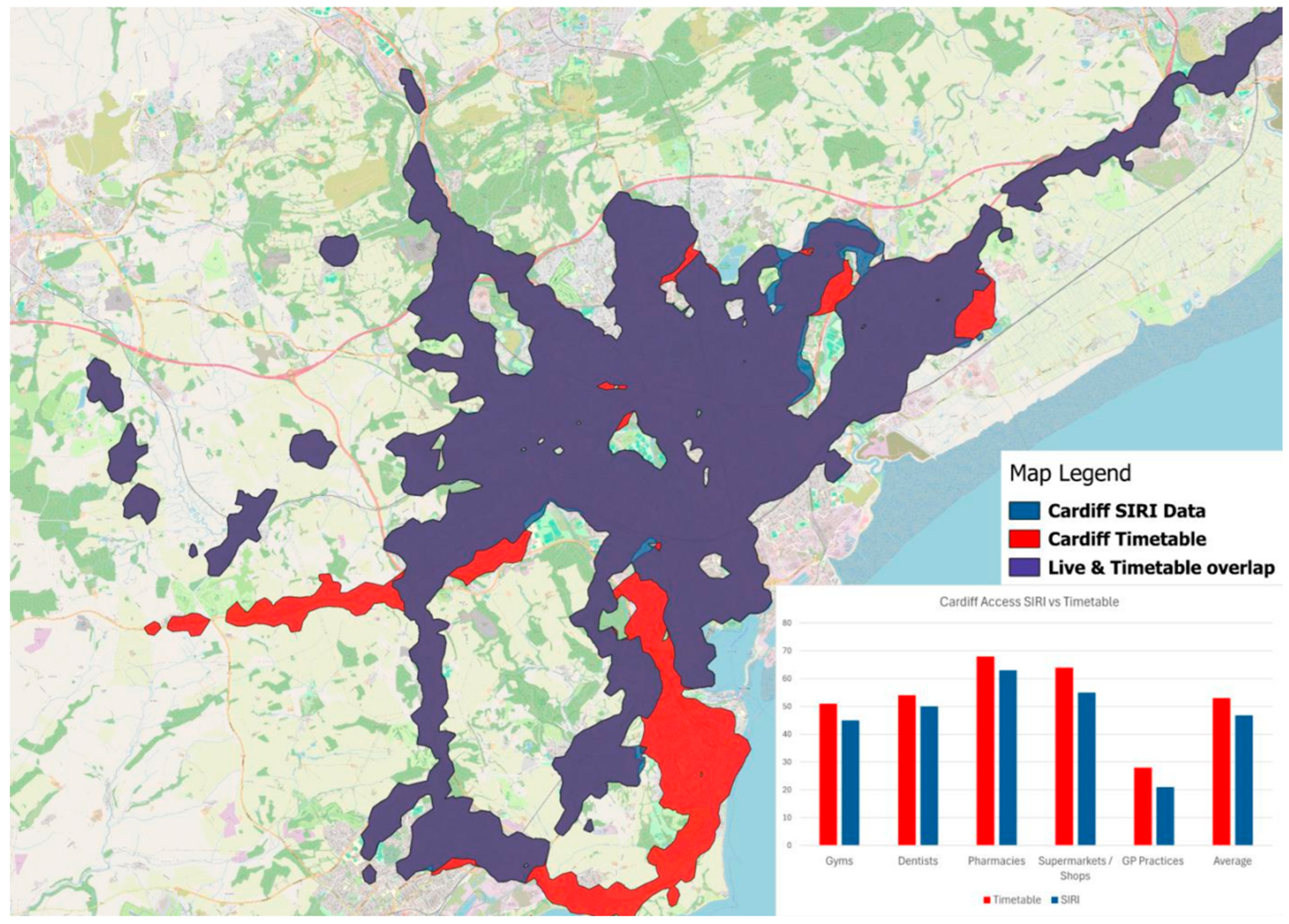
4.3. Real-Time vs. Timetable-Based Accessibility in Cardiff
4.4. Summary of Data Processing Methods and Sources
5. Discussion and Conclusions
5.1. Advantages of Using Real-Time Data in Accessibility Modelling
5.2. Limitations and Challenges
5.3. International Relevance and Transferability
5.4. Conclusion and Future Directions
Author Contributions
Funding
Data Availability Statement
Acknowledgments
Conflicts of Interest
References
- Acharya, S.; Garikapati, V.M.; Allen, M.; Lyu, M.; Hoehne, C.; Sharda, S.; Fitzgerald, R. Enriching OpenStreetMap network data for transportation applications: Insights into the impact of urban congestion on accessibility. J. Transp. Geogr. 2025, 123, 104096. [Google Scholar] [CrossRef]
- Forth, T. Transport Open Data in 2023. Available online: https://tomforth.co.uk/transportin2023/ (accessed on 17 April 2025).
- Liu, L.; Miller, H.J. Measuring risk of missing transfers in public transit systems using high-resolution schedule and real-time bus location data. Urban Stud. 2021, 58, 3140–3156. [Google Scholar] [CrossRef]
- Lovelace, R. Open-source tools for geographic analysis in transport planning. J. Geogr. Syst. 2021, 23, 547–578. [Google Scholar] [CrossRef]
- Urbano, V.M.; Arena, M.; Azzone, G. Big data for decision-making in public transport management: A comparison of different data sources. Res. Transp. Bus. Manag. 2025, 59, 101298. [Google Scholar] [CrossRef]
- Klar, B.; Lee, J.; Long, J.A.; Diab, E. The impacts of accessibility measure choice on public transit project evaluation: A comparative study of cumulative, gravity-based, and hybrid approaches. J. Transp. Geogr. 2023, 106, 103508. [Google Scholar] [CrossRef]
- Camus, R.; Longo, G.; Macorini, C. Estimation of transit reliability level-of-service based on automatic vehicle location data. Transp. Res. Rec. 2005, 1927, 277–286. [Google Scholar] [CrossRef]
- Dardas, A.; Hall, B.; Salter, J.; Hosseini, H. A geospatial workflow for the assessment of public transit system performance using near real-time data. Trans. GIS 2022, 26, 1642–1664. [Google Scholar] [CrossRef]
- de Almeida Correia, P.; Carpio-Pinedo, J.; Moya-Gómez, B.; Condeço-Mehorado, A. Modal Accessibility Gap in Curitiba (Brazil). Dynamic Analysis Considering Time and Spatial Variations. Appl. Spat. Anal. Policy 2025, 18, 34. [Google Scholar] [CrossRef]
- Kathuria, A.; Parida, M.; Chalumuri, R.S. Travel-time variability analysis of bus transit system using GPS data. J. Transp. Eng. Part A Syst. 2020, 146, 05020003. [Google Scholar] [CrossRef]
- Lee, D.; Qian, S. Using APC-AVL data to improve transit reliability and accessibility analysis. J. Transp. Eng. Part A Syst. 2024, 150, 04023127. [Google Scholar] [CrossRef]
- Ma, J.; Chan, J.; Risanoski, G.; Rajasegarar, S.; Leckie, C. Bus travel time prediction with real-time traffic information. Transp. Res. Part C 2019, 105, 536–549. [Google Scholar] [CrossRef]
- Ma, Z.-L.; Ferreira, L.; Mesbah, M.; Hojati, A.T. Modeling Bus Travel Time Reliability with Supply and Demand Data from Automatic Vehicle Location and Smart Card Systems. Transp. Res. Rec. J. Transp. Res. Board 2015, 2533, 17–27. [Google Scholar] [CrossRef]
- Bimpou, K.; Ferguson, N.S. Dynamic accessibility: Incorporating day-to-day travel time reliability into accessibility measurement. J. Transp. Geogr. 2020, 89, 102892. [Google Scholar] [CrossRef]
- Conway, M.W.; Byrd, A.; van der Linden, M. Evidence-based transit and land use sketch planning using interactive accessibility methods on combined schedule and headway-based networks. Transp. Res. Rec. 2017, 2653, 45–53. [Google Scholar] [CrossRef]
- Conway, M.W.; Byrd, A.; Van Eggermond, M. Accounting for uncertainty and variation in accessibility metrics for public transport sketch planning. J. Transp. Land Use 2018, 11, 541–558. [Google Scholar] [CrossRef]
- Wessel, N.; Farber, S. On the accuracy of schedule-based GTFS for measuring accessibility. J. Transp. Land Use 2019, 12, 475–500. [Google Scholar] [CrossRef]
- Bills, T.S.; Carrel, A.L. Transit accessibility measurement considering behavioural adaptations to reliability. Transp. Res. Rec 2021, 2675, 265–278. [Google Scholar] [CrossRef]
- Department for Transport. SIRI-VM Technical Guidance (Published 21st October 2020). Available online: https://www.gov.uk/government/publications/technical-guidance-publishing-location-data-using-the-bus-open-data-service-siri-vm/technical-guidance-siri-vm (accessed on 17 April 2025).
- Bok, J.; Kwon, Y. Comparable measures of accessibility to public transport using the General Transit Feed Specification. Sustainability 2016, 8, 224. [Google Scholar] [CrossRef]
- Prommaharaj, P.; Phithakkitnukoon, S.; Demissie, M.; Kattan, L.; Ratti, C. Visualizing public transit system operation with GTFS data: A case study of Calgary, Canada. Heliyon 2020, 6, e03729. [Google Scholar] [CrossRef]
- Viri, R.; Örmä, M. Using GTFS-data to calculate the roadwork caused delays on public transport network, World Conference on Transport Research—WCTR 2023 Montreal 17–21 July 2023. Transp. Res. Proc. 2025, 82, 1965–1973. [Google Scholar]
- Wessel, N.; Widener, M. Discovering the space-time dimensions of schedule padding and delay from GTFS and real-time transit data. J. Geogr. Syst. 2017, 19, 93–107. [Google Scholar] [CrossRef]
- Aemmer, Z.; Ranjbari, A.; MacKenzie, D. Measurement and classification of transit delays using GTFS-RT data. Public Transp. 2022, 14, 263–285. [Google Scholar] [CrossRef]
- Coghlan, C.; Dabiri, S.; Mayer, B.; Wagner, M.; Williamson, E.; Eichler, M.; Ramakrishnan, N. Assigning bus delay and predicting travel times using automated vehicle location data. Transp. Res. Rec. 2019, 2673, 624–636. [Google Scholar] [CrossRef]
- Currie, G.; Mesbah, M. Visualization of geographical information system and automatic vehicle location data to explore transit performance. Transp. Res. Rec. 2011, 2216, 59–66. [Google Scholar] [CrossRef]
- Jung, Y.-J.; Casello, J.M. Assessment of the transit ridership prediction errors using AVL/APC data. Transportation 2020, 47, 2731–2755. [Google Scholar] [CrossRef]
- Kumar, S.B.V.; Fedujwar, R.; Agarwal, A. Travel Time Variability of Bus Routes in Delhi using Real-Time GTFS Data. In Proceedings of the COMSNETS 2024: 16th International Conference on Communication Systems & Networks (COMSNETS), Bengaluru, India, 3–7 January 2024. [Google Scholar] [CrossRef]
- Li, T.; Meredith-Karam, P.; Kong, H.; Stewart, A.; Attanucci, J.P.; Zhao, J. Comparison of door-to-door transit travel time estimation using schedules, real-time vehicle arrivals, and Smartcard Inference Methods. Transp. Res. Rec. 2021, 2675, 1003–1014. [Google Scholar] [CrossRef]
- Lu, K.; Liu, J.; Zhou, X.; Han, B. A review of big data applications in urban transit systems. IEEE Trans. Intell. Transp. 2021, 22, 2535–2552. [Google Scholar] [CrossRef]
- Park, Y.; Mount, J.; Liu, L.; Xiao, N.; Miller, H.J. Assessing public transit performance using real-time data: Spatiotemporal patterns of bus operation delays in Columbus, Ohio, USA. Int. J. Geogr. Inf. Sci. 2020, 34, 367–392. [Google Scholar] [CrossRef]
- Pi, X.; Egge, M.; Whitmore, J.; Qian, Z.; Silbermann, A. Understanding Transit System Performance Using AVL-APC Data: An Analytics Platform with Case Studies for the Pittsburgh Region. J. Public Transp. 2018, 21, 19–40. [Google Scholar] [CrossRef]
- Liu, L.; Porr, A.; Miller, H.J. Measuring the impacts of disruptions on public transit accessibility and reliability. J. Transp. Geogr. 2024, 114, 103769. [Google Scholar] [CrossRef]
- Cui, M.; Levinson, D. Accessibility and the ring of unreliability. Transp. A Transp. Sci. 2018, 14, 4–21. [Google Scholar] [CrossRef]
- Lee, J.; Miller, H.J. Robust accessibility: Measuring accessibility based on travelers’ heterogeneous strategies for managing travel time uncertainty. J. Transp. Geogr. 2020, 86, 102747. [Google Scholar] [CrossRef]
- Liu, L.; Porr, A.; Miller, H.J. Realizable accessibility: Evaluating the reliability of public transit accessibility using high-resolution real-time data. J. Geogr. Syst. 2023, 25, 429–451. [Google Scholar] [CrossRef] [PubMed]
- Wessel, N.; Allen, J.; Farber, S. Constructing a routable retrospective transit timetable from a real-time vehicle location feed and GTFS. J. Transp. Geogr. 2017, 62, 92–97. [Google Scholar] [CrossRef]
- Steiner, D.; Hochmair, H.; Paulus, G. Quality assessment of open real time data for public transportation in The Netherlands. J. Geogr. Infor. Sci. 2015, 2015, 579–588. [Google Scholar]
- Van Oort, N.; Sparing, D.; Brands, T.; Goverde, R.M.P. Data driven improvements in public transport: The Dutch example. Public Transp. 2015, 7, 369–389. [Google Scholar] [CrossRef]
- Basso, F.; Frez, J.; Martinez, L.; Pezoa, R.; Varas, M. Accessibility to opportunities based on public transport gps-monitored data: The case of Santiago, Chile. Travel Behav. Soc. 2020, 21, 140–153. [Google Scholar] [CrossRef]
- Chen, B.Y.; Yuan, H.; Li, Q.; Wang, D.; Shaw, S.-L.; Chen, H.-P.; Lam, W.H.K. Measuring place-based accessibility under travel time uncertainty. Int. J. Geogr. Inf. Sci. 2017, 31, 783–804. [Google Scholar] [CrossRef]
- Nalin, A.; Fulman, N.; Wilke, E.C.; Ludwig, C.; Zipf, A.; Lantieri, C.; Vignali, V.; Simone, A. Evaluation of accessibility disparities in urban areas during disruptive events based on transit real data. Commun. Transp. Res. 2025, 5, 100160. [Google Scholar] [CrossRef]
- Braga, C.K.V.; Grangeiro, C.F.G.; Pereira, R.H.M. Evaluating the impact of public transport travel time inaccuracy and variability on socio-spatial inequalities in accessibility. J. Transp. Geogr. 2023, 109, 103590. [Google Scholar] [CrossRef]
- Nichols, A.; Ryan, J.; Palmqvist, C.-W. The importance of recurring public transport delays for accessibility and mode choice. J. Transp. Geogr. 2024, 115, 103796. [Google Scholar] [CrossRef]
- Lee, J.; Kim, J. Social equity analysis of public transit accessibility to healthcare might be erroneous when travel time uncertainty impacts are overlooked. Travel Behav. Soc. 2023, 32, 100588. [Google Scholar] [CrossRef]
- Department of Transport. Bus Open Data Service. Available online: https://www.bus-data.dft.gov.uk/ (accessed on 17 April 2025).
- Verduzco-Torres, J.R.; McArthur, D.P. Public transport accessibility indicators to urban and regional services in Great Britain. Sci. Data 2024, 11, 53. [Google Scholar] [CrossRef]
- Google Developers. GTFS Realtime Overview. Available online: https://developers.google.com/transit/gtfs-realtime (accessed on 17 April 2025).
- Google Developers. GTFS Static Overview. Available online: https://developers.google.com/transit/gtfs/ (accessed on 17 April 2025).
- Devunuri, S.; Lewis, L. A Survey of Errors in GTFS Static Feeds from the United States. Transp. Find. 2024. [Google Scholar] [CrossRef]
- General Transit Feed Specification. Available online: https://gtfs.org/documentation/realtime/feed-entities/overview/ (accessed on 17 April 2025).
- Newmark, G.L. Assessing GTFS Accuracy; San Jose University Project 2017; Mineta Transportation Institute: San Jose, CA, USA, 2024; Available online: https://transweb.sjsu.edu/sites/default/files/2017-Newmark-Public-Transit-Statistical-Analysis.pdf (accessed on 17 April 2025).
- Bergantino, A.S.; Troiani, G.; Bashir, T.; Pagliara, F. How vulnerable are road networks to shocks? An analysis through accessibility indicators. Sustain. Futures 2025, 9, 100471. [Google Scholar] [CrossRef]
- Mobility Database. Mobility Database Global Public Transit Data. Available online: https://mobilitydatabase.org/ (accessed on 3 June 2025).
- Tabascio, A.; Tiznado-Aitken, L.; Higgins, C.; Farber, S. Incorporating equity into transit performance measures: A disaggregated bus route level approach. Case Stud. Transp. Policy 2024, 17, 101256. [Google Scholar] [CrossRef]


| Field | Description | Example Value |
|---|---|---|
| ResponseTimestamp | Time when the SIRI-VM response was generated | “2025-03-17T11:54:59.253+00:00” |
| ProducerRef | Identifies the entity providing the data, such as a transport authority | “DepartmentForTransport” |
| RequestMessageRef | A unique reference ID for the data request | “eb8cd084-e479-439f-991d-9d3c7744414c” |
| ValidUntil | Indicates how long the data is valid before being refreshed | “2025-03-17T11:59:59.253+00:00” |
| ShortestPossibleCycle | Minimum time interval for updating the data | “PT5S” (5 s) |
| VehicleActivity. RecordedAtTime | Timestamp when the vehicle’s position was recorded. | “2025-03-17T11:54:22+00:00” |
| VehicleActivity. ItemIdentifier | A unique identifier for the vehicle activity event | “8eb3cb83-e692-4469-ba5e-de475a752e1c” |
| VehicleActivity. ValidUntilTime | Indicates how long this vehicle activity data remains valid | “2025-03-17T11:59:59.253+00:00” |
| MonitoredVehicleJourney. LineRef | Transit route number or identifier | “106” |
| MonitoredVehicleJourney. DirectionRef | Specifies whether the vehicle is travelling inbound or outbound | “outbound” |
| FramedVehicleJourneyRef. DataFrameRef | Date when journey is scheduled | “ 2025-03-17” |
| FramedVehicleJourneyRef. DatedVehicleJourneyRef | Unique identifier for the scheduled journey | “1130” |
| MonitoredVehicleJourney. PublishedLineName | Human-readable route name | “106” |
| MonitoredVehicleJourney. OperatorRef | Reference code for the transit operator | “A2BV” |
| MonitoredVehicleJourney. OriginRef | Reference ID for the origin stop | “2800S24007B” |
| MonitoredVehicleJourney. OriginName | Name of the origin stop | “Monk Road” |
| MonitoredVehicleJourney. DestinationRef | Reference ID for destination stop | “2800S24003E” |
| MonitoredVehicleJourney. DestinationName | Name of the destination stop | “Dominick House” |
| MonitoredVehicleJourney. OriginAimedDepartureTime | Scheduled departure time from the origin stop | “2025-03-17T11:30:00+00:00” |
| MonitoredVehicleJourney. DestinationAimedArrivalTime | Scheduled arrival time at the destination | “2025-03-17T12:12:00+00:00” |
| MonitoredVehicleJourney. VehicleLocation.Latitude | Real-time latitude coordinate of the vehicle | “53.436696” |
| MonitoredVehicleJourney. VehicleLocation.Longitude | Real-time longitude coordinate of the vehicle | “−3.056045” |
| MonitoredVehicleJourney. Bearing | Compass direction the vehicle is travelling in | “236” |
| MonitoredVehicleJourney. BlockRef | A reference to a block of trips operated by the same vehicle | “9” |
| MonitoredVehicleJourney. VehicleRef | A unique identifier for the vehicle reporting the update | “A2BV-RE24_TDZ” |
| Extensions.VehicleJourney. Operational. TicketMachineServiceCode | Service code from the ticket machine | “106” |
| Extensions.VehicleJourney. Operational.JourneyCode | Internal journey identifier used by the operator | “1151” |
| Extensions.VehicleJourney. VehicleUniqueId | A unique identifier for the vehicle across all services | “021” |
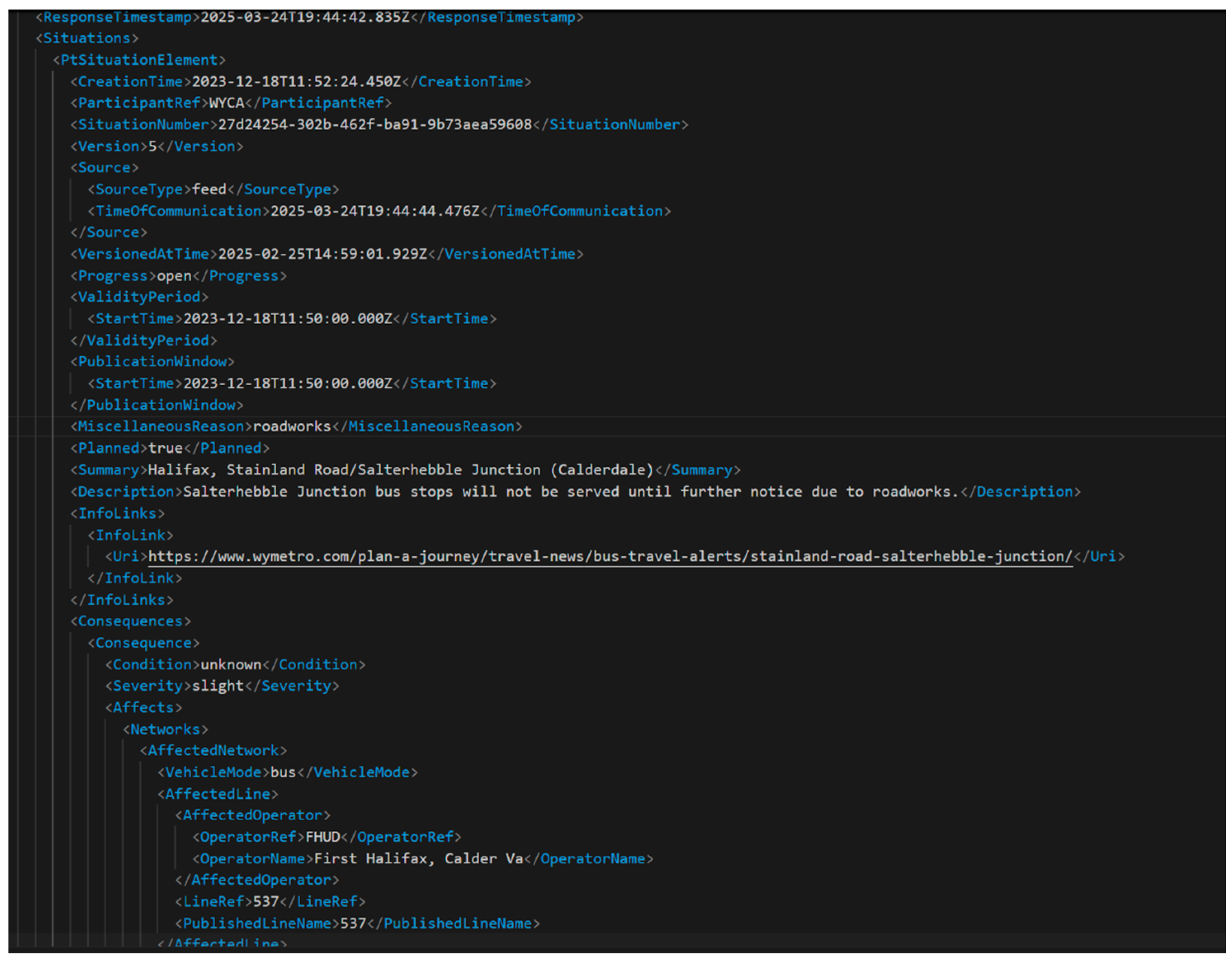
| Field | Description | Example Value |
|---|---|---|
| ResponseTimestamp | Time when the SIRI-VM response was generated | “2025-03-17T11:54:59.253+00:00” |
| ProducerRef | The entity supplying the data (e.g., the transport authority) | “DepartmentForTransport” |
| SituationNumber | A unique identifier for the disruption event | “27d24254-302b-462f-ba91-9b73aea59608” |
| CreationTime | The time when the disruption event was first created | “2023-12-18T11:52:24.450Z” |
| Version | A version number of the situation report. Updated if more details are added | “5” |
| Progress | Indicates if the situation is ongoing or resolved | “open” |
| ValidityPeriod.StartTime | Start time of the disruption | “2023-12-18T11:50:00.000Z” |
| PublicationWindow.StartTime | Time at which the disruption information was made publicly available | “2023-12-18T11:50:00.000Z” |
| MiscellaneousReason | Cause of the disruption (e.g., roadworks, accidents, etc.) | “roadworks” |
| Planned | Specifies if the disruption was planned or unplanned | “true” (for planned works) |
| Summary | A summary of the disruption | “Halifax, Stainland Road/Salterhebble Junction (Calderdale)” |
| Description | Detailed explanation of the disruption | “Salterhebble Junction bus stops will not be served until further notice due to roadworks.” |
| InfoLinks.Uri | Web link with more details about the disruption | “https://www.wymetro.com/plan-a-journey/travel-news/bus-travel-alerts/stainland-road-salterhebble-junction/” (18 June 2025) |
| Severity | Severity of the disruption (e.g., normal, slight, severe) | “slight” |
| AffectedNetwork. VehicleMode | Mode of transport affected | “bus” |
| AffectedLine.LineRef | Transit line impacted | “537” |
| AffectedOperator. OperatorRef | Operator responsible for the affected service | “FHUD” |
| AffectedStopPoint. StopPointRef | Stop ID of affected locations | “450022630” |
| AffectedStopPoint. StopPointName | Name of affected stop | “Salterhebble Junction” |
| AffectedStopPoint.Latitude | Latitude of affected stop | “53.69771827952212” |
| AffectedStopPoint.Longitude | Longitude of affected stop | “−1.85556356697551” |
| Advice.Details | Information for passengers on alternative routes or service changes | “Services 537 and X1 are using next available stops on the route—Exley Bank 45022688 and Greetland Rd Bridge 45022690” |
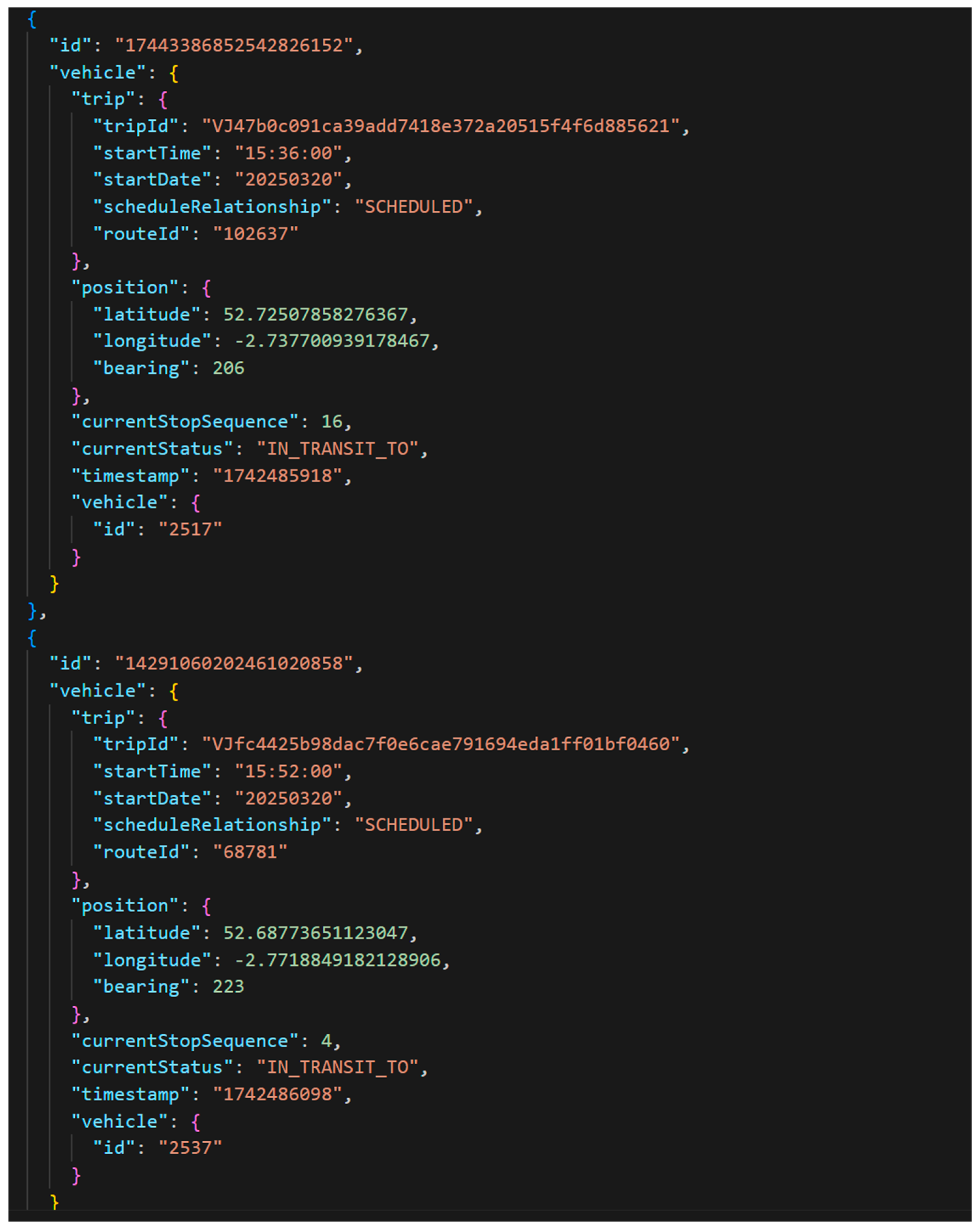
| Field | Description | Example Value |
|---|---|---|
| header.gtfsRealtimeVersion | Version of the GTFS-RT specification used | “2.0” |
| header.incrementality | Indicates whether feed contains a complete dataset or incremental updates | “FULL_DATASET” |
| header.timestamp | Unix timestamp indicating when feed was generated | “1741617828” |
| entity.id | A unique identifier for each entity (i.e., vehicle update). | “17320025737829147199” |
| entity.vehicle.trip.tripId | A unique identifier for the trip, linking real-time update to the scheduled GTFS trip data | “VJf0e21af477c8b1335584331b4fb683b205df4acb” or empty if not available |
| entity.vehicle.trip.routeId | Identifier for the transit route associated with the trip | “7428” or empty if not available |
| entity.vehicle.trip.startTime | Scheduled start time of the trip (HH:MM:SS). | “08:00:00” |
| entity.vehicle.trip.startDate | Scheduled start date of the trip (YYYYMMDD format). | “20250310” |
| entity.vehicle.trip.scheduleRelationship | Indicates if the trip is running as scheduled, or if there is a deviation (e.g., added, cancelled) | “SCHEDULED” |
| entity.vehicle.position.latitude | Real-time latitude of vehicle | “51.79374694824219” |
| entity.vehicle.position.longitude | Real-time longitude of vehicle | “−3.989114999771118” |
| entity.vehicle.currentStopSequence | Sequence number of the stop the vehicle is currently approaching or has reached | “54” |
| entity.vehicle.currentStatus | Current operational status of the vehicle | “STOPPED_AT” “IN_TRANSIT_TO” |
| entity.vehicle.timestamp | Unix timestamp for when vehicle update was recorded | “1741598993” |
| entity.vehicle.vehicle.id | Identifier for vehicle reporting the update | “FCYM-MF23ZVH” |
| Feature | GTFS | GTFS-RT | SIRI-VM | SIRI-SX |
|---|---|---|---|---|
| Nature | Static | Real-time | Real-time | Real-time |
| Format | CSV-based | Protobuf | XML | XML |
| Primary Use | Route planning, schedule-based analyses | Real-time vehicle tracking and delays | Vehicle monitoring | Disruption management |
| Adoption | Global Widely used | Widespread adoption in North America Some global usage | European transport systems | European transport systems |
| Granularity | Fixed schedule data | Updated every minute; no caching | High-resolution vehicle locations, end-of-day caching | Detailed disruption data |
| Ease of Integration | High | Moderate | Complex | Complex |
| Limitations | No real-time updates | Requires agency compliance for accuracy | Complexity in parsing Variable adoption | Dependent on agency data accuracy |
Disclaimer/Publisher’s Note: The statements, opinions and data contained in all publications are solely those of the individual author(s) and contributor(s) and not of MDPI and/or the editor(s). MDPI and/or the editor(s) disclaim responsibility for any injury to people or property resulting from any ideas, methods, instructions or products referred to in the content. |
© 2025 by the authors. Published by MDPI on behalf of the International Society for Photogrammetry and Remote Sensing. Licensee MDPI, Basel, Switzerland. This article is an open access article distributed under the terms and conditions of the Creative Commons Attribution (CC BY) license (https://creativecommons.org/licenses/by/4.0/).
Share and Cite
Webb, L.; Higgs, G.; Langford, M.; Berry, R. Evaluating Real-Time and Scheduled Public Transport Data: Challenges and Opportunities. ISPRS Int. J. Geo-Inf. 2025, 14, 243. https://doi.org/10.3390/ijgi14070243
Webb L, Higgs G, Langford M, Berry R. Evaluating Real-Time and Scheduled Public Transport Data: Challenges and Opportunities. ISPRS International Journal of Geo-Information. 2025; 14(7):243. https://doi.org/10.3390/ijgi14070243
Chicago/Turabian StyleWebb, Liam, Gary Higgs, Mitchel Langford, and Robert Berry. 2025. "Evaluating Real-Time and Scheduled Public Transport Data: Challenges and Opportunities" ISPRS International Journal of Geo-Information 14, no. 7: 243. https://doi.org/10.3390/ijgi14070243
APA StyleWebb, L., Higgs, G., Langford, M., & Berry, R. (2025). Evaluating Real-Time and Scheduled Public Transport Data: Challenges and Opportunities. ISPRS International Journal of Geo-Information, 14(7), 243. https://doi.org/10.3390/ijgi14070243