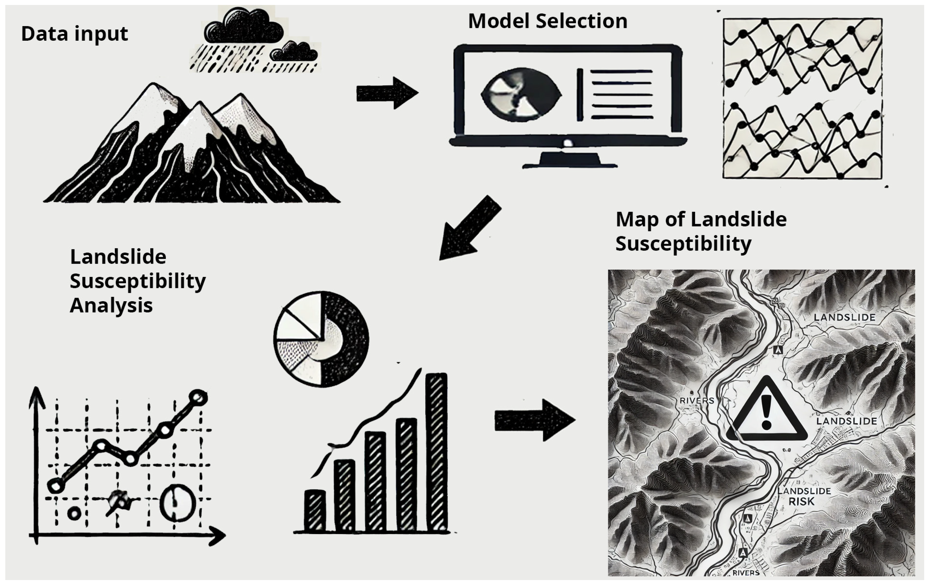
1. Introduction
Landslide susceptibility indicates the likelihood that a particular area will experience landslides or soil slippage. This susceptibility is shaped by various factors, including geological, environmental, and human-related influences [
1]. Landslide susceptibility depends on factors such as topography (steep slopes), soil type (clayey/silty), and intense rainfall, which saturates the soil. These factors increase the risk of landslides and mudflows [
2,
3,
4]. Human activities (like construction or deforestation) and past landslides increase regional vulnerability [
1,
3]. Risk assessment, through geotechnical and hydrological analyses, allows the identification of critical areas and the planning of interventions (engineering structures, soil stabilization, or monitoring) [
5,
6]. Natural disasters such as landslides, cause fatalities, but preventive measures and rapid responses can reduce them. Landslide hazard refers to the potential for slope failure, while risk quantifies the resulting economic and human losses [
5]. Landslides are the result of a combination of natural factors (like heavy rainfall or floods) and human factors (like land use changes or deforestation) [
7,
8]. The interaction between rain, surface runoff, and subsurface runoff destabilizes slopes by eroding materials and modifying the regolith. Deforestation, hill cutting, and inadequate rural land planning, which represent forms of poor land management, are primary causes that exacerbate triggering factors and increase landslide risk [
9,
10]. According to the United Nations Office for Disaster Risk Reduction (UNDRR), landslides accounted for approximately 5% of all natural disaster-related deaths between 1998 and 2017, with over 18,000 fatalities globally [
11]. Natural disasters in 2016 caused 8733 deaths and
$154 billion in damages, highlighting the devastating socio-economic impact of these events [
11]. Italy is among the most vulnerable European countries in this regard, with 620,808 landslides affecting 23,700 km
2, or 7.9% of its national territory [
12,
13,
14]. Vegetation cover plays a crucial role in reducing hydrogeological risks, preventing runoff and surface erosion, and increasing soil shear resistance through root systems [
5,
15]. One of the key approaches for developing risk reduction strategies is the creation of a landslide susceptibility map (LSM). An LSM offers a spatial distribution of potential landslides, thus playing an essential role in mitigating landslide risk [
16]. Models estimate risks and generate probability maps under various forest management and rainfall scenarios. Models for predicting landslide susceptibility are crucial tools for managing and mitigating natural risks [
5]. These models help identify areas potentially prone to landslides, allowing planners and decision-makers to take preventive measures and reducing the impact of such events on people, infrastructure, and the environment [
17]. Various methods for generating landslide susceptibility maps have been demonstrated over the past decades [
5,
15,
18,
19,
20]. Landslide susceptibility mapping models offer several benefits, such as risk prevention and mitigation by identifying at-risk areas for planning interventions, emergency management by locating hazardous areas during critical events, land planning by supporting urban development and environmental conservation, and environmental monitoring by assessing the impact of climatic and environmental changes. Many researchers have explored different approaches for creating LSMs. In addition to crisis management, LSMs are crucial for identifying areas at risk of landslides, as well as for managing and reducing such risks [
21]. These maps can be generated using an appropriate model, incorporating landslide data and a set of independent variables [
22]. There are three main groups of landslide susceptibility methods: innovative, deterministic, and statistical [
23]. Innovative models rely on expert judgment to assign weights to each factor. Therefore, this type of model has a higher potential for errors [
24]. Deterministic models are developed based on mathematical relationships. These models are grounded in physical laws, requiring the calculation of the relationship between resisting forces and the drivers of mass movements [
25].
4SLIDE is a physical model based on a deterministic approach, used to simulate slope stability and predict susceptibility to shallow landslides [
19]. The 4SLIDE model integrates geological, topographical, and hydrological parameters to estimate a Factor of Safety (FS) index, indicating the stability of a location (0 represents the most unstable state, while 1.5 represents the most stable state). SHALSTAB (Shallow Landsliding Stability Model) is another widely used physical-deterministic model for predicting shallow landslides. It relies on analyzing slope stability alongside a hydrological model to assess soil saturation levels from rainfall and the potential for shallow landslides [
26]. Both SHALSTAB and 4SLIDE are powerful tools in landslide risk management, each suited to specific contexts (
Figure 1). SHALSTAB is ideal for large-scale analyses, especially in high-rainfall regions, where it predicts risk effectively over broad areas. In contrast, 4SLIDE is tailored for detailed site-specific analysis, especially in locations where soil characteristics are crucial to understanding risk. Both models utilize numerical geotechnical parameters distributed spatially within a raster-based GIS framework. However, their integration enables a more comprehensive and detailed understanding of the dynamics of landslide susceptibility. Comparing landslide susceptibility models not only helps assess the robustness and reliability of predictions but also identifies differences and similarities between the two approaches, thereby enhancing the accuracy of risk estimates. This dual analysis allows for the combination of the strengths of both models, enabling the identification of the most appropriate one for specific scenarios and, in some cases, suggesting their integrated use.
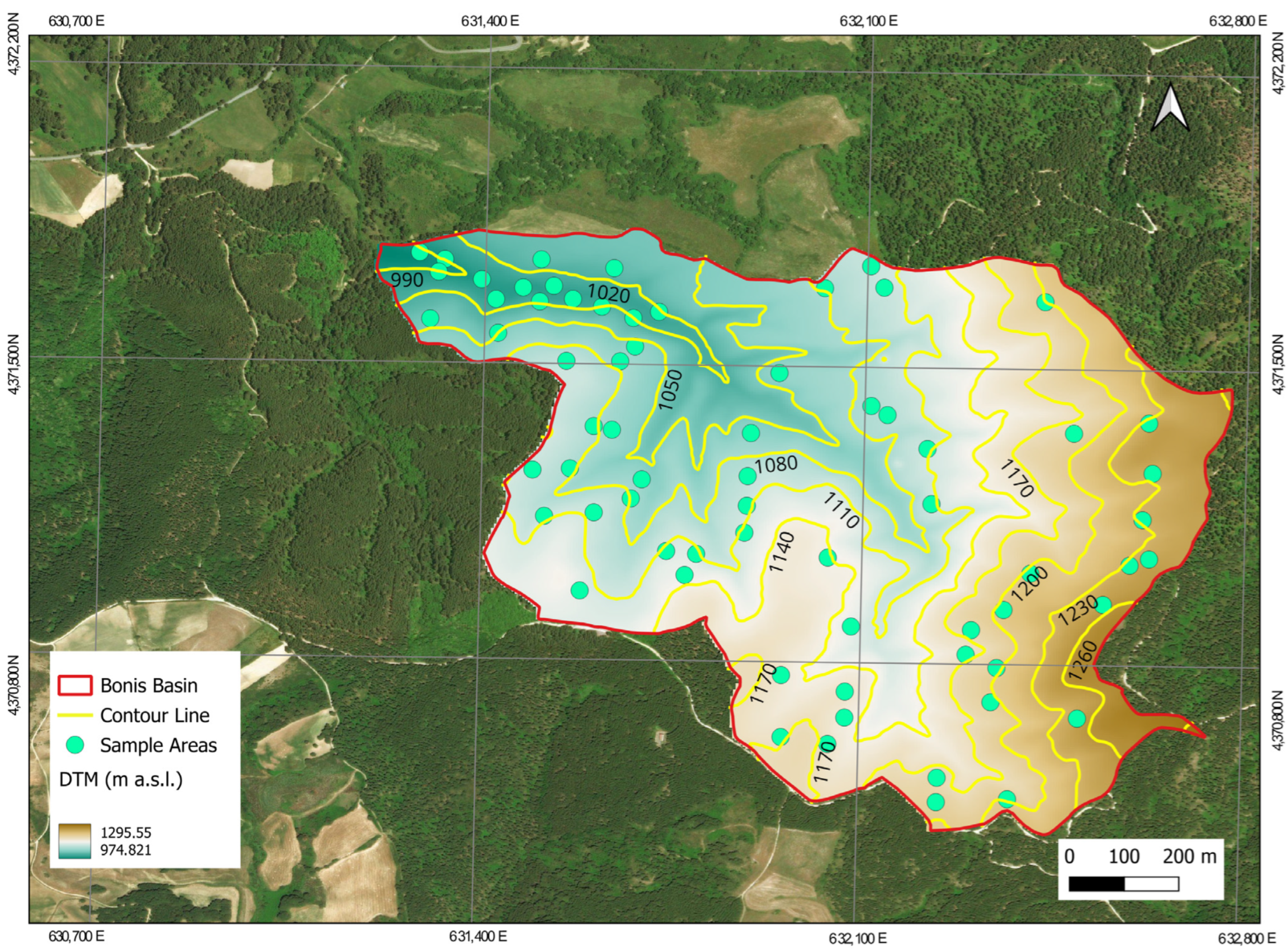
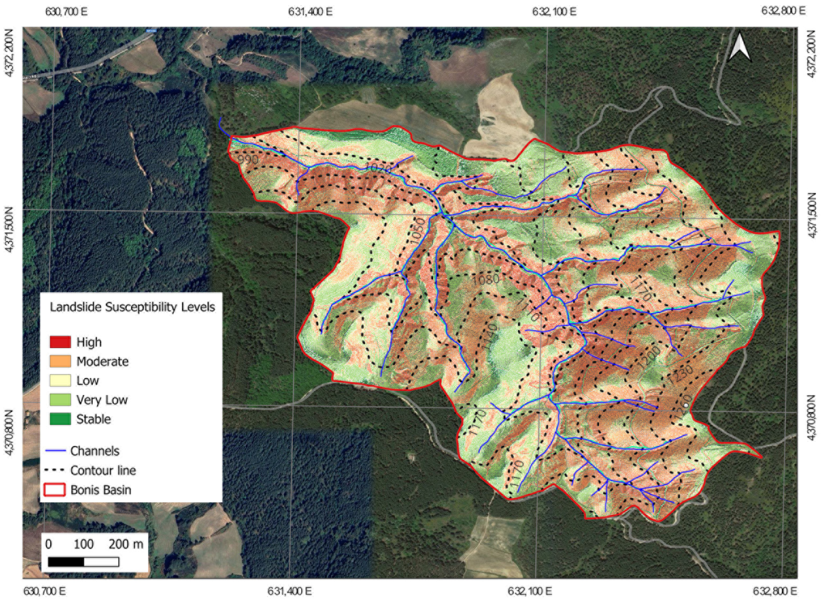
This study compares the 4SLIDE model with another landslide susceptibility mapping model, SHALSTAB, highlighting the innovation of an in-depth comparative analysis based on the combined use of two distinct modeling approaches. For a comparative analysis of the different parameter percentages in landslide-prone areas, such as susceptibility assessments provided by models like 4SLIDE or SHALSTAB, it is useful to examine the distribution of various risk categories (e.g., low, medium, and high) over a specific map or region. This approach may include comparing the percentages of different risk levels or analyzing variations in a key parameter, such as terrain slope or soil saturation, within distinct risk zones. The novelty of the study lies in the direct comparison between the two models, which represent complementary but distinct methodologies. Focusing on detailed geotechnical analysis, 4SLIDE considers physical parameters of the terrain, such as slope stability and sliding phenomena, with high local resolution. On the other hand, SHALSTAB adopts a more generalized hydrological approach, based on hydrological thresholds and a broader scale of analysis, suitable for estimating risk areas in regional contexts. This process represents a methodological innovation that not only supports decision-making in risk management and landslide prevention planning but also makes a significant contribution to improving the practical applicability and reliability of existing models, ensuring more effective and sustainable land management. The comparison of the two models was conducted in data from the Bonis catchment, an experimental forested area in Calabria, southern Italy, which serves as an ideal research site for studying hydrology, meteorology, and forestry in a Mediterranean mountain environment. This catchment features varied topography, including steep slopes, diverse soil types, and vegetation. Thus, it reflects the complexities of landslide-prone regions. Equipped with an advanced monitoring network, the Bonis catchment tracks geotechnical and hydrological parameters, such as surface runoff, groundwater levels, soil moisture, and precipitation, providing high-resolution data essential for model calibration and validation [
27]. The catchment’s small size and consistent land use minimize external influences, offering a controlled environment for focused analysis of landslide susceptibility factors like soil properties, slope stability, and hydrology. Overall, the Bonis catchment is a representative site for evaluating landslide susceptibility models in Mediterranean mountain regions, making it an ideal location for this comparative study [
27].
3. Results
The results from the two methodologies used to assess landslide susceptibility led to the creation of a susceptibility index, highlighting areas that are at risk. Each pixel on the generated maps corresponds to a Factor of Safety (FS) value, which categorizes the landslide susceptibility of various regions. The analysis highlighted a clear correlation between higher susceptibility areas and steep slope regions, particularly those with established river networks, underscoring the critical role that slope plays in evaluating landslide risk. The maps produced by both models allow for the classification of five classes based on the FS values. For the 4SLIDE model, the analysis revealed that 15% of the study area was classified as “high susceptibility to landslides”. The Factor of Safety (FS) value ranged between 0.0 and 0.5, indicating a high probability of landslide occurrence. In contrast, 36% of the area showed medium susceptibility, with FS values between 0.5 and 1.3, suggesting a moderate risk of landslides. Additionally, 20% of the study area was classified as having “low to very low” susceptibility to shallow landslides, with FS values between 1.3 and 1.5, indicating a relatively stable condition but still subject to a certain degree of potential instability. This indicates a relatively stable condition, although some instability potential remains (
Figure 5).
In comparison, the SHALSTAB model (
Figure 6) also identified 15% of the area as having high instability (0.0 < FS < 0.5). However, a larger portion of the area (49%) was classified as medium susceptibility (0.5 < FS < 1.3), while only 6% was classified as having low stability (1.3 < FS < 1.5).
Both models consistently identified the most vulnerable areas along steep slopes and unconsolidated geological materials, such as colluvium, particularly those in proximity to watercourses. In contrast, the more stable regions were typically located further away, upslope from these watercourses. The sensitivity analysis conducted across different slope categories further confirmed that both models exhibit varying predictive performances depending on terrain inclination. In particular, the models demonstrated higher sensitivity on steeper slopes (35–90°), where landslides were more frequent, while performance decreased on more gradual slopes (0–15°), where stable conditions prevailed. The analysis of the factor of safety (FS) across different slope classes provided further insights into the behavior of the two models. For low slopes (0–15°), both models indicated stable conditions, but 4SLIDE produced a slightly higher average FS (1.81) compared to SHALSTAB (1.67), suggesting that it considers the terrain marginally more stable. In the medium slope range (15–35°), SHALSTAB exhibited a slightly higher minimum FS value (1.03) compared to 4SLIDE (0.95), implying that it tends to classify certain areas as more stable. However, the overall average FS remained similar between the two models, with 4SLIDE at 1.74 and SHALSTAB at 1.68. The most significant differences were observed in the high slope category (35–90°), where landslides are more likely to occur. Here, SHALSTAB showed a higher minimum FS (0.97) compared to 4SLIDE (0.23), suggesting a more conservative approach to instability classification, whereas the average FS remained relatively close (1.60 for 4SLIDE and 1.65 for SHALSTAB). In evaluating the models’ performance, the Area Under the Curve (AUC) method was used. This methodology allows for the verification of the reliability of the two susceptibility models for landslide risk through two parameters: sensitivity and specificity. Sensitivity measures the models’ ability to correctly identify true positive cases (actual landslides), while specificity measures the models’ ability to correctly identify true negative cases (stable areas). These two indicators are crucial in ROC analysis for understanding a model’s ability to accurately predict susceptible or non-susceptible areas for landslides, minimizing the number of false positives and false negatives [
37,
38]. The 4SLIDE model provided AUC values of 0.76 and 0.70 (
Figure 7a)when compared with ground truth data (GTS) and the Digital Terrain Model (DTM) derived from LiDAR, respectively. Similarly, the SHALSTAB model produced AUC results of 0.73 and 0.69 for the same comparisons(
Figure 7b). These values indicate that both models demonstrate strong predictive capabilities in identifying areas susceptible to shallow landslides, with slightly better performance for the 4SLIDE model. The sensitivity analysis also revealed that while both models effectively captured landslide-prone areas on steep slopes, discrepancies were observed in lower slope categories (0–15° and 15–35°), where SHALSTAB tended to classify a slightly larger proportion of stable areas as susceptible compared to 4SLIDE. This difference may be attributed to variations in the models’ underlying assumptions regarding hydrological and geomorphological processes influencing slope stability. To further assess the agreement between the two models, Cohen’s Kappa (κ) coefficient was calculated. The results indicate a strong agreement between the 4SLIDE model and the ground truth survey (GTS) data, with a Cohen’s Kappa value of κ = 0.77, while the SHALSTAB model showed a slightly lower but still good agreement, with κ = 0.72. When compared with the DTM-LiDAR data, both models exhibited moderate agreement, with κ = 0.65 for 4SLIDE and κ = 0.66 for SHALSTAB. These values suggest that while both models perform well, 4SLIDE demonstrates slightly stronger agreement with the ground truth data (GTS) than SHALSTAB. Both models showed moderate agreement when validated with the DTM-LiDAR data.
Overall, the results show a strong correlation between the generated susceptibility maps and the landslide location recorded through field data. Both models effectively identified risk areas, although, like other predictive models, they rely on comprehensive input data to ensure high reliability. The sensitivity analysis further highlighted that the models’ predictive performance varies depending on slope gradients, with a notable decline in accuracy on gentle slopes. This study demonstrates the utility and accuracy of these methodologies in landslide susceptibility assessment, paving the way for better-informed risk management and mitigation strategies in susceptible regions.
4. Discussion
Landslides are catastrophic events that cause significant damage, ranking among the natural disasters with the highest economic impact [
9,
10,
13,
14]. This has led to a growing interest in predictive studies aimed at mitigating risks and ensuring the safety of people and property. Over the past 30 years, many authors have proposed predictive models to identify areas prone to landslides, providing valuable tools for preventive actions [
45,
46,
47,
48]. Identifying these areas is essential for effective regional management and the implementation of mitigation strategies. In this context, the 4SLIDE model is particularly useful, as it generates landslide susceptibility maps for both forested and non-forested regions, highlighting the impact of vegetation on soil stability. The model accounts for various factors, including root cohesion (which stabilizes soil through vegetation), soil properties (such as texture, cohesion, and permeability), and terrain morphology (including slope, elevation, and curvature). By integrating these parameters, 4SLIDE offers a comprehensive approach to assessing landslide risk, helping decision-makers prioritize areas for intervention and improve land-use planning in landslide-prone regions [
17].
Numerous models exist for such analyses, each with its own strengths and weaknesses in terms of ease of use, graphical interface, input parameter determination, and, in many cases, economic cost. Both 4SLIDE and SHALSTAB analyze landslide susceptibility at the catchment scale, employing steady-state hydrological processes and the infinite slope model [
3,
5,
7]. Both models rely on numerical parameters and raster GIS data to process terrain data.
4SLIDE has primarily been used in mountainous basins and some urban and peri-urban contexts. In contrast, SHALSTAB, due to its longer history, has been widely used in various contexts by many researchers and field experts [
45,
46,
47,
48]. Given the similarities between the two models, a comparison was carried out to further evaluate 4SLIDE’s performance. Both models utilize terrain slope, lithology, soil moisture, and vegetation data to generate susceptibility maps [
19,
26]. These maps can be further combined with information on landslide-triggering conditions, such as rainfall or earthquakes, to produce probabilistic hazard maps assessing risks to critical infrastructure (or other vulnerable elements).
The models were tested in the Bonis Forest catchment, an area where data could be effectively collected and spatially represented through raster maps. These maps provided detailed information on soil properties and vegetation characteristics, which were essential for model analysis. By integrating these data layers, the models processed relevant environmental factors, such as soil texture, root cohesion, and land morphology, in order to predict landslide susceptibility. This integration enabled a comprehensive understanding of the area’s vulnerability, facilitating accurate model assessments and comparisons [
15,
19,
26,
31].
Both models identified unstable areas near watercourses, mainly due to steep slopes and reduced vegetation cover in these regions. The combination of steep terrain and limited vegetation reduces natural reinforcement, making these areas more susceptible to landslides. These findings emphasize the critical role of both slope steepness and vegetation in maintaining slope stability. In contrast, the most stable areas were found on gentler slopes with denser vegetation, which contributed to maintaining soil integrity and reducing the likelihood of landslides.
Importantly, both models highlighted vulnerable areas along steep slopes and unconsolidated geological materials, such as colluvium, particularly near watercourses. Stable regions were typically found further upslope. The sensitivity analysis revealed that both models performed better on steeper slopes (35–90°), where landslides were more frequent, and less effectively on gentler slopes (0–15°), where stable conditions prevailed. This variation highlights the critical interaction between slope steepness and rainfall intensity as key risk factors for landslide susceptibility. On steeper slopes, the effects of heavy rainfall tend to exacerbate instability, further increasing susceptibility to landslides, particularly in areas with insufficient vegetation.
In terms of the factor of safety (FS), both models indicated stability on low slopes (0–15°), but 4SLIDE showed a higher average Fs (1.81) compared to SHALSTAB (1.67), suggesting that it considered the terrain to be more stable. On medium slopes (15–35°), SHALSTAB had a slightly higher minimum FS (1.03) than 4SLIDE (0.95), although their average FS values were similar (4SLIDE: 1.74, SHALSTAB: 1.68). For high slopes (35–90°), SHALSTAB had a higher minimum FS (0.97) compared to 4SLIDE (0.23), indicating a more conservative approach to instability classification. However, the average FS values remained close (1.60 for 4SLIDE and 1.65 for SHALSTAB).
The Area Under the Curve (AUC) analysis revealed strong predictive capabilities for both models. The 4SLIDE model achieved AUC values of 0.76 and 0.70 when compared with ground truth data (GTS) and LiDAR-derived Digital Terrain Models (DTM), respectively. SHALSTAB showed AUC values of 0.73 and 0.69 for the same comparisons, indicating a slightly better performance by 4SLIDE. The sensitivity analysis highlighted discrepancies on lower slopes (0–15° and 15–35°), where SHALSTAB tended to classify more stable areas as susceptible compared to 4SLIDE. This may be due to differences in the models’ assumptions about hydrological and geomorphological processes.
Cohen’s Kappa coefficient confirmed strong agreement between both models and GTS data, with 4SLIDE showing κ = 0.77 and SHALSTAB showing κ = 0.72. Both models demonstrated moderate agreement with the DTM-LiDAR data (4SLIDE: κ = 0.65, SHALSTAB: κ = 0.66), suggesting a better accuracy with ground truth data. In conclusion, both models were well-aligned with the locations of landslides and effectively identified high-risk areas. However, their performance varied with slope gradients, showing better accuracy on steeper slopes and some discrepancies on gentler slopes. These results underscore the utility of both models for landslide susceptibility mapping and risk management in vulnerable regions. These results suggest that both models provide more accurate predictions when validated against direct field observations (GTS), which offer a highly detailed and site-specific assessment of landslide occurrences. These values indicate a good level of agreement, further validating the reliability of both models in classifying landslide-prone areas. Moreover, the consistency between the model predictions and the ground truth data, as confirmed by both AUC and Cohen’s Kappa analyses, further supports the accuracy and effectiveness of both models in landslide risk assessment. The DTM generated from LiDAR data, which closely mirrors the field observations, demonstrates the utility of remote sensing in landslide susceptibility mapping.
Both simulations confirmed the key areas at risk for shallow landslides, demonstrating that 4SLIDE can be effectively compared with well-established models like SHALSTAB. However, 4SLIDE still has limitations, particularly due to its reliance on proprietary software, such as ArcMap. To enhance its accessibility, the next steps will focus on adapting 4SLIDE for use with open-source GIS software, such as QGIS or GRASS.
This adaptation will involve modifying the model to integrate seamlessly into these platforms, ensuring broader accessibility for users who prefer open-source tools. By integrating 4SLIDE into QGIS or GRASS, users will be able to conduct landslide susceptibility analyses directly within these widely used free GIS environments. This will require developing custom plugins or scripts, incorporating key data layers (such as terrain morphology, soil properties, and vegetation), and optimizing model outputs (e.g., landslide risk maps and susceptibility assessments) for better visualization and analysis.
Beyond improving accessibility, this transition to open-source GIS will enhance the model’s role in regional planning and risk mitigation strategies. The integration of 4SLIDE into open-source GIS platforms will make it more adaptable to a wide range of geographic contexts and land-use planning needs. Specifically, it could be used to i. support decision-making in land-use planning by ensuring that high-risk areas are identified and considered in development projects, ii. improve early warning systems by integrating susceptibility maps into disaster response frameworks, iii. guide sustainable land management strategies, including afforestation, slope stabilization, and zoning regulations to reduce landslide hazards, and iv. facilitate participatory planning, enabling local governments and communities to assess and visualize risk levels more effectively.
This transition to open-source GIS represents a significant advancement, making the model more flexible, cost-effective, and accessible to researchers, policymakers, and land managers worldwide. By bridging the gap between scientific modeling and practical application, 4SLIDE has the potential to become a powerful tool for landslide risk assessment, contributing to safer and more resilient land planning.
Despite these benefits, it is crucial to acknowledge the limitations of both models. Their reliance on simplified assumptions, such as steady-state hydrological processes and general terrain data, may lead to inaccuracies in complex and dynamic environments. Additionally, the models’ performance varies depending on the availability and quality of input data, particularly soil properties, vegetation cover, and rainfall data. These limitations should be considered when applying the models to real-world scenarios, and further improvements in data collection, model calibration, and computational methods are needed to enhance their accuracy and applicability in diverse environments.
5. Conclusions
Natural disasters over the past three decades have had a significant socio-economic and environmental impact, highlighting the need for effective disaster risk management. While advancements in early warning systems have helped reduce casualties, mitigation and planning remain essential to minimize future impacts of such events. The development of detailed and innovative risk reduction measures, such as updated hydrogeological risk maps through numerical modeling and spatially distributed parameterization, is crucial for landslide susceptibility assessments. This study evaluated and compared the performance of the open-source 4SLIDE model with the well-established SHALSTAB model, both used for mapping shallow landslides. While both models are open-source, 4SLIDE offers a more comprehensive approach, integrating terrain morphology, soil properties, and vegetation characteristics. SHALSTAB, on the other hand, uses a simplified slope stability analysis. The comparison assessed their predictive accuracy by comparing the outputs of both models with field data and recorded landslides. The results showed that 4SLIDE performs as reliably as SHALSTAB, with strong potential for application in more complex landscapes. Both models were calibrated using the same input data—geological, topographic, and land-use information—ensuring a direct and consistent comparison. Both models predicted landslide distribution with a moderate level of accuracy, and validation through two distinct evaluation methods further confirmed the results. Given the similar outcomes, 4SLIDE was found to be a valid alternative to SHALSTAB for landslide susceptibility mapping. The open-source nature of 4SLIDE also enhances its accessibility, making it a valuable tool for researchers, planners, and decision-makers, with integration into different GIS platforms allowing broad application. This study contributes to GIS-based landslide modeling by offering a more detailed approach than simplified models like SHALSTAB. 4SLIDE’s ability to consider multiple environmental variables provides a more comprehensive risk assessment, making it useful for both disaster prevention and land management. This research also sets a structured methodology for comparing landslide susceptibility models using quantitative validation techniques, strengthening the reliability of predictive models in geomorphological studies.
However, this study acknowledges several limitations. The accuracy of 4SLIDE depends on the quality and resolution of input data, such as DEM, soil maps, and hydrological parameters. Furthermore, factors like extreme weather events and human-induced land changes can introduce uncertainties that are not fully accounted for by the model. Future research should explore the integration of machine learning techniques to improve the model’s adaptability to different geographic contexts and conditions. In conclusion, this study reinforces the importance of GIS-based landslide modeling in disaster risk management. The findings demonstrate that 4SLIDE is an effective and accessible tool for landslide susceptibility assessment, supporting its adoption in real-world applications to enhance risk mitigation strategies and land-use planning.


 ,
, 


