Quantifying Administrative and Functional Border Effects on Commuting and Non-Commuting Flows: A Case Study of the Shanghai-Suzhou-Jiaxing Area
Abstract
1. Introduction
2. Literature Review
2.1. Delineation of Functional Borders Through Human Flow Data
2.2. Effect of Spatial Interaction: Administrative and Functional Borders
3. Data and Methods
3.1. Study Area and Datasets
3.2. Methods
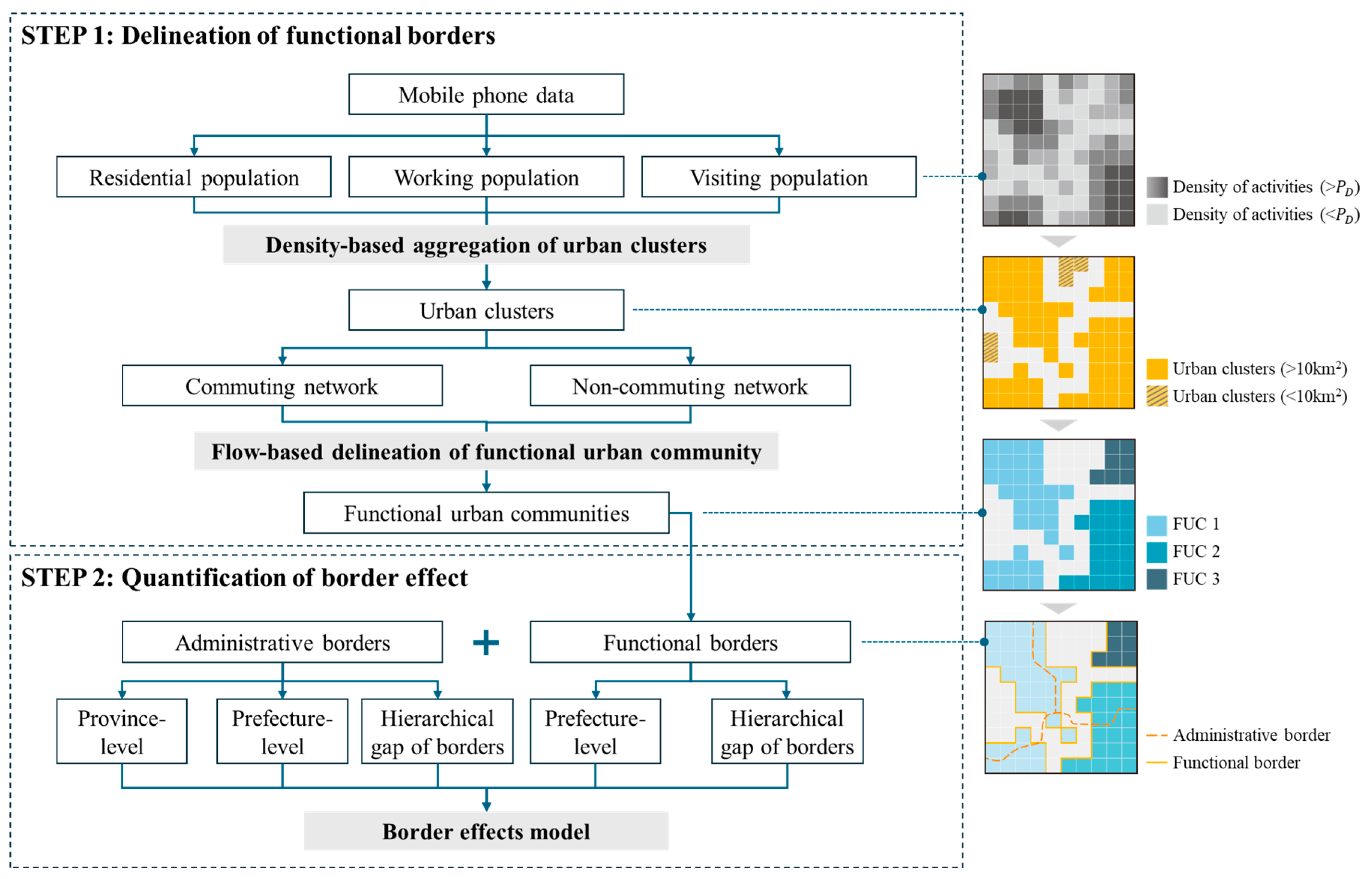
3.2.1. Delineating Functional Border
- (1)
- Density-based aggregation of urban clusters
- (2)
- Flow-based delineation of FUCs
- (3)
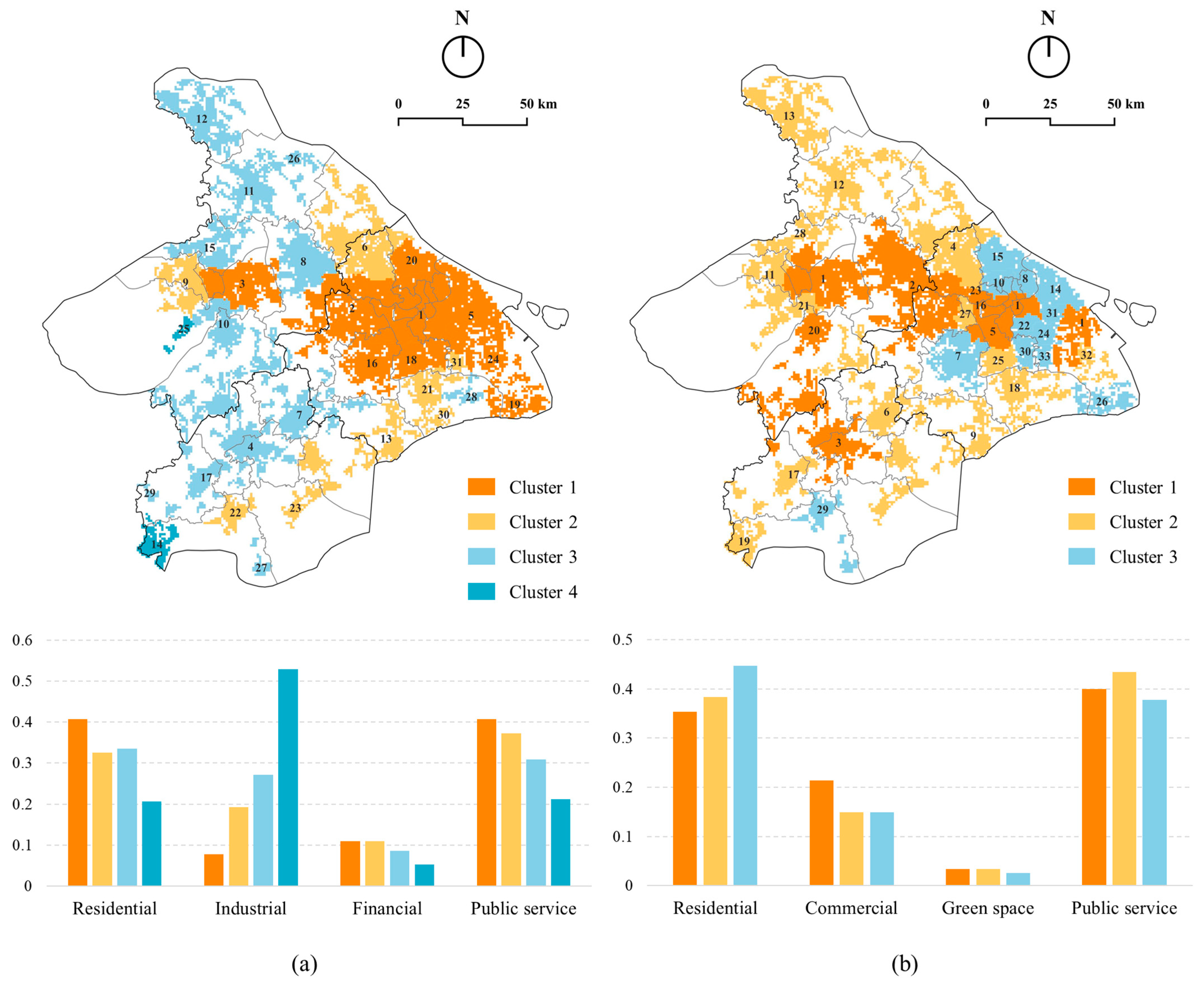
- Functional characterization of FUCs
- (4)
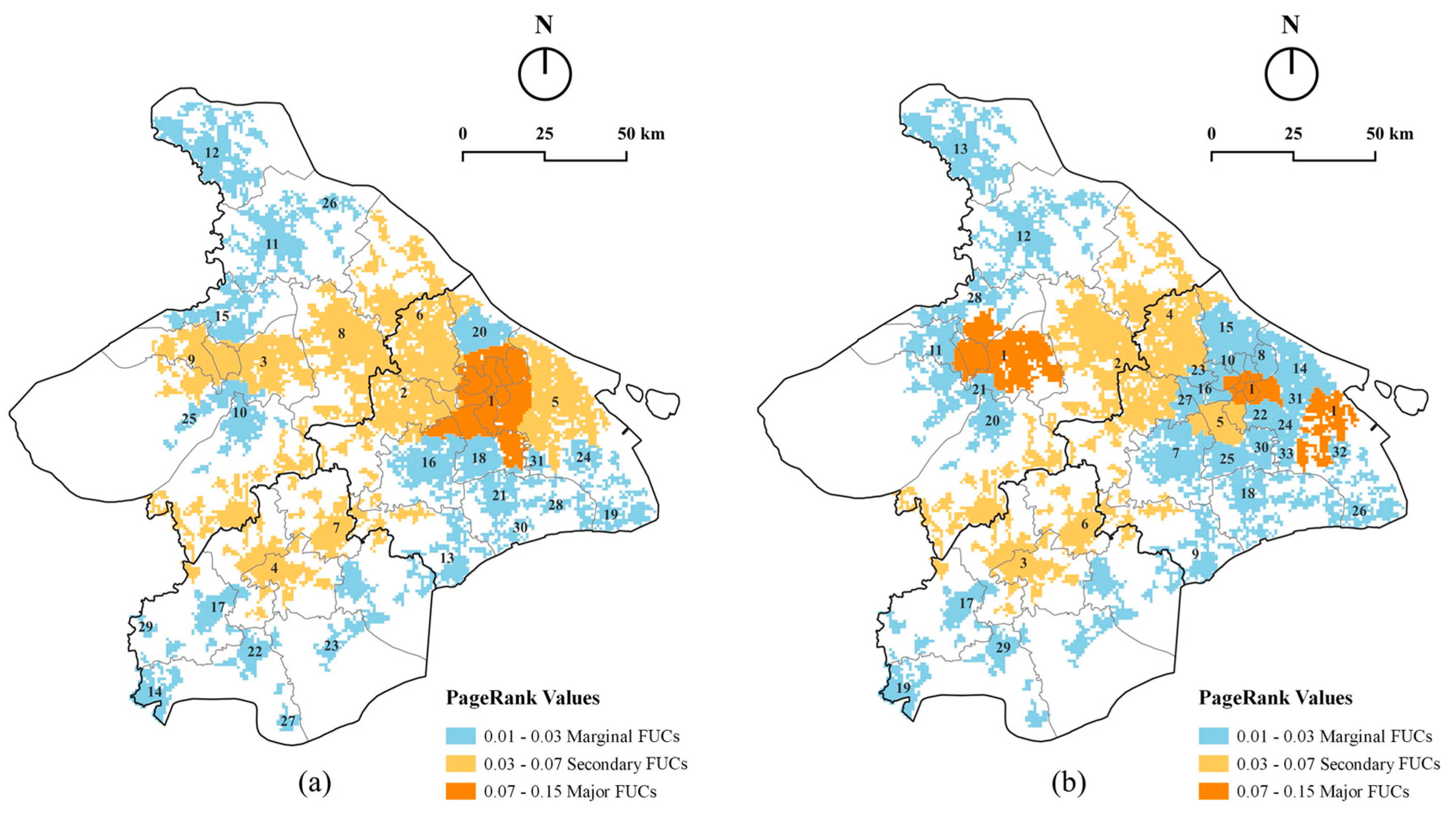
- Centrality analysis of FUCs
3.2.2. Quantifying Border Effect
4. Empirical Results
4.1. Delineation of Functional Borders
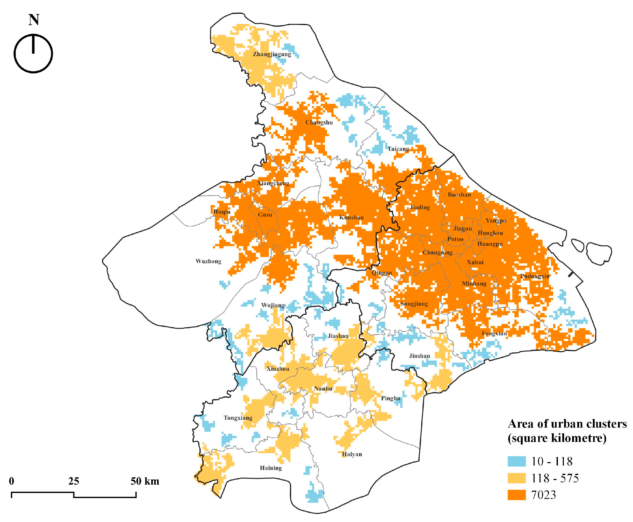
4.1.1. Aggregating Urban Clusters
4.1.2. Delineating and Characterizing Functional Urban Communities
4.2. The Effects of Administrative and Functional Borders
4.2.1. Border Effect on Commuting and Non-Commuting Flows
4.2.2. Spatial Characteristic of Province Border Effect
5. Discussion
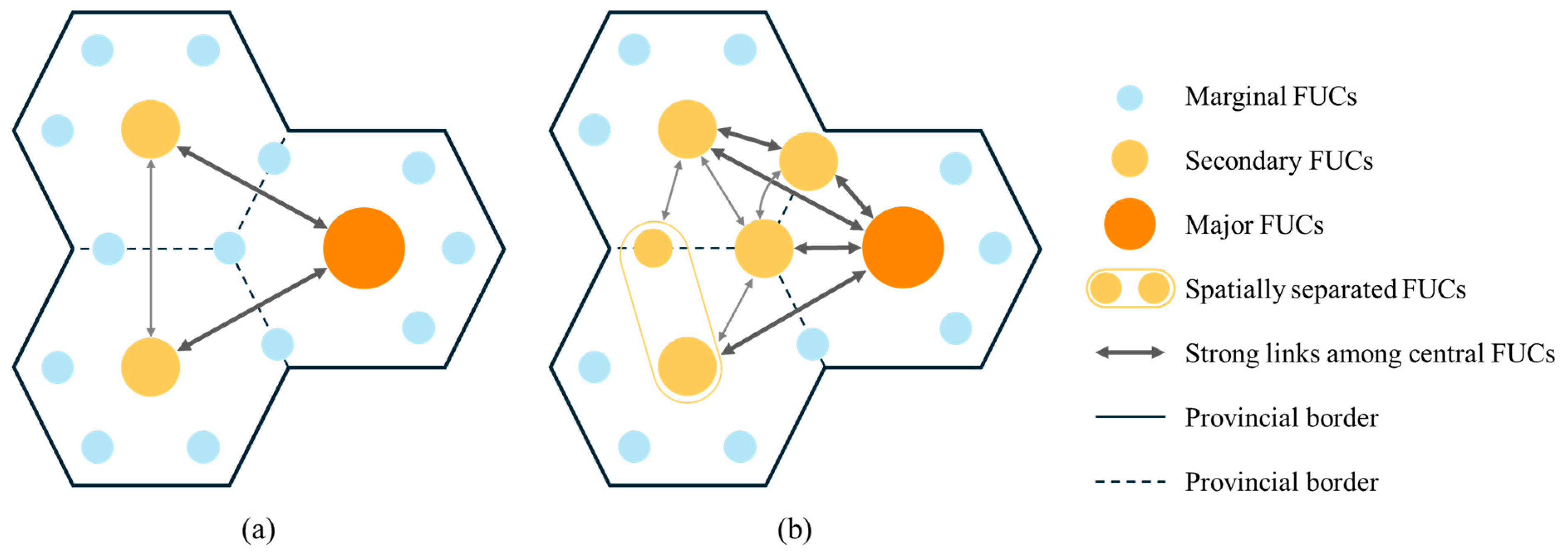
5.1. Multi-Activity Networks: The Cross-Border Polycentric Spatial Structure of Mega-City Region
5.2. Multi-Border Effect: Hybrid Influencing Factors of Spatial Interaction
5.3. Policy Implications
6. Conclusions
Supplementary Materials
Author Contributions
Funding
Data Availability Statement
Conflicts of Interest
References
- Chen, N. Intra-national versus international trade in the European Union: Why do national borders matter? J. Int. Econ. 2004, 63, 93–118. [Google Scholar] [CrossRef]
- Evans, C.L. The economic significance of national border effects. Am. Econ. Rev. 2003, 93, 1291–1312. [Google Scholar] [CrossRef]
- Feenstra, R.C. Border effects and the gravity equation: Consistent methods for estimation. Scott. J. Political Econ. 2002, 49, 491–506. [Google Scholar] [CrossRef]
- McCallum, J. National Borders Matter: Canada-U.S. Regional Trade Patterns. Am. Econ. Rev. 1995, 85, 615–623. [Google Scholar]
- Sohn, C. Modelling Cross-Border Integration: The Role of Borders as a Resource. Geopolitics 2014, 19, 587–608. [Google Scholar] [CrossRef]
- Sohn, C.; Licheron, J. The multiple effects of borders on metropolitan functions in Europe. Reg. Stud. 2018, 52, 1512–1524. [Google Scholar] [CrossRef]
- Yin, J.; Soliman, A.; Yin, D.; Wang, S. Depicting urban boundaries from a mobility network of spatial interactions: A case study of Great Britain with geo-located Twitter data. Int. J. Geogr. Inf. Sci. 2017, 31, 1293–1313. [Google Scholar] [CrossRef]
- De Montis, A.; Caschili, S.; Chessa, A. Commuter networks and community detection: A method for planning sub regional areas. Eur. Phys. J. Spec. Top. 2013, 215, 75–91. [Google Scholar] [CrossRef]
- Ma, S.; Long, Y. Functional urban area delineations of cities on the Chinese mainland using massive Didi ride-hailing records. Cities 2020, 97, 102532. [Google Scholar] [CrossRef]
- Farmer, C.J.Q.; Fotheringham, A.S. Network-based functional regions. Environ. Plan. A Econ. Space 2011, 43, 2723–2741. [Google Scholar] [CrossRef]
- Jin, M.; Gong, L.; Cao, Y.; Zhang, P.; Gong, Y.; Liu, Y. Identifying borders of activity spaces and quantifying border effects on intra-urban travel through spatial interaction network. Comput. Environ. Urban Syst. 2021, 87, 101625. [Google Scholar] [CrossRef]
- Chen, W.; Chen, X.; Cheng, L.; Liu, X.; Chen, J. Delineating borders of urban activity zones with free-floating bike sharing spatial interaction network. J. Transp. Geogr. 2022, 104, 103442. [Google Scholar] [CrossRef]
- Shen, Y.; Batty, M. Delineating the perceived functional regions of London from commuting flows. Environ. Plan. A Econ. Space 2019, 51, 547–550. [Google Scholar] [CrossRef]
- Liu, X.; Gong, L.; Gong, Y.X.; Liu, Y. Revealing travel patterns and city structure with taxi trip data. J. Transp. Geogr. 2015, 43, 78–90. [Google Scholar] [CrossRef]
- Liu, J.; Meng, B.; Shi, C. A multi-activity view of intra-urban travel networks: A case study of Beijing. Cities 2023, 143, 104634. [Google Scholar] [CrossRef]
- Anderson, J.E.; van Wincoop, E. Gravity with gravitas: A solution to the border puzzle. Am. Econ. Rev. 2003, 93, 170–192. [Google Scholar] [CrossRef]
- Zhang, B.; Zhong, C.; Gao, Q.; Shabrina, Z.; Tu, W. Delineating urban functional zones using mobile phone data: A case study of cross-boundary integration in Shenzhen-Dongguan-Huizhou area. Comput. Environ. Urban Syst. 2022, 98, 101872. [Google Scholar] [CrossRef]
- Zhang, W.; Fang, C.; Zhou, L.; Zhu, J. Measuring megaregional structure in the Pearl River Delta by mobile phone signaling data: A complex network approach. Cities 2020, 104, 102809. [Google Scholar] [CrossRef]
- Ding, C.; Liu, C.; Zhang, Y.; Yang, J.; Wang, Y. Investigating the impacts of built environment on vehicle miles traveled and energy consumption: Differences between commuting and non-commuting trips. Cities 2017, 68, 25–36. [Google Scholar] [CrossRef]
- Liu, J.; Meng, B.; Yang, M.; Peng, X.; Zhan, D.; Zhi, G. Quantifying spatial disparities and influencing factors of home, work, and activity space separation in Beijing. Habitat Int. 2022, 126, 102621. [Google Scholar] [CrossRef]
- Burger, M.J.; Van der Knaap, B.; Wall, R.S. Polycentricity and the Multiplexity of Urban Networks. Eur. Plan. Stud. 2014, 22, 816–840. [Google Scholar] [CrossRef]
- Shu, X.; Han, H.; Huang, C.; Li, L. Defining Functional Polycentricity From a Geographical Perspective. Geogr. Anal. 2020, 52, 169–189. [Google Scholar] [CrossRef]
- Cui, C.; Wu, X.; Liu, L.; Zhang, W. The spatial-temporal dynamics of daily intercity mobility in the Yangtze River Delta: An analysis using big data. Habitat Int. 2020, 106, 102174. [Google Scholar] [CrossRef]
- Wu, C.; Smith, D.; Wang, M.S. Simulating the urban spatial structure with spatial interaction: A case study of urban polycentricity under different scenarios. Comput. Environ. Urban Syst. 2021, 89, 101677. [Google Scholar] [CrossRef]
- Zhou, M.; Yue, Y.; Li, Q.; Wang, D. Portraying Temporal Dynamics of Urban Spatial Divisions with Mobile Phone Positioning Data: A Complex Network Approach. ISPRS Int. J. Geo-Inf. 2016, 5, 240. [Google Scholar] [CrossRef]
- Wang, T.; Yue, W.; Ye, X.; Liu, Y.; Lu, D. Re-evaluating polycentric urban structure: A functional linkage perspective. Cities 2020, 101, 102672. [Google Scholar] [CrossRef]
- Yu, Q.; Li, W.; Yang, D.; Zhang, H. Mobile Phone Data in Urban Commuting: A Network Community Detection-Based Framework to Unveil the Spatial Structure of Commuting Demand. J. Adv. Transp. 2020, 2020, 8835981. [Google Scholar] [CrossRef]
- Liu, X.T.; Huang, J.W.; Lai, J.; Zhang, J.; Senousi, A.M.; Zhao, P. Analysis of urban agglomeration structure through spatial network and mobile phone data. Trans. GIS 2021, 25, 1949–1969. [Google Scholar] [CrossRef]
- Yu, W.; Shao, Z.; Huang, X.; Li, D.; Fan, Y.; Xu, X. Multi-scale cross-city community detection of urban agglomeration using signaling big data. Geo-Spat. Inf. Sci. 2023, 27, 1348–1361. [Google Scholar] [CrossRef]
- Chen, Z.; Yeh, A.G.-O. Delineating functional urban areas in Chinese mega city regions using fine-grained population data and cellphone location data: A case of Pearl River Delta. Comput. Environ. Urban Syst. 2022, 93, 101771. [Google Scholar] [CrossRef]
- Fischer, M.M.; Scherngell, T.; Jansenberger, E. The geography of knowledge spillovers between high-technology firms in Europe: Evidence from a spatial interaction modeling perspective. Geogr. Anal. 2006, 38, 288–309. [Google Scholar] [CrossRef]
- Hjaltadottir, R.E.; Makkonen, T.; Mitze, T. Inter-regional innovation cooperation and structural heterogeneity: Does being a rural, or border region, or both, make a difference? J. Rural Stud. 2020, 74, 257–270. [Google Scholar] [CrossRef]
- Persyn, D.; Torfs, W. A gravity equation for commuting with an application to estimating regional border effects in Belgium. J. Econ. Geogr. 2016, 16, 155–175. [Google Scholar] [CrossRef]
- Capello, R.; Caragliu, A.; Fratesi, U. Measuring border effects in European cross-border regions. Reg. Stud. 2018, 52, 986–996. [Google Scholar] [CrossRef]
- Li, X.; Xu, X. On the temporo-spatial variations of the border effects: Approach and empirics. Geogr. Res. 2006, 25, 792–802. [Google Scholar]
- Wang, X.; Zhao, Z.; Cao, W.; Wang, S. Study of network characteristics and inter-provincial boundary effect of the Yangtze River Delta urban agglomeration: From the perspective of population flow. Geogr. Res. 2021, 40, 1621–1636. [Google Scholar]
- Wang, C.; Liu, H.; Zhang, M. Exploring the mechanism of border effect on urban land expansion: A case study of Beijing-Tianjin-Hebei region in China. Land Use Policy 2020, 92, 104424. [Google Scholar] [CrossRef]
- Batty, M. The New Science of Cities; The MIT Press: Cambridge, MA, USA, 2013. [Google Scholar]
- Batty, M.; Cheshire, J. Cities as Flows, Cities of Flows. Environ. Plan. B Plan. Des. 2011, 38, 195–196. [Google Scholar] [CrossRef]
- Sobolevsky, S.; Szell, M.; Campari, R.; Couronné, T.; Smoreda, Z.; Ratti, C. Delineating Geographical Regions with Networks of Human Interactions in an Extensive Set of Countries. PLoS ONE 2013, 8, e81707. [Google Scholar] [CrossRef]
- Ratti, C.; Sobolevsky, S.; Calabrese, F.; Andris, C.; Reades, J.; Martino, M.; Claxton, R.; Strogatz, S.H. Redrawing the Map of Great Britain from a Network of Human Interactions. PLoS ONE 2010, 5, e14248. [Google Scholar] [CrossRef]
- Kallus, Z.; Barankai, N.; Szüle, J.; Vattay, G. Spatial Fingerprints of Community Structure in Human Interaction Network for an Extensive Set of Large-Scale Regions. PLoS ONE 2015, 10, e0126713. [Google Scholar] [CrossRef] [PubMed]
- Zhang, J.; Liu, X.; Senousi, A.M. A multilayer mobility network approach to inferring urban structures using shared mobility and taxi data. Trans. Gis 2021, 25, 2840–2865. [Google Scholar] [CrossRef]
- Liu, X.; Yan, X.; Wang, W.; Titheridge, H.; Wang, R.; Liu, Y. Characterizing the polycentric spatial structure of Beijing Metropolitan Region using carpooling big data. Cities 2021, 109, 103040. [Google Scholar] [CrossRef]
- Cheng, Y.; LeGates, R. China’s hybrid global city region pathway: Evidence from the Yangtze River Delta. Cities 2018, 77, 81–91. [Google Scholar] [CrossRef]
- Tang, M.; Luo, X.L.; Ying, W.Y. Multi-level governance in the uneven integration of the city regions: Evidence of the Shanghai City Region, China. Habitat Int. 2022, 121, 102518. [Google Scholar] [CrossRef]
- The CPC Central Committee; General Office of the State Council. Outline of the Integrated Regional Development of the Yangtze River Delta; People’s Publishing House: Beijing, China, 2019. [Google Scholar]
- Wei, L.; Luo, Y.; Wang, M.; Cai, Y.Y.; Su, S.L.; Li, B.Z.; Ji, H.Y. Multiscale identification of urban functional polycentricity for planning implications: An integrated approach using geo-big transport data and complex network modeling. Habitat Int. 2020, 97, 102134. [Google Scholar] [CrossRef]
- Cao, W.; Dong, L.; Cheng, Y.; Wu, L.; Guo, Q.; Liu, Y. Constructing multi-level urban clusters based on population distributions and interactions. Comput. Environ. Urban Syst. 2023, 99, 101897. [Google Scholar] [CrossRef]
- Liu, K.; Murayama, Y.; Ichinose, T. Exploring the relationship between functional urban polycentricity and the regional characteristics of human mobility: A multi-view analysis in the Tokyo metropolitan area. Cities 2021, 111, 103109. [Google Scholar] [CrossRef]
- Rozenfeld, H.D.; Rybski, D.; Andrade, J.S.; Batty, M.; Stanley, H.E.; Makse, H.A. Laws of population growth. Proc. Natl. Acad. Sci. USA 2008, 105, 18702–18707. [Google Scholar] [CrossRef]
- Rozenfeld, H.D.; Rybski, D.; Gabaix, X.; Makse, H.A. The Area and Population of Cities: New Insights from a Different Perspective on Cities. Am. Econ. Rev. 2011, 101, 2205–2225. [Google Scholar] [CrossRef]
- Javed, M.A.; Younis, M.S.; Latif, S.; Qadir, J.; Baig, A. Community detection in networks: A multidisciplinary review. J. Netw. Comput. Appl. 2018, 108, 87–111. [Google Scholar] [CrossRef]
- Rosvall, M.; Bergstrom, C.T. Maps of random walks on complex networks reveal community structure. Proc. Natl. Acad. Sci. USA 2008, 105, 1118–1123. [Google Scholar] [CrossRef] [PubMed]
- Ahn, Y.-Y.; Bagrow, J.P.; Lehmann, S. Link communities reveal multiscale complexity in networks. Nature 2010, 466, 761–764. [Google Scholar] [CrossRef] [PubMed]
- Fortunato, S. Community detection in graphs. Phys. Rep. 2010, 486, 75–174. [Google Scholar] [CrossRef]
- Bohlin, L.; Edler, D.; Lancichinetti, A.; Rosvall, M. Community Detection and Visualization of Networks with the Map Equation Framework. In Measuring Scholarly Impact: Methods and Practice; Ding, Y., Rousseau, R., Wolfram, D., Eds.; Springer International Publishing: Cham, Switzerland, 2014; pp. 3–34. [Google Scholar]
- Aldecoa, R.; Marín, I. Exploring the limits of community detection strategies in complex networks. Sci. Rep. 2013, 3, 2216. [Google Scholar] [CrossRef]
- Edler, D.; Guedes, T.; Zizka, A.; Rosvall, M.; Antonelli, A. Infomap Bioregions: Interactive Mapping of Biogeographical Regions from Species Distributions. Syst. Biol. 2016, 66, 197–204. [Google Scholar] [CrossRef]
- Velden, T.; Yan, S.; Lagoze, C. Mapping the cognitive structure of astrophysics by infomap clustering of the citation network and topic affinity analysis. Scientometrics 2017, 111, 1033–1051. [Google Scholar] [CrossRef]
- Yao, Y.; Wang, J.; Hong, Y.; Qian, C.; Guan, Q.; Liang, X.; Dai, L.; Zhang, J. Discovering the homogeneous geographic domain of human perceptions from street view images. Landsc. Urban Plan. 2021, 212, 104125. [Google Scholar] [CrossRef]
- Brin, S.; Page, L. The anatomy of a large-scale hypertextual Web search engine. Comput. Netw. ISDN Syst. 1998, 30, 107–117. [Google Scholar] [CrossRef]
- Xu, J.; Li, A.; Li, D.; Liu, Y.; Du, Y.; Pei, T.; Ma, T.; Zhou, C. Difference of urban development in China from the perspective of passenger transport around Spring Festival. Appl. Geogr. 2017, 87, 85–96. [Google Scholar] [CrossRef]
- Kabir, M.; Salim, R.; Al-Mawali, N. The gravity model and trade flows: Recent developments in econometric modeling and empirical evidence. Econ. Anal. Policy 2017, 56, 60–71. [Google Scholar] [CrossRef]
- Huang, L.; Yang, Y.; Gao, H.; Zhao, X.; Du, Z. Comparing Community Detection Algorithms in Transport Networks via Points of Interest. IEEE Access 2018, 6, 29729–29738. [Google Scholar] [CrossRef]
- Lu, X.; Yang, G.; Chen, S. An Improved Method to Identify Built-Up Areas of Urban Agglomerations in Eastern and Western China Based on Multi-Source Data Fusion. Land 2024, 13, 974. [Google Scholar] [CrossRef]
- Li, K.; Niu, X. Delineation of the Shanghai Megacity Region of China from a Commuting Perspective: Study Based on Cell Phone Network Data in the Yangtze River Delta. J. Urban Plan. Dev. 2021, 147, 04021022. [Google Scholar] [CrossRef]
- Zhou, Y.; Yang, C.; Chen, M.; Liu, Y.; Yuan, Q. Commuting versus consumption: The role of core city in a metropolitan area. Cities 2023, 141, 104495. [Google Scholar] [CrossRef]
- Wang, C.; Liu, H.; Zhang, M.; Wei, Z. The border effect on urban land expansion in China: The case of Beijing-Tianjin-Hebei region. Land Use Policy 2018, 78, 287–294. [Google Scholar] [CrossRef]
- Shanghai Municipal People’s Government; Jiangsu Provincial People’s Government; Zhejiang Provincial People’s Government. Spatial Cooperative Plan of Greater Shanghai Metropolitan Area; Shanghai Municipal People’s Government: Shanghai, China; Jiangsu Provincial People’s Government: Nanjing, China; Zhejiang Provincial People’s Government: Hangzhou, China, 2022. [Google Scholar]
- Tordoir, P.P.; van Raan, A.F.J.; Poorthuis, A. Effects of municipal boundaries measured by combining urban scaling and spatial interaction. J. R. Soc. Interface 2023, 20, 20220775. [Google Scholar] [CrossRef]



| Studies | Spatial Scale | Spatial Units | Data Sources | Principle of Data Clustering |
|---|---|---|---|---|
| Liu et al. [14] | City | Regular grids | Taxi trip | - |
| Zhou et al. [25] | City | Regular grids and TAZs | Mobile phone | - |
| Yin et al. [7] | National | Regular grids | Social media | - |
| Wang et al. [26] | City | Communities | Taxi trip | - |
| Yu et al. [27] | City | TAZs | Mobile phone | Commuting activity |
| Zhang et al. [18] | Mega-city region | Districts/counties | Mobile phone | Commuting activity |
| Liu et al. [28] | Mega-city region | Districts/counties | Mobile phone | - |
| Jin et al. [11] | City | TAZs | Mobile phone | - |
| Chen et al. [12] | City | TAZs | Free-floating bike | - |
| Zhang et al. [17] | City region | Sub-districts | Mobile phone | Commuting activity |
| Yu et al. [29] | Mega-city region | Voronoi polygons | Mobile phone | Weekdays and weekends |
| Liu et al. [15] | City | Regular grids | Mobile phone | Multi-activity |
| This study | Mega-city region | Regular grids | Mobile phone | Multi-activity |
| Person ID | Residence Grid | Workplace Grid | Visit Place Grid 1 | Visit Place Grid 2 | … |
|---|---|---|---|---|---|
| 1 | L_40271 | L_48611 | L_50232 | L_25889 | … |
| 2 | L_47914 | L_30998 | L_56496 | L_48611 | … |
| … | … | … | … | … | … |
| Origin (O) Gird ID | Destination (D) Grid ID | Number of Commuters | Number of Non-Commuters |
|---|---|---|---|
| L_40271 | L_48611 | 98 | 6 |
| L_40271 | L_50232 | 52 | 18 |
| … | … | … | … |
| Types of Borders | Variables | Adds. | Value |
|---|---|---|---|
| Administrative border | Provincial border | 1 | |
| District/county border | 1 | ||
| Administrative hierarchical gap | |||
| Functional border | FUC border | 1 | |
| Functional hierarchical gap |
| The Rank of Administrative Districts/Counties (A) | The Rank of FUCs (F) | Value |
|---|---|---|
| Districts of provincial-level municipality (districts of Shanghai) | Major FUCs | 2 |
| Districts of prefecture-level cities (districts of Suzhou and Jiaxing) | Secondary FUCs | 1 |
| Counties of prefecture-level cities (counties of Suzhou and Jiaxing) | Marginal FUCs | 0 |
| Variables | Commuting Flows | Non-Commuting Flows | ||||||
|---|---|---|---|---|---|---|---|---|
| Model I | Model II | Model III | Model IV | Model I | Model II | Model III | Model IV | |
| Coef. | Coef. | Coef. | Coef. | Coef. | Coef. | Coef. | Coef. | |
| Constant | 0.186 *** (0.008) | −0.109 *** (0.008) | 0.118 *** (0.008) | −0.078 *** (0.008) | 1.330 *** (0.010) | 1.190 *** (0.010) | 1.200 *** (0.010) | 1.177 *** (0.010) |
| O population | 0.191 *** (0.001) | 0.215 *** (0.001) | 0.194 *** (0.001) | 0.214 *** (0.001) | 0.118 *** (0.010) | 0.136 *** (0.001) | 0.125 *** (0.001) | 0.136 *** (0.001) |
| D population | 0.151 *** (0.001) | 0.201 *** (0.001) | 0.155 *** (0.001) | 0.200 *** (0.001) | 0.104 *** (0.010) | 0.130 *** (0.001) | 0.111 *** (0.001) | 0.130 *** (0.001) |
| Distance | 0.406 *** (0.001) | 0.669 *** (0.001) | 0.595 *** (0.001) | 0.676 *** (0.001) | 0.428 *** (0.010) | 0.650 *** (0.001) | 0.586 *** (0.001) | 0.642 *** (0.002) |
| Province border | 1.226 *** (0.003) | 1.235 *** (0.003) | 1.091 *** (0.003) | 1.080 *** (0.004) | ||||
| District/county border | −0.126 *** (0.002) | −0.129 *** (0.002) | −0.020 *** (0.002) | −0.006 *** (0.002) | ||||
| Administrative hierarchical gap | −0.119 *** (0.001) | −0.121 *** (0.001) | −0.111 *** (0.002) | −0.109 *** (0.002) | ||||
| FUC border | −0.002 *** (0.002) | −0.001 *** (0.002) | −0.180 *** (0.003) | −0.043 *** (0.003) | ||||
| Functional hierarchical gap | 0.015 *** (0.001) | 0.028 *** (0.002) | −0.019 *** (0.001) | −0.010 *** (0.001) | ||||
| Adj. R2 | 0.276 | 0.393 | 0.305 | 0.409 | 0.283 | 0.375 | 0.315 | 0.395 |
| Variables | Commuting Flows | Non-Commuting Flows | ||||||
|---|---|---|---|---|---|---|---|---|
| Cross-Border FUCs | Non-Cross-Border FUCs | Cross-Border FUCs | Non-Cross-Border FUCs | |||||
| Model I | Model II | Model I | Model II | Model I | Model II | Model I | Model II | |
| Coef. | Coef. | Coef. | Coef. | Coef. | Coef. | Coef. | Coef. | |
| Constant | −1.243 *** (0.026) | −1.113 *** (0.025) | −0.332 *** (0.011) | −0.191 *** (0.010) | 0.001 *** (0.027) | −0.111 *** (0.026) | 0.798 *** (0.014) | 0.881 *** (0.012) |
| O population | 0.305 *** (0.002) | 0.303 *** (0.002) | 0.226 *** (0.001) | 0.233 *** (0.001) | 0.235 *** (0.002) | 0.238 *** (0.002) | 0.147 *** (0.001) | 0.168 *** (0.001) |
| D population | 0.281 *** (0.002) | 0.274 *** (0.002) | 0.174 *** (0.001) | 0.221 *** (0.001) | 0.226 *** (0.002) | 0.239 *** (0.002) | 0.126 *** (0.001) | 0.154 *** (0.001) |
| Distance | 0.796 *** (0.003) | 0.976 *** (0.003) | 0.437 *** (0.001) | 0.841 *** (0.001) | 0.928 *** (0.003) | 1.068 *** (0.003) | 0.437 *** (0.001) | 0.813 *** (0.002) |
| Province border | 0.764 *** (0.005) | 1.576 *** (0.003) | 0.709 *** (0.005) | 1.617 *** (0.004) | ||||
| Adj. R2 | 0.447 | 0.510 | 0.309 | 0.473 | 0.529 | 0.570 | 0.283 | 0.450 |
Disclaimer/Publisher’s Note: The statements, opinions and data contained in all publications are solely those of the individual author(s) and contributor(s) and not of MDPI and/or the editor(s). MDPI and/or the editor(s) disclaim responsibility for any injury to people or property resulting from any ideas, methods, instructions or products referred to in the content. |
© 2025 by the authors. Published by MDPI on behalf of the International Society for Photogrammetry and Remote Sensing. Licensee MDPI, Basel, Switzerland. This article is an open access article distributed under the terms and conditions of the Creative Commons Attribution (CC BY) license (https://creativecommons.org/licenses/by/4.0/).
Share and Cite
Li, Y.; Jiang, Y.; Duan, J. Quantifying Administrative and Functional Border Effects on Commuting and Non-Commuting Flows: A Case Study of the Shanghai-Suzhou-Jiaxing Area. ISPRS Int. J. Geo-Inf. 2025, 14, 133. https://doi.org/10.3390/ijgi14030133
Li Y, Jiang Y, Duan J. Quantifying Administrative and Functional Border Effects on Commuting and Non-Commuting Flows: A Case Study of the Shanghai-Suzhou-Jiaxing Area. ISPRS International Journal of Geo-Information. 2025; 14(3):133. https://doi.org/10.3390/ijgi14030133
Chicago/Turabian StyleLi, Yige, Ying Jiang, and Jin Duan. 2025. "Quantifying Administrative and Functional Border Effects on Commuting and Non-Commuting Flows: A Case Study of the Shanghai-Suzhou-Jiaxing Area" ISPRS International Journal of Geo-Information 14, no. 3: 133. https://doi.org/10.3390/ijgi14030133
APA StyleLi, Y., Jiang, Y., & Duan, J. (2025). Quantifying Administrative and Functional Border Effects on Commuting and Non-Commuting Flows: A Case Study of the Shanghai-Suzhou-Jiaxing Area. ISPRS International Journal of Geo-Information, 14(3), 133. https://doi.org/10.3390/ijgi14030133


