Development of an Ontology-Based Framework to Enhance Geospatial Data Discovery and Selection in Geoportals for Natural-Hazard Early Warning Systems
Abstract
1. Introduction
2. Related Work
2.1. Semantic Enhancement for Data Discovery and Understanding
2.2. Geospatial Data Quality and Fitness for Use
2.3. Geospatial Data Discovery Methods for Natural Hazard EWSs
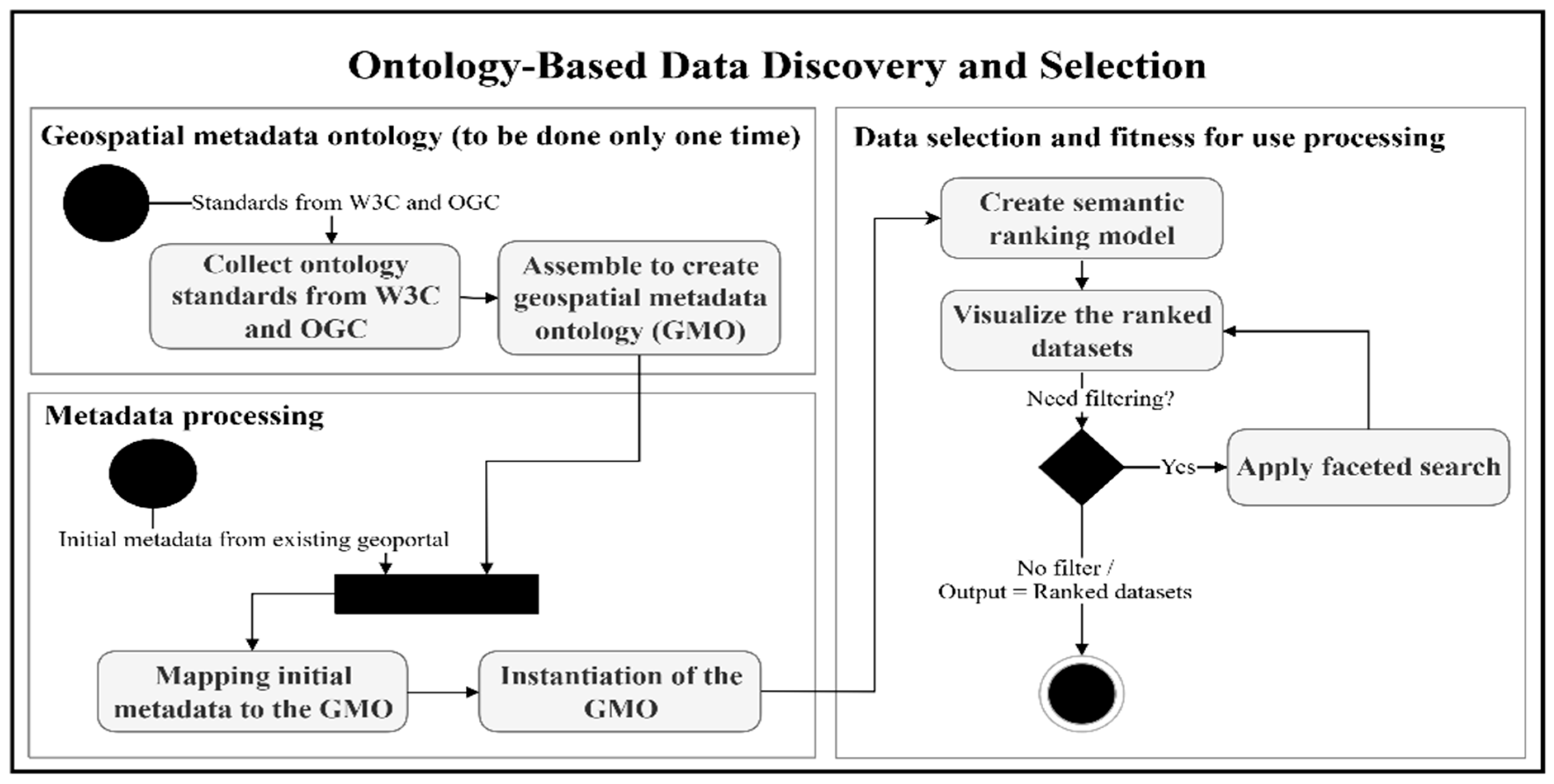
3. Ontology-Based Geospatial Data Discovery and Selection Framework
3.1. Introduction
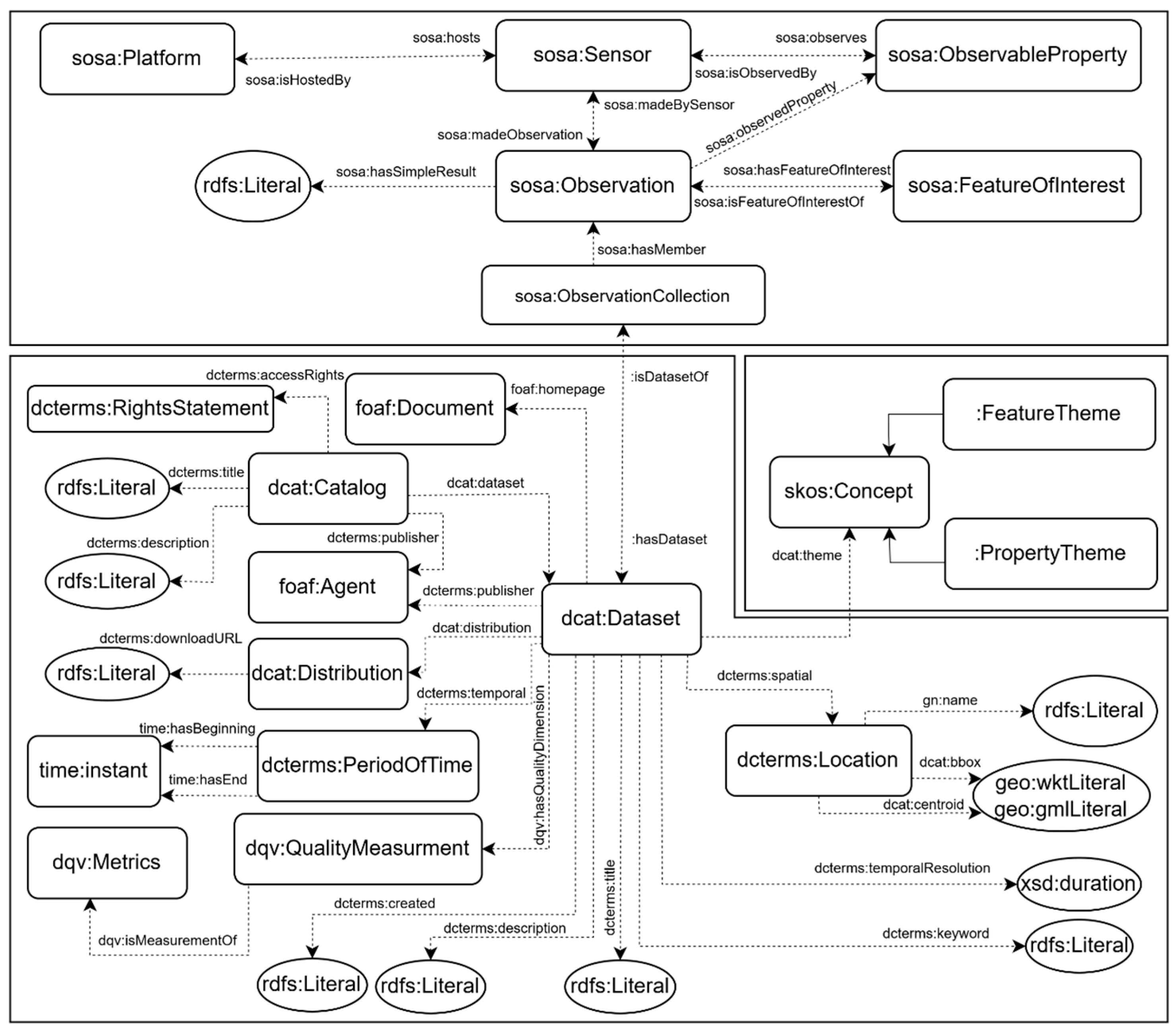
3.2. Geospatial Metadata Ontology
3.3. Metadata Processing
3.4. Data Selection and Fitness for Use Processing
- Atmosphere > Precipitation > Precipitation Amount > 3 Hour Precipitation Amount.
- Atmosphere > Precipitation > Precipitation Amount > 6 Hour Precipitation Amount.
- Atmosphere > Precipitation > Precipitation Amount > 12 Hour Precipitation Amount.
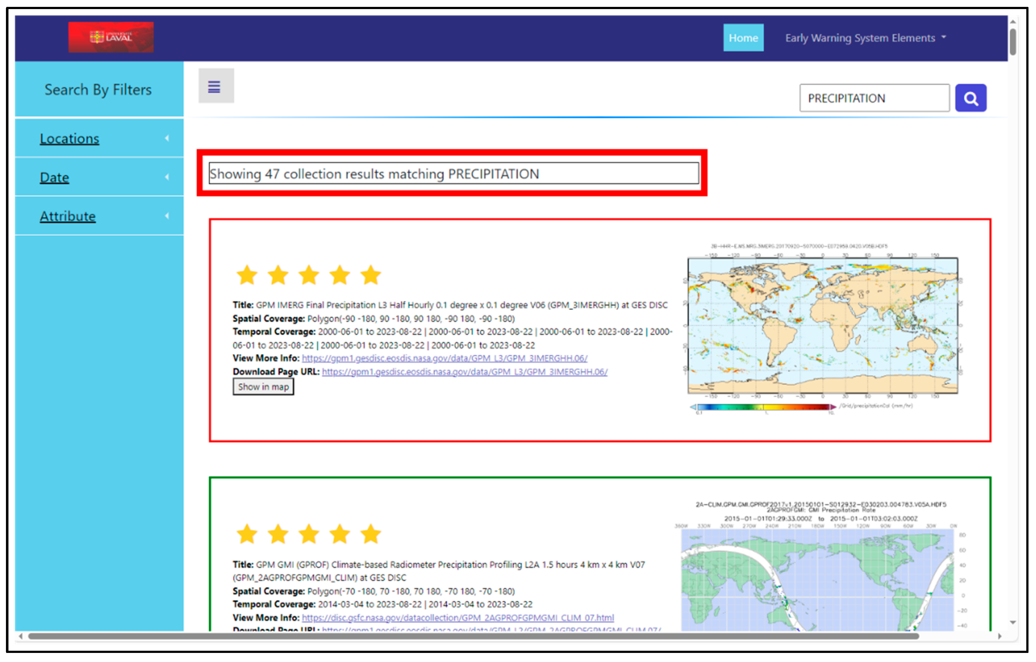
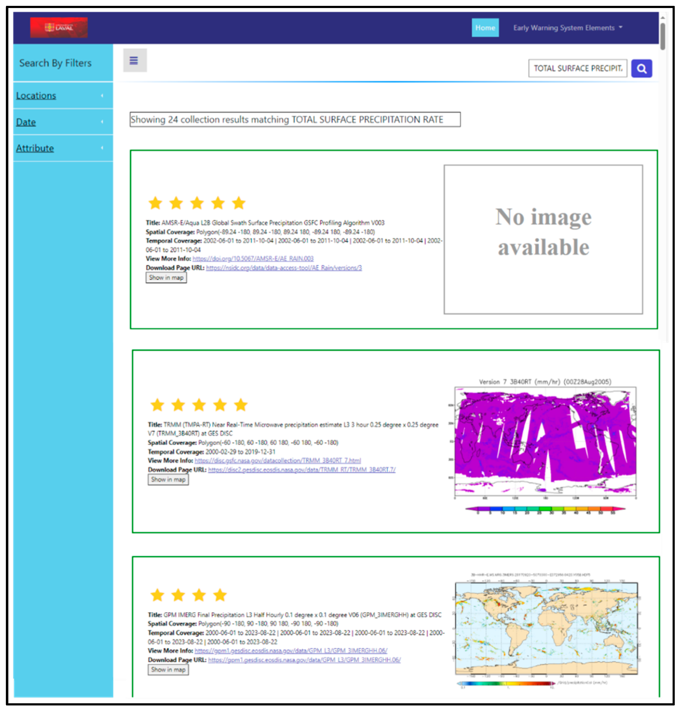
- Five stars are assigned to datasets with exact matches.
- Four stars are given to datasets with minimal semantic distance.
- Three stars are assigned to moderately relevant datasets.
- Two stars are given to datasets with lower relevance.
- One star is assigned to datasets with the least relevance but still related to the query.
- Compute Semantic Distances: First, the system computes the semantic distances between the user’s query concept and each dataset using the Q-TREE algorithm.
- Determine Maximum and Minimum Distances: Identify the maximum and minimum semantic distances among the retrieved datasets to define the range of relevance. A maximum distance threshold of four for narrower and sibling concepts (themes in the SKOS GCMD ontology) is applied in this study. This threshold corresponds to the typical depth of the GCMD thematic hierarchies, which generally range from three to five levels. Distances greater than four usually indicate only very broad conceptual overlap (e.g., at the root level), which is not meaningful for ranking datasets in terms of fitness for use. The value of four, therefore, balances coverage of relevant semantic relations with interpretability in the 5-star ranking system. Although various optimization methods exist, such as those discussed by Hervey et al. [52], this threshold was selected to maintain a straightforward and practically interpretable approach in the context of this study.
- Normalize Distances: Normalize the distances to a 0–1 scale using Equation (2):
- Map to Star Ratings: Convert the normalized distances to star ratings using predefined thresholds. The thresholds are selected to distribute the datasets evenly across the star ratings:
- Exact match: Five stars.
- (0, 0.2]: Four stars (minimal distance).
- (0.2, 0.4]: Three stars (moderately relevant).
- (0.4, 0.6]: Two stars (lower relevance).
- (0.6, 1]: One star (least relevance).
4. Ontology for Required Geospatial Information in Natural Hazard EWSs
5. Testing the Feasibility of the GeoFit Framework in a Geoportal
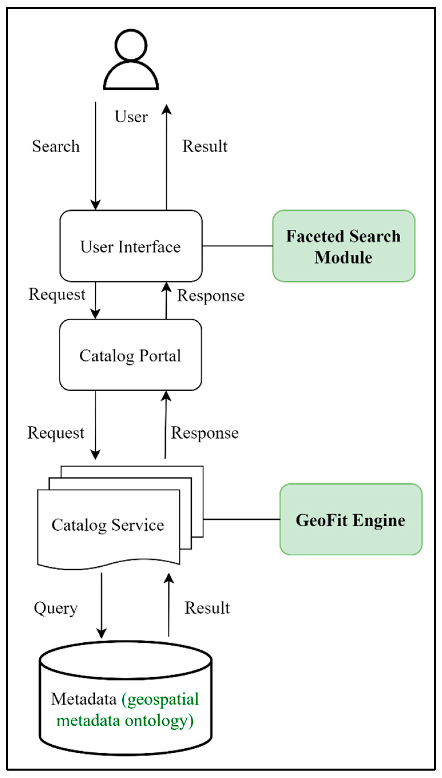
5.1. System Architecture
5.2. Technical Supports for Testing the Feasibility of the Ontology-Based Geospatial Data Discovery Framework
5.3. System Workflow for Feasibility Testing
- (a)
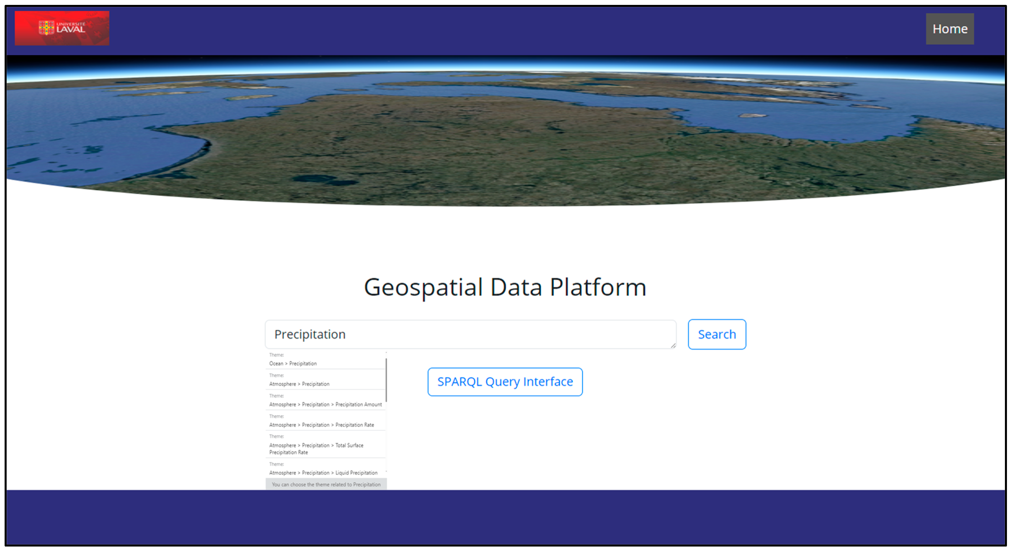
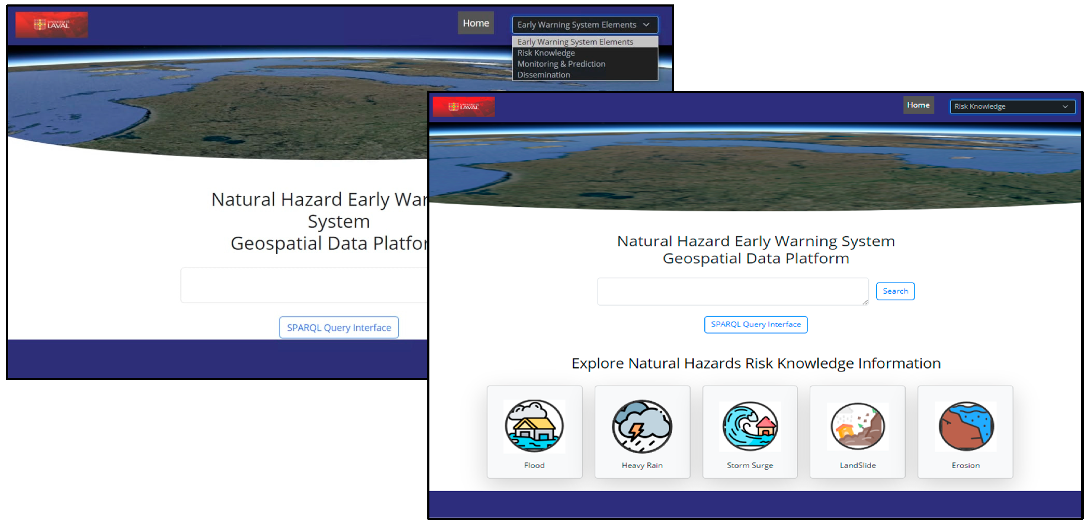
- User Search Interaction: The system’s web interface is designed with a user-centric approach to streamline data discovery. As shown in Figure 6, users start by entering a search query into the system’s web interface. This search box supports free-text queries, allowing users to input keywords or phrases related to the geospatial data they are looking for. Additionally, the interface includes a button for SPARQL queries, enabling users to perform advanced and precise searches using SPARQL. The auto-completion function calculates the semantic distance between the search query and theme terminologies, suggesting possible themes during typing.
- (b)
- Search filters based on the initial search results. The user interface sends a query for faceted search filters to the catalog portal, which forwards it to the catalog service and GeoFit Engine. The GeoFit Engine queries the ontology for filter data, which is sent back through the same path to the user interface. The user interface then updates the faceted search filters, displaying the results and updated filters to the user.Figure 7 shows the spatial coverage filter and the sensor-faceted search.
- (c)
- Semantic Ranking: To test the effectiveness of dataset relevance and semantic ranking in the geoportal, a total of 75 geospatial datasets related to three main themes were selected from relevant NASA data archives. These themes include the themes related to Precipitation (47 related datasets), Soil Moisture and Water Content (15 related datasets), and Digital Terrain Model (DTM) and Digital Elevation Model (DEM) (13 related datasets). The datasets were sourced from the following NASA data centers:
- Precipitation datasets from the NASA Goddard Earth Sciences Data and Information Services Center (GES DISC) (Available online: https://disc.gsfc.nasa.gov/, accessed on 19 September 2025).
- Soil Moisture/Water Content datasets from the NASA National Snow and Ice Data Center (NSIDC) (Available online: https://nsidc.org/home, accessed on 19 September 2025).
- DTM/DEM datasets from the NASA Land Processes Distributed Active Archive Center (LP DAAC) (Available online: https://lpdaac.usgs.gov/, accessed on 19 September 2025).
6. Evaluating the Added Value of GeoFit in Natural Hazard EWS Applications
6.1. Showcase on River Flood in Nunavik
6.2. Geoportal Interface for GeoNHEWS Data Discovery System
6.3. Testing the Ontology-Based Discovery Framework of EWS-Related Geospatial Data for the Flood
7. Discussion and Conclusions
Author Contributions
Funding
Acknowledgments
Conflicts of Interest
References
- Pulwarty, R.S.; Sivakumar, M.V.K. Information systems in a changing climate: Early warnings and drought risk management. Weather. Clim. Extrem. 2014, 3, 14–21. [Google Scholar] [CrossRef]
- Zschau, J.; Küppers, A.N. Early Warning Systems for Natural Disaster Reduction; Springer Science & Business Media: Berlin, Germany, 2013; pp. 3-1–3-12. [Google Scholar]
- Prudhomme, C.; Homburg, T.; Ponciano, J.J.; Boochs, F.; Cruz, C.; Roxin, A.M. Interpretation and automatic integration of geospatial data into the Semantic Web: Towards a process of automatic geospatial data interpretation, classification and integration using semantic technologies. Computing 2020, 102, 365–391. [Google Scholar] [CrossRef]
- Yu, M.; Yang, C.; Li, Y. Big data in natural disaster management: A review. Geosciences 2018, 8, 165. [Google Scholar] [CrossRef]
- Gomes, V.C.F.; Queiroz, G.R.; Ferreira, K.R. An overview of platforms for big earth observation data management and analysis. Remote Sens. 2020, 12, 1253. [Google Scholar] [CrossRef]
- Canada, S. Census Profile. 2021 Census of Population 2023. Available online: https://www12.statcan.gc.ca/census-recensement/2021/dp-pd/prof/index.cfm?Lang=E (accessed on 9 February 2022).
- Pérez Bello, A. Extreme Precipitation and Temperature Relationship in Current and Future Climate./Relations Entre Précipitations Extrêmes et Température en Climat Actuel et Futur. Ph.D. Thesis, Université du Québec, Institut National de la Recherche Scientifique, Québec, QC, Canada, 2023; 175p. [Google Scholar]
- Sheremata, M.; Tsuji, L.; Gough, W.A. Collaborative uses of geospatial technology to support climate change adaptation in indigenous communities of the Circumpolar North. In Geospatial Technology-Environmental and Social Applications; InTech: Rijeka, Croatia, 2016; pp. 197–215. [Google Scholar] [CrossRef]
- Gregory, K.; Groth, P.; Cousijn, H.; Scharnhorst, A.; Wyatt, S. Searching data: A review of observational data retrieval practices in selected disciplines. J. Assoc. Inf. Sci. Technol. 2019, 70, 419–432. [Google Scholar] [CrossRef]
- Ullah, K.; Zhang, J. GIS-based flood hazard mapping using relative frequency ratio method: A case study of Panjkora River Basin, eastern Hindu Kush, Pakistan. PLoS ONE 2020, 15, e0229153. [Google Scholar] [CrossRef]
- Wu, Y.; Abdel-Aty, M.; Park, J.; Selby, R.M. Effects of real-time warning systems on driving under fog conditions using an empirically supported speed choice modeling framework. Transp. Res. Part C Emerg. Technol. 2018, 86, 97–110. [Google Scholar] [CrossRef]
- Masó, J.; Pons, X.; Zabala, A. Tuning the second-generation SDI: Theoretical aspects and real use cases. Int. J. Geogr. Inf. Sci. 2012, 26, 983–1014. [Google Scholar] [CrossRef]
- Gui, Z.; Yang, C.; Xia, J.; Liu, K.; Xu, C.; Li, J.; Lostritto, P. A performance, semantic and service quality-enhanced distributed search engine for improving geospatial resource discovery. Int. J. Geogr. Inf. Sci. 2013, 27, 1109–1132. [Google Scholar] [CrossRef]
- Hu, Y.; Li, W. Spatial data infrastructures. arXiv 2017, arXiv:1707.03969. [Google Scholar] [CrossRef]
- Li, W.; Goodchild, M.F.; Raskin, R. Towards geospatial semantic search: Exploiting latent semantic relations in geospatial data. Int. J. Digit. Earth 2014, 7, 17–37. [Google Scholar] [CrossRef]
- Zhang, C.; Zhao, T.; Li, W. Automatic search of geospatial features for disaster and emergency management. Int. J. Appl. Earth Obs. Geoinf. 2010, 12, 409–418. [Google Scholar]
- Quarati, A.; De Martino, M.; Rosim, S. Geospatial open data usage and metadata quality. ISPRS Int. J. Geo-Inf. 2021, 10, 30. [Google Scholar] [CrossRef]
- Jiang, Y. Improving Geospatial Data Search Ranking Using Deep Learning and User Behaviour Data. Ph.D. Thesis, George Mason University, Fairfax, VA, USA, 2018. [Google Scholar]
- Devillers, R.; Bédard, Y.; Jeansoulin, R.; Moulin, B. Towards spatial data quality information analysis tools for experts assessing the fitness for use of spatial data. Int. J. Geogr. Inf. Sci. 2007, 21, 261–282. [Google Scholar] [CrossRef]
- Horita, F.E.A.; de Albuquerque, J.P.; Marchezini, V. Understanding the decision-making process in disaster risk monitoring and early-warning: A case study within a control room in Brazil. Int. J. Disaster Risk Reduct. 2018, 28, 22–31. [Google Scholar] [CrossRef]
- Qin, J.; D’Ignazio, J. The central role of metadata in a science data literacy course. J. Libr. Metad. 2010, 10, 188–204. [Google Scholar] [CrossRef]
- Kalantari, M.; Syahrudin, S.; Rajabifard, A.; Subagyo, H.; Hubbard, H. Spatial metadata usability evaluation. ISPRS Int. J. Geo-Inf. 2020, 9, 463. [Google Scholar]
- Wentz, E.; Shimizu, M. Measuring spatial data fitness-for-use through multiple criteria decision making. Ann. Am. Assoc. Geogr. 2018, 108, 1150–1167. [Google Scholar] [CrossRef]
- Van Oort, P. Spatial Data quality: From Description to Application. Ph.D. Thesis, Wageningen University and Research, Wageningen, The Netherlands, 2006. [Google Scholar]
- Vahdat, A. A New Approach to Enhance Geospatial Data Selection in Geoportals: Application for Supporting Natural Hazard Early Warning System in Nunavik, Québec. Ph.D. Thesis, Université Laval, Québec, QC, Canada, 2025. [Google Scholar]
- Li, W.; Yang, C.; Nebert, D.; Raskin, R.; Houser, P.; Wu, H.; Li, Z. Semantic-based web service discovery and chaining for building an Arctic spatial data infrastructure. Comput. Geosci. 2011, 37, 1752–1762. [Google Scholar] [CrossRef]
- Gray, J.; Liu, D.T.; Nieto-Santisteban, M.; Szalay, A.; DeWitt, D.J.; Heber, G. Scientific data management in the coming decade. ACM SIGMOD Rec. 2005, 34, 34–41. [Google Scholar] [CrossRef]
- Jiang, H.; van Genderen, J.; Mazzetti, P.; Koo, H.; Chen, M. Current status and future directions of geoportals. Int. J. Digit. Earth 2020, 13, 1093–1114. [Google Scholar]
- van den Brink, L.; Barnaghi, P.; Tandy, J.; Atemezing, G.; Atkinson, R.; Cochrane, B.; Fathy, Y.; García Castro, R.; Haller, A.; Harth, A. Best practices for publishing, retrieving, and using spatial data on the web. Semant. Web 2019, 10, 95–114. [Google Scholar]
- Li, W. Lowering the barriers for accessing distributed geospatial big data to advance spatial data science: The PolarHub solution. Ann. Am. Assoc. Geogr. 2018, 108, 773–793. [Google Scholar]
- Lutz, M.; Sprado, J.; Klien, E.; Schubert, C.; Christ, I. Overcoming semantic heterogeneity in spatial data infrastructures. Comput. Geosci. 2009, 35, 739–752. [Google Scholar] [CrossRef]
- Li, W. Automated Data Discovery, Reasoning and Ranking in Support of Building an Intelligent Geospatial Search Engine. Ph.D. Thesis, George Mason University, Fairfax, VA, USA, 2010. [Google Scholar]
- Gruber, T.R. A translation approach to portable ontology specifications. Knowl. Acquis. 1993, 5, 199–220. [Google Scholar] [CrossRef]
- Chandra, R.; Kumar, S.S.; Patra, R.; Agarwal, S. Decision support system for Forest fire management using Ontology with Big Data and LLMs. arXiv 2024, arXiv:2405.11346. [Google Scholar] [CrossRef]
- Bechhofer, S. OWL: Web ontology language. In Encyclopedia of Database Systems, 2nd ed.; Liu, L., Özsu, M.T., Eds.; Springer: New York, NY, USA, 2018; pp. 2640–2641. [Google Scholar]
- Sánchez-Zas, C.; Villagrá, V.A.; Vega-Barbas, M.; Larriva-Novo, X.; Moreno, J.I.; Berrocal, J. Ontology-based approach to real-time risk management and cyber-situational awareness. Future Gener. Comput. Syst. 2023, 141, 462–472. [Google Scholar] [CrossRef]
- Hamdani, Y.; Xiao, G.; Ding, L.; Calvanese, D. An ontology-based framework for geospatial integration and querying of raster data cube using virtual knowledge graphs. ISPRS Int. J. Geo-Inf. 2023, 12, 375. [Google Scholar]
- Martin, P.; Magagna, B.; Liao, X.; Zhao, Z. Semantic linking of research infrastructure metadata. In Towards Interoperable Research Infrastructures for Environmental and Earth Sciences: A Reference Model Guided Approach for Common Challenges; Springer: Cham, Switzerland, 2020; pp. 226–246. [Google Scholar]
- Zhang, F.; Lu, Q.; Du, Z.; Chen, X.; Cao, C. A comprehensive overview of RDF for spatial and spatiotemporal data management. Knowl. Eng. Rev. 2021, 36, e10. [Google Scholar] [CrossRef]
- Athanasis, N.; Kalabokidis, K.; Vaitis, M.; Soulakellis, N. Towards a semantics-based approach in the development of geographic portals. Comput. Geosci. 2009, 35, 301–308. [Google Scholar] [CrossRef]
- Frey, J.; Müller, K.; Hellmann, S.; Rahm, E.; Vidal, M.E. Evaluation of metadata representations in RDF stores. Semant. Web 2019, 10, 205–229. [Google Scholar] [CrossRef]
- Beretta, V.; Desconnets, J.-C.; Mougenot, I.; Arslan, M.; Barde, J.; Chaffard, V. A user-centric metadata model to foster sharing and reuse of multidisciplinary datasets in environmental and life sciences. Comput. Geosci. 2021, 154, 104807. [Google Scholar] [CrossRef]
- Janowicz, K.; Haller, A.; Cox, S.J.D.; Le Phuoc, D.; Lefrançois, M. SOSA: A lightweight ontology for sensors, observations, samples, and actuators. J. Web Semant. 2019, 56, 1–10. [Google Scholar] [CrossRef]
- Smits, P.C.; Friis-Christensen, A. Resource discovery in a European spatial data infrastructure. IEEE Trans. Knowl. Data Eng. 2006, 19, 85–95. [Google Scholar] [CrossRef]
- Vockner, B.; Mittlböck, M. Geo-enrichment and semantic enhancement of metadata sets to augment discovery in geoportals. ISPRS Int. J. Geo-Inf. 2014, 3, 345–367. [Google Scholar] [CrossRef]
- Li, W.; Song, M.; Tian, Y. An ontology-driven cyberinfrastructure for intelligent spatiotemporal question answering and open knowledge discovery. ISPRS Int. J. Geo-Inf. 2019, 8, 496. [Google Scholar] [CrossRef]
- Li, Y.; Jiang, Y.; Yang, C.; Yu, M.; Kamal, L.; Armstrong, E.M.; Huang, T.; Moroni, D.; McGibbney, L.J. Improving search ranking of geospatial data based on deep learning using user behavior data. Comput. Geosci. 2020, 142, 104520. [Google Scholar] [CrossRef]
- Vockner, B.; Belgiu, M.; Mittlboeck, M. Recommender-based enhancement of discovery in Geoportals. Int. J. Spat. Data Infrastruct. Res. 2012, 7, 441–463. [Google Scholar]
- Jiang, Y.; Li, Y.; Yang, C.; Hu, F.; Armstrong, E.M.; Huang, T.; Moroni, D.; McGibbney, L.J.; Greguska, F.; Finch, C.J. A smart web-based geospatial data discovery system with oceanographic data as an example. ISPRS Int. J. Geo-Inf. 2018, 7, 62. [Google Scholar] [CrossRef]
- Vockner, B.; Richter, A.; Mittlböck, M. From geoportals to geographic knowledge portals. ISPRS Int. J. Geo-Inf. 2013, 2, 256–275. [Google Scholar] [CrossRef]
- Wilson, G.; Devillers, R.; Hoeber, O. Fuzzy logic ranking for personalized geographic information retrieval. In Proceedings of the Third International Conference on Intelligent Human Computer Interaction (IHCI 2011), Prague, Czech Republic, 29–31 August 2011; pp. 111–123. [Google Scholar]
- Hervey, T.; Lafia, S.; Kuhn, W. Search facets and ranking in geospatial dataset search. In Proceedings of the 11th International Conference on Geographic Information Science (GIScience 2021)—Part I, Poznań, Poland, 27–30 September 2021; pp. 5:1–5:15. [Google Scholar]
- Qiu, L.; Du, Z.; Zhu, Q.; Fan, Y. An integrated flood management system based on linking environmental models and disaster-related data. Environ. Model. Softw. 2017, 91, 111–126. [Google Scholar] [CrossRef]
- Phengsuwan, J.; Shah, T.; James, P.; Thakker, D.; Barr, S.; Ranjan, R. Ontology-based discovery of time-series data sources for landslide early warning system. Computing 2020, 102, 745–763. [Google Scholar] [CrossRef]
- ISO 19115-1:2014; Geographic Information—Metadata—Part 1: Fundamentals. International Organization for Standardization: Geneva, Switzerland, 2014.
- ISO 19115-2:2019; Geographic Information—Metadata—Part 2: Extensions for Acquisition and Processing. International Organization for Standardization: Geneva, Switzerland, 2019.
- European Commission. Directive 2007/2/EC of the European Parliament and of the Council of 14 March 2007 Establishing an Infrastructure for Spatial Information in the European Community (INSPIRE). Official Journal of the European Union, L 108, 25 April 2007; 1–14. [Google Scholar]
- Perego, A.; Cetl, V.; Friis-Christensen, A.; Lutz, M. GeoDCAT-AP: Representing geographic metadata by using the “DCAT application profile for data portals in Europe”. In Proceedings of the Joint UNECE/UNGGIM Europe Workshop on Integrating Geospatial and Statistical Standards, Stockholm, Sweden, 6–8 November 2017. [Google Scholar]
- ISO 19110:2016; Geographic Information—Methodology for Feature Cataloguing. International Organization for Standardization: Geneva, Switzerland, 2016.
- ISO 19156:2011; Geographic Information—Observations and Measurements. International Organization for Standardization: Geneva, Switzerland, 2011.
- Lehmann, J.; Athanasiou, S.; Both, A.; Garcia Rojas, A.; Giannopoulos, G.; Hladky, D.; Le Grange, J.J.; Ngonga Ngomo, A.C.; Sherif, M.A.; Stadler, C.; et al. Managing geospatial linked data in the GeoKnow project. In The Semantic Web in Earth and Space Science: Current Status and Future Directions; IOS Press: Amsterdam, The Netherlands, 2015; pp. 51–78. [Google Scholar]
- Djidjev, H.N.; Pantziou, G.E.; Zaroliagis, C.D. Computing shortest paths and distances in planar graphs. In Proceedings of the 18th International Colloquium on Automata, Languages and Programming, Madrid, Spain, 8–12 July 1991; pp. 327–338. [Google Scholar]
- Kotsiantis, S.; Kanellopoulos, D. Discretization techniques: A recent survey. GESTS Int. Trans. Comput. Sci. Eng. 2006, 32, 47–58. [Google Scholar]
- Sreevalsan-Nair, J.; Mundayatt, A. Evolution of Data-driven Single- and Multi-Hazard Susceptibility Mapping and Emergence of Deep Learning Methods. arXiv 2025, arXiv:2502.09045. [Google Scholar]
- Van Westen, C.J. Remote sensing and GIS for natural hazards assessment and disaster risk management. In Treatise on Geomorphology; Elsevier: Amsterdam, The Netherlands, 2013; Volume 3, pp. 259–298. [Google Scholar]
- Sättele, M.; Bründl, M.; Straub, D. A classification of warning system for natural hazards. In Proceedings of the 10th International Probabilistic Workshop, Stuttgart, Germany, 15–16 November 2012; Moormann, C., Huber, M., Proske, D., Eds.; Institut für Geotechnik der Universität Stuttgart: Stuttgart, Germany, 2012; pp. 257–270. [Google Scholar]
- UNDRR: Early Warning Systems Terminology. Available online: https://www.undrr.org/terminology/early-warning-system (accessed on 15 June 2024).
- Prayudi, S.D. Multiparameter Land Subsidence Vulnerability Assessment through Satellite Imagery, GIS, and Spatial Data Integration. Bull. Geol. 2023, 7, 1261–1270. [Google Scholar]
- Nebert, D. Developing Spatial Data Infrastructures: The SDI Cookbook v. 2.0. Glob. Spat. Data Infrastruct. 2004, 2, 39–56. [Google Scholar]
- Rose, L. Geospatial Portal Reference Architecture: A Community Guide to Implementing Standards-Based Geospatial Portals. OpenGIS Discuss. Pap. 2004, OGC 04-039. Available online: https://portal.ogc.org/files/?artifact_id=6669 (accessed on 19 September 2025).
- Allard, M.; Aubé-Michaud, S.; L’Hérault, E.; Mathon-Dufour, V.; Deslauriers, C. Identification of Current and Potential Risks from Climate Change for Nunavik Community Territory—Phase 1: Summary Document, Community of Inukjuak; Final Report; Ministère de la Sécurité Publique (Government of Quebec), Centre for Northern Studies, Université Laval: Québec, QC, Canada, 2020; 64p.
- Allard, M.; Aubé-Michaud, S.; L’Hérault, E.; Mathon-Dufour, V.; Deslauriers, C. Identification of Current and Potential Risks from Climate Change for Nunavik Community Territory—Phase 1: Summary Document, Community of Ivujivik; Final Report; Ministère de la Sécurité Publique (Government of Quebec), Centre for Northern Studies, Université Laval: Québec, QC, Canada, 2020; 61p.
- Allard, M.; Aubé-Michaud, S.; L’Hérault, E.; Mathon-Dufour, V.; Deslauriers, C. Identification of Current and Potential Risks from Climate Change for Nunavik Community Territory—Phase 1: Summary Document, Community of Kangiqsujuaq; Final Report; Ministère de la Sécurité Publique (Government of Quebec), Centre for Northern Studies, Université Laval: Québec, QC, Canada, 2020; 63p.
- Allard, M.; Aubé-Michaud, S.; L’Hérault, E.; Mathon-Dufour, V.; Deslauriers, C. Identification of Current and Potential Risks from Climate Change for Nunavik Community Territory—Phase 1: Summary Document, Community of Puvirnituq; Final Report; Ministère de la Sécurité Publique (Government of Quebec), Centre for Northern Studies, Université Laval: Québec, QC, Canada, 2020; 68p.
- Allard, M.; Aubé-Michaud, S.; L’Hérault, E.; Mathon-Dufour, V.; Deslauriers, C. Identification of Current and Potential Risks from Climate Change for Nunavik Community Territory—Phase 1: Summary Document, Community of Quaqtaq; Final Report; Ministère de la Sécurité Publique (Government of Quebec), Centre for Northern Studies, Université Laval: Québec, QC, Canada, 2020; 70p.
- Allard, M.; Aubé-Michaud, S.; L’Hérault, E.; Mathon-Dufour, V.; Deslauriers, C.; Chiasson, A. Identification of Current and Potential Risks from Climate Change for Nunavik Community Territory—Phase 2: Summary Document, Community of Akulivik; Final Report; Ministère de la Sécurité Publique (Government of Quebec), Centre for Northern Studies, Université Laval: Québec, QC, Canada, 2020; 63p.
- Allard, M.; Aubé-Michaud, S.; Mathon-Dufour, V.; Deslauriers, C.; Chiasson, A. Identification of Current and Potential Risks from Climate Change for Nunavik Community Territory—Phase 2: Summary Document, Community of Aupaluk; Final Report; Ministère de la Sécurité Publique (Government of Quebec), Centre for Northern Studies, Université Laval: Québec, QC, Canada, 2020; 62p.
- Allard, M.; Aubé-Michaud, S.; Mathon-Dufour, V.; Deslauriers, C.; Chiasson, A. Identification of Current and Potential Risks from Climate Change for Nunavik Community Territory—Phase 2: Summary Document, Community of Kuujjuarapik; Final Report; Ministère de la Sécurité Publique (Government of Québec), Centre for Northern Studies, Université Laval: Québec, QC, Canada, 2020; 57p.
- Allard, M.; Aubé-Michaud, S.; L’Hérault, E.; Mathon-Dufour, V.; Deslauriers, C.; Chiasson, A. Identification of Current and Potential Risks from Climate Change for Nunavik Community Territory—Phase 2: Summary Document, Community of Kuujjuaq; Final Report; Ministère de la Sécurité Publique (Government of Québec), Centre for Northern Studies, Université Laval: Québec, QC, Canada, 2020; 64p.
- Allard, M.; Aubé-Michaud, S.; L’Hérault, E.; Mathon-Dufour, V.; Deslauriers, C.; Chiasson, A. Identification of Current and Potential Risks from Climate Change for Nunavik Community Territory—Phase 2: Summary Document, Community of Salluit; Final Report; Ministère de la Sécurité Publique (Government of Québec), Centre for Northern Studies, Université Laval: Québec, QC, Canada, 2020; 74p.
- Allard, M.; Aubé-Michaud, S.; Mathon-Dufour, V.; Deslauriers, C.; Chiasson, A. Identification of Current and Potential Risks from Climate Change for Nunavik Community Territory—Phase 2: Summary Document, Community of Tasiujaq; Final Report; Ministère de la Sécurité Publique (Government of Québec), Centre for Northern Studies, Université Laval: Québec, QC, Canada, 2020; 65p.
- Deslauriers, C.; Allard, M.; Aubé-Michaud, S.; Mathon-Dufour, V.; Chiasson, A. Identification of Current and Potential Risks from Climate Change for Nunavik Community Territory—Phase 2: Summary Document, Community of Kangirsuk; Final Report; Ministère de la Sécurité Publique (Government of Quebec), Centre for Northern Studies, Université Laval: Quebec, QC, Canada, 2020; 65p.




| Associated Basic Disposition Information and required Data Themes | Associated Variable Disposition Information and Required Data Themes | ||
|---|---|---|---|
| Basic Disposition | Related Main Data Themes | Variable Disposition | Related Main Data Themes |
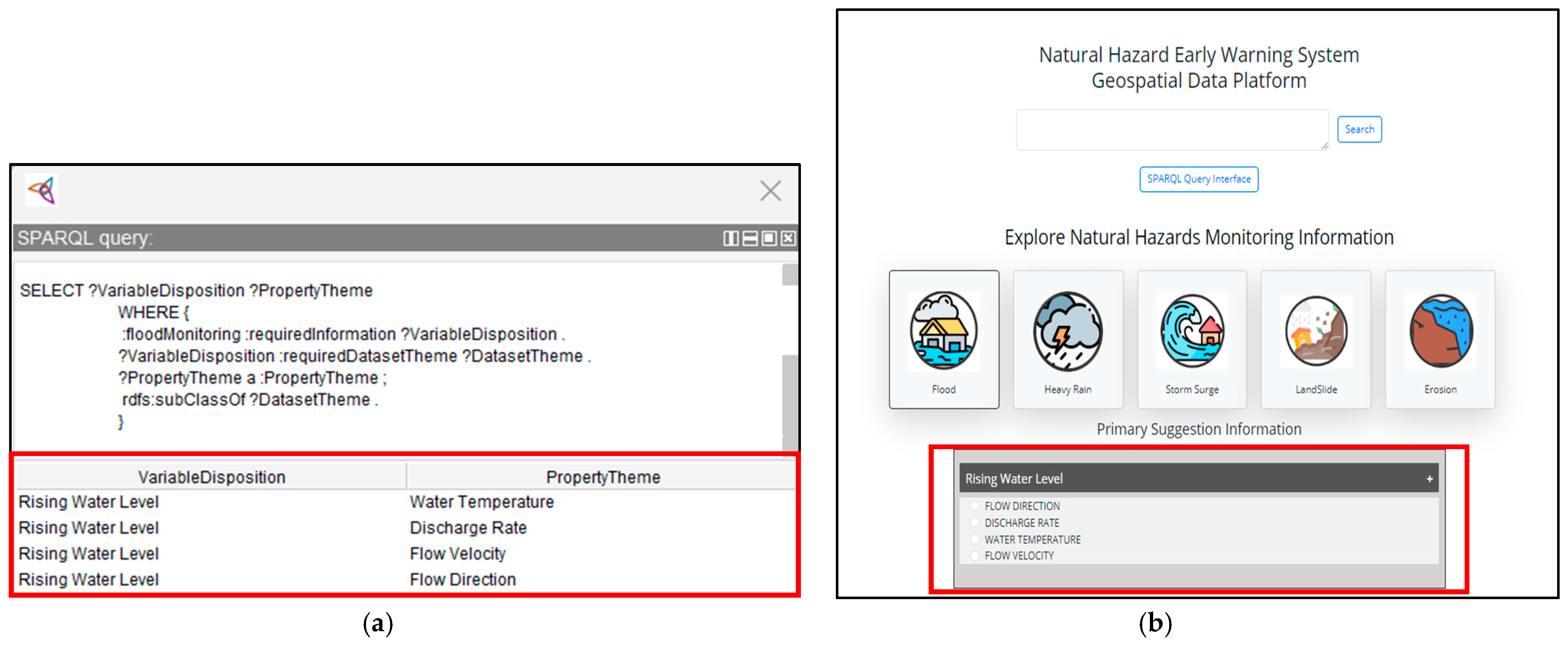
| Presence of River Systems and Lake Basins | Rivers/Streams Lakes | Rising Water Levels (Directly related to monitoring the flood) | Flow Direction Discharge Rate Water Temperature Flow Velocity |
| Existence of Wetlands and Low-Lying Areas | Wetlands Floodplains | Pre-Storm Wind Patterns (Related to monitoring the triggering event of Storm Surges) | Atmospheric Winds Air Pressure Sea Surface Temperature |
| Existence of Glacial Deposits and Varied Topography | Glacial Deposits Topography | Seasonal and Daily Temperature Fluctuations (Related to monitoring the triggering event of Rapid Snowmelt) | Surface Air Temperature Solar Radiation |
| Presence of Rocky Terrains and Minimal Soil Cover | Terrain Soil Texture | Snowmelt and Ice Breakup (Related to monitoring the triggering events of Rapid Snowmelt/Ice Jams) | Surface Air Temperature River Ice Thickness Ice Sheets/Ice Shelves |
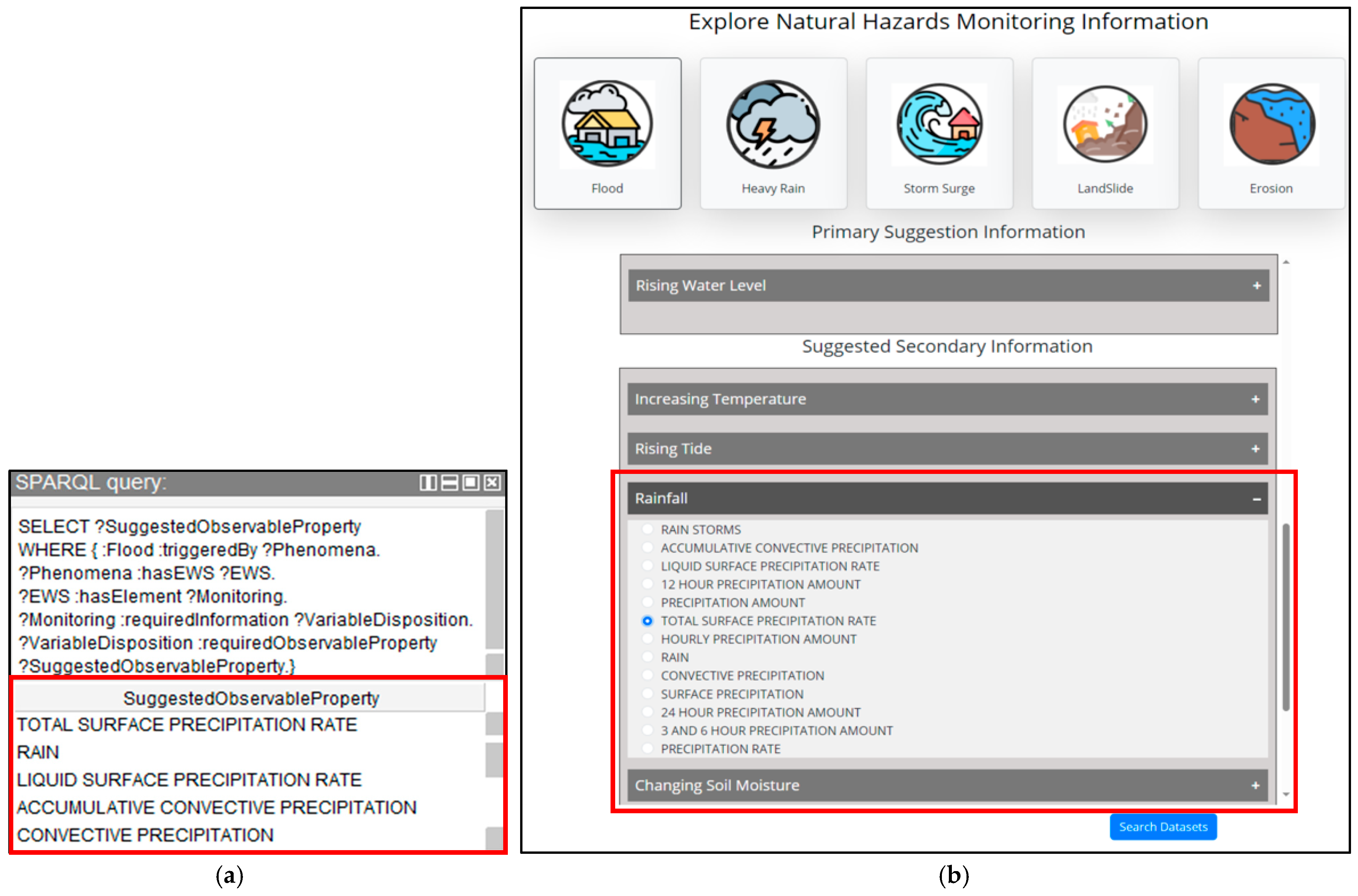
| Continuous Permafrost Zones | Permafrost | Precipitation (Related to monitoring the triggering event of Heavy Rainfall) | Precipitation Accumulated Precipitation |
| Thawing Permafrost Areas | Permafrost Degradation | Seasonal Precipitation Shifts (Related to monitoring the triggering events of Heavy Rainfall/Ice Jams) | Precipitation Surface Air Temperature |
| Sparse Tundra Vegetation | Tundra | Snowpack Variability (Related to monitoring the triggering events of Heavy Rainfall/Ice Jams) | Snow Cover Snow Water Equivalent |
| Changes in Vegetation Cover | Vegetation Cover Land Cover | Fall Rainfall Intensity and Freeze-up Timing (Related to the triggering event of Ice Jams) | Precipitation Surface Air Temperature Ice Formation |
Disclaimer/Publisher’s Note: The statements, opinions and data contained in all publications are solely those of the individual author(s) and contributor(s) and not of MDPI and/or the editor(s). MDPI and/or the editor(s) disclaim responsibility for any injury to people or property resulting from any ideas, methods, instructions or products referred to in the content. |
© 2025 by the authors. Published by MDPI on behalf of the International Society for Photogrammetry and Remote Sensing. Licensee MDPI, Basel, Switzerland. This article is an open access article distributed under the terms and conditions of the Creative Commons Attribution (CC BY) license (https://creativecommons.org/licenses/by/4.0/).
Share and Cite
Vahdat, A.; Badard, T.; Pouliot, J. Development of an Ontology-Based Framework to Enhance Geospatial Data Discovery and Selection in Geoportals for Natural-Hazard Early Warning Systems. ISPRS Int. J. Geo-Inf. 2025, 14, 369. https://doi.org/10.3390/ijgi14100369
Vahdat A, Badard T, Pouliot J. Development of an Ontology-Based Framework to Enhance Geospatial Data Discovery and Selection in Geoportals for Natural-Hazard Early Warning Systems. ISPRS International Journal of Geo-Information. 2025; 14(10):369. https://doi.org/10.3390/ijgi14100369
Chicago/Turabian StyleVahdat, Amirhossein, Thierry Badard, and Jacynthe Pouliot. 2025. "Development of an Ontology-Based Framework to Enhance Geospatial Data Discovery and Selection in Geoportals for Natural-Hazard Early Warning Systems" ISPRS International Journal of Geo-Information 14, no. 10: 369. https://doi.org/10.3390/ijgi14100369
APA StyleVahdat, A., Badard, T., & Pouliot, J. (2025). Development of an Ontology-Based Framework to Enhance Geospatial Data Discovery and Selection in Geoportals for Natural-Hazard Early Warning Systems. ISPRS International Journal of Geo-Information, 14(10), 369. https://doi.org/10.3390/ijgi14100369


