


Leveraging Transfer Learning and U-Nets Method for Improved Gap Filling in Himawari Sea Surface Temperature Data Adjacent to Taiwan


Abstract
1. Introduction
2. Data and Methods
2.1. Data
2.1.1. In Situ Buoy Observation
2.1.2. Himawari-8/9 Satellite Data
2.1.3. Typhoon Dataset
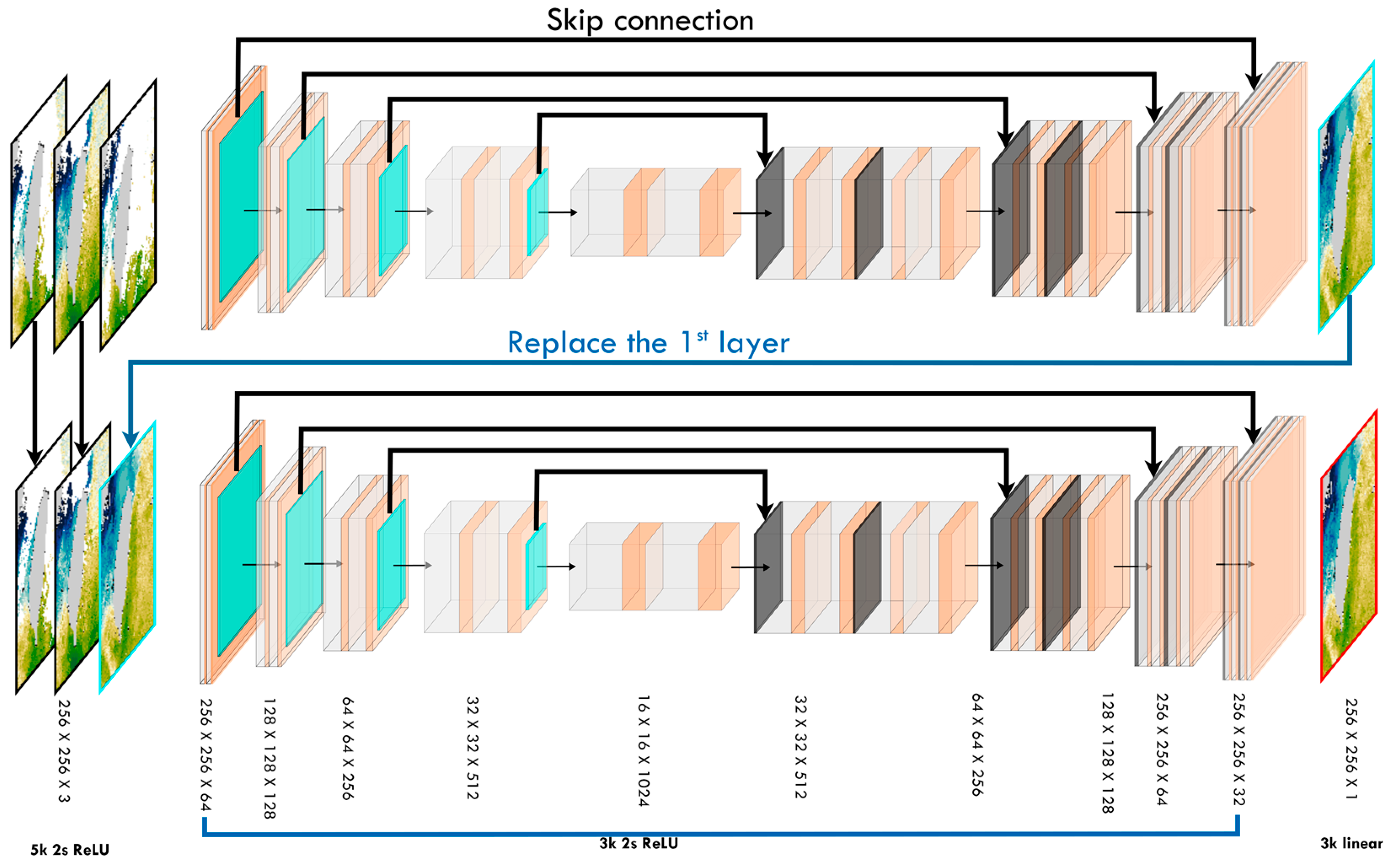
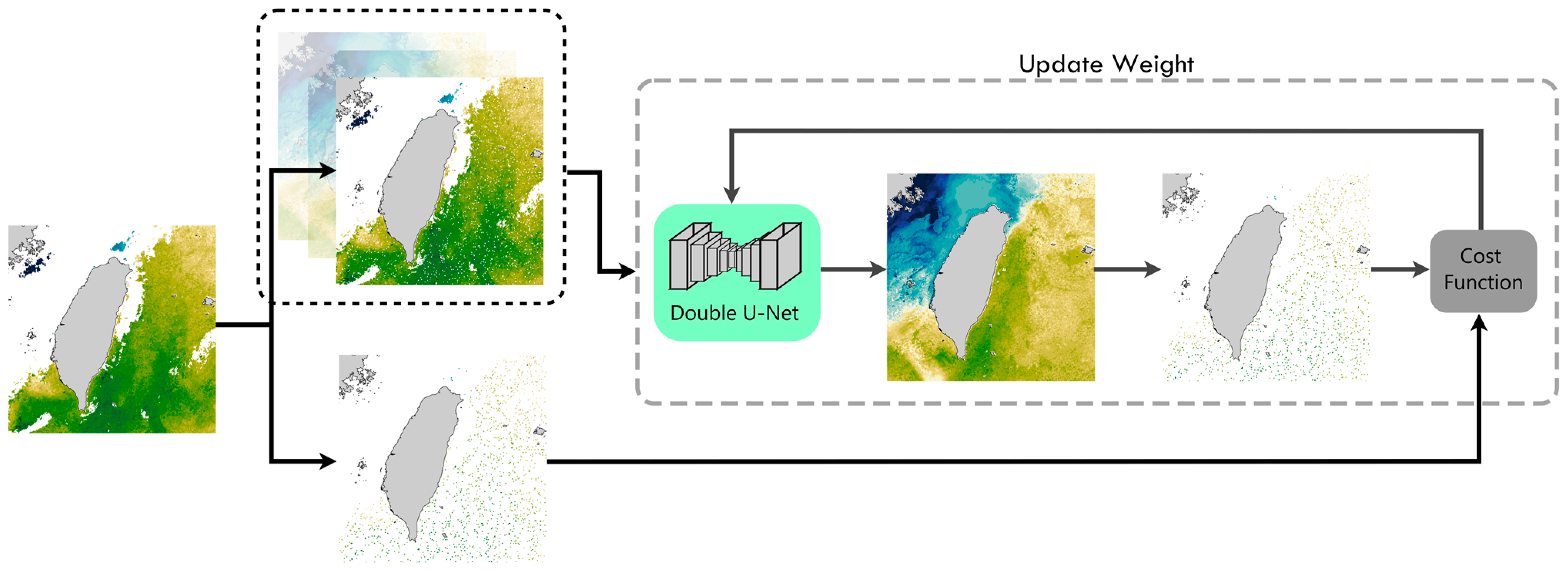
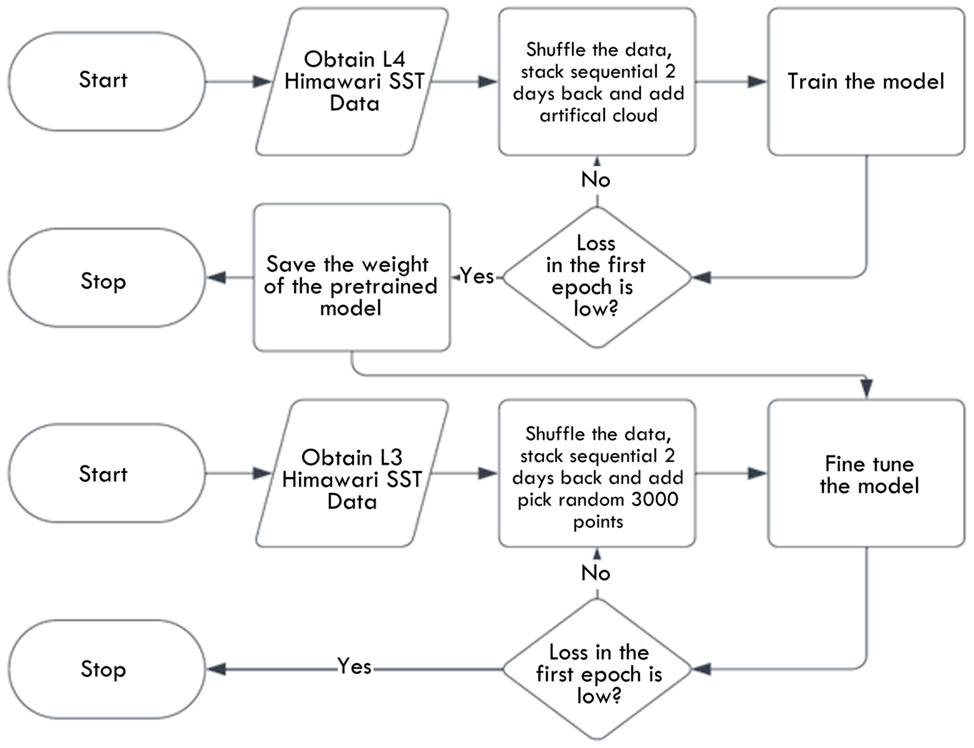
2.2. Data Filling of Double U-Net Architecture
3. Results
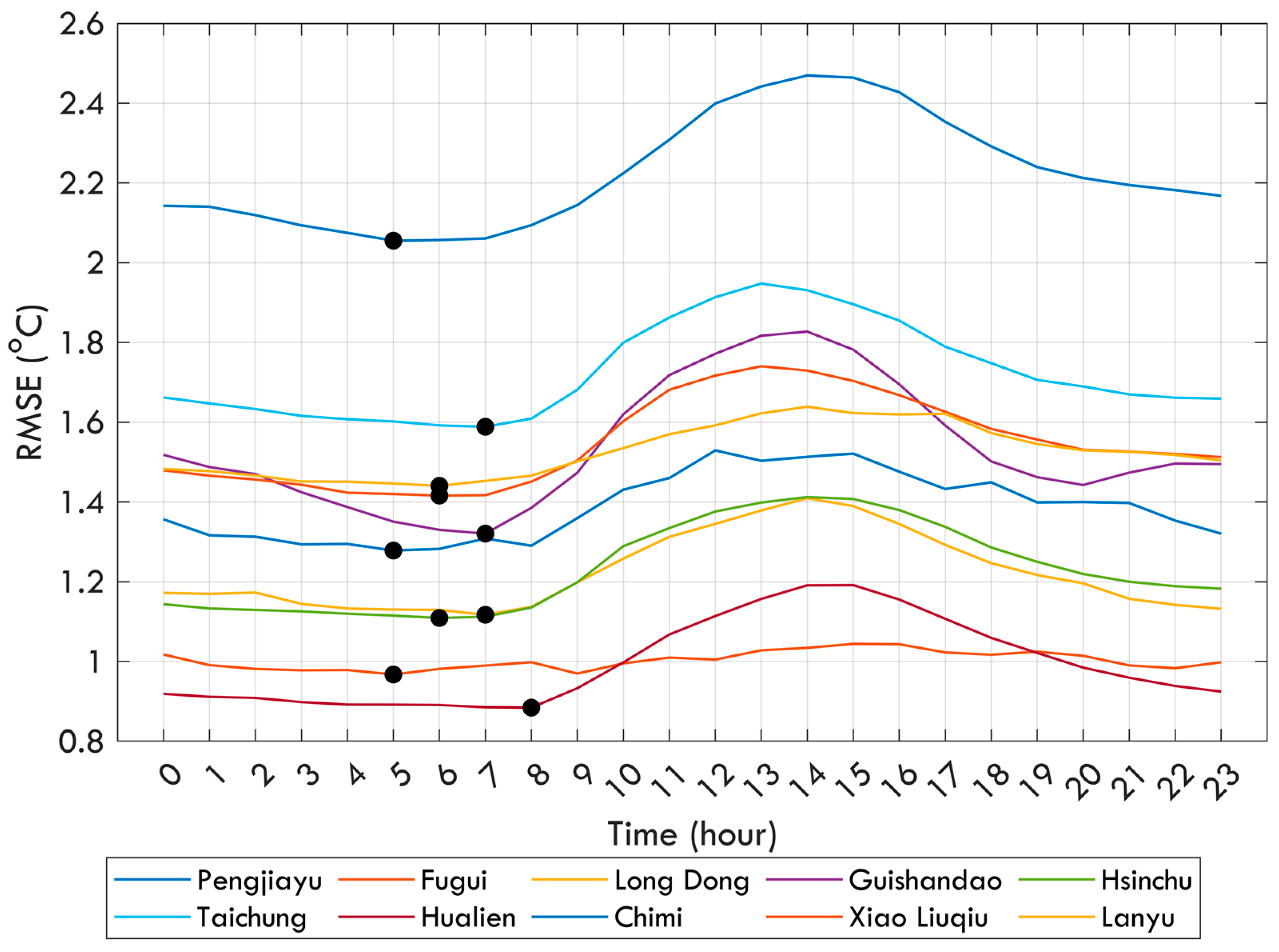
3.1. Evaluation of Filling Capabilities of Double U-Net and DINEOF Methods
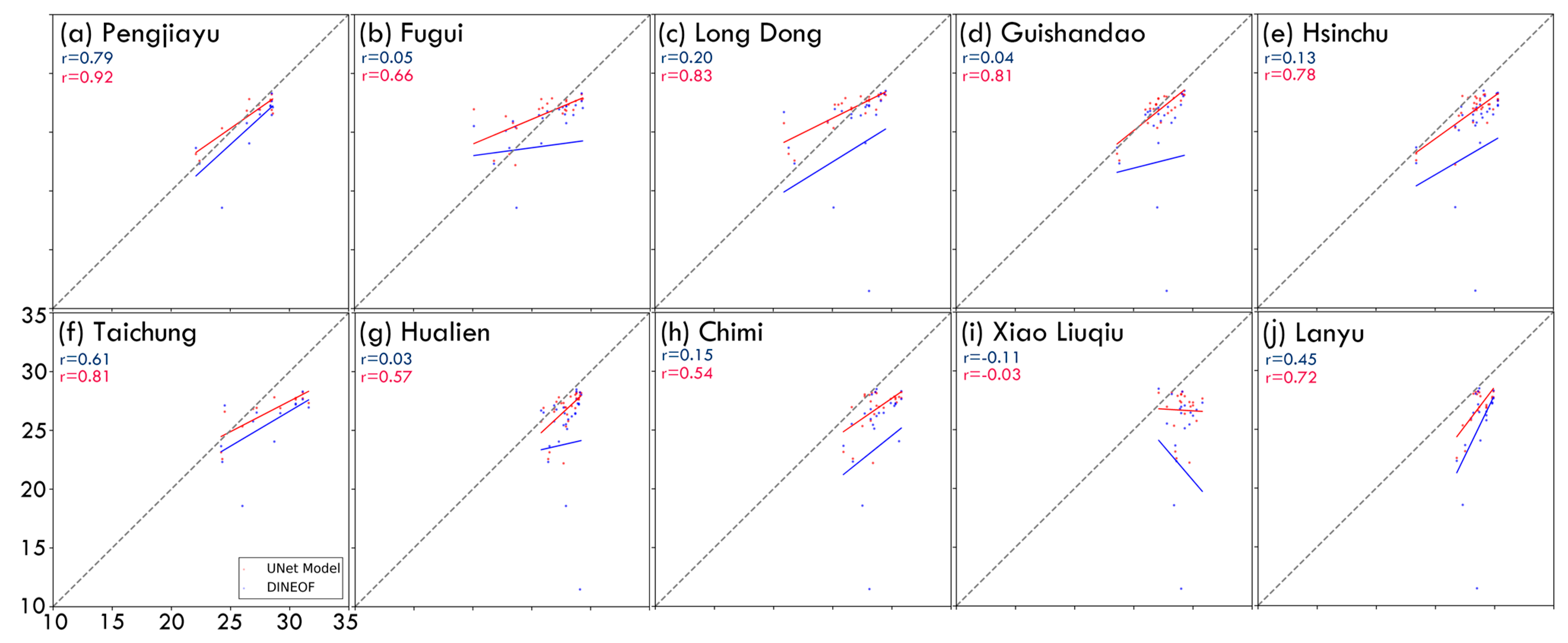
3.1.1. Comparison with Buoy Data
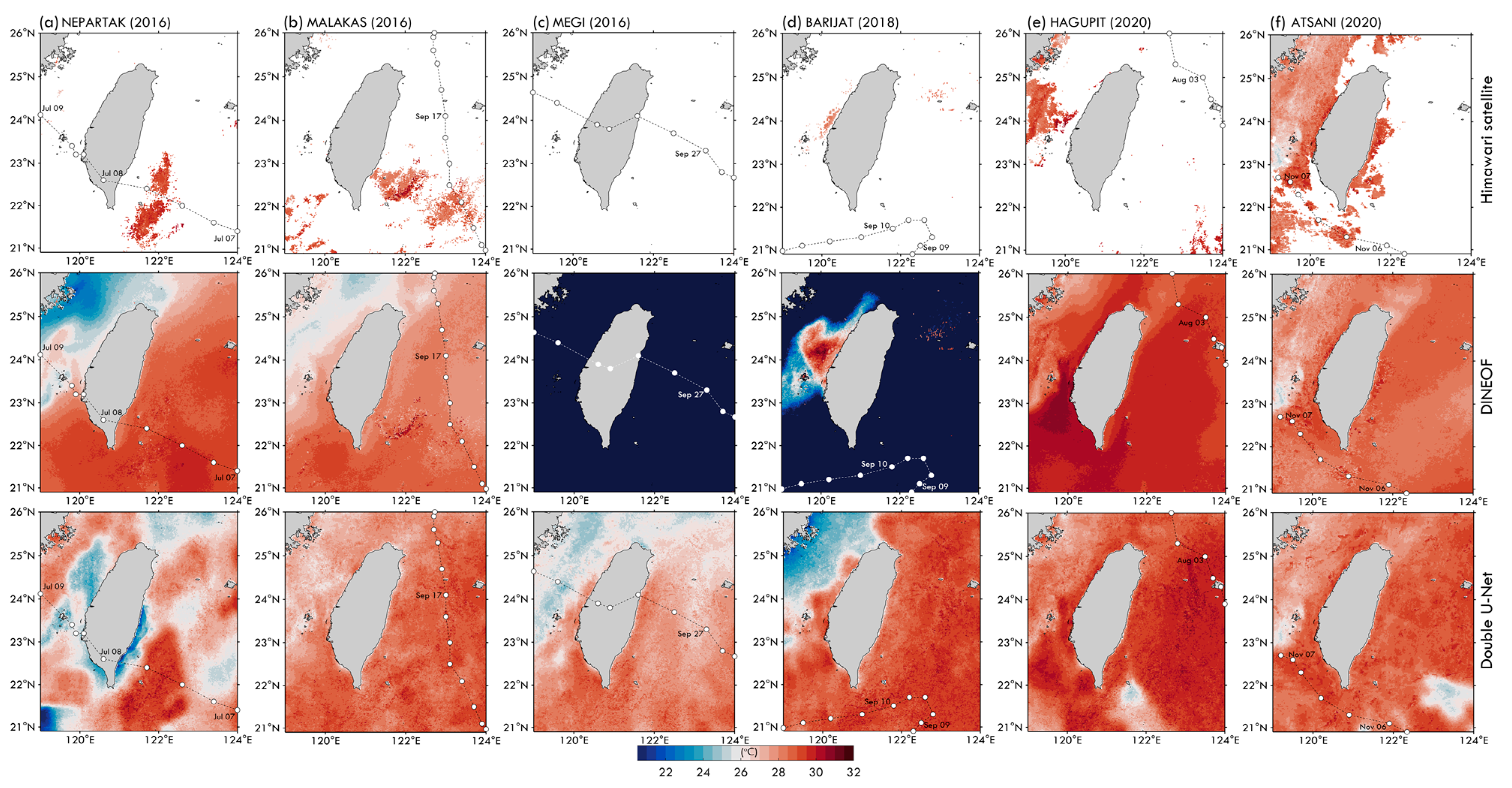
3.1.2. The Challenge of Filling in Data When a Typhoon Passes through
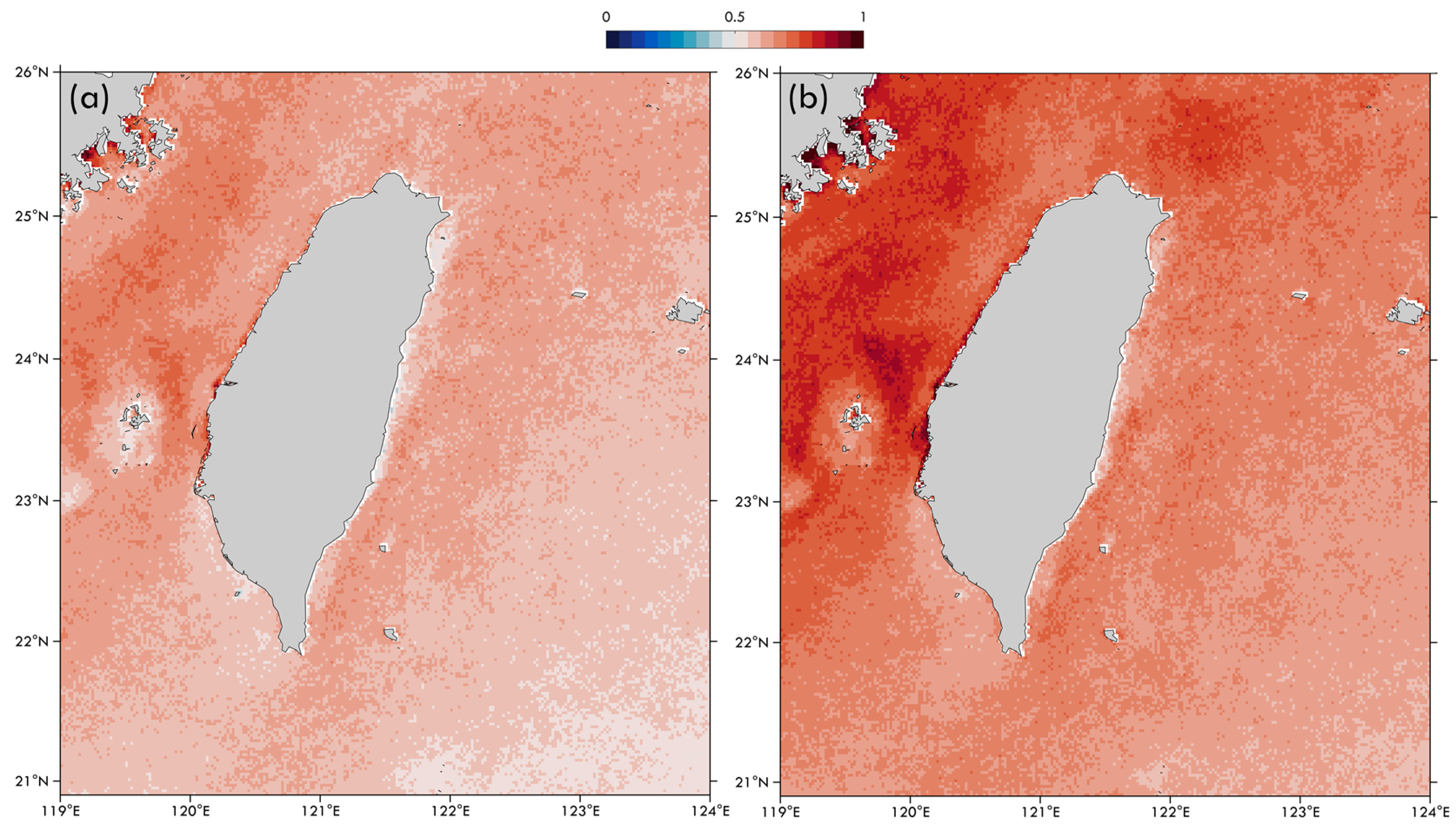
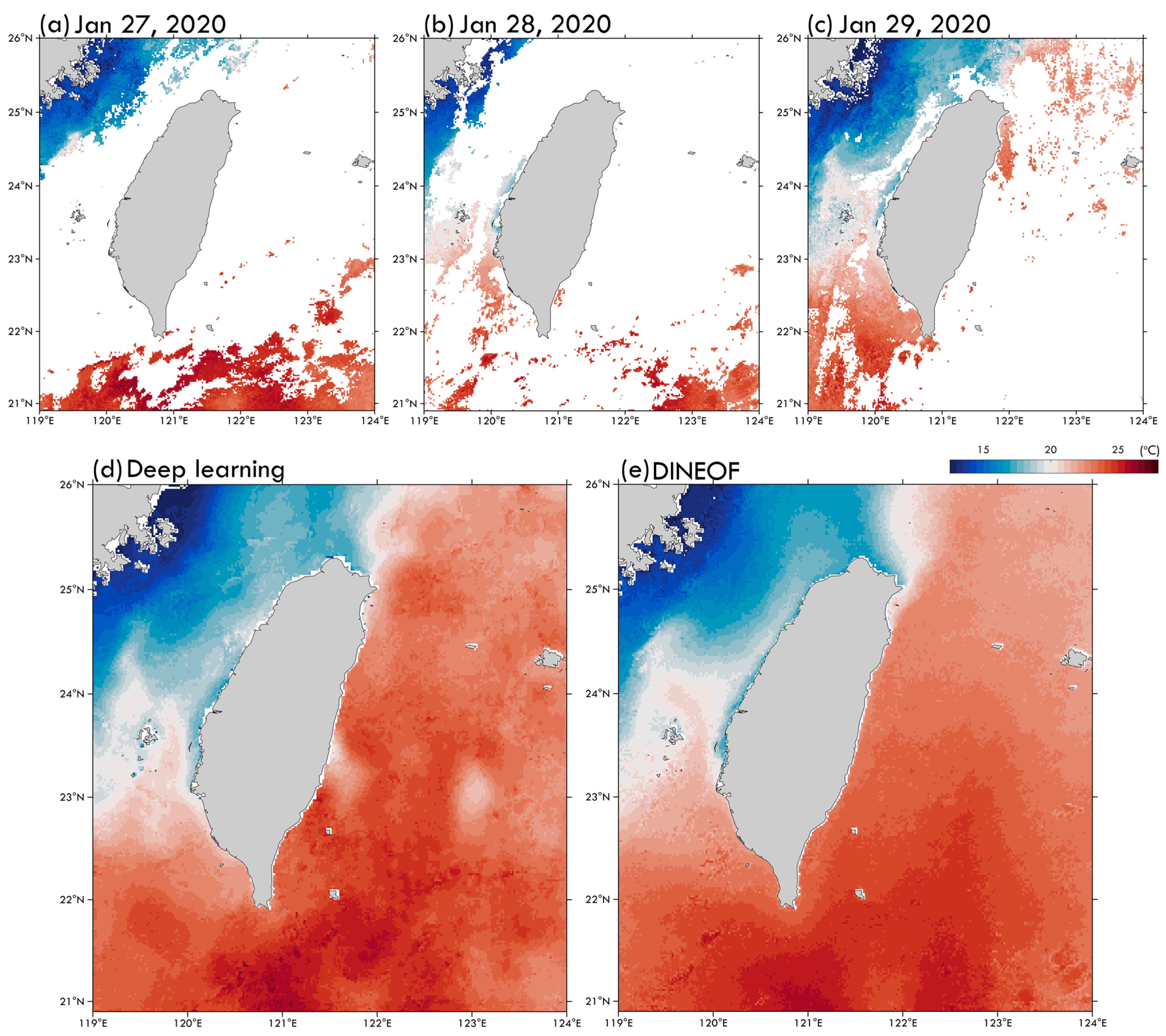
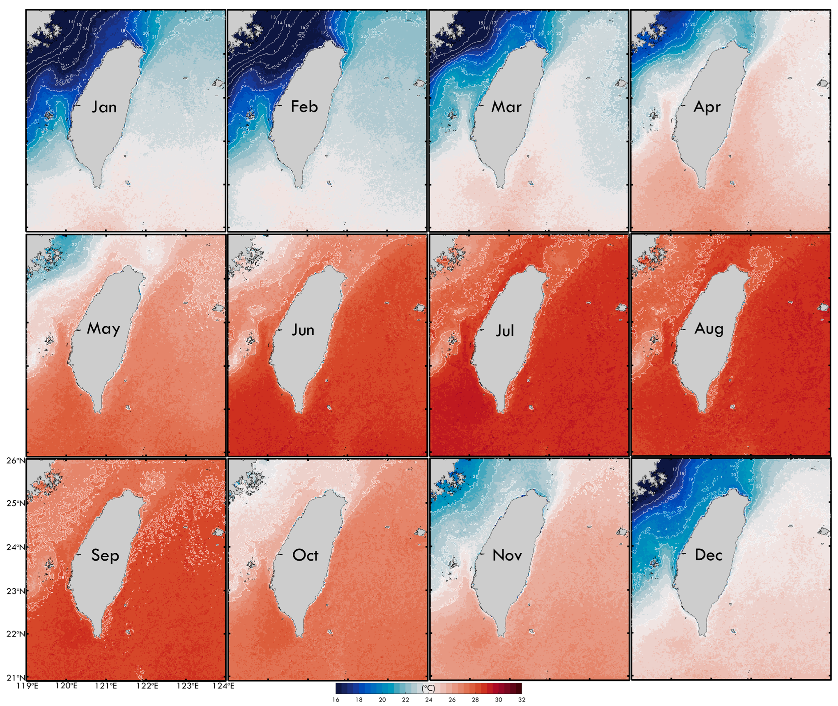
3.2. Spatial Patterns of Gap-Filled SST from Daily to Monthly Scale
4. Discussion
5. Conclusions
Author Contributions
Funding
Data Availability Statement
Acknowledgments
Conflicts of Interest
References
- Merchant, C.J.; Block, T.; Corlett, G.K.; Embury, O.; Mittaz, J.P.; Mollard, J.D. Harmonization of space-borne infra-red sensors measuring sea surface temperature. Remote Sens. 2020, 12, 1048. [Google Scholar] [CrossRef]
- Minnett, P.J.; Alvera-Azcárate, A.; Chin, T.M.; Corlett, G.K.; Gentemann, C.L.; Karagali, I.; Li, X.; Marsouin, A.; Marullo, S.; Maturi, E.; et al. Half a century of satellite remote sensing of sea-surface temperature. Remote Sens. Environ. 2019, 233, 111366. [Google Scholar] [CrossRef]
- Jia, X.; Ji, Q.; Han, L.; Liu, Y.; Han, G.; Lin, X. Prediction of sea surface temperature in the East China Sea based on LSTM neural network. Remote Sens. 2022, 14, 3300. [Google Scholar] [CrossRef]
- Zhang, R. On the persistence and coherence of subpolar sea surface temperature and salinity anomalies associated with the Atlantic multidecadal variability. Geophys. Res. Lett. 2017, 44, 7865–7875. [Google Scholar] [CrossRef]
- Long, A.P.; Haberlin, D.; Lyashevska, O.; Brophy, D.; O’Hea, B.; O’Donnell, C.; Scarrott, R.G.; Lawton, C.; Doyle, T.K. Interannual variability of gelatinous mesozooplankton in a temperate shelf sea: Greater abundance coincides with cooler sea surface temperatures. ICES J. Mar. Sci. 2021, 78, 1372–1385. [Google Scholar] [CrossRef]
- Callejas, I.A.; Osborn, K.; Lee, C.; Mishra, D.R.; Auil Gomez, N.; Carrias, A.; Cherrington, E.A.; Griffin, R.; Rosado, A.; Rosado, S.; et al. A GEE toolkit for water quality monitoring from 2002 to 2022 in support of SDG 14 and coral health in marine protected areas in Belize. Front. Remote Sens. 2022, 3, 1020184. [Google Scholar] [CrossRef]
- Quiring, K.; Carroll, G.; Champion, C.; Heymann, E.W.; Harcourt, R. The diet of greater crested terns off southeast Australia varies with breeding stage and sea surface temperature. Mar. Biol. 2021, 168, 143. [Google Scholar] [CrossRef]
- De, K.; Nanajkar, M.; Arora, M.; Nithyanandan, M.; Mote, S.; Ingole, B. Application of remotely sensed sea surface temperature for assessment of recurrent coral bleaching (2014–2019) impact on a marginal coral ecosystem. Geocarto Int. 2022, 37, 4483–4508. [Google Scholar] [CrossRef]
- Quartly, G.D.; Srokosz, M.A. SST observations of the Agulhas and East Madagascar retroflections by the TRMM Microwave Imager. J. Phys. Oceanogr. 2002, 32, 1585–1592. [Google Scholar] [CrossRef]
- Schumann GJ, P. Grand challenges in microwave remote sensing. Front. Remote Sens. 2020, 1, 603650. [Google Scholar] [CrossRef]
- Mavrovic, A.; Sonnentag, O.; Lemmetyinen, J.; Baltzer, J.L.; Kinnard, C.; Roy, A. Reviews and syntheses: Recent advances in microwave remote sensing in support of terrestrial carbon cycle science in Arctic–boreal regions. Biogeosciences 2023, 20, 2941–2970. [Google Scholar] [CrossRef]
- Wick, G.A.; Bates, J.J.; Scott, D.J. Satellite and skin-layer effects on the accuracy of sea surface temperature measurements from the GOES satellites. J. Atmos. Ocean. Technol. 2002, 19, 1834–1848. [Google Scholar] [CrossRef]
- Merchant, C.J.; Embury, O.; Bulgin, C.E.; Block, T.; Corlett, G.K.; Fiedler, E.; Good, S.A.; Mittaz, J.; Rayner, N.A.; Berry, D.; et al. Satellite-based time-series of sea-surface temperature since 1981 for climate applications. Sci. Data 2019, 6, 223. [Google Scholar] [CrossRef] [PubMed]
- Cao, M.; Mao, K.; Yan, Y.; Shi, J.; Wang, H.; Xu, T.; Fang, S.; Yuan, Z. A new global gridded sea surface temperature data product based on multisource data. Earth Syst. Sci. Data 2021, 13, 2111–2134. [Google Scholar] [CrossRef]
- Jääskeläinen, E.; Manninen, T.; Hakkarainen, J.; Tamminen, J. Filling gaps of black-sky surface albedo of the Arctic sea ice using gradient boosting and brightness temperature data. Int. J. Appl. Earth Obs. Geoinf. 2022, 107, 102701. [Google Scholar] [CrossRef]
- Jung, S.; Yoo, C.; Im, J. High-resolution seamless daily sea surface temperature based on satellite data fusion and machine learning over Kuroshio Extension. Remote Sens. 2022, 14, 575. [Google Scholar] [CrossRef]
- Davis, L.L.; Thompson, D.W.; Kennedy, J.J.; Kent, E.C. The importance of unresolved biases in twentieth-century sea surface temperature observations. Bull. Am. Meteorol. Soc. 2019, 100, 621–629. [Google Scholar] [CrossRef]
- O’carroll, A.G.; Armstrong, E.M.; Beggs, H.M.; Bouali, M.; Casey, K.S.; Corlett, G.K.; Dash, P.; Donlon, C.J.; Gentemann, C.L.; Høyer, J.L.; et al. Observational needs of sea surface temperature. Front. Mar. Sci. 2019, 6, 420. [Google Scholar] [CrossRef]
- Parker, D.E.; Folland, C.K.; Jackson, M. Marine surface temperature: Observed variations and data requirements. Clim. Chang. 1995, 31, 559–600. [Google Scholar] [CrossRef]
- Sukhotin, A.; Berger, V. Long-term monitoring studies as a powerful tool in marine ecosystem research. Hydrobiologia 2013, 706, 1–9. [Google Scholar] [CrossRef]
- Taylor, S.P.; Haywood, A.M.; Valdes, P.J.; Sellwood, B.W. An evaluation of two spatial interpolation techniques in global sea-surface temperature reconstructions: Last Glacial Maximum and Pliocene case studies. Quat. Sci. Rev. 2004, 23, 1041–1051. [Google Scholar] [CrossRef]
- Kusuma, D.W.; Murdimanto, A.; Sukresno, B.; Jatisworo, D. Comparison of interpolation methods for sea surface temperature data. J. Fish. Mar. Res. 2018, 2, 103–115. [Google Scholar] [CrossRef]
- Zhang, Y.; Feng, M.; Zhang, W.; Wang, H.; Wang, P. A Gaussian process regression-based sea surface temperature interpolation algorithm. J. Oceanol. Limnol. 2021, 39, 1211–1221. [Google Scholar] [CrossRef]
- Urquhart, E.A.; Hoffman, M.J.; Murphy, R.R.; Zaitchik, B.F. Geospatial interpolation of MODIS-derived salinity and temperature in the Chesapeake Bay. Remote Sens. Environ. 2013, 135, 167–177. [Google Scholar] [CrossRef]
- Schneider, T. Analysis of incomplete climate data: Estimation of mean values and covariance matrices and imputation of missing values. J. Clim. 2001, 14, 853–871. [Google Scholar] [CrossRef]
- Beckers, J.M.; Rixen, M. EOF calculations and data filling from incomplete oceanographic datasets. J. Atmos. Ocean. Technol. 2003, 20, 1839–1856. [Google Scholar] [CrossRef]
- Beckers, J.M.; Barth, A.; Alvera-Azcárate, A. DINEOF reconstruction of clouded images including error maps–application to the Sea-Surface Temperature around Corsican Island. Ocean. Sci. 2006, 2, 183–199. [Google Scholar] [CrossRef]
- Alvera-Azcárate, A.; Barth, A.; Sirjacobs, D.; Beckers, J.M. Enhancing temporal correlations in EOF expansions for the reconstruction of missing data using DINEOF. Ocean. Sci. 2009, 5, 475–485. [Google Scholar] [CrossRef]
- Jouini, M.; Lévy, M.; Crépon, M.; Thiria, S. Reconstruction of satellite chlorophyll images under heavy cloud coverage using a neural classification method. Remote Sens. Environ. 2013, 131, 232–246. [Google Scholar] [CrossRef]
- Chen, S.; Hu, C.; Barnes, B.B.; Xie, Y.; Lin, G.; Qiu, Z. Improving ocean color data coverage through machine learning. Remote Sens. Environ. 2019, 222, 286–302. [Google Scholar] [CrossRef]
- Stock, A.; Subramaniam, A.; Van Dijken, G.L.; Wedding, L.M.; Arrigo, K.R.; Mills, M.M.; Cameron, M.A.; Micheli, F. Comparison of cloud-filling algorithms for marine satellite data. Remote Sens. 2020, 12, 3313. [Google Scholar] [CrossRef]
- Krasnopolsky, V.; Nadiga, S.; Mehra, A.; Bayler, E.; Behringer, D. Neural networks technique for filling gaps in satellite measurements: Application to ocean color observations. Comput. Intell. Neurosci. 2016, 2016, 6156513. [Google Scholar] [CrossRef] [PubMed]
- Konik, M.; Kowalewski, M.; Bradtke, K.; Darecki, M. The operational method of filling information gaps in satellite imagery using numerical models. Int. J. Appl. Earth Obs. Geoinf. 2019, 75, 68–82. [Google Scholar] [CrossRef]
- Buttlar, J.V.; Zscheischler, J.; Mahecha, M.D. An extended approach for spatiotemporal gapfilling: Dealing with large and systematic gaps in geoscientific datasets. Nonlinear Process. Geophys. 2014, 21, 203–215. [Google Scholar] [CrossRef]
- Yang, J.; Huo, J.; He, J.; Xiao, T.; Chen, D.; Li, Y. A DBULSTM-Adaboost Model for Sea Surface Temperature Prediction. PeerJ Comput. Sci. 2022, 8, e1095. [Google Scholar] [CrossRef]
- Chan, D. Combining Statistical, Physical, and Historical Evidence to Improve Historical Sea-Surface Temperature Records. Harv. Data Sci. Rev. 2021, 3. [Google Scholar] [CrossRef]
- Barth, A.; Alvera-Azcárate, A.; Licer, M.; Beckers, J.M. DINCAE 1.0: A convolutional neural network with error estimates to reconstruct sea surface temperature satellite observations. Geosci. Model Dev. 2020, 13, 1609–1622. [Google Scholar] [CrossRef]
- Patil, K.R.; Iiyama, M. Deep learning models to predict Sea surface temperature in tohoku region. IEEE Access 2022, 10, 40410–40418. [Google Scholar] [CrossRef]
- Baker, S.; Huang, Z.; Philippa, B. Lightweight Neural Network For Spatiotemporal Filling of Data Gaps in Sea Surface Temperature Images. IEEE Trans. Geosci. Remote Sens. 2023, 61, 4204310. [Google Scholar] [CrossRef]
- Chai, X.; Gu, H.; Li, F.; Duan, H.; Hu, X.; Lin, K. Deep learning for irregularly and regularly missing data reconstruction. Sci. Rep. 2020, 10, 3302. [Google Scholar] [CrossRef]
- Hsu, P.C.; Centurioni, L.; Shao, H.J.; Zheng, Q.; Lu, C.Y.; Hsu, T.W.; Tseng, R.S. Surface current variations and oceanic fronts in the southern East China Sea: Drifter experiments, coastal radar applications, and satellite observations. J. Geophys. Res. Ocean. 2021, 126, e2021JC017373. [Google Scholar] [CrossRef]
- Hsu, P.C.; Lee, H.J.; Lu, C.Y. Impacts of the Kuroshio and Tidal Currents on the Hydrological Characteristics of Yilan Bay, Northeastern Taiwan. Remote Sens. 2021, 13, 4340. [Google Scholar] [CrossRef]
- Hsu, P.C. Surface Current Variations and Hydrological Characteristics of the Penghu Channel in the Southeastern Taiwan Strait. Remote Sens. 2022, 14, 1816. [Google Scholar] [CrossRef]
- Knapp, K.R.; Kruk, M.C.; Levinson, D.H.; Diamond, H.J.; Neumann, C.J. The international best track archive for climate stewardship (IBTrACS) unifying tropical cyclone data. Bull. Am. Meteorol. Soc. 2010, 91, 363–376. [Google Scholar] [CrossRef]
- Hsu, P.C. Evaluation of Wind and Solar Insolation Influence on Ocean Near-Surface Temperature from In Situ Observations and the Geostationary Himawari-8 Satellite. Remote Sens. 2022, 14, 4975. [Google Scholar] [CrossRef]
- Lu, C.Y.; Hsu, P.C.; Zheng, Q.; Ho, C.R. Variations in flow patterns in the northern Taiwan Strait observed by satellite-tracked drifters. Remote Sens. 2022, 14, 2154. [Google Scholar] [CrossRef]
- Hsu, P.C.; Zheng, Q.; Lu, C.Y.; Cheng, K.H.; Lee, H.J.; Ho, C.R. Interaction of coastal countercurrent in I-Lan Bay with the Kuroshio northeast of Taiwan. Cont. Shelf Res. 2018, 171, 30–41. [Google Scholar] [CrossRef]
- Hsu, P.C.; Macagga RA, T.; Lu, C.Y.; Lo DY, J. Investigation of the Kuroshio-Coastal Current Interaction and Marine Heatwave Trends in the Coral Habitats of Northeastern Taiwan. Reg. Stud. Mar. Sci. 2024, 71, 103431. [Google Scholar] [CrossRef]


| Buoy | Co-Ordinates | Data Sample Number | |
|---|---|---|---|
| Lat | Lon | ||
| Pengjiayu | 25°37′13″ N | 122°04′06″ E | 400 |
| Fugui | 25°18′14″ N | 121°32′01″ E | 404 |
| Long Dong | 25°05′52″ N | 121°55′21″ E | 495 |
| Guishandao | 24°50′54″ N | 121°55′31″ E | 468 |
| Hsinchu | 24°45′47″ N | 120°50′37″ E | 257 |
| Taichung | 24°12′56″ N | 120°24′48″ E | 211 |
| Hualien | 24°01′54″ N | 121°37′55″ E | 481 |
| Chimi | 23°11′14″ N | 119°39′22″ E | 213 |
| Xiao Liuqiu | 22°19′00″ N | 120°22′24″ E | 166 |
| Lanyu | 22°04′31″ N | 121°34′58″ E | 301 |
| Buoy | Number of Samples | R | RMSE (°C) | ME (°C) | |||
|---|---|---|---|---|---|---|---|
| DINEOF | U-Net | DINEOF | U-Net | DINEOF | U-Net | ||
| Pengjiayu | 318 | 0.56 | 0.81 | 4.03 | 2.24 | –1.61 | –1.24 |
| Fugui | 1039 | 0.68 | 0.81 | 3.77 | 2.94 | –0.96 | –1.19 |
| Long Dong | 1065 | 0.62 | 0.84 | 3.79 | 1.84 | –1.23 | –0.58 |
| Guishandao | 1328 | 0.47 | 0.71 | 4.49 | 2.48 | –1.80 | –1.33 |
| Hsinchu | 804 | 0.63 | 0.88 | 4.90 | 3.19 | –1.80 | –2.21 |
| Taichung | 257 | 0.64 | 0.91 | 5.37 | 2.14 | –2.40 | –1.26 |
| Hualien | 1324 | 0.44 | 0.73 | 4.16 | 1.98 | –1.31 | –1.14 |
| Chimi | 549 | 0.47 | 0.86 | 6.83 | 2.21 | –3.62 | –1.73 |
| Xiao Liuqiu | 481 | 0.44 | 0.67 | 7.17 | 2.31 | –3.44 | –1.37 |
| Lanyu | 562 | 0.42 | 0.37 | 5.72 | 3.63 | –2.50 | –2.37 |
| Buoy | Number of Samples | R | RMSE (°C) | ME (°C) | |||
|---|---|---|---|---|---|---|---|
| DINEOF | U-Net | DINEOF | U-Net | DINEOF | U-Net | ||
| Pengjiayu | 13 | 0.79 | 0.92 | 2.02 | 0.98 | –1.21 | –0.22 |
| Fugui | 24 | 0.05 | 0.66 | 7.57 | 1.97 | –2.35 | 0.42 |
| Long Dong | 24 | 0.20 | 0.83 | 8.29 | 1.51 | –3.18 | 0.33 |
| Guishandao | 25 | 0.04 | 0.81 | 9.67 | 0.94 | –4.75 | –0.34 |
| Hsinchu | 31 | 0.13 | 0.78 | 9.22 | 1.90 | –5.08 | –1.56 |
| Taichung | 13 | 0.61 | 0.81 | 3.51 | 2.30 | –2.61 | –1.62 |
| Hualien | 29 | 0.03 | 0.57 | 8.23 | 1.76 | –4.10 | –1.16 |
| Chimi | 25 | 0.15 | 0.54 | 8.88 | 2.44 | –5.24 | –1.93 |
| Xiao Liuqiu | 22 | −0.11 | −0.03 | 11.68 | 3.18 | −7.37 | −2.45 |
| Lanyu | 19 | 0.45 | 0.72 | 5.08 | 2.15 | –3.46 | –1.82 |
Disclaimer/Publisher’s Note: The statements, opinions and data contained in all publications are solely those of the individual author(s) and contributor(s) and not of MDPI and/or the editor(s). MDPI and/or the editor(s) disclaim responsibility for any injury to people or property resulting from any ideas, methods, instructions or products referred to in the content. |
© 2024 by the authors. Licensee MDPI, Basel, Switzerland. This article is an open access article distributed under the terms and conditions of the Creative Commons Attribution (CC BY) license (https://creativecommons.org/licenses/by/4.0/).
Share and Cite
Putra, D.P.; Hsu, P.-C. Leveraging Transfer Learning and U-Nets Method for Improved Gap Filling in Himawari Sea Surface Temperature Data Adjacent to Taiwan. ISPRS Int. J. Geo-Inf. 2024, 13, 162. https://doi.org/10.3390/ijgi13050162
Putra DP, Hsu P-C. Leveraging Transfer Learning and U-Nets Method for Improved Gap Filling in Himawari Sea Surface Temperature Data Adjacent to Taiwan. ISPRS International Journal of Geo-Information. 2024; 13(5):162. https://doi.org/10.3390/ijgi13050162
Chicago/Turabian StylePutra, Dimas Pradana, and Po-Chun Hsu. 2024. "Leveraging Transfer Learning and U-Nets Method for Improved Gap Filling in Himawari Sea Surface Temperature Data Adjacent to Taiwan" ISPRS International Journal of Geo-Information 13, no. 5: 162. https://doi.org/10.3390/ijgi13050162
APA StylePutra, D. P., & Hsu, P.-C. (2024). Leveraging Transfer Learning and U-Nets Method for Improved Gap Filling in Himawari Sea Surface Temperature Data Adjacent to Taiwan. ISPRS International Journal of Geo-Information, 13(5), 162. https://doi.org/10.3390/ijgi13050162