

Two Decades of Land-Use Dynamics in an Urbanizing Tropical Watershed: Understanding the Patterns and Drivers


Abstract
:1. Introduction
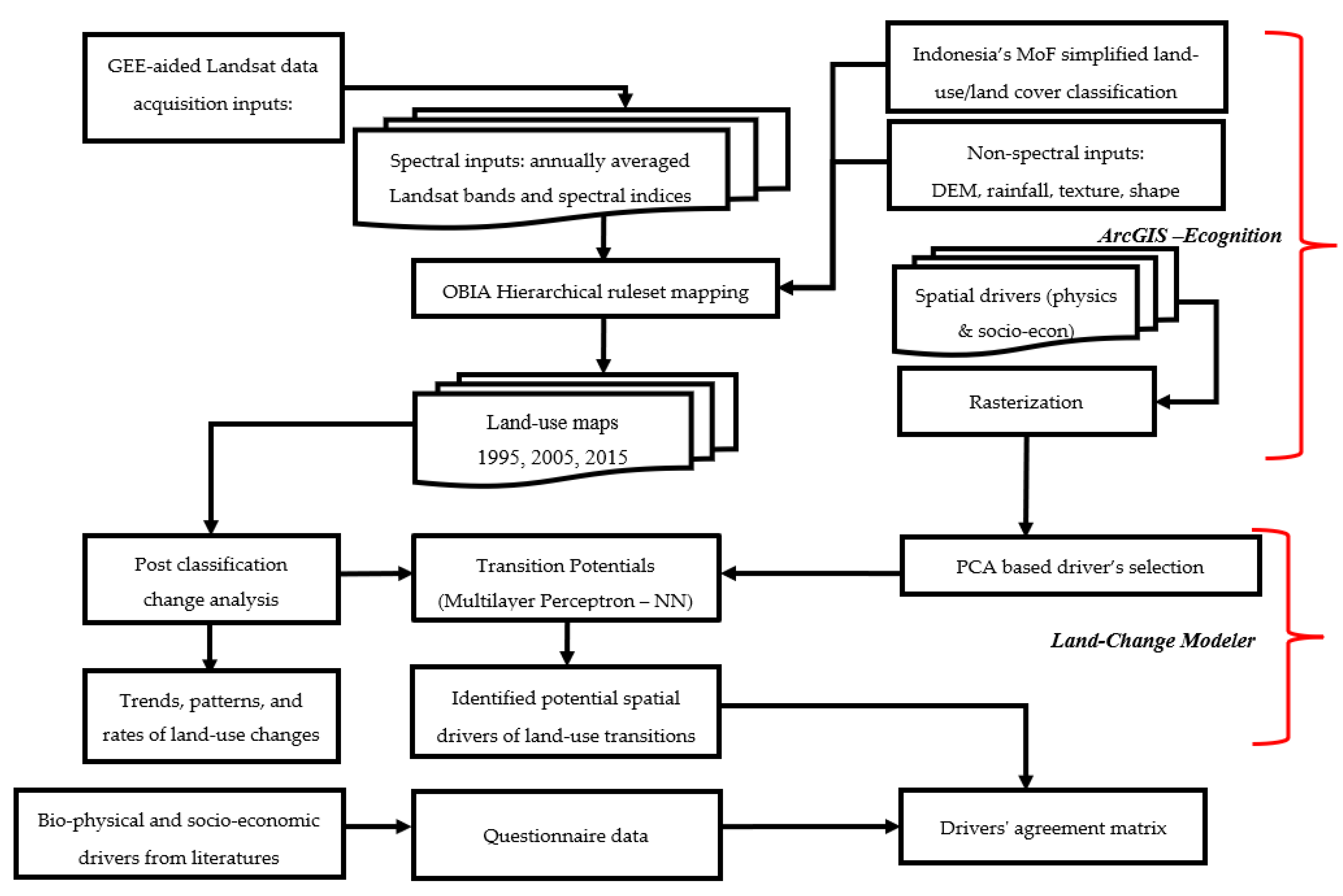
2. Materials and Methods
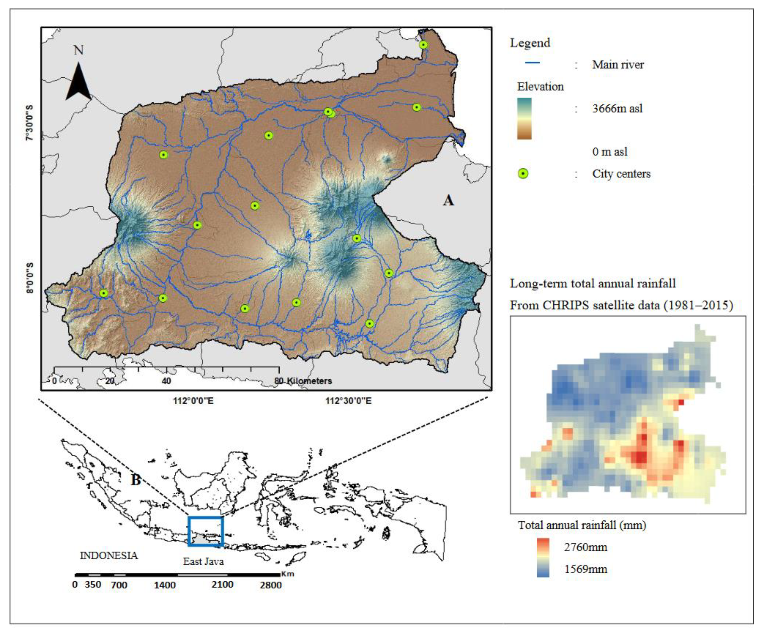
2.1. Study Area
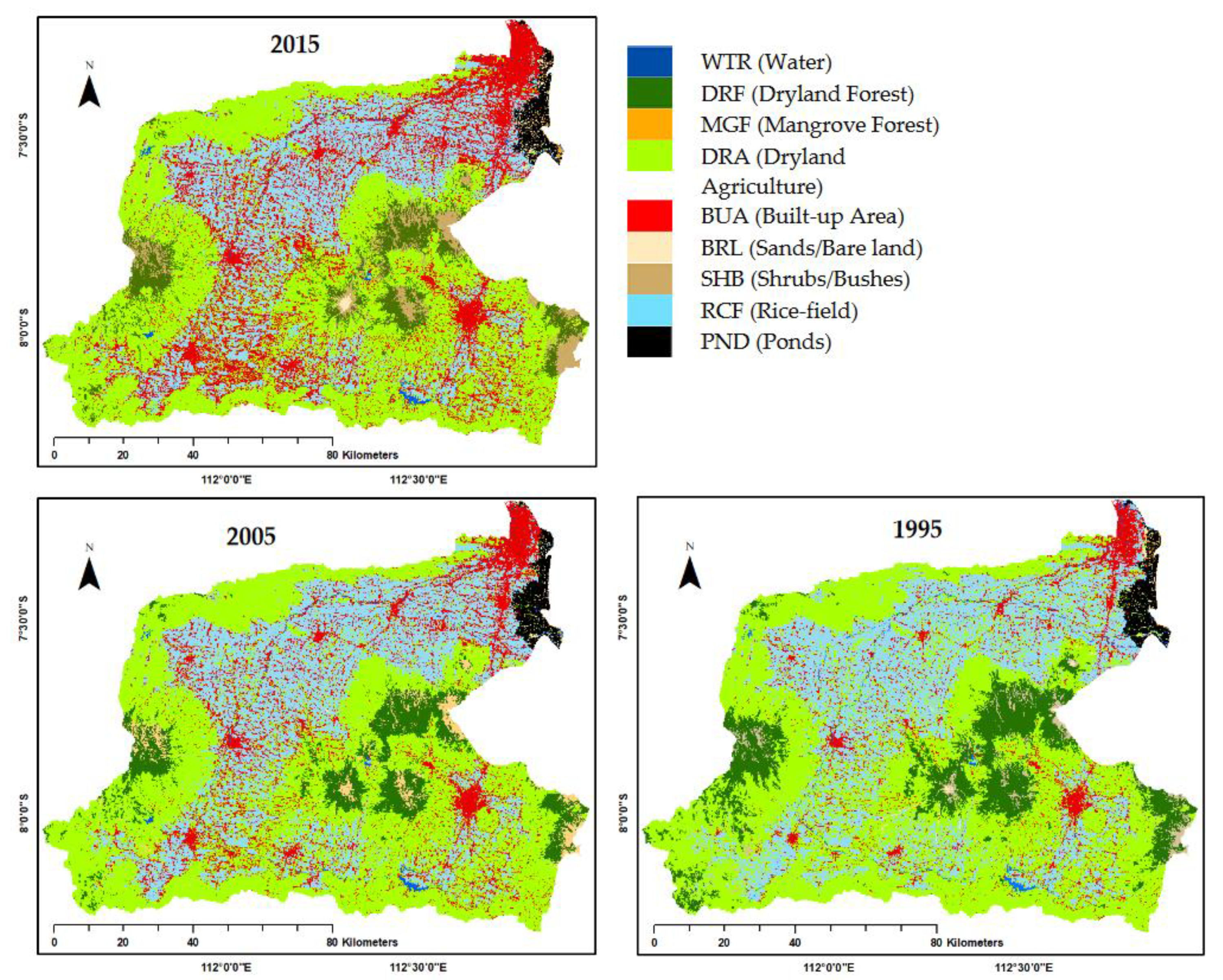
2.2. Land-Use Mapping Using Remote Sensing
2.3. Potential Land-Use Drivers from Spatial Modeling
2.4. Potential Land-Use Drivers from Questionnaires
3. Results
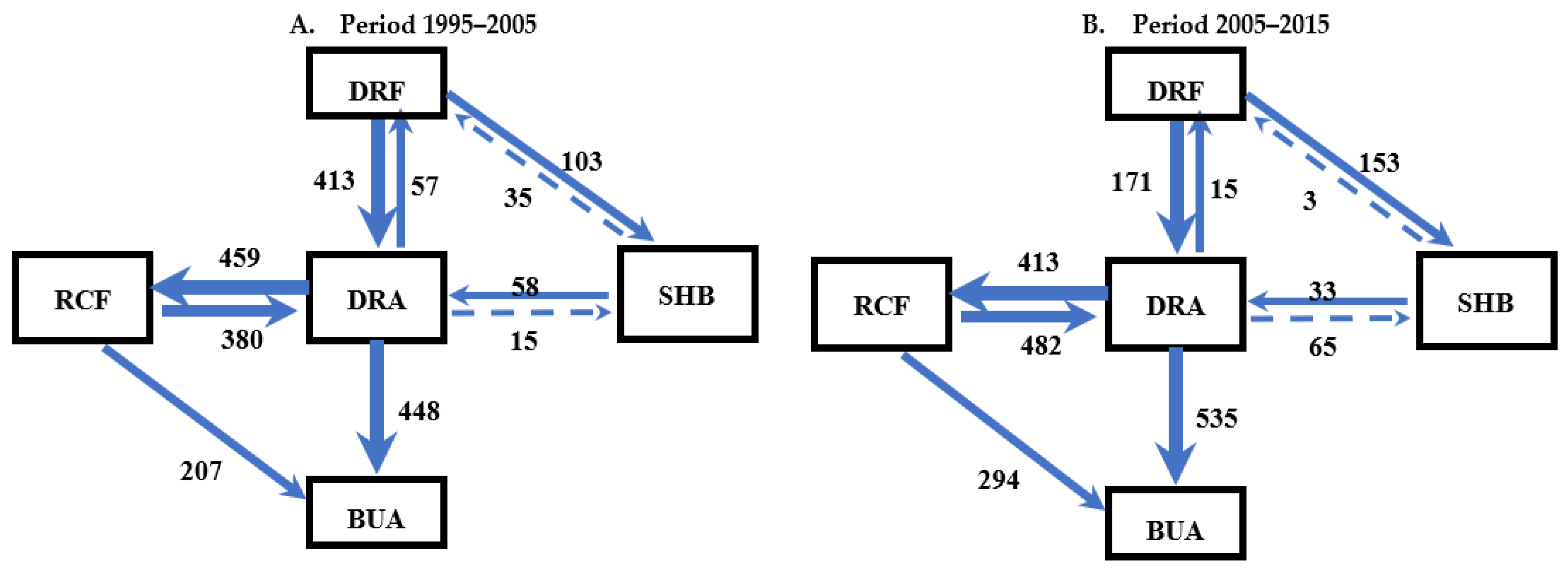
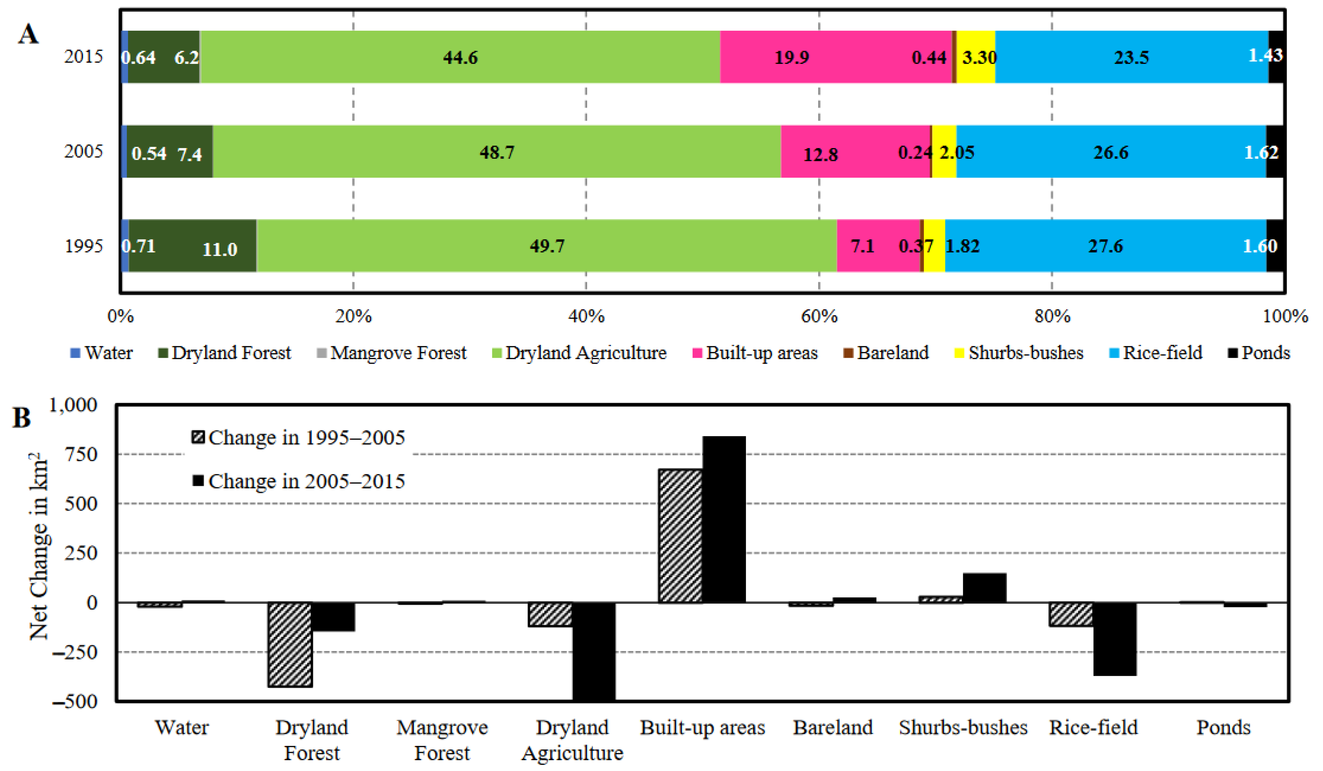
3.1. Land-Use Change Quantification
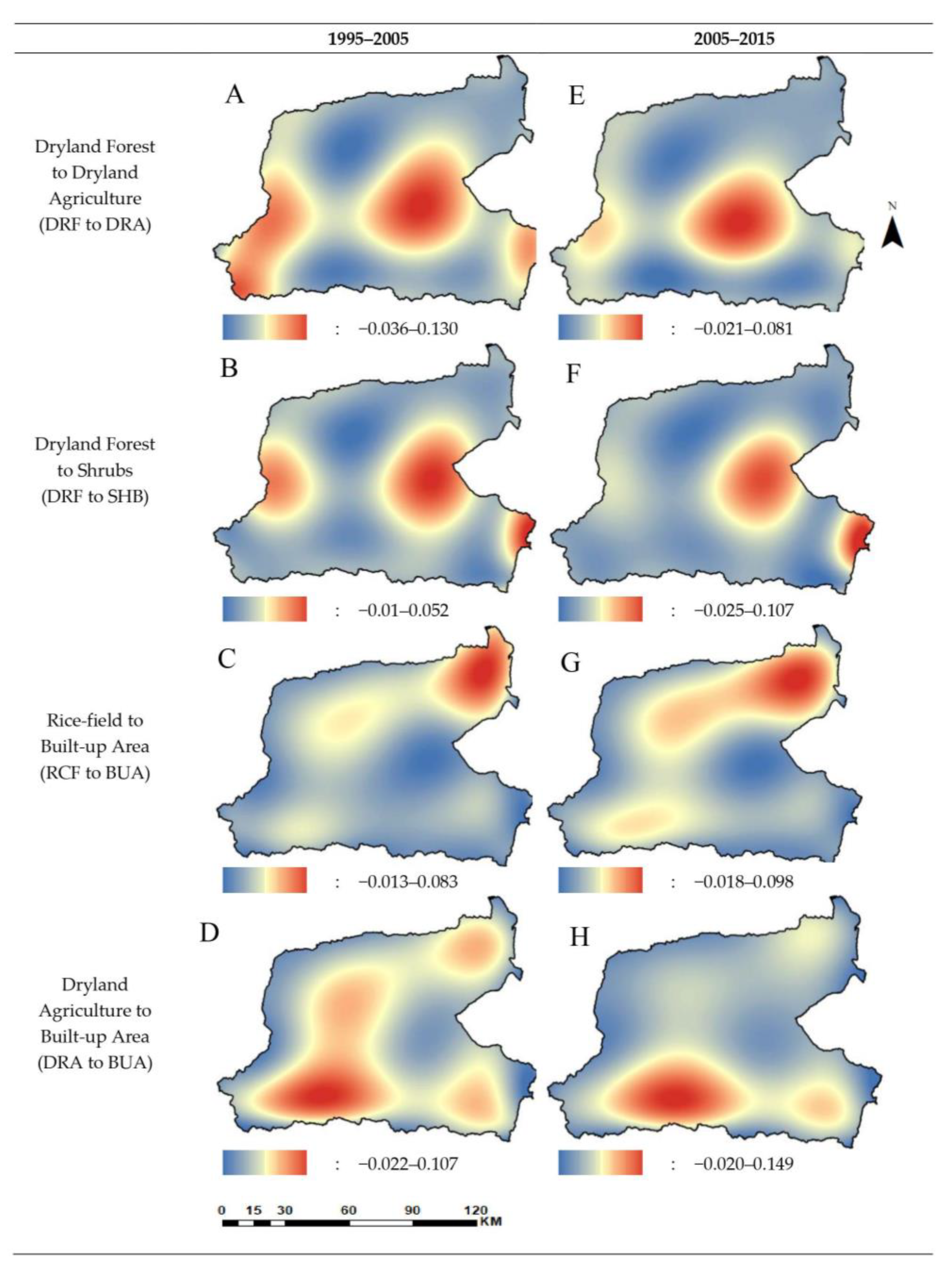
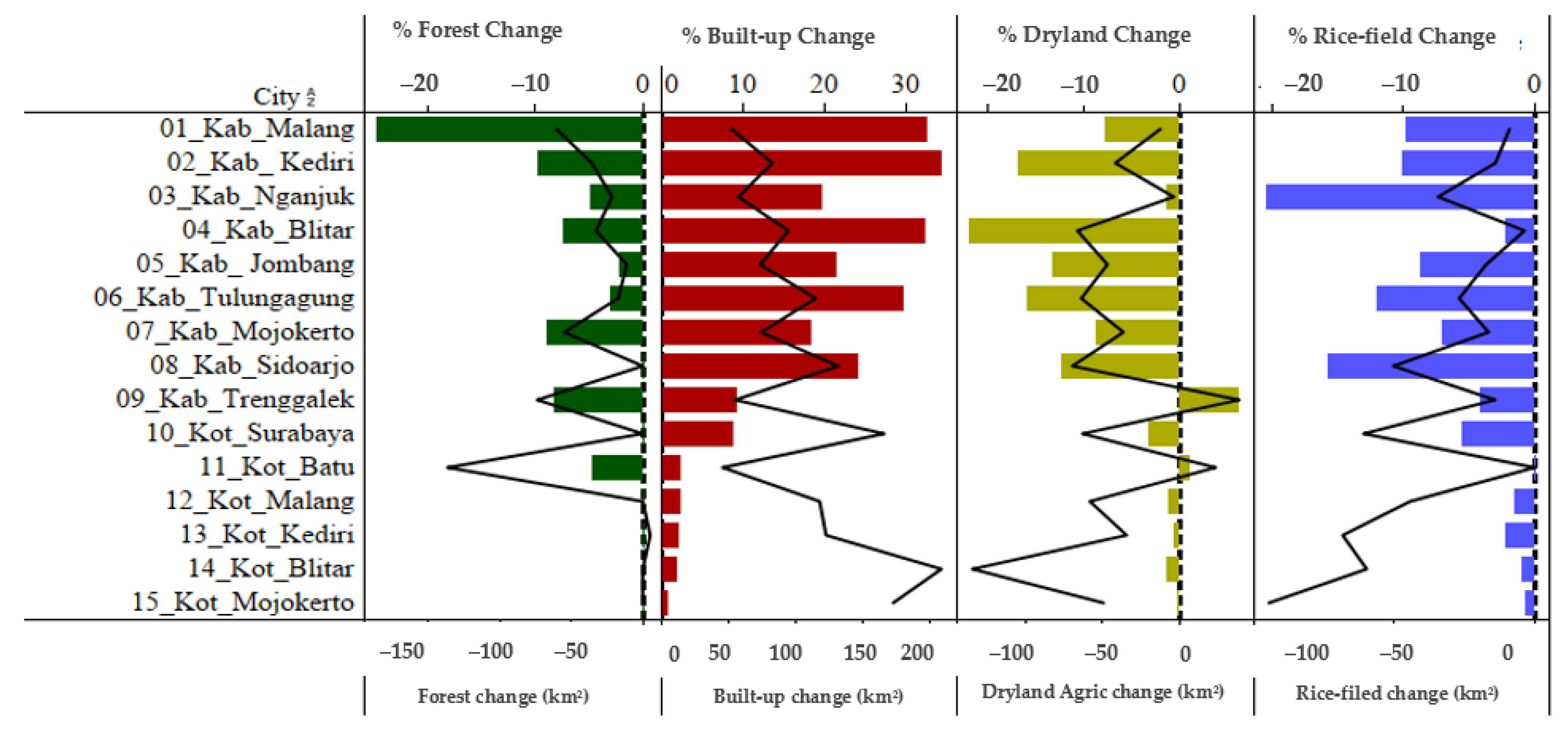
3.2. Land-Use Transition Spatial Patterns (Trend of Changes)
3.3. Potential Land-Use Drivers from Land Change Modeler
3.4. Perceived Land-Use Change Drivers
3.5. Agreement between LCM-Based Drivers and Questionnaire-Based Drivers
4. Discussion
4.1. Land-Use Changes in the Brantas River Basin
4.2. Land-Use Transitions and Land-Use Patterns
4.3. Implication for Land-Use Change Modeling and Driver Assessment
4.4. Limitations of the Study
5. Conclusions
Author Contributions
Funding
Data Availability Statement
Acknowledgments
Conflicts of Interest
Appendix A

| Sector | Driver Group | Variables | Reference |
|---|---|---|---|
| Agriculture | Biophysical | Drought or flood or diseases | [118] |
| Infertile/unproductive/erosion | [26,119] | ||
| Natural water availability | [26,120] | ||
| Culture | Social empowerment | [15,121] | |
| Land contract/customary land tenure system | [17,32] | ||
| Demography/ population | Manpower availability | [26] | |
| Growing family members | [26] | ||
| Economy | Funding for farming practices | [15,32] | |
| Needs of urgent huge cash | [122] | ||
| Seeing peer/neighbor success (business) | [121] | ||
| High-cost land preparation and tillage | [15] | ||
| Market price fluctuation/low price | [23] | ||
| Access to buyers | [123] | ||
| Loans and subsidies availability | [15] | ||
| Infrastructure | Irrigation network | [7,124] | |
| Policy/ institutional | Network availability for direct selling—ease of selling | [32] | |
| Market guarantee | [125] | ||
| Awareness to planning policy and land administration responsibility | [15] | ||
| Technology | Agricultural technologies access and availability (i.e., seeds, fertilizers) | [17,126] | |
| Applying machineries | [126] | ||
| Housing | Biophysical | Natural beauty (site quality) | [124,127] |
| Natural water availability | [120,127] | ||
| Demography/ population | Basic need/growing family members | [128] | |
| Economy | Investment (business) | [129,130] | |
| Land/Housing Price | [15,128] | ||
| Infrastructure | Road access and location | [26] | |
| Distance to markets or school or workplace | [26] | ||
| Facilities (communication and electricity) | [15,127] | ||
| Policy/ institutional | Safety/crime | [127] | |
| Understanding to spatial plan zonation | [131] | ||
| Understanding to tax and land regulation | [130] |
Appendix B
| Land-Use | Code | 1995 | 2005 | 2015 | ||||||
|---|---|---|---|---|---|---|---|---|---|---|
| PA (%) | UA (%) | Average | PA (%) | UA (%) | Average | PA (%) | UA (%) | Average | ||
| Water | WTR | 92.31 | 85.71 | 89.01 | na* | na | na | 96.36 | 98.15 | 97.26 |
| Dryland forest | DRF | 100.00 | 100.00 | 100.00 | 100.00 | 100.00 | 100.00 | 100.00 | 86.11 | 93.06 |
| Mangrove forest | MGF | 86.59 | 94.04 | 90.32 | na | na | na | 89.36 | 95.89 | 92.63 |
| Dryland agriculture | DRA | 93.26 | 93.99 | 93.63 | 90.68 | 88.43 | 89.56 | 91.89 | 86.11 | 89.00 |
| Built-up areas | BUA | 86.84 | 91.67 | 89.26 | 89.13 | 93.18 | 91.16 | 81.89 | 87.83 | 84.86 |
| Sand/soil (bareland) | PST | 89.47 | 85.00 | 87.24 | 100.00 | 100.00 | 100.00 | 89.29 | 67.57 | 78.43 |
| Shrubs and bushes | SMB | 82.61 | 82.61 | 82.61 | 100.00 | 100.00 | 100.00 | 82.61 | 73.08 | 77.85 |
| Rice | SWH | 93.33 | 82.35 | 87.84 | 83.10 | 84.29 | 83.70 | 77.34 | 83.66 | 80.50 |
| Ponds | TBK | 96.15 | 96.15 | 96.15 | 100.00 | 100.00 | 100.00 | 92.68 | 97.44 | 95.06 |
| Overall accuracy (%) | 91.13 | 88.84 | 87.33 | |||||||
| Kappa accuracy (%) | 87.06 | 83.01 | 83.1 | |||||||
| Sample size | 823 | 251 | 1776 | |||||||
Appendix C
| LULC 1995 (km2) | LULC 2005 (km2) | ||||||||
|---|---|---|---|---|---|---|---|---|---|
| WTR | DRF | MGF | DRA | BUA | BRL | SHB | RCF | PND | |
| Water (WTR) | 49.38 | 0.02 | 0.49 | 11.76 | 5.46 | 0.65 | 0.00 | 12.35 | 3.79 |
| Dryland forest (DRF) | 0.26 | 781.95 | 0.00 | 413.20 | 0.78 | 0.44 | 103.38 | 1.85 | 0.00 |
| Mangrove forest (MGF) | 0.46 | 0.00 | 0.98 | 0.66 | 0.18 | 1.68 | 0.00 | 0.15 | 3.61 |
| Dryland agriculture (DRA) | 7.24 | 57.69 | 0.22 | 4889.48 | 448.67 | 5.51 | 14.48 | 459.63 | 3.44 |
| Built-up areas (BUA) | 0.00 | 0.00 | 0.00 | 0.00 | 841.64 | 0.00 | 0.00 | 0.00 | 0.00 |
| Bareland (BRL) | 1.02 | 1.05 | 0.42 | 10.17 | 5.18 | 9.42 | 5.16 | 4.35 | 6.44 |
| Shrubs and bushes (SHB) | 0.05 | 35.84 | 0.00 | 58.58 | 0.36 | 0.18 | 119.66 | 0.37 | 0.00 |
| Rice-field (RCF) | 3.48 | 0.27 | 0.00 | 380.85 | 207.77 | 2.55 | 0.17 | 2666.18 | 2.55 |
| Ponds (PND) | 2.12 | 0.02 | 0.94 | 1.69 | 3.13 | 7.40 | 0.00 | 1.69 | 171.82 |
| LULC 2005 (km2) | LULC 2015 (km2) | ||||||||
| WTR | DRF | MGF | DRA | BUA | BRL | SHB | RCF | PND | |
| Water (WTR) | 49.75 | 0.06 | 1.44 | 3.92 | 2.08 | 0.45 | 0.04 | 5.25 | 1.01 |
| Dryland forest (DRF) | 0.13 | 546.47 | 0.00 | 171.05 | 1.19 | 3.29 | 153.85 | 0.86 | 0.00 |
| Mangrove forest (MGF) | 0.17 | 0.00 | 2.11 | 0.00 | 0.00 | 0.42 | 0.00 | 0.02 | 0.32 |
| Dryland agriculture (DRA) | 12.57 | 151.53 | 1.18 | 4579.72 | 535.10 | 6.44 | 65.68 | 413.23 | 0.95 |
| Built-up areas (BUA) | 0.00 | 0.00 | 0.00 | 0.00 | 1513.16 | 0.00 | 0.00 | 0.00 | 0.00 |
| Bareland (BRL) | 0.27 | 0.22 | 2.41 | 3.03 | 4.10 | 8.43 | 0.63 | 2.77 | 5.97 |
| Shrubs and bushes (SHB) | 0.02 | 31.24 | 0.00 | 33.12 | 0.06 | 8.71 | 169.50 | 0.20 | 0.00 |
| Rice-field (RCF) | 11.73 | 1.17 | 0.15 | 482.29 | 294.31 | 5.60 | 0.27 | 2346.32 | 4.73 |
| Ponds (PND) | 1.13 | 0.00 | 5.55 | 0.37 | 3.70 | 18.70 | 0.00 | 6.17 | 156.05 |
References
- Faleiro, F.V.; Machado, R.B.; Loyola, R.D. Defining spatial conservation priorities in the face of land-use and climate change. Biol. Conserv. 2013, 158, 248–257. [Google Scholar] [CrossRef]
- Van Vliet, J.; de Groot, H.L.F.; Rietveld, P.; Verburg, P.H. Manifestations and underlying drivers of agricultural land use change in Europe. Landsc. Urban Plan. 2015, 133, 24–36. [Google Scholar] [CrossRef] [Green Version]
- Wagner, P.D.; Bhallamudi, S.M.; Narasimhan, B.; Kantakumar, L.N.; Sudheer, K.P.; Kumar, S.; Schneider, K.; Fiener, P. Dynamic integration of land use changes in a hydrologic assessment of a rapidly developing Indian catchment. Sci. Total Environ. 2016, 539, 153–164. [Google Scholar] [CrossRef] [PubMed]
- Xu, R.; Tian, F.; Yang, L.; Hu, H.; Lu, H.; Hou, A. Ground validation of GPM IMERG and TRMM 3B42V7 rainfall products over southern Tibetan Plateau based on a high-density rain gauge network. J. Geophys. Res. Atmos. 2017, 122, 910–924. [Google Scholar] [CrossRef]
- Rimal, B.; Baral, H.; Stork, N.E.; Paudyal, K.; Rijal, S. Growing city and rapid land use transition: Assessing multiple hazards and risks in the Pokhara Valley, Nepal. Land 2015, 4, 957–978. [Google Scholar] [CrossRef] [Green Version]
- Firman, T. Major issues in Indonesia’s urban land development. Land Use Policy 2004, 21, 347–355. [Google Scholar] [CrossRef]
- Partoyo; Shrestha, R.P. Monitoring farmland loss and projecting the future land use of an urbanized watershed in Yogyakarta, Indonesia. J. Land Use Sci. 2013, 8, 59–84. [Google Scholar]
- Margono, B.A.; Usman, A.B.; Sugardiman, R.A. Indonesia’s Forest Resource Monitoring. Indones. J. Geogr. 2016, 48, 7. [Google Scholar] [CrossRef]
- Bürgi, M.; Hersperger, A.M.; Schneeberger, N. Driving forces of landscape change-current and new directions. Landsc. Ecol. 2005, 19, 857–868. [Google Scholar] [CrossRef]
- Van Vliet, N.; Mertz, O.; Heinimann, A.; Langanke, T.; Pascual, U.; Schmook, B.; Adams, C.; Schmidt-Vogt, D.; Messerli, P.; Leisz, S. Trends, drivers and impacts of changes in swidden cultivation in tropical forest-agriculture frontiers: A global assessment. Glob. Environ. Chang. 2012, 22, 418–429. [Google Scholar] [CrossRef]
- Biazin, B.; Sterk, G. Drought vulnerability drives land-use and land cover changes in the Rift Valley dry lands of Ethiopia. Agric. Ecosyst. Environ. 2013, 164, 100–113. [Google Scholar] [CrossRef]
- Chebli, Y.; Chentouf, M.; Ozer, P.; Hornick, J.-L.; Cabaraux, J.-F. Forest and silvopastoral cover changes and its drivers in northern Morocco. Appl. Geogr. 2018, 101, 23–35. [Google Scholar] [CrossRef]
- Freitas, S.R.; Hawbaker, T.J.; Metzger, J.P. Effects of roads, topography, and land use on forest cover dynamics in the Brazilian Atlantic Forest. For. Ecol. Manag. 2010, 259, 410–417. [Google Scholar] [CrossRef]
- Kleemann, J.; Baysal, G.; Bulley, H.N.N.; Fürst, C. Assessing driving forces of land use and land cover change by a mixed-method approach in north-eastern Ghana, West Africa. J. Environ. Manag. 2017, 196, 411–442. [Google Scholar] [CrossRef]
- Lambin, E.F.; Geist, H.J. Regional differences in tropical deforestation. Environ. Sci. Policy Sustain. Dev. 2003, 45, 22–36. [Google Scholar] [CrossRef]
- Delphin, S.; Escobedo, F.J.; Abd-Elrahman, A.; Cropper, W.P. Urbanization as a land use change driver of forest ecosystem services. Land Use Policy 2016, 54, 188–199. [Google Scholar] [CrossRef] [Green Version]
- Verbist, B.; Putra, A.E.D.; Budidarsono, S. Factors driving land use change: Effects on watershed functions in a coffee agroforestry system in Lampung, Sumatra. Agric. Syst. 2005, 85, 254–270. [Google Scholar] [CrossRef]
- Bray, D.B.; Ellis, E.A.; Armijo-Canto, N.; Beck, C.T. The institutional drivers of sustainable landscapes: A case study of the ‘Mayan Zone’in Quintana Roo, Mexico. Land Use Policy 2004, 21, 333–346. [Google Scholar] [CrossRef]
- Kindu, M.; Schneider, T.; Teketay, D.; Knoke, T. Drivers of land use/land cover changes in Munessa-Shashemene landscape of the south-central highlands of Ethiopia. Environ. Monit. Assess. 2015, 187, 452. [Google Scholar] [CrossRef]
- Li, M.; Wu, J.; Deng, X. Identifying drivers of land use change in China: A spatial multinomial logit model analysis. Land Econ. 2013, 89, 632–654. [Google Scholar] [CrossRef]
- Rudel, T.K.; Defries, R.; Asner, G.P.; Laurance, W.F. Changing drivers of deforestation and new opportunities for conservation. Conserv. Biol. 2009, 23, 1396–1405. [Google Scholar] [CrossRef] [PubMed]
- Serneels, S.; Lambin, E.F. Proximate causes of land-use change in Narok District, Kenya: A spatial statistical model. Agric. Ecosyst. Environ. 2001, 85, 65–81. [Google Scholar] [CrossRef] [Green Version]
- Ostrom, E. A general framework for analyzing sustainability of social-ecological systems. Science 2009, 325, 419–422. [Google Scholar] [CrossRef] [PubMed]
- Gibson, L.; Münch, Z.; Palmer, A.; Mantel, S. Future land cover change scenarios in South African grasslands–implications of altered biophysical drivers on land management. Heliyon 2018, 4, e00693. [Google Scholar] [CrossRef] [Green Version]
- Verburg, P.H.; Soepboer, W.; Veldkamp, A.; Limpiada, R.; Espaldon, V.; Mastura, S.S.A. Modeling the spatial dynamics of regional land use: The CLUE-S model. Environ. Manag. 2002, 30, 391–405. [Google Scholar] [CrossRef]
- Verburg, P.H.; Bouma, J. Land use change under conditions of high population pressure: The case of Java. Glob. Environ. Chang. 1999, 9, 303–312. [Google Scholar] [CrossRef]
- Coral, C.; Bokelmann, W. The role of analytical frameworks for systemic research design, explained in the analysis of drivers and dynamics of historic land-use changes. Systems 2017, 5, 20. [Google Scholar] [CrossRef] [Green Version]
- Sorice, M.G.; Kreuter, U.P.; Wilcox, B.P.; Fox III, W.E. Changing landowners, changing ecosystem? Land-ownership motivations as drivers of land management practices. J. Environ. Manag. 2014, 133, 144–152. [Google Scholar] [CrossRef]
- Belay, T.; Mengistu, D.A. Land use and land cover dynamics and drivers in the Muga watershed, Upper Blue Nile basin, Ethiopia. Remote Sens. Appl. Soc. Environ. 2019, 15, 100249. [Google Scholar] [CrossRef]
- Fox, J.; Vogler, J.B. Land-use and land-cover change in montane mainland southeast Asia. Environ. Manag. 2005, 36, 394–403. [Google Scholar] [CrossRef]
- Nor, A.N.M.; Corstanje, R.; Harris, J.A.; Brewer, T. Impact of rapid urban expansion on green space structure. Ecol. Indic. 2017, 81, 274–284. [Google Scholar] [CrossRef]
- Suryanata, K. Fruit trees under contract: Tenure and land use change in upland Java, Indonesia. World Dev. 1994, 22, 1567–1578. [Google Scholar] [CrossRef]
- Erickson, D.L. Rural land use and land cover change: Implications for local planning in the River Raisin watershed. Land Use Policy 1995, 12, 223–236. [Google Scholar] [CrossRef]
- Mendoza, M.E.; Granados, E.L.; Geneletti, D.; Pérez-Salicrup, D.R.; Salinas, V. Analysing land cover and land use change processes at watershed level: A multitemporal study in the Lake Cuitzeo Watershed, Mexico (1975–2003). Appl. Geogr. 2011, 31, 237–250. [Google Scholar] [CrossRef]
- Tomer, M.D.; Schilling, K.E. A simple approach to distinguish land-use and climate-change effects on watershed hydrology. J. Hydrol. 2009, 376, 24–33. [Google Scholar] [CrossRef]
- Wang, R.; Kalin, L.; Kuang, W.; Tian, H. Individual and combined effects of land use/cover and climate change on Wolf Bay watershed streamflow in southern Alabama. Hydrol. Process. 2014, 28, 5530–5546. [Google Scholar] [CrossRef]
- Tu, J.; Xia, Z.-G.; Clarke, K.C.; Frei, A. Impact of urban sprawl on water quality in eastern Massachusetts, USA. Environ. Manag. 2007, 40, 183–200. [Google Scholar] [CrossRef]
- Wilson, C.O.; Weng, Q. Simulating the impacts of future land use and climate changes on surface water quality in the Des Plaines River watershed, Chicago Metropolitan Statistical Area, Illinois. Sci. Total Environ. 2011, 409, 4387–4405. [Google Scholar] [CrossRef]
- Surya, B.; Salim, A.; Hernita, H.; Suriani, S.; Menne, F.; Rasyidi, E.S. Land use change, urban agglomeration, and urban sprawl: A sustainable development perspective of Makassar City, Indonesia. Land 2021, 10, 556. [Google Scholar] [CrossRef]
- Margono, B.A.; Potapov, P.V.; Turubanova, S.; Stolle, F.; Hansen, M.C. Primary forest cover loss in Indonesia over 2000–2012. Nat. Clim. Chang. 2014, 4, 730–735. [Google Scholar] [CrossRef]
- Widianto, D.; Suprayogo, S.L.; Dewi, S. Implementasi Kaji Cepat Hidrologi (RHA) di Hulu DAS Brantas, Jawa Timur; World Agroforestry Centre ICRAF Southeast Asia Regional Office: Bogor, Indonesia, 2010. [Google Scholar]
- Nesheim, I.; Reidsma, P.; Bezlepkina, I.; Verburg, R.; Abdeladhim, M.A.; Bursztyn, M.; Chen, L.; Cisse, Y.; Feng, S.; Gicheru, P. Causal chains, policy trade offs and sustainability: Analysing land (mis) use in seven countries in the South. Land Use Policy 2014, 37, 60–70. [Google Scholar] [CrossRef]
- Hadiz, V. Reorganizing political power in Indonesia: A reconsideration of so-called’democratic transitions’. Pac. Rev. 2003, 16, 591–611. [Google Scholar] [CrossRef]
- Freedman, A.L. Economic crises and political change: Indonesia, South Korea, and Malaysia. Asian Aff. Am. Rev. 2005, 31, 232–249. [Google Scholar] [CrossRef]
- Aprianto, T.C. Perjuangan Landreform Masyarakat Perkebunan: Partisipasi Politik, Klaim, dan Konflik Agraria di Jember; STPN Press: Yogyakarta, Indonesia, 2016; ISBN 6027894296. [Google Scholar]
- Naylor, R.L.; Higgins, M.M.; Edwards, R.B.; Falcon, W.P. Decentralization and the environment: Assessing smallholder oil palm development in Indonesia. Ambio 2019, 48, 1195–1208. [Google Scholar] [CrossRef]
- Alaerts, G.J. Adaptive policy implementation: Process and impact of Indonesia’s national irrigation reform 1999–2018. World Dev. 2020, 129, 104880. [Google Scholar] [CrossRef]
- Timur, P.J. Rencana Tata Ruang Wilayah Propinsi Jawa Timur 2011–2031; Pemerintah Propinsi Jawa: Surabaya, Indonesia, 2011. Available online: https://bappeda.jatimprov.go.id/dokumen-perencanaan/ (accessed on 18 February 2023).
- Duncan, C.R. Mixed outcomes: The impact of regional autonomy and decentralization on indigenous ethnic minorities in Indonesia. Dev. Chang. 2007, 38, 711–733. [Google Scholar] [CrossRef]
- Firman, T. The continuity and change in mega-urbanization in Indonesia: A survey of Jakarta–Bandung Region (JBR) development. Habitat Int. 2009, 33, 327–339. [Google Scholar] [CrossRef]
- Tsujino, R.; Yumoto, T.; Kitamura, S.; Djamaluddin, I.; Darnaedi, D. History of forest loss and degradation in Indonesia. Land Use Policy 2016, 57, 335–347. [Google Scholar] [CrossRef]
- Winkler, K.; Fuchs, R.; Rounsevell, M.; Herold, M. Global land use changes are four times greater than previously estimated. Nat. Commun. 2021, 12, 2501. [Google Scholar] [CrossRef]
- Sang, X.; Guo, Q.; Wu, X.; Fu, Y.; Xie, T.; He, C.; Zang, J. Intensity and stationarity analysis of land use change based on CART algorithm. Sci. Rep. 2019, 9, 12279. [Google Scholar] [CrossRef] [Green Version]
- Chen, W.; Chi, G.; Li, J. The spatial association of ecosystem services with land use and land cover change at the county level in China, 1995–2015. Sci. Total Environ. 2019, 669, 459–470. [Google Scholar] [CrossRef] [PubMed]
- Austin, K.G.; Mosnier, A.; Pirker, J.; McCallum, I.; Fritz, S.; Kasibhatla, P.S. Shifting patterns of oil palm driven deforestation in Indonesia and implications for zero-deforestation commitments. Land Use Policy 2017, 69, 41–48. [Google Scholar] [CrossRef] [Green Version]
- Astuti, I.S.; Sahoo, K.; Milewski, A.; Mishra, D.R. Impact of land use land cover (LULC) change on surface runoff in an increasingly urbanized tropical watershed. Water Resour. Manag. 2019, 33, 4087–4103. [Google Scholar] [CrossRef]
- Neupane, M.; Dhakal, S. Climatic Variability and Land Use Change in Kamala Watershed, Sindhuli District, Nepal. Climate 2017, 5, 11. [Google Scholar] [CrossRef] [Green Version]
- Zhou, Y.; Li, X.; Liu, Y. Land use change and driving factors in rural China during the period 1995–2015. Land Use Policy 2020, 99, 105048. [Google Scholar] [CrossRef]
- Pawitan, H.; Haryani, G.S. Water resources, sustainability and societal livelihoods in Indonesia. Ecohydrol. Hydrobiol. 2011, 11, 231–243. [Google Scholar] [CrossRef]
- Pambudi, A.S.; Moersidik, S.S.; Karuniasa, M. Analysis of recent erosion hazard levels and conservation policy recommendations for Lesti Subwatershed, Upper Brantas Watershed. J. Perenc. Pembang. Indones. J. Dev. Plan. 2021, 5, 71–93. [Google Scholar] [CrossRef]
- Bhat, A. The politics of model maintenance: The Murray Darling and Brantas River Basins compared. Water Altern. 2008, 1, 201. [Google Scholar]
- Rijsdijk, A. Evaluating sediment sources and delivery in. Sediment Budg. 2005, 292, 16. [Google Scholar]
- Trianni, G.; Lisini, G.; Angiuli, E.; Moreno, E.A.; Dondi, P.; Gaggia, A.; Gamba, P. Scaling up to national/regional urban extent mapping using Landsat data. IEEE J. Sel. Top. Appl. Earth Obs. Remote Sens. 2015, 8, 3710–3719. [Google Scholar] [CrossRef]
- Goward, S.; Arvidson, T.; Williams, D.; Faundeen, J.; Irons, J.; Franks, S. Historical record of Landsat global coverage. Photogramm. Eng. Remote Sens. 2006, 72, 1155–1169. [Google Scholar] [CrossRef]
- Asgarian, A.; Soffianian, A.; Pourmanafi, S. Crop type mapping in a highly fragmented and heterogeneous agricultural landscape: A case of central Iran using multi-temporal Landsat 8 imagery. Comput. Electron. Agric. 2016, 127, 531–540. [Google Scholar] [CrossRef]
- Rocchini, D. Effects of spatial and spectral resolution in estimating ecosystem α-diversity by satellite imagery. Remote Sens. Environ. 2007, 111, 423–434. [Google Scholar] [CrossRef]
- Sidik, F.; Neil, D.; Lovelock, C.E. Effect of high sedimentation rates on surface sediment dynamics and mangrove growth in the Porong River, Indonesia. Mar. Pollut. Bull. 2016, 107, 355–363. [Google Scholar] [CrossRef]
- Vermote, E.; Justice, C.; Claverie, M.; Franch, B. Preliminary analysis of the performance of the Landsat 8/OLI land surface reflectance product. Remote Sens. Environ. 2016, 185, 46–56. [Google Scholar] [CrossRef]
- Leinenkugel, P.; Kuenzer, C.; Oppelt, N.; Dech, S. Characterisation of land surface phenology and land cover based on moderate resolution satellite data in cloud prone areas—A novel product for the Mekong Basin. Remote Sens. Environ. 2013, 136, 180–198. [Google Scholar] [CrossRef]
- Hadjimitsis, D.G.; Papadavid, G.; Agapiou, A.; Themistocleous, K.; Hadjimitsis, M.G.; Retalis, A.; Michaelides, S.; Chrysoulakis, N.; Toulios, L.; Clayton, C.R.I. Atmospheric correction for satellite remotely sensed data intended for agricultural applications: Impact on vegetation indices. Nat. Hazards Earth Syst. Sci. 2010, 10, 89–95. [Google Scholar] [CrossRef] [Green Version]
- Hegewisch, K. Climate Engine. Desert Research Institute and University of Idaho, 2017. Available online: https://www.lib.uidaho.edu/media/workshops/GISDay2017_Hegewisch.pdf (accessed on 18 February 2023).
- Deshpande, S.D.; Er, M.H.; Venkateswarlu, R.; Chan, P. Max-mean and max-median filters for detection of small targets. In Signal and Data Processing of Small Targets 1999; International Society for Optics and Photonics: Bellingham, DC, USA, 1999; Volume 3809, pp. 74–83. [Google Scholar]
- eCognition Developer, T. 9.0 User Guide; Trimble Germany GmbH: Munich, Germany, 2014.
- Blaschke, T.; Hay, G.J.; Kelly, M.; Lang, S.; Hofmann, P.; Addink, E.; Queiroz Feitosa, R.; van der Meer, F.; van der Werff, H.; van Coillie, F.; et al. Geographic Object-Based Image Analysis—Towards a new paradigm. ISPRS J. Photogramm. Remote Sens. 2014, 87, 180–191. [Google Scholar] [CrossRef] [Green Version]
- Hamedianfar, A.; Shafri, H.Z.M. Detailed intra-urban mapping through transferable OBIA rule sets using WorldView-2 very-high-resolution satellite images. Int. J. Remote Sens. 2015, 36, 3380–3396. [Google Scholar] [CrossRef]
- Li, X.; Myint, S.W.; Zhang, Y.; Galletti, C.; Zhang, X.; Turner, B.L., II. Object-based land-cover classification for metropolitan Phoenix, Arizona, using aerial photography. Int. J. Appl. Earth Obs. Geoinf. 2014, 33, 321–330. [Google Scholar] [CrossRef]
- Liu, D.; Xia, F. Assessing object-based classification: Advantages and limitations. Remote Sens. Lett. 2010, 1, 187–194. [Google Scholar] [CrossRef]
- Hussain, M.; Chen, D.; Cheng, A.; Wei, H.; Stanley, D. Change detection from remotely sensed images: From pixel-based to object-based approaches. ISPRS J. Photogramm. Remote Sens. 2013, 80, 91–106. [Google Scholar] [CrossRef]
- Guirado, E.; Blanco-Sacristán, J.; Rodríguez-Caballero, E.; Tabik, S.; Alcaraz-Segura, D.; Martínez-Valderrama, J.; Cabello, J. Mask R-CNN and OBIA fusion improves the segmentation of scattered vegetation in very high-resolution optical sensors. Sensors 2021, 21, 320. [Google Scholar] [CrossRef] [PubMed]
- Roelfsema, C.M.; Lyons, M.; Kovacs, E.M.; Maxwell, P.; Saunders, M.I. Multi-temporal mapping of seagrass cover, species and biomass: A semi-automated object based image analysis approach. Remote Sens. Environ. 2014, 150, 172–187. [Google Scholar] [CrossRef]
- Torres-Sánchez, J.; López-Granados, F.; Pena, J.M. An automatic object-based method for optimal thresholding in UAV images: Application for vegetation detection in herbaceous crops. Comput. Electron. Agric. 2015, 114, 43–52. [Google Scholar] [CrossRef]
- Blaschke, T. Object based image analysis for remote sensing. ISPRS J. Photogramm. Remote Sens. 2010, 65, 2–16. [Google Scholar] [CrossRef] [Green Version]
- Myint, S.W.; Gober, P.; Brazel, A.; Grossman-Clarke, S.; Weng, Q. Per-pixel vs. object-based classification of urban land cover extraction using high spatial resolution imagery. Remote Sens. Environ. 2011, 115, 1145–1161. [Google Scholar] [CrossRef]
- Chen, X.-L.; Zhao, H.-M.; Li, P.-X.; Yin, Z.-Y. Remote sensing image-based analysis of the relationship between urban heat island and land use/cover changes. Remote Sens. Environ. 2006, 104, 133–146. [Google Scholar] [CrossRef]
- Usman, M.; Liedl, R.; Shahid, M.A.; Abbas, A. Land use/land cover classification and its change detection using multi-temporal MODIS NDVI data. J. Geogr. Sci. 2015, 25, 1479–1506. [Google Scholar] [CrossRef]
- Palinkas, L.A.; Horwitz, S.M.; Green, C.A.; Wisdom, J.P.; Duan, N.; Hoagwood, K. Purposeful sampling for qualitative data collection and analysis in mixed method implementation research. Adm. Policy Ment. Health Ment. Health Serv. Res. 2015, 42, 533–544. [Google Scholar] [CrossRef] [Green Version]
- Story, M.; Congalton, R.G. Accuracy assessment: A user’s perspective. Photogramm. Eng. Remote Sens. 1986, 52, 397–399. [Google Scholar]
- Abd El-Kawy, O.R.; Rød, J.K.; Ismail, H.A.; Suliman, A.S. Land use and land cover change detection in the western Nile delta of Egypt using remote sensing data. Appl. Geogr. 2011, 31, 483–494. [Google Scholar] [CrossRef]
- Jensen, J.R.; Toll, D.L. Detecting residential land-use development at the urban fringe. Photogramm. Eng. Remote Sens. 1982, 48, 19820045797. [Google Scholar]
- Tewkesbury, A.P.; Comber, A.J.; Tate, N.J.; Lamb, A.; Fisher, P.F. A critical synthesis of remotely sensed optical image change detection techniques. Remote Sens. Environ. 2015, 160, 1–14. [Google Scholar] [CrossRef] [Green Version]
- Jianya, G.; Haigang, S.; Guorui, M.; Qiming, Z. A review of multi-temporal remote sensing data change detection algorithms. Int. Arch. Photogramm. Remote Sens. Spat. Inf. Sci. 2008, 37, 757–762. [Google Scholar]
- Xystrakis, F.; Psarras, T.; Koutsias, N. A process-based land use/land cover change assessment on a mountainous area of Greece during 1945–2009: Signs of socio-economic drivers. Sci. Total Environ. 2017, 587, 360–370. [Google Scholar] [CrossRef]
- Eastman, J.R. TerrSet Geospatial Monitoring and Modeling System–Manual; Clark University: Worcester, MA, USA, 2016. [Google Scholar]
- Chorley, R.J.; Haggett, P. Trend-surface mapping in geographical research. Trans. Inst. Br. Geogr. 1965, 47–67. [Google Scholar] [CrossRef]
- Václavík, T.; Rogan, J. Identifying trends in land use/land cover changes in the context of post-socialist transformation in central Europe: A case study of the greater Olomouc region, Czech Republic. GIScience Remote Sens. 2009, 46, 54–76. [Google Scholar] [CrossRef] [Green Version]
- Saifullah, K.; Barus, B.; Rustiadi, E. Spatial modelling of land use/cover change (LUCC) in South Tangerang City, Banten. In IOP Conference Series: Earth and Environmental Science; IOP Publishing: Bristol, UK, 2017; Volume 54, p. 12018. [Google Scholar]
- Islam, K.; Rahman, M.F.; Jashimuddin, M. Modeling land use change using cellular automata and artificial neural network: The case of Chunati Wildlife Sanctuary, Bangladesh. Ecol. Indic. 2018, 88, 439–453. [Google Scholar] [CrossRef]
- Gupta, R.; Sharma, L.K. Efficacy of Spatial Land Change Modeler as a forecasting indicator for anthropogenic change dynamics over five decades: A case study of Shoolpaneshwar Wildlife Sanctuary, Gujarat, India. Ecol. Indic. 2020, 112, 106171. [Google Scholar] [CrossRef]
- Vinayak, B.; Lee, H.S.; Gedem, S. Prediction of land use and land cover changes in Mumbai City, India, using remote sensing data and a multilayer perceptron neural network-based Markov chain model. Sustainability 2021, 13, 471. [Google Scholar] [CrossRef]
- Gray, D.A.; Chomitz, K.M.; Mundial, B. Roads, Lands, Markets, and Deforestation: A Spatial Model of Land Use in Belize; Banco Mundial: Washington, DC, USA, 1995. [Google Scholar]
- Handayani, W. Rural-urban transition in Central Java: Population and economic structural changes based on cluster analysis. Land 2013, 2, 419–436. [Google Scholar] [CrossRef] [Green Version]
- Overmars, K.P.; Verburg, P.H. Analysis of land use drivers at the watershed and household level: Linking two paradigms at the Philippine forest fringe. Int. J. Geogr. Inf. Sci. 2005, 19, 125–152. [Google Scholar] [CrossRef]
- Eastman, J.R.; Toledano, J. A short presentation of the Land Change Modeler (LCM). In Geomatic Approaches for Modeling Land Change Scenarios; Springer: Berlin/Heidelberg, Germany, 2018; pp. 499–505. [Google Scholar]
- Kamwi, J.M.; Cho, M.A.; Kaetsch, C.; Manda, S.O.; Graz, F.P.; Chirwa, P.W. Assessing the spatial drivers of land use and land cover change in the protected and communal areas of the Zambezi Region, Namibia. Land 2018, 7, 131. [Google Scholar] [CrossRef] [Green Version]
- Ewane, E.B. Land use land cover change and the resilience of social-ecological systems in a sub-region in South west Cameroon. Environ. Monit. Assess. 2021, 193, 338. [Google Scholar] [CrossRef]
- Deadman, P.; Robinson, D.; Moran, E.; Brondizio, E. Colonist household decisionmaking and land-use change in the Amazon Rainforest: An agent-based simulation. Environ. Plan. B Plan. Des. 2004, 31, 693–709. [Google Scholar] [CrossRef] [Green Version]
- Bank, W. Indonesia: Water Use Rights Study: Stage 2, Final Report Volume 1; 2004. Available online: https://documents.worldbank.org/en/publication/documents-reports/documentdetail/546631468263057128/annexes (accessed on 18 February 2023).
- Brun, C.; Cook, A.R.; Lee, J.S.H.; Wich, S.A.; Koh, L.P.; Carrasco, L.R. Analysis of deforestation and protected area effectiveness in Indonesia: A comparison of Bayesian spatial models. Glob. Environ. Chang. 2015, 31, 285–295. [Google Scholar] [CrossRef]
- Fulazzaky, M.A. Water quality evaluation system to assess the Brantas River water. Water Resour. Manag. 2009, 23, 3019–3033. [Google Scholar] [CrossRef]
- Wu, K.; Zhang, H. Land use dynamics, built-up land expansion patterns, and driving forces analysis of the fast-growing Hangzhou metropolitan area, eastern China (1978–2008). Appl. Geogr. 2012, 34, 137–145. [Google Scholar] [CrossRef]
- Purnomo, M.; Binternagel, N.; Faust, H. Transformation of resource management in Upland East-Java, Indonesia–From directive power to social and institutional interactions. In Proceedings of the Contributed Paper prepared for Presentation at the International Symposium ‘Sustainable Land Use and Rural Development in Mountainous Regions of Southeast Asia’, Hanoi, Vitnam, 21–23 July 2010; pp. 21–23. [Google Scholar]
- Lambin, E.F.; Geist, H.; Rindfuss, R.R. Introduction: Local processes with global impacts. In Land-Use and Land-Cover Change; Springer: Berlin/Heidelberg, Germany, 2006; pp. 1–8. [Google Scholar]
- Nawir, A.A.; Rumboko, L. History and state of deforestation and land degradation. For. Rehabil. Indones. Where After More Than Three Decad 2007, 11–32. [Google Scholar] [CrossRef] [Green Version]
- Goers, L.; Lawson, J.; Garen, E. Economic drivers of tropical deforestation for agriculture. Manag. For. Carbon A Chang. Clim. 2012, 305–320. [Google Scholar] [CrossRef]
- Gaveau, D.L.A.; Wandono, H.; Setiabudi, F. Three decades of deforestation in southwest Sumatra: Have protected areas halted forest loss and logging, and promoted re-growth? Biol. Conserv. 2007, 134, 495–504. [Google Scholar] [CrossRef]
- Ansari, A.; Golabi, M.H. Prediction of spatial land use changes based on LCM in a GIS environment for Desert Wetlands–A case study: Meighan Wetland, Iran. Int. Soil Water Conserv. Res. 2019, 7, 64–70. [Google Scholar] [CrossRef]
- Calijuri, M.L.; de Castro, J.S.; Costa, L.S.; Assemany, P.P.; Alves, J.E.M. Impact of land use/land cover changes on water quality and hydrological behavior of an agricultural subwatershed. Environ. Earth Sci. 2015, 74, 5373–5382. [Google Scholar] [CrossRef]
- Brown, D.G.; Walker, R.; Manson, S.; Seto, K. Modeling land use and land cover change. In Land Change Science; Springer: Berlin/Heidelberg, Germany, 2012; pp. 395–409. [Google Scholar]
- Jingan, S.; Jiupai, N.; Chaofu, W.; Deti, X. Land use change and its corresponding ecological responses: A review. J. Geogr. Sci. 2005, 15, 305–328. [Google Scholar] [CrossRef]
- Molden, D.; Oweis, T.Y.; Pasquale, S.; Kijne, J.W.; Hanjra, M.A.; Bindraban, P.S.; Bouman, B.A.M.; Mahoo, H.F.; Silva, P.; Upadhyaya, A. Pathways for increasing agricultural water productivity. In Water For Food Water For Life, A Comprehensive Assessment of Water Management; Earthscan: Oxford, UK, 2007. [Google Scholar]
- Martini, E.; Roshetko, J.M.; Paramita, E. Can farmer-to-farmer communication boost the dissemination of agroforestry innovations? A case study from Sulawesi, Indonesia. Agrofor. Syst. 2017, 91, 811–824. [Google Scholar] [CrossRef]
- Rondhi, M.; Pratiwi, P.A.; Handini, V.T.; Sunartomo, A.F.; Budiman, S.A. Agricultural land conversion, land economic value, and sustainable agriculture: A case study in East Java, Indonesia. Land 2018, 7, 148. [Google Scholar] [CrossRef] [Green Version]
- Umberger, W.J.; Reardon, T.; Stringer, R.; Mueller Loose, S. Market-channel choices of Indonesian potato farmers: A Best–Worst scaling experiment. Bull. Indones. Econ. Stud. 2015, 51, 461–477. [Google Scholar] [CrossRef]
- Campos, M.; Velázquez, A.; Verdinelli, G.B.; Skutsch, M.; Juncà, M.B.; Priego-Santander, Á.G. An interdisciplinary approach to depict landscape change drivers: A case study of the Ticuiz agrarian community in Michoacan, Mexico. Appl. Geogr. 2012, 32, 409–419. [Google Scholar] [CrossRef]
- Chomitz, K.M.; Gray, D.A. Roads, land use, and deforestation: A spatial model applied to Belize. World Bank Econ. Rev. 1996, 10, 487–512. [Google Scholar] [CrossRef] [Green Version]
- Geist, H.J.; Lambin, E.F. Proximate Causes and Underlying Driving Forces of Tropical DeforestationTropical forests are disappearing as the result of many pressures, both local and regional, acting in various combinations in different geographical locations. BioScience 2002, 52, 143–150. [Google Scholar] [CrossRef] [Green Version]
- Rahadi, R.A.; Wiryono, S.K.; Koesrindartoto, D.P.; Syamwil, I.B. Factors influencing the price of housing in Indonesia. Int. J. Hous. Mark. Anal. 2015. [Google Scholar] [CrossRef]
- Firman, T. Rural to urban land conversion in Indonesia during boom and bust periods. Land Use Policy 2000, 17, 13–20. [Google Scholar] [CrossRef]
- Adams Jr, R.H.; Cuecuecha, A. Remittances, household expenditure and investment in Guatemala. World Dev. 2010, 38, 1626–1641. [Google Scholar] [CrossRef] [Green Version]
- Monkkonen, P. Urban land-use regulations and housing markets in developing countries: Evidence from Indonesia on the importance of enforcement. Land Use Policy 2013, 34, 255–264. [Google Scholar] [CrossRef] [Green Version]
- Tutuko, P.; Shen, Z. The effect of land use zonings on housing development: The introduction of cdl approach in the border area of Surabaya and Sidoarjo Regency, Indonesia. Procedia-Soc. Behav. Sci. 2016, 227, 107–114. [Google Scholar] [CrossRef] [Green Version]


| No | Land-Use or Open Water Class | Description | Combined Land-Use Class and Code |
|---|---|---|---|
| 1 | Water body | Open waters, including sea, rivers, lakes, reservoirs. |
|
| 2 | Primary dryland forest | Natural forests, which are grown and developed naturally, are stable, have never been exploited, and are free from waterlogging throughout the year. |
|
| 3 | Secondary dryland forest | Natural forests that have been grown following disturbance, have been exploited, with evidence of roads, remnants of burning and cutting/clearing, or that grow on degraded lands. | |
| 4 | Primary mangrove forest | Mangrove forest that is spread along the coastal areas and tidal influenced estuaries without signs of cutting. |
|
| 5 | Secondary mangrove forest | Mangrove forest that is spread along the coastal areas and tidal influenced estuaries with signs of cutting and burning. | |
| 6 | Planted forest (industrial/estate forest) | Planted forests built to increase the potential and quality of production forests (already planted), including plantation reforestation and industrial plantations. |
|
| 7 | Dry land farming | Agricultural activities on dry lands such as moors and fields. |
|
| 8 | Mixed dry land farming | Agricultural activities of dry land and gardens alternating with shrubs and bushes. |
|
| 9 | Settlements, buildings | Land used for settlements, including urban, rural, industrial, public facilities, showing clear evidence of settlement/buildings. |
|
| 10 | Open field | Open land without vegetation (rock outcrop mountaintop, snowy peak, volcanic crater, sandbanks, beach sand, river deposits). |
|
| 11 | Shrubs and bushes | Parts of Regrown Dryland Forest with few natural trees, dominated by short vegetation. |
|
| 12 | Rice field | Overlay land for agricultural activities characterized by a bunding pattern. |
|
| 13 | Ponds | Land for terrestrial fishing activities (fish/shrimp) or salt farming, which is characterized by a pattern, and usually flooded and located around the beach. |
|
| No | Driver | Definition | Data Source and Processing |
|---|---|---|---|
| 1 | DTR | Distance to national, provincial, and main city road networks | Vector road layer scale 1: 50,000 (Indonesian Geospatial Agency). Rasterized to 30 m grid in ArcMap. Calculated using Euclidean distance |
| 2 | RFL | Long term rainfall (1995–2015) | 498 Rain stations in BRB (Indonesia’s Meteorology and Climate Agency). Rasterized to 30 m grid using IDW interpolator |
| 3 | DTC | Distance to city center | Distance analysis in 30 m grid using ArcMap. City center was defined using centroid from city boundary shapefile |
| 4 | ELV | Elevation/altitude (in m). Height from sea level. | USGS ASTER DEM 30 m |
| 5 | SLP | Slope of terrain (in degree) | USGS ASTER DEM 30 m. Processed from ASTER DEM using surface analysis in ArcMap |
| 6 | DTD | Distance to area designated as a high risk of disaster zone (volcanic hazards) * | East Java Province Spatial Planning (RTRW, 2011). Rasterized to 30 m grid in ArcMap. Calculated using Euclidean distance |
| 7 | DRD | Distance to regional development zone * | |
| 8 | DEA | Distance to economic zone A (designated areas for development centers for technology and industry as well as priority economy sector with local resource optimization) * | |
| 9 | DEB | Distance to economic zone B (designated areas for centers or “Agropolitan” and “Agroindustri” in East Java) * | |
| 10 | DAA | Distance to area designated as an annual agriculture development zone * | |
| 11 | DTC | Distance to area designated as a forest protection and conservation zone * | |
| 12 | DTT | Distance to area designated as a hardwood/tree development zone * |
| Level of Agreement | Ranked as Important in LCM | Perceived as Important in Questionnaire |
|---|---|---|
| High | Yes | Yes |
| Low | Yes | No |
| Low | No | Yes |
| Variable | Land-Use Transitions | Driver’s Total Score * Rank | ||||||||||
|---|---|---|---|---|---|---|---|---|---|---|---|---|
| DRF | DRF | DRA | DRA | DRA | DRA | RCF | RCF | SHB | SHB | |||
| Converted to | ||||||||||||
| DRA | SHB | RCF | DRF | BUA | SHB | DRA | BUA | DRA | DRF | |||
| Explanatory variable (driver) | DTR | 4 | 2 | 5 | 4 | 1 | 4 | 2 | 2 | 2 | 2 | 28 |
| RFL | 10 | 5 | 12 | 10 | 11 | 11 | 12 | 8 | 12 | 6 | 97 | |
| DTC | 9 | 11 | 6 | 6 | 6 | 7 | 11 | 3 | 5 | 4 | 68 | |
| ELV | 3 | 1 | 1 | 3 | 2 | 2 | 3 | 10 | 1 | 1 | 27 | |
| SLP | 11 | 9 | 11 | 11 | 3 | 8 | 8 | 9 | 11 | 11 | 92 | |
| DTD | 12 | 12 | 9 | 1 | 12 | 6 | 7 | 7 | 8 | 12 | 86 | |
| DRD | 5 | 3 | 3 | 5 | 5 | 1 | 1 | 5 | 3 | 3 | 34 | |
| DEA | 1 | 4 | 2 | 2 | 4 | 5 | 4 | 1 | 9 | 5 | 37 | |
| DEB | 2 | 8 | 8 | 7 | 9 | 3 | 10 | 4 | 7 | 10 | 68 | |
| DAA | 6 | 10 | 7 | 8 | 8 | 9 | 6 | 11 | 10 | 7 | 82 | |
| DTC | 7 | 7 | 4 | 9 | 7 | 10 | 9 | 12 | 4 | 9 | 78 | |
| DTT | 8 | 6 | 10 | 12 | 10 | 12 | 5 | 6 | 6 | 8 | 83 | |
| Accuracy rate | 0.80 | 0.72 | 0.81 | 0.88 | 0.80 | 0.88 | 0.68 | 0.64 | 0.91 | 0.71 | ||
| Source | Driver Group | Variables | Number | % * |
|---|---|---|---|---|
| Housing questionnaire respondents (N = 108) | Biophysical | Natural beauty (site quality) | 21 | 19 |
| Natural water availability | 105 | 97 | ||
| Slope | 0 | 0 | ||
| Elevation | 0 | 0 | ||
| Demography | Basic need/growing family members | 65 | 60 | |
| Economy | Investment (business) | 17 | 16 | |
| Big housing sales | 10 | 9 | ||
| Price | 23 | 21 | ||
| Infrastructure | Road access and location | 42 | 39 | |
| Distance to markets or school or workplace | 5 | 5 | ||
| Facilities (communication and electricity) | 103 | 95 | ||
| Policy and institutional | Safety/crime | 18 | 17 | |
| Understanding of spatial plan zonation | 30 | 28 | ||
| Understanding of building and land tax responsibility | 29 | 27 | ||
| Agricultural questionnaire respondents (N = 193) | Biophysical | Drought or flood or diseases and disaster | 61 | 32 |
| Infertile/unproductive/erosion | 14 | 7 | ||
| Natural water availability | 54 | 28 | ||
| Slope | 0 | 0 | ||
| Elevation | 0 | 0 | ||
| Culture | Social empowerment | 75 | 39 | |
| Land contract/customary land tenure system | 14 | 7 | ||
| Demography | Manpower availability and skills | 12 | 6 | |
| Converting farm for building a house (basic need) | 3 | 2 | ||
| Economy | Funding for farming practices | 7 | 4 | |
| Needs of urgent huge cash | 11 | 6 | ||
| Seeing neighbor success (business) | 6 | 3 | ||
| High-cost land preparation and tillage | 54 | 28 | ||
| Market price fluctuation/low price | 157 | 81 | ||
| Access to buyers | 4 | 2 | ||
| Loans and subsidies availability | 101 | 52 | ||
| Infrastructure | Irrigation network | 25 | 13 | |
| Network availability for direct selling—ease of selling | 52 | 27 | ||
| Policy and Institutional | Market guarantee | 96 | 50 | |
| Awareness of planning policy and land administration responsibility | 54 | 28 | ||
| Technology | Production technology access and availability (i.e., seeds, fertilizers) | 82 | 42 | |
| Machinery application | 105 | 54 |
| Driver Group | Variable | Perceived Drivers—Questionnaire | Ranked Driver—LCM | LCM Drivers | Agreement (Questionnaire—LCM) |
|---|---|---|---|---|---|
| Biophysical | Drought or flood or diseases or disaster | Yes | NA | DTD | Low |
| Infertile/unproductive/erosion | No | No | DAA | High | |
| Natural water availability | Yes | No | RFL | Low | |
| Slope | No | No | SLP | High | |
| Elevation | No | Yes | ELV | Low | |
| Culture | Social empowerment | No | NA | - | Low |
| Land contract/customary land tenure system | No | NA | - | Low | |
| Demography | Manpower availability and skills | No | NA | - | Low |
| Converting farm for building a house (basic need) | No | NA | - | Low | |
| Economy | Funding for farming practices | No | NA | - | Low |
| Needs of urgent huge cash | No | NA | - | Low | |
| Seeing neighbor success (business) | No | NA | - | Low | |
| High-cost land preparation and tillage | Yes | NA | - | Low | |
| Market price fluctuation/low price | Yes | NA | - | Low | |
| Access to buyers | No | No | DEA, DEB, DTR, DTC | High | |
| Loans and subsidies availability | Yes | NA | - | Low | |
| Investment (business) | No | NA | Low | ||
| Big housing sales | No | NA | Low | ||
| Price | No | NA | Low | ||
| Infrastructure | Irrigation network | No | NA | - | Low |
| Network availability for direct selling—ease of selling | No | NA | - | Low | |
| Distance to markets or school or workplace (road access) | No | Yes | DTR | Low | |
| Policy and institutional | Market guarantee | No | NA | Low | |
| Awareness of planning policy and land administration responsibility | No | No | DEA, DEB, DTF, DTT, DRD | High | |
| Safety/crime | No | NA | Low | ||
| Technology | Production technology access and availability (i.e., seeds, fertilizers) | No | NA | Low | |
| Machinery application | Yes | NA | Low |
Disclaimer/Publisher’s Note: The statements, opinions and data contained in all publications are solely those of the individual author(s) and contributor(s) and not of MDPI and/or the editor(s). MDPI and/or the editor(s) disclaim responsibility for any injury to people or property resulting from any ideas, methods, instructions or products referred to in the content. |
© 2023 by the authors. Licensee MDPI, Basel, Switzerland. This article is an open access article distributed under the terms and conditions of the Creative Commons Attribution (CC BY) license (https://creativecommons.org/licenses/by/4.0/).
Share and Cite
Wiwoho, B.S.; Phinn, S.; McIntyre, N. Two Decades of Land-Use Dynamics in an Urbanizing Tropical Watershed: Understanding the Patterns and Drivers. ISPRS Int. J. Geo-Inf. 2023, 12, 92. https://doi.org/10.3390/ijgi12030092
Wiwoho BS, Phinn S, McIntyre N. Two Decades of Land-Use Dynamics in an Urbanizing Tropical Watershed: Understanding the Patterns and Drivers. ISPRS International Journal of Geo-Information. 2023; 12(3):92. https://doi.org/10.3390/ijgi12030092
Chicago/Turabian StyleWiwoho, Bagus Setiabudi, Stuart Phinn, and Neil McIntyre. 2023. "Two Decades of Land-Use Dynamics in an Urbanizing Tropical Watershed: Understanding the Patterns and Drivers" ISPRS International Journal of Geo-Information 12, no. 3: 92. https://doi.org/10.3390/ijgi12030092
APA StyleWiwoho, B. S., Phinn, S., & McIntyre, N. (2023). Two Decades of Land-Use Dynamics in an Urbanizing Tropical Watershed: Understanding the Patterns and Drivers. ISPRS International Journal of Geo-Information, 12(3), 92. https://doi.org/10.3390/ijgi12030092