Abstract
Urban logistics is important to a city’s sustainable growth and development. With the increase in population and the economic growth in urban areas, the issue of congestion and the negative influence of transport of goods on people and the environment is one of the most important factors in the development of urban logistics. By determining the optimal location of urban logistics centres, total transport costs of logistics, the flow of goods in urban areas and the greenhouse gas emissions will be reduced. However, the traditional methods are easily influenced by the ambiguity of objective data, which makes it difficult to accurately describe the logistics demand in the urban area. To address this issue, the improved location–allocation model for urban logistics centres based on truck trajectory data is proposed. After extracting the origin–destination points, the logistics service demand can be estimated by the DBSCAN (density-based spatial clustering of applications with noise) clustering method. Then, the location–allocation of logistics centres is determined by an improved P-median method with the supply capacity limitation for simultaneous delivery of goods in the logistics centres. To validate the model, taking Wuhan, a central logistics city in China, as an example, the model can effectively ensure the equitable distribution of logistics facilities, minimize freight expenses, achieve more uniformity in logistics center services, and foster sustainable development of the city’s logistics sector.
1. Introduction
As an accelerator for economic growth, cities will continue to grow and propel much-needed economic development for a country. Currently, urban logistics has become an important part of a city’s growth and development [1]. The logistics system of an advanced and well-developed city can hasten the rate of economic growth, reduce unnecessary transaction costs, enhance economic efficiency, improve the investment climate, increase foreign direct investment, solve urban unemployment, and promote the development of the regional economy [2,3].
As the population and the economic growth in urban areas increases, it is in the area of urban freight transport (UFT) where congestion is a particular problem, given the increasing demand for the delivery of goods and supplies [4]. Because of the large vehicle size and slow driving speed in the urban area, the UFT vehicle’s contribution to traffic congestion on urban roads is greater than other types of vehicles [5]. Therefore, the increased flow of goods in urbanized areas by the UFT vehicle will produce more greenhouse gas (GHG) emissions because of the urban traffic congestion [6]. Independently of the congestion problem, the flows of goods in urbanized areas also generate other negative phenomena, including air pollution, noise, vibration, road accidents, degradation of road infrastructure, land consumption, etc. The issue of congestion and the negative influence of the transport of goods on people and the environment is one of the most important factors in the development of urban logistics, both as a science and as a practice. The above view indicates that urban logistics needs to minimize the negative influence on the environment to the greatest extent possible and optimize the node and flow of goods in urbanized areas.
Distinguished by its geographical coverage and offering services related to transport, logistics, and distribution to different operators, the logistics centre is an important part of the urban logistics system and a special multimodal hub in the transport system [7]. By optimizing the location and allocation of urban logistics centres, total transport costs of logistics, the traffic congestion caused by the flow of goods by UFT vehicles in urban areas, and the greenhouse gas (GHG) emissions will be reduced. Meanwhile, some municipalities encourage urban logistics centre development to revitalize the declining local economy. Though they provide no well-paid jobs nor a substantial tax base, urban logistics centres are usually featured with a large footprint and lower economic efficiency than other types of land use in the city, and the land use can be easily occupied and replaced during urban development. In recent years, there is a tendency for urban logistics centres to spread outwards in the city [8,9]. Therefore, it is crucial to determine the location and allocation of logistics centres in the urban area.
Much of the literature has studied the logistics centre location problem under a certain and deterministic environment, i.e., the parameters in the problem are fixed based on practical experience. However, the parameters of the supply of a logistics centre (which can be represented as the capacity for simultaneous delivery of goods) and the logistics service demand from industry and urban resident’s daily life are difficult to estimate, and the allocation relationship between the logistics supply and demand is dynamic. In other words, many logistics centres’ location problems were characterized as static and deterministic. In practice, due to the complexity of the decision-making environment and their ambiguity, these parameters about logistic supply and demand in the logistics centre location problem are difficult to obtain with certainty.
In recent years, the traffic management centres in China have been mandated to equip heavy goods vehicles with the Beidou positioning system and GPS devices. These positioning devices can monitor and record some key information such as running time, speed, running status, latitude, and longitude coordinates of the trucks. Based on this recorded information, it is possible to identify the truck trajectories, obtain the original and destination (OD) point of freight transport, analyse the travel behaviour patterns of trucks, explore the spatial and temporal distribution of truck trajectories in cities, and reveal the operational nature and deep-seated characteristics of the road freight system. Therefore, the supply and demand relationship between the location of freight generation with the urban logistics centres can be extracted from the huge truck trajectories.
This paper summarises the existing literature and the latest achievements, and proposes an urban logistics centre location–allocation model based on truck trajectories. The research results provide sufficient reference for urban logistics development and urban land use structure optimisation, which helps to avoid the waste of logistics land resources and coordinate the land use layout and functional zoning of urban logistics centres in the urban area.
2. Literature Review
2.1. Logistic Centre Location Problem
Site location is a hot topic in urban planning; currently, the traditional methodology for logistics location is divided into qualitative and quantitative methods. However, qualitative analysis [10,11,12] only considers influencing factors, resulting in more subjective site selection results, which makes it difficult to correctly select a site.
There are many excellent quantitative analysis methods for logistics centre location models. From the literature, the theory of site location began in 1909 when Weber studied how to locate a warehouse on a plane so that the total distance between the warehouse and the customer was minimized [13], and in 1964 when Hakimi proposed the P-median and P-center problems on a transportation network, a milestone in site selection [14]; more scholars have since joined in the study of site selection theory. In the following, we summarise the current methodology of location research that have made key advances, for example, the mixed-integer programming model [15], the two-stage stochastic programming model [16], the mixed-integer linear programming mode [17], the fuzzy multi-attribute group decision-making technique based on a linguistic 2-tuple [3], two-stage scenario-based possibilistic-stochastic programming [18], the adaptive particle swarm algorithm [19], the uncertain multi-objective location-routing programming model [20], the improved compact cuckoo search algorithm [21], the integrated dematel-if-topsis methodology [22], the hybrid MCDM model [23], and particle swarm optimization [24].
Specifically, Tang, Mao, and Li exploited a heuristic algorithm for siting urban logistics centres while considering logistics cost per customer and service reliability [25]. Their research suggested that the reliability-based facility siting model is feasible and has significant advantages over traditional facility siting models. Rao, Goh, Zhao, and Zheng proposed a new 2-tuple hybrid ordered weighted averaging algorithm for the location of urban logistics centres from a sustainability perspective [3]. Based on uncertainty theory, Zhang developed an uncertain multi-objective site-path planning model for emergency response, which takes travel time, rescue costs, and CO2 emissions into consideration [20]. From an environmentally friendly perspective, Gan et al. developed a mathematical model for the ecological facility siting problem by combining the logistics facility siting model with greenhouse gas emissions [26]. To solve the logistics facility location problem in Istanbul, Uyanik proposed a systematic multi-criteria decision-making approach based on macro-level data [22]. Meanwhile, the decision-making trial and evaluation laboratory method was adopted to analyse the decision criteria, and the intuitionistic fuzzy technique for order preference by similarity to an ideal solution method was employed to evaluate the location of candidate logistics centres. Chang et al. developed a double objective function optimization model for siting reverse logistics facilities considering the balance of carbon emission functional objectives and benefits [27]. Letnik et al. apply a multi-parametric model of the idealized urban area to determine the optimal number and location of loading bays [28]. With the premise of obtaining the locations of potential and already constructed logistics centres, Settey et al. apply mathematical programming (linear programming), the nearest neighbour method, and the Clarke–Wright method to assess the optimal location of logistics centres in Bratislava [29]. In summary, most of the existing siting methods rely on macroscopic data instead of the operational characteristics of freight transport itself, the critical data are lacking in most cases [30], and these models are usually applied in the context of uncertain demand and supply.
When logistics facilities and demand points are identified in the city, the problem of facility location can be classified as covering problems, P-center problems, and P-median problems [13].
The coverage problem examines the problem of minimizing the total number of service stations or the cost of building them, provided that all customers at the point of demand are covered [31]. For emergency facilities such as fire stations and emergency centres, minimum travel distances are not appropriate for locating these facilities, for this type of facility, the major problem is to reach the appropriate location within the specified time. The P-center model is therefore the key to solving the location of such facilities [32]. The P-center problem will set a maximum travel distance, and it will make sure the maximum distance from the demand point to the facility point do not exceed this value. The P-median model is defined as how to choose P service stations in order to minimize the distance between the point of demand and the service station [14]. An equivalent way to measure location effectiveness was proposed to improve the P-median model, which would weight the distance between demand nodes and facilities by the associated demand quantity and calculate the total weighted travel distance between demands and supply facilities [33]. Therefore, due to the consideration of the transportation cost and the relationship between demand and supply, the P-median model has good prospects for application in the field of logistics, especially where both supply and demand are determined.
2.2. Application of Truck Trajectory Data
In order to identify areas of the city with specific logistics demands, based on the previous research, this paper investigates the optimal siting of urban logistics centres from the perspective of trucks, a key facility in the logistics system.
We can capture key information from truck trajectory data, such as freight trips, freight stopping points, vehicles and cargo, active travel patterns, and other hot topics. Currently, the truck trajectory data are also being used in studies on freight travel route selection behaviour, freight stop and rest behaviour, travel safety, freight emissions and energy consumption analysis, and freight policy evaluation.
This paper adopts the truck trajectory data to better study the operation characteristics of trucks. A plethora of relevant studies have been conducted on truck trajectory data. Tong et al. use widely deployed traffic cameras as a sensing network to track vehicle movements and reconstruct their trajectories on a large scale, and this data provides essential information for urban traffic [34]. Fu and Shi processed truck trajectory data [35]. Then, they analysed the utilization of trucks, the spatial and temporal characteristics of truck trips, the flow of truck channels, and the traffic flow and related traffic information by adopting coordinate conversion, road network matching, trip division, and other methods. The research results provide a large amount of basic information for cargo transportation planning and management. Sun and Ban used truck trajectory data to classify truck types based on the changes in acceleration and deceleration-related features [36]. Through route siting simulations, Oka et al. used the truck trajectory data from 2013–2014 in the Tokyo metropolitan area to predict the changes in freight traffic travel patterns under different policy scenarios, which provides a basis for policy formulation [37]. Taking the city of São Paulo, Brazil as an example, Laranjeiro used commercial truck data to better characterise the urban logistics of a region from a broader urban perspective and the perspective of a single corporate logistics system [38]. Gingerich used truck trajectory data from Canadian border crossings to analyse the destinations, departures, and running times of vehicle journeys to describe freight activities at two border crossings between Canada and US [39]. The study results provide a basis for modelling the economic trade between Canada and US.
Overall, there has been great progress in the processing methods for truck trajectory data, and truck trajectory data can be used to accurately describe the characteristics of urban freight transport from a more microscopic perspective. Based on the existing research results, this paper extracts the key characteristics of trucks operating in cities.
Currently, the analysis algorithms for big data mining have achieved significant achievements. The truck trajectory data typically has a large volume of data and is difficult to process; in order to research the travel characteristics of truck trajectories in cities more conveniently, the DBSCAN [40] clustering algorithm is selected for analysis in this paper [41].
The DBSCAN clustering algorithm is a representative spatial clustering algorithm that can quickly discover spatial clusters in data and identify outliers in space. It has been widely used in urban planning and graphics processing for many years [42,43,44]. The DBSCAN clustering algorithm has the following advantages: (1) it is a density-based algorithm, and specific coordinates in the city can be directly identified through the results; (2) it can eliminate noisy data in the space, thus improving the data accuracy and facilitating the extraction of the hotspot in the city; (3) currently, it has a mature processing and analysis platform, which can handle large-scale data with low cost and fast computational speeds [45].
For the application of the DBSCAN clustering algorithm to trajectory data, Tang, Liu, Wang Y, and Wang H used taxi trajectory data to explore the mobility of people in the city by clustering the location of boarding and alighting through the DBSCAN clustering algorithm [46]. Based on an improved DBSCAN clustering algorithm, Kim and Mahmassani used vehicle trajectory data from New York City to identify the traffic flow clusters in different spaces and the spatio-temporal travel patterns in urban transportation networks [47]. Therefore, the DBSCAN clustering algorithm can accurately identify stopping points in cities. It helps this paper to locate areas of the city where there is a demand for freight.
3. Research Methodology
3.1. Overview of the Methodology
As shown in Figure 1, the construction of the optimal site selection model consists of the following steps: (1) pre-process the truck trajectory data, extract the key data of the truck operation, and identify the starting and destination points of the trucks in the city; (2) carry out DBSCAN spatial clustering analysis on the starting and destination points of trucks, and determine the areas in the city with greater demand for freight based on the clustering results; (3) based on the capacity of the logistics centres and the characteristics of truck travel behaviours, perform optimal site selection on the improved P-median site selection model; (4) under the above constraints, a heuristic algorithm is used to obtain the site selection optimisation results, and the results are interpreted for subsequent city planning.
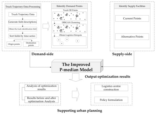
Figure 1.
Flowchart of the proposed methodology.
3.2. Extraction of Truck Original and Destination Points Based on Truck Trajectory Data
This paper uses truck trajectory data to extract truck starting and destination points in cities [35]. The truck trajectory data were recorded by the positioning device installed on the truck, which contains some key information such as time, geographic location, speed, direction, and mileage of the truck. The structure of the truck trajectory data is shown in Table 1, and the example of truck trajectory data is shown in Table 2.

Table 1.
Structure of the truck trajectory data.

Table 2.
Example of truck trajectory data structure.
The truck trajectory data are processed based on the internal characteristics of the data. The processing steps are as follows [48]: (1) define each field based on the structure of the data for field description; (2) categorize and process the data according to the ID of the truck to obtain data for each truck in the time period; (3) arrange each truck based on the time order; (4) match the arranged trajectory with the vector road network to obtain truck trajectory data.
During data processing, the characteristics of the data are analysed as follows: (1) the volume of data is large; the number of truck tracking records in Hubei Province in a week is more than 800,000. (2) The truck positioning devices rely on Beidou and GPS positioning systems, and they are influenced by extreme weather, geological environment, and other multi-factor interference. Thus, data loss may appear, and the positioning data are unstable. (3) Some records are duplicated. Vehicle parking and traffic jams affect the determination of the starting point and destination point during data analysis.
Based on the related literature, data cleaning and pre-processing will be conducted. First, the points with a speed greater than 120 km/h are screened out. Then, for the historical data of stopping and unloading of lorries, the maximum stopping time is chosen as 20 min (if the time interval of two trajectories is less than 20 min, they are regarded as one trajectory) [38]. Finally, if the truck moves at a speed less than 5 km/h, the corresponding data point is filtered out to identify potential vehicle stops.
The data are pre-processed in Python to extract the key starting and destination points of the trucks in operation. Meanwhile, the non-conformity and missing data are also screened in the process. Based on this, the extracted starting and destination points of the trucks can be used to identify the largest areas of the city more accurately in terms of freight transport.
3.3. Using the DBSCAN Clustering Algorithm to Obtain Freight Demand in Cities
In this paper, the DBSCAN clustering algorithm is adopted to mine and analyse the starting and destination points of trucks to identify the travel hotspots and locate the areas with high logistics demand in the city. The DBSCAN clustering algorithm involves two important parameters, and [45].
By continuously adjusting the parameters, the maximum set of starting and destination points of a truck connected by the density in the urban space is divided into clusters. is the domain of point given a radius ; is the minimum number of points in the neighbourhood of given a point , and this point is the core point.
The main process of the DBSCAN clustering algorithm is as follows: starting with a point in the point set , if the neighbourhood of contains more than points, then is the core point. In this case, a cluster including point is created, and the points with direct density reachable to this cluster are added to its neighbourhood. Then, the above execution is repeated for all the points in the obtained cluster. As such, each data point is considered to be of crucial importance and is not ignored in the DBSCAN clustering process. Meanwhile, the points that do not belong to any of the clusters are identified and filtered out finally, and these points are called noisy points. These noisy points are not in any clusters, they are isolated data points.
It can be seen that the selection of a suitable parameter for the DBSCAN clustering algorithm is crucial for improving data analysis accuracy. This paper refers to the method proposed by Tang [46] to determine the optimal parameter.
3.4. Optimal Site Selection Based on an Improved P-Median Site Selection Model
The P-median problem was introduced by Hakimi in 1964, which aims to minimize the total weighted cost of travel (distance, time, cost, etc.) for customers to reach the facility [14]. The core of the P-median model is to ensure that each demand point is linked to the corresponding supply point and the total weighted cost of the demand point is minimized. This model is usually applied to the location of warehouses and logistics centres. Given that logistics is a cost-sensitive industry, the P-median site selection model is exploited in this paper.
The traditional mathematical formulation of the P-median model can be divided into the objective function and constraint function [33].
- (1)
- Objective function
The objective function ensures that the layout result minimizes the weighted distance from each demand point to the facility provided that the constraint function is satisfied. The calculation of the objective function is shown as follows:
where is the weighted distance factor; M is the set of demand points, M = {1,2,…,m}; N is the set of candidate facility points, N = {1,2,…,n}; is the demand of demand point (in this paper, the truck travel hotspot is selected as the demand point); is the travel cost (distance, time, cost, etc.) between demand point and facility point ; and is the service relationship between facility point and demand point .
- (2)
- Constraint functions
Constraint-limited decision variables and are obtained from the siting and service relationships, where indicates the siting relationship for facility point , and indicates the service relationship between facility point and demand point . Both variables are integer, and they are denoted as:
When takes 1, it means that there is a facility setup at location ; when takes 0, it means that there is no facility setup at location .
When takes 1, it means that facility serves demand point ; when takes 0, it means that facility does not serve demand point .
The number of configurable facilities is determined based on the candidate layout points, and the constraint relationship can be expressed as:
where is the number of new logistics centre facilities.
To ensure that each demand point can be allocated to a location served by a logistics centre as a function of
the following condition should be satisfied:
It can be seen that the P-median model only considers the travel efficiency, and the data distribution follows the proximity distribution. Moreover, the model tends to select the facilities in remote areas as optimization results, which usually serve a few demand points. In this case, the distribution pattern of the whole space will have the problem of inequity. Meanwhile, the trajectory data reveals that truck drivers tend to choose the closest route while transporting goods. This suggests that the willingness of demand points to choose facility points decreases as the distance increases.
Actually, in urban development, the freight demands tend to be bifurcated, and the areas with a greater demand for freight become more concentrated [49]. In some areas with a large number of truck trips, this leads to a reduction in service levels in logistics centres due to the limited space and service capacity of local logistics centres. Therefore, it is necessary to improve the P-median model to take the size of facility capacity into consideration. To this end, this paper improves the P-median optimisation model based on the methods proposed by relevant studies [50].
This paper makes an improvement based on the idea of the Huff’s model, which was designed to analyse consumers’ willingness to choose shopping centres and was first used to analyse shopping areas [51]. Considering the relationship between the logistics supply and demand by truck trajectories data, this paper adds a distance attenuation parameter to the travel cost . The travel cost for areas further away is increased by the distance attenuation parameter . Then, considering the constraints on the peak capacity for simultaneous delivery of goods of the logistics centre, this paper introduces the variable to represent the capacity of the facility. Finally, this paper adds maximum travel distance . Based on the above description, the objective function of the improved P-median model is expressed as follows:
Meanwhile, the new constraints are added as follows:
where and denotes the minimum and maximum capacity of the facility, respectively. This paper performs site selection and optimization based on the above constraints.
4. Study Area and Data Pre-Processing
4.1. Study Area
To verify the proposed optimisation model, this paper chooses the city of Wuhan as an example to explore the location of a logistics centre. Wuhan is in the central region of China, and it is the capital city of Hubei Province in China. By the end of 2021, the city had 13 districts with a total area of 85,691,500 square kilometres and a resident population of 13,648,900. Wuhan is known as the “thoroughfare of nine provinces”, and the city has the largest inland water, land, and air transportation hub, and the shipping centre in the middle reaches of the Yangtze River. In addition, it is the only city in central China with direct flights to five continents worldwide.
Currently, the construction of various logistics transportation hubs and logistics centres in Wuhan is relatively complete, and the logistics industry has become a pillar industry in Wuhan. However, it does not have much advantage compared with the surrounding areas, and in the city development, there are problems such as mismatch between logistics space supply and demand, relocation and replacement of logistics land, and slow development of logistics economy. From the perspective of the layout of logistics centres, the logistics centres in Wuhan are relatively scattered, showing the overall layout characteristics of “strong in the north of the river and weak in the south”. Extensive research indicates that the layout characteristics have led to high logistics transportation costs [52].
Therefore, this paper selects Wuhan city as the research area to investigate the optimal layout of logistics centres based on the optimisation model. The research area for this paper is shown in Figure 2 as follows.
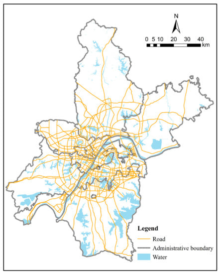
Figure 2.
Study area.
4.2. Data Pre-Processing
This study takes the full-day freight truck trajectory data from December 10 to 16, 2018 in Wuhan, Hubei Province for analysis. After preliminary data processing, a total of 49,813 trucks and 213,500 truck stopping points are obtained within the period from 10 December 2018, to 16 December 2018, in Wuhan city.
This paper implements the DBSCAN spatial clustering algorithm on these data points based on the ArcGIS platform combined with the Python programming language. The key parameters and of the DBSCAN spatial clustering algorithm will be determined by the iterative process, as shown in Figure 3. As the parameter increases, the number of clusters will first increase to a critical value, and then will gradually decrease. As the parameter increases, the number of clusters decreases gradually. When , the number of clusters increases as the increases and will tend to stabilise. When ,, a maximum number of clusters exists at this point, after which it will gradually decrease.
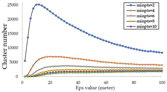
Figure 3.
Cluster numbers under different parameters.
The algorithm parameters are set through iterative calculations: neighbourhood radius and cluster minimum points . Based on the spatial coordinates of each point, a total of 2410 clusters were identified in the study range. The geometric centroids of the remaining clusters were then substituted into the entire cluster to accurately locate the areas of the city with high logistics demand. This process is illustrated in Figure 4 below. To represent the spatial distribution pattern more intuitively, this paper adopts the ArcGIS platform for kernel density analysis and visualisation.
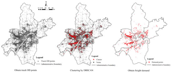
Figure 4.
The process of identifying demand points.
As shown in Figure 5, the demand for logistics in Wuhan is polarised: the areas in the south of the Yangtze River have fewer logistics demands, and the areas at the north of the Yangtze River have more logistics demands. Meanwhile, the areas with high logistics demand in Wuhan are in several concentrated and contiguous regions, mainly in the Dongxihu District, Hannan District, and Qinshan District. These are administrative districts with a strong industrial manufacturing sector, which indicates that the areas with high logistics demand are related to industrial development.
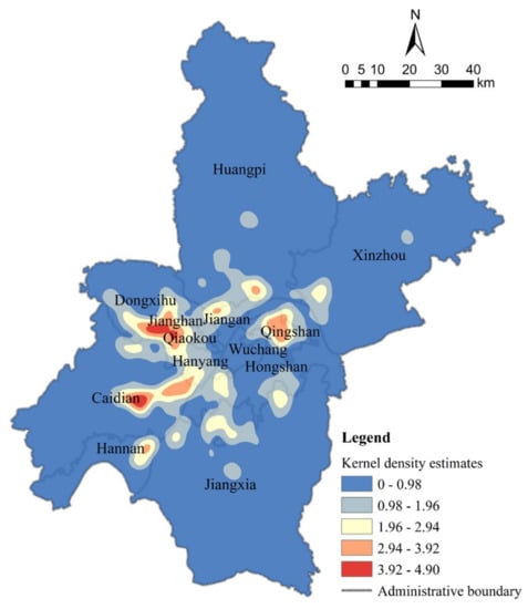
Figure 5.
Kernel density analysis results of the freight demand in Wuhan.
4.3. Model Constraints
- (1)
- The sets of supply points (N) and demand points (M). Supply point N indicates the set of planned logistics storage land and current logistics centres in Wuhan, and there are 23 of them. As of 2021, this paper takes the logistics centres in the previous Wuhan logistics spatial layout plan as the current logistics centres, and there are 14 logistics centres. Meanwhile, the planned and unbuilt logistics and warehousing sites in Wuhan City are selected as alternative locations, and there are 9 locations in total. Taking the current logistics centres and alternative logistics and warehousing sites in Wuhan as alternative locations for the experiment, 23 candidate locations are finally identified, and their spatial distribution and facility scale are shown in Figure 6, Table 3 and Table 4. Through our analysis, we obtained a total of 2410 clusters based on the DBSCAN cluster analysis and pre-processing of freight starting and destination points. In this paper, the geometric centroids of the clusters are extracted. They are considered as the areas in the city with high logistics demand and then used as demand points in the freight model. As a result, the set M includes 2410 demand points, whose spatial distribution is shown in Figure 7.
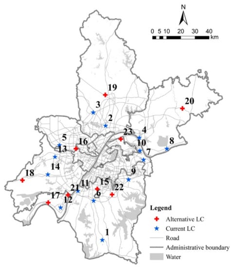 Figure 6. The distribution of logistics supply facilities in Wuhan.
 Table 3. The current logistics centres in Wuhan.
 Table 4. The alternative facilities in Wuhan.
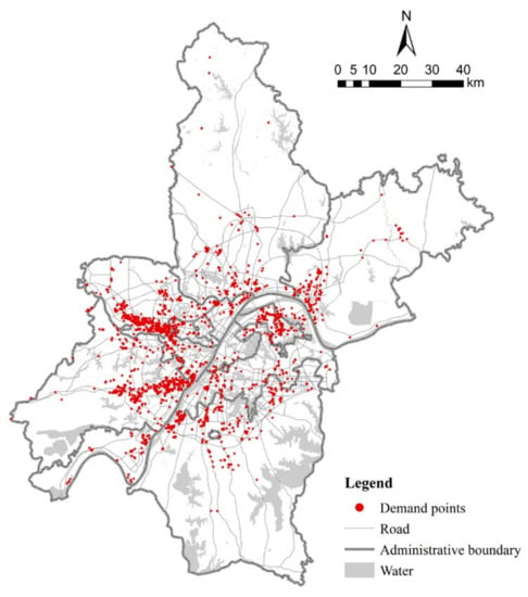 Figure 7. The distribution of the logistics demand points in Wuhan.
 - (2)
- Number of facilities P with alternative points. To facilitate the analysis of the results before and after the layout optimization, the number of facilities P determined in this paper is still 14. The alternative points are selected as alternative locations for the planned and unbuilt logistics and warehousing sites in Wuhan, and there are 9 locations in total.
- (3)
- Road network dataset and travel costs . Through the analysis of trajectory data and in combination with the related literature, the trucks usually have a road transport-based travel mode, and the travel cost is measured by travel distance in km. This paper combines the vector data of highways, main roads, and secondary roads in Wuhan to construct a network dataset and establish topological relationships. As shown in Figure 8, the paper is based on the actual road network distances for the location of the logistics centre. In the existing layout plan, the average travel distance from the demand point to each logistics centre facility point in the city is 11.11 km, the maximum travel distance is 52.54 km, and the minimum travel distance is 0.03 km. Considering the average travel distance and the actual situation of the city, the maximum travel distance used in the model is 35 km.
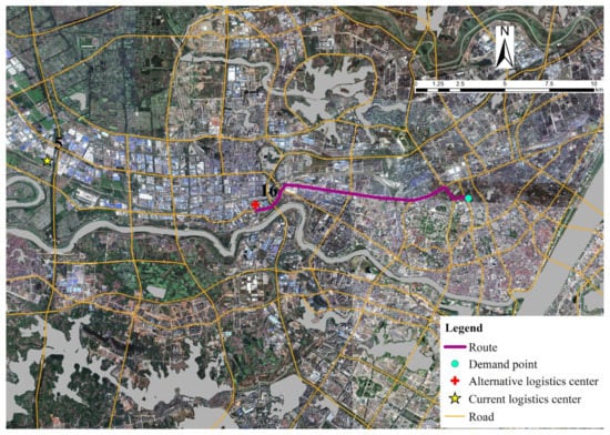 Figure 8. Selection of the nearest LCS based on distance from the road network.
 - (4)
- The service capacity of the facility Q. In practice, the service capacity of logistics facilities is limited by their sizes. Through the research of the current logistics centre in Wuhan, the maximum service capacity is selected to be no more than 15% of the total, and the minimum service capacity is no less than 1% of the total. In summary, the maximum capacity parameter is set to 360, and the minimum capacity parameter is set to 24 in this paper.
- (5)
- Impedance coefficient . To determine the value of , this paper makes an accurate fit for the behavioural way of the demand point, and the results show that when , the behaviour of truck travel can be better represented, and the model results are more in line with the actual situation.
5. Experiment and Results
5.1. Site Optimization Results
Since solving the P-median siting model is a typical NP-hard problem [53], the solution to the model cannot be directly obtained. In this paper, the heuristic algorithm is adopted to solve the P-median siting model, and the network analysis function of the ArcGIS platform is exploited to obtain a feasible solution under the specified constraints, which is used to store and display vector data, including transportation network, freight track trajectory data, land use in Wuhan, and other data. The processing and mining of the above data in this paper and the results are shown in Figure 9, Figure 10, Figure 11 and Figure 12, respectively.
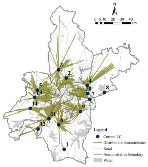
Figure 9.
Site location and allocation results for current logistics centres by the P-median method.
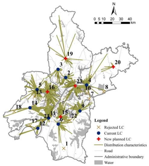
Figure 10.
Site location and allocation results by the P-median method.
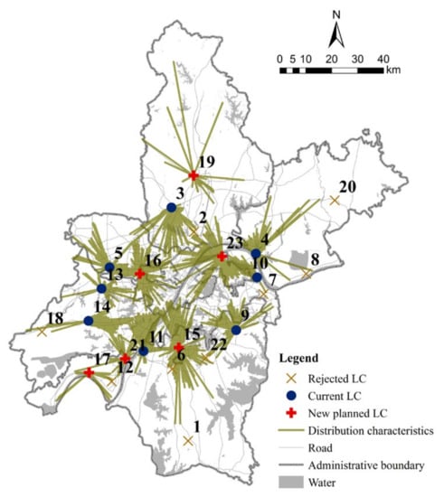
Figure 11.
Site location and allocation results by the improved P-median method.
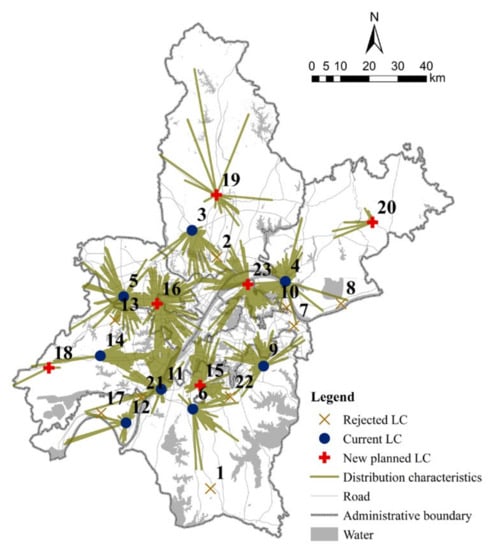
Figure 12.
Site location and allocation results by the P-center model.
The experimental results of this paper are shown above. Figure 9 shows the results of the site selection and allocation by using the P-median model for the current logistics facilities. It represents the result before optimization. Figure 10, Figure 11 and Figure 12 show the results of the optimal siting of alternative and current logistics facilities. These results are, respectively, obtained based on the P-median model, the improved p-median model, and the maximized coverage model. To compare the experimental results more conveniently, in this paper, the experimental results above are denoted as models 1, 2, 3, and 4, as shown in Table 5. Model 1 shows the results before optimization; models 2 and 3 are designed to compare the experimental results of the improved P-median method; model 4 is a site selection method based on the coverage model and is used for comparison with the P-median method.

Table 5.
Abbreviation for experimental results.
5.2. Analysis of the Characteristics before and after Optimization
By comparing and evaluating the layout before and after optimisation, the following observations can be made.
- (1)
- Newly sited logistics centres are mostly located in areas with good accessibility and high freight demand.
By analysing the results above, the logistics centres 1, 7, and 8 were not sited after optimisation. The spatial layout of them is mostly located in the periphery of the city, and the travel cost of trucks to them is large. Furthermore, there is less demand for logistics in the vicinity. Meanwhile, in the newly planned logistics centres, 15, 16, and 23 are marked as selected logistics parks. These logistics centres are located on the outskirts of urban areas with good accessibility to the surrounding areas and complete facilities. As a result, goods can be distributed quickly to the inner city and to the surrounding industrial estates.
- (2)
- The travel cost of trucks has a greater impact on the siting of the logistics facility location, and the travel cost after optimisation is smaller than that before optimisation.
Based on the optimization results of the site location model for truck travel costs, this paper analyses the percentage of each distance of goods transported at the demand point, and the analysis result is shown in Figure 13. The main indicators of the experimental results regarding the cost of van travel are presented in Table 6. It can be seen that, with the inclusion of new alternative points, lorry travel costs will be lower. Models 2, 3, and 4 have shorter average truck travel distances than model 1. The optimised trucking costs have been reduced by an average of 22%. Moreover, the results of model 1 are lower than those of the other three models for the coverage of freight transported within 5 km, 10 km, and 20 km. By comparing the experimental results of model 3 with those of models 2 and 4, model 3 was not as good as the other two models in terms of trucking distances, travel coverage, and the proportion of demand points for services, but the discrepancy was not significant. The results show that optimisation can greatly reduce the travel cost and the waste of resources while maintaining the same number of facilities in the logistics centre.
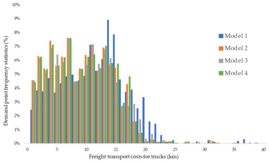
Figure 13.
The distribution of travel distance of trucks.

Table 6.
Main indicators for comparison.
- (3)
- There is a significant reduction in the carrying capacity of the current logistics centre after optimisation, and the spatial allocation becomes more equitable.
Figure 14 and Figure 15 shows the proportion of demand points served by the logistics centres before and after optimisation. It can be seen from Figure 14 that the curve of the demand points served by the logistics centres after optimisation is smoother than that before optimisation. The growth curve for model 3 is smoother than that of the other three models. Additionally, the gap between the demand points served by each logistics centre before and after optimisation is narrowing, and the spatial distribution is more reasonable. By comparing model 3 with the other three models, it can be seen that the number of demand points served by some logistics centres significantly decreases. In model 3, the largest logistics centres serve 15% of the freight demand, and the other models serve 24.6%, 20.6%, and 20.8% of the freight demand, respectively. As a result, the average number of demand points served by the optimised logistics centres is more evenly distributed, which is a significant improvement over the previous polarised situation and significantly alleviates the low service efficiency of the current logistics centre.
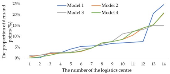
Figure 14.
Changes in the proportion of demand points served by the logistics centre before and after optimisation.
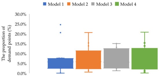
Figure 15.
Changes in the proportion of demand points served by the logistics centre before and after optimization (box plots).
6. Discussion of the Optimisation Results
This paper proposes a new method for the location and allocation of logistics centres based on truck trajectory data. The improved P-median model based on the relationship between the logistics supply and demand is proposed by introducing the logistics service demand from industry and urban resident’s daily life and adding a restricted condition for logistics supply peak capacity. After optimisation, the spatial distribution of logistics centres in the city is more reasonable, shown in Figure 14 and Figure 15 and in Table 6, which reduces the transportation cost and the flows of goods in urbanized areas by the UFT vehicle.
6.1. Discussion from the Perspective of the Logistics Centres’ Administrator
Logistics centres are usually located in the areas with high freight volumes, which is consistent with the result in our study as well. In practice, however, logistics centres vary in size and service level, and often the limited carrying capacity of some logistics centres in cities leads to a large concentration of trucks in the vicinity, thus reducing the service efficiency. It was found that the number, size, and quality of logistics facilities positively influence export flows [54].
Because trucks do not turn off when loading and unloading goods, the inefficient distribution processing of the logistics centres will increase energy consumption and greenhouse gas emissions. This shows that the location of logistics centres needs to consider not only the quantity of logistics centres, but also their quality (the peak capacity for simultaneous delivery of goods of the logistics centre). With the development of the current big data, cloud computing, Internet of Things, and other technologies [55], constructing intelligent logistics centres and managing logistics centres scientifically has become the main direction of future development.
6.2. Discussion from the Perspective of Policymakers
Firstly, the demand for logistics will change with the development of the city’s economy, which indicates that the demand for logistics and the changes in logistics centres is in a dynamic and continuous process. Policymakers need to pay more attention to the current operation of logistics centres and develop corresponding management measures to improve the use efficiency of logistics. Furthermore, it is suggested to conduct a survey on the logistics situation of the city and evaluate the function of logistics centres scientifically and reasonably. Based on this, the supply and demand balance of urban logistics and the sustainable development of logistics centres can be ensured. In this paper, taking Wuhan as an example, there are a total of 49,813 trucks and 213,500 truck stopping points obtained to describe and evaluate the function of logistics centres in a scientific and reasonable manner. The bottom-up perspective by truck trajectories data is regarded as an effective mean to investigate the status quo for logistics. In particular, practitioners of urban planning and transportation and freight planning will benefit from this investigation approach.
Secondly, the layout of logistics centres is the result of a multi-party game, and many factors need to be considered such as location, land price, surrounding facilities, ecological impact, and so on. This paper provides a scientific basis for the location of urban logistics centres from the perspective of cost minimisation, which is different from the previous research. For those logistics centres that are not selected by the developed model, an in-depth study needs to be conducted on these logistics centres. Some logistics centres that are not in line with the current stage of development are updated on time, while new logistics centres are reasonably arranged in some new areas to improve the land-use efficiency and promote the rational allocation of resources.
Finally, the logistics industry is an industry that is heavily dependent on transport conditions. The development of this industry cannot be achieved without transport infrastructures such as roads, railways, and waterways. This study finds that despite the large scale of some logistics centres, their remote location makes it difficult for the demand points to be served easily, which indicates that the accessibility of the logistics centres directly affects their selection by the model. This requires policymakers to consider arranging the transport infrastructure around logistics centres and constructing dedicated transport links for freight transport. This will be achieved through the continuous improvement of traffic conditions to meet the various freight needs of the city.
6.3. Discussion of the Results Achieved from the Current Study
This study is based on candidate logistics centres provided by the government, as well as on existing logistics centres as supply facilities. These candidate areas were identified by the government after considering land use restrictions, environmental concerns, and economic factors. Given the increasing land use constraints in cities, it is impossible to build new logistics centres in all candidate areas. Based on this, this paper uses truck trajectory data to obtain specific freight demand areas in the city to evaluate these candidate and existing logistics centres. As a result of the evaluation, the areas that were marked as logistics centres to be built before and after optimisation should be retained. For the other existing logistics centres that are not selected, an extensive and comprehensive assessment should be carried out to provide scientific support for the subsequent demolition or retention of these areas. The aim of this paper is to present a replicable methodology to assess the siting optimisation of logistics centres in major cities and to provide a scientific basis for further planning.
This paper has some drawbacks in practice, which will be further studied in the subsequent research: (1) firstly, the service level and capacity of logistics centres are not quantified uniformly in this paper, and the willingness of truck drivers to choose logistics centres is related to the service level and capacity of logistics centres. Due to the lack of key data, this paper fails to study this point in-depth, and a more detailed study will be conducted later. (2) This paper evaluates the development of logistics centres and measures the current optimization strategies of logistics parks based on the current data. In fact, the development of logistics centres and freight demand will change over time, and more and more advanced technologies need to be adopted to assess the potential carrying capacity of logistics centres in the future. (3) Urban logistics is an axial-spoke multi-layered system, and given the hierarchical relationship between various logistics centres, the future method of siting logistics centres based on truck trajectory data will also need to make a breakthrough in this area.
7. Conclusions
The urban logistics industry is a key link between a city and other cities to promote the economic and sustainable development of the city [56]. A country’s ability to provide high-quality transport infrastructure and logistics is a source of comparative advantage in the logistics intensive industries [57]. Moreover, the urban logistics industry is the basis for promoting the exchange of urban resources. The development of the logistics industry cannot be achieved without the use of land for logistics facilities. However, these logistics facilities typically occupy a large area within the city, which results in low land use efficiency and disturbance to the surrounding residents. As a result, logistics centers often need to be relocated during the urban development process. In the latest urban planning in China, under the guidance of safeguarding the industrial and human environment of the city, the scale of urban growth is strictly controlled, and there are fewer and fewer land resources available for the logistics industry in the city. To this end, this paper focuses on the operational efficiency and equity of logistics centres. Considering that land is a decisive factor in the development of the logistics industry in cities, it is crucial to investigate the layout and planning of land for logistics centres. Under the condition of tight land resources, this paper addresses the issues of logistics centre site selection and rational spatial allocation of land resources to optimise the spatial equity and efficiency of logistics centres, as well as truck travel costs.
To achieve the above objectives, this paper extracts the key features from the truck trajectory data in the city and conducts an optimisation study on the location of urban logistics centres based on the improved P-median model from the perspective of urban logistics space supply and demand balance. To validate the effectiveness of the model, this paper selects Wuhan, a logistics hub in China, as an example, and optimises the locations of the current logistics centres in Wuhan. By analysing the results before and after the optimisation, more equitable spatial allocation of logistics centres, lower truck travel costs, and more uniform logistics centre services are achieved, which alleviates the current situation of tight land resources in the city and provides a scientific basis for the construction of logistics centres. In conclusion, (1) this paper aims to address the urban logistics centre location problem by using DBSCAN clustering, an improved P-median model, and incorporating the truck trajectory data; (2) the proposed method is implemented on Wuhan, China, as a case study. Some targeted suggestions have been provided to the logistics centres’ administrator and policymakers for improving the sustainable development of the logistics transportation.
Author Contributions
Conceptualization, Hongzan Jiao; methodology, Hongzan Jiao and Faxing Yang; software, Faxing Yang; validation, Hongzan Jiao and Faxing Yang; formal analysis, Faxing Yang; investigation, Hongzan Jiao; resources, Hongzan Jiao; data curation, Shibiao Huang and Faxing Yang; writing—original draft preparation, Faxing Yang; writing—review and editing, Hongzan Jiao and Faxing Yang; visualization, Shasha Xu; supervision, Hongzan Jiao; project administration, Hongzan Jiao; funding acquisition, Hongzan Jiao All authors have read and agreed to the published version of the manuscript.
Funding
This research was funded by the National Natural Science Foundation of China Major Program (Grant Nos. 42192580 and 42192583), the National Key Research and Development Program (2020YFC1512002) and Spatial Layout Plan project of Modern Logistics in Wuhan (2022–2035).
Data Availability Statement
Not applicable.
Conflicts of Interest
The authors declare that there is no conflict of interest.
References
- Kin, B.; Verlinde, S.; Macharis, C. Sustainable Urban Freight Transport in Megacities in Emerging Markets. Sustain. Cities Soc. 2017, 32, 31–41. [Google Scholar] [CrossRef]
- Khan, S.A.R.; Zhang, Y.; Kumar, A.; Zavadskas, E.; Streimikiene, D. Measuring the Impact of Renewable Energy, Public Health Expenditure, Logistics, and Environmental Performance on Sustainable Economic Growth. Sustain. Dev. 2020, 28, 833–843. [Google Scholar] [CrossRef]
- Rao, C.; Goh, M.; Zhao, Y.; Zheng, J. Location Selection of City Logistics Centers under Sustainability. Transp. Res. Part D Transp. Environ. 2015, 36, 29–44. [Google Scholar] [CrossRef]
- Kiba-Janiak, M. Urban Freight Transport in City Strategic Planning. Res. Transp. Bus. Manag. 2017, 24, 4–16. [Google Scholar] [CrossRef]
- Coulombel, N.; Dablanc, L.; Gardrat, M.; Koning, M. The Environmental Social Cost of Urban Road Freight: Evidence from the Paris Region. Transp. Res. Part D Transp. Environ. 2018, 63, 514–532. [Google Scholar] [CrossRef]
- Montwiłł, A.; Pietrzak, O.; Pietrzak, K. The Role of Integrated Logistics Centers (ILCs) in Modelling the Flows of Goods in Urban Areas Based on the Example of Italy. Sustain. Cities Soc. 2021, 69, 102851. [Google Scholar] [CrossRef]
- Rimiene, K.; Grundey, D. Logistics Centre Concept through Evolution and Definition. Inz. Ekon. Eng. Econ. 2007, 54, 87–95. [Google Scholar]
- Aljohani, K.; Thompson, R.G. Impacts of Logistics Sprawl on the Urban Environment and Logistics: Taxonomy and Review of Literature. J. Transp. Geogr. 2016, 57, 255–263. [Google Scholar] [CrossRef]
- Dablanc, L.; Ogilvie, S.; Goodchild, A. Logistics Sprawl: Differential Warehousing Development Patterns in Los Angeles, California, and Seattle, Washington. Transp. Res. Rec. 2014, 2410, 105–112. [Google Scholar] [CrossRef]
- Chen, Y.; Qu, L. Evaluating the Selection of Logistics Centre Location Using Fuzzy MCDM Model Based on Entropy Weight. In Proceedings of the WCICA 2006: Sixth World Congress on Intelligent Control and Automation, Dalian, China, 21–23 June 2006; IEEE: New York, NY, USA, 2006; Volumes 1–12, pp. 7128–7132. [Google Scholar]
- Stevic, Z.; Veskovic, S.; Vasiljevic, M.; Tepic, G. The Selection of the Logistics Center Location Using Ahp Method. In Proceedings of the 2nd Logistics International Conference, Belgrade, Serbia, 21–23 May 2015; Vidovic, M., Kilibarda, M., Zecevic, S., Miljus, M., Radivojevic, G., Eds.; Univiversity Belgrade, Faculty of Transport and Traffic Engineering: Belgrade, Serbia, 2015; pp. 86–91. [Google Scholar]
- Wang, S.; Liu, P. The Evaluation Study on Location Selection of Logistics Center Based on Fuzzy AHP and TOPSIS. In Proceedings of the 2007 International Conference on Wireless Communications, Networking and Mobile Computing, Shanghai, China, 21–25 September 2007; IEEE: New York, NY, USA, 2007; Volumes 1–15, pp. 3779–3782. [Google Scholar]
- Owen, S.H.; Daskin, M.S. Strategic Facility Location: A Review. Eur. J. Oper. Res. 1998, 111, 423–447. [Google Scholar] [CrossRef]
- Hakimi, S. Optimum Locations of Switching Centers + Absolute Centers + Medians of Graph. Oper. Res. 1964, 12, 450. [Google Scholar] [CrossRef]
- Peng, P.; Snyder, L.V.; Lim, A.; Liu, Z. Reliable Logistics Networks Design with Facility Disruptions. Transp. Res. Pt. B Methodol. 2011, 45, 1190–1211. [Google Scholar] [CrossRef]
- Döyen, A.; Aras, N.; Barbarosoğlu, G. A Two-Echelon Stochastic Facility Location Model for Humanitarian Relief Logistics. Optim. Lett. 2012, 6, 1123–1145. [Google Scholar] [CrossRef]
- Amin, S.H.; Zhang, G. A Multi-Objective Facility Location Model for Closed-Loop Supply Chain Network under Uncertain Demand and Return. Appl. Math. Model. 2013, 37, 4165–4176. [Google Scholar] [CrossRef]
- Tofighi, S.; Torabi, S.A.; Mansouri, S.A. Humanitarian Logistics Network Design under Mixed Uncertainty. Eur. J. Oper. Res. 2016, 250, 239–250. [Google Scholar] [CrossRef]
- Hua, X.; Hu, X.; Yuan, W. Research Optimization on Logistics Distribution Center Location Based on Adaptive Particle Swarm Algorithm. Optik 2016, 127, 8443–8450. [Google Scholar] [CrossRef]
- Zhang, B.; Li, H.; Li, S.; Peng, J. Sustainable Multi-Depot Emergency Facilities Location-Routing Problem with Uncertain Information. Appl. Math. Comput. 2018, 333, 506–520. [Google Scholar] [CrossRef]
- Pan, J.-S.; Song, P.-C.; Chu, S.-C.; Peng, Y.-J. Improved Compact Cuckoo Search Algorithm Applied to Location of Drone Logistics Hub. Mathematics 2020, 8, 333. [Google Scholar] [CrossRef]
- Uyanik, C.; Tuzkaya, G.; Kalender, Z.T.; Oguztimur, S. An Integrated Dematel-If-Topsis Methodology for Logistics Centers’ Location Selection Problem: An Application for Istanbul Metropolitan Area. Transport 2020, 35, 548–556. [Google Scholar] [CrossRef]
- Kieu, P.T.; Nguyen, V.T.; Nguyen, V.T.; Ho, T.P. A Spherical Fuzzy Analytic Hierarchy Process (SF-AHP) and Combined Compromise Solution (CoCoSo) Algorithm in Distribution Center Location Selection: A Case Study in Agricultural Supply Chain. Axioms 2021, 10, 53. [Google Scholar] [CrossRef]
- Huang, Y.; Wang, X.; Chen, H. Location Selection for Regional Logistics Center Based on Particle Swarm Optimization. Sustainability 2022, 14, 16409. [Google Scholar] [CrossRef]
- Xi-feng, T.; Hai-jun, M.; Xu-hong, L. Logistics Facility Location Model Based on Reliability within the Supply Chain. In Proceedings of the 2008 4th IEEE International Conference on Management of Innovation and Technology, Bangkok, Thailand, 21–24 September 2008; IEEE: Bangkok, Thailand, 2008; pp. 1099–1103. [Google Scholar]
- Gan, M.; Li, D.; Wang, M.; Zhang, G.; Yang, S.; Liu, J. Optimal Urban Logistics Facility Location with Consideration of Truck-Related Greenhouse Gas Emissions: A Case Study of Shenzhen City. Math. Probl. Eng. 2018, 2018, 8439582. [Google Scholar] [CrossRef]
- Chang, L.; Zhang, H.; Xie, G.; Yu, Z.; Zhang, M.; Li, T.; Tian, G.; Yu, D. Reverse Logistics Location Based on Energy Consumption: Modeling and Multi-Objective Optimization Method. Appl. Sci. 2021, 11, 6466. [Google Scholar] [CrossRef]
- Letnik, T.; Peruš, I.; Božičnik, S.; Mencinger, M. On Fundamental Principles of the Optimal Number and Location of Loading Bays in Urban Areas. Transport 2019, 34, 722–740. [Google Scholar] [CrossRef]
- Settey, T.; Gnap, J.; Beňová, D.; Pavličko, M.; Blažeková, O. The Growth of E-Commerce Due to COVID-19 and the Need for Urban Logistics Centers Using Electric Vehicles: Bratislava Case Study. Sustainability 2021, 13, 5357. [Google Scholar] [CrossRef]
- Heitz, A.; Launay, P.; Beziat, A. Heterogeneity of Logistics Facilities: An Issue for a Better Understanding and Planning of the Location of Logistics Facilities. Eur. Transp. Res. Rev. 2019, 11, 5. [Google Scholar] [CrossRef]
- Schilling, D.A.; Jayaraman, V.; Barkhi, R. A Review Of Covering Problems In Facility Location. Comput. Oper. Res. 1993, 1, 25. [Google Scholar]
- Hochbaum, D.S.; Pathria, A. Generalized P-Center Problems: Complexity Results and Approximation Algorithms. Eur. J. Oper. Res. 1997, 100, 594–607. [Google Scholar] [CrossRef]
- Revelle, C.; Swain, R. Central Facilities Location. Geogr. Anal. 1970, 2, 30–42. [Google Scholar] [CrossRef]
- Tong, P.; Li, M.; Li, M.; Huang, J.; Hua, X. Large-Scale Vehicle Trajectory Reconstruction with Camera Sensing Network. In Proceedings of the 27th Annual International Conference on Mobile Computing and Networking, New Orleans, LA, USA, 28 March–1 April 2022; Association for Computing Machinery: New York, NY, USA, 2021; pp. 188–200. [Google Scholar]
- Yanhong, F.; Xiaofa, S. Research on Freight Truck Operation Characteristics Based on GPS Data. In Proceedings of the Intelligent and Integrated Sustainable Multimodal Transportation Systems Proceedings from the 13th Cota International Conference of Transportation Professionals (cictp2013), Shenzhen, China, 13–16 August 2013; Zhang, L., Wei, H., Li, Z., Zhang, Y., Li, M., Eds.; Elsevier Science Bv: Amsterdam, The Netherlands, 2013; Volume 96, pp. 2320–2331. [Google Scholar]
- Sun, Z.; Ban, X. Vehicle Classification Using GPS Data. Transp. Res. Pt. C Emerg. Technol. 2013, 37, 102–117. [Google Scholar] [CrossRef]
- Oka, H.; Hagino, Y.; Kenmochi, T.; Tani, R.; Nishi, R.; Endo, K.; Fukuda, D. Predicting Travel Pattern Changes of Freight Trucks in the Tokyo Metropolitan Area Based on the Latest Large-Scale Urban Freight Survey and Route Choice Modeling. Transp. Res. Pt. E Logist. Transp. Rev. 2019, 129, 305–324. [Google Scholar] [CrossRef]
- Laranjeiro, P.F.; Merchan, D.; Godoy, L.A.; Giannotti, M.; Yoshizaki, H.T.Y.; Winkenbach, M.; Cunha, C.B. Using GPS Data to Explore Speed Patterns and Temporal Fluctuations in Urban Logistics: The Case of Sao Paulo, Brazil. J. Transp. Geogr. 2019, 76, 114–129. [Google Scholar] [CrossRef]
- Gingerich, K.; Maoh, H.; Anderson, W. Classifying the Purpose of Stopped Truck Events: An Application of Entropy to GPS Data. Transp. Res. Pt. C Emerg. Technol. 2016, 64, 17–27. [Google Scholar] [CrossRef]
- Ester, M.; Kriegel, H.-P.; Sander, J.; Xu, X. A Density-Based Algorithm for Discovering Clusters in Large Spatial Databases with Noise. In Proceedings of the Second International Conference on Knowledge Discovery and Data Mining, Portland, OR, USA, 2–4 August 1996; AAAI Press: Palo Alto, CA, USA, 1996; pp. 226–231. [Google Scholar]
- Gong, L.; Yamamoto, T.; Morikawa, T. Identification of Activity Stop Locations in GPS Trajectories by DBSCAN-TE Method Combined with Support Vector Machines. Transp. Res. Procedia 2018, 32, 146–154. [Google Scholar] [CrossRef]
- Hu, Y.; Gao, S.; Janowicz, K.; Yu, B.; Li, W.; Prasad, S. Extracting and Understanding Urban Areas of Interest Using Geotagged Photos. Comput. Environ. Urban Syst. 2015, 54, 240–254. [Google Scholar] [CrossRef]
- Li, Y.; Sun, Q.; Ji, X.; Xu, L.; Lu, C.; Zhao, Y. Defining the Boundaries of Urban Built-up Area Based on Taxi Trajectories: A Case Study of Beijing. J. Geovis. Spat. Anal. 2020, 4, 8. [Google Scholar] [CrossRef]
- Peng, Z.; Bai, G.; Wu, H.; Liu, L.; Yu, Y. Travel Mode Recognition of Urban Residents Using Mobile Phone Data and MapAPI. Environ. Plan. B Urban Anal. CIty Sci. 2021, 48, 2574–2589. [Google Scholar] [CrossRef]
- Sander, J.; Ester, M.; Kriegel, H.P.; Xu, X.W. Density-Based Clustering in Spatial Databases: The Algorithm GDBSCAN and Its Applications. Data Min. Knowl. Discov. 1998, 2, 169–194. [Google Scholar] [CrossRef]
- Tang, J.; Liu, F.; Wang, Y.; Wang, H. Uncovering Urban Human Mobility from Large Scale Taxi GPS Data. Phys. A 2015, 438, 140–153. [Google Scholar] [CrossRef]
- Kim, J.; Mahmassani, H.S. Spatial and Temporal Characterization of Travel Patterns in a Traffic Network Using Vehicle Trajectories. Transp. Res. Pt. C Emerg. Technol. 2015, 59, 375–390. [Google Scholar] [CrossRef]
- Xu, T.; Zhang, X.; Claramunt, C.; Li, X. TripCube: A Trip-Oriented Vehicle Trajectory Data Indexing Structure. Comput. Environ. Urban Syst. 2018, 67, 21–28. [Google Scholar] [CrossRef]
- Saragih, N.I.; Suprayogi; Bahagia, S.N.; Syabri, I. City Logistics for Mega City: A Conceptual Model (Case Study: DKI Jakarta). In Proceedings of the Joint International Conference on Electric Vehicular Technology and Industrial, Mechanical, Electrical, and Chemical Engineering (Icevt & Imece), Surakarta, Indonesia, 4–5 November 2015; IEEE: New York, NY, USA, 2015; pp. 178–182. [Google Scholar]
- Baldacci, R.; Hadjiconstantinou, E.; Maniezzo, V.; Mingozzi, A. A New Method for Solving Capacitated Location Problems Based on a Set Partitioning Approach. Comput. Oper. Res. 2002, 29, 365–386. [Google Scholar] [CrossRef]
- Huff, D. Defining and Estimating a Trading Area. J. Mark. 1964, 28, 34–38. [Google Scholar] [CrossRef]
- Wygonik, E.; Bassok, A.; Goodchild, A.V.; McCormack, E.D.; Carlson, D.L. Smart Growth and Goods Movement: Emerging Research Agendas. J. Urban. Int. Res. Placemaking Urban Sustain. 2015, 8, 115–132. [Google Scholar] [CrossRef]
- Cornuejols, G.; Fisher, M.; Nemhauser, G. Location of Bank Accounts to Optimize Float—Analytic Study of Exact and Approximate Algorithms. Manag. Sci. 1977, 23, 789–810. [Google Scholar] [CrossRef]
- Bensassi, S.; Márquez-Ramos, L.; Martínez-Zarzoso, I.; Suárez-Burguet, C. Relationship between Logistics Infrastructure and Trade: Evidence from Spanish Regional Exports. Transp. Res. Part A Policy Pract. 2015, 72, 47–61. [Google Scholar] [CrossRef]
- Neumann, W.P.; Winkelhaus, S.; Grosse, E.H.; Glock, C.H. Industry 4.0 and the Human Factor—A Systems Framework and Analysis Methodology for Successful Development. Int. J. Prod. Econ. 2021, 233, 1079912. [Google Scholar] [CrossRef]
- Wang, C.; Kim, Y.-S.; Kim, C.Y. Causality between Logistics Infrastructure and Economic Development in China. Transp. Policy 2021, 100, 49–58. [Google Scholar] [CrossRef]
- Park, S. Quality of Transport Infrastructure and Logistics as Source of Comparative Advantage. Transp. Policy 2020, 99, 54–62. [Google Scholar] [CrossRef]
Disclaimer/Publisher’s Note: The statements, opinions and data contained in all publications are solely those of the individual author(s) and contributor(s) and not of MDPI and/or the editor(s). MDPI and/or the editor(s) disclaim responsibility for any injury to people or property resulting from any ideas, methods, instructions or products referred to in the content. |
© 2023 by the authors. Licensee MDPI, Basel, Switzerland. This article is an open access article distributed under the terms and conditions of the Creative Commons Attribution (CC BY) license (https://creativecommons.org/licenses/by/4.0/).