


Hyperspectral Image Classification Network Based on 3D Octave Convolution and Multiscale Depthwise Separable Convolution

Abstract
:1. Introduction
- (1)
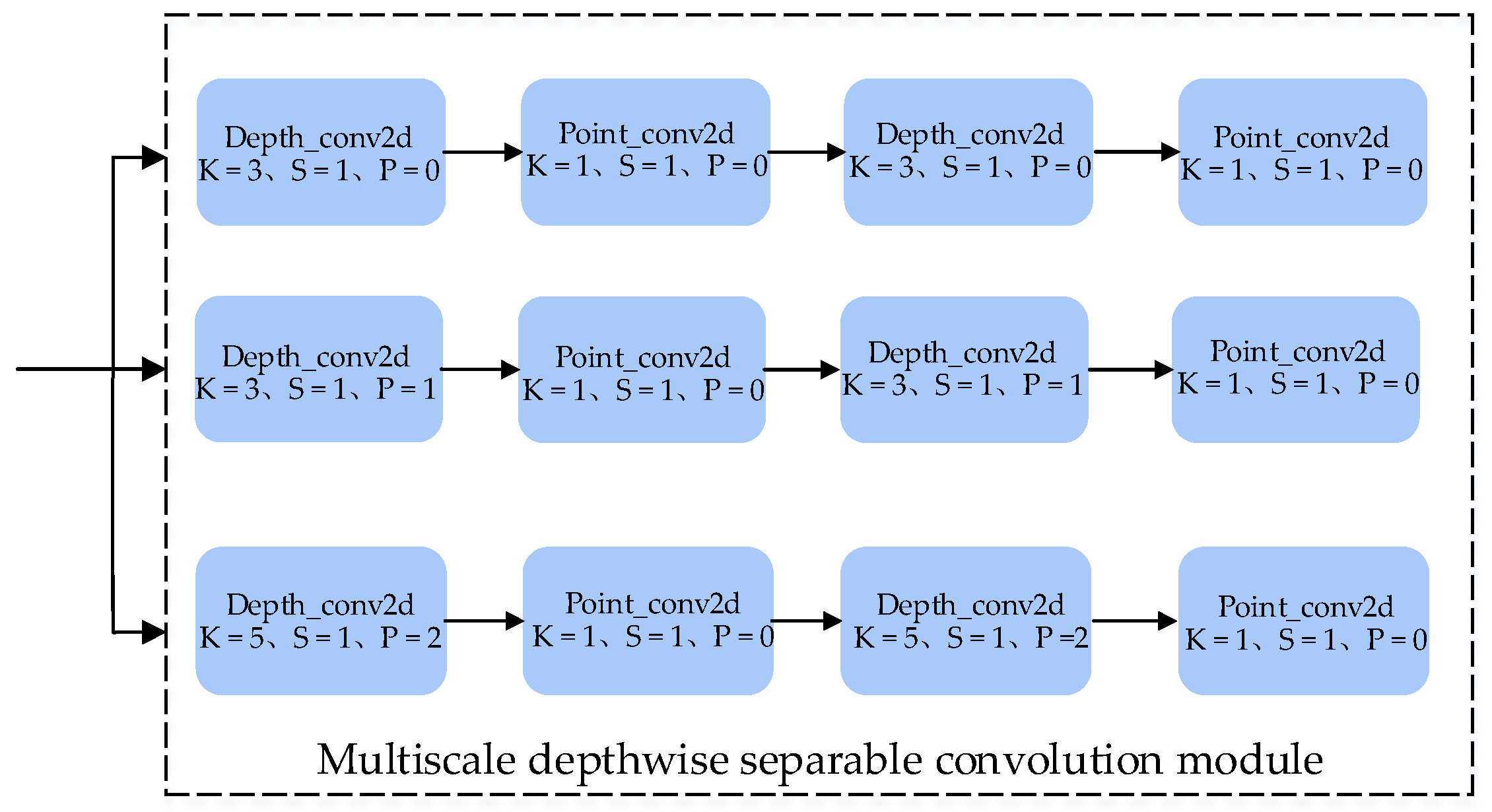
- We propose a two-layer multiscale depthwise separable convolution module for HSI classification. The module can effectively capture spatial features at various scales.
- (2)
- We design a new model that combines 3D Octave convolutions along the spectral channel with a multiscale depthwise separable convolution module to improve the HSI classification performance. Our method significantly reduces spatial redundancy and possesses a stronger capability of spectral–spatial feature extraction.
- (3)
- Our proposed OMDSC method is compared with state-of-the-art models proposed in previous research. Experimental results on three commonly used datasets, India Pines, Pavia University, and WHU-Hi-LongKou, show that our method achieves better performance in HSI classification.
2. Related Work
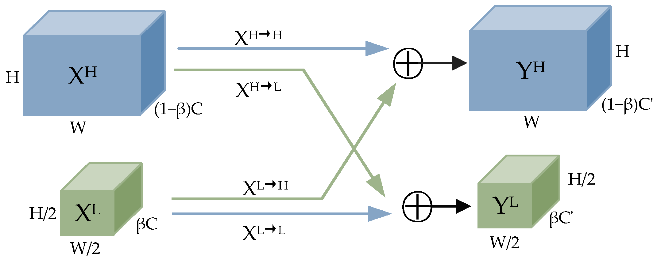
2.1. Three-Dimensional Octave Convolution Module
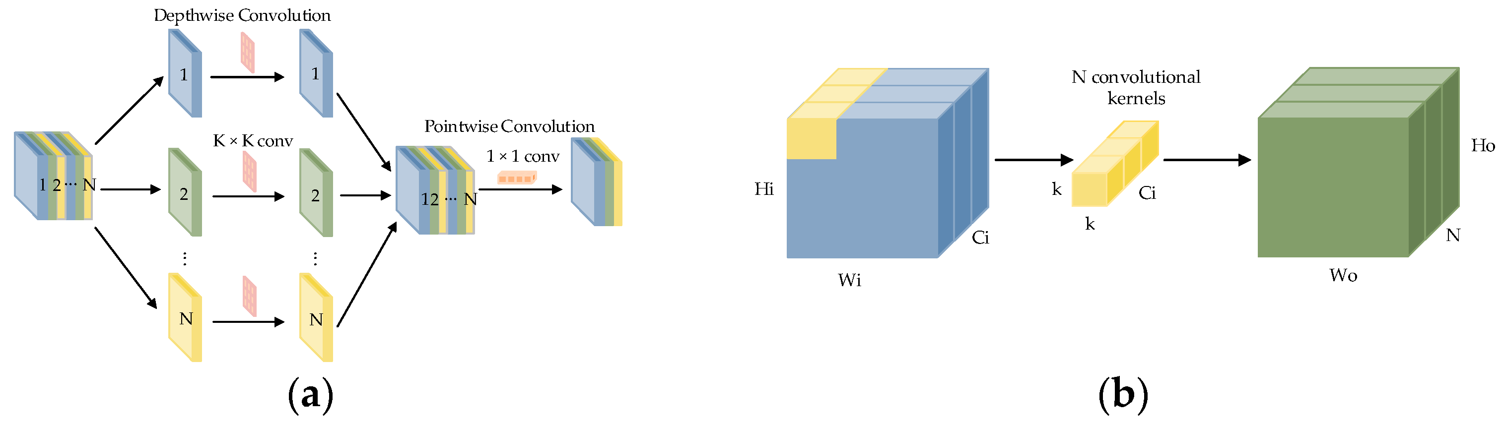
2.2. Multiscale Depthwise Separable Convolutional Module
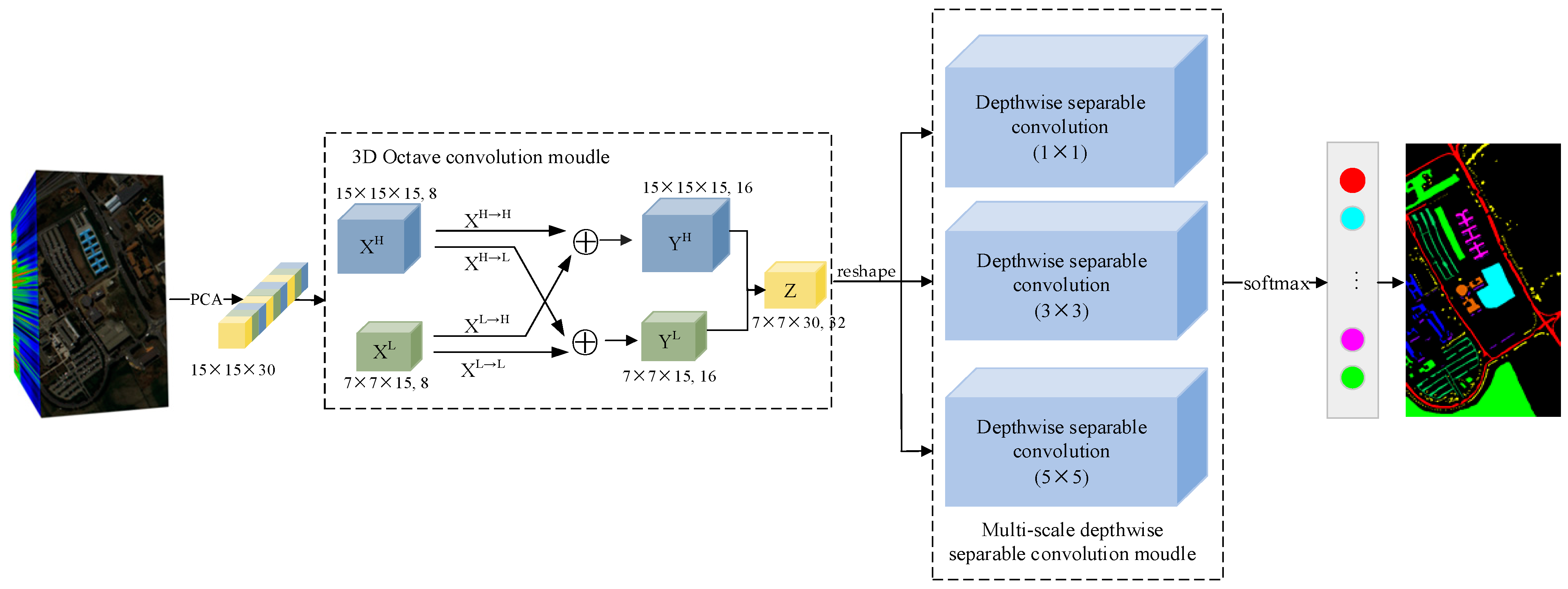
3. Method
4. Experiments
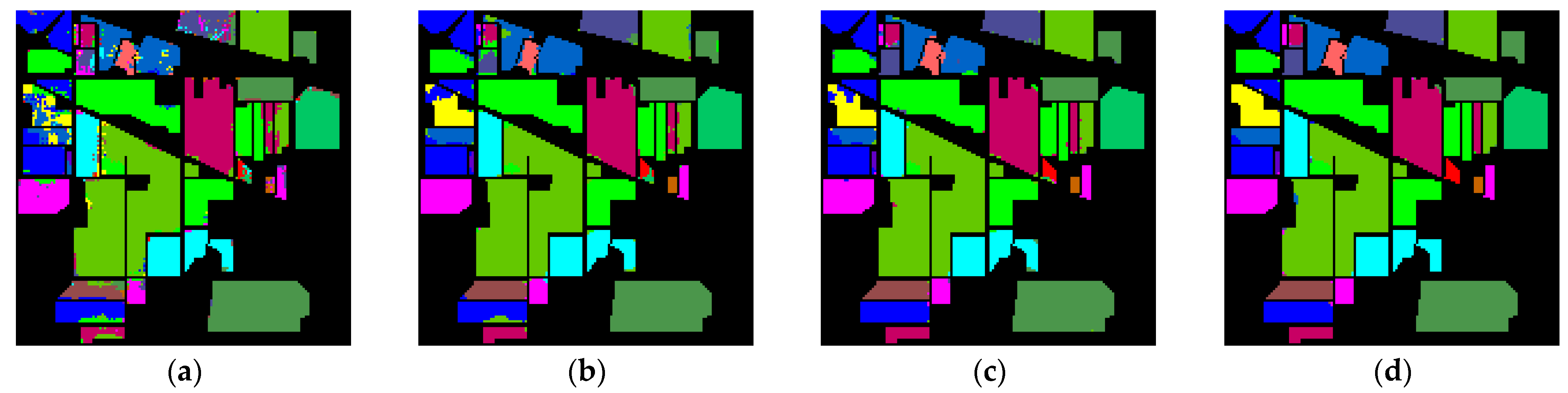
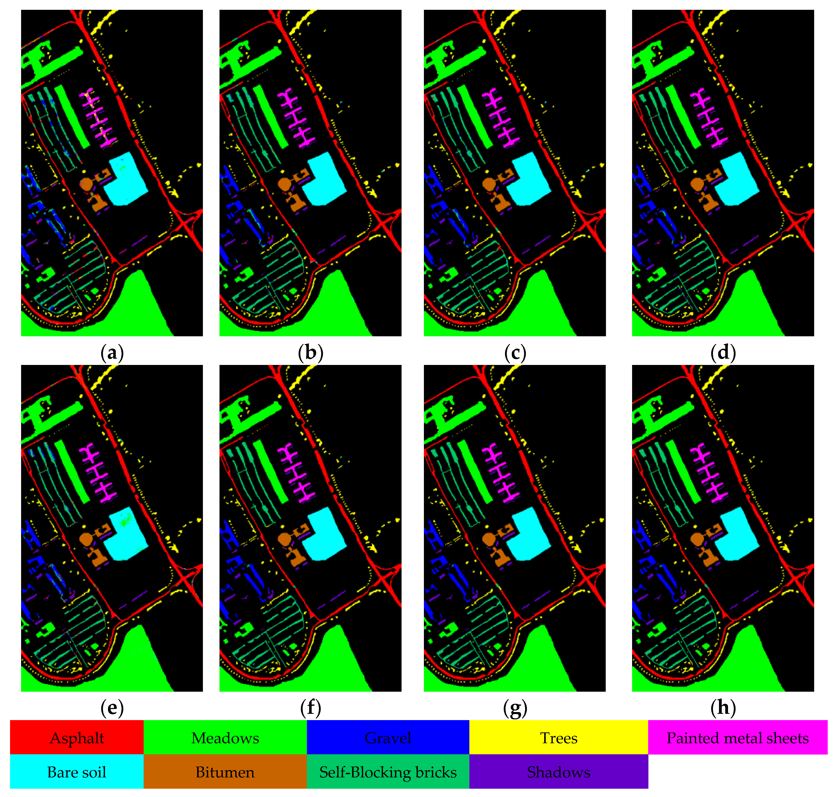
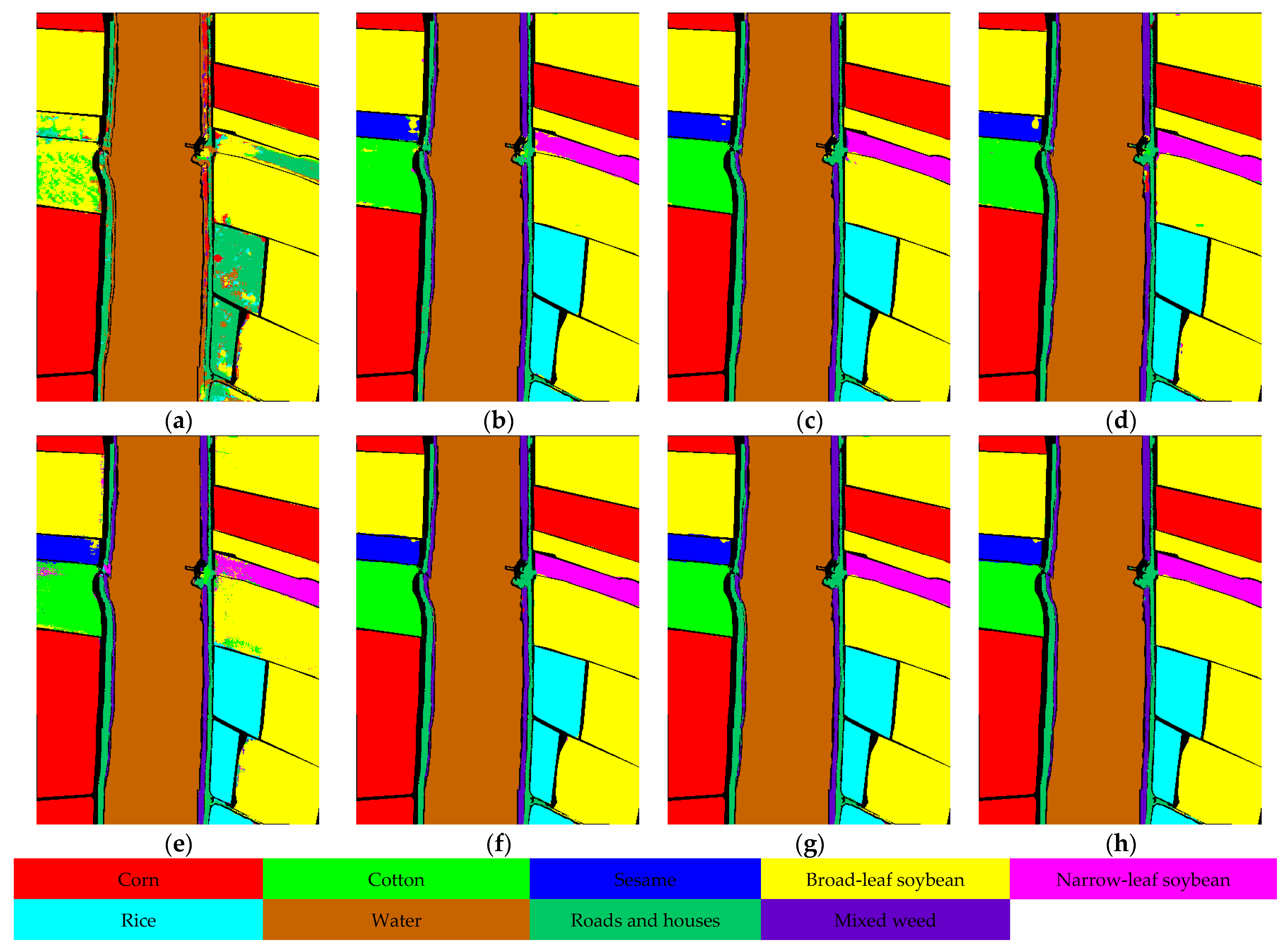
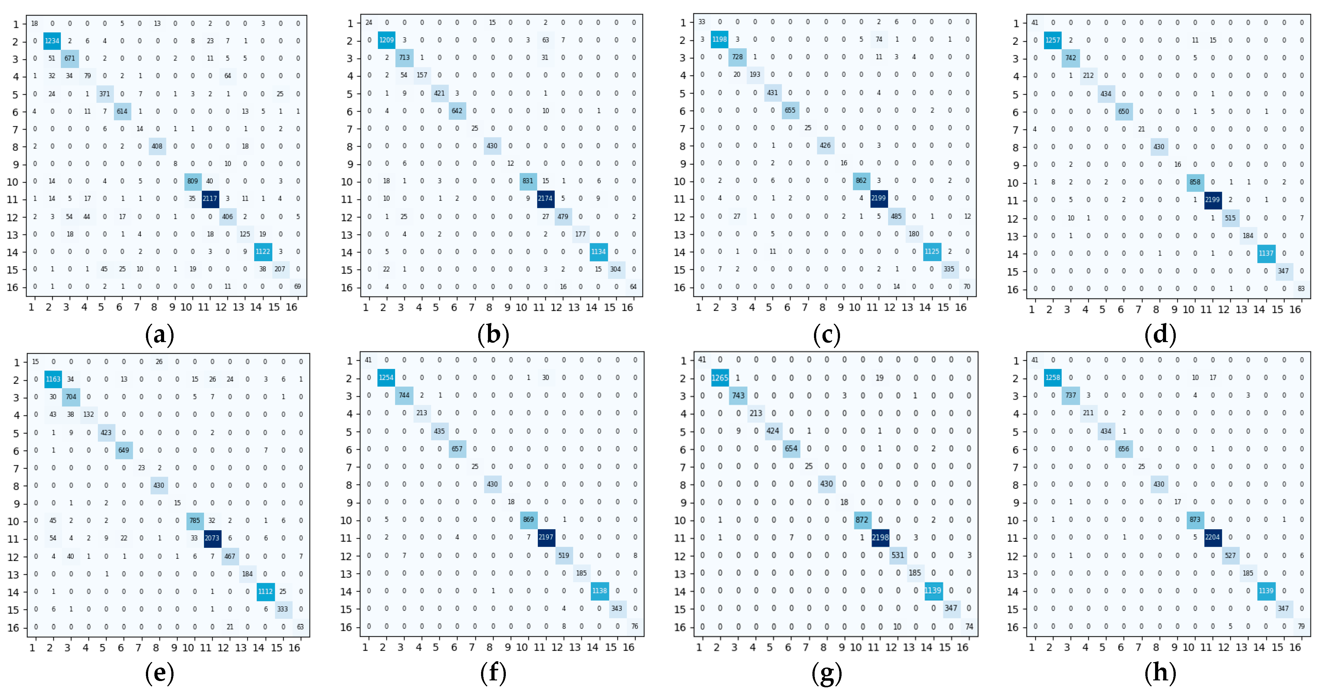
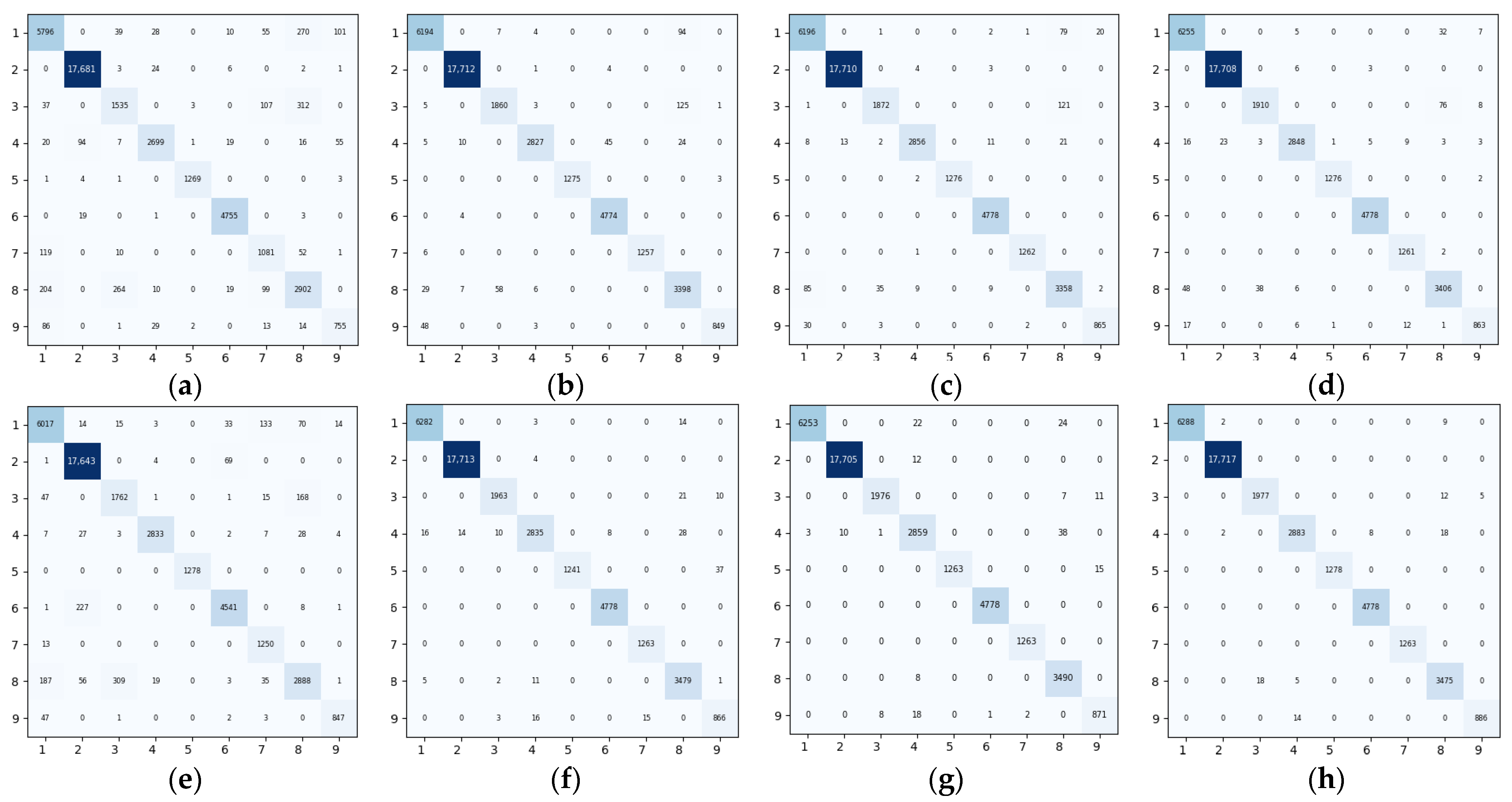
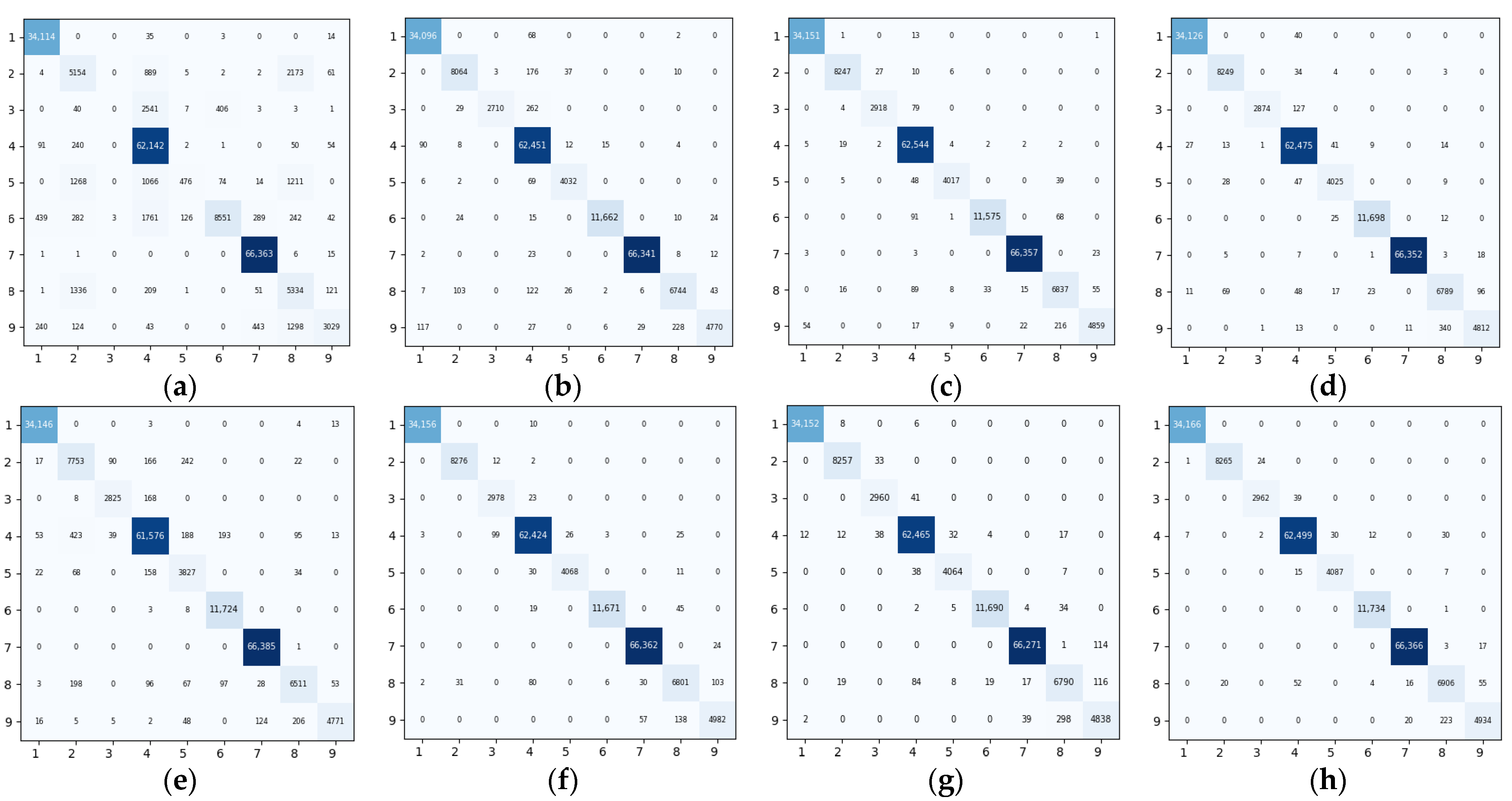
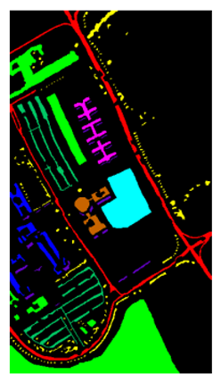
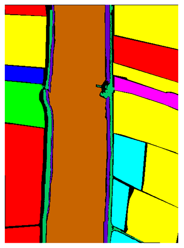
4.1. Data Description
- (1)
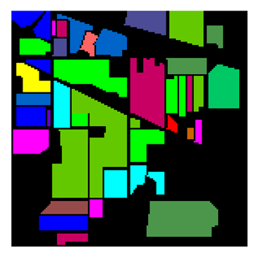
- The first dataset is India Pines, which was captured by the documented sensor AVIRS at the Agricultural Experiment Range in northwestern Indiana, USA. The spatial resolution of the image is , and the effective spectral bands after removal of interfering bands (e.g., low signal-to-noise ratio and water vapor absorption bands) is 200. The area is mainly covered with agricultural and natural vegetation with 16 feature classes. During the experiment, 10% of the samples from each category were randomly selected for training and the remaining samples were used as the test set. The detailed division information of the dataset of this HSI is shown in Table 1.
- (2)
- The second dataset is Pavia University, which was acquired by the Reflectance Optical System Imaging Spectrometer (ROSIS) over the University of Pavia, Italy. The spatial resolution of the image is and there are 103 effective spectral bands with a total of nine feature classes. During the experiments, 5% of the samples from each class were randomly selected for training and the remaining samples were used as a test set. The detailed division information of the dataset of this HSI is shown in Table 2.
- (3)
- The third dataset is the WHU-Hi-LongKou dataset, which was collected by the RSIDEA group of Wuhan University in July 2018 in Longkou Town, Hubei Province, China, using an 8 mm focal-length headwall nano-hyperspectral imaging sensor mounted on a DJI Matrice 600 Pro (DJI M600 Pro) drone platform. The study area was a simple agricultural scene with nine feature classes. The UAV was flown at an altitude of 500 m and the resolution of the images was with a total of 270 spectral bands. During the experiment, 1% of the samples of each category were randomly selected for training, and the remaining samples were used as the test set. The detailed division information of the dataset of this HSI is shown in Table 3.
4.2. Parameter Setting
4.3. Performance Comparison
5. Discussion
6. Conclusions
Author Contributions
Funding
Data Availability Statement
Conflicts of Interest
References
- Mahlein, A.-K.; Oerke, E.-C.; Steiner, U.; Dehne, H.-W. Recent advances in sensing plant diseases for precision crop protection. Eur. J. Plant Pathol. 2012, 133, 197–209. [Google Scholar] [CrossRef]
- Su, H.; Yao, W.; Wu, Z.; Zheng, P.; Du, Q. Kernel low-rank representation with elastic net for China coastal wetland land cover classification using GF-5 hyperspectral imagery. ISPRS J. Photogramm. Remote Sens. 2021, 171, 238–252. [Google Scholar] [CrossRef]
- Bioucas-Dias, J.M.; Plaza, A.; Camps-Valls, G.; Scheunders, P.; Nasrabadi, N.; Chanussot, J. Hyperspectral Remote Sensing Data Analysis and Future Challenges. IEEE Geosci. Remote Sens. Mag. 2013, 1, 6–36. [Google Scholar] [CrossRef]
- Han, Y.; Li, J.; Zhang, Y.; Hong, Z.; Wang, J. Sea Ice Detection Based on an Improved Similarity Measurement Method Using Hyperspectral Data. Sensors 2017, 17, 1124. [Google Scholar] [CrossRef] [PubMed]
- Li, J.; Khodadadzadeh, M.; Plaza, A.; Jia, X.; Bioucas-Dias, J.M. A discontinuity preserving relaxation scheme for spectral–spatial hyperspectral image classification. IEEE J. Sel. Top. Appl. Earth Observ. Remote Sens. 2015, 9, 625–663. [Google Scholar] [CrossRef]
- Melgani, F.; Bruzzone, L. Classification of hyperspectral remote sensing images with support vector machines. IEEE Trans. Geosci. Remote Sens. 2004, 42, 1778–1790. [Google Scholar] [CrossRef]
- Ham, J.; Yangchi, C.; Crawford, M.M.; Ghosh, J. Investigation of the random forest framework for classification of hyperspectral data. IEEE Trans. Geosci. Remote Sens. 2005, 43, 492–501. [Google Scholar] [CrossRef]
- Li, J.; Bioucas-Dias, J.M.; Plaza, A. Semisupervised Hyperspectral Image Segmentation Using Multinomial Logistic Regression With Active Learning. IEEE Trans. Geosci. Remote Sens. 2010, 48, 4085–4098. [Google Scholar] [CrossRef]
- Chen, C.; Li, W.; Su, H.; Liu, K. Spectral-Spatial Classification of Hyperspectral Image Based on Kernel Extreme Learning Machine. Remote Sens. 2014, 6, 5795–5814. [Google Scholar] [CrossRef]
- Kettig, R.L.; Landgrebe, D. Classification of multispectral image data by extraction and classification of homogeneous objects. IEEE Trans. Geosci. Electron. 1976, 14, 19–26. [Google Scholar] [CrossRef]
- Cao, X.; Xu, Z.; Meng, D. Spectral-Spatial Hyperspectral Image Classification via Robust Low-Rank Feature Extraction and Markov Random Field. Remote Sens. 2019, 11, 1565. [Google Scholar] [CrossRef]
- Tarabalka, Y.; Fauvel, M.; Chanussot, J.; Benediktsson, J.A. SVM- and MRF-Based Method for Accurate Classification of Hyperspectral Images. IEEE Geosci. Remote Sens. Lett. 2010, 7, 736–740. [Google Scholar] [CrossRef]
- Li, W.; Prasad, S.; Fowler, J.E. Hyperspectral Image Classification Using Gaussian Mixture Models and Markov Random Fields. IEEE Geosci. Remote Sens. Lett. 2014, 11, 153–157. [Google Scholar] [CrossRef]
- Liu, J.; Wu, Z.; Xiao, Z.; Yang, J. Classification of Hyperspectral Images Using Kernel Fully Constrained Least Squares. ISPRS Int. J. Geo-Inf. 2017, 6, 344. [Google Scholar] [CrossRef]
- Liu, J.; Xiao, Z.; Chen, Y.; Yang, J. Spatial-Spectral Graph Regularized Kernel Sparse Representation for Hyperspectral Image Classification. ISPRS Int. J. Geo-Inf. 2017, 6, 258. [Google Scholar] [CrossRef]
- Li, J. Active learning for hyperspectral image classification with a stacked autoencoders based neural network. In Proceedings of the 2015 7th Workshop on Hyperspectral Image and Signal Processing: Evolution in Remote Sensing (WHISPERS), Tokyo, Japan, 2–5 June 2015. [Google Scholar]
- Ma, X.; Wang, H.; Geng, J. Spectral–Spatial Classification of Hyperspectral Image Based on Deep Auto-Encoder. IEEE J. Sel. Top. Appl. Earth Observ. Remote Sens. 2016, 9, 4073–4085. [Google Scholar] [CrossRef]
- Chao, T.; Hongbo, P.; Yansheng, L.; Zhengrou, Z. Unsupervised Spectral–Spatial Feature Learning With Stacked Sparse Autoencoder for Hyperspectral Imagery Classification. IEEE Geosci. Remote Sens. Lett. 2015, 12, 2438–2442. [Google Scholar] [CrossRef]
- Le, J.H.; Yazdanpanah, A.P.; Regentova, E.E.; Muthukumar, V. A deep belief network for classifying remotely-sensed hyperspectral data. In Proceedings of the Advances in Visual Computing: 11th International Symposium (ISVC), Las Vegas, NV, USA, 14–16 December 2015. [Google Scholar]
- Guofeng, T.; Yong, L.; Lihao, C.; Chen, J. A DBN for hyperspectral remote sensing image classification. In Proceedings of the 2017 12th IEEE Conference on Industrial Electronics and Applications (ICIEA), Siem Reap, Cambodia, 18–20 June 2017. [Google Scholar]
- Zhou, X.; Li, S.; Tang, F.; Qin, K.; Hu, S.; Liu, S. Deep Learning With Grouped Features for Spatial Spectral Classification of Hyperspectral Images. IEEE Geosci. Remote Sens. Lett. 2017, 14, 97–101. [Google Scholar] [CrossRef]
- Gao, H.; Yang, Y.; Li, C.; Zhou, H.; Qu, X. Joint Alternate Small Convolution and Feature Reuse for Hyperspectral Image Classification. ISPRS Int. J. Geo-Inf. 2018, 7, 349. [Google Scholar] [CrossRef]
- Li, M.; Lu, Y.; Cao, S.; Wang, X.; Xie, S. A Hyperspectral Image Classification Method Based on the Nonlocal Attention Mechanism of a Multiscale Convolutional Neural Network. Sensors 2023, 23, 3190. [Google Scholar] [CrossRef]
- Zhao, Z.; Wang, H.; Yu, X. Spectral–Spatial Graph Attention Network for Semisupervised Hyperspectral Image Classification. IEEE Geosci. Remote Sens. Lett. 2022, 19, 1–5. [Google Scholar] [CrossRef]
- Wang, H.; Cheng, Y.; Chen, C.L.P.; Wang, X. Semisupervised Classification of Hyperspectral Image Based on Graph Convolutional Broad Network. IEEE J. Sel. Top. Appl. Earth Observ. Remote Sens. 2021, 14, 2995–3005. [Google Scholar] [CrossRef]
- Li, W.; Wu, G.; Zhang, F.; Du, Q. Hyperspectral Image Classification Using Deep Pixel-Pair Features. IEEE Geosci. Remote Sens. 2017, 55, 844–853. [Google Scholar] [CrossRef]
- Chen, Y.; Jiang, H.; Li, C.; Jia, X.; Ghamisi, P. Deep Feature Extraction and Classification of Hyperspectral Images Based on Convolutional Neural Networks. IEEE Geosci. Remote Sens. 2016, 54, 6232–6251. [Google Scholar] [CrossRef]
- Ben Hamida, A.; Benoit, A.; Lambert, P.; Ben Amar, C. 3-D Deep Learning Approach for Remote Sensing Image Classification. IEEE Trans. Geosci. Remote Sens. 2018, 56, 4420–4434. [Google Scholar] [CrossRef]
- He, M.; Li, B.; Chen, H. Multi-scale 3D deep convolutional neural network for hyperspectral image classification. In Proceedings of the 2017 IEEE International Conference on Image Processing (ICIP), Beijing, China, 17–20 September 2017. [Google Scholar]
- Zhong, J.; Li, Z.; Chapman, M. Spectral-Spatial Residual Network for Hyperspectral Image Classification: A 3-D Deep Learning Framework. IEEE Trans. Geosci. Remote Sens. 2018, 2, 847–858. [Google Scholar] [CrossRef]
- Roy, S.K.; Krishna, G.; Dubey, S.R.; Chaudhuri, B.B. HybridSN: Exploring 3-D–2-D CNN Feature Hierarchy for Hyperspectral Image Classification. IEEE Geosci. Remote Sens. Lett. 2020, 17, 277–281. [Google Scholar] [CrossRef]
- Shu, Z.; Liu, Z.; Zhou, J.; Tang, S.; Yu, Z.; Wu, X.-J. Spatial–Spectral Split Attention Residual Network for Hyperspectral Image Classification. IEEE J. Sel. Top. Appl. Earth Observ. Remote Sens. 2023, 16, 419–430. [Google Scholar] [CrossRef]
- Zhao, F.; Li, S.; Zhang, J.; Liu, H. Convolution Transformer Fusion Splicing Network for Hyperspectral Image Classification. IEEE Geosci. Remote Sens. Lett. 2023, 20, 1–5. [Google Scholar] [CrossRef]
- Qin, A.; Shang, Z.; Tian, J.; Wang, Y.; Zhang, T.; Tang, Y.Y. Spectral–Spatial Graph Convolutional Networks for Semisupervised Hyperspectral Image Classification. IEEE Geosci. Remote Sens. Lett. 2019, 16, 241–245. [Google Scholar] [CrossRef]
- Ding, Y.; Zhang, Z.-L.; Zhao, X.-F.; Cai, W.; He, F.; Cai, Y.-M.; Cai, W.-W. Deep hybrid: Multi-graph neural network collaboration for hyperspectral image classification. Def. Technol. 2023, 23, 164–176. [Google Scholar]
- Ding, Y.; Zhao, X.; Zhang, Z.; Cai, W.; Yang, N. Graph sample and aggregate-attention network for hyperspectral image classification. IEEE Geosci. Remote Sens. Lett. 2021, 19, 1–5. [Google Scholar] [CrossRef]
- Liu, Q.; Xiao, L.; Yang, J.; Wei, Z. CNN-Enhanced Graph Convolutional Network with Pixel- and Superpixel-Level Feature Fusion for Hyperspectral Image Classification. IEEE Geosci. Remote Sen. 2021, 59, 8657–8671. [Google Scholar] [CrossRef]
- Sha, A.; Wang, B.; Wu, X.; Zhang, L. Semisupervised Classification for Hyperspectral Images Using Graph Attention Networks. IEEE Geosci. Remote Sens. Lett. 2021, 18, 157–161. [Google Scholar] [CrossRef]
- Achanta, R.; Shaji, A.; Smith, K.; Lucchi, A.; Fua, P.; Süsstrunk, S. SLIC Superpixels Compared to State-of-the-Art Superpixel Methods. IEEE Trans. Pattern Anal. Mach. Intell. 2012, 34, 2274–2282. [Google Scholar] [CrossRef] [PubMed]
- Zhengang, Z.; Dan, H.; Hao, W.; Xianchuan, Y. Convolutional Transformer Network for Hyperspectral Image Classification. IEEE Geosci. Remote Sens. Lett. 2022, 19, 1–5. [Google Scholar]
- Chen, Y.; Fan, H.; Xu, B.; Yan, Z.; Kalantidis, Y.; Rohrbach, M.; Shuicheng, Y.; Feng, J. Drop an Octave: Reducing Spatial Redundancy in Convolutional Neural Networks with Octave Convolution. In Proceedings of the IEEE/CVF International Conference on Computer Vision, Seoul, Republic of Korea, 27 October–2 November 2019. [Google Scholar]
- Feng, Y.; Zheng, J.; Qin, M.; Bai, C.; Zhang, J. 3D Octave and 2D Vanilla Mixed Convolutional Neural Network for Hyperspectral Image Classification with Limited Samples. Remote Sens. 2021, 13, 4407. [Google Scholar] [CrossRef]
- Lian, L.; Jun, L.; Zhang, S. Hyperspectral Image Classification Method based on 3D Octave Convolution and Bi-RNN Ateention Network. Acta Photonica Sin. 2021, 50, 0910001. [Google Scholar]
- Shi, C.; Sun, J.; Wang, T.; Wang, L. Hyperspectral Image Classification Based on a 3D Octave Convolution and 3D Multiscale Spatial Attention Network. Remote Sens. 2023, 15, 257. [Google Scholar] [CrossRef]
- Howard, A.G.; Zhu, M.; Chen, B.; Kalenichenko, D.; Wang, W.; Weyand, T.; Andreetto, M.; Adam, H. Mobilenets: Efficient convolutional neural networks for mobile vision applications. arXiv 2017, arXiv:1704.04861. [Google Scholar]
- Zhong, Y.; Hu, X.; Luo, C.; Wang, X.; Zhao, J.; Zhang, L. WHU-Hi: UAV-borne hyperspectral with high spatial resolution (H2) benchmark datasets and classifier for precise crop identification based on deep convolutional neural network with CRF. Remote Sens. Environ. 2020, 250, 112012. [Google Scholar] [CrossRef]
- Zhong, Y.; Wang, X.; Xu, Y.; Wang, S.; Jia, T.; Hu, X.; Zhao, J.; Wei, L.; Zhang, L. Mini-UAV-Borne Hyperspectral Remote Sensing: From Observation and Processing to Applications. IEEE Geosci. Remote Sens. Mag. 2018, 6, 46–62. [Google Scholar] [CrossRef]
- Hong, Q.; Zhong, X.; Chen, W.; Zhang, Z.; Li, B.; Sun, H.; Yang, T.; Tan, C. SATNet: A Spatial Attention Based Network for Hyperspectral Image Classification. Remote Sens. 2022, 14, 5902. [Google Scholar] [CrossRef]
- Dosovitskiy, A.; Beyer, L.; Kolesnikov, A.; Weissenborn, D.; Zhai, X.; Unterthiner, T.; Dehghani, M.; Minderer, M.; Heigold, G.; Gelly, S.; et al. An Image Is Worth 16×16 Words: Transformers for Image Recognition at Scale. arXiv 2020, arXiv:2010.11929. [Google Scholar]
- Sun, L.; Zhao, G.; Zheng, Y.; Wu, Z. Spectral–spatial feature tokenization transformer for hyperspectral image classification. IEEE Geosci. Remote Sens. 2022, 60, 1–14. [Google Scholar] [CrossRef]
- Li, W.; Chen, C.; Su, H.; Du, Q. Local Binary Patterns and Extreme Learning Machine for Hyperspectral Imagery Classification. IEEE Trans. Geosci. Remote Sens. 2015, 53, 3681–3693. [Google Scholar] [CrossRef]
- Ji, S.; Xu, W.; Yang, M.; Yu, K. 3D convolutional neural networks for human action recognition. IEEE Trans. Pattern Anal. Mach. Intell. 2012, 35, 221–231. [Google Scholar] [CrossRef]


| Ground Truth Map | Class Name | Train | Test | Total |
|---|---|---|---|---|
 | Alfalfa | 5 | 41 | 46 |
| Corn-notill | 143 | 1285 | 1428 | |
| Corn-min | 83 | 747 | 830 | |
| Corn | 24 | 213 | 237 | |
| Grass-pasture | 48 | 435 | 483 | |
| Grass-trees | 73 | 657 | 730 | |
| Grass-pasture-mowed | 3 | 25 | 28 | |
| Hay-windrowed | 48 | 430 | 478 | |
| Oats | 2 | 18 | 20 | |
| Soybean-notill | 97 | 875 | 972 | |
| Soybean-mintill | 245 | 2210 | 2455 | |
| Soybean-clean | 59 | 534 | 593 | |
| Wheat | 20 | 185 | 205 | |
| Woods | 126 | 1139 | 1265 | |
| Buildings-Grass-Trees | 39 | 347 | 386 | |
| Stone-Steel-Tosers | 9 | 84 | 93 | |
| Total Samples | 1024 | 9225 | 10,249 | |
| Ground Truth Map | Class Name | Train | Test | Total |
|---|---|---|---|---|
 | Asphalt | 332 | 6299 | 6631 |
| Meadows | 932 | 17,717 | 18,649 | |
| Gravel | 105 | 1994 | 2099 | |
| Trees | 153 | 2911 | 3064 | |
| Painted metal sheets | 67 | 1278 | 1345 | |
| Bare soil | 251 | 4778 | 5029 | |
| Bitumen | 67 | 1263 | 1330 | |
| Self-Blocking bricks | 184 | 3498 | 3682 | |
| Shadows | 47 | 900 | 947 | |
| Total Samples | 2138 | 40,638 | 42,776 | |
| Ground Truth Map | Class Name | Train | Test | Total |
|---|---|---|---|---|
 | Corn | 345 | 34,166 | 34,511 |
| Cotton | 84 | 8290 | 8374 | |
| Sesame | 30 | 3001 | 3031 | |
| Broad-leaf soybean | 632 | 62,580 | 63,212 | |
| Narrow-leaf soybean | 42 | 4109 | 4151 | |
| Rice | 118 | 11,736 | 11,854 | |
| Water | 671 | 66,385 | 67,056 | |
| Roads and houses | 71 | 7053 | 7124 | |
| Mixed weed | 52 | 5177 | 5229 | |
| Total Samples | 2045 | 202,497 | 204,542 | |
| Dataset | Principal Component | Batch Size | Dropout | Learning Rate | Epoch |
|---|---|---|---|---|---|
| IP | 110 | 64 | 0.5 | 0.001 | 100 |
| UP | 30 | 64 | 0.5 | 0.0005 | 100 |
| LK | 30 | 64 | 0.5 | 0.0005 | 100 |
| Class Name | 2DCNN | 3DCNN | M3D-DCNN | HybridSN | Vit | SATNet | SSFTT | OMDSC |
|---|---|---|---|---|---|---|---|---|
| Alfalfa | 16.28 | 0 | 4.03 | 4.7 | 2.24 | 0 | 0 | 0 |
| Corn-notill | 8.69 | 2.9 | 1.2 | 0.51 | 1.19 | 0.24 | 0.31 | 0.35 |
| Corn-min | 8.09 | 1.30 | 1.64 | 0.64 | 1.53 | 0.3 | 0.47 | 0.46 |
| Corn | 20.09 | 0.3 | 1.42 | 0.63 | 5.07 | 0.5 | 1.5 | 0.63 |
| Grass-pasture | 3.77 | 1.12 | 1.62 | 0.78 | 1.35 | 0.3 | 0.70 | 0.51 |
| Grass-trees | 2.53 | 0.64 | 0.63 | 0.22 | 1.62 | 0.22 | 0.61 | 0.41 |
| Grass-pasture-mowed | 21.86 | 0 | 1.54 | 0.15 | 0 | 0 | 1.89 | 1.54 |
| Hay-windrowed | 5.70 | 2.53 | 0.38 | 0.11 | 1.34 | 0.17 | 0 | 0 |
| Oats | 24.12 | 0 | 9.88 | 0 | 89.74 10.6 | 0 | 5.72 | 0 |
| Soybean-notill | 10.46 | 1.6 | 1.66 | 0.76 | 1.15 | 0.38 | 0.58 | 0.61 |
| Soybean-mintill | 5.46 | 1.58 | 0.83 | 0.15 | 2.18 | 0.15 | 0.21 | 0.42 |
| Soybean-clean | 6.52 | 1.24 | 0.87 | 0.39 | 89.27 1.3 | 0.36 | 0.94 | 0.52 |
| Wheat | 9.19 | 0 | 0.84 | 0.58 | 96.82 2.6 | 0 | 0.79 | 1.03 |
| Woods | 1.48 | 1.99 | 1.46 | 0.73 | 97.53 0.9 | 0 | 0.17 | 0.24 |
| Buildings-Grass-Trees | 9.97 | 0.6 | 2.1 | 1.23 | 2.97 | 0.11 | 0.30 | 0.46 |
| Stone-Steel-Tosers | 1.84 | 1.63 | 5.55 | 1.43 | 3.97 | 1.11 | 3.39 | 5.58 |
| OA (%) | 3.56 | 1.09 | 0.08 | 0.12 | 0.51 | 0.05 | 0.12 | 0.14 |
| AA (%) | 4.50 | 4.97 | 0.40 | 1.17 | 1.32 | 0.26 | 0.38 | 0.28 |
| Kappa (%) | 4.09 | 1.26 | 0.09 | 0.14 | 0.58 | 0.06 | 0.14 | 0.16 |
| Class Name | 2DCNN | 3DCNN | M3D-DCNN | HybridSN | Vit | SATNet | SSFTT | OMDSC |
|---|---|---|---|---|---|---|---|---|
| Asphalt | 5.85 | 0.47 | 0.17 | 0.17 | 0.75 | 0.06 | 0.11 | 0.001 |
| Meadows | 7.04 | 0.22 | 0.08 | 0.04 | 0.42 | 0.2 | 0.06 | 0 |
| Gravel | 7.61 | 1.33 | 1.55 | 0.39 | 84.25 2.52 | 0.21 | 0.27 | 0.003 |
| Trees | 6.27 | 0.41 | 0.64 | 0.53 | 0.20 | 0.42 | 0.30 | 0.002 |
| Painted metal sheets | 4.78 | 0 | 0.06 | 0.13 | 0 | 0.03 | 0.06 | 0.002 |
| Bare soil | 1.19 | 0.13 | 0.08 | 0.11 | 0.63 | 0.05 | 0.03 | 0 |
| Bitumen | 5.55 | 0.27 | 0.28 | 0.49 | 2.78 | 0.18 | 0.13 | 0.002 |
| Self-Blocking bricks | 6.36 | 0.89 | 0.59 | 0.95 | 1.69 | 0.09 | 0.58 | 0.004 |
| Shadows | 11.29 | 0.85 | 2.13 | 0.75 | 1.06 | 0.55 | 0.40 | 0.002 |
| OA (%) | 2.22 | 0.31 | 0.16 | 0.05 | 0.35 | 0.01 | 0.08 | 0.05 |
| AA (%) | 5.0 | 5.42 | 0.24 | 0.14 | 0.45 | 0.02 | 0.11 | 0.1 |
| Kappa (%) | 2.95 | 0.42 | 0.21 | 0.06 | 0.46 | 0.01 | 0.10 | 0.06 |
| Class Name | 2DCNN | 3DCNN | M3D-DCNN | HybridSN | Vit | SATNet | SSFTT | OMDSC |
|---|---|---|---|---|---|---|---|---|
| Corn | 4.12 | 0.17 | 0.03 | 0.14 | 0.002 | 0.03 | 0.04 | 0 |
| Cotton | 10.42 | 0.44 | 0.26 | 0.22 | 0.007 | 0.03 | 0.15 | 0.2 |
| Sesame | 7.61 | 0.26 | 0.37 | 0.38 | 0.008 | 0.03 | 0.64 | 0.59 |
| Broad-leaf soybean | 5.11 | 0.32 | 0.06 | 0.18 | 0.002 | 0.02 | 0.05 | 0.06 |
| Narrow-leaf soybean | 31.1 | 0.66 | 0.92 | 0.74 | 0.021 | 0.56 | 0.31 | 0.29 |
| Rice | 14.56 | 0.23 | 0.07 | 0.12 | 0.002 | 0.02 | 0.08 | 0.10 |
| Water | 2.98 | 0.04 | 0.04 | 0.02 | 0 | 0.02 | 0.10 | 0.05 |
| Roads and houses | 14.93 | 0.96 | 0.39 | 1.03 | 0.008 | 0.10 | 0.50 | 0.64 |
| Mixed weed | 18.38 | 0.25 | 0.77 | 0.67 | 0.004 | 0.25 | 0.83 | 0.42 |
| OA (%) | 2.50 | 0.16 | 0.04 | 0.60 | 0.065 | 0.02 | 0.16 | 0.01 |
| AA (%) | 6.86 | 0.38 | 0.13 | 0.21 | 0.434 | 0.05 | 0.13 | 0.05 |
| Kappa (%) | 3.48 | 0.05 | 0.08 | 0.086 | 0.03 | 0.02 | 0.01 |
| Dataset | Network | OA (%) | AA (%) | Kappa (%) |
|---|---|---|---|---|
| IP | OctNet | 97.43 0.46 | 83.31 4.42 | 97.06 0.53 |
| DscNet | 97.80 0.71 | 87.98 5.58 | 97.49 0.81 | |
| OMDSC | 99.13 0.14 | 98.66 0.28 | 99.00 0.16 | |
| UP | OctNet | 99.45 0.09 | 99.03 0.13 | 99.26 0.12 |
| DscNet | 99.54 0.10 | 99.15 0.16 | 99.39 0.13 | |
| OMDSC | 99.68 0.05 | 99.38 0.1 | 99.58 0.06 | |
| LK | OctNet | 99.51 0.02 | 98.18 0.17 | 99.36 0.36 |
| DscNet | 99.43 0.06 | 97.95 0.11 | 99.26 0.08 | |
| OMDSC | 99.69 0.01 | 98.95 0.05 | 99.60 0.01 |
Disclaimer/Publisher’s Note: The statements, opinions and data contained in all publications are solely those of the individual author(s) and contributor(s) and not of MDPI and/or the editor(s). MDPI and/or the editor(s) disclaim responsibility for any injury to people or property resulting from any ideas, methods, instructions or products referred to in the content. |
© 2023 by the authors. Licensee MDPI, Basel, Switzerland. This article is an open access article distributed under the terms and conditions of the Creative Commons Attribution (CC BY) license (https://creativecommons.org/licenses/by/4.0/).
Share and Cite
Hong, Q.; Zhong, X.; Chen, W.; Zhang, Z.; Li, B. Hyperspectral Image Classification Network Based on 3D Octave Convolution and Multiscale Depthwise Separable Convolution. ISPRS Int. J. Geo-Inf. 2023, 12, 505. https://doi.org/10.3390/ijgi12120505
Hong Q, Zhong X, Chen W, Zhang Z, Li B. Hyperspectral Image Classification Network Based on 3D Octave Convolution and Multiscale Depthwise Separable Convolution. ISPRS International Journal of Geo-Information. 2023; 12(12):505. https://doi.org/10.3390/ijgi12120505
Chicago/Turabian StyleHong, Qingqing, Xinyi Zhong, Weitong Chen, Zhenghua Zhang, and Bin Li. 2023. "Hyperspectral Image Classification Network Based on 3D Octave Convolution and Multiscale Depthwise Separable Convolution" ISPRS International Journal of Geo-Information 12, no. 12: 505. https://doi.org/10.3390/ijgi12120505
APA StyleHong, Q., Zhong, X., Chen, W., Zhang, Z., & Li, B. (2023). Hyperspectral Image Classification Network Based on 3D Octave Convolution and Multiscale Depthwise Separable Convolution. ISPRS International Journal of Geo-Information, 12(12), 505. https://doi.org/10.3390/ijgi12120505