Article

Evaluation of Urban Flood Resilience Enhancement Strategies—A Case Study in Jingdezhen City under 20-Year Return Period Precipitation Scenario

1
State Key Laboratory of Hydrology-Water Resources and Hydraulic Engineering, Hohai University, Nanjing 210098, China
2
Research Institute of Management Science, Hohai University, Nanjing 211100, China
*
Author to whom correspondence should be addressed.
ISPRS Int. J. Geo-Inf. 2022, 11(5), 285; https://doi.org/10.3390/ijgi11050285
Submission received: 4 March 2022 / Revised: 12 April 2022 / Accepted: 26 April 2022 / Published: 28 April 2022
(This article belongs to the Topic Advanced Research in Precipitation Measurements)

Abstract

:
Various flood resilience enhancement measures have been proposed to deal with the growing problem of urban flooding. However, there is a lack of evaluation about the applicability of these measures at a community scale. This paper investigates the effects of two types of flood resilience enhancement measures: engineering measures and adaptive measures, in order to explore their effectiveness in different flood-prone communities. A community-scale oriented flood resilience assessment method is used to assess the impact of different types of measures. A case study is applied in three communities that suffer from waterlogging problems in Jingdezhen city, China. Results show that there are spatial differences of flood resilience in three flood-prone communities. Future scenarios present a poorer performance in flood resilience compared to current scenarios due to the effects of urbanization and human activities. Engineering measures are suitable for the old communities with high-density residential areas when sitting alongside the river, for example the communities of Fuliang and Zhushan. On the other hand, adaptive measures exhibit more efficiency in improving flood resilience in all communities, especially effective for the new city town Changjiang where engineering measures are nearly saturated. The findings can help local governments develop appropriate flood resilience enhancement strategies for different types of communities.

1. Introduction

In the background of climate change and rapid urbanization, the changes of the human lifestyle and production has influenced rainfall, runoff, and other hydrological processes [1], which has manifested the frequent occurrence of extreme rainstorms and the escalation of urban floods in urbanized areas. It has been highlighted that climate change imposes a non-linear nature of impacts on streamflow and floodplain inundation, thus affecting water resources and the frequency of floods in different basins around the world [2,3,4]. The total direct flood losses in high urbanized cities in China have reached 42 billion USD in the year 2020 according to the statistical data of Chinese Flood and Drought Disaster Bulletin [5], which reveals the fact that cities are facing great challenges in urban flood control and prevention. As the current situation of population growth and urbanization continues, it is expected that more of the population will be exposed to risk as well as aggregated assets. Nowadays, more than half of the world population are living in urban areas, and this number is expected to reach 75% by the year 2050 [6,7]. Urban systems are facing an unprecedented crisis that urgently requires a new understanding of urban disaster risk mitigation and control [8].
Resilience as an emerging urban research direction, is essentially a proactive exploration of adjustment methods in response to the uncertain perturbations that modern cities face [9], which can be adequate for acting as an indicator to evaluate the abilities of cities [10]. The concept of resilience was proposed by the ecologist Holling in 1973 [11]. It refers to the ability of a system to absorb external shocks and to quickly recover to the original state to keep the system stable. In recent years, the concept of resilience has shifted from an ecological to a multidimensional perspective [12,13,14,15,16,17,18,19]. Particularly, it has been frequently used in the field of climate change and disaster risk analysis. In early times, Brad Allenby defined resiliency as ‘the capability of a system to maintain its functions and structure in the face of internal and external change and to degrade gracefully’ from the perspective of disaster risk analysis in Science in 2005 [20]. Afterwards, in the popular discussion of climate change in urban areas, resilience is defined as ‘the capacity to withstand a wide array of shocks and stresses [21]’ or ‘to dynamically and effectively respond to shifting climate circumstances while continuing to function at an acceptable level [22]’. Furthermore, the urgent need of cities to help them better prepare for and recover from disasters emerged that resilience in disaster management began to gain attention from researchers [23].
Building resilience in cities is considered as an effective measure for dealing with urban disaster issues [24]. In 2009, a framework for building a disaster-risk-reduced resilient city in response to climate change was proposed by the Institute of Global Environment in Kyoto University, Japan [25]; The Bonn ‘Resilient City’ conference series were held in 2010 to discuss climate resilience chapters; and the UNISDR has been organizing and implementing the Make Cities Resilient Campaign since 2012. The United Nations International Disaster Reduction Agency (UNISDR) proposed a research framework on disaster risk reduction to build urban disaster resilience in 2014. With these proposals and guidelines of building resilience, practices have been put forward to enhance urban resilience. For example, the Netherlands’ Rotterdam Climate Adaptation Strategy [26] enhances urban resilience by building green infrastructure, water plazas, and other more resilient infrastructures. The New York Adaptation Plan [27] was developed after the hurricane sweep, with two types of measures, infrastructure and urban reconstruction, as entry points to enhance the city’s ability to cope with future climate disaster risks in order to build a resilient city. Japanese scholars proposed a territorial design plan based on improving the quality-of-life level of residents as a post-disaster urban resilience enhancement strategy, which includes measures such as territorial reconstruction, a road opening plan, and village diversions [28]. Indian scholars identified that spatial planning strategies contribute to community resilience to a great extent [29]. Some scholars also pointed out that urban resilience should be improved by enhancing the resilience of important infrastructures and key nodes within cities [30,31,32].
Focusing on urban flood resilience, it is defined as the capacity of the city to tolerate flooding and to recognize when physical damage and socioeconomic disruption occur, so as to prevent deaths and injuries and maintain their current socioeconomic identity [33]. Studies on flood resilience assessment are mainly focused on examining the performance of cities and communities under disaster scenarios [34,35]. Louise Bertilssona [36] created the multi-criteria urban flood resilience assessment framework S-FRESI, that incorporates water depth simulations into the index and calculated the flood resilience of several smaller areas within a community under different scenarios. Chen [37] built a conceptual time-varying urban flood resilience index where the generated resilience results were mainly based on the time-dependent rainfall-inundation simulations. It can be seen that the introduction of the flooding process is useful for studying the performance of the system. In fact, urban flooding can be intervened by different engineering and non-engineering measures before, during, and after rainstorm events. It is meaningful to explore the effects of these measures and to find out how they can influence cities.
The available flood resilience enhancement strategies are proposed based on resilient city frameworks and local flood protection policies by the government. For example, the University of Groningen studied the data from policy makers and local communities to reconstruct the strategy, process, and anticipated outcome of Bangkok’s flood resilience policy [38]. Diponegoro University investigated the documentation of resilience planning policies of Indonesia from national to local-level efforts [39]. The UK and European countries have led the way in proposing more specific strategies for resilience enhancement. The UK Climate Preparedness Plan (UKCIP) [40] proposed two main types of actions to deal with floods: (1) improve the emergency resilience of residents (including raising public awareness of natural disasters and enhancing resilience); and (2) insist on sustainable infrastructure development. The EU 7th Framework Project STAR-FLOOD [41,42,43] investigated strategies for coping with flood risks in 18 vulnerable urban areas in six European countries (Belgium, UK, France, Netherlands, Poland, and Sweden). The project states that resilience enhancement strategies need to be carried out in the following directions: (1) establish adaptive management to help implement defence and mitigation measures that can be adjusted to suit changing circumstances; (2) deliver spatial planning so that consequences are prevented and minimized if floods occur; (3) improve forecasting, warning, and emergency response systems; (4) develop strategies for flood recovery for all residents to motivate them to adopt prevention and mitigation measures; and (5) establish institutional systems that promote learning and innovation.
In summary, the key to improve urban disaster resilience lies in solving the mismatching between the intensification of natural disasters and social acceptance. According to the above literature review, researchers generally propose countermeasures from two major aspects: planning and management, to formulate strategies for disaster resilience enhancement. On one hand, from the perspective of urban planning, plans are made for population and building development, lifeline system construction, disaster prevention, infrastructure construction, community reconstruction, etc. Specific implementation paths are developed by combining the characteristics of cities and communities. On the other hand, from the management perspective, there is a shift to adaptive management, including raising the knowledge and preparedness of natural hazards, improving emergency response capacities, and developing a public awareness of resilience. In other words, building resilient cities cannot only rely on hard engineering measures, but depends on adaptive strategies for disaster response as well [28]. Taking the Great East Japan Earthquake as an example, local residents were too relieved by the huge 10 m high tidal dike built by the government and lacked awareness and preparedness, so it caused a delay in evacuation actions, resulting in deaths. In recent years, some of the latest resilience enhancement guidelines have incorporated adaptive strategies such as public awareness of pre-disaster preparedness and post-disaster emergency responses. For example, The EU STAR-FLOOD Project proposed a flood recovery strategy for all residents to encourage the adoption of prevention and mitigation measures to cope with flooding.
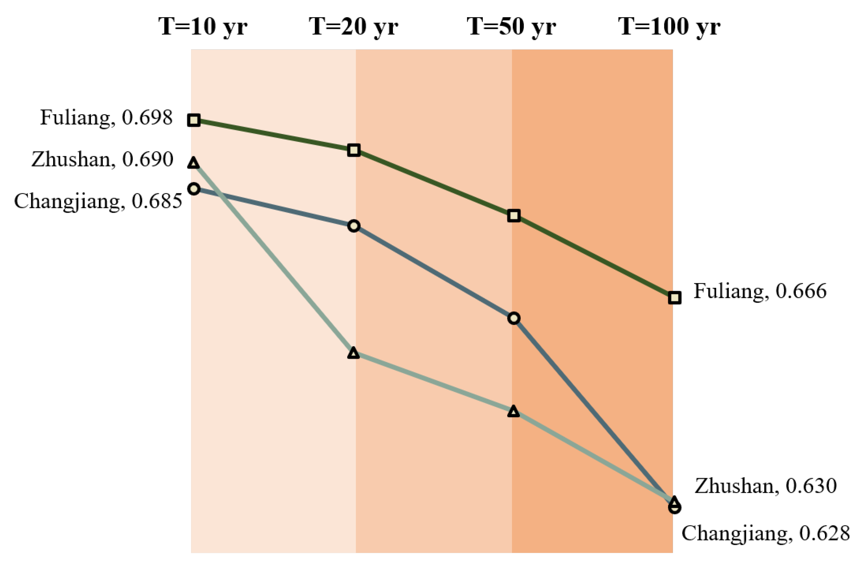
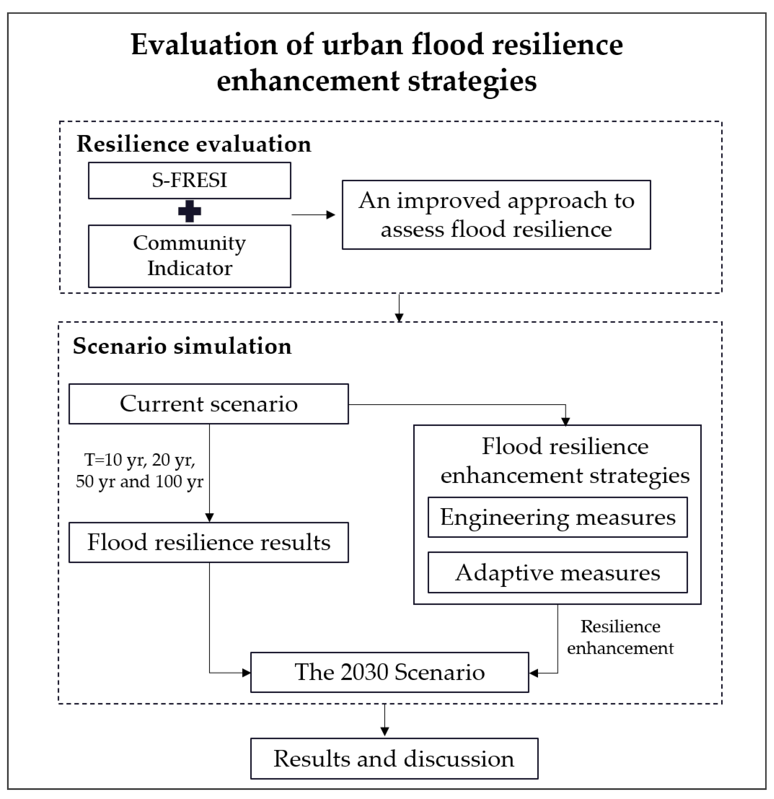
It can be seen that engineering planning and adaptive management are both very important resilience enhancement strategies. But it is not that clear regarding what types of strategies are more effective for resilience enhancement and how different types of measures influence the urban system when floods happen. A comparison between engineering strategies and adaptive strategies is presented in this paper to evaluate their effectiveness and provides evidence for resilience building in the next step. This study examines the applicability and impact of different types of resilience enhancement measures in three typical flood-prone communities. The specific objectives of this study are to (1) compare urban flood resilience in three flood-prone communities between present and future scenarios; (2) investigate the effects of two types of resilience enhancement measures (engineering measures and adaptive measures) of different flood-prone communities in the future scenario; and (3) project specific measures for each individual community according to their features and provide new ideas for flood-prone communities in a resilient way.
The rest of the paper is organized as follows. 
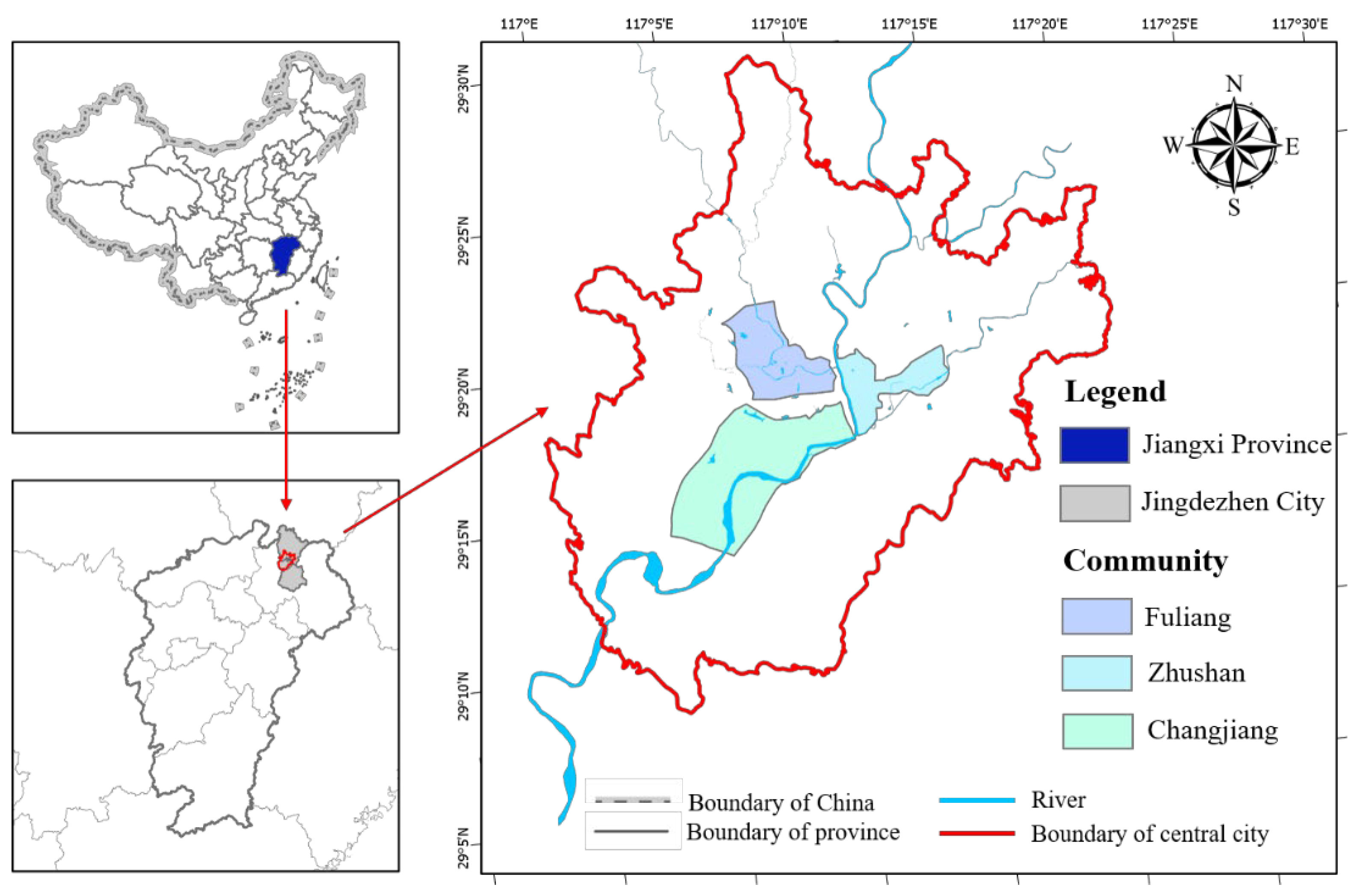
Section 2 introduces the study area of central Jingdezhen city in China and its datasets. In Section 3, two types of flood resilience enhancement measures are introduced and the improved approach to assess flood resilience is explained in detail. In Section 4 and Section 5, the results of flood resilience assessments in three typical flood-prone communities are provided and the impacts of flood resilience enhancement measures in current and future scenarios are discussed. Finally, in Section 6, the conclusion highlights the applicability of flood resilience enhancement strategies and the limitation of the research, as well as the consideration for managerial insight and future work.
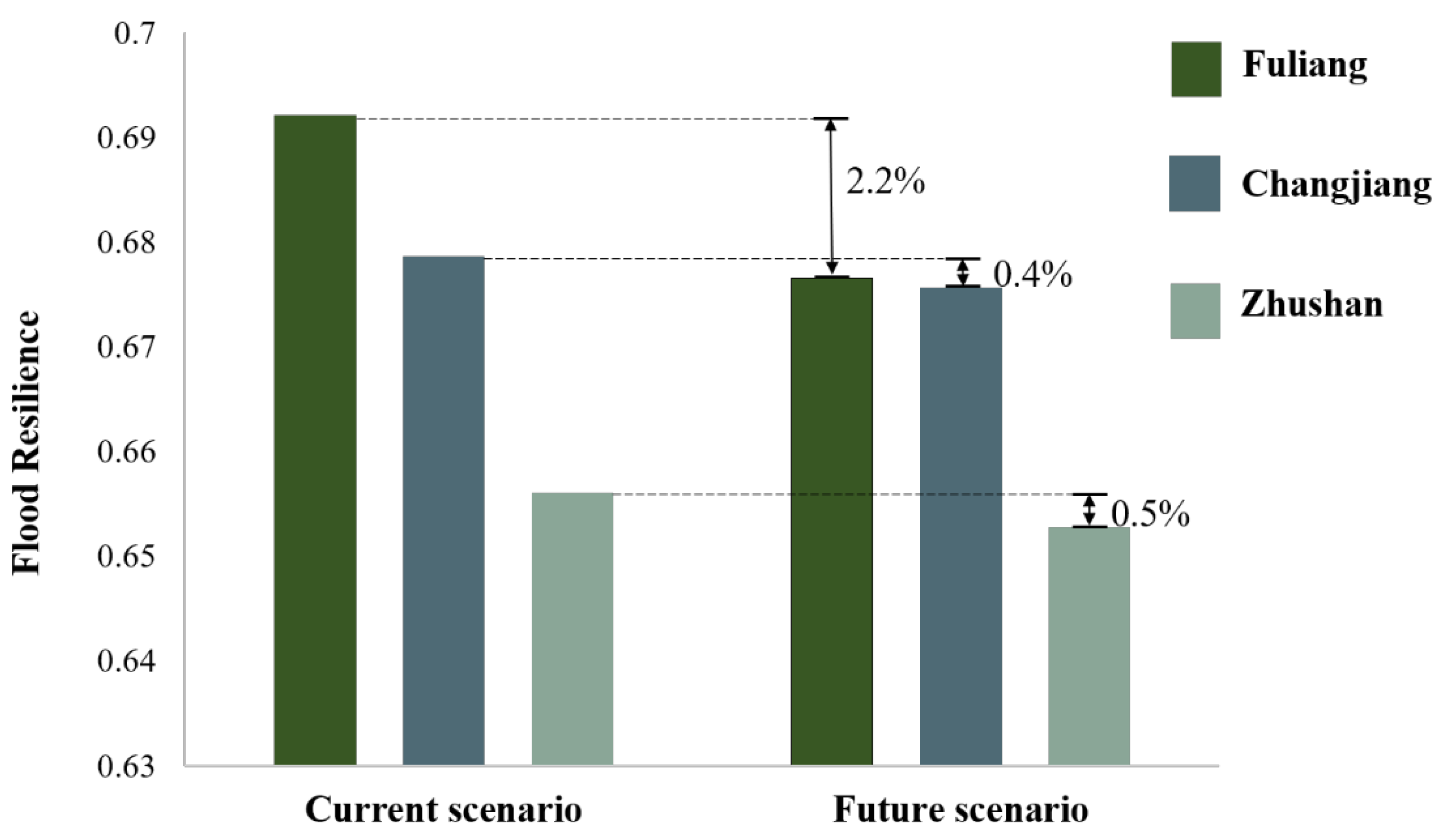
2. Study Area and Data

2.1. Study Area

As a famous historical and cultural city in China, Jingdezhen is most well-known for its ceramic industry. The city has always suffered from urban flooding. In recent years, the city has made many attempts to combat flooding, including the government-led Integrated Flood Management Project at the Wuxikou Reservoir and the World Bank-sponsored Flood Risk Management Project. Thus, it has the theoretical and data basis for the study. Before 2012, Jingdezhen’s urban development lacked a master plan, and the layout of major transportation and other infrastructure had not undergone long-term demonstration. With the rapid development of urbanization in the past 10 years, Jingdezhen City is facing new challenges.
The study area of central Jingdezhen city occupies an area of 720 km2, which is located in the northeast of Jiangxi Province, China (Figure 1). Jingdezhen is characterized by a subtropical monsoon climate, with abundant rainfall and is also one of the three major rainstorm centers in Jiangxi Province. According to Jingdezhen Meteorological Station, the annual average precipitation in the Changjiang River Basin is 1778 mm. There are two main rivers in Jingdezhen, Changjiang River and Le’an River. The central city of Jingdezhen is located on both sides of the Changjiang River and its tributaries, the Nanhe River and the Xihe River. Urban flooding in Jingdezhen city is caused by a combination of seasonal rainstorms and fluvial flooding, with the storm season coinciding with the river flood season. The city is not only located at the center of heavy rainfall but is also threatened by the combined fluvial flooding of the Changjiang River, the Nanhe River, and the Xihe River. The main flooding season is from April to June each year, with short-lasting floods also occurring after July due to typhoons. To cope with urban flooding, the local government has implemented engineering measures such as building embankments and pumping stations, but these engineering projects are not quite adequate for the city. Local residents usually use water-blocking tools such as water barriers, and in severe cases take temporary evacuation measures to reduce damage when flood events occur.
The central area of the city is selected as the study area in this research, with 30.5% as a residential area, 14.3% as communal infrastructure, and 13.1% as green spaces out of the total surface area. Three typical communities Fuliang, Changjiang, and Zhushan in (Figure 1) are selected as prone-flooded communities of central Jingdezhen city according to the past urban flooding statistics: these three communities cover more than 90% of the historical flood-prone areas of central Jingdezhen city; the property damage caused by urban flooding in these three communities is extremely high, with the worst communities experiencing 6.5% of the GDP share of the direct economic loss count caused by the extraordinarily heavy flooding in 2019. Fuliang has an area of 23 km2, with the main stream of the Yangtze River lying across, and covers the most flooded locations in city. Changjiang is located in the new downtown with an area of 53 km2. Zhushan is located in a populated old town with an area of 16 km2. Fuliang is located alongside the South River with an area of 23 km2. Changjiang has an area of 53 km2 with the downstream of the Changjiang River going through and covers the most flooded locations in city. Zhushan is located in a populated old town with an area of 16 km2.

2.2. Data

Flood depth and duration simulation results with the return period of 10 yr, 20 yr, 50 yr, and 100 yr are from hydrological modeling made by MIKE FLOOD [44]. The MIKE software powered by DHI is used for calculation of urban surface floods during a rainstorm event. The MIKE URBAN CS [45] software is used to construct an urban drainage network model to simulate surface runoff and pipe flow in urban catchments and drainage systems. A two-dimensional urban inundation model is built using the hydrodynamic model MIKE 21 [46], which numerically solves the full 2D Saint-Venant equations on a rectangular grid to simulate the flooding process in different topographic conditions, such as roads, neighborhoods, and green spaces. Afterwards, MIKE FLOOD was used for coupling the simultaneous operations of 1-D river flow, 1-D drainage network, and 2-D surface flow to form a three-way coupled urban flooding simulation. The coupled model demonstrates good performance through the implementation of the following steps:
  • Each inspection well of the drainage network model is coupled with the corresponding computational grid of the 2-D surface flow model to reflect the flow interaction between drainage and surface flow.
  • Each outlet in the urban drainage network model is coupled with the corresponding section of river flow to show the interaction between drainage and river flow.
  • The simulation of river flow is coupled with the 2-D surface diffusion model to expose the problem of inland river overflow in cities.
The model is able to simulate the whole process including from the beginning of rainfall to surface discharge, the drainage flow and river flow and the appearance of inundation, as well as the interactions between different flows in these processes. Figure 2 shows the maximum inundation depths of the area under four return periods (100 yr, 50 yr, 20 yr, 5 yr). The maximum inundation depth is classified into 5 levels (0.05–0.5 m, 0.5–1 m, 1–2 m, 2–3 m, and above 3 m), clearly showing the severity of inundation in central city. The most three flood-prone communities Fuliang, Changjiang, and Zhushan in this condition are selected to be analyzed in the next stage as they cover the most inundated areas.
The inputs of precipitation and discharge processes under different return periods were derived from calculations by the Jingdezhen water department. DEM data were downloaded from the SRTM (Shuttle Radar Topography Mission) website with a resolution of 90 m [47]. Demographic and income data were drawn from the statistic yearbook provided from the Jingdezhen government. Industry losses caused by flooding were estimated using the grey model. Land use, household, water project construction, and drainage system conditions were provided by the hydrology department of the Jingdezhen government. Public awareness information was taken from 500 questionnaires given to residents of three flood-prone communities in Jingdezhen city, among which 388 valid copies were taken back.

3. Methods

3.1. Research Framework

The research framework used for evaluating urban flood resilience enhancement strategies is displayed in Figure 3. First, flood resilience of three flood-prone communities were assessed through an improved resilience assessment approach under different precipitation return periods. Then, a comparison between current and future scenarios was carried out to see how resilience would change without any implementation by 2030. The next step was to implement two types of measures and explore their effectiveness in different communities. Finally, the results of evaluation were analyzed and the applicability of two types of measures were discussed.

3.2. Engineering and Adaptive Measures for Flood Resilience Enhancement

In order to explore the impact of different types of measures on urban flood resilience enhancement, this paper proposes two types of urban flood resilience enhancement measures, engineering measures, and adaptive measures, based on the historical flooding inundation situation in Jingdezhen, combined with the geographical characteristics of the city, existing infrastructure, and the level of flood prevention engineering measures applicable to the study area. After meetings and discussions with the local hydrological bureau, the authors’ team proposes the most representative and effective flood control measures for the key inundation areas in conjunction with the ‘Urban Flood Control and Drainage Engineering Plan’ prepared by the local government department, within a reasonable range of engineering practicability and economic, and gives examples below to illustrate how different measures affect the level of urban flood resilience.

3.2.1. Implementation of Engineering Measures

Three engineering measures in the study area of this paper are as follows:
  • Measure 1—Add new pumping stations.
  • Measure 2—Build two new flood storage lakes.
  • Measure 3—A combination of Measure 1 and 2: Add new pumping stations and build two new flood storage lakes.
The three measures are specified below. The central urban area of the study area is located in the confluence section of the Changjiang River and its tributaries, the South and West Rivers, and the terraces along the river are low, which are under greater threat of river flooding. Due to the drainage capacity of the pipe network and the top of the river water level, the low-lying areas in the central city have a greater risk of water accumulation. In the past, the drainage of the urban area was mostly dispersed according to the topography and water system, and only one electric drainage station was built in each of the three pueblos of Xiguanzhou, Lao Cudan, and Sanhe, and the installed scale of the three pumping stations was small, which could only solve the drainage problem of farmland in some areas on the outskirts of the city and far from meeting the requirements of urban flood control and drainage. Therefore, the drainage plan is formulated by dividing the area into 19 drainage areas with the topography, and Measure 1 (as shown in Figure 4) sets up a pumping station along the river in each substandard drainage area and another pumping station in the heart of the city where the city government is located, so that a total of 13 pumping stations are added (the flow rate of pumping stations varies from 2 m3/s to 17 m3/s). At the same time, a pumping station is set up along the North Square Road and South Square Road, where the water in the old city is always serious. Measure 2 proposes to build a new flood storage lake in position A and B, respectively. Location A—Changnan flood storage lake is located in the central city west adjacent to the West River, there is a height difference between the road around this area and the normal water level of the West River. The area was previously farmland and wasteland, and by building a flood storage lake can form an urban park, the lake covers an area of 440,000 m2. Location B—Old South River Flood Storage Lake is on the north side of Dedong Avenue, which was originally farmland and mound, and can meet the needs of both flood storage and landscape greening after completion. This flood storage lake is adjacent to the South River, and the lake body covers 61,000 m2. Measure 3 is the sum of Measure 1 and Measure 2.

3.2.2. Planning Implementation of Adaptive Measures

Japanese scholars [28] believed that the construction of resilient cities cannot rely only on hard engineering measures, but adaptive strategies for disaster management are also crucial. In China, the recent “Beijing Resilient City Planning Outline” emphasizes in resilience enhancement strategies to promote a social co-governance model with diversified participation and to foster resilience awareness among the whole population. Sven Fuchs [48] claimed that in order to cope with flood risk, people usually make risk management plans, but often ignore the public perception of a threat. Gao [49] pointed out that the public’s disaster risk perception is a factor that affects their decision-making behavior in response to disasters, and even directly affects the effectiveness of disaster prevention and mitigation. The public perception of a threat. As mentioned earlier, the study area of Jingdezhen city has its special characteristics that we need to put forward to flood resilience enhancement strategies considering the socio-economic characteristics. After field research and expert interviews, the current situation of flood disaster management systems in the study area can be summarized as follows:
I.
Existing planning is biased towards emergency response for flood control and prevention in cities, counties, and townships, and lacks flood control planning and plans for communities and the public.
II.
Lack of knowledge and initiative of community personnel in flood prevention and mitigation, and insufficient professional level of flood emergency response.
III.
Residents are not really involved in the whole process of flood risk management, and the degree of social participation is not high.
IV.
The public has a fluke mentality about flood risks and does not pay enough attention to flood prevention and mitigation publicity and education, and flood emergency management publicity and education lacks institutionalized guarantee.
Therefore, this paper proposes the following measures as adaptive measures in Table 1 for flood resilience enhancement based on the shortcomings of the current situation of the flood disaster management system in Jingdezhen.

3.3. An Improved Approach to Assess Urban Flood Resilience at a Community Scale

The improved resilience assessment approach is built based on a community perspective. It introduces an important indicator of public ‘preparedness and awareness’ that is often mentioned in recent international resilience framework cities, but very difficult to quantify. In this study, the indicator is quantified by collecting and calculating data from the author’s research visits and questionnaires in the study area, striving for a convincing quantitative basis. The overall framework of the approach and the details of the newly introduced indicator is presented in the following two sections.

3.3.1. Flood Resilience Assessment Framework Based on S-FRESI

In order to achieve two objectives: evaluating the effectiveness of two types of measures and adapting them to local conditions, a suitable urban flood resilience evaluation method is needed. There are two basic requirements: first, the physical attributes in terms of rainfall-inundation impacts caused should be incorporated; and then the attributes that can reflect the acts of community and the consequential impacts on residents should be considered. On this basis, the authors selected Louise Bertilsson’s S-FRESI [36] comprehensive evaluation index from a huge amount of literature and added the indicator of public preparedness and awareness as the community dimension to this index to realize the resilience assessment work.
The S-FRESI represents resilience in three aspects: the capacity of resistance, the capacity of recovering from material losses, and the capacity for infrastructure to recover. The capacity of resistance is considered in three aspects: hazard, exposure, and susceptibility, which are expressed with the indicators of flood levels, household density, and the percentage of flooded households, respectively. The capacity of recovering from material losses is explained as the monetary losses accounted for annual income. The capacity for infrastructure to recover refers to the drainage capacity of the drainage system. Besides, there is a newly introduced aspect to evaluate the capacity for community residents to actively respond and recover from floods. This capacity is considered as the level of awareness and preparedness of local residents, which will be elaborated in Section 3.2.2.
The framework of the urban flood resilience assessment is shown in Table 2. There are six indicators in this framework and each value of these indicators is normalized into the values from zero to one. The index is calculated by combining indicators of two parts in Equation (1)
Urban   flood   resilience = m 1 1 I d n 1 I p n 2 I l u n 3 + m 2 k 1 1 I e r + k 2 I i r + k 3 I c r
where m 1 and m 2 are equal weights of 0.5 for the capacity of resistance and the capacity of recovery, respectively. The exponential weights n 1 , n 2 , and n 3 are weights for three aspects of hazards, exposure, and susceptibility with values of 0.5, 0.25, and 0.25. k 1 , k 2 , and k 3 are equal weights for three recovery indicators of 0.333. The non-exponential weights are given equal weights since these aspects are considered of the same contribution to the index in this case, while the exponential weights are given as suggested by Bertilsson [36]. These weights can adjust according to different actual situations.

3.3.2. Community Indicator of Awareness and Preparedness

A questionnaire survey about public risk awareness and emergency response against urban flooding was carried out in Jingdezhen city. There are 743 out of 900 valid questionnaires, including 256 pieces in Changjiang, 374 pieces in Fuliang, and 61 pieces in Zhushan. The survey contains four aspects: education and training, flood knowledge, flood experience, and precautionary measures (Table 3).
The results of each aspect in the survey are classified into four levels as ‘strongly’, ‘moderately’, ‘slightly’, and ‘never’. The assignment method is used to quantify each level as shown in Table 4. The median value is taken as the score for each grade, i.e., G = (0.875, 0.625, 0.375, 0.125). Then a score can be assigned to individual sample, and the scores of four components can be generated for the overall sample. The four components share equal weights that contribute to the indicator of awareness and preparedness.

3.4. Current and Future Scenarios

In order to propose practical options to provide a basis for a long-term flood control plan for the study area, the improved flood resilience assessment approach is applied in two scenarios: the current scenario and the future scenario, in which the inundation is derived from a 20 yr return period precipitation. The current scenario refers to the general situation when no additional flood protection measures are implemented under the present urban construction conditions. The future scenario is set to the year 2030, when the city’s construction is basically performed according to the ‘2030 Jingdezhen City Master Plan’ provided by the Jingdezhen Water Resources Bureau. The master plan is a general guideline to guide a coordinated and orderly development of the city. It contains the objectives of urban construction and development and socio-economic development, such as population, industry, economy, land use, infrastructure, and flood control plan, etc. It provides a solid theoretical basis for the authors to set various urban indicators in the future scenario of 2030. This study assesses the flood resilience in the current and future scenarios with no measures implemented, and then evaluates two types of resilience enhancement measures under the future scenario.
The implementation of engineering measures leads to changes in the inundation elements, which affect the hazard and other indicators affected by inundation, and these results can all be calculated. The impacts of implementing adaptation measures cannot be predicted precisely, but they can be characterized by the method of setting expected targets. Table 5 shows the targets for the implementation of adaptive measures to improve four components of the awareness and preparedness indicator until 2030, given in percentages. The basis for these targets was derived from the results of the authors’ colloquia with experts and staff in Jingdezhen communities.

4. Results

4.1. Flood Resilience of Three Typical Flood-Prone Areas

Figure 5 shows the results of flood resilience assessments of Fuliang, Changjiang, and Zhushan in Jingdezhen City under the return period of 10 yr, 20 yr, 50 yr, and 100 yr, respectively. There is a trend with consistency: the flood resilience presents to be smaller when the return period increases in all three communities. Comparing these three communities, Fuliang remains highest among the three with all return periods while Changjiang and Zhushan remain a low level. The results of three communities are close to each other when T = 10 yr (less than a 1.8% difference between maximum and minimum), but the gap between these values increases up to 6% when T = 100 yr, which indicates the fact that Changjiang and Zhushan have a relatively low resilience against the rainstorm with a-hundred-year return period. Significantly, there is sharp decrease when T = 20 yr in Zhushan where the old downtown is located with the highest population density.
The resilience results of rainstorm flooding with a return period of 20-year precipitation is chosen to analyze how these indicators impact the resilience result, as shown in Figure 6. The four indicators of hazard, exposure, susceptibility, and economic recovery impose negative effects to resilience while the other two indicators of infrastructure recovery and community recovery have the opposite influence. Comparing Fuliang and Changjiang, it is obvious that Fuliang has a relatively small value of residential density but a large value of drainage density, which helps improve the final result of flood resilience. It is also worth noticing that the drainage density in Changjiang is really low and that future work should be focused on improving the infrastructure recovery ability in this area. In Zhushan, the four negative indicators present to be the largest among the three, which causes a consequence of the lowest flood resilience although the other two positive indicators are quite high. It is possible that this might be related to the weighting coefficient given in the equation, but the analysis in the current situation can also tell some facts as evidence for future planning.
Figure 7 shows the urban flood resilience results of three communities with and without considering community indicators of public risk awareness. It is worth noticing that Fuliang, Changjiang, and Zhushan have a change of 0.024, 0.019, and 0.05 in resilience when adding the community indicator into the framework, causing an increase in Zhushan where the resilience becomes higher than Changjiang. It demonstrates the fact that the flood risk education and emergency training activities organized by communities are more often held in Zhushan and that people in this area are better educated in developing flood risk awareness. In fact, the indicator of public risk awareness is not regarded as a necessary factor in evaluating flood resilience in other research. However, this indicator is actually useful in altering the resilience assessment results, especially for those old communities with a concentrated population such as Zhushan. This is an indicator that is reasonable in this case and cannot be disregarded as an effective strategy to improve urban flood resilience.

4.2. Flood Resilience in Current and Future Scenarios

The urban flood resilience assessment framework is tested in two scenarios of current and future conditions under the return period of T = 20 yr. The current scenario is under the city’s present hydrographic conditions, land use types, and social conditions, with no changes to underlying surfaces or additional flood control projects. The future scenario is defined as the 2030 planned situation made by the city’s government, including basic geographic information, urbanization, land use type, and construction of flood control projects (construction of levees, reservoirs, sluices, drainage pumping stations, etc.), are all set as the 2030 planned situation. This future scenario of the 2030 planned situation is a preliminary plan for the city’s development, which is supposed to be the background for estimating urban flood resilience at a future stage. The predicted results of flood resilience of Jingdezhen city in the year 2030 can be used as evidence for providing rational suggestions for urban flood control plans from the perspective of resilience.
The results of urban flood resilience assessment under two scenarios in Figure 8 indicates that there is an obvious decrease in resilience of the 2030 planned situation compared with that of the present situation, with values of 2.2%, 0.4%, and 0.5% of Fuliang, Changjiang, and Zhushan, respectively. The downward performances of flood resilience indicate that the 2030 Jingdezhen urban development plan is not in accordance with the goal of flood control plans from the perspective of developing a flood-resilient city. In fact, several changes will take place in the 2030 planned future scenario: growing urbanization with increasing impermeable surfaces will help create more runoff; changes in land use types and the reorganization of urban key functional zones will make high risk areas (such as residential areas) become more concentrated and densely populated, thus increasing exposure. Based on the existence of the above situations, Jingdezhen central city is experiencing a developing approach against the tendency of increasing urban flood resilience despite the fact that the construction of important infrastructures and flood control projects will be better with new-built.

4.3. Effects of Engineering and Adaptive Measures

Table 6 and Table 7 show the changes in resilience of the three flood-prone communities in the future scenario when implementing two types of measures. Table 6 shows the changes in flood resilience under the impact of three engineering measures: Engineering Measure One of adding new pumping stations and upgrading old drainage networks causes increases in resilience in the three communities by 1.5%, 0.9%, and 2.1%; Column four exhibits an increase in resilience in Fuliang with the value of 1.6% when adopting Measure Two of building two new flood storage lakes, while the changes of the other two communities are almost zero; Considering both Measure One and Measure Two, column five exhibits growth with the values of 3%, 0.9%, and 2.1%. The results indicate differences that Measure One contributes to all three communities with the most to Zhushan, while Measure Two only works to Fuliang. Table 7 demonstrates the increase in resilience after the implementation of the adaptation measures. It can be clearly seen that the flood resilience of all three communities has changed significantly. Among them, Fuliang and Zhushan improved by more than 7% and Changjiang improved by 6.5%. Comparing the two types of measures, it reveals that the effect of adaptive measures is higher than that of the engineering measures, especially for Changjiang, where engineering measures have little effect, but adaptive measures can make a big difference. The results provide a basis for making suitable resilience enhancement strategies in three flood-prone communities according to their individual features.

5. Discussion

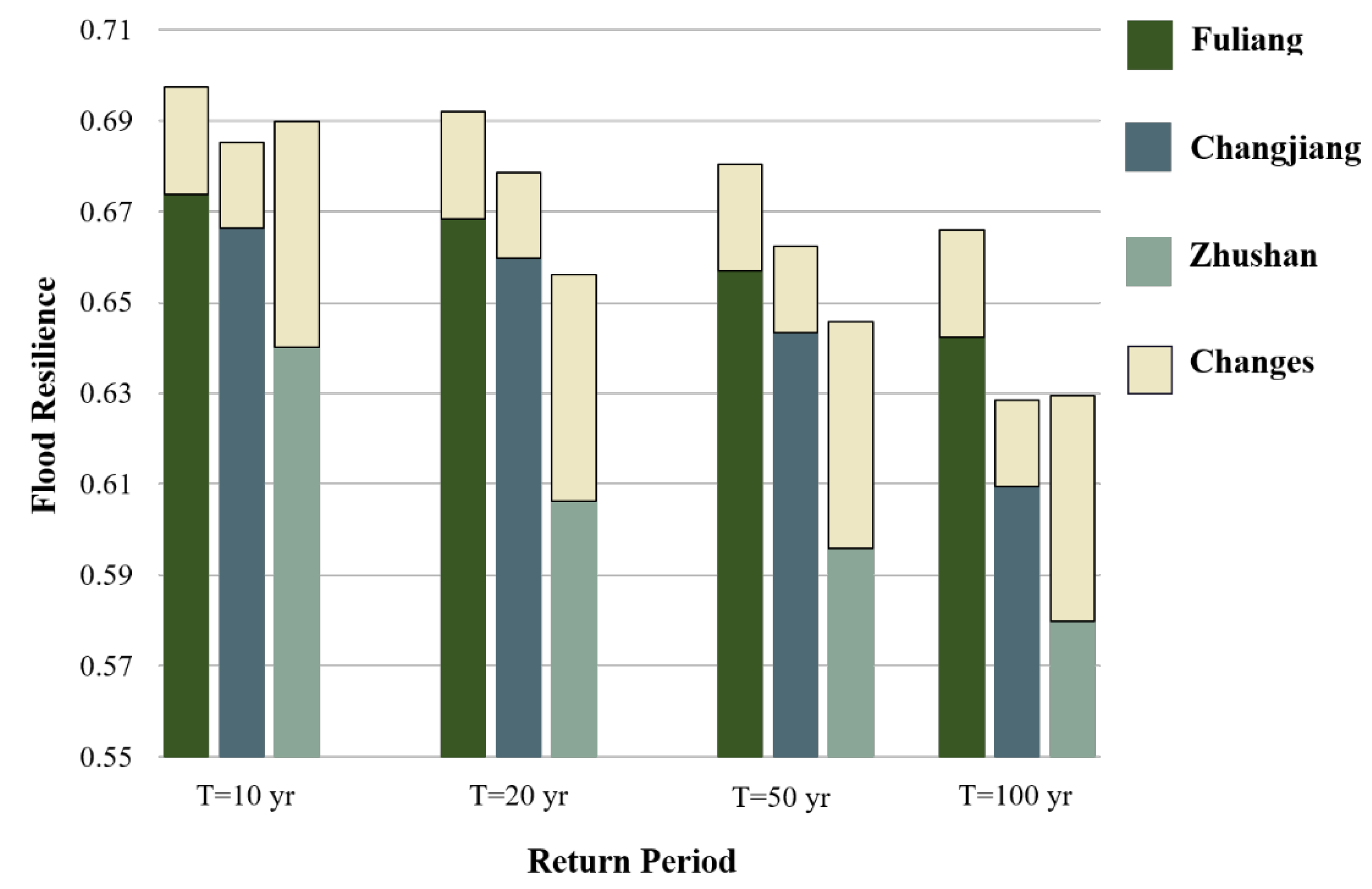
This paper provides the first quantitative comparison of resilience enhancement effects of engineering measures and adaptive measures. The findings show that in the future, the overall positive effect of adaptive measures on the three communities is three times higher than that of engineering measures. Compared with similar studies, resilience improvement strategies are evaluated in different resilience research frameworks [50,51], but there is a lack of quantitative and comparative analyses of specific measures. It is therefore unclear to what extent the measures will affect regional resilience and to what extent they will make a difference. This study explains that engineering measures have a significant effect on increasing resilience in some flood-prone communities, for the fact that the implementation of engineering measures has changed drainage and inundation. But there is a practical consideration that building flood protection infrastructures is exorbitantly expensive and implicates long-term costs [52] and that the government cannot invest regardless of the cost; in the meanwhile, there is not much more space to impose engineering measures due to a relatively saturated state of urbanization. Adaptive measures would be a better option at this point. With such a comparative analysis, the community policy makers could know how to develop valid strategies. The results of the quantitative analysis are not intended to discuss the details of implementing these measures, but it is important to give an example of the comparison between two types of measures in the perspective of flood resilience. From which the community policy makers should know how to develop valid strategies.
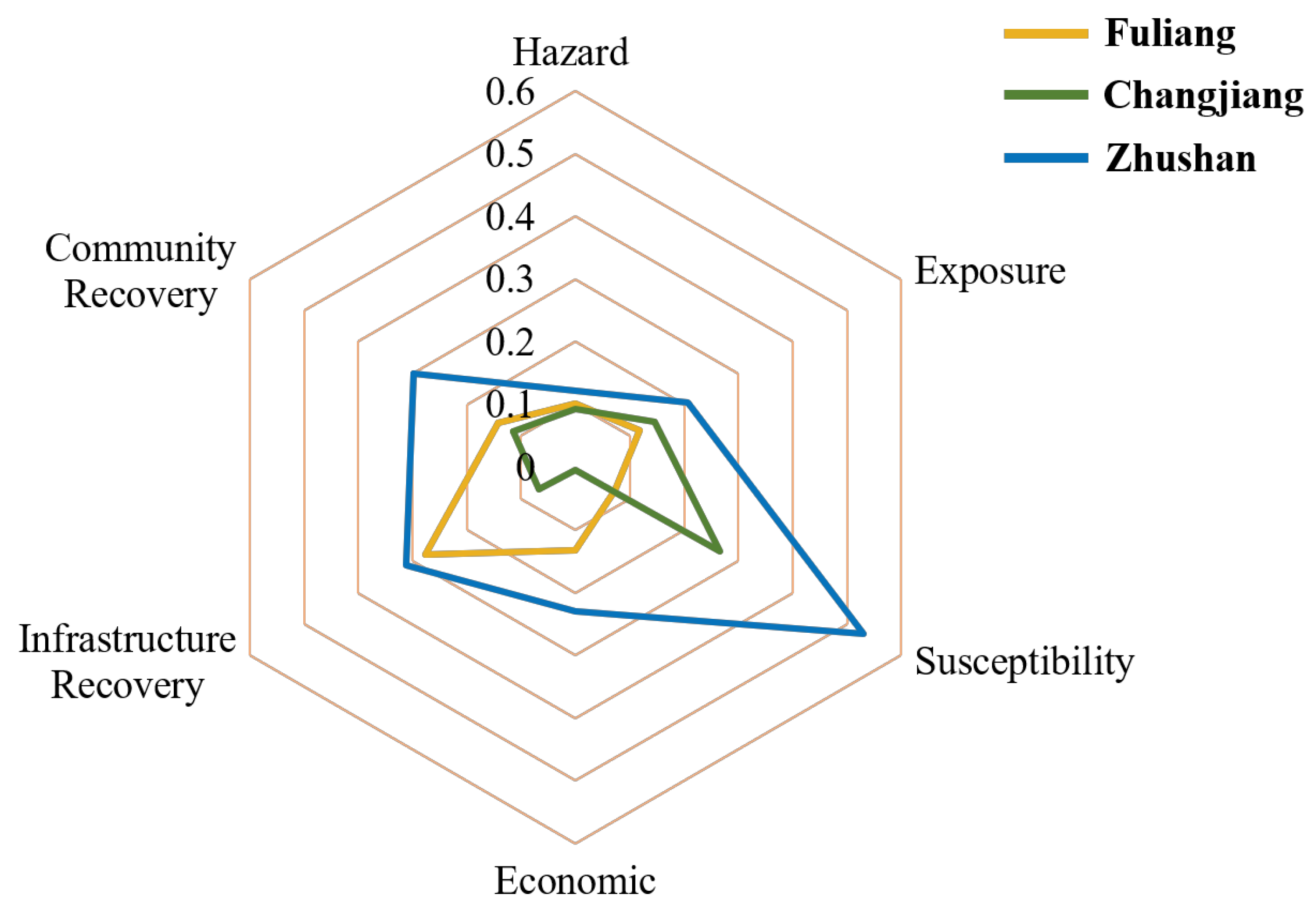
The results of the quantitative analysis indicate that the level of flood resilience is influenced by the awareness and preparedness of individual residents. Compared with the adaptive measures put forward in other resilience frameworks, the indicators of awareness and preparedness have been specially emphasized in this study, which has also been mentioned and found useful by other scholars [28]. We believe that individual residents’ risk awareness and preparedness play an important role in the implementation of community flood control work in a long-term perspective. In the future, attempts should be made to incorporate this criterion in community development plans, so as to form more complete disaster response strategies and resilience plans. The local government of Jingdezhen City is also interested in this work, which shows that the government as well as the community are aware of these issues and want to improve the flood control level of the city by enhancing flood resilience.
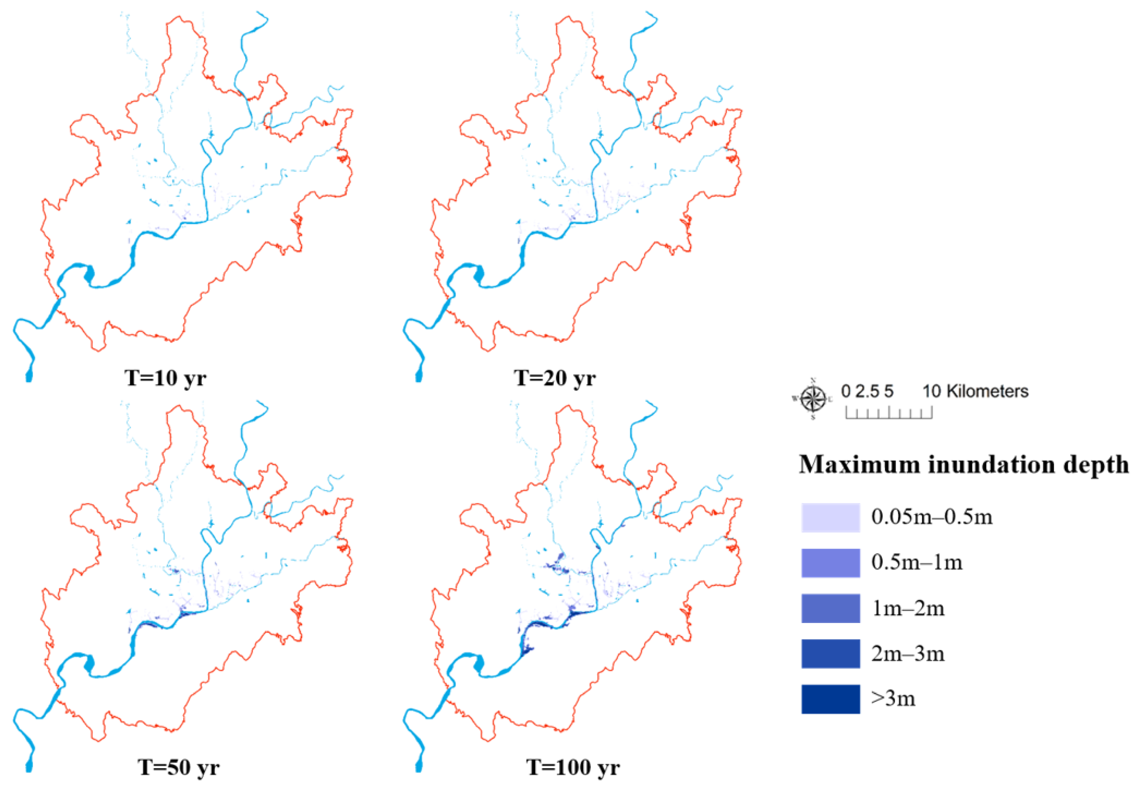
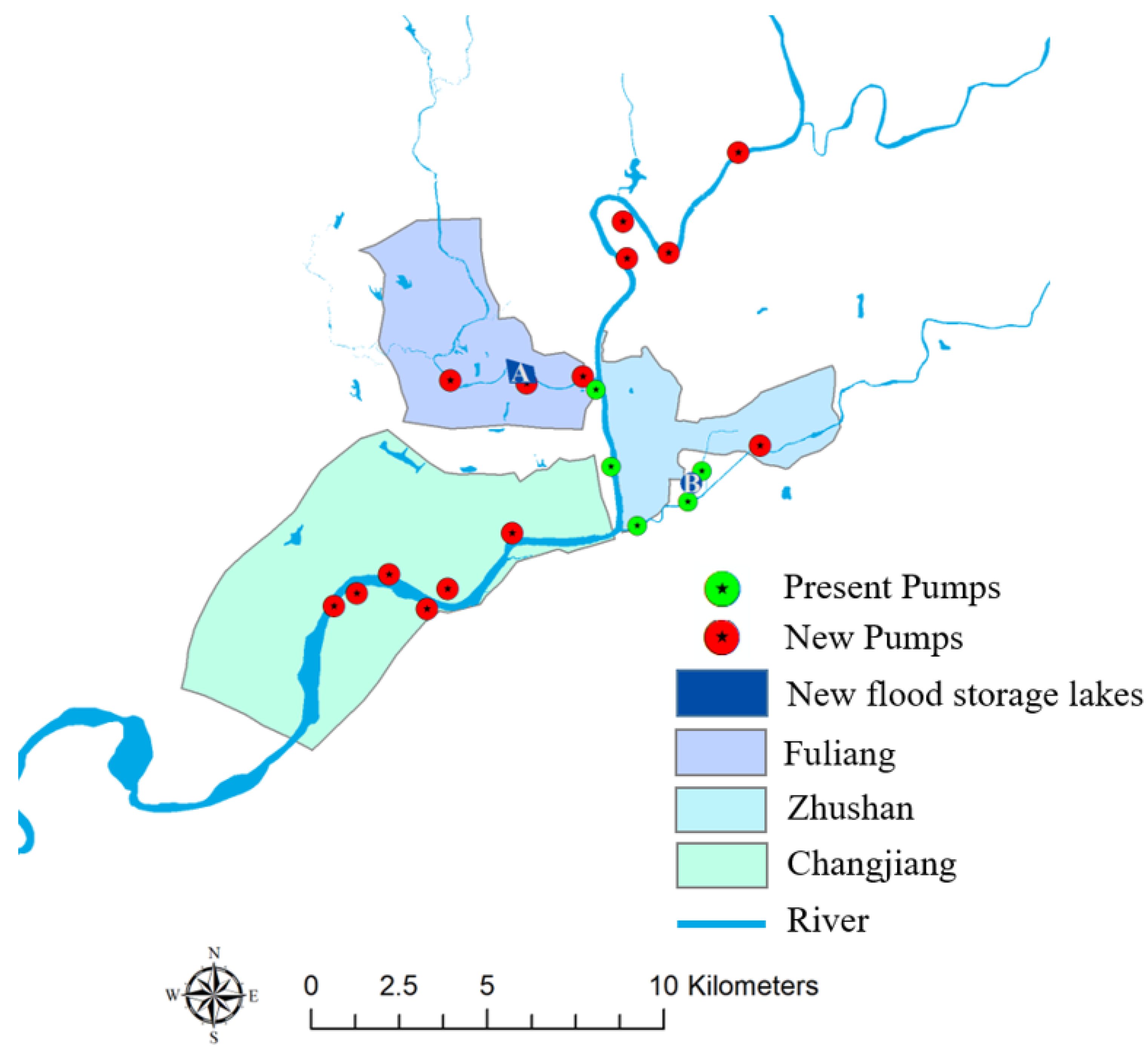
Three flood-prone communities in Jingdezhen are selected to show the resilience performance under different scenarios. The selected flood-prone communities are all exposed to long-term flood risk. But three communities have different natural and social-environmental characteristics: the layout of engineering measures, proximity to the river, and community management, which ultimately present variability in flood resilience. Therefore, the role of the community is very important in building a resilience framework closely related to the localized characteristics when implementing measures. Communities with a low level of engineering construction still have space and capacity to build flood control projects and should be given priority to making these engineering plans. Communities seated by the river should not be too relieved for the well-constructed dams and dykes to lose awareness and preparedness, especially those densely populated and with aging communities. Communities should provide adequate flood risk education to residents, encourage vulnerable people to participate in flood risk management, and set up temporary emergency shelters to improve flood response capacity in emergency situations.
The limitation of this study is the limited sample size and uneven sample distribution of the questionnaire survey in the three communities. Improvements are required in designing the survey process that could make the community indicator of awareness and preparedness more objective in the following surveys. The other limitation is about the evaluation of the economic recovery indicator, where the socio-economic property losses due to floods are generated based on depth–damage curves. It is an estimated quantity that can reflect the losses to some extent, but the evaluation could be better if statistical data are available.

6. Conclusions

This study explores the applicability and impact of two types of resilience enhancement measures (engineering measures and adaptive measures) on the study area, Jingdezhen City. An improved flood resilience assessment approach is used to quantify flood resilience. Three typical flood-prone communities were selected to assess their flood resilience levels under current and future scenarios to assess the impact of flood resilience enhancement measures. The main conclusions are the following:
  • The three flood-prone communities show different levels of flood resilience. Under different rainfall return periods, it shows that the flood resilience of the three flood-prone communities decrease significantly as the rainfall return period increases. Among them, the flood resilience of Fuliang is slightly higher than that of the other two. The flood resilience of Zhushan and Changjiang are lower, especially in Zhuanshan where the resilience level is the lowest. The results should be explained with the socio-economic attributes of the three flood-prone communities. Zhushan is an old community with the highest concentration of population and residential land, and its higher disaster exposure and vulnerability lead to the weakest ability to cope with flooding; Changjiang has the weakest level of infrastructure and economic recovery, but its flood resilience is slightly higher because the population and residential houses are relatively not that concentrated; Fuliang has the highest level of resilience among the three due to its high quality of drainage network infrastructure and low population density. The field study and the questionnaire survey results show that these three communities are still affected by flooding, indicating that there is much possibility to improve.
  • The results of flood resilience assessment under current and future scenarios show that the future scenario presents a lower level of flood resilience than the current. Under the development mode subject to the urban construction plan and the flood control plan of Jingdezhen City, the flood resilience will decrease in 2030, where the flood resilience of Fuliang, Changjiang, and Zhuanshan will decrease by 2.2%, 0.4%, and 0.5%, respectively. The results indicate that further urbanization and population increase in the future will exacerbate the threats posed by flooding and relying on planned flood protection engineering measures and permeability measures alone will not mitigate these threats. It indicates that the 2030 urban master plan of Jingdezhen City cannot fulfill the demand of future flood control development.
  • Two types of resilience enhancement measures are evaluated in the future scenario, which caused different influences on three flood-prone communities. The flood resilience of Fuliang, Changjiang, and Zhushan improved by 3.0%, 0.9%, and 2.1%, respectively, after implementing engineering measures. Flood resilience improved by 7.6%, 6.5%, and 7.1% after applying adaptive measures. The results show that engineering measures are suitable for the old communities with deficiency of renovation where they are sitting alongside the city main stream, for example the communities of Fuliang and Zhushan. Adaptive measures exhibit more efficiency in improving flood resilience in all communities, especially effective for the new city town Changjiang where engineering measures are nearly saturated.
In conclusion, this study investigates the applicability of two types of flood resilience enhancement strategies for typical flood-prone communities in Jingdezhen City. A managerial suggestion is to strengthen the role of communities in urban flood management. Communities can provide direct and effective ways to improve residents’ awareness and preparedness, including providing flood risk education, encouraging residents to participate in flood risk management, and carrying out emergency escape and rescue training. Many flood events have inspired us that residents are the main force in disaster prevention and post-disaster rescue. A healthy community disaster response and rescue system can most effectively help residents improve their ability to prevent and respond to flood events. Therefore, strategies should be further formulated to deepen the role of communities in building urban flood resilience.

Author Contributions

Conceptualization, Jingxuan Zhang, Huimin Wang and Jing Huang; methodology, Jingxuan Zhang; software, Jingxuan Zhang; validation, Jing Huang; formal analysis, Jingxuan Zhang; investigation, Jing Huang and Gaofeng Liu; resources, Dianchen Sun; data curation, Dianchen Sun; writing—original draft preparation, Jingxuan Zhang; writing—review and editing, Jing Huang; visualization, Jingxuan Zhang; funding acquisition, Huimin Wang All authors have read and agreed to the published version of the manuscript.

Funding

This work was supported by the National Natural Science Foundation of China [Grant No. 91846203, No. 42171081 and No. 72174054].

Institutional Review Board Statement

Not applicable.

Informed Consent Statement

Not applicable.

Data Availability Statement

Not applicable.

Acknowledgments

We would like to express our gratitude to the Jingdezhen Hydrology Bureau and the Jingdezhen Flood Control and Drought Relief Headquarters for the support to carry out the study.

Conflicts of Interest

The authors declare no conflict of interest.

References

  1. Pachauri, R.K.; Allen, M.R.; Barros, V.R.; Broome, J.; Cramer, W.; Christ, R.; Church, J.A.; Clarke, L.; Dahe, Q.; Dasgupta, P.; et al. Climate Change 2014: Synthesis Report. Contribution of Working Groups I, II and III to the Fifth Assessment Report of the Intergovernmental Panel on Climate Change; IPCC: Geneva, Switzerland, 2014. [Google Scholar]
  2. Eccles, R.; Zhang, H.; Hamilton, D.; Trancoso, R.; Syktus, J. Impacts of climate change on streamflow and floodplain inundation in a coastal subtropical catchment. Adv. Water Resour. 2021, 147, 103825. [Google Scholar] [CrossRef]
  3. Ghaderpour, E.; Vujadinovic, T.; Hassan, Q.K. Application of the Least-Squares Wavelet software in hydrology: Athabasca River Basin. J. Hydrol. Reg. Stud. 2021, 36, 100847. [Google Scholar] [CrossRef]
  4. Ndhlovu, G.Z.; Woyessa, Y.E. Evaluation of Streamflow under Climate Change in the Zambezi River Basin of Southern Africa. Water 2021, 13, 3114. [Google Scholar] [CrossRef]
  5. The 2020 Chinese Flood and Drought Disaster Prevention Bulletin. Available online: http://www.mwr.gov.cn/sj/tjgb/zgshzhgb/202112/t20211208_1554245.html (accessed on 12 April 2022).
  6. Department of Econimoc and Social Affairs. World Urbanization Prospects: The 2014 Revision, Highlights (ST/ESA/SER.A/352); United Nations: New York, NY, USA, 2014. [Google Scholar]
  7. Rus, K.; Kilar, V.; Koren, D. Resilience assessment of complex urban systems to natural disasters: A new literature review. Int. J. Disaster Risk Reduct. 2018, 31, 311–330. [Google Scholar] [CrossRef]
  8. Zhengzhao, L.; Dafang, F.; Junxian, W.; Kedong, M.; Junyu, Z. Urban resilience assessment model for waterlogging disasters and its application. J. Tsinghua Univ. (Sci. Technol.) 2022, 62, 266–276. [Google Scholar] [CrossRef]
  9. Yi, C.; Ruishan, C.; Yi, G. Research on social vulnerability and resilience of flood disaster in urban communities. Urban Archit. 2018, 304, 34–36. [Google Scholar]
  10. Tongyue, L.; Pinyi, N.; Chaolin, G. A review on research frameworks of resilient cities. Urban Plan. Forum 2014, 218, 23–31. [Google Scholar]
  11. Holling, C.S. Resilience and stability of ecological systems. Ann. Rev. Ecol. Syst. 1973, 4, 1–23. [Google Scholar] [CrossRef] [Green Version]
  12. Zhang, W.; Lin, P.; Wang, N.; Nicholson, C.; Xue, X. Probabilistic prediction of postdisaster functionality loss of community building portfolios considering utility disruptions. J. Struct. Eng. 2018, 144, 04018015. [Google Scholar] [CrossRef]
  13. Lu, X.; Liao, W.; Fang, D.; Lin, K.; Tian, Y.; Zhang, C.; Zheng, Z.; Zhao, P. Quantification of disaster resilience in civil engineering: A review. J. Saf. Sci. Resil. 2020, 1, 19–30. [Google Scholar] [CrossRef]
  14. Desouza, K.C.; Flanery, T.H. Designing, planning, and managing resilient cities: A conceptual framework. Cities 2013, 35, 89–99. [Google Scholar] [CrossRef]
  15. Koczyrkewycz, M.; Chaiechi, T.; Beg, R. How Resilient is the Investment Climate in Australia? Unpacking the Driving Factors. In Community Empowerment, Sustainable Cities, and Transformative Economies; Springer: Berlin/Heidelberg, Germany, 2022; pp. 31–48. [Google Scholar]
  16. Coaffee, J. Towards next-generation urban resilience in planning practice: From securitization to integrated place making. Plan. Pract. Res. 2013, 28, 323–339. [Google Scholar] [CrossRef]
  17. Simonovic, S.P.; Kundzewicz, Z.W.; Wright, N. Floods and the COVID-19 pandemic—A new double hazard problem. Wiley Interdiscip. Rev. Water 2021, 8, e1509. [Google Scholar] [CrossRef]
  18. Kong, J.; Zhang, C.; Simonovic, S.P. Optimizing the resilience of interdependent infrastructures to regional natural hazards with combined improvement measures. Reliab. Eng. Syst. Saf. 2021, 210, 107538. [Google Scholar] [CrossRef]
  19. Feng, K.; Wang, N.; Li, Q.; Lin, P. Measuring and enhancing resilience of building portfolios considering the functional interdependence among community sectors. Struct. Saf. 2017, 66, 118–126. [Google Scholar] [CrossRef]
  20. Allenby, B.; Fink, J. Toward inherently secure and resilient societies. Science 2005, 309, 1034–1036. [Google Scholar] [CrossRef] [PubMed] [Green Version]
  21. Leichenko, R. Climate change and urban resilience. Curr. Opin. Environ. Sustain. 2011, 3, 164–168. [Google Scholar] [CrossRef]
  22. Brown, A.; Dayal, A.; del Rio, C.R. From practice to theory: Emerging lessons from Asia for building urban climate change resilience. Environ. Urban 2012, 24, 531–556. [Google Scholar] [CrossRef] [Green Version]
  23. Saja, A.M.A.; Goonetilleke, A.; Teo, M.; Ziyath, A.M. A critical review of social resilience assessment frameworks in disaster management. Int. J. Disaster Risk Reduct. 2019, 35, 101096. [Google Scholar] [CrossRef]
  24. Rachunok, B.; Bennett, J.; Flage, R.; Nateghi, R. A path forward for leveraging social media to improve the study of community resilience. Int. J. Disaster Risk Reduct. 2021, 59, 102236. [Google Scholar] [CrossRef]
  25. Prabhakar, S.V.R.K.; Srinivasan, A.; Shaw, R. Climate change and local level disaster risk reduction planning: Need, opportunities and challenges. Mitig. Adapt. Strateg. Glob. Chang. 2009, 14, 7–33. [Google Scholar] [CrossRef]
  26. Kirshen, P.; Ballestero, T.; Douglas, E.; Hesed, C.D.M.; Ruth, M.; Paolisso, M.; Watson, C.; Giffee, P.; Vermeer, K.; Bosma, K. Engaging vulnerable populations in multi-level stakeholder collaborative urban adaptation planning for extreme events and climate risks—A case study of East Boston USA. J. Extrem. Events 2018, 5, 1850013. [Google Scholar] [CrossRef]
  27. Sánchez, F.G.; Solecki, W.D.; Batalla, C.R. Climate change adaptation in Europe and the United States: A comparative approach to urban green spaces in Bilbao and New York City. Land Use Policy 2018, 79, 164–173. [Google Scholar] [CrossRef]
  28. Hayashi, Y.; Suzuki, Y. Urban Resilience and Territorial Renewal; Tsinghua University Press: Beijing, China, 2016. [Google Scholar]
  29. Kodag, S.; Mani, S.K.; Balamurugan, G.; Bera, S. Earthquake and flood resilience through spatial Planning in the complex urban system. Prog. Disaster Sci. 2022, 14, 100219. [Google Scholar] [CrossRef]
  30. Yazdani, M.; Mojtahedi, M.; Loosemore, M.; Sanderson, D. A modelling framework to design an evacuation support system for healthcare infrastructures in response to major flood events. Prog. Disaster Sci. 2022, 13, 100218. [Google Scholar] [CrossRef]
  31. Zhang, C.; Kong, J.J.; Simonovic, S.P. Restoration resource allocation model for enhancing resilience of interdependent infrastructure systems. Saf. Sci. 2018, 102, 169–177. [Google Scholar] [CrossRef]
  32. Pescaroli, G.; Wicks, R.T.; Giacomello, G.; Alexander, D.E. Increasing resilience to cascading events: The M.OR.D.OR. scenario. Saf. Sci. 2018, 110, 131–140. [Google Scholar] [CrossRef]
  33. Liao, K.-H. A Theory on Urban Resilience to Floods—A Basis for Alternative Planning Practices. Ecol. Soc. 2012, 17, 48. [Google Scholar] [CrossRef]
  34. Datola, G.; Bottero, M.; De Angelis, E.; Romagnoli, F. Operationalising resilience: A methodological framework for assessing urban resilience through System Dynamics Model. Ecol. Model. 2022, 465, 109851. [Google Scholar] [CrossRef]
  35. Ba, R.; Deng, Q.; Liu, Y.; Yang, R.; Zhang, H. Multi-hazard Disaster Scenario Method and Emergency Management for Urban Resilience by Integrating Experiment–Simulation–Field Data. J. Saf. Sci. Resil. 2021, 2, 77–89. [Google Scholar] [CrossRef]
  36. Bertilsson, L.; Wiklund, K.; de Moura Tebaldi, I.; Rezende, O.M.; Verol, A.P.; Miguez, M.G. Urban flood resilience—A multi-criteria index to integrate flood resilience into urban planning. J. Hydrol. 2019, 573, 970–982. [Google Scholar] [CrossRef]
  37. Chen, K.-F.; Leandro, J. A Conceptual Time-Varying Flood Resilience Index for Urban Areas: Munich City. Water 2019, 11, 830. [Google Scholar] [CrossRef] [Green Version]
  38. Laeni, N.; van den Brink, M.; Arts, J. Is Bangkok becoming more resilient to flooding? A framing analysis of Bangkok’s flood resilience policy combining insights from both insiders and outsiders. Cities 2019, 90, 157–167. [Google Scholar] [CrossRef]
  39. Handayani, W.; Fisher, M.R.; Rudiarto, I.; Setyono, J.S.; Foley, D. Operationalizing resilience: A content analysis of flood disaster planning in two coastal cities in Central Java, Indonesia. Int. J. Disaster Risk Reduct. 2019, 35, 11. [Google Scholar] [CrossRef]
  40. Wang, X.; Xie, Y.; Li, Y. Studies on Climate Change and Development Strategies for the Resilient Cities in China; Science Press: Beijing, China, 2016; pp. 26–31. (In Chinese) [Google Scholar]
  41. Hegger, D.; Driessen, P.; Bakker, M.; Alexander, M.; Beyers, J.-C.; Buijze, A.; Chorynski, A.; Crabbé, A.; Deketelaere, K.; Delvaux, B.; et al. A View on More Resilient Flood Risk Governance: Key Conclusions of the Star-Flood Project; STAR-FLOOD Consortium; Utrecht University: Utrecht, The Netherlands, 2016. [Google Scholar]
  42. Mees, H.; Crabbé, A.; Alexander, M.; Kaufmann, M.; Bruzzone, S.; Lévy, L.; Lewandowski, J. Coproducing flood risk management through citizen involvement: Insights from cross-country comparison in Europe. Ecol. Soc. 2016, 21, 7. [Google Scholar] [CrossRef]
  43. Spegel, E. Valuing the reduction of floods: Public officials’ versus citizens’ preferences. Clim. Risk Manag. 2017, 18, 1–14. [Google Scholar] [CrossRef]
  44. DHI. Mike Flood 1D-2D Modelling User Manual. 2019. Available online: https://manuals.mikepoweredbydhi.help/latest/MIKE_FLOOD.htm (accessed on 27 December 2021).
  45. DHI. Mike Urban User Guide. 2019. Available online: https://www.mikepoweredbydhi.com/download/product-documentation (accessed on 27 December 2021).
  46. DHI. Mike 21 Hydrodynamic Module User Guide. 2017. Available online: https://manuals.mikepoweredbydhi.help/latest/MIKE_21.htm (accessed on 27 December 2021).
  47. SRTM 90m DEM Digital Elevation Database. Available online: https://srtm.csi.cgiar.org/ (accessed on 13 May 2019).
  48. Fuchs, S.; Karagiorgos, K.; Kitikidou, K.; Maris, F.; Paparrizos, S.; Thaler, T. Flood risk perception and adaptation capacity: A contribution to the socio-hydrology debate. In Proceedings of the 19th EGU General Assembly, EGU2017, Vienna, Austria, 23–28 April 2017. [Google Scholar]
  49. Gao, S.; Cui, S.; Zhong, Q.; Wang, J. Current situation of cognition level of community disaster risk and its countermeasures. City Disaster Reduct. 2013, 4, 21–23. [Google Scholar]
  50. Heinzlef, C.; Becue, V.; Serre, D. Operationalizing urban resilience to floods in embanked territories—Application in Avignon, Provence Alpes Cote d’azur region. Saf. Sci. 2019, 118, 181–193. [Google Scholar] [CrossRef]
  51. Karavokiros, G.; Lykou, A.; Koutiva, I.; Batica, J.; Kostaridis, A.; Alves, A.; Makropoulos, C. Providing Evidence-Based, Intelligent Support for Flood Resilient Planning and Policy: The PEARL Knowledge Base. Water 2016, 8, 392. [Google Scholar] [CrossRef]
  52. Genovese, E.; Thaler, T. The benefits of flood mitigation strategies: Effectiveness of integrated protection measures. AIMS Geosci. 2020, 6, 459–472. [Google Scholar] [CrossRef]
Figure 1. Study area of Jingdezhen City in Jiangxi Province, China. Three typical flood-prone communities of Fuliang, Changjiang, and Zhushan are selected in central Jingdezhen City.
Ijgi 11 00285 g001
Figure 2. Maximum inundation depth map with four return periods in Jingdezhen city.
Ijgi 11 00285 g002
Figure 3. Research framework.
Ijgi 11 00285 g003
Figure 4. Locations of engineering measures.
Ijgi 11 00285 g004
Figure 5. Urban flood resilience in three flood-prone communities under different return periods.
Ijgi 11 00285 g005
Figure 6. Spider diagram of flood resilience indicators under T = 20 yr.
Ijgi 11 00285 g006
Figure 7. Impacts of the community indicator of ‘awareness and preparedness’: the bottom half of the bar chart in three colors shows flood resilience without community indicator in Fuliang, Changjiang, and Zhushan communities; the top half of the bar chart in yellow exhibits the changes in flood resilience if community indicator is considered.
Ijgi 11 00285 g007
Figure 8. Urban flood resilience in current and future scenarios.
Ijgi 11 00285 g008
Table 1. Adaptive measures in four categories.
CategoriesAdaptive Measures
PlanningDevelop participatory emergency plans for the community and the public
Set up temporary and long-term emergency shelters and stockpile related emergency supplies
Survey of disaster-vulnerable populations and housing and regular inspections
EducationEstablish a standardized and complete disaster reduction file for community residents, recording text, photos, video information, etc.
Give full play to the role of the community, the organization of disaster risk reduction publicity and education, disaster prevention, and mitigation training
ParticipationThe community regularly conducts emergency drills for residents
AwarenessConduct regular disaster risk awareness assessments of residents
Residents are equipped with the necessary disaster prevention equipment and are familiar with escape routes and places of refuge
Enhance residents’ personal risk awareness and resilience to disaster risks
Table 2. Urban flood resilience assess framework.
Urban Flood Resilience
Resistance CapacityRecovery Capacity
HazardExposureSusceptibilityEconomic RecoveryInfrastructure RecoveryCommunity Recovery
Flood DepthHousehold DensityFlooded householdLoss/IncomeDrainage Awareness and Preparedness
I d I p I l u I e r I i r I c r
Table 3. Four aspects of the questionnaire survey.
AspectContents
U 1 Official flood education or evacuation training organized by community
U 2 Knowledge and skills coping with waterlogging
U 3 Flood experience
U 4 Precautionary measures such as preparing emergency materials
Table 4. Score of four levels.
LevelScore
Strongly0.75–1
Moderately0.5–0.75
Slightly0.25–0.5
Never0–0.25
Table 5. The promotion goals of the ‘awareness and preparedness’ indicator after applying adaptive measures in 2030.
Components of ‘Awareness and Preparedness’ IndicatorIncrease by Percentage
Education and training80%
Flood knowledge30%
Flood experience60%
Precautionary measures50%
Table 6. Changes of resilience after implementing engineering measures.
Area% of Resilience Change in the Future Scenario% of Resilience Change Applying Engineering Measure 1% of Resilience Change Applying Engineering Measure 2% of Resilience Change Applying Engineering Measure 3
Fuliang−2.2%1.5%1.6%3.0%
Changjiang−0.4%0.9%00.9%
Zhushan−0.5%2.1%0.01%2.1%
Table 7. Comparison between engineering measures and adaptive measures.
Area% of Resilience Change in the Future Scenario% of Resilience Change Applying Engineering Measures % of Resilience Change Applying Adaptive Measures
Fuliang−2.2%3.0%7.6%
Changjiang−0.4%0.9%6.5%
Zhushan−0.5%2.1%7.1%
Publisher’s Note: MDPI stays neutral with regard to jurisdictional claims in published maps and institutional affiliations.

