
Impact of Digital and Non-Digital Urban Participatory Approaches on Public Access Conditions: An Evaluation Framework


Abstract
:1. Introduction
2. Public Participation Definition and Citizens’ Empowerment
2.1. Public Involvement in Urban Decision-Making
2.2. Digital Technologies to Support Participatory Approaches
3. Access Barriers in Participatory Approaches
4. A Framework for Evaluating Citizens’ Access
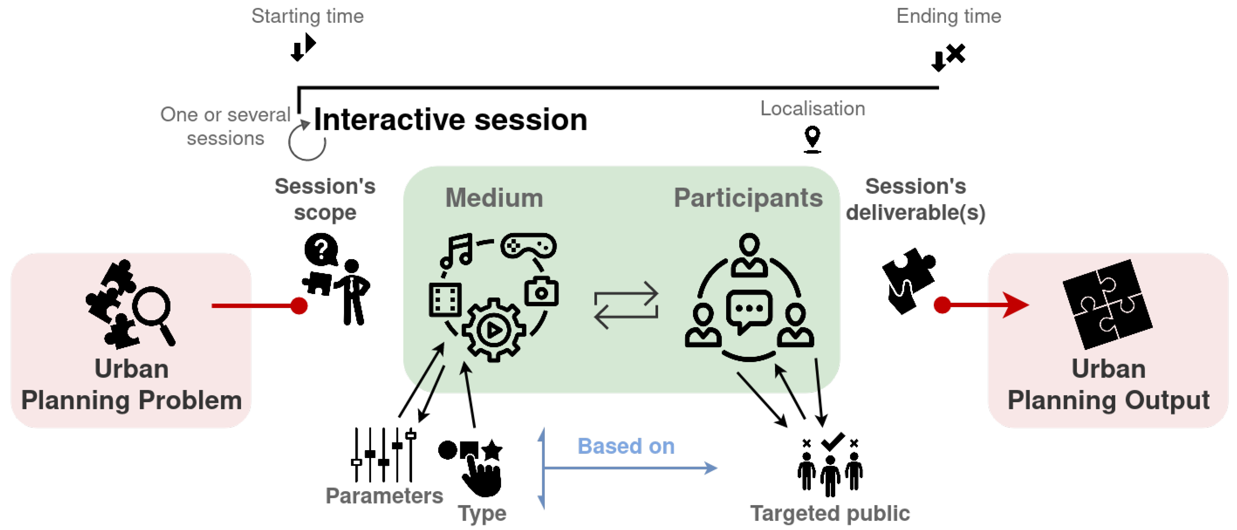
4.1. Access Dimensions for Interactive Sessions
4.2. Attractiveness—A Meaningful Dimension of Access
5. Contextualization of the Access Evaluation Framework
5.1. Illustrative Case: Master Plan Revision of a Swiss Municipality, Anterior Access Analysis of Medium Alternatives
5.1.1. Project Description
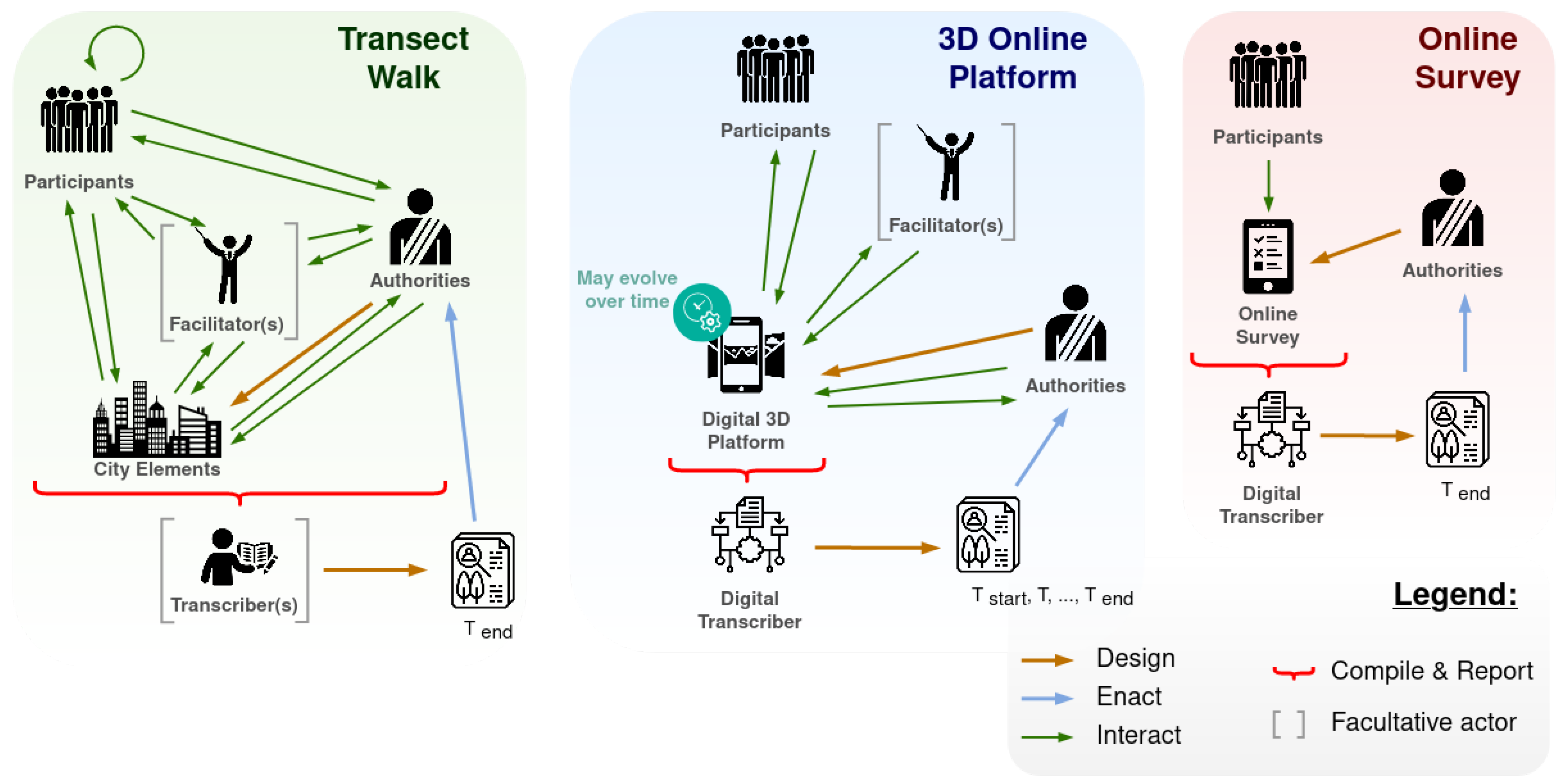
5.1.2. Description of Medium Alternatives
5.1.3. Access Evaluation of Medium Alternatives
5.1.4. Outcome: Selection of the Medium
5.2. Illustrative Case: ZImeysaver, a Posteriori Access Evaluation
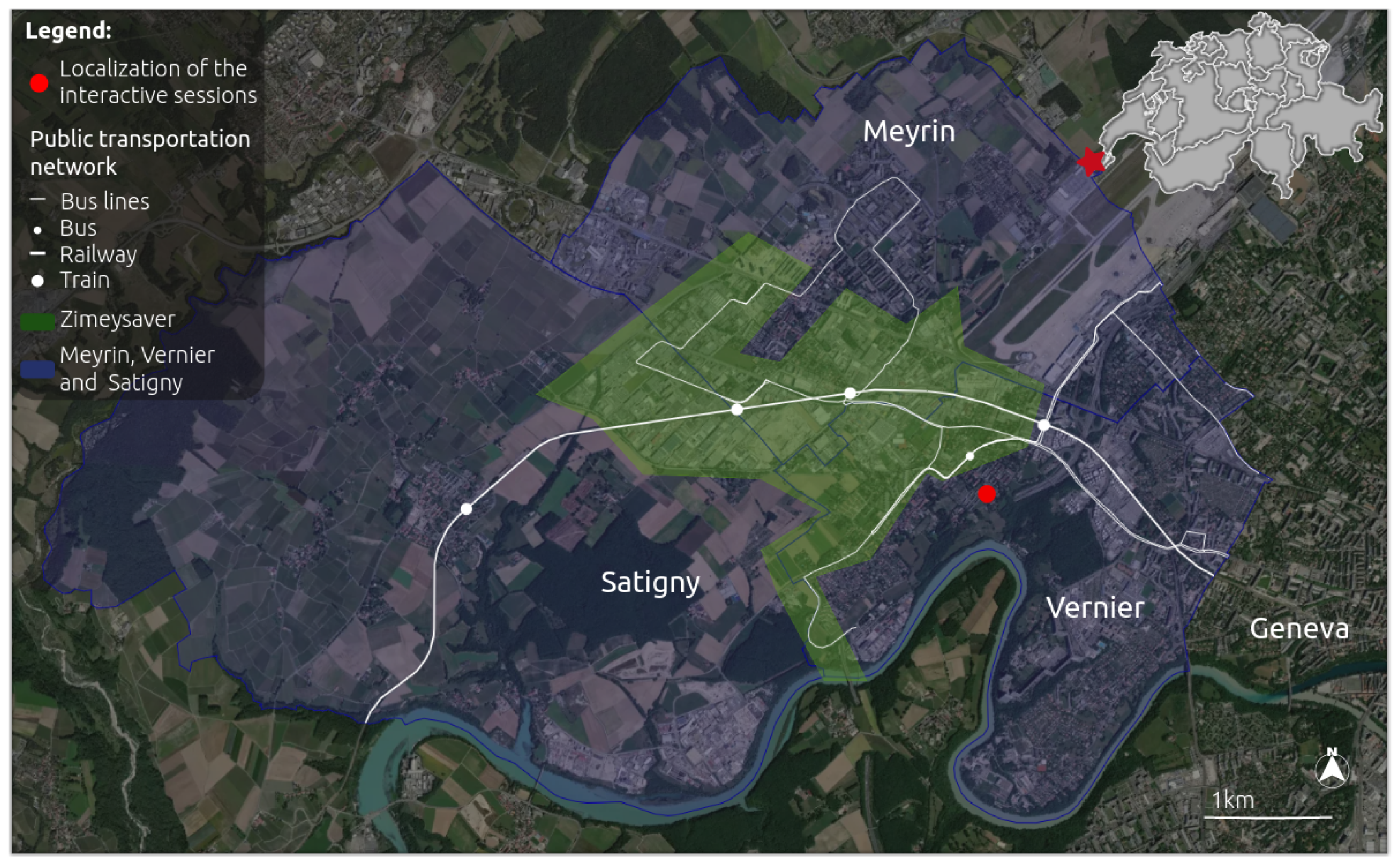
5.2.1. Project Description
5.2.2. Interactive Sessions’ Description
5.2.3. Access Evaluation
5.2.4. Including Participants’ Insights within the Access Evaluation Framework
6. Access Evaluation Framework Implications for Participatory Approaches
7. Conclusions
8. URLs
Author Contributions
Funding
Institutional Review Board Statement
Informed Consent Statement
Acknowledgments
Conflicts of Interest
References
- Blatrix, C. La démocratie participative en représentation. Soc. Contemp. 2009, 74, 97. [Google Scholar] [CrossRef]
- Jho, W.; Song, K.J. Institutional and technological determinants of civil e-Participation: Solo or duet? Gov. Inf. Q. 2015, 32, 488–495. [Google Scholar] [CrossRef] [Green Version]
- Arnstein, S.R. A Ladder Of Citizen Participation. J. Am. Inst. Plan. 1969, 35, 216–224. [Google Scholar] [CrossRef] [Green Version]
- Torre, A.; Beuret, J.E. Proximités Territoriales; Economica: Paris, France, 2012; p. 105. [Google Scholar]
- Hrivnák, M.; Moritz, P.; Melichová, K.; Roháčiková, O.; Pospišová, L. Designing the Participation on Local Development Planning: From Literature Review to Adaptive Framework for Practice. Societies 2021, 11, 19. [Google Scholar] [CrossRef]
- Innes, J.E.; Booher, D.E. Reframing public participation: Strategies for the 21st century. Plan. Theory Pract. 2004, 5, 419–436. [Google Scholar] [CrossRef]
- Baker, M.; Coaffee, J.; Sherriff, G. Achieving successful participation in the new UK spatial planning system. Plan. Pract. Res. 2007, 22, 79–93. [Google Scholar] [CrossRef]
- Li, W.; Feng, T.; Timmermans, H.J.; Li, Z.; Zhang, M.; Li, B. Analysis of citizens’ motivation and participation intention in urban planning. Cities 2020, 106, 102921. [Google Scholar] [CrossRef]
- Fung, A. Putting the Public Back into Governance: The Challenges of Citizen Participation and Its Future. Public Adm. Rev. 2015, 75, 513–522. [Google Scholar] [CrossRef]
- Sintomer, Y. Du savoir d’usage au métier de citoyen ? Raisons Polit. 2008, 31, 115. [Google Scholar] [CrossRef]
- Rick, L.; Lawrence, D.A.D. Choosing Public Participation Methods for Natural Resources: A Context-Specific Guide. Soc. Nat. Resour. 2001, 14, 857–872. [Google Scholar]
- Akbar, A.; Flacke, J.; Martinez, J.; van Maarseveen, M.F. Spatial Knowledge: A Potential to Enhance Public Participation? Sustainability 2020, 12, 5025. [Google Scholar] [CrossRef]
- Baeckelandt, S. L’impératif délibératif, une reconfiguration des modalités de négociation entre pouvoir et société civile organisée? In Proceedings of the Actes des Sixièmes Journées Doctorales Sur la Participation et la Démocratie Participative-GIS Démocratie et Participation, La Rochelle, France, 25–27 November 2020. [Google Scholar]
- Obama, B. Remarks of the President in Welcoming Senior Staff and Cabinet Secretaries to the White House. 2009. Available online: https://obamawhitehouse.archives.gov/the-press-office/remarks-president-welcoming-senior-staff-and-cabinet-secretaries-white-house (accessed on 17 August 2021).
- Fortin, M.J.; Fournis, Y. Dossier «Territoires en transition environnementale»–Vers une définition ascendante de l’acceptabilité sociale: Les dynamiques territoriales face aux projets énergétiques au Québec. Nat. Sci. Soc. 2014, 22, 231–239. [Google Scholar] [CrossRef] [Green Version]
- Dechézelles, S.; Olive, M. Introduction: Lieux familiers, lieux disputés–dynamiques des mobilisations localisées. In Norois. Environnement, Aménagement, Société; Presses Universitaires de Rennes: Rennes, France, 2016; pp. 7–21. [Google Scholar]
- Saucier, C.; Côté, G.; Feurtey, É.; Fortin, M.J.; Jean, B.; Lafontaine, D.; Guillemette, M.; Méthot, J.F.; Wilson, J. Développement Territorial et Filière Éolienne. Des installations Éoliennes Socialement Acceptables: Élaboration d’un Modèle D’évaluation des Projets Dans une Perspective de Développement Territorial Durable, Unité de recherche sur le développement territorial durable et la filière éolienne, rattachée au Centre de recherche sur le développement territorial (CRDT); Université du Québec à Rimouski: Rimouski, QC, Canada, 2009. [Google Scholar]
- Sebastien, L. L’attachement au lieu, vecteur de mobilisation collective? Norois 2016, 238–239, 23–41. [Google Scholar] [CrossRef] [Green Version]
- Dechézelles, S. Au-delà du Nimby: Registres de justification et économie des mobilisations contre des projets de parcs éoliens. Études de cas audois et ariégeois. J. Int. Sociol. L’énergie 2015. Available online: http://www.socio-energie2015.fr/?page_id=1816 (accessed on 17 August 2021).
- Wüstenhagen, R.; Wolsink, M.; Bürer, M.J. Social acceptance of renewable energy innovation: An introduction to the concept. Energy Policy 2007, 35, 2683–2691. [Google Scholar] [CrossRef] [Green Version]
- Martínez, M. The Citizen Participation of Urban Movements in Spatial Planning: A Comparison between Vigo and Porto. Int. J. Urban Reg. Res. 2011, 35, 147–171. [Google Scholar] [CrossRef] [Green Version]
- Hasler, S.; Chenal, J.; Soutter, M. Digital Tools as a Means to Foster Inclusive, Data-informed Urban Planning. Civ. Eng. Archit. 2017, 5, 230–239. [Google Scholar] [CrossRef]
- Evans-Cowley, J.; Hollander, J. The New Generation of Public Participation: Internet-based Participation Tools. Plan. Pract. Res. 2010, 25, 397–408. [Google Scholar] [CrossRef]
- Leao, S.; Izadpahani, P. Factors Motivating Citizen Engagement in Mobile Sensing: Insights from a Survey of Non-Participants. J. Urban Technol. 2016, 23, 85–103. [Google Scholar] [CrossRef]
- Pickering, T.; Minnery, J. Scale and Public Participation: Issues in Metropolitan Regional Planning. Plan. Pract. Res. 2012, 27, 249–262. [Google Scholar] [CrossRef]
- Knight Foundation; Rita Allen Foundation. Scaling Civic Tech: Paths to a Sustainable Future. 2017. Available online: https://knightfoundation.org/wp-content/uploads/2020/03/Scaling_Civic_Tech_final.pdf (accessed on 21 May 2021).
- Civic Tech Field. A Timeline of Civic Tech Tells a Data-Driven Story of the Field. 2019. Available online: https://civictech.guide/a-timeline-of-civic-tech-tells-a-data-driven-story-of-the-field/ (accessed on 18 November 2019).
- Brabham, D.C.; Guth, K.L. The Deliberative Politics of the Consultative Layer: Participation Hopes and Communication as Design Values of Civic Tech Founders. J. Commun. 2017, 67, 445–475. [Google Scholar] [CrossRef] [Green Version]
- O’Reilly, T. What Is Web 2.0: Design Patterns and Business Models for the Next Generation of Software; MPRA Paper 4578; University Library of Munich: Munich, Germany, 2007. [Google Scholar]
- OECD. Promise and Problems of E-Democracy Challenges of Online Citizen Engagement: Challenges of Online Citizen Engagement; OECD Publishing: Paris, France, 2004. [Google Scholar]
- Gün, A.; Demir, Y.; Pak, B. Urban design empowerment through ICT-based platforms in Europe. Int. J. Urban Sci. 2020, 24, 189–215. [Google Scholar] [CrossRef]
- Falco, E.; Kleinhans, R. Digital participatory platforms for co-production in urban development. Int. J. E-Plan. Res. 2018, 7, 52–79. [Google Scholar] [CrossRef] [Green Version]
- Schrock, A.R. What is Civic Tech? Defining a Practice of Technical Pluralism. In The Right to the Smart City; Emerald Publishing Limited: Bingley, UK, 2019; pp. 125–133. [Google Scholar]
- Al-Kodmany, K. Using visualization techniques for enhancing public participation in planning and design: Process, implementation, and evaluation. Landsc. Urban Plan. 1999, 45, 37–45. [Google Scholar] [CrossRef]
- Talen, E. Bottom-Up GIS: A New Tool for Individual and Group Expression in Participatory Planning. J. Am. Plan. Assoc. 2000, 66, 279–294. [Google Scholar] [CrossRef]
- Zhang, S. Public participation in the Geoweb era: Defining a typology for geo-participation in local governments. Cities 2019, 85, 38–50. [Google Scholar] [CrossRef]
- Fechner, T.; Kray, C. Georeferenced Open Data and Augmented Interactive Geo-Visualizations as Catalysts for Citizen Engagement. JeDEM eJournal eDemocracy Open Gov. 2014, 6, 14–35. [Google Scholar] [CrossRef] [Green Version]
- Rinner, C. Argumentation Maps: GIS-Based Discussion Support for On-Line Planning. Environ. Plan. B Plan. Des. 2001, 28, 847–863. [Google Scholar] [CrossRef]
- Pánek, J. Emotional Maps: Participatory Crowdsourcing of Citizens´ Perceptions of Their Urban Environment. Cartogr. Perspect. 2018, 17–29. [Google Scholar] [CrossRef]
- Haklay, M.; Jankowski, P.; Zwoliński, Z. Selected modern methods and tools for public participation in urban planning—A review. Quaest. Geogr. 2018, 37, 127–149. [Google Scholar] [CrossRef] [Green Version]
- Czepkiewicz, M.; Jankowski, P.; Zwoliński, Z. Geo-questionnaire: A spatially explicit method for eliciting public preferences, behavioural patterns, and local knowledge—An overview. Quaest. Geogr. 2018, 37, 177–190. [Google Scholar] [CrossRef] [Green Version]
- Brown, G.; Kyttä, M. Key issues and priorities in participatory mapping: Toward integration or increased specialization? Appl. Geogr. 2018, 95, 1–8. [Google Scholar] [CrossRef]
- Bugs, G.; Granell, C.; Fonts, O.; Huerta, J.; Painho, M. An assessment of Public Participation GIS and Web 2.0 technologies in urban planning practice in Canela, Brazil. Cities 2010, 27, 172–181. [Google Scholar] [CrossRef]
- Liu, W.; Dugar, S.; McCallum, I.; Thapa, G.; See, L.; Khadka, P.; Budhathoki, N.; Brown, S.; Mechler, R.; Fritz, S.; et al. Integrated Participatory and Collaborative Risk Mapping for Enhancing Disaster Resilience. ISPRS Int. J. Geo-Inf. 2018, 7, 68. [Google Scholar] [CrossRef] [Green Version]
- Pedregal, B.; Laconi, C.; del Moral, L. Promoting Environmental Justice through Integrated Mapping Approaches: The Map of Water Conflicts in Andalusia (Spain). ISPRS Int. J. Geo-Inf. 2020, 9, 130. [Google Scholar] [CrossRef] [Green Version]
- Jacquinod, F.; Bonaccorsi, J. Studying Social Uses of 3D Geovisualizations: Lessons Learned from Action-Research Projects in the Field of Flood Mitigation Planning. ISPRS Int. J. Geo-Inf. 2019, 8, 84. [Google Scholar] [CrossRef] [Green Version]
- Teyseyre, A.R.; Campo, M.R. An overview of 3D software visualization. IEEE Trans. Vis. Comput. Graph. 2009, 15, 87–105. [Google Scholar] [CrossRef] [PubMed]
- Çöltekin, A.; Lokka, I.; Zahner, M. On the Usability and Usefulness of 3d (Geo)Visualizations—A Focus on Virtual Reality Environments. ISPRS Int. Arch. Photogramm. Remote Sens. Spat. Inf. Sci. 2016, XLI-B2, 387–392. [Google Scholar]
- Judge, S.; Harrie, L. Visualizing a Possible Future: Map Guidelines for a 3D Detailed Development Plan. J. Geovisualiz. Spat. Anal. 2020, 4, 1–21. [Google Scholar] [CrossRef]
- Alatalo, T.; Pouke, M.; Koskela, T.; Hurskainen, T.; Florea, C.; Ojala, T. Two real-world case studies on 3D web applications for participatory urban planning. In Proceedings of the 22nd International Conference on 3D Web Technology-Web3D ’17, Brisbane, QLD, Australia, 5–7 June 2017. [Google Scholar]
- Virtanen, J.P.; Hyyppä, H.; Kurkela, M.; Vaaja, M.T.; Puustinen, T.; Jaalama, K.; Julin, A.; Pouke, M.; Kukko, A.; Turppa, T.; et al. Browser based 3D for the built environment. Nord. J. Surv. Real Estate Res. 2018, 13, 54–76. [Google Scholar] [CrossRef]
- Hu, Y.; Lv, Z.; Wu, J.; Janowicz, K.; Zhao, X.; Yu, B. A multistage collaborative 3D GIS to support public participation. Int. J. Digit. Earth 2015, 8, 212–234. [Google Scholar] [CrossRef]
- Sieber, R.; Robinson, P.; Johnson, P.; Corbett, J. Doing Public Participation on the Geospatial Web. Ann. Am. Assoc. Geogr. 2016, 106, 1030–1046. [Google Scholar] [CrossRef]
- Kahila-Tani, M.; Kytta, M.; Geertman, S. Does mapping improve public participation? Exploring the pros and cons of using public participation GIS in urban planning practices. Landsc. Urban Plan. 2019, 186, 45–55. [Google Scholar] [CrossRef]
- Surowiecki, J. The Wisdom of Crowds: Why the Many Are Smarter Than the Few and How Collective Wisdom Shapes Business, Economies, Societies, and Nations; Doubleday Books: New York, NY, USA, 2004. [Google Scholar]
- Bryson, J.M.; Quick, K.S.; Slotterback, C.S.; Crosby, B.C. Designing Public Participation Processes. Public Adm. Rev. 2013, 73, 23–34. [Google Scholar] [CrossRef]
- Barnes, M.; Newman, J.; Knops, A.; Sullivan, H. Constituting ’the public’ in public participation. Public Adm. 2003, 81, 379–399. [Google Scholar] [CrossRef]
- Brody, S.D.; Godschalk, D.R.; Burby, R.J. Mandating Citizen Participation in Plan Making: Six Strategic Planning Choices. J. Am. Plan. Assoc. 2003, 69, 245–264. [Google Scholar] [CrossRef]
- McLain, R.J.; Banis, D.; Todd, A.; Cerveny, L.K. Multiple methods of public engagement: Disaggregating socio-spatial data for environmental planning in western Washington, USA. J. Environ. Manag. 2017, 204, 61–74. [Google Scholar] [CrossRef] [Green Version]
- Devine-Wright, P. Beyond NIMBYism: Towards an integrated framework for understanding public perceptions of wind energy. Wind Energy 2005, 8, 125–139. [Google Scholar] [CrossRef]
- Rowe, G.; Frewer, L.J. Public Participation Methods: A Framework for Evaluation. Sci. Technol. Hum. Values 2000, 25, 3–29. [Google Scholar] [CrossRef]
- Levesque, J.F.; Harris, M.F.; Russell, G. Patient-centred access to health care: Conceptualising access at the interface of health systems and populations. Int. J. Equity Health 2013, 12, 18. [Google Scholar] [CrossRef] [PubMed] [Green Version]
- Penchansky, R.; Thomas, J.W. The concept of access: Definition and relationship to consumer satisfaction. Med. Care 1981, 19, 127–140. [Google Scholar] [CrossRef]
- Saurman, E. Improving access: Modifying Penchansky and Thomas’s Theory of Access. J. Health Serv. Res. Policy 2016, 21, 36–39. [Google Scholar] [CrossRef] [PubMed]
- Tokarchuk, O.; Cuel, R.; Zamarian, M. Analyzing Crowd Labor and Designing Incentives for Humans in the Loop. IEEE Internet Comput. 2012, 16, 45–51. [Google Scholar] [CrossRef]
- Lotfian, M.; Ingensand, J.; Brovelli, M.A. A Framework for Classifying Participant Motivation that Considers the Typology of Citizen Science Projects. ISPRS Int. J. Geo-Inf. 2020, 9, 704. [Google Scholar] [CrossRef]
- Marzouki, A.; Mellouli, S.; Daniel, S. A qualitative framework for data collection and analysis in Participation processes. In Proceedings of the 20th Annual International Conference on Digital Government Research on-dg.o 2019, Dubai, United Arab Emirates, 18–20 June 2019. [Google Scholar]
- ZIMEYSAVER. 2017. Available online: https://www.ge.ch/node/3454 (accessed on 9 November 2020).
- Chassin, T.; Ingensand, J.; Lotfian, M.; Ertz, O.; Joerin, F. Challenges in creating a 3D participatory platform for urban development. Adv. Cartogr. GISci. ICA 2019, 1, 1–8. [Google Scholar] [CrossRef]
- Hopkins, D. The emancipatory limits of participation in planning: Equity and power in deliberative plan-making in Perth, Western Australia. Town Plan. Rev. 2010, 81, 55–81. [Google Scholar] [CrossRef]
- Münster, S.; Georgi, C.; Heijne, K.; Klamert, K.; Noennig, J.R.; Pump, M.; Stelzle, B.; van der Meer, H. How to involve inhabitants in urban design planning by using digital tools? An overview on a state of the art, key challenges and promising approaches. Procedia Comput. Sci. 2017, 112, 2391–2405. [Google Scholar] [CrossRef]
- Aubert, A.H.; Esculier, F.; Lienert, J. Recommendations for online elicitation of swing weights from citizens in environmental decision-making. Oper. Res. Perspect. 2020, 7, 100156. [Google Scholar] [CrossRef]
- Žlender, V.; Erjavec, I.Š.; Goličnik Marušić, B. Digitally Supported Co-creation within Public Open Space Development Process: Experiences from the C3Places Project and Potential for Future Urban Practice. Plan. Pract. Res. 2020, 36, 247–267. [Google Scholar] [CrossRef]


| Access Dimensions | Definition | Discrete Scale: Levels [1–5] |
|---|---|---|
| Accessibility | Location | 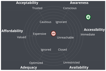 |
| Availability | Supply and demand | |
| Adequacy | Organization | |
| Affordability | Financial and incidental costs | |
| Acceptability | Consumer perception | |
| Awareness | Communication and information |
| Access Dimensions | Definition | Discrete Scale: Levels [1–5] |
|---|---|---|
| Accessibility | Effort |  |
| Access Dimensions | Evaluation Criteria (• Neutral, + Positive, − Negative) | |
|---|---|---|
| Accessibility | Transect Walks | − need to travel to the location of the participatory session − the starting point and ending location are different • transportation facilities depend on the transect location |
| 3D platform | + from anywhere with a smartphone or from home with a computer − not all smartphones can render 3D graphics (a computer is recommended) | |
| Survey | + from anywhere with a smartphone or from home with a computer | |
| Availability | Transect Walks | + no limitation of participants (within an organizational limit) |
| 3D platform | + no limitation in the number of participants − prototype, users may encounter a bug or downtime | |
| Survey | + no limitation in the number of participants + use of a 3rd party survey service, reduce the risk of downtime | |
| Adequacy | Transect Walks | − thematics unknown in advance, chosen by the authorities − 17 sessions of 2 h on weekdays in the evening (sometimes starting at 4 p.m.) |
| 3D platform | + platform accessible 24/7 via an internet connection + free choice to select the point of interest • 3D navigation skills | |
| Survey | + platform accessible 24/7 via an internet connection − non-flexible questions | |
| Affordability | Transect Walks | • event on a weekday may induce organizational fees • no entrance fee |
| 3D platform | − 3D graphics rendering requires a performant smartphone or computer • no entrance fee | |
| Survey | • no entrance fee | |
| Acceptability | Transect Walks | + citizens accustomed to the procedures and to participating + proximity of the authorities |
| 3D platform | + citizens accustomed to the procedures and to participating • written record that can be consulted by all • anonymity if not registered | |
| Survey | + citizens accustomed to the procedures and to participating + anonymity − impersonal − no opportunity to get more information on the consideration of the results | |
| Awareness | Transect Walks | + massive communication campaign + various channels are exploited |
| 3D platform | + massive communication campaign + various channels are exploited | |
| Survey | + massive communication campaign + various channels are exploited | |
| Attractiveness | Transect Walks | − outside, need to walk a couple of kilometers − online registration is needed − complexity of the actors’ exchanges |
| 3D platform | + wow effect of the 3D representation − non-familiarity with the medium • one-way user interaction • no mandatory registration but strongly encouraged | |
| Survey | + no registration + familiarity with the medium − simple survey |
| Access Dimensions | Evaluation Criteria (• Neutral, + Positive, − Negative) |
|---|---|
| Accessibility | − must travel to the location of the participatory session − snowy weather for the event on 1 March • well-connected to the public transportation network • 30 parking spaces |
| Availability | + did not reach the maximum capacity • 5 tables of a maximum of 12 participants |
| Adequacy | + topic selected according to citizens’ concerns − 2 sessions of 3 h on weekdays in the evening |
| Affordability | + snacks and refreshments offered • no entrance fee • event on a weekday may induce organizational fees (childcare, …) |
| Acceptability | + the authorities’ open attitude: consultation + citizens accustomed to the procedures and to participating + proximity of the experts and project managers • context of strong opposition towards the project |
| Awareness | + flyer distributed to all households concerned + some participants are already involved (word-of-mouth) − no social network communication |
| Attractiveness | − online registration is needed • formal setting of the on-site workshop • full immersion increases the cognitive load |
Publisher’s Note: MDPI stays neutral with regard to jurisdictional claims in published maps and institutional affiliations. |
© 2021 by the authors. Licensee MDPI, Basel, Switzerland. This article is an open access article distributed under the terms and conditions of the Creative Commons Attribution (CC BY) license (https://creativecommons.org/licenses/by/4.0/).
Share and Cite
Chassin, T.; Cherqui, A.; Ingensand, J.; Joerin, F. Impact of Digital and Non-Digital Urban Participatory Approaches on Public Access Conditions: An Evaluation Framework. ISPRS Int. J. Geo-Inf. 2021, 10, 563. https://doi.org/10.3390/ijgi10080563
Chassin T, Cherqui A, Ingensand J, Joerin F. Impact of Digital and Non-Digital Urban Participatory Approaches on Public Access Conditions: An Evaluation Framework. ISPRS International Journal of Geo-Information. 2021; 10(8):563. https://doi.org/10.3390/ijgi10080563
Chicago/Turabian StyleChassin, Thibaud, Adeline Cherqui, Jens Ingensand, and Florent Joerin. 2021. "Impact of Digital and Non-Digital Urban Participatory Approaches on Public Access Conditions: An Evaluation Framework" ISPRS International Journal of Geo-Information 10, no. 8: 563. https://doi.org/10.3390/ijgi10080563
APA StyleChassin, T., Cherqui, A., Ingensand, J., & Joerin, F. (2021). Impact of Digital and Non-Digital Urban Participatory Approaches on Public Access Conditions: An Evaluation Framework. ISPRS International Journal of Geo-Information, 10(8), 563. https://doi.org/10.3390/ijgi10080563