Article

The Regional and Local Scale Evolution of the Spatial Structure of High-Speed Railway Networks—A Case Study Focused on Beijing-Tianjin-Hebei Urban Agglomeration

1
College of Applied Arts and Science, Beijing Union University, Beijing 100191, China
2
State Key Laboratory of Resources and Environmental Information System, Institute of Geographic Sciences and Natural Resources Research, Chinese Academy of Sciences, Beijing 100101, China
3
College of Resources and Environment, University of Chinese Academy of Sciences, Beijing 100049, China
4
Key Laboratory of Tibetan Environment Changes and Land Surface Processes, Institute of Tibetan Plateau Research, Chinese Academy of Sciences, Beijing 100101, China
*
Author to whom correspondence should be addressed.
ISPRS Int. J. Geo-Inf. 2021, 10(8), 543; https://doi.org/10.3390/ijgi10080543
Submission received: 22 June 2021 / Revised: 5 August 2021 / Accepted: 10 August 2021 / Published: 12 August 2021

Abstract

:
China has entered an era of rapid high-speed railway (HSR) development and the spatial structure of urban agglomerations will evolve in parallel with the development and evolution of the spatial structure of the HSR network. In this study, we explore how the spatial structure of an HSR network evolves at regional and local scales. Existing research into HSR network structures has mostly been carried out at a regional scale, and has therefore failed to reveal the spatial connections within a city. In this work, we progress the science by exploring it at a local scale. To describe the HSR network more accurately, we use the dwell time to simulate the passenger flow between stations and use the simulated passenger flow as the network weight. We use complex network analysis to investigate the evolution of the network’s spatial structure. Our results present the evolution of station locations, of community structure, and of the locations of connections between stations at a regional scale, and also show how HSR network development within core cities has impacted structures and connectivity at a local scale. These results help us to understand the spatial structure of urban agglomerations and cities, and provide evidence that can be used to optimize the structure of the HSR network within regions and cities.

1. Introduction

The high-speed railway (HSR) has made commuting between cities very convenient and has had a significant impact on economic development, ecology, and land use within cities [1,2,3,4,5]. China attaches great importance to the role of HSR in urban economic development, meanwhile, starting with the opening of the Beijing-Tianjin Inter-city Railway in 2008, has been using large-scale construction of HSR as a vehicle for the revitalization of various local industries. In 2016, China proposed the national “Mid-to-long Term Railway Development Plan”, under which many HSR lines have been planned or constructed, leading to projections that the HSR network will reach 38,000 km in 2025, and that all cities with a population of over 500,000 will be connected by HSR by that year [6]. As the constructed HSR network expands, increasing numbers of cities will join the network and the spatial interaction between cities will evolve. The HSR network is therefore related to the status and function of cities in urban agglomerations, and to the structure of spatial connections between cities. Studying the spatial evolution of an HSR network may be helpful for understanding the evolution of the spatial structure of urban agglomerations, and the function and status of cities within urban agglomerations, and may provide insights useful for optimizing the spatial structure of urban agglomerations and for accelerating their integration.
Research focused on HSR networks has contributed significantly to our understanding of the spatial structure of urban agglomerations; however, existing research focused on regional scales and has neglected the local scale, i.e., the intra-city HSR network has received little attention. Analysis of the evolution of the HSR network spatial structure at the regional scale can help us to understand the spatial structure of urban agglomerations. Meanwhile, research focused on the local scale can provide insights that are useful solving problems associated with commuting and strengthen the connection between different groups within large cities, which is essential to improve the urban living environment. Therefore, we need to build an HSR network based on the stations rather cities. Previous research was usually based on HSR frequency, because the actual passenger flow data are difficult to obtain [7]. Zhang et al. [8] proposed an inter-city HSR passenger flow simulated model; therefore, in order to serve our research, we will explore how to transform the passenger flow simulation model based on inter-city to the situation based on inter-station, which is one of the purposes of this research. Moreover, another purpose of this research is to pay attention to the spatial structure evolution characteristics of the HSR network, including regional and local scales, so that the structural analysis of the HSR network will go deep into the city and compare the development differences of the HSR network structure in different cities. One of the contributions of this research is to explore the passenger flow simulated model between any two HSR stations and apply it to the structure study of the HSR network, which is an innovation in the data and method dimension, and provide method references for other studies that want to simulate passenger flow between HSR stations. Another contribution is that the analysis conclusions of the internal HSR network in a city can intuitively demonstrate the construction process of a HSR network in the city, which has significance for the city in solving internal traffic problems, connecting with urban planning, and optimizing the urban spatial structure. In this work, we first study how to calculate the passenger flow between stations, then build a HSR network based on the simulated passenger flow, and lastly answer such a question: How does the spatial structure of the HSR network evolve at regional and local scales?
Real passenger flow data are difficult to obtain. We chose to use simulated passenger flow data to construct an HSR network for our investigation. This is justified by research that showed that the remaining tickets (unsold tickets) and dwell time (the time spent by a train) for HSR are related to actual passenger flow [9,10], meaning that HSR passenger flow can be inferred from dwell time. In our study, we use simulated HSR passenger flow based on dwell time [8] as a measure of the interaction between nodes, which allows us to construct a more precise HSR network.
The coordinated development of the Beijing-Tianjin-Hebei urban agglomeration is one of China’s three current strategies, which mentions the need to build a modern transportation network system with the Beijing-Tianjin-Hebei as a whole. Therefore, studying the spatial structure of the Beijing-Tianjin-Hebei HSR network is essential to serve the coordinated development strategy at the aspect of transport. This article is based on the Beijing-Tianjin-Hebei urban agglomeration, and the research framework is shown in Figure 1. As mentioned in this framework, we first use the simulated passenger flow calculated from the dwell time recorded at HSR stations to construct an HSR network. The first part is based on regional scale. We analyze the evolution of the regional scale spatial structure of the HSR network from 2014 to 2020, using complex network methods (eigenvector centrality [11], modularity index [12,13], and network connection degree index [9]) respectively to assess the evolution of the status of stations, of community groups (a community group means a group of closely connected stations, which can be used to further analyze the HSR network structure), and of connections between stations. The second part is based on local scale. We then identify core stations within the HSR network and analyze and compare the structure of HSR network within the city where the core station is located, and the complex network methods (average weighted aggregation coefficient [14], average shortest path length [15]) can also be used. In addition, we consider the Beijing-Tianjin-Hebei urban agglomeration to be a regional scale entity, and each core city to be a local scale entity.
The remainder of this article is structured as follows: Section 2 reviews literature focused on HSR networks; Section 3 introduces the research data and complex network methods used in our study; Section 4 presents the evolution of the HSR network spatial structure from 2014 to 2020, and compares features of the different HSR networks in the cities where core stations are located; Section 5 carries out some discussions and proposes directions for future work; and Section 6 presents some conclusions.

2. Literature Review

2.1. Research on Geographic Network

The study of geographic networks is a hot spot in current. For example, Chidubem et al. [16] used the transfer learning paradigm to compare the spatial characteristics of street networks, and Yang et al. [17] used bus service data to study the characteristics of bus operating network. With the development of information technology, the acquisition of social media data are becoming more and more popular. Complex network analysis based on social media data provides a new perspective for urban research. Zhong et al. [18] used mobile signal data to study Tibet’s tourism flow network; Ahn et al. [19] used commuting travel purposes (OD data) data to analyze the regional spatial structure characteristics with the help of degree centrality and eigenvector centrality. Liu et al. [20] used the Baidu Index to analyze the structure of China’s tourism flow network, using methods such as network density, proximity centrality, the core-periphery structure model, and structural holes. The complex network’s study could render some instructions about methods for our research. The HSR network is also a complex network, which can reveal the spatial structure of a region, and the current research on it has yielded fruitful results.

2.2. Research on HSR Networks and Urban Agglomerations

HSR has played an important role in the formation and spatial evolution of urban agglomerations, and much research has been carried out to understand this relationship. For example, studies have used HSR networks to infer urban spatial structures in regions or agglomerations, such as the structure of inter-city connections, the importance of cities, and urban hierarchies. Most of these studies used complex network analysis methods (such as network density, betweenness centrality, hierarchical cluster analysis, degree centrality, closeness centrality), or rank-scale methods, to investigate HSR networks and then to infer urban spatial structures [21,22,23,24,25,26,27,28]. For example, the HSR network in the Yangtze River Delta has significant hierarchical characteristics, and Shanghai and Nanjing are at the top of a city hierarchy [26]. It was found that the inter-city HSR networks in Beijing-Tianjin-Hebei, the Yangtze River Delta and the Pearl River Delta had multiple centers in 2013 [29]. Yang et al. [30] found that the inter-city attention of two cities in the HSR network will reinforce when they have direct links. In addition to constructing, or reinforcing, hierarchies, HSR networks make connections between cities within a city network closer, and more cities then have the potential to grow into sub-centers within the network [21]. It was shown that when a HSR network promotes the multi-centralization of the urban spatial structure, the gap between the urban nodes in the inter-city network that is supported by HSR gradually widens [22]. Research on HSR networks is not limited to its impact on urban spatial structures. The HSR network in China has already had an impact on intercity tourism and economic networks, and on population movement [4,31,32]. For example, it was found that the structure of the tourism network for the Chengdu-Chongqing urban agglomeration evolved to H-shaped and more hierarchical because of the HSR network [31]. It was also found that the HSR network in China is significantly and positively correlated with the economic network, suggesting that the development of the HSR network is important for the spatial flow of economic factors [4]. The development of the HSR network impacts the economic development of cities in different ways [33], including polarization and trickle-down effects, the former one refers to the fact that cities with a higher level of economic development in HSR network continue to accumulate favorable factors, accelerate economic and social development, and continuously widen the gap with other cities, the latter one refers the fact that priority development cities in HSR network benefit poor areas through consumption, employment, etc., and promote their development and prosperity, which may result in uneven development of the urban spatial structure [34,35]. Previous studies tended to investigate HSR networks based on city nodes; however, considering stations as nodes allows comparisons of the function and status of individual stations, which can then be assessed in the context of the degree of development of the HSR network in each city [7,36]. The spatial connections within a city can then be understood, and the commuting network optimized accordingly. In this study, we construct an HSR network based on stations rather than cities, so as to gain a deeper understanding of HSR network. In addition, when constructing an HSR network, previous studies usually selected HSR frequency data as the network weight [37,38,39]. However, passenger flow data may be closer to the real situation. However, these data are difficult to obtain. We simulate the passenger flow between two stations according to the formula proposed by Zhang et al. [8]. The application of this method to the construction of HSR network for subsequent analysis is an improvement to existing research.

2.3. Research on HSR Networks at Multiple Scales

Much research has focused on assessing HSR networks at multiple scales [40,41,42,43,44]. The current body of available research on HSR networks includes studies at national, regional, and urban agglomeration scales. For example, some studies have assessed the structural characteristics of the HSR network in China and in key urban agglomerations, and some have divided China into diverse regions, based on physical geographical divisions. For example, Huang et al. [45] found that the HSR network features have different effects on HSR frequency in national, regional (East, Northeast and Central) scale. Niu et al. [46] found that the closeness centrality and betweenness centrality have different effect on urban land of large, medium and small cities, indicating that HSR network also have heterogeneity impact on urban land at regional scales. Jiao et al. [47] found that economic growth in China’s eastern cities are most sensitive to enhancing their connectivity in HSR network. Multiple scales can be used to measure internal connections within an HSR network in more detail, and to discover the evolution of the status and role of a city at different scales [44,48]. Liu et al. [49] not only analyzed the evolution of the status of Chinese cities in the HSR network, but also analyzed the differences between major urban agglomerations. Most existing research into HSR networks has focused on regional scales (such as national/urban agglomeration/regional (such as the eastern, central and western regions of China)), but it is also necessary that we understand the structure of HSR networks at local scales, such as within a city. By investigating HSR networks at both regional and local scales, we can simultaneously analyze the spatial structure of urban agglomerations and the spatial structure of connections within large cities.

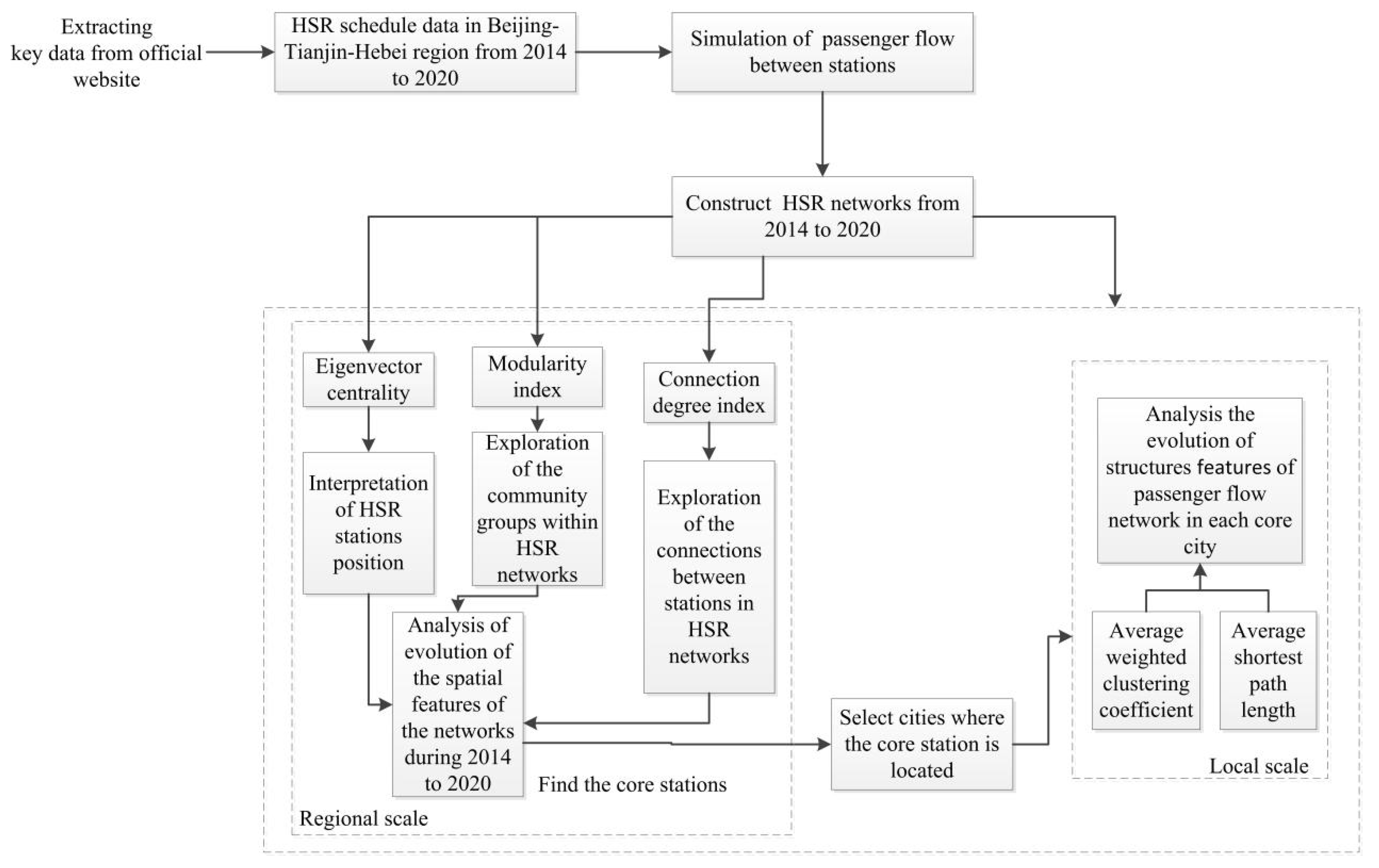
3. Materials and Methods

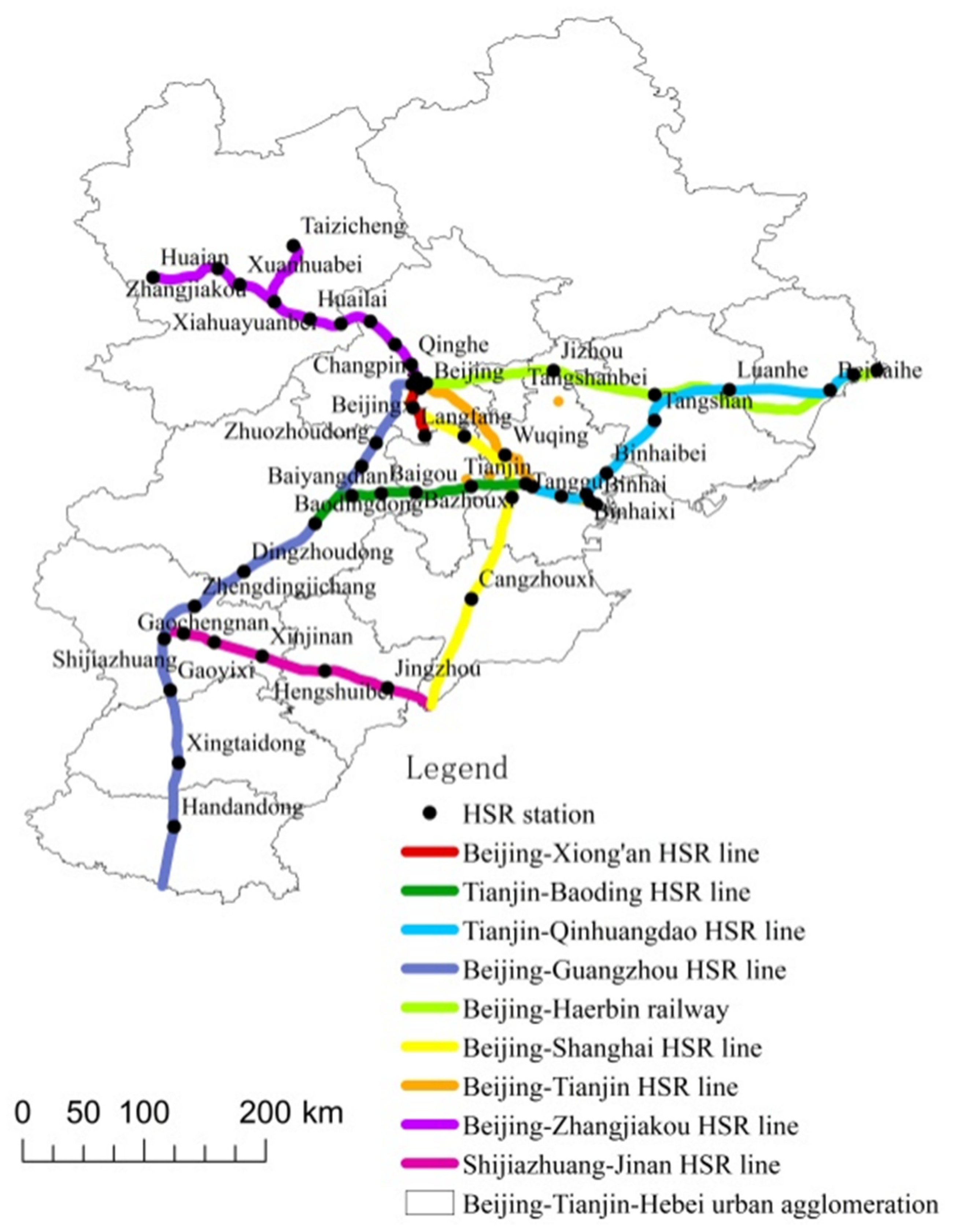
3.1. Study Area and HSR in Beijing-Tianjin-Hebei Urban Agglomeration

The Beijing-Tianjin-Hebei urban agglomeration includes Beijing, Tianjin, and 11 prefecture-level cities in Hebei province: Baoding, Langfang, Tangshan, Shijiazhuang, Handan, Qinhuangdao, Zhangjiakou, Chengde, Cangzhou, Xingtai, and Hengshui. There are 13 cities in the agglomeration in total. The Beijing-Tianjin-Hebei urban agglomeration has a total area of 216,000 square kilometers. As of 2019, the total population is 11.074 million, the GDP is 845.8 billion yuan and the disposable income per capita of Beijing, Tianjin and Hebei is respectively 67,756, 42,404, and 25,665 yuan. It is one of the three major urban agglomerations in China.
In China, any railway line with a speed that exceeds 200 km/h is considered to be an HSR line. As of September 2020, nine HSR lines and 52 stations have opened in our study region, as shown in Figure 2. The nine HSR lines are the Beijing-Shanghai, Beijing-Guangzhou, Shijiazhuang-Jinan, Beijing-Tianjin, Tianjin-Baoding, Tianjin-Qinhuangdao, Beijing-Zhangjiakou and Beijing-Xiongan HSR lines, and the Beijing-Haerbin railway. It is worth noting that the Beijing-Xiongan HSR line was only operational as far as Daxingjichang Station in September 2020. In the Fourteenth Five-Year period, Beijing via Xiong’an to Shangqiu HSR line and Xiong’an to Xinzhou HSR line will be opened. The simulated passenger flow data are based on railway timetable data that were collected between the sites in September 2020 (www.12306.cn). The effects of the COVID-19 pandemic on the national railway network were approaching an end at this time, so the data can be assumed to fully reflect the structural characteristics of the HSR network in the Beijing-Tianjin-Hebei urban agglomeration. Historical data for September 2014 and 2017, obtained from the timetable software for Jipin and Shengming.

3.2. Virtual Passenger Flow Model

Analysis of train operation rules and field investigations show that dwell time depends mainly on the passenger flow on and off the train. Zhang et al. [8] proposed a statistical method to calculate passenger flow from the dwell time of a train in a city, avoiding the influence of other factors, because he believes that the net dwell time is positively correlated with passenger flow on and off the train at stations. The method was verified by comparing actual inter-city passenger flow data (Weibo user’s movement data) [8]. This method has been used to calculate passenger flow on inter-city HSR [8], after analyzing the derivation process, hypothesis and principle of the formula, we found that it considers the city as a whole, and its predicted inter-city HSR passenger flow is also applicable to the situation between stations. Therefore, based on Zhang et al. [8], we changed to a model used to simulate passenger flow between stations. The formula derivation process is as follows.
According to the research [8], the dwell time of HSR has a significant linear relationship with the volume of passenger flow. A dummy parameter ‘r’ is introduced, which refers to the correlation coefficient between passenger volumes and the boarding and alighting time, to simulate the volume of passenger flows. Thus, the volume of passenger flows ‘v’ is dependent on dwell time ‘t’:
v = t   ×   r  
Since there is no dwell time at the beginning and the end station, we set it to half of the longest dwell time of an HSR [8]. In Table 1, ‘vij’ is the number of passengers boarding in station ‘i’ and alighting in station ‘j’. Each row indicates the distribution of alighting for passengers boarding in station ‘i’; each column indicates the distribution of boarding for passengers alighting in station ‘j’. Therefore, the sum of each row (vix) is the number of boarding passengers in station ‘i’, and the sum of each column (vxj) is the number of alighting passengers in station ‘j’.
Zhang et al. [8] hypothesizes that in the course of a day, the boarding and alighting passengers are equivalent in any of the stations, then can be formulated as:
v ix = v xi = v i / 2
v jx = v xj = v j / 2
To evaluate the number of passengers boarding at station ‘i’ and alighting at station ‘j’ (i.e., vij in Table 1), Zhang et al. [8] surveys the probability of boarding in station ‘i’ and alighting in station ‘j’ for all passengers, and he believes that boarding in station ‘i’ and alighting in station ‘j’ are two mutual independent events. According to the rule of the probability of two mutual independent events happening together, the probability of boarding in station ‘i’ and alighting in station ‘j’ can be obtained by multiplying the probability of boarding in station ‘i’ by the probability of alighting in station ‘j’. Likely, we can simulate the number of passengers boarding at station ‘i’ and alighting at station ‘j’ (vi,j) from multiplying the number of boarding passengers at station ‘i’ (vix) by the number of alighting passengers at station ‘j’ (vxj). α is introduced as a dummy parameter describing the relation between vij and vix, vxj.
v ij = α   ×   v ix   ×   v xj
After combining Equations (2)–(4),we can obtain Equation (5):
vij = α × r2 × (ti × tj)/4
For origin or destination stations, the number of boarding or alighting passengers (vox or vxd) is equal to the total passenger volumes (v) [8]. Therefore, the number of passengers of boarding in origin station ‘o’ and alighting in transit station ‘i’ (or boarding in transit station ‘i’ and alighting in destination station ‘d’) is given by:
voj = α × r2 × (to × tj)/2
vid = α × r2 × (ti × td)/2
vod = α × r2 × (to × td)
where ti and tj are the dwell times at stations i and j, respectively. Since our study focuses on the relative passenger flow between stations, the values of α and r do not affect the overall network structure, so the dummy variable α × r2 can be omitted. to and td are dwell time of origin and destination stations.
In summary, compared with other similar models [9,50], this model has its strength. The reason is that it only needs the dwell time of a HSR, which could be acquired at 12306 or other train timetables; however, another model needs the remaining tickets which need real-time tracking and the HSR capacity. In addition, this model uses the characteristics of the positive correlation between the dwell time and the passenger flow, and proposes a prediction model for the passenger flow between different types of stations (such as the origin station and the destination station). Therefore, we believe that this model has the advantages of small amount of calculation, cost saving, and reasonable derivation process.

3.3. Complex Network Analysis

This study assesses the evolution of the spatial structure of the HSR network in Beijing-Tianjin-Hebei at regional and local scales. We use complex network methods to analyze the position of stations in the HSR network, the community structure of the network, the connection potential between stations, and the characteristics of the entire network structure within a city.

3.3.1. Measuring the Position of HSR Stations

We use the eigenvector centrality index to measure the position of HSR stations. Eigenvector centrality is a measure of the importance of a node, derived from the importance of other nodes that are connected with it. A node with high eigenvector centrality is connected to many nodes that also have high degree centrality, and the high degree centrality means one node have direct links with many nodes. The larger this value, the greater the influence of the node on the entire network. The index is calculated using the equation [11,51].
AX = γ X ;   γ i x i = a 1 i x 1 + a 2 i x 2 + + a ni x n   ( i t ) ;   C ( e ) i = γ i
where aij represents the contribution of node i to the status of node j, and A is an n×n adjacency matrix composed of aij; X = (x1, x2, x3 …, xn)T, respectively representing the degree centrality of each node; γ i is the value of eigenvector; C ( e ) i represents the centrality of the eigenvector of node i.

3.3.2. Community Division Based on HSR Stations

The community detection method is the function for dividing entire networks into closely connected sub-networks. Therefore, the community in HSR network means the cluster of nodes with close HSR links rather than spatial distance. We use a modularity index to identify station communities within the HSR network and to determine the network community structure. By definition, nodes within a community are closely connected, while connectivity between communities is relatively weak. A higher modularity index indicates more distinct communities. Network community structures are often unclear [12,13,44].
Q = 1 2 m ij ( A ij k i k j 2 m ) δ ( C i   C j )
where Q represents the degree of modularity; Aij represents the HSR passenger flow from station i to j; ki and kj represent the total passenger flow connected to stations i and j respectively; m is the sum of the weights of the edges in the network; Ci and Cj are the communities allocated by stations i and j respectively, when Ci = Cj, δ(Ci, Cj) = 1, otherwise it is 0.
The modularity index ranges from 0 to 1. A value closer to 1 indicates a more definite community structure. It has been shown that the community structure is clearer when the degree of modularity is greater than 0.3 [52].

3.3.3. Measurement of the Connection Potential between HSR Stations

The network connection degree index represents the strength of the HSR connection between stations [9,53], and we use it here to measure the connection potential between HSR stations.
H ij = f ij / m   ×   L i   ×   L j
L i = t / ( g 1 )   ×   F i / M g
where Hij is the network connection degree index between nodes i and j; fij is the passenger flow between nodes i and j; m is the average passenger flow for the connection paths between all nodes; Li and Lj are the local centrality for nodes i and j, respectively; g is the number of all connected nodes in the HSR network; t is the number of nodes connected to node i; Fi is the passenger flow for node i; Mg is the average passenger flow for all the nodes.

3.3.4. Measurement of the HSR Network Structure

We used the average weighted aggregation coefficient and the average shortest path length to measure the structure of the HSR network. After identifying the core station, we compared the degree of development for the local scale HSR network to that for the HSR network in other cities, in this way, translating our research from regional to local scale.
(1)
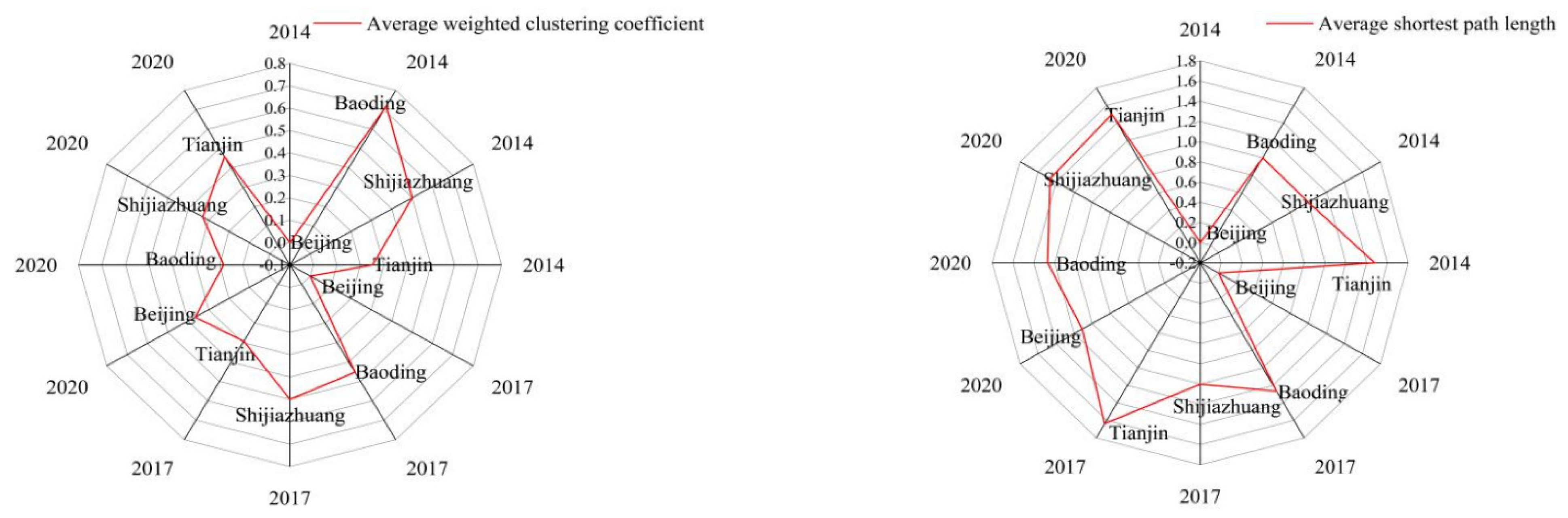
The Average Weighted Aggregation Coefficient
The aggregation coefficient represents the probability that a node is connected to another two nodes, and is a measure of the closeness of the connections between the node and the two other nodes. In a weighted network, the strength of the connection between any one node and the other nodes in the network is different for each node, and so both the topology of the network and the connection strength between nodes must be accounted for when calculating the aggregation coefficient, in contrast to the case for an unweighted network [14,54].
c i = 1 s i ( k i 1 ) j , h N i w ij + w ih 2 a ij a jh a hi
where ki and si are the degree value and weighted degree value of node i in unweighted network and weighted network respectively, j and h are the two nodes adjacent to node i, wij and wih respectively represent the weighted value of edge between node i and node j and node i and node h. If there is a direct connection between the three nodes i, j, and h, then aijajhahi is 1, otherwise it is 0.
The average weighted aggregation coefficient reflects the aggregation degree of the HSR network within a city, and the result is the mean value of the aggregation coefficients of all nodes. We used the average weighted aggregation coefficient to understand relationships between passenger flow at stations within the HSR network in core cities in the Beijing-Tianjin-Hebei urban agglomeration.
(2)
The Average Shortest Path Length
It is defined as the average number of edges that connect the shortest path between two nodes in the HSR network. It reveals the topological structure and shows the accessibility of connections for the node. The equation is taken from [14].
L = [ 2 n ( n + 1 ) ] i j d i j
where dij is the shortest path between node i and node j, and n is the number of nodes in the network.

4. Results

4.1. The Regional Scale HSR Spatial Structure for Beijing-Tian-Hebei

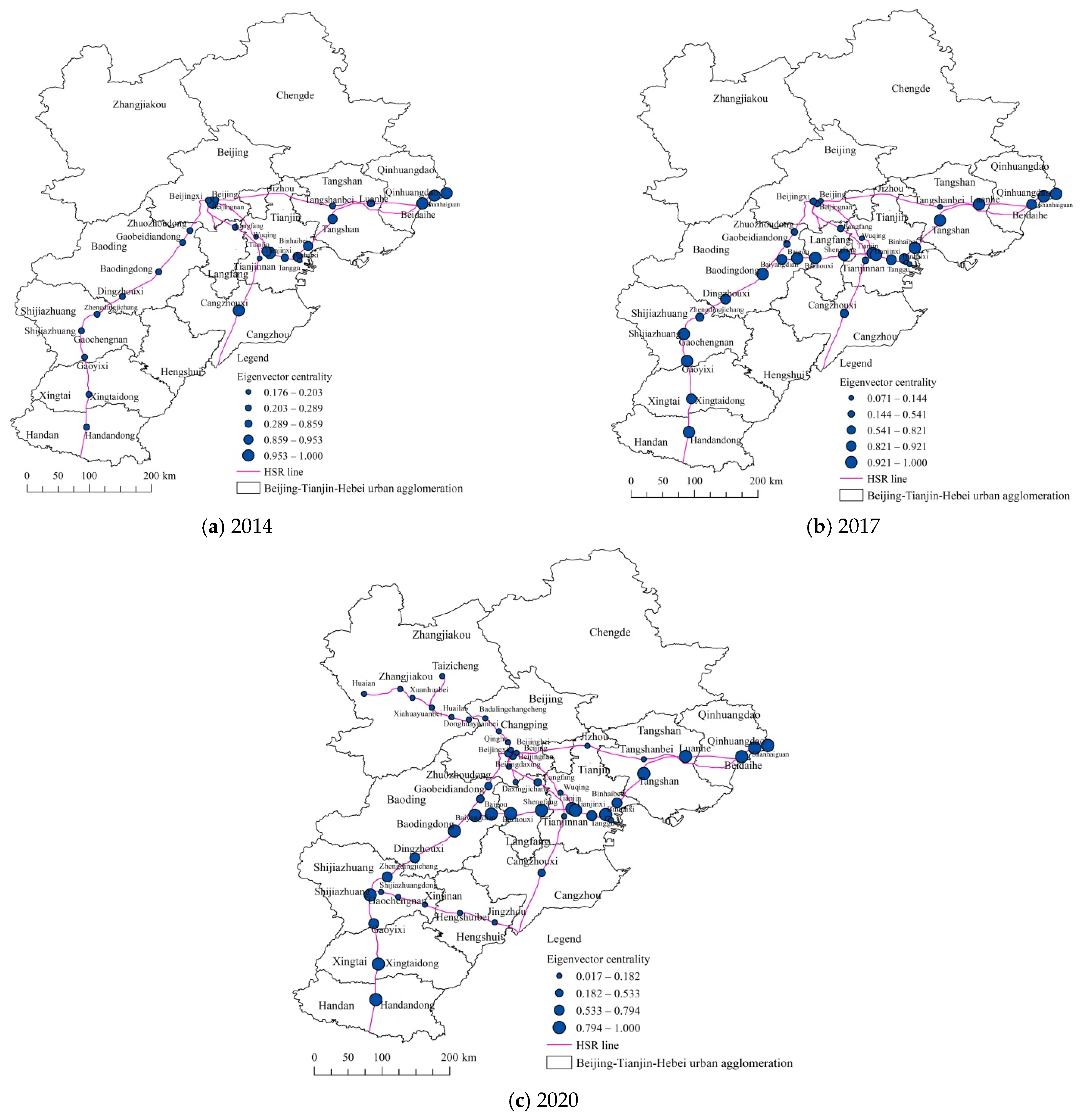
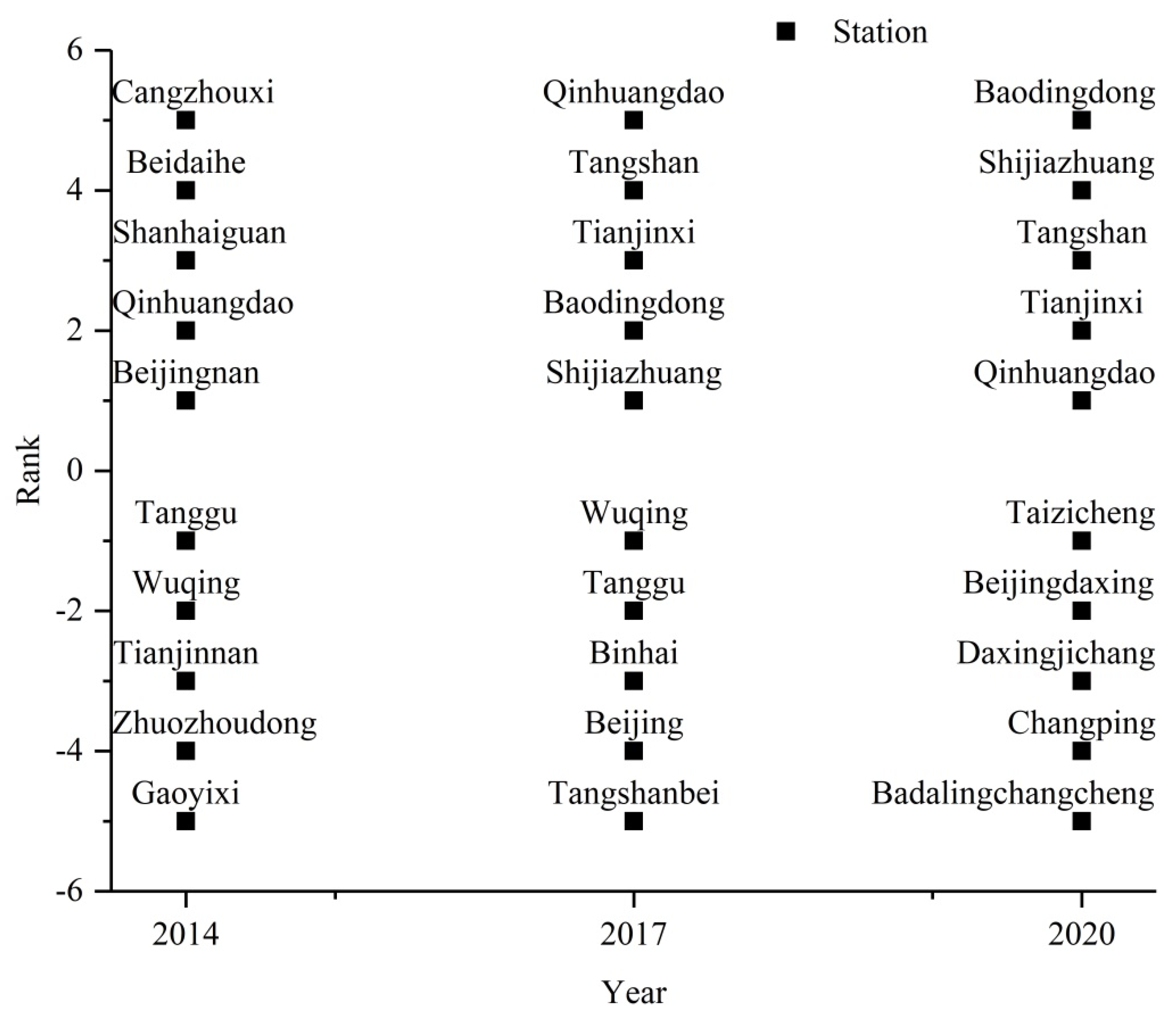
4.1.1. Position of the Stations in the HSR Network

The results and rankings for the eigenvector centrality index are shown in Figure 3 and Figure 4. From 2014 to 2020, the position of HSR stations in Beijing declined, although the decline has been shallower than the trend for denser line networks in the Beijing-Tianjin-Hebei urban agglomeration. This is because there was only one HSR line that operated outside of Beijing in this period, so there were fewer opportunities for HSR stations within Beijing to connect with other HSR stations that had a higher position, and also because the source of passenger flow was relatively limited. The nodes with highest eigenvector centrality are on the Beijing-Guangzhou HSR line and the Tianjin-Qinhuangdao HSR line. Since the Tianjin-Baoding HSR line opened in 2015, the value of stations to the south of Baodingdong Station on the Beijing-Guangzhou HSR line has risen rapidly, indicating that these stations are strongly connected with many nodes that have high eigenvector centrality or a higher position. The Tianjin-Baoding HSR line connects the Tianjin-Qinhuangdao HSR line and the Beijing-Guangzhou HSR line, therefore, the opening of the line connected Handandong and Qinhuangdao, creating the first regional backbone line and a golden corridor within the Beijing-Tianjin-Hebei urban agglomeration. The HSR stations on this corridor are closely connected, and Shijiazhuang, Qinhuangdao, and Tianjinxi stations have a higher position since the opening. The eigenvector centrality for the stations on the corridor is relatively high after 2017. Inspection of the station rankings shows that Qinhuangdao Station has always been in the top five, and the stations in the northeastern coastal areas appear frequently in the top five. With the opening of the Tianjin-Baoding and Shijiazhuang-Jinan HSR lines, the hub roles of Baodingdong, Tianjinxi, and Shijiazhuang stations have been strengthened. As a result, they have remained fairly consistently in the top five since 2017. These findings should be considered and used to optimize the line network structure as part of the accelerated construction of the Xiong’an New Area and the integrated development of the Beijing-Tianjin-Hebei urban agglomeration, so as to broaden mutual connections between the stations in Beijing and the Xiong’an New Area and other regions.

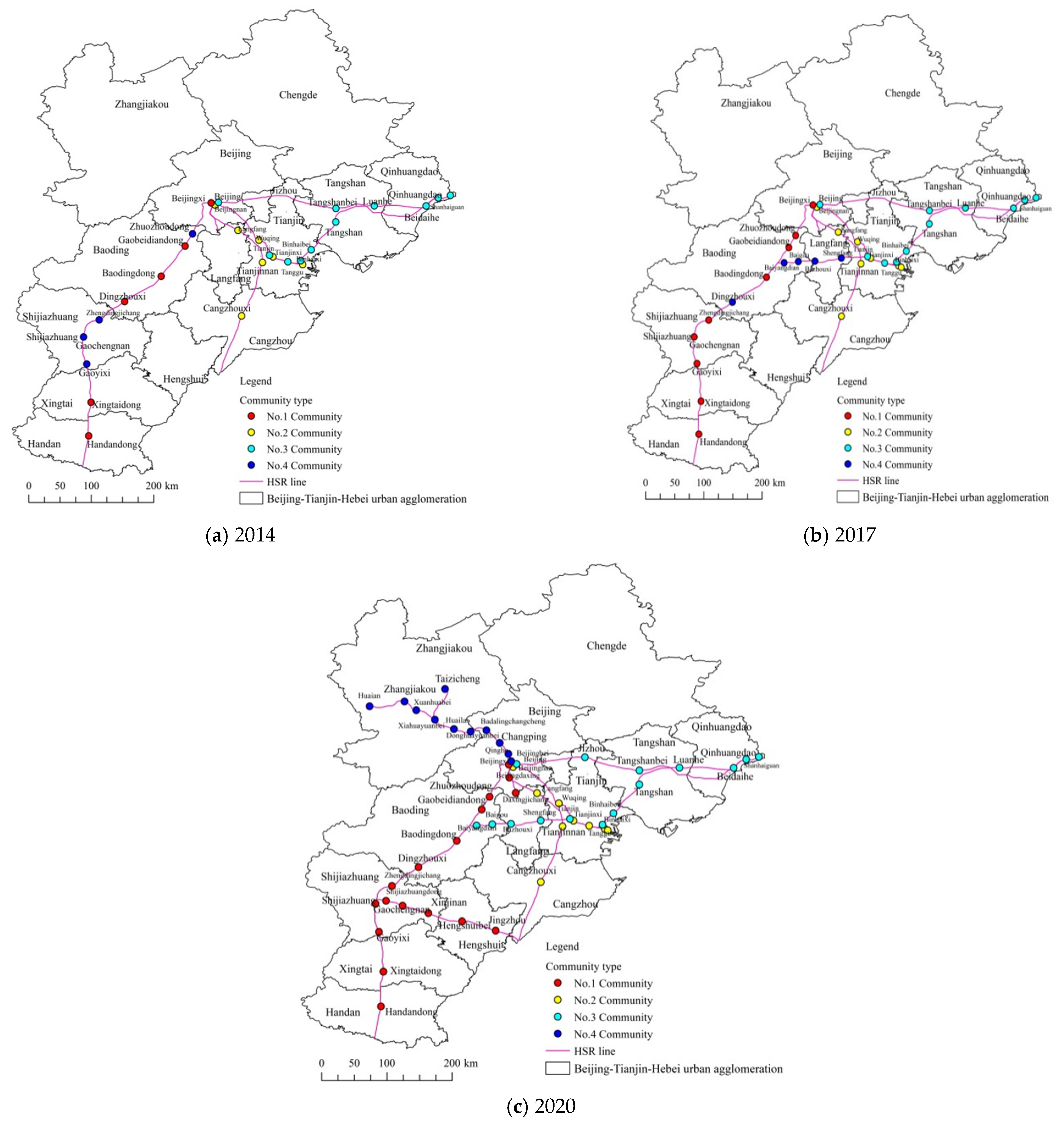
4.1.2. Community Structure for the HSR Network

The community in HSR network means the cluster of nodes with close HSR connections rather than spatial distance. This section uses the community discovery method to divide the stations in the HSR network into multiple community groups to discover closely connected station groups and study the evolution of the community structure. Stations in the HSR network were divided into four communities based on the weight of the simulated passenger flow between HSR stations in the Beijing-Tianjin-Hebei urban agglomeration (Figure 5). The modularity indexes for 2014 and 2017 and 2020 are 0.297, 0.297 and 0.389, respectively. In 2020, the community structure of the entire HSR network is more significant than at earlier times in the study period, with a higher modularity index that reflects the “grouping effect” of the network on stations, and shows that close connections between the stations have become more significant. Figure 5 shows that the Handandong-Qinhuangdao line corridor was officially formed when the Tianjin-Baoding HSR line opened in 2015, breaking the original community groups on Beijing-Guangzhou HSR line while other community groupings persisted from 2014 to 2017. By 2020, community groupings follow pairs of connected lines, for example, Tianjin-Qinhuangdao HSR line and Beijing-Haerbin Railway line, Shijiazhuang-Jinan and Beijing-Guangzhou HSR lines, and Beijing-Shanghai HSR line and Beijing-Tianjin HSR line. The linear distribution replaces the formerly irregular surface distribution of community groupings. This shows that connections between some HSR lines in Beijing-Tianjin-Hebei are extremely weak, such as the Beijing-Guangzhou and the Beijing-Shanghai HSR lines. In general, the HSR network community structure in Beijing-Tianjin-Hebei reflected a regular linear distribution from 2014 to 2020, and there remains a need for some HSR lines to establish connections, even if they are not directly connected.

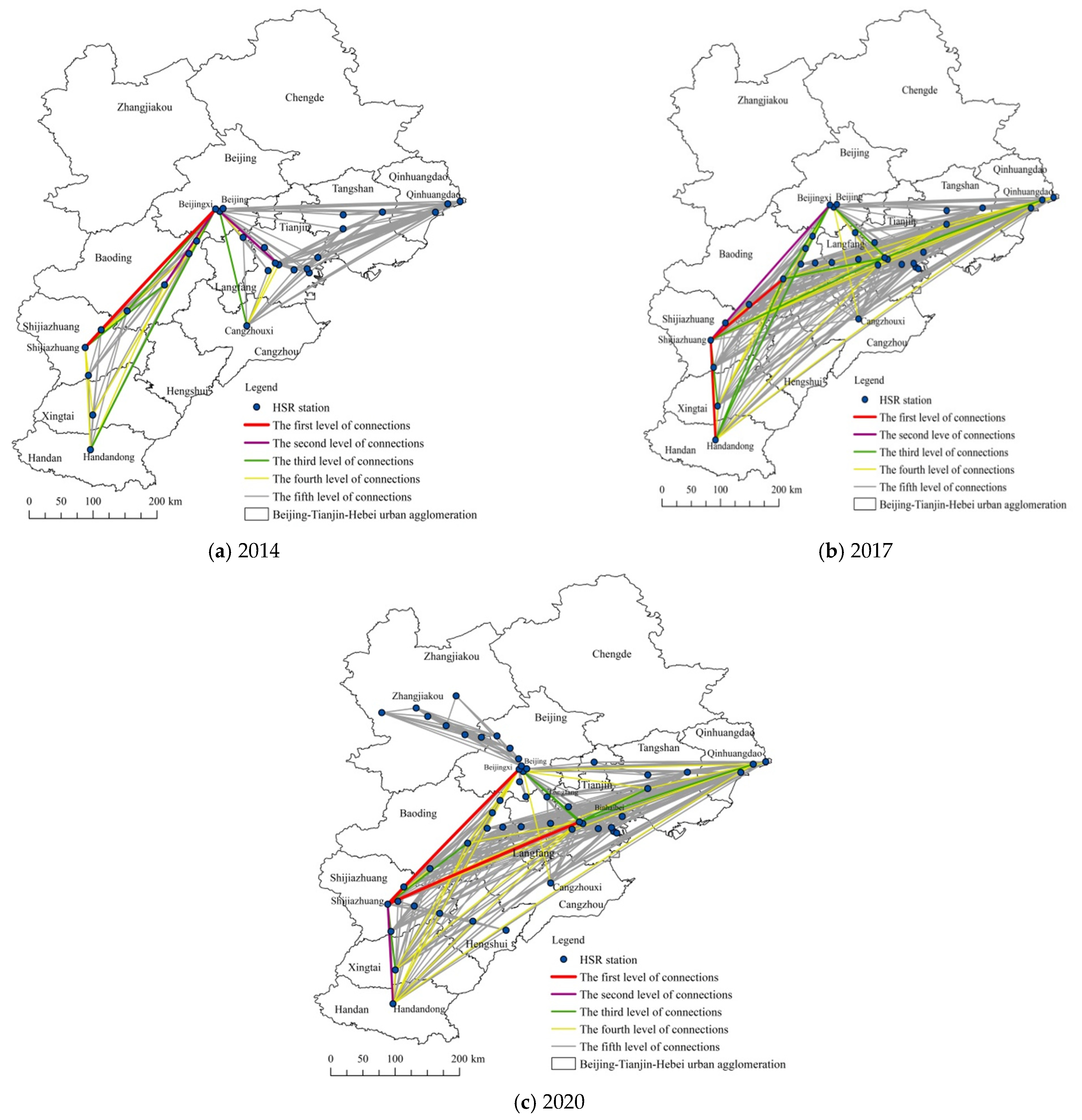
4.1.3. Spatial Structure of the Connection Potential for HSR Stations

We calculated the degree of network connection between HSR stations within the Beijing-Tianjin-Hebei urban agglomeration and analyzed the spatial characteristics of connections between the stations at regional scale, classifying them according to the principle of small differences within groups and large differences between groups. The calculated degrees of connection between stations were divided into five levels, and the degree of network connection (from large to small) corresponds to levels one to five (Figure 6).
In the presented development and evolution of connections between stations from 2014 to 2020, the first level represents the station pair with most closely connected passenger flow in the Beijing-Tianjin-Hebei urban agglomeration. As the HSR network continued to develop through the study period, the most closely connected station pairs all included Beijingxi Station, Shijiazhuang Station and Tianjinxi Station, reflecting the status of Beijing, Tianjin, and Shijiazhuang as the cities with the highest level of development in the Beijing-Tianjin-Hebei urban agglomeration. Shijiazhuang Station remained at level one throughout the study period, and has close passenger flow connections with Baodingdong and Handandong stations, indicating that the Handandong-Qinhuangdao corridor makes Shijiazhuang Station the highest level hub in the Beijing-Tianjin-Hebei urban agglomeration, and showing that Shijiazhuang Station is a core station.
The stations with the second level have evolved from being led by Beijing to being led by Shijiazhuang. Shijiazhuang Station has become the core station that controls the first two levels of connectivity. In 2020, this level only includes passenger flow between Shijiazhuang and Handandong stations, which is higher than the HSR passenger flow between Beijing and Tianjin, indicating that Shijiazhuang and Handan, as a city pair, may form a new group with strong spatial interactions in the Beijing-Tianjin-Hebei urban agglomeration. Combining the first two levels, we found that the top-level connections show the HSR inter-city connection structure with Shijiazhuang as the core.
At the third level, more cities are included. Due to the opening of the Tianjin-Baoding HSR line, the Handandong-Qinhuangdao corridor gradually matured as the backbone of the network at this level, driving a gradual increase in the intensity of external connections between major stations along the corridor in secondary cities, such as Tangshan and Baoding. Simultaneously, the level of connection among some stations pairs declined, indicating that higher hierarchical connections may gradually decrease as the HSR network structure becomes optimized, promoting the emergence of a more balanced HSR network system in the Beijing-Tianjin-Hebei urban agglomeration.
At the fourth level, a triangular inter-city connection between Handan, Beijing and Qinhuangdao began in 2017 and persisted through the study period. Except for the HSR connection between these three cities, the connections of HSR stations at this level is affected by spatial proximity, as many stations are separated by relatively short distances. HSR lines are constructed between nearby cities to facilitate short-distance commuting between them. At this level and below, the station pairs with stronger connections are county-level stations.
More connections fall into the fifth level than any other level, and the degree of connection between two HSR stations at this level is the lowest in the HSR network. Most connections at this level are between lower-level (country-level) stations, or between low-level and high-level stations (prefecture city-level). Stations that have a low connectivity with other cities in the network also tend to appear at this level, such as Hengshuibei and Cangzhouxi stations, which lack direct links with the major cities to their north and west, respectively. Direct HSR links between such stations, and between other stations in some big cities such as Beijing and Shijiazhuang, are urgently needed.
In summary, the HSR network in the Beijing-Tianjin-Hebei urban agglomeration has evolved so that the connection levels between stations make Shijiazhuang, Beijingxi, and Tianjinxi stations the main cores for the network, Handandong and Qinhuangdao stations are secondary cores, and other stations are subordinate stations. A trapezoidal area of stations with strong connectivity has formed, bounded by Beijing-Qinhuangdao-Shijiazhuang-Handan, which is the area with the highest level of economic development and population mobility in the Beijing-Tianjin-Hebei urban agglomeration. The connection level for most HSR stations in the Beijing-Tianjin-Hebei urban agglomeration has declined, and connections between stations have evolved to become more spatially balanced.

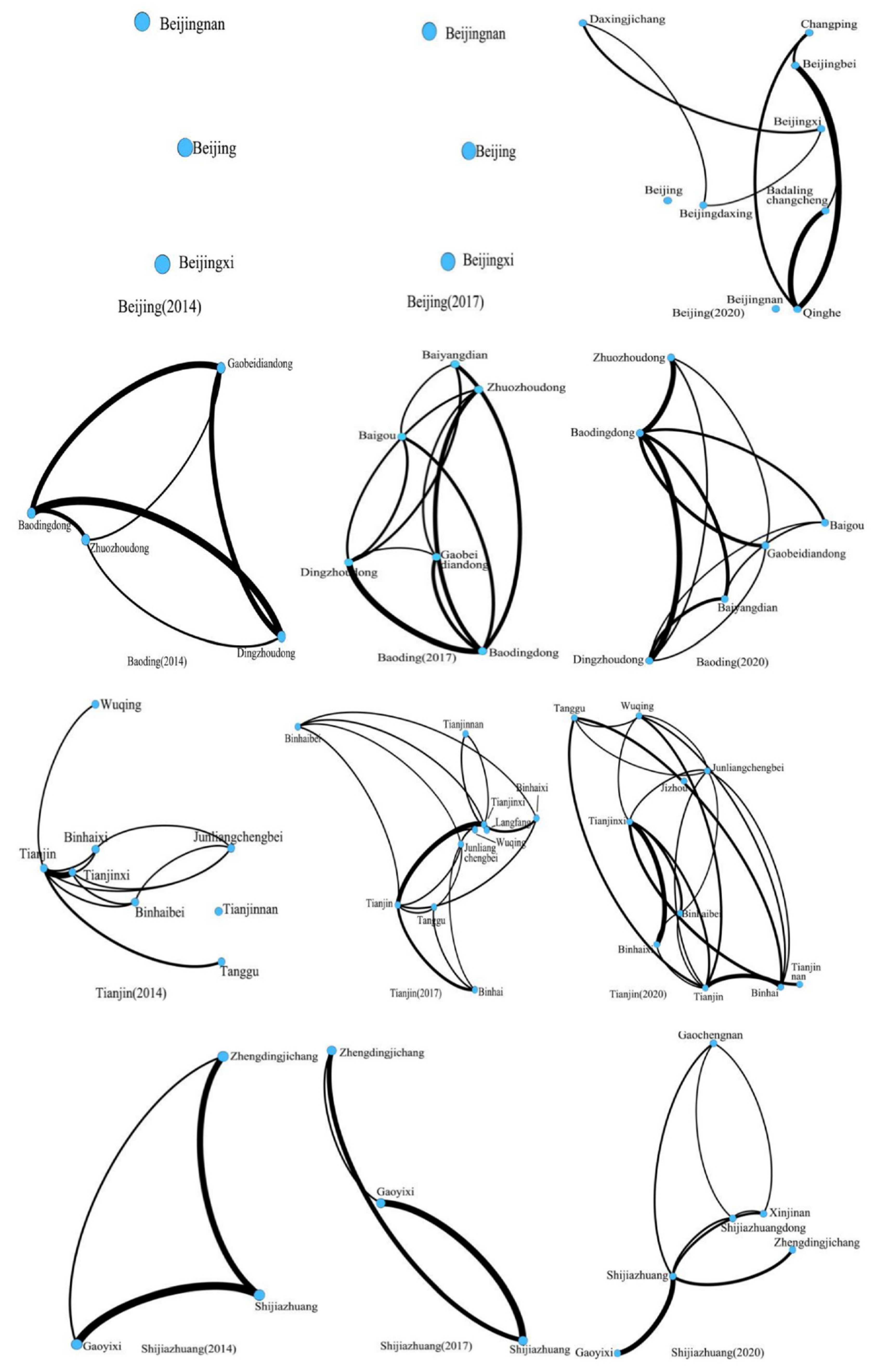
4.2. The Local Scale HSR Network Structure for Cities That Include Core Stations

In the preceding sections, we explored the positions and community structures for the stations, and the structure of connections between them. In this section, we progress our study from a regional to a local scale. We first identify the core stations, then we investigate, at a local scale, the HSR networks of core prefecture-level cities where the core stations are located.
The core-edge structure recognition method is used to identify core stations in the HSR network for the years covered by the study. In general, there are no big changes through the study period. By 2020, there are five stations are considered to be core stations: Shijiazhuang, Baodingdong, Tianjinxi, Handandong and Beijingxi stations. Handandong Station has always been the only one HSR station in Handan. Handan does not yet have the characteristics of an HSR network. Therefore, the cities where the remaining four HSR stations are located are selected for analysis of development differences that were influenced by the HSR network structure from 2014 to 2020. The aim of this part of our study is to understand the effects of HSR network structure for core cities at a local scale.
Figure 7 shows the HSR network in Beijing, Baoding, Tianjin and Shijiazhuang, and in the graph, the blue point shows an HSR station, and the black line shows simulated HSR passenger flow (the thicker the line, the greater the passenger flow). From this figure, according to the form of the complex network (the connection between stations and the strength of the connection), we can visually compare the structural differences of the HSR networks in the four cities. As shown in Figure 7, as the study period progressed, the number of nodes participating in the HSR network increased for all four cities, indicating the participation of more stations in the HSR system within the city. This is particularly evident for Beijing, which evolved from having three HSR stations at the start of the study period to becoming a relatively mature HSR network by the end of the period.
Comparing the average weighted clustering coefficients, Figure 8 (left) shows those stations of HSR network in Tianjin that have the closest passenger flow connection, and the value of Tianjin ranked first for this in 2020. Connections between stations in the HSR network in Baoding ranked lowest in 2020. This is because the clustering coefficient takes into account the number of passenger flows between stations, although the HSR network in Baoding is relatively dense and perfect in terms of topology structure, passenger flow between some stations is low. The reason for this is that the HSR network in the Beijing-Tianjin-Hebei urban agglomeration is becoming increasingly optimized, and the HSR passenger flow from Baoding tends to be flow to higher-level cities rather than to other areas in Baoding. The HSR passenger flow between intra-city stations in Baoding has therefore decreased, which is closely related to the city positioning of Baoding as a labor exporter. This may change in future, when the Xiong’an New Area in Baoding is completed, and the spatial structure of Baoding’s HSR network should then be adjusted.
Figure 8 (right) shows that the average shortest path length between stations in Tianjin has always resulted in the highest position for these stations, and Baoding, Shijiazhuang also hold a higher position in 2020. This shows that many stations in these three cities are not directly connected as the construction of HSR lines, or we can say the development of HSR network is not mature enough at local scale. For example, the value of Shijiazhuang increases significantly from 2014 to 2020, the number of HSR lines is gradually increasing, but there is no HSR connection between some stations on different lines. This can also be seen from Figure 7 (comparison with Tianjin and Baoding). This indicates that additional stations in key areas should be considered to strengthen the establishment of HSR connections with stations in other regions.
As more HSR lines are developed for large cities such as Shijiazhuang, Tianjin, and Beijing, consideration should be given to the spatial distribution of the intensity of passenger flow between stations. In areas that form industrial clusters, large-scale industrial areas and residential areas within megacities can participate in the HSR station network, which can help to alleviate imbalances between work and housing. The Xiong’an New Area must strengthen its already strong connection with the first level cities of Beijing, Tianjin and Shijiazhuang, and also needs to improve its HSR links with surrounding counties and cities, so as to provide opportunities for the development of Baoding. Therefore, one of the significant aspects of the results is to understand and track the current construction process of HSR networks in big cities, and to compare the HSR networks of different cities with the analysis of simulated passenger flow data and the topological characteristics. Ultimately, it will help solve urban travel problems, adjust the regional travel structure, and better connect different functional areas within the city.
Although Beijingxi Station has always been in a high-level/core position in the HSR network at a regional level, it plays only a marginal role in the local scale HSR network in Beijing, because it is not integrated into the urban HSR network. In contrast, Gaobeidiandong Station has a marginal role at a regional level, but becomes a core station with a relatively high-position and hub-function for the local scale HSR network in Baoding. This demonstrates the differences in the status, function, and degree of external relations for the same station at regional and local scales. Understanding these characteristics will help us to fully understand the role of an HSR station in a city and in the wider region. These insights will also help to guide decision-making for adjustments to regional HSR networks, and for addressing commuting problems in some big cities. Recognizing the different positions of the same station on the regional and local scales, being able to understand the spatial connection level of a station with the interior of the city and other cities, is helpful to assist the detailed planning of the station area, especially the industrial planning and the planning of connecting traffic. Taking into consideration the two mid-latitudes of the station’s external and internal connections, it is possible to comprehensively design the station area plan.

5. Discussion

This study discusses the structural evolution of the HSR network in the Beijing-Tianjin-Hebei urban agglomeration, and in four core cities. However, there are some shortcomings existing in results.
The first is that we use the eigenvector centrality to obtain the position of each station in the HSR network, but this indicator does not consider the weight of the passenger flow between the stations, and analyzes the position of the station from the network topology, i.e., the topological connection between the station and other stations. If we consider the weight, the result may change significantly. The average shortest path does not also consider the size of the passenger flow between stations. If the weight is considered, the analysis results of the urban HSR network will be more profound and comprehensive.
The second is to compare the results of HSR networks of different cities. Our results may give the characteristics of the four cities’ HSR networks from a weighted and unweighted perspective to a certain extent. However, there are still some problems, such as the large difference in the number of stations in different cities and their connection conditions, which may affect the comparability of the results, and comparisons can be made when the HSR networks of various cities become more mature, and then more reasonable results may be obtained.
Compared with the studies of [7,24], we not only analyzed the HSR network structure from the regional scale (urban agglomeration), but also compared the characteristics of the HSR network of the four cities in the interior of the city, transferring the research scale to the local level. Compared with the research of [24,47], we are based on the formula of simulating passenger flow when constructing the HSR network, instead of using the HSR frequency, the analysis of the characterization of HSR network may be more accurate. Compared with the research of [47,55], we lack the consideration of passenger flow between nodes for the status measurement of HSR network nodes. This is where we need to improve in the future.
Next, we will discuss the region and the model used to simulate passenger flow.
First, this research only considers the HSR network in Beijing-Tianjin-Hebei, and lacks any comparison with other large-scale urban agglomerations in China. In future, we should explore and compare differences between HSR network structures in different urban agglomerations, for example, considering community structure, station position or station connection levels. Second, the equation used to calculate HSR passenger flow may not be accurate, as there are several factors that the method does not account for, such as the passenger capacity of each train. It is relatively straightforward to ignore differences between different lines and rely only on the dwell time calculation, as the method we have followed here does. However, there are significant differences between the levels and the number of passengers that are carried on different lines. Future work should consider improvements to how passenger flow is calculated. In addition, due to the lack of historical data and real intercity mobile data that can characterize urban flow, and some public data sources such as Baidu migration data cannot be used for verification, we cannot verify the accuracy of the simulated passenger flow calculation formula such as in [8], but [8] verified the accuracy of the formula in the Yangtze River Delta urban agglomeration. In addition, the method approximating actual flows in railway networks permits practical applications in simulating flows of railway passengers in other cases [8]. Therefore, the method applied in Beijing-Tianjin-Hebei urban agglomeration is also rational and reasonable. Although at present, only indirect verification can be carried out based on the existing data, and there are errors, this indirect verification is better than not being able to perform direct verification because there is no data.
Lastly, we want to give some policy implications for transportation agencies and practitioners. At the regional scale, with the increasing maturity of the HSR network, the HSR links between different cities within the urban agglomeration should be taken seriously. The evolution of strong and weak spatial connections within the urban agglomeration is directly reflected in our analysis, and this means that spatial connections between cities can be adjusted according to current regional economic development, so as to optimize the spatial structure of the urban agglomeration in the context of the HSR network. The HSR network could be viewed as a tool to adjust the spatial structure of urban agglomerations and to boost regional economic development. Therefore, they should use real passenger flows to construct HSR network, use indicators based on HSR flows to analyze station status and the strength of connections between stations, and compare the HSR network structure with the planning of regional traffic and other elements, and continuously improve the HSR service system. At the local scale, they could use real passenger flow data to monitor and adjust the city’s internal HSR network, make suggestions for future line selection based on regional actuals and planning drafts, and address the city’s traffic problems. For example, Beijing’s traffic problems may be relieved by the construction of an HSR network. We found that HSR stations in Beijing were weakly connected to each other, so it may be wise to plan an HSR network for some important areas in Beijing, for example, to link a huge residential area and an industrial park. Once the HSR connections are constructed, the quick and convenient travel that they facilitate could create strong connections between critical areas in Beijing and relieve commuting pressure.
The HSR network plays an important role in the evolution of the spatial structure of an urban agglomeration. Therefore, we can infer the evolution of the spatial structure of urban agglomerations through analysis of the evolution of the HSR network. With the continuous adjustment and improvement of the HSR network in the Beijing-Tianjin-Hebei urban agglomeration, Baoding, Tianjin, and Shijiazhuang stations have evolved into core stations, and function as hubs for the entire network. The structure of spatial connections within the Beijing-Tianjin-Hebei urban agglomeration has evolved to become more balanced.
The connectivity between HSR stations in some cities needs to be improved. The HSR networks in Tianjin and Baoding are relatively complete, and the structures are relatively stable. However, after taking into account the passenger flow between stations, we found that HSR connections between stations in Baoding need to be improved. This is particularly important for the planning and construction of the Xiong’an New Area, the main body of which is located in Baoding. Other counties within Baoding should establish strong HSR links with the Xiong’an New Area. Our findings also show that the role and significance of the same station is different for localscale and regionalscale HSR networks. This work therefore provides a clearer understanding of the role of the external and internal relations between the station and the wider HSR network system at different scales, and may constitute a useful reference for decision-makers when considering the development of a station area.

6. Conclusions

This study used complex network research methods to measure the structural evolution of the HSR network in the Beijing-Tianjin-Hebei urban agglomeration from 2014 to 2020 at regional and local scales. HSR station position, network community structure, the strength of connections between stations at a regional scale, and the structure of local scale HSR networks within core cities were studied. We did not use HSR frequency data, but calculated the HSR passenger flow between any two stations. Our conclusions are presented below.
At first, stations with high eigenvector centrality were concentrated on the Beijing-Guangzhou and Tianjin-Qinhuangdao HSR line. In time, as the network evolved, these become more concentrated along the Handandong-Qinhuangdao linear corridor. The position of stations along the northeast coast was relatively high throughout the study period, while some stations around Beijing had lower eigenvector centrality indices, the reason may be that the limited directions available for HSR operation make the position of these stations persistently weak.
The original community groups on the Beijing-Guangzhou HSR line broke up with the opening of Tianjin-Baoding HSR line, while other communities persisted from 2014 to 2017. The community structure of the network became more significant from 2014 to 2020, and tended to form a linear distribution.
We explored the hierarchical characteristics of connections between stations in the HSR network at regional scale. The HSR connection between stations in the Beijing-Tianjin-Hebei urban agglomeration was divided into five levels. We found that the connections between stations have evolved to become more spatially balanced in the Beijing-Tianjin-Hebei urban agglomeration.
After our regional scale analysis, we conducted our study to at local scale. The results show that the weighted clustering coefficient for the HSR network in Tianjin ranked first in 2020. In contrast, Baoding had dropped to the lowest ranking by 2020. This means the HSR connections between stations in Baoding is relatively weak even though Baoding has a relatively complete HSR network, indicating that the complexity of the network topology does not fully reflect the characteristics of the city’s internal HSR network when weighted passenger flow intensity is considered. The average shortest path lengths for the HSR networks in Baoding, Tianjin, and Shijiazhuang are relatively high, which means that although there are many stations in these cities, some of them do not have direct HSR connections.

Author Contributions

Conceptualization, Dan He, Tao Pei and Jing Zhou; Data curation, Zixuan Chen; Formal analysis, Dan He and Jing Zhou; Funding acquisition, Dan He and Tao Pei; Investigation, Zixuan Chen and Jing Zhou; Methodology, Dan He and Jing Zhou; Project administration, Dan He, Tao Pei and Jing Zhou; Resources, Tao Pei; Software, Zixuan Chen; Supervision, Dan He and Tao Pei; Validation, Zixuan Chen; Visualization, Zixuan Chen; Writing—original draft, Zixuan Chen; Writing—review & editing, Dan He, Tao Pei and Jing Zhou. All authors have read and agreed to the published version of the manuscript.

Funding

This research was jointly supported by Beijing Social Science Fund (No. 19JDGLA006), and the Distinguished Professor Project of Beijing Union University, and A grant from State Key Laboratory of Resources and Environmental Information System, and Premium Funding Project for Academic Human Resources Development in Beijing Union University (No. BPHR2017CZ01).

Data Availability Statement

The simulated passenger flow data are based on railway timetable data that were collected between the sites in September 2020 (www.12306.cn). Historical data for September 2014 and 2017, obtained from the timetable software for Jipin and Shengming, was also used in our study.

Acknowledgments

The authors kindly thank the anonymous referees and the editor, who were extraordinarily helpful and generous with their comments and insights on the earlier draft of our paper.

Conflicts of Interest

The authors declare no conflict of interest.

References

  1. Wang, S.J.; Wang, J.Y.; Liu, X.P. How do urban spatial structures evolution in the HSR era? Case study of Yangtze River Delta, China. Habitat Int. 2019, 93, 102051. [Google Scholar] [CrossRef]
  2. Mu, B.; Mayer, A.L.; He, R.Z.; Tian, G.H. Land use dynamics and policy implications in central china: A case study of Zhengzhou. Cities 2016, 58, 39–49. [Google Scholar] [CrossRef]
  3. Cornet, Y.; Dudley, G.; Banister, D. High Speed Rail: Implications for carbon emissions and biodiversity. Case Stud. Transp. Policy 2018, 6, 376–390. [Google Scholar] [CrossRef] [Green Version]
  4. Guo, Y.; Li, B.; Han, Y.L. Dynamic network coupling between HSR development and urban growth in emerging economies: Evidence from China. Cities 2020, 105, 102845. [Google Scholar] [CrossRef]
  5. Liang, Y.T.; Zhou, K.Y.; Li, X.; Zhou, Z.K.; Sun, W.; Zeng, J.Q. Effectiveness of high-speed railway on regional economic growth for less developed areas. J. Transp. Geogr. 2020, 82, 102621. [Google Scholar] [CrossRef]
  6. Wang, L.; Duan, X.J. High-speed rail network development and winner and loser cities in megaregions: The case study of Yangtze River Delta, China. Cities 2018, 83, 71–82. [Google Scholar] [CrossRef] [Green Version]
  7. Wei, S.; Jiao, J.J.; Wang, L.; Xu, L. Evolving Characteristics of HSRway Network Structure in Yangtze River Delta, China: The Perspective of Passenger Flows. Appl. Spat. Anal. Policy 2020, 13, 925–943. [Google Scholar] [CrossRef]
  8. Zhang, W.Y.; Derudder, B.; Wang, J.H.; Witlox, F. Approximating actual flows in physical infrastructure networks: The case of the Yangtze River Delta high-speed railway network. Bull. Geogr. Socio-Econ. Ser. 2016, 31, 145–160. [Google Scholar] [CrossRef] [Green Version]
  9. Li, T.; Zhang, W.Y.; Cao, X.S.; Wang, L.; Zhang, L. Analyzing intercity railways network in the Pearl River Delta: A comparative study based on connections, capacity and actual flow. Geogr. Res. 2019, 38, 2730–2744. [Google Scholar]
  10. Wei, S.; Yuan, J.F.; Xu, J.G.; Jiang, H.B.; Jiang, J.L.; Ma, H.T. Analysis on Space-time Distribution Characteristics of Passenger Flow along Beijing-Shanghai HSR way Stations. Areal Res. Dev. 2018, 37, 54–57. [Google Scholar]
  11. Zhu, X.H.; Peng, T.; Chen, J.Y. Impact of strategic and critical metals trade network characteristics on the upgrading of industrial stuctures. Resour. Sci. 2020, 42, 1489–1503. [Google Scholar]
  12. Newman, M.E. Analysis of weighted networks. Phys. Rev. E 2004, 70, 056131. [Google Scholar] [CrossRef] [Green Version]
  13. Blondel, V.D.; Guillaume, J.L.; Lambiotte, R.; Lefebvre, E. Fast unfolding of communities in large networks. J. Stat. Mech. Theory Exp. 2008, 10, P10008. [Google Scholar] [CrossRef] [Green Version]
  14. Barrat, A.; Barthelemy, M.; Vespignani, A. Modeling the evolution of weighted networks. Phys. Rev. E 2004, 70, 066149. [Google Scholar] [CrossRef] [PubMed] [Green Version]
  15. Liu, S.Z.; Han, Z.L.; Guo, J.K. The Impact of High Speed Railway on Urban Network Structure in Northeast China. Sci. Geogr. Sin. 2020, 40, 270–279. [Google Scholar]
  16. Chidubem, I.; Gavin, M. A Transfer Learning Paradigm for Spatial Networks. In Proceedings of the 34th ACM/SIGAPP Symposium on Applied Computing, Limassol, Cyprus, 8–12 April 2019; Association for Computing Machinery: Limassol, Cyprus, 2019; pp. 659–666. [Google Scholar] [CrossRef]
  17. Yang, X.P.; Lu, S.W.; Zhao, W.F.; Zhao, Z.W. Exploring the Characteristics of an Intra-Urban Bus Service Network: A Case Study of Shenzhen, China. ISPRS Int. J. Geo-Inf. 2019, 8, 486. [Google Scholar] [CrossRef] [Green Version]
  18. Zhong, L.N.; Sun, S.; Law, R.; Yang, L.Y. Investigate Tourist Behavior through Mobile Signal: Tourist Flow Pattern Exploration in Tibet. Sustainability 2020, 12, 9125. [Google Scholar] [CrossRef]
  19. Ahn, J.; Seo, D.; Kwon, Y.-S. Impact of Innovation City Projects on National Balanced Development in South Korea: Identifying Regional Network and Centrality. ISPRS Int. J. Geo-Inf. 2021, 10, 169. [Google Scholar] [CrossRef]
  20. Liu, Y.W.; Liao, W. Spatial Characteristics of the Tourism Flows in China: A Study Based on the Baidu Index. ISPRS Int. J. Geo-Inf. 2021, 10, 378. [Google Scholar] [CrossRef]
  21. Zhang, P.F.; Zhao, Y.Y.; Zhu, X.H.; Cai, Z.W.; Xu, J.X.; Shi, S. Spatial structure of urban agglomeration under the impact of HSRway construction: Based on the social network analysis. Sustain. Cities Soc. 2020, 62, 102404. [Google Scholar] [CrossRef]
  22. Meng, D.Y.; Feng, X.H.; Wen, Y.Z. Urban network structure evolution and organizational pattern in Northeast China from the perspective of railway passenger transport. Geogr. Res. 2017, 36, 1339–1352. [Google Scholar]
  23. Jiao, J.J.; Wang, J.E.; Jin, F.J.; Wang, H. Impact of HSR on inter-city network based on the passenger train network in China, 2003–2013. Acta Geogr. Sin. 2016, 71, 265–280. [Google Scholar]
  24. Yang, H.R.; Dobruszkes, F.; Wang, J.E.; Dijst, M.; Witte, P. Comparing China’s urban systems in high-speed railway and airline networks. J. Transp. Geogr. 2018, 68, 233–244. [Google Scholar] [CrossRef]
  25. You, Y.Y.; Yang, H.R.; Wang, J.E. The structure evolution of China’s urban networks from the perspective of HSR flows. World Reg. Stud. 2020, 29, 773–780. [Google Scholar]
  26. Wei, S.; Teng, S.Q.; Li, H.J.; Xu, J.G.; Ma, H.T.; Luan, X.L.; Yang, X.J.; Shen, D.; Liu, M.S.; Huang, Z.Y.X.; et al. Hierarchical structure in the world’s largest HSR network. PLoS ONE 2019, 14, e0211052. [Google Scholar] [CrossRef]
  27. Xu, J.; Zhang, M.; Zhang, X.L.; Wang, D.; Zhang, Y.N. How does city-cluster HSR facilitate regional integration? Evidence from the Shanghai-Nanjing corridor. Cities 2019, 85, 83–97. [Google Scholar] [CrossRef]
  28. Diao, M. Does growth follow the rail? The potential impact of HSR on the economic geography of China. Transp. Res. Part A Policy Pract. 2018, 113, 279–290. [Google Scholar] [CrossRef]
  29. Yang, H.R.; Dijst, M.; Witte, P.; Ginkel, H.V.; Yang, W.L. The spatial structure of high speed railways and urban networks in China: A Flow Approach. Tijdschr. Voor Econ. Soc. Geogr. 2017, 109, 109–128. [Google Scholar] [CrossRef] [Green Version]
  30. Yang, X.L.; Wang, R.; Guo, D.M.; Sun, W.Z. The reconfiguration effect of China’s high-speed railway on intercity connection—A study based on media attention index. Transp. Policy 2020, 95, 47–56. [Google Scholar] [CrossRef]
  31. Liu, D.J.; Chen, J.Z.; Jia, Y.Y. Characteristic of tourist flow network in Chengdu-Chongqing urban agglomeration under the influence of HSR way. World Reg. Stud. 2020, 29, 549–556. [Google Scholar]
  32. Wang, F.; Wei, X.J.; Liu, J.; He, L.Y.; Gao, M.N. Impact of HSR on population mobility and urbanisation: A case study on Yangtze River Delta urban agglomeration, China. Transp. Res. Part A Policy Pract. 2019, 127, 99–114. [Google Scholar] [CrossRef]
  33. Jiao, J.J.; Wang, J.E.; Jin, F.J. Impacts of HSR lines on the city network in China. J. Transp. Geogr. 2017, 60, 257–266. [Google Scholar] [CrossRef]
  34. Shaw, S.L.; Fang, Z.X.; Lu, S.W.; Tao, R. Impacts of high speed rail on railroad network accessibility in China. J. Transp. Geogr. 2014, 40, 112–122. [Google Scholar] [CrossRef]
  35. Zheng, S.Q.; Kahn, M.E. China’s bullet trains facilitate market integration and mitigate the cost of megacity growth. Proc. Natl. Acad. Sci. USA 2013, 110, E1248–E1253. [Google Scholar] [CrossRef] [Green Version]
  36. Wei, S.; Xu, J.G.; Ma, H.T. Structural characteristics and formation mechanism of HSR network in Yangtze River Delta. Resour. Environ. Yangtze Basin 2019, 28, 739–746. [Google Scholar]
  37. Jin, F.J.; Jiao, J.J.; Qi, Y.J.; Yang, Y. Evolution and geographic effects of HSR in East Asia: An accessibility approach. J. Geogr. Sci. 2017, 27, 515–532. [Google Scholar] [CrossRef] [Green Version]
  38. Huang, Y.P.; Lu, S.W.; Yang, X.P.; Zhao, Z.Y. Exploring railway network dynamics in China from 2008 to 2017. ISPRS Int. J. Geo-Inf. 2018, 7, 320. [Google Scholar] [CrossRef] [Green Version]
  39. Derudder, B.; Liu, X.; Kunaka, C.; Roberts, M. The connectivity of South Asian cities in infrastructure networks. J. Maps 2014, 10, 47–52. [Google Scholar] [CrossRef]
  40. Derudder, B.; Witlox, F. An appraisal of the use of airline data in assessing the world city network: A research note on data. Urban Stud. 2005, 42, 2371–2388. [Google Scholar] [CrossRef]
  41. Derudder, B.; Witlox, F. The impact of progressive liberalization on the spatiality of airline networks: A measurement framework based on the assessment of hierarchical differentiation. J. Transp. Geogr. 2009, 17, 276–284. [Google Scholar] [CrossRef]
  42. Derudder, B.; Witlox, F.; Taylor, P.U.S. cities in the World City network: Comparing their positions using global origins and destinations of airline passengers. Urban Geogr. 2013, 28, 74–91. [Google Scholar] [CrossRef]
  43. Taylor, P.; Derudder, B. World City Network: A Global Urban Analysis, 2nd ed.; Routledge: London, UK, 2015. [Google Scholar]
  44. Wang, J.E.; Du, D.L.; Jin, F.J. Comparison of spatial structure and linkage systems and geographic constraints: A perspective of multiple traffic flows. Acta Geogr. Sin. 2019, 74, 2482–2494. [Google Scholar]
  45. Huang, Y.; Zong, H.M. The spatial distribution and determinants of China’s high-speed train services. Transp. Res. Part A Policy Pract. 2020, 142, 56–70. [Google Scholar] [CrossRef]
  46. Niu, F.Q.; Xin, Z.L.; Sun, D.Q. Urban land use effects of high-speed railway network in China: A spatial spillover perspective. Land Use Policy 2021, 105, 105417. [Google Scholar] [CrossRef]
  47. Jiao, J.J.; Wang, J.E.; Zhang, F.N.; Jin, F.J.; Liu, W. Roles of accessibility, connectivity and spatial interdependence in realizing the economic impact of high-speed rail: Evidence from China. Transp. Policy 2020, 91, 1–15. [Google Scholar] [CrossRef]
  48. Wang, L.; Acheampong, R.A.; He, S.W. HSR network development effects on the growth and spatial dynamics of knowledge-intensive economy in major cities of China. Cities 2020, 105, 102772. [Google Scholar] [CrossRef]
  49. Liu, S.L.; Wan, Y.L.; Zhang, A.M. Does China’s high-speed rail development lead to regional disparities? A network perspective. Transp. Res. Part A Policy Pract. 2020, 138, 299–321. [Google Scholar] [CrossRef]
  50. Wei, S. A Passenger Flow Analysis Model Based on the Remaining Ticket Information of High-speed Rail. Geomat. Spat. Inf. Technol. 2017, 40, 120–125. [Google Scholar]
  51. Ge, J.P.; Wang, X.B.; Guan, Q.; Li, W.H.; Zhu, H.; Yao, M. World rare earths trade network: Patterns, relations and role characteristics. Resour. Policy 2016, 50, 119–130. [Google Scholar] [CrossRef]
  52. Yang, C.M.; Wang, Y.J. The Community Discovery Algorithm Analysis on Weight Complex Network based on Modularity Optimization. J. Southwest Univ. Sci. Technol. 2016, 31, 84–89. [Google Scholar]
  53. Lee, H. The network ability of cities in the international air passenger flows 1992–2004. J. Transp. Geogr. 2009, 17, 166–175. [Google Scholar] [CrossRef]
  54. Xia, R. Research on the Characteristics and Evolution of Complex Network of International LNG Trade. Master’s Thesis, Dalian Maritime University, Dalian, China, 2020. [Google Scholar]
  55. Wang, J.E.; Mo, H.H.; Wang, F.H. Evolution of air transport network of China 1930–2012. J. Transp. Geogr. 2014, 40, 145–158. [Google Scholar] [CrossRef]
Figure 1. Research framework for this study.
Ijgi 10 00543 g001
Figure 2. Distribution of HSR lines and stations in the Beijing-Tianjin-Hebei urban agglomeration (2020).
Ijgi 10 00543 g002
Figure 3. The distribution of the eigenvector centrality index for HSR stations in the Beijing-Tianjin-Hebei urban agglomeration.
Ijgi 10 00543 g003
Figure 4. The ranking of the eigenvector centrality index for HSR stations in the Beijing-Tianjin-Hebei urban agglomeration. (Note: −1 means the lowest ranking).
Ijgi 10 00543 g004
Figure 5. Community structure for the HSR network in the Beijing-Tianjin-Hebei urban agglomeration.
Ijgi 10 00543 g005
Figure 6. Network connection between HSR stations.
Ijgi 10 00543 g006
Figure 7. Comparison of the structure of internal HSR networks in four cities. Note: The blue points mean the HSR stations, and the black lines mean the simulated HSR passenger flows.
Ijgi 10 00543 g007
Figure 8. Comparison of the characteristics of the HSR networks in four cities.
Ijgi 10 00543 g008
Table 1. The distribution of passenger flows for a HSR.
Alighting Station Boarding StationStation 1Station 2Station jStation n
Station 10v1,2v1,jv1,n
Station 200v2,jv2,n
Station i00vi,jvi,n
Station n0000
Publisher’s Note: MDPI stays neutral with regard to jurisdictional claims in published maps and institutional affiliations.

