
A Novel Urban Tourism Path Planning Approach Based on a Multiobjective Genetic Algorithm


1
Faculty of Geosciences and Environmental Engineering, Southwest Jiaotong University, Chengdu 611756, China
2
Faculty of Engineering, Karary University, Khartoum 12304, Sudan
*
Author to whom correspondence should be addressed.
ISPRS Int. J. Geo-Inf. 2021, 10(8), 530; https://doi.org/10.3390/ijgi10080530
Submission received: 24 May 2021
/
Revised: 1 August 2021
/
Accepted: 4 August 2021
/
Published: 7 August 2021
Abstract
:One of the most important variables that leads to effective individual and group tours is the tourism route planning approach, which enables tourists to engage with tourism with ease, speed, and safety. However, current methods of designing tourist routes have some glitches, such as relying only on external objectives to find the best route. In this paper, a novel urban tourism path planning method based on a multiobjective genetic algorithm is proposed. The main goal of this paper is to enhance the accuracy of the genetic algorithm (GA) by adopting new parameters and selecting the optimal tourism path by combining external and internal tourist site potentials. Moreover, the GA and analytical hierarchy process (AHP) were used in our proposed approach to evaluate urban tourism route planning under multiple conflicting objectives. To visualize and execute the proposed approach, the geographic information system (GIS) environment was used. Our suggested approach has been applied to develop the tourist road network of Chengdu City in China. Compared with existing tourism path planning approaches, our proposed approach is more accurate and straightforward than other approaches used to choose routes.
1. Introduction
At present, tourism has developed into the tourism industry, and tourism has been divided into several types. The first type is separated into luxury or high-end tourism and popular or mass tourism based on the quantity of visitors. In addition, the other type of tourism is divided into international and local, depending on the location factor. Many types of tourism contribute to the rapid development of tourism [1,2,3]. The rapid development of the economy and growth in production rates of many countries have resulted in an increasing number of tourists. Therefore, it is necessary to evolve and connect tourism destinations, which creates an essential contribution to the economy [4,5,6,7,8,9,10]. Tourism is an essential tool to support the sustainable growth of various rural and urban destinations. The expansion of tourism depends on several factors, such as natural, cultural, historical, provisional, social, and diverse resources at tourist sites [11,12]. Attention to urban tourism leads to increased opportunities for the development of tourist areas and locations [5,6,8,10,13,14,15]. Although many aspects contribute to the development of urban path tourism, a multiobjective model must be used to evaluate the urban path of tourism sites due to the different needs of tourists. For example, there is a type of tourist that is concerned with reducing financial cost, another type that is concerned with landscapes on the way to tourist destinations, and a type that is concerned with reducing time; therefore, the model must achieve the benefit of the largest number of users and tourists from the multiplicity of objectives or factors [16]. The tourism potential of a site is an advantage for the site. Determining and evaluating the tourist potential of sites is a major consideration when deciding on the optimal tourist path.
To evaluate tourism potential, first, these objectives must be divided into internal and external resources based on the resource type; objectives must be selected based on users’ choices for the road; then, the optimal path must be determined according to the importance of the objectives. The optimal path planning process is usually accomplished by achieving one objective, such as cost, transportation, traveling distance, or traveling time. At the emergence of intelligent tourism, using the single objective method to find an optimal path has become too complicated and not suitable for tourists. Therefore, it is necessary to develop a new accuracy to express multiobjective environmental information and to further support intelligent pathfinding under complex objectives [4,5]. Recently, many types of research have been proposed to solve the multiobjective tourism route problem.
When multiple objectives are chosen, it is crucial to determine the weight of these objectives. To address this issue, weight determination methods, such as weight sum (WS) and AHP, have been considered. The WS approach is the most commonly used to determine weight, due to its simplicity and straightforward nature; if the objectives are nonlinear, the WS method is not effective [5]. Saaty proposes the AHP method, which is a structured technique for organizing and analyzing complex decisions. Additionally, it has been considered the most accurate method for quantifying the weight criteria [17,18,19]. In the AHP method, the individual experts’ experiences are utilized to estimate the relative magnitudes of factors through a pairwise comparison array that it uses to compare the relative importance between the two objectives. After determining the weight of the objective, we need to find the optimal road [20].
To choose the optimal path, we can use many traditional algorithms in route planning, such as Dijkstra and A*. These algorithms have difficulty dealing with multiple objectives because they deal with a minimal number of objectives [21]. Existing methods for finding the optimal path have difficulty solving the multiobjective optimization problem. Traditionally, MOP is transformed into a nonlinear problem with a linear function and resolved as a single objective problem. The most popular technique is the WS method, which positively minimizes the WS of the individual objectives and creates the set of optimal Pareto solutions by modifying weight values. This technique, despite its simplicity, ignores the concave aspect of the Pareto front and does not yield a collection of well-spread solutions. Therefore, effective methods for complex optimization problems must be developed.
1.1. Related Work
Many scholars have studied how to find the best path using genetic algorithms. Le developed a multiobjective genetic algorithm (MOGA) under conflicting objectives to determine optimal routes for the transport of six dangerous goods (DG). The MOGA approach involves the transport of liquefied petroleum gas on the Hong Kong Transport Network, which can look directly for multiple effective solutions, with the facilitation of GIS, for DG routing [10,16]. In another study by Huang, B discussed a generic approach using GIS and a bilevel GA to choose a multiobjective TSP path. The GIS is used to establish the database of the network, measure the criteria, extract the TSP route under a set of weights, and display the results. In this study, various criteria contributing to time of travel, vehicle operating cost (VOC), safety, and the efficiency of the surrounding scenic view were established [7,9]. These works involved the use of a genetic algorithm to find the best path but did not evaluate the sites’ internal factors. There was also a deficiency in descriptive representation of the data. Hoang proposed a multicriteria evaluation of the potential for tourism in Vietnam’s Central Highland. Thirteen criteria were chosen for a multicriteria evaluation of the region’s tourism potential. The result of AHP method weight scoring showed the internal potential is more important than the external potential, and the multicriteria assessment of regional tourism potential showed that the Central Highlands have several interesting destinations [5,22,23].
In the study by Sahani, N introduced an integrated approach to create ecotourism sites where AHP and GIS techniques were successfully implemented and demonstrated for the evaluation of future ecotourism regions. This study brings up a systematic approach and objective means in the tourism literature for ecotourism revival strategic marketing planning [4]. Nestoroska, having identified tourism potential in Macedonia, is closely connected to its increased competitive position in the tourist economy, the focus of which is to present the results of the research carried out to exploit the potential for tourism growth [10].
In summary, many studies have used traditional genetic algorithms to find the best path for tourists under multiple objectives. These objectives may be internal or external. Furthermore, the current methods for determining the best path are considered to be relatively regressive and ignorant or do not take into account the assessment of the internal objectives of tourist sites. Generally, tourism route path planning is important to make tourist trips easy and convenient. However, all published works ignored or did not consider the assessment of the internal objectives of tourist sites, and traditional GAs take more execution time, making them more difficult to execute. In addition, existing strategies for evaluating the best route, such as the ArcGIS software applying the Dijkstra algorithm, are considered to be relatively regressive and are unable to integrate spatially, and attribute data that do not meet client needs.
1.2. Motivation
Tourism path planning is important in making tourist trips easy and convenient. However, all published works ignore or do not consider assessing the internal objectives of tourist sites, and traditional GAs take more execution time. In addition, the existing strategies for evaluating the best route, such as ArcGIS software using the Dijkstra algorithm, are considered to be relatively regressive and are unable to integrate spatially, and attribute data that do not meet client needs.
To address the above problems, in this paper, the traditional GA has been improved by a new parameter to give a perfect result and speed up the implantation time of the algorithm. Moreover, this improvement offers the ability to search for various regions of the solution space, which makes it possible to look for a wide variety of optimal solutions [11,16]. Additionally, we explore and integrate different technologies for this domain in conjunction with demonstrating the applicability of using the improved GA and AHP to develop tourism path planning. The contributions of this paper are summarized as follows:
(1) Selection and evaluation of internal and external tourism objectives according to their importance;
(2) Weight determination of objectives by using the AHP method;
(3) Use GA with improving parameters to find the optimal path.
1.3. Organization
The remainder of this article is structured as follows. In Section 2, the methodology and idea of tourism potential are discussed. In Section 3, the system implementation and experimental analysis are presented. In Section 4, the results of this research and discussion are presented. Finally, conclusions and future work are presented in Section 5.
2. Methodology
The main objective of this study was to find and decide the most suitable tourist route by integrating internal and external tourism criteria. First, the research approach was based on the selection of internal and external objectives that would help the process of selecting the best route in accordance with the wishes of the tourist. Second, the AHP methods were used to assess the weights for various objectives, and then the genetic algorithm was used to determine the best tourist. These measures are all shown in Figure 1.
2.1. Multiobjective Evaluation of Urban Path Tourism Objectives
To evaluate tourism resources, we first selected the objective and divided it into internal or external objectives. Second, our objectives were assessed according to another study [4,5].
2.1.1. Selected Objectives
Urban tourism path planning depends on both internal and external objectives. Figure 1 shows internal and external resources and the stages of our model. In total, 13 objectives were selected. Nine objectives were related to the internal objectives of entertainment value, aesthetics, and art, cultural–historical value, scientific value, size of tourism destination, tourism seasonality, quality of service time on site, and biodiversity. In comparison, four other objectives were related to external resources, time offsite, total distance between locations, digital terrain model (DTM), and the total cost of access to the sites [24].
2.1.2. Evaluation Objectives
Based on a preceding study related to the multiobjective assessment of tourism resources, internal resources are classified by evaluation tables for each criterion, with rating scores of 10 (very high), 7 (high), 4 (medium), and 1 (low) (Table 1) [4,5].
For example, while external resources are evaluated by matrices showing the current value of these resources by their type, the total time between locations is calculated by the minute using the Baidu map program, as shown in Table 2.
2.2. Determine the Weight of Objectives Using the Analytical Hierarchy Process (AHP)
AHP is the most common among the multicriteria decision analysis (MCDA) techniques, which use natural resource management and the environmental field. AHP was used to define the weights of resource layers [25]. AHP mainly works by increasing priorities in terms of relative importance, judged on a scale of 1–9 [26,27]. The importance of each criterion was individually determined, and a pairwise comparison matrix was created. Then, the eigenvalues of this matrix were calculated, and these eigenvalues were employed as weights of the criteria. In this article, 13 elements were used to evaluate nine elements of internal resources (entertainment value, aesthetics and art, cultural–historical value, scientific value, size of tourism destination, tourism seasonality, quality of service, time in site, and biodiversity) and four elements of external resources (time offsite, total distance between sites, digital terrain model (DTM), total cost of access to the sites) [4,28]. The AHP method includes several steps:
(1) Make the pairwise comparison matrix;
(2) Prepare comparison matrices;
(3) Standardize matrix values;
(4) Check ratio and discourage relative weight.
The pairwise comparison of different resources was carried out based on Saaty’s 1–9 scale (Table 3), where score 1 shows equal importance and score 9 indicates extreme importance of one compared to another.
The preparation of comparative matrices aims to determine the tourism potential of each component. The matrix values are consolidated for the purpose of extracting the last values of the weights in relation to the different resources. In the AHP technique, pairwise comparisons of different resources were taken as the inputs, while the relative weights of different resources were taken as the production. After normalizing the weight, the consistency ratio (CR) was calculated. The CR was measured using Equation (1):
where CI indicates the consistency ratio, RI means a random index whose value depends on the order of the matrix, and CI indicates the consistency index that can be expressed.
where λ indicates the largest eigenvalue of the matrix (calculated from the matrix) and n represents the number of resource consistency ratios that must be less than zero.
To determine the weights of objectives, we used the AHP in two phases. The first stage involved calculating the weights of internal resources. The second stage combined internal and external resources to determine the internal resources structuring the judgment matrix collected from experts’ views and to calculate the weight of objectives (average values of the experts’ valuation). Table 4 shows the importance of internal objective resources in relation to each other, according to previous studies and experts’ valuation.
To combine internal and external resources, first, a pairwise comparison matrix is used to define the comparative importance of each objective in comparison with the others. Considering the internal resources (IR), total cost of access to the sites (TC), and the main elements in determining the optimal tourism potential route, both objectives take the same weight, but are two times more important than that of the total distance between sites (TD) and the time offsite (TO), and are three times more important than the digital terrain model (DTM). Table 5 shows the importance of combining internal and external objective resources.
2.3. Genetic Algorithm (GA)
GA is a mathematical model that simulates the process of selecting genes in a biological method. GA is based on solutions to mathematical problems that do not contain one fixed and straightforward explanation but consist of a set of solutions [29]. GA is based primarily on Darwin’s theory. In 1975, J. Holland proposed an algorithm based on natural selection because the new generation exhibits the best characteristics of previous generations [30]. GA is considered a heuristic search algorithm and is very suitable in computing operations and integration with other algorithms. Therefore, GA has widely been crucial to researchers in various fields [31]. One of the problems that the genetic algorithm solves is the traveling salesman problem (TSP). In this article, we use GA to solve the TSP problem under the multiobjective problem of tourism path planning [32]. The GA process consists of the operations shown in Figure 2. GA has the following qualities: (1) GA searches and has potential parallelism with the group; (2) GA has powerful and flexible convergence and is easy to combine with other algorithms (such as particle swarm and simulated annealing); (3) GA is motivated by the assessment function (fitness function) in searching and is easy to perform [32,33].
2.3.1. Initial Population
The first stage in the genetic algorithm process is the initialization population. Population is a subset of current generation solutions; it is possible to define population P as a set of chromosomes. Figure 3 shows an example of a chromosome representation from point S to point T.
2.3.2. Establish Fitness Function
The fitness function assesses how close a given solution is to the desired problem’s optimal solution. In genetic algorithms, each chromosome is represented as a string of binary numbers, and we need to test these solutions to find the best set of solutions to address a specific issue. Therefore, each solution needs to be awarded a score to demonstrate how close it is to meeting the overall requirements of the desired solution. By applying the fitness function to the test, this score is produced.
2.3.3. Selection Operation
The aim of the selection process is to select the most adaptive people and transition them to the next generation. Multiple pairs of better individuals’ parents are chosen based on their fitness ratings, and individuals with high fitness scores are more likely to be chosen for replication, i.e., the genes are transmitted to the next generation with better parents. In our framework of the selection operation, the roulette method is used in the present analysis, and the probability that each individual is selected to inherit the next generation is proportional to their relative group fitness. The roulette selection technique, however, is random; thus, in the selection process, better individuals could be lost. The elite process is therefore adopted to inherit the most adaptive individuals from each generation to the next generation to ensure the optimum individuals’ survival [33].
2.3.4. Crossover
The crossover is created when two chromosomes are recombined to create new chromosomes that are reproduced in the new generation, and the crossover process generates feasible routes containing loops. The optimal value of crossover ranges between 0.75 and 0.95 [34]. In our case, we chose 0.85 compatibility with the remainder of the variables after many tests.
2.3.5. Mutation
In the mutation operations, a randomly mutated crossover operation is selected; then, a mutation point is randomly chosen. The character is changed to the corresponding location of the string, and the optimal value of crossover ranges between 0.05 and 0.15 [34]. In our case, we chose 0.10 compatibility with the remainder of the variables after many tests. The specific parameter settings used in our purpose GA are shown in Table 6.
2.3.6. Final Condition
If it has been done, a new generation has been developed, and the procedure is replicated until certain stopping requirements have been met. The chromosomes that are nearest to the optimum are decoded at this stage, and the procedure is thorough. We use the genetic algorithm in this article to find the best tourist routes by comparing the best objective. Two scenarios were developed to test the efficiency of this model. The first scenario considers each objective separately, which corresponds to a series of single objective route planning problems, while the second corresponds to a multiobjective routing analysis. Figure 4 shows the GA operation.
3. System Implementation and Experimental Analysis
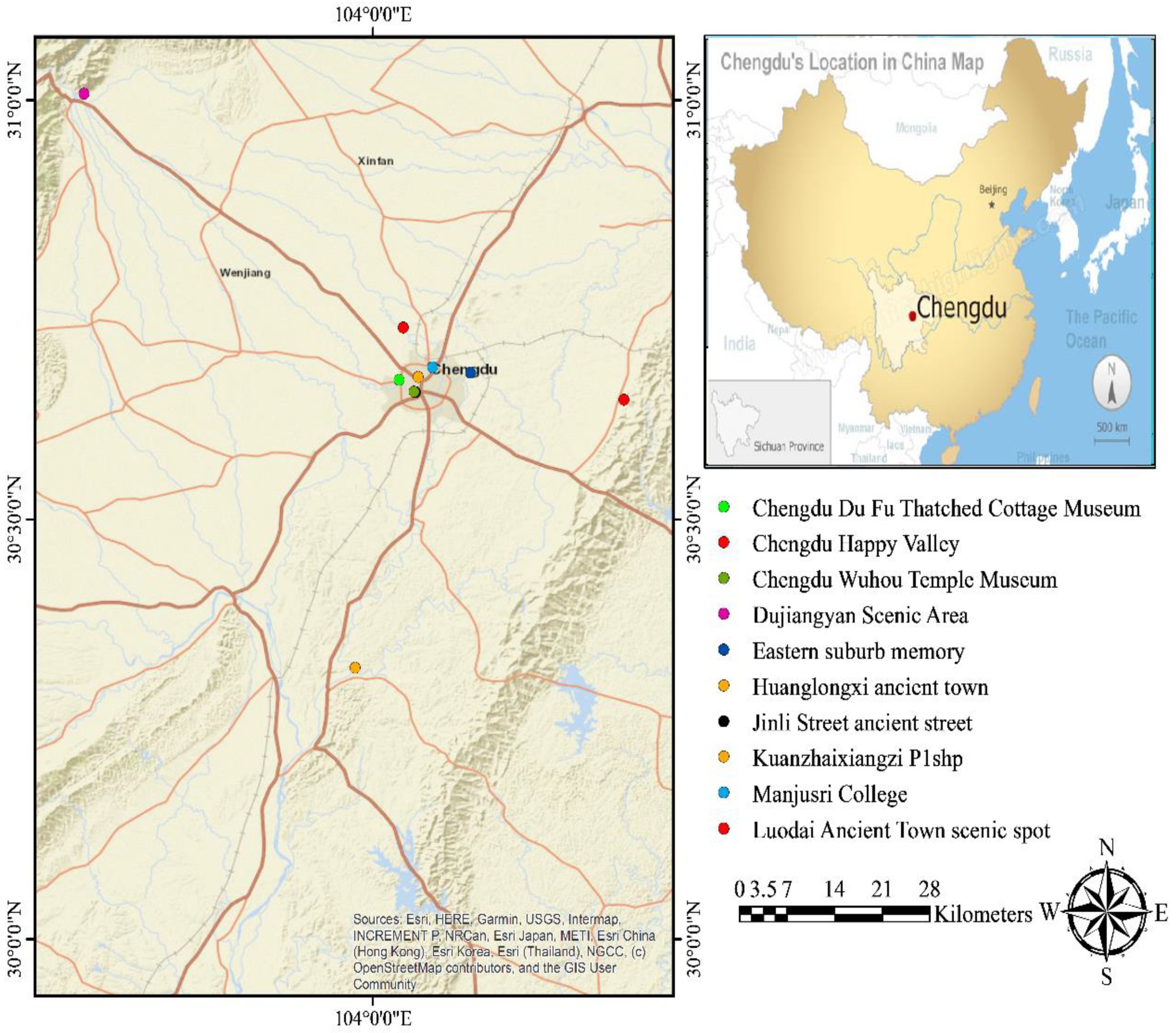
Chengdu is a Chinese provincial city, the seat of the Sichuan state government of China. The largest city in Sichuan Province has 14,427,500 people and a city-dwelling population of 10,152,632. According to the 2010 census, Chengdu was the fifth largest city in China, with a population of 10,484,996 in the built-up area, including Xinjin County and Guanghan City in Deyang. Chengdu entered the global city with a “Beta +” rating, according to the Globalization and World Cities Research Network ranking. The vast plain on which Chengdu lies is from 450 to 720 m (1480 to 2360 feet) high. Its borders on the northwest are the steep, high Longmen Mountains, and in the west are the Qionglai Heights, whose altitude exceeds 3000 m (9800 feet) and includes Miao Jiling (5364 m, 17,598 feet) and Shilling Snow Mountain (5164 m, 16,942 feet). The western region is the mountainous region where there is a huge primitive forest with plenty of food and giant panda families. The Longquan Low Mountains, east of Chengdu, and the western boundary region of the mountainous land in the middle reaches of the Min River, an area noted by many converging rivers, are located east of Chengdu. Chengdu is located on the western edge of the Sichuan Basin and on the Chengdu Plain. The dominant terrain is the plains. The prefecture ranges in latitude from 30°05′ to 31°26′ N, while its longitude ranges from 102°54′ to 104°53′ E, stretching 192 km (119 mi) from east to west and 166 km (103 mi) south to north, administering 12,390 square kilometers (4780 sq. mi) of land. There are some challenges facing tourists (especially foreign tourists) in making tours around tourist attractions easily and according to their different priorities [35]. To help solve this problem, we selected 11 famous tourist sites distributed within the city, as shown in Table 7 and Figure 5.
4. Results and Discussion
4.1. Results
The GA creates a set of solutions and generates a set of paths that serve the different purposes of tourists. Thirteen objectives rely on a genetic algorithm to determine the best path for tourists, including nine internal objectives and four external objectives. In two scenarios in which the genetic GA has been applied, the first scenario selects the objectives individually, and there are five objectives: internal objectives, total distance, total distance, cost, total time, and DTM, as shown in Table 8.
The second scenario combines all objectives, gives each objective a weight using the AHP method, and obtains the best path. Table 8 illustrates the results of the genetic algorithm using multiple objectives, as well as using a single objective separately. In this case, we calculate the matrix of each objective and determine the matrix weighted by its weight and collate it into one matrix. This matrix is a multiobjective matrix that indicates the best path based on multiple objectives, and we give it a distinction (unit).
Our computational experiments demonstrate the behavior of the GA as applied to the multiobjective urban tourism path planning optimality of solutions and computational complexity. GA results of optimal path according to multi and single objectives are as follows: multiobjective 495 unit, internal potential objective 248 unit, total cost 742 Yuan, total travel time 1440 min, total distance 278 km, differed height (h) −1.536 m. The optimal path planning between tourism destinations is as follows: internal potential objective path P10-P5-P9-P2-P8-P4-P11-P1-P7-P6-P3-P10, total cost P3-P2-P6-P5-P11-P4-P8-P7-P10-P9-P1-P3, total travel time P9-P10-P1-P6-P5-P7-P3-P8-P2-P11-P4-P9, total distance P2-P5-P6-P10-P9-P1-P4-P11-P8-P7-P3-P2, different height P9-P4-P5-P2-P3-P11-P8-P10-P6-P1-P7-P9. Table 8 shows the multiobjective path that is the best path under different objectives. The route, starting from site 2 (Kuan zhai xiang zi) and ending at Site 3 (Jinli Street ancient street), is as follows: P2-P6-P5-P11-P4-P8-P7-P10-P9-P1-P3-P2.
4.2. Discussion
The multiplicity of tourism types has proven to be a key factor in the growth and development of the tourism industry, and there are many types of tourism, such as popular tourism and luxury tourism. There are further important types of tourism: individual tourism and group tourism. Group tourism planning and arranging for visiting sites is done through tourism companies, and, in individual tourism, the planning of the tourist [36,37,38]. To compare our approach with other approaches to tourism evaluation, we chose two approaches. Hoang proposed a multicriteria evaluation of the type of tourism in Vietnam’s central highlands; 13 criteria were chosen for a multicriteria evaluation of the region’s tourism types. The AHP method weight scoring results show that the internal types of tourism are more important than their external potential. In Sahani, N presented an integrated approach to create ecotourism types using AHP and GIS methods to assess the type of ecotourism region. They were successfully applied and established. However, these methods ignored the internal objectives of tourism types. Our approach provides the option to choose the optimal path for a tourist tour, which helps in individual and group tourism service.
In this paper, we improved GA and applied it to design tourism paths. In GIS environments, such as ArcGIS, traditional algorithms use the Dijkstra algorithm. However, this algorithm does not meet the needs of the users. Therefore, the GA algorithm has been improved in this paper to provide efficient visualization and analysis to GIS network tools. Additionally, the improved GA provides the ability to combine spatial objectives for sites such as distance and nonspatial objectives such as cultural–historical objectives. In addition, it is accomplished by combining the internal and external objectives of tourist attractions. Furthermore, to verify the effectiveness of our proposed comparison, we compared our proposed algorithm to the genetic algorithm that uses traditional parameters and the ant colony optimization algorithm (ACOA) [39,40]. The obtained results are shown in Table 9. The implementation time of our proposed algorithm is 0.45 s, which is much better than that of the other two algorithms. For other objectives, the results obtained using the new algorithm are considered better than those of the other algorithms.
5. Conclusions and Future Work
The field of urban planning of tourist paths is very important to make tourism tours fast and easy; however, the existing methods used in the field have to be enhanced. In this paper, the old GA has been enhanced by a new parameter to give an optimal result and speed up the implantation time of the algorithm. Additionally, we integrate different tools for this domain in conjunction with demonstrating the applicability of using improved GA and AHP to develop tourism path planning. We also used the geographical information system (GIS) for the implementation and visualization of efficient multiobjective tourism routes. The organization of our model is as follows. First, we combined internal and external objectives for planning the tourist route and gave each objective a weight using the AHP method to obtain the best results, based on previous studies. Second, we used GA with a new parameter to obtain the optimal route. Finally, a comparison and combination with the algorithms that are currently used in the GIS environment is performed. The following points are recommended as contributions of this paper:
(1) Improving the accuracy of the genetic algorithm through the use of new parameters, which were determined through previous experiments. In addition, the results are compared with many related results, as shown in Table 8. Through the comparisons, the best results for the proposed tourist itineraries were obtained.
(2) Choosing the optimal tourism path by combining the external and internal potential of tourist sites to define tourist paths. The existing published studies have not taken internal factors into account when designing tourist paths. There is room for improvement along this line of research; for example, increasing the number of objectives and using other machine learning algorithms to make the present approach more flexible. Extending our work to other artificial intelligence techniques and multiroute hilly areas will be the next research direction.
Author Contributions
Conceptualization, Mohamed A. Damos and Jun Zhu; methodology, Weilian Li; software, Elhadi Khalifa; validation, Abubakr Hassan, Mohamed A. Damos, Weilian Li and Jun Zhu; writing—original draft preparation, Abubakr Hassan; writing—review and editing, Elhadi Khalifa; visualization, Jun Zhu; funding acquisition, Mohamed A. Damos. All authors have read and agreed to the published version of the manuscript.
Funding
This paper was supported by the National Natural Science Foundation of China (Grant Nos. U2034202, 41871289), the Sichuan Science and Technology Program (Grant No. 2020JDTD0003).
Acknowledgments
The authors would like to thank Rashad Elhabob, Lin Fu, Abdou Bouk, and Kamal Bashier, for their help to improve the paper language. We also acknowledged the editor and the anonymous reviewers for their constructive and valuable comments that largely improved the paper.
Conflicts of Interest
The authors declare no conflict of interest.
References
- Arunmozhi, T.; Panneerselvam, A. Types of tourism in India. Int. J. Curr. Res. Acad. Rev. 2013, 1, 84–88. [Google Scholar]
- Dilmonov, K.B. Classification and types of tourism. Int. Sci. Rev. 2020, 1, 41–42. [Google Scholar]
- Muhammedrisaevna, T.M.; Mubinovna, R.F.; Kizi, M.N.U. The role of information technology in organization and management in tourism. Academy 2020, 4, 34–35. [Google Scholar]
- Sahani, N. Application of analytical hierarchy process and GIS for ecotourism potentiality mapping in Kullu District, Himachal Pradesh, India. Environ. Dev. Sustain. 2019, 22, 6187–6211. [Google Scholar] [CrossRef]
- Hoang, H.T.; Truong, Q.H.; Nguyen, A.T.; Hens, L. Multicriteria Evaluation of Tourism Potential in the Central Highlands of Vietnam: Combining Geographic Information System (GIS), Analytic Hierarchy Process (AHP) and Principal Component Analysis (PCA). Sustainability 2018, 10, 3097. [Google Scholar] [CrossRef] [Green Version]
- Vystoupil, J.; Šauer, M.; Repík, O. Quantitative Analysis of Tourism Potential in the Czech Republic. Acta Univ. Agric. Silvic. Mendel. Brun. 2017, 65, 1085–1098. [Google Scholar] [CrossRef] [Green Version]
- Huang, B.; Yao, L.; Raguraman, K. Bi-level GA and GIS for Multi-objective TSP Route Planning. Transp. Plan. Technol. 2006, 29, 105–124. [Google Scholar] [CrossRef]
- Martín, J.M.; Fernández, J.A.S.; Aguilera, J.D.D.J. Assessment of the Tourism’s Potential as a Sustainable Development Instrument in Terms of Annual Stability: Application to Spanish Rural Destinations in Process of Consolidation. Sustainability 2017, 9, 1692. [Google Scholar] [CrossRef] [Green Version]
- Cergibozan, Ç.; Tasan, A.S. Tourist Route Planning with a Metaheuristic Approach. In Closing the Gap between Practice and Research in Industrial Engineering; Springer: Cham, Switzerland, 2017; pp. 193–199. [Google Scholar]
- Nestorosk, I. Identifying Tourism Potentials in Republic of Macedonia Through Regional Approach. Procedia Soc. Behav. Sci. 2012, 44, 95–103. [Google Scholar] [CrossRef] [Green Version]
- Darabseh, F.M.; Ababneh, A.; AlMuhaisen, F. Assessing Umm el-Jimal’s Potential for Heritage Tourism. Archaeologies 2017, 13, 460–488. [Google Scholar] [CrossRef]
- Byon, Y.; Abdulhai, B.; Shalaby, A. Incorporating Scenic View, Slope, and Crime Rates into Route Choices: Emphasis on 3-D GIS with Digital Elevation Models and Crime Rate Geospatial Data. Transp. Res. Rec. J. Transp. Rev. Board 2010, 2183, 94–102. [Google Scholar] [CrossRef]
- Shafiee, S.; Rajabzadeh Ghatari, A.; Hasanzadeh, A.; Jahanyan, S. Developing a model for sustainable smart tourism destinations: A systematic review. Tour. Manag. Perspect. 2019, 31, 287–300. [Google Scholar] [CrossRef]
- Yuan, C.; Uehara, M. An Optimal Travel Route Recommendation System for Tourists’ First Visit to Japan. In Advanced Information Networking and Applications, Proceedings of the 2019 Advances in Intelligent Systems and Computing, Matsue, Japan, 27–29 March 2019; Springer: Cham, Switzerland, 2019; pp. 872–882. [Google Scholar]
- Gündling, F.; Witzel, T. Time-Dependent Tourist Tour Planning with Adjustable Profits. In Proceedings of the 20th Symposium on Algorithmic Approaches for Transportation Modelling, Optimization, and Systems (ATMOS 2020), Pisa, Italy, 7–8 September 2020. [Google Scholar]
- LLi, R.; Leung, Y.; Huang, B.; Lin, H. A genetic algorithm for multiobjective dangerous goods route planning. Int. J. Geogr. Inf. Sci. 2013, 27, 1073–1089. [Google Scholar] [CrossRef]
- Darko, A.; Chan, A.P.C.; Ameyaw, E.E.; Owusu, E.K.; Parn, E.; Edwards, D.J. Review of application of analytic hierarchy process (AHP) in construction. Int. J. Constr. Manag. 2019, 19, 436–452. [Google Scholar] [CrossRef]
- Baffoe, G. Exploring the utility of Analytic Hierarchy Process (AHP) in ranking livelihood activities for effective and sustainable rural development interventions in developing countries. Eval. Program Plan. 2019, 72, 197–204. [Google Scholar] [CrossRef]
- Petruni, A.; Giagloglou, E.; Douglas, E.; Geng, J.; Leva, M.C.; Demichela, M. Applying Analytic Hierarchy Process (AHP) to choose a human factors technique: Choosing the suitable Human Reliability Analysis technique for the automotive industry. Saf. Sci. 2019, 119, 229–239. [Google Scholar] [CrossRef] [Green Version]
- Cetin, M.; Sevik, H. Evaluating the recreation potential of Ilgaz Mountain National Park in Turkey. Environ. Monit. Assess. 2015, 188, 1–10. [Google Scholar] [CrossRef] [PubMed]
- Cao, K.; Liu, M.; Wang, S.; Liu, M.; Zhang, W.; Meng, Q.; Huang, B. Spatial Multi-Objective Land Use Optimization toward Livability Based on Boundary-Based Genetic Algorithm: A Case Study in Singapore. ISPRS Int. J. Geo-Inf. 2020, 9, 40. [Google Scholar] [CrossRef] [Green Version]
- Zheng, S.; Liu, Y.; Ouyang, Z. A machine learning-based tourist path prediction. In Proceedings of the 2016 4th International Conference on Cloud Computing and Intelligence Systems (CCIS), Beijing, China, 17–19 August 2016; pp. 38–42. [Google Scholar]
- Fitriansyah, A.; Parwati, N.W.; Wardhani, D.R.; Kustian, N. Dijkstra’s Algorithm to Find Shortest Path of Tourist Destination in Bali. J. Phys. Conf. Ser. 2019, 1338, 012044. [Google Scholar] [CrossRef] [Green Version]
- Rivero, M.S.; Martín, J.M.S.; Gallego, J.I.R. Methodological approach for assessing the potential of a rural tourism destination: An application in the province of Cáceres (Spain). Curr. Issues Tour. 2014, 19, 1084–1102. [Google Scholar] [CrossRef]
- Taherdoost, H. Decision making using the analytic hierarchy process (AHP); A step by step approach. Int. J. Econ. Manag. Syst. 2017, 2, 244–246. [Google Scholar]
- Kumar, R.; Anbalagan, R. Landslide susceptibility mapping using analytical hierarchy process (AHP) in Tehri reservoir rim region, Uttarakhand. J. Geol. Soc. India 2016, 87, 271–286. [Google Scholar] [CrossRef]
- Wind, Y.; Saaty, T.L. Marketing applications of the analytic hierarchy process. Manag. Sci. 1980, 26, 641–658. [Google Scholar] [CrossRef]
- Saranya, T.; Saravanan, S. Groundwater potential zone mapping using analytical hierarchy process (AHP) and GIS for Kancheepuram District, Tamilnadu, India. Model. Earth Syst. Environ. 2020, 6, 1105–1122. [Google Scholar] [CrossRef]
- Tahir, M.; Tubaishat, A.; Al-Obeidat, F.; Shah, B.; Halim, Z.; Waqas, M. A novel binary chaotic genetic algorithm for feature selection and its utility in affective computing and healthcare. Neural Comput. Appl. 2020, 1–22. [Google Scholar] [CrossRef]
- Karami, H.; Farzin, S.; Jahangiri, A.; Ehteram, M.; Kisi, O.; El-Shafie, A. Multi-Reservoir System Optimization Based on Hybrid Gravitational Algorithm to Minimize Water-Supply Deficiencies. Water Resour. Manag. 2019, 33, 2741–2760. [Google Scholar] [CrossRef]
- Valikhan-Anaraki, M.; Mousavi, S.-F.; Farzin, S.; Karami, H.; Ehteram, M.; Kisi, O.; Fai, C.M.; Hossain, S.; Hayder, G.; Ahmed, A.N.; et al. Development of a Novel Hybrid Optimization Algorithm for Minimizing Irrigation Deficiencies. Sustainability 2019, 11, 2337. [Google Scholar] [CrossRef] [Green Version]
- Hussain, A.; Muhammad, Y.S.; Sajid, M.N.; Hussain, I.; Shoukry, A.M.; Gani, S.H. Genetic Algorithm for Traveling Salesman Problem with Modified Cycle Crossover Operator. Comput. Intell. Neurosci. 2017, 2017, 1–7. [Google Scholar] [CrossRef] [PubMed]
- Liang, Y.; Wang, L. Applying genetic algorithm and ant colony optimization algorithm into marine investigation path planning model. Soft Comput. 2019, 24, 8199–8210. [Google Scholar] [CrossRef]
- Krajčovič, M.; Hančinský, V.; Dulina, Ľ.; Grznár, P.; Gašo, M.; Vaculík, J. Parameter Setting for a Genetic Algorithm Layout Planner as a Toll of Sustainable Manufacturing. Sustainability 2019, 11, 2083. [Google Scholar] [CrossRef] [Green Version]
- Myron, A.; Levine, B. Urban Politics: Cities and Suburbs in a Global Age, 10th ed.; Routledge: New York, NY, USA, 2019. [Google Scholar] [CrossRef]
- Jeong, C.-S.; Lee, J.-Y.; Jung, K.-D. Adaptive recommendation system for tourism by personality type using deep learning. Int. J. Internet Broadcast. Commun. 2020, 12, 55–60. [Google Scholar]
- Nurov, Z.; Khamroyeva, F.; Kadirova, D. Development of domestic tourism as a priority of the economy. In Proceedings of the 2021 E-Conference Globe, New York, NY, USA, 12–16 July 2021; pp. 271–275. [Google Scholar]
- Dilrabo, T.; Shamsiddinovna, A.N. Typological Overview of Tourism and the Advent of New Types of Tours. A Multidiscip. Peer Rev. J. Organized by Novateur Publications, Pune, Maharashtra, India, July 11th and 12th 2020. 2020, 1–4. [Google Scholar]
- Yi, N.; Xu, J.; Yan, L.; Huang, L. Task optimization and scheduling of distributed cyber–physical system based on improved ant colony algorithm. Futur. Gener. Comput. Syst. 2020, 109, 134–148. [Google Scholar] [CrossRef]
- Ali, H.; Gong, D.; Wang, M.; Dai, X. Path Planning of Mobile Robot With Improved Ant Colony Algorithm and MDP to Produce Smooth Trajectory in Grid-Based Environment. Front. Neurorobot. 2020, 14, 44. [Google Scholar] [CrossRef]
Figure 1.
Process of finding the best route.

Figure 2.
The GA operations.

Figure 3.
A chromosome representation example.
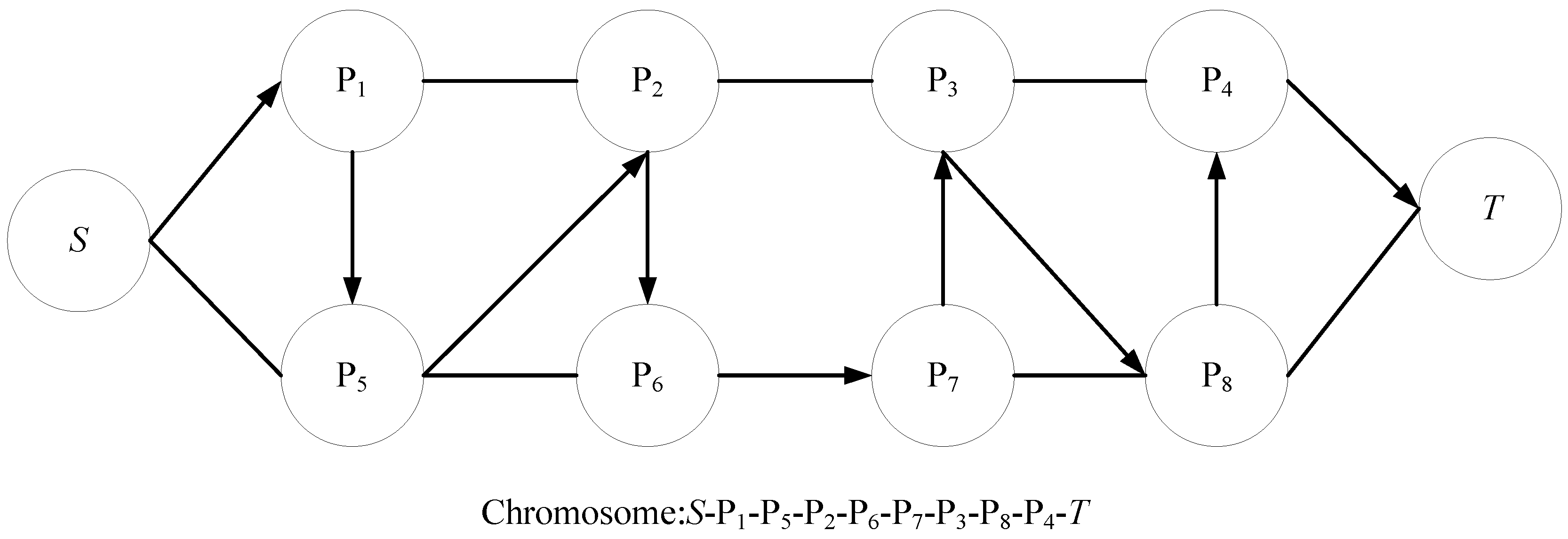
Figure 4.
The GA operation.
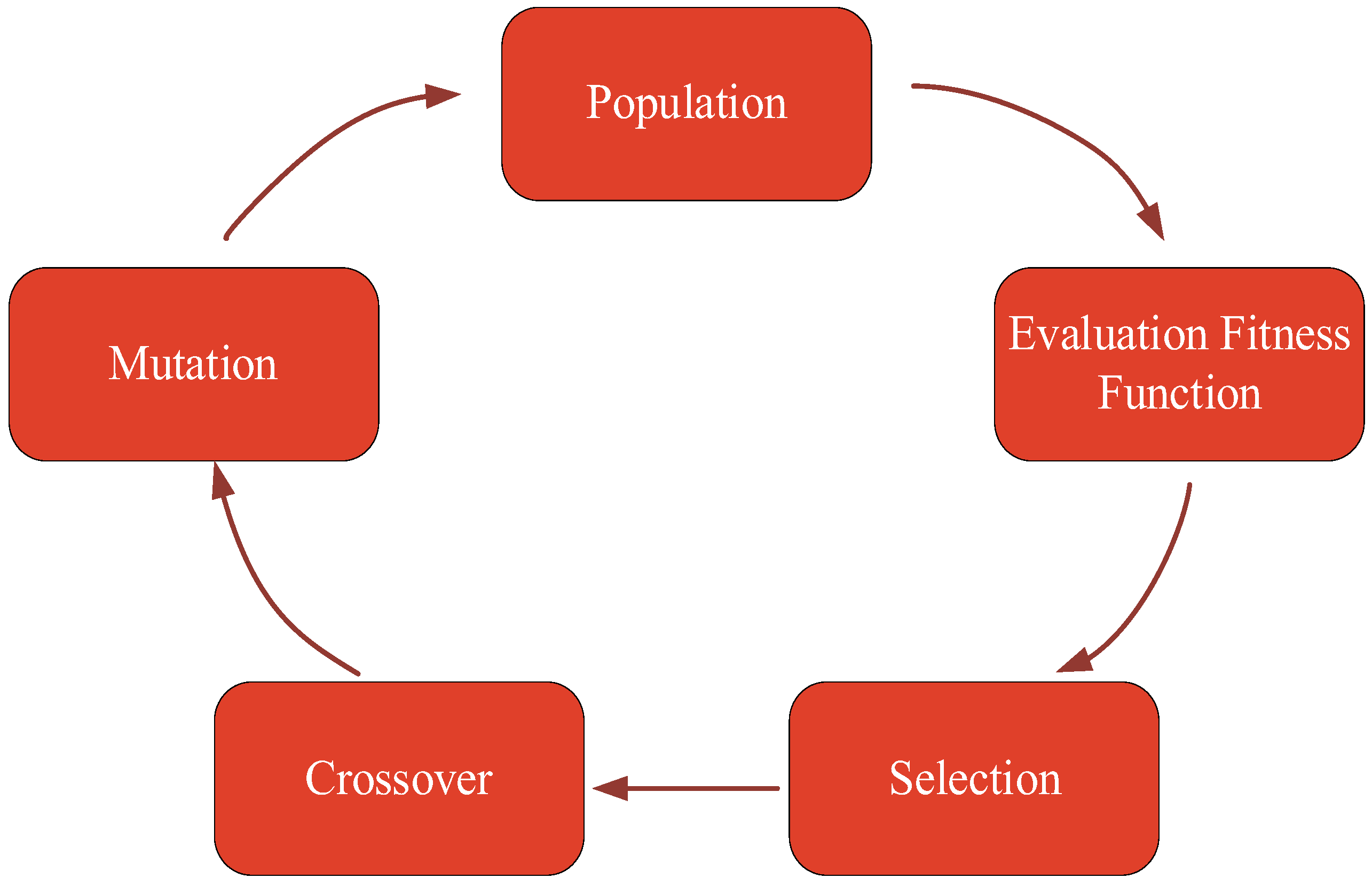
Figure 5.
Tourist sites distributed within the city.

Table 1.
Internal tourism resources.
| Selected Objective | Explanation and References | Evaluation Scale | Rating |
|---|---|---|---|
| entertainment value (EN) | The value of entertainment refers to the entertainment available in the tourist site, which is available to the visitor. | Very high | 10 |
| High | 7 | ||
| Medium | 4 | ||
| Low | 1 | ||
| aesthetic and art (AA) | Aesthetics and arts include the aesthetic and artistic sensitivity. The practical, cultural, and philosophical qualities of the site. | Very high | 10 |
| High | 7 | ||
| Medium | 4 | ||
| Low | 1 | ||
| Cultural–historical value (CH) | The historical and cultural value is considered to be one of the most important factors that influences tourists’ flocking to tourist sites. | Very high | 10 |
| High | 7 | ||
| Medium | 4 | ||
| Low | 1 | ||
| scientific value (SI) | The scientific value of the tourist site indicates the scientific importance of the site, such as universities and others. | Very high | 10 |
| High | 7 | ||
| Medium | 4 | ||
| Low | 1 | ||
| size of tourism destination (TD) | The size of the tourist destination, the height of the place, and the tourist destination’s ability to accommodate tourists. | >50 km2 | 10 |
| >10–50 km2 | 7 | ||
| 1–10 km2 | 4 | ||
| <1 km2 | 1 | ||
| tourism seasonality (TS) | Tourism seasonality is the possibility of visiting tourist sites in a specific season of the year; some sites can be visited year-round, such as museums, while some sites have seasonality, such as gardens. | >300 days/year | 10 |
| >200–300 days/year | 7 | ||
| 100–200 days/year | 4 | ||
| <100 days/year | 1 | ||
| quality of service (QS) | quality of service includes all services provided within tourist sites, such as restaurants, cafes, shops, and others. | Very high | 10 |
| High | 7 | ||
| Medium | 4 | ||
| Low | 1 | ||
| time in site (TI) | This includes the time spent by the visitor inside the site, taking into account the opening and closing times of the gates. | >3 | 10 |
| >2–3 | 7 | ||
| >1–2 | 4 | ||
| 0–1 | 1 | ||
| Biodiversity (BI) | The value of biological diversity is evaluated according to the different types of endemic animals. | Very high | 10 |
| High | 7 | ||
| Medium | 4 | ||
| Low | 1 |
Table 2.
Total Travel Time Matrix.
| AP | KZ | JSAS | DSA | MS | ESM | CWTM | CDTM | HAT | LATS | CHV | |
|---|---|---|---|---|---|---|---|---|---|---|---|
| Airport (AP) | 0 | 165 | 129 | 202 | 136 | 88 | 100 | 129 | 184 | 116 | 232 |
| Kuanzhaixiangzi(KZ) | 165 | 0 | 109 | 197 | 105 | 73 | 82 | 109 | 198 | 117 | 204 |
| Jinli Street ancient street (JSAS) | 129 | 109 | 0 | 199 | 110 | 77 | 63 | 105 | 187 | 147 | 215 |
| Dujiangyan Scenic Area (DSA) | 202 | 197 | 199 | 0 | 177 | 131 | 152 | 170 | 215 | 151 | 253 |
| Manjusri College (MS) | 136 | 105 | 110 | 177 | 0 | 62 | 80 | 116 | 198 | 112 | 204 |
| Eastern suburb memory (ESM) | 88 | 73 | 77 | 131 | 62 | 0 | 97 | 125 | 200 | 89 | 209 |
| Chengdu Wuhou Temple Museum (CWTM) | 100 | 82 | 63 | 152 | 80 | 97 | 0 | 105 | 182 | 119 | 210 |
| Chengdu DuFu Thatched Cottage Museum (CDM) | 129 | 109 | 105 | 170 | 116 | 125 | 105 | 0 | 188 | 123 | 207 |
| Huanglongxi ancient town (HAT) | 184 | 198 | 187 | 215 | 198 | 200 | 182 | 188 | 0 | 145 | 270 |
| Luodai Ancient Town scenic spot (LATS) | 116 | 117 | 147 | 151 | 112 | 89 | 119 | 123 | 145 | 0 | 227 |
| Chengdu Happy Valley (CHV) | 232 | 204 | 215 | 253 | 204 | 209 | 210 | 207 | 270 | 227 | 0 |
Table 3.
Saaty’s 1–9 Scale of Relative Importance.
| Scale | Importance |
|---|---|
| 1 | Equal importance |
| 2 | Weak |
| 3 | Moderate importance |
| 4 | Moderate plus |
| 5 | Strong importance |
| 6 | Strong plus |
| 7 | Very strong importance |
| 8 | Very strong plus |
| 9 | Extreme importance |
Table 4.
Importance of Internal Objectives Resources (average values of the experts’ valuation).
| EN | AA | CH | SI | TD | TS | QS | TI | BI | Weight Score | |
|---|---|---|---|---|---|---|---|---|---|---|
| Entertainment value (EN) | 1.00 | 0.52 | 0.60 | 2.90 | 5.50 | 5.60 | 0.50 | 0.50 | 3.90 | 0.12 |
| Aesthetic and art (AA) | 1.92 | 1.00 | 0.60 | 2.50 | 6.00 | 5.60 | 0.90 | 0.90 | 3.90 | 0.15 |
| Cultural -historical value (CH) | 1.67 | 1.67 | 1.00 | 3.80 | 6.20 | 5.80 | 3.50 | 3.50 | 5.20 | 0.25 |
| Scientific value (SI) | 0.34 | 4.00 | 0.26 | 1.00 | 6.20 | 5.60 | 0.50 | 0.50 | 3.20 | 0.09 |
| Size of tourism destination (TD) | 0.18 | 0.16 | 0.16 | 0.16 | 1.00 | 1.30 | 0.25 | 0.25 | 0.16 | 0.02 |
| Tourism seasonality (TS) | 0.18 | 5.50 | 0.17 | 0.18 | 0.78 | 1.00 | 0.33 | 0.33 | 0.18 | 0.08 |
| Quality of service (QS) | 2.00 | 1.11 | 0.29 | 2.00 | 4.00 | 3.00 | 1.00 | 1.00 | 2.00 | 0.11 |
| Time in site (TI) | 2.00 | 1.18 | 0.29 | 2.00 | 4.00 | 3.00 | 1.00 | 1.00 | 2.00 | 0.11 |
| Biodiversity (BI) | 0.26 | 0.26 | 0.19 | 0.31 | 6.20 | 5.50 | 0.50 | 0.50 | 1.00 | 0.07 |
Table 5.
Matrix Importance of Combining Internal and External Objectives.
| IR | TC | TD | TO | DTM | Weight Score | |
|---|---|---|---|---|---|---|
| Internal resources (IR) | 1.00 | 1.00 | 2.00 | 2.00 | 3.00 | 0.30 |
| Total cost (TC) | 1.00 | 1.00 | 2.00 | 2.00 | 3.00 | 0.30 |
| Total distance (TD) | 0.50 | 0.50 | 1.00 | 1.00 | 1.50 | 0.15 |
| time out site (TO) | 0.50 | 0.50 | 2.00 | 1.00 | 1.50 | 0.15 |
| Digital terrain model (DTM) | 0.33 | 0.33 | 0.67 | 0.67 | 1.00 | 0.10 |
Table 6.
Parameter settings of GA.
| Parameters | Values |
|---|---|
| Population size | 100 |
| Crossover probability | 0.85 |
| Mutation probability | 0.10 |
| Number of generations | 4000 |
Table 7.
Tourist Sites Distributed Within the City.
| NO | X | Y | Name |
|---|---|---|---|
| P1 | 104.000000 | 30.000000 | Airport |
| P2 | 104.059763 | 30.669938 | Kuan zhai xiang zi |
| P3 | 104.056424 | 30.651723 | Jinli Street ancient street |
| P4 | 103.617627 | 31.007930 | Dujiangyan Scenic Area |
| P5 | 104.079149 | 30.681353 | Manjusri College |
| P6 | 104.129446 | 30.674976 | Eastern suburb memory |
| P7 | 104.054572 | 30.652582 | Chengdu Wuhou Temple Museum |
| P8 | 104.034848 | 30.666397 | Chengdu Du Fu Thatched Cottage Museum |
| P9 | 103.976489 | 30.323445 | Huanglongxi ancient town |
| P10 | 104.332434 | 30.643115 | Lidia Ancient Town scenic spot |
| P11 | 104.040307 | 30.729004 | Chengdu Happy Valley |
Table 8.
Tourist path based on objectives.
| No. | The Objectives | The Path | Note |
|---|---|---|---|
| 1 | Multiobjective | P2-P6-P5-P11-P4-P8-P7-P10-P9-P1-P3-P2 | Optimal path |
| 2 | Internal objectives | P10-P5-P9-P2-P8-P4-P11-P1-P7-P6-P3-P10 | |
| 3 | Cost objective | P3-P2-P6-P5-P11-P4-P8-P7-P10-P9-P1-P3 | |
| 4 | Total distance objective | P2-P5-P6-P10-P9-P1-P4-P11-P8-P7-P3-P2 | |
| 5 | Total time objective | P9-P10-P1-P6-P5-P7-P3-P8-P2-P11-P4-P9 | |
| 6 | DTM objective | P9-P4-P5-P2-P3-P11-P8-P10-P6-P1-P7-P9 |
Table 9.
Comparisons of experimental results.
| Algorithm | Time Optimizes (s) | Multi Objective (Unit) | Internal Potential (Unit) | Cost (Yuan) | Travel Time (min) | Height (km) | Distance (m) |
|---|---|---|---|---|---|---|---|
| Traditional GA | 1.664 | 503 | 250 | 803 | 1387 | 298 | −1.50 |
| ACOA | 0.890 | 497 | 252 | 825 | 1390 | 279 | −1.398 |
| Improved GA | 0.450 | 495 | 248 | 742 | 1440 | 278 | −1.536 |
Publisher’s Note: MDPI stays neutral with regard to jurisdictional claims in published maps and institutional affiliations. |
© 2021 by the authors. Licensee MDPI, Basel, Switzerland. This article is an open access article distributed under the terms and conditions of the Creative Commons Attribution (CC BY) license (https://creativecommons.org/licenses/by/4.0/).
Share and Cite
MDPI and ACS Style
Damos, M.A.; Zhu, J.; Li, W.; Hassan, A.; Khalifa, E. A Novel Urban Tourism Path Planning Approach Based on a Multiobjective Genetic Algorithm. ISPRS Int. J. Geo-Inf. 2021, 10, 530. https://doi.org/10.3390/ijgi10080530
AMA Style
Damos MA, Zhu J, Li W, Hassan A, Khalifa E. A Novel Urban Tourism Path Planning Approach Based on a Multiobjective Genetic Algorithm. ISPRS International Journal of Geo-Information. 2021; 10(8):530. https://doi.org/10.3390/ijgi10080530
Chicago/Turabian StyleDamos, Mohamed A., Jun Zhu, Weilian Li, Abubakr Hassan, and Elhadi Khalifa. 2021. "A Novel Urban Tourism Path Planning Approach Based on a Multiobjective Genetic Algorithm" ISPRS International Journal of Geo-Information 10, no. 8: 530. https://doi.org/10.3390/ijgi10080530
Note that from the first issue of 2016, this journal uses article numbers instead of page numbers. See further details here.