1. Introduction
“Entering the knowledge economy is undoubtedly a high-risk strategy, but if, as suggested, the commons are conceived as a complex adaptive system where each constitutive element has autonomy, then there may be one last chance for survival [
1].”
The digital knowledge and information economy is well underway. If you have a cell phone, use a computer, or post on Instagram, you are a full-fledged participant within what Manual Castells called the Network Society [
2]. By now, many of us are aware that digital technologies are simultaneously transformative and disruptive, and geospatial technologies, such as geographic information systems (GIS) and digital mapping, can both empower and marginalize society [
3]. We are also aware that digital technologies can assist human beings in unleashing creativity, diffuse information quickly, and strengthen new teaching/learning approaches. GIS are commonplace in geography departments and classrooms in the United States. Several scholars, including the first author of this article, warned of the transformative capabilities of GIS and how the technologies could disassociate Indigenous geographic knowledge from its parent context as well as deskill elder knowledge [
4,
5,
6]. However, over the last couple of decades, GIS became prevalent within Indian Country. However, this paper is neither about tribal communities nor government agencies. Rather, we explore how antiquated, forgotten Indigenous materials, such as historical maps, can be brought back to life and reimagined in university classrooms using digital devices.
How might we teach undergraduate students about Indigenous geographies using historical maps? For many scholars, maps are a good option. The difficulty arises when trying to find physical maps made by or for Indigenous peoples [
7]. A wealth of secondary sources about the history of cartography are available including research by Warhus [
8] and Lewis [
9]. Additional source materials are found in critical map and GIS studies [
10,
11,
12,
13,
14]. The best resource for finding the location of potential Indigenous maps within American archives is Lewis [
9]. Lewis’ book entitled Cartographic Encounters is particularly important because it identifies archives that have yet to be studied thoroughly by scholars. As the title suggests, there have been 400 plus years of encounters and exchanges between indigenous peoples and Europeans. Especially important is Chapter 2, “Encounters in Government Bureaus, Archives, Museums, and Libraries”. Much of the important information regarding the sources or where to find Indigenous maps in North American is found in the chapter’s extensive notes. We are primarily interested in North American Plains Indian maps and representations. Warhus provides an outstanding account of North American Plains Indian Maps [
8]. Another important work is “Maps, Mapmaking, and Map Use by Native North Americans” found in the History of Cartography series, Volume 2, Book 3, Chapter 4. Plains Indian maps contain rich pictorial images, similar to ledger drawings, painted on animal hides or paper using pencils and paint. Many of the historical maps present spatial stories of war and hunting. In addition, government officials, surveyors, and explorers requested maps showing geographic features such as rivers, mountains, and trails [
15].
A historical Kiowa map, estimated to have been created around 1895 [
16] on the Great Plains of what is now known as southwestern Oklahoma and the Kiowa, Comanche, and Apache (KCA) reservation area, is archived at the Smithsonian Institution in Washington, DC. The map was created by Chál-k
o-gái, (Black Goose) born in 1844 to an influential Kiowa family in the KCA Reservation (p. 269). Meadows mentioned that Chál-k
o-gái was the last generation of pre-reservation Kiowas. He served as a judge for the Court of Indian Offenses [
16] (pp. 268–269). Approached in the 1890s by US attorneys involved in the boundary disputes of US vs Texas, Chál-k
o-gái created his map to provide information about the KCA Reservation’s boundaries [
16] (p. 270). The map, however, is a Kiowa male representation of geography. A study of the gendering of Kiowa geographies or Plains Indian cartography has yet to emerge in the literature. What the map embodies are key aspects of European–Indigenous relationships conveyed through Kiowa art and oral traditions. Meadows studied the map and published his findings in the
Great Plains Journal and in his book Ethnogeography of the Kiowas [
16,
17]. Through Meadows’ work, map readers are now able to identify features and compare them with place names found in Mooney [
18] and landscape features of Kiowa country. What map readers now have is a systematic inventory of some Kiowa place names and associated mapped features to work with and think about in both historical and contemporary contexts.
This paper describes processes associated with the bridging of a historical Kiowa map with computerized geographic information systems (GIS) and undergraduate geography curriculum. Of course, the merging of old and new technologies is not a new process. Currently, universities are transforming archival materials into digital constructs that are more readily accessible to students, faculty, and the public. Some digital constructs include manuscripts, books, photographs, and maps. Furthermore, what is interesting about our case study is the opportunities for archived Indigenous representations, such as maps, to bridge and decolonize using current technoscience such as GIS, geography curriculum, dome planetariums, or virtual reality environments. It is our hope that this paper will shed some light on the Indigenous knowledge and digital technology debate. Artists, technicians, and academics are experimenting with Indigenous representations in various forms to revitalize language, to understand changing environmental conditions, and spatially represent stories [
19]. In what follows, we first present indigital frameworks as a heuristic for engaging with and combining Indigenous and Western knowledge systems. Our focus is on GIS and mapping. Next, we describe the origin of the indigital Kiowa map used in the undergraduate curriculum in the Department of Geography at the University of Missouri by a professor who is a member of the Kiowa Tribe of Oklahoma. Finally, we present some brief conclusions and ideas for future inquiry.
2. Indigital Framework
Indigital describes the creative merging of Indigenous knowledge systems with digital technologies [
19,
20,
21,
22]. Here, we are talking about the merging of Indigenous knowledge systems within the realm of geospatial sciences or GIScience. Indigenous scholars are in the position to “bring separate fields of inquiry together by merging ideas and concepts and in effect create new sciences that weld together bodies of knowledge” [
23]. The key ideas present in Vine Deloria, Jr.’s statement are “separation” and “merging”. On the one hand, Deloria is making a statement about the way the world is organized and ideas are separated. Separation does not imply equality. Rather, some ideas are given priority over the ideas of others. Separation can denote that there is a right way and a wrong way of doing things. Separation explicitly denotes real or imaginary boundaries too. Boundaries clearly separate two or more things from coming together. In other words, we have the creation of binary opposites. Merging denotes the coming together of two or more things. If boundaries are permeable between ideas and concepts, they may come together and form something new, changing as ideas and concepts change. Only within such merging spaces can indigital constructs exist within the realm of relatedness. This is not an easy task. Land and human systems have been corrupted. Separation is partially the result of settler colonialism that includes the breaking up of tribalism, the dispossession of land, dismissing Indigenous knowledge systems, and resources grabs. As a result, indigitization must be sensitive to these realities; it requires some thought.
The fields of science and technology offer hope regarding the blending of ideas. Deloria proposed:
“It is my hope that the present generation of Indian students will adopt some version of this [relatedness] methodology as they are studying Western science, particularly social and biological science, and leapfrog into prominence in their fields by writing and teaching from an Indian perspective. In this way science will move very quickly into a more intelligent understanding of the natural world.”
Gregory Cajete argued that:
“As we enter the first decade of the millennium, Native and Western cultures and their seemingly irreconcilably different ways of knowing and relating to the natural world are finding common ground and a basis for dialogue, the integration or the lack thereof will determine the direction of contemporary society in the twenty-first century.”
Adopting indigital forms of mapping and GIS takes up the challenges presented by Deloria and Cajete.
The first author has presented cases and experimented with Indigital constructs in past research, specifically digital mapping, GIS, and storytelling [
19,
25]. Doris Schoenhoff described the possibilities that could arise when Indigenous knowledge and computer interfaces collide [
26]. Her study was broad and opened the door for future work to describe the Indigenous knowledge system/technoscience interface within a global context. To our dismay, Indigenous peoples and their systems are often left out or marginalized within global conversations on the environment, space, time, place, and technoscience in general. The indigital framework strives to remedy and bridge the gap between these important conversations [
22]. How might we think about indigital constructs?
First, indigital constructs emerge locally as individuals or groups experiment with native languages, symbols, song, dance, or other representations within digital computer environments. For instance, an elder’s stories could be recorded and georeferenced to create a new indigital native language network GIS [
19]. Typically, network GIS is used to find the shortest, most economic paths between points A and B. Any stop or disruption in the highway network creates an impedance. Indigitization subverts the notion of impedances and reimages those stops as storytelling places. A native language network GIS is not built for efficiency, but rather it is loaded with cultural information and knowledge of kinship relations and land allotments. The stories and travel routes reveal a local richness that captures and reimagines gridded GIS spaces of exchange. Within spaces of exchange, cultural systems, such as language and technology, do not stand alone as dichotomous entities. Rather, they merge together and can present the stories, views, ideas, and dreams of native peoples.
There is evidence that Indigenous knowledge systems and digital technologies are combinable. Combinability relies on the convergent capabilities of digital technologies and the creativity of individuals or groups of people and their intent. Universities are places of innovation, including language revitalization programs arising at Northern Arizona University [
27,
28], Cherokee digital storytelling and keyboard design, Kiowa language network mapping, Indigenous virtual realities at the University of Missouri [
19,
22], and the publication of the Kiowa “Rabbit” songs on compact discs at the University of Oklahoma, Sam Noble Museum [
29]. Ideally, developing projects that incorporate the knowledge and experience of elders creates a virtual environment for sharing knowledge and information that might otherwise simply die off with the holders.
Combining leads to indigital constructions that are hybrid new spaces for engagement globally [
30]. Indigitization requires acceptance of multiplicity. Fundamentally, knowledge systems, such as storytelling, are open to change. When systems are nurtured locally, it could be argued that a certain level of stability might emerge, and the local community would have some sense of control over the shaping of their knowledge systems. Community language teachers, word processors, orthographies, computer hardware and software, and smart phones might stabilize systems such as the Kiowa language, Otomi calendars, or the Cherokee syllabary. Things change when they travel across space and time. All knowledge and information systems change when they become mobile and encounter other people, materials, and ideas [
31].
Perpetuation of indigital constructs is determined by reciprocity between systems. In other words, indigitization relies on bridges constructed between indigenous and scientific knowledge systems. If a one-way flow occurs, the bridge may collapse, and work will cease.
For example, one-way flows of knowledge are revealed when Cherokee or other Indigenous informants who provide place names to Apple, Microsoft, or Google realize that their own geographies are not represented. They are erased from the maps. Indigenous geographies are often trivialized as being local, vernacular, and particular to a culture which goes against the grain of technoscience standardization and universalization. The trick of indigital reciprocity is shared power, networking [
32], assemblages [
33], decentralization, trust, and collective responsibility. If all these relations are in place, community problems have a chance of success [
22].
Indigital constructions are simultaneously everywhere and nowhere. We have already mentioned a few examples above. Many of these indigital places are universities and native communities that have access to computer hardware and software. Likewise, the indigital, as a concept and idea, can be very distant. At present, there is no way around this contradiction. It is the reality of a digital divide that is still very present in the world today. One modest remedy is to continue providing examples of how indigitization might emerge at universities and native communities in general. On the other hand, native communities may not be interested at all in indigital constructs, frameworks, or philosophy. They may approach their knowledge and information far beyond the webs of digital technologies and the information economy.
Indigital frameworks can assist students and scholars in taking a leap into unknown territories (spaces of encounters and exchanges) that blend Indigenous knowledge with Western knowledge systems. In essence, we are continuing the 400 plus year encounter and exchange because good and important ideas can emerge. Our approach is modest, using maps and GIS to teach undergraduates about Indigenous knowledge systems, how they are different, and how they are related to Western systems. The example we provide is an engagement with a historic Kiowa map, that as canvas material lies way in the archives of the Smithsonian Institution but also has a life of its own as an indigital construct.
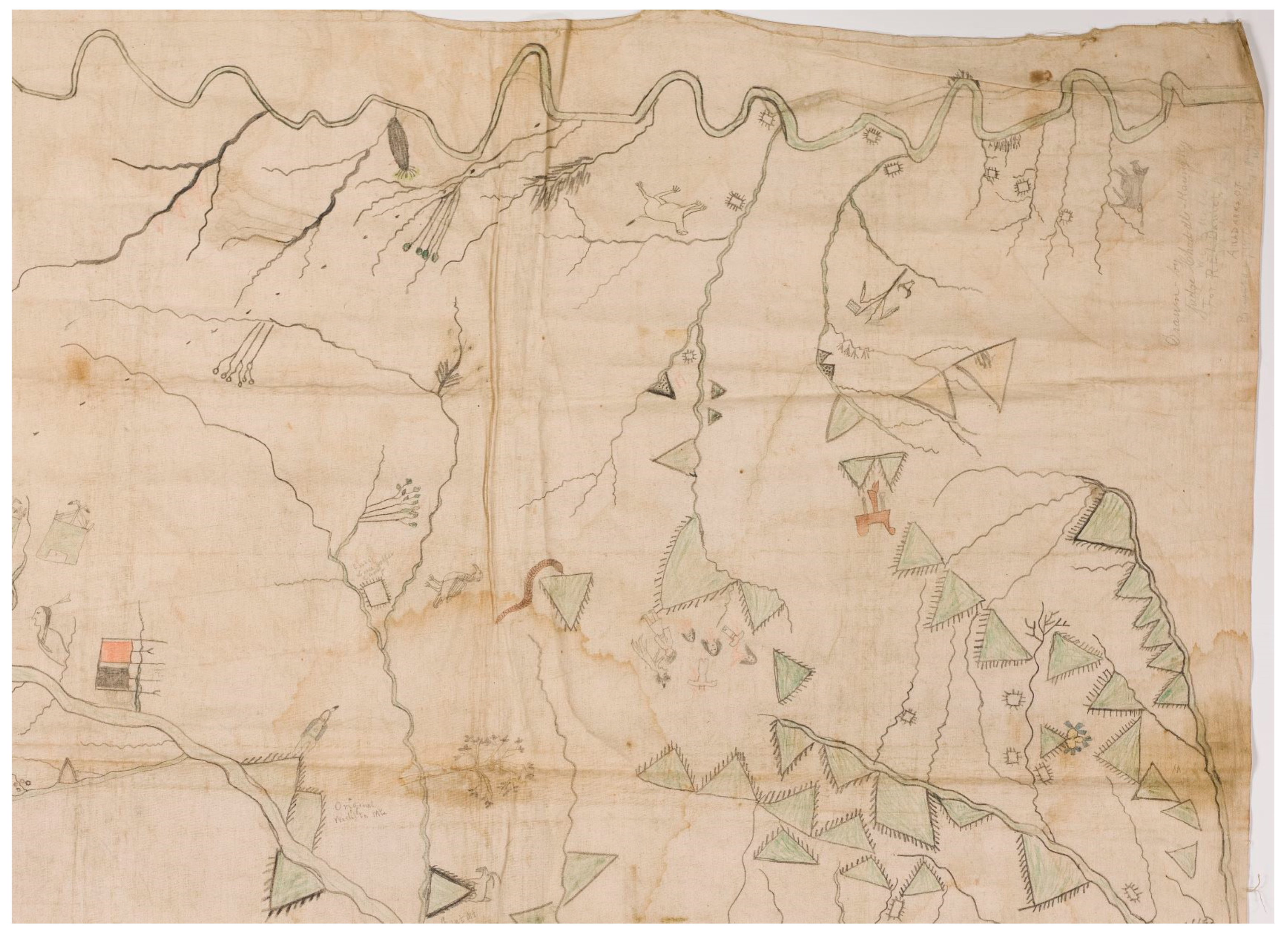
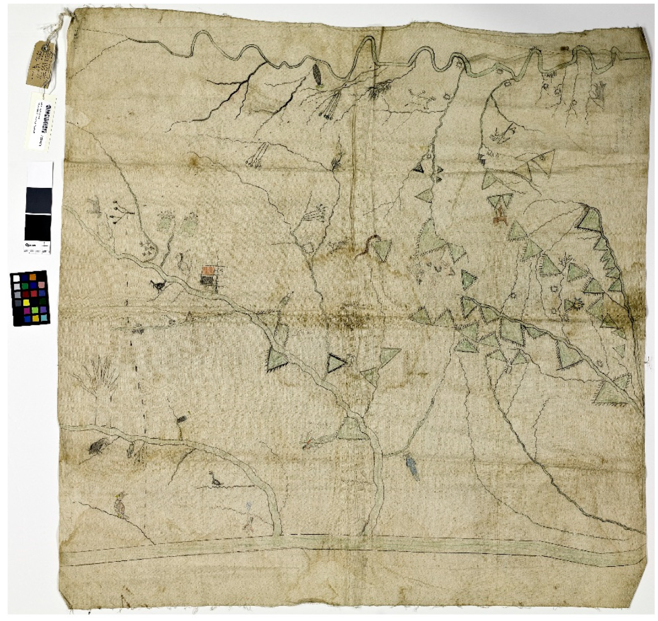
3. Indigitizing a Historical Kiowa Map
The paragraphs below describe several different ways the Chál-k
o-gái map (
Figure 1) informed undergraduate students and was used as a spatial surface for analysis and asking questions. Classroom indigitization creates an origin story of transformation and cross-cultural dialogues. The method, here, is inquiry based and student driven. As students continued to engage with the Kiowa map, more ideas emerged and new approaches to understanding the world influenced students’ thinking as they pondered geographies, both historical and contemporary. The Kiowa map is currently applied to upper-division GIS and human geography courses at the University of Missouri. It is in this place that canvas, paper, pencils, pixels, software, hardware, art, science, and human skills intermingle.
Indigenous maps communicate geographic information differently than scientific maps. One remarkable feature of the map is that it contains what are known as name glyphs [
17] or pictographic/pictorial images. Kiowa pictographic images are associated with their calendar system and ledger art. Kiowa pictorial images hold information about geography and seasonality. Kiowa calendars marked significant summer and winter events using pictorial images that held information about the Kiowas. James Mooney documented a Kiowa calendar and its corresponding information during the 1890s [
18]. More recently, Smithsonian Anthropologist Candace Greene recorded and studied the Silver Horn calendar [
34,
35]. The pictorials complimented Kiowa oral traditions, representing history and geography for the tribe [
35]. Other plains tribes kept similar calendar records. Greene explained that it is likely that the Kiowas adopted the calendars through encounters and exchanges with other plains tribes such as Lakota, Blackfoot, Mandan, Hidatsa, Cheyenne, and Plains Apaches. This is not surprising considering the Kiowa were a migratory group and encountered and exchanged with others along their long journey from the Yellowstone River to southwestern Oklahoma. Presently, the Chál-k
o-gái map is held in the archives at the Museum of Natural History in Washington, DC. Until very recently, the map was only represented in its original canvas form, accessible only to scholars who had permission to view and research the item.
The first author of this paper encountered the digitized Chál-ko-gái map through a series of intended and unintended exchanges with colleagues. He first heard of the Kiowa map in 2007 and the map’s possible temporary residence at the Fort Sill Museum outside of Lawton, OK. Initial phone calls to the museum revealed that the map came and went, and the museum director was unsure of its whereabouts. Only later it was discovered as Meadows was researching the map. Apparently, staff at the Smithsonian had digitized the map, presumably for Meadows so he could research off-site. The first author secured a very low-resolution black and white copy of the map. He used the map to discuss Kiowa representations and geographies at a conference in Hamilton, New Zealand. A Smithsonian geographer and cartographer attending the presentation was surprised at the low quality of the map. In so many words, “a Kiowa geographer should have access to a higher resolution copy of the map”. The Smithsonian cartographer approached the first author and revealed that a high-resolution digital copy of the map existed on his computer in Washington, DC. He offered to send a copy of the map. It traveled through email and now exists as a 79 megabyte image on a computer at the University of Missouri in Columbia.
Making connections with the Smithsonian cartographer and the digitized map was simply an act of luck. Indigenous scholars and community members should not anticipate that other scholars or archivists will share their materials. Of course, this has always been a problem in Indian Country, and it is one of the primary reasons for distrust and lack of support for academic research in communities. Native community members who are interested in historical maps will most likely have to dig through archives and make many phone calls/emails. Digitization of historical maps by archivists is a good start regarding increased mobility and opens up the potential for innovation in education or community projects. Digital computers are rich environments for innovation and converging virtual ideas. Combing two different systems or materials often leads to the creation of a new third thing.
Historical maps exist within transforming social contexts. Originally, the canvas Chál-k
o-gái map informed late 19th century readers (government officials, attorneys, rail companies, settlers) on the location of Kiowa land [
16]. As the University of Missouri geography students found out, these dates are important because they represent a period of land dispossession or the transition from a continuous reservation to individually owned land allotments among the Kiowa, Comanche, and Apache peoples. Chál-k
o-gái used available technologies to create the map including canvas, pencils, and Kiowa calendar images. Mixing these systems created a unique map. Antiquated canvas material had limited mobility. It could be carried by hand or perhaps mailed to distant locations. However, the speed at which canvas material traveled was slow, and archival bureaucracy further limited mobility and access. Furthermore, it is assumed that in the past only a limited number of people had access to the map, much less understood the pictorial content. One hundred years later, the canvas map encountered digital scanners, computer hardware, and software. The map was transformed into a digital construct. Digital constructs flow more freely through fiber-optic lines or from digital cloud to cloud. Mobility was increased and more eyes and ideas made contact with the historical map.
When the first author received a copy of the digital map, it was transformed into a geography-teaching tool. The 79 megabyte image sprang to life, revealing a palate of 256 potential block colors (
Figure 2). The first author is a Kiowa man who currently lives approximately 10 miles east of the Missouri River in Columbia. He is a college professor at the University of Missouri (MU) and teaches several courses on Indigenous geographies, GIS, and mapping. In addition to being a global researcher, he teaches a diverse group of students at the university. The original use of the map, land dispossession through allotment, came and went. Those days are long gone. What remains is a digital map with extremely important geographic information pertaining to Kiowa geography, pictorials, and stories. He combined his knowledge of Kiowa stories, language, art, kinship relations, and lived experience within the mapped region to teach undergraduate students geographic concepts and introduce them to the language of maps. None of the students are Kiowa; they have no kinship relations. However, they are intellectually curious and eager to interpret what they see on the old map. What occurred was a hybridization of the map and its geographic information that Chál-k
o-gái and other Kiowa ancestors never imagined would occur. This kind of system mixing is occurring at other places like the University of Oklahoma, where native languages are taught, yet most students enrolled are not native. This means that non-native students who take the native language sequence (three or four Cherokee, Kiowa, and Choctaw courses) potentially know more about the language than many of the students’ native counterparts living square within their own communities. This real contradiction exists and leads to important questions. Should we put native languages and stories into practice, no matter the context? At least the culture is sustained whether one agrees or not. Arguing strongly against this position at least keeps the ideas alive and shows that people still care about their culture. How about maps? What is more important, putting the Indigenous maps into practice or storing the items away as an old artifact?
At the University of Missouri, Department of Geography, the Chál-ko-gái map melded with a couple of different Western approaches used to explore and understand geography. The first Western system was cartography and GIS. GIS can represent (with or without maps) features on the landscape and are powerful tools for analyzing spatial relationships. The second approach is associated with cultural geography and the naming of places. Historical place names can tell us much about former environmental conditions, social contexts, and landforms. Both of these traditional geography subtopics or systems transform knowledge and information. The map’s unique information, design, space, and place can transform the way people understand the world as well. In fact, the Chál-ko-gái map does not integrate perfectly with either system, requiring some level of adjustment and rethinking on the part of the instructor, reader, or map designer. For instance, undergraduate students are unfamiliar with the meaning of pictorial images. These features must be studied and interpreted using the knowledge at hand. However, students soon learn that the colorful pictures are associated with place names and stories about Kiowa geography. Likewise, the map is an uneasy fit using GIS. The map projection systems that are the foundation of GIS are not compatible with the projection system created by Chál-ko-gái. On the other hand, the place name information can be turned into attribute data and the historical features can be digitized as a vector model. There is much to think about.
Bridging two systems revealed information about projections and coordinate systems that students were unaware of before encountering the digital Chál-ko-gái map. Late nineteenth century surveyors and cartographers created gridded spaces to map out the southern Plains. They only mapped what was inside the grid, nothing more. If territory existed outside the grid, it was mapped on another page or an inset might have been placed somewhere on the map. Black Goose broke these rules. As a map drawn on canvas, the Chál-ko-gái map is not projected using a mathematically shaped coordinate system. Yet, the space that makes up what is now southwest Oklahoma and northwest Texas is presented. The entire area is important when trying to understand the territorial extent of the tribe. However, there was not enough room to draw important aspects of the Washita River that extends to the northwest and into the Texas Panhandle. As a result, Chál-ko-gái manipulated and bent space. What an interesting problem for GIS students. Non-experts can create their own projection systems?
The digitized Chál-ko-gái map is a gateway into the theories and ideas of critical GIS. As Crampton and Krygier (2006) stated about Indigenous maps:
“These map events question the commensurability of Euclidean space, a basic assumption of much GIS. Euclidean space is a key component of the scientization and regularization of space, for example it is assumed in ‘interoperability’ where one dataset is commensurable with another. Critiques of Euclidean space which point to its idiosyncrasies, localness or its contingent nature show that not all knowledge can be ‘scientized’.”
The challenge for GIS students is to determine what kinds of information on the map can be used to create a database or analyzed using computers. The indigenity of the mapped information and the intellectual challenges posed by Indigenous perspectives is what makes the map construct indigital.
The digital copy of the map shows rivers, creeks, mountains, land parcels, and vegetation. Students zoomed in and out while analyzing the dendritic stream patterns and studied how they grip and hold the mapped space together. Meadows [
17] inventoried hundreds of Kiowa place names. Nearly 80% of the names are associated with rivers, creeks, and springs. Technically oriented GIS students can easily cut place names found in e-copies of Meadow’s book and paste them into a GIS database. Adding the Kiowa names to a GIS database and labeling features in Kiowa on a map is a form of indigitization.
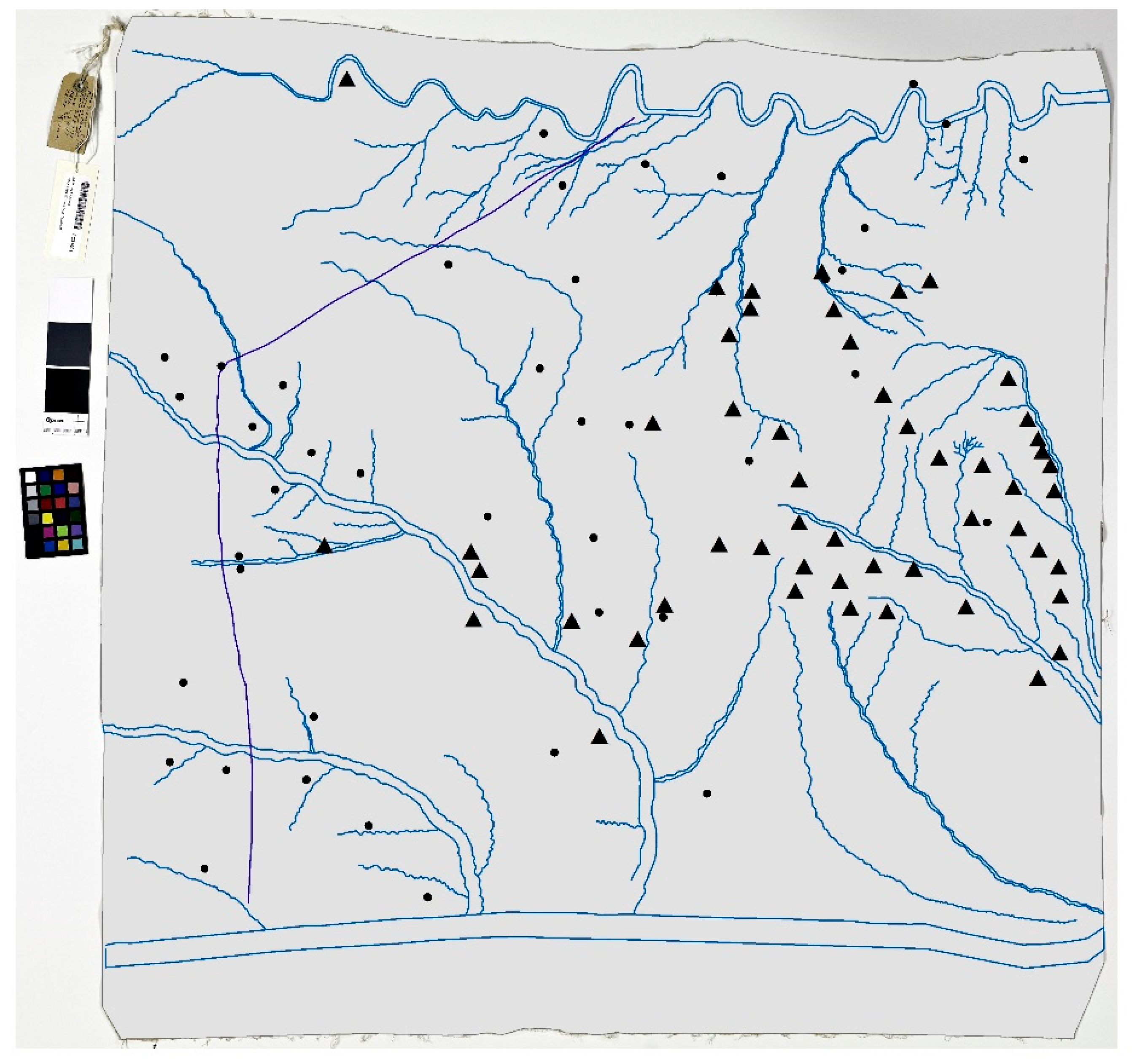
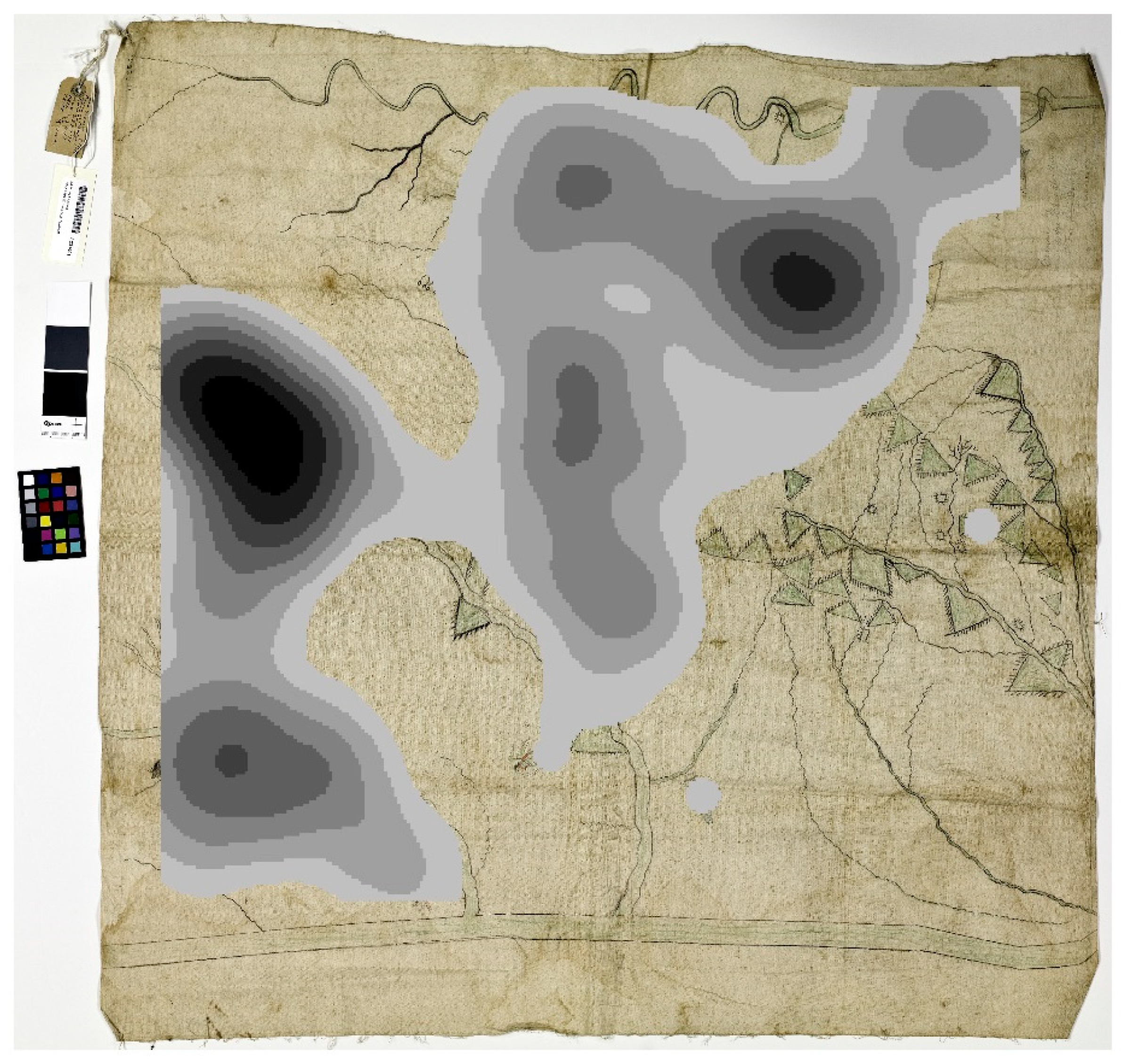
Figure 3 shows the work of a graduate student who digitized the features on the map. The rivers and streams are digitized exactly as they appear on the map, but other features, such as maps and the pictographs, are digitized as points (
Figure 3). What is the point? By converting the map features to points, students can analyze the density of the features to determine where, on the KCA, Chál-k
o-gái placed most of his attention. A cross-cultural dialogue emerges (
Figure 4). Why are rivers and creeks so important to Kiowas? Did Chál-k
o-gái have more knowledge about places containing a higher density of name glyphs? Did Chál-k
o-gái come from a politically influential family? Are the name-glyphs associated with kinship relations or family stories? Why are women’s views not recorded on the map?
Cultural geography students study the language of maps. The indigital map prompts students to ask questions about semiotics or the language of the map. Symbols on a map can refer to one thing or many things. Students read topographic maps and the meaning is often abstract, presenting contour lines or blue meandering lines that they presume represent rivers. Previous students asked, are there other ways of representing features on maps? The Chál-ko-gái map is different in that not only are symbols present for physical features but also attached to those physical features are pictorial images that are associated with stories and information. Triangular mountains are smeared across the map. Some mountains are small while others are larger. On purpose or inadvertently, Chál-ko-gái developed a visual classification of the mountains or a local ontology. Those with lines or trees are associated with the granite Wichita Mountains. Other mountains to the north are smooth and represent the limestone Slick Hills. On Chál-ko-gái’s map specifically, the mountain icons are represented visually as green triangles, some crowned with vertical lines and some without lines. These vertical lines represent the blackjack oak vegetation type that grows almost exclusively on and at the base of the granite Wichita Mountain formations in the area. Similar to the projection system, Chál-ko-gái created a personal ontology or way of representing mountains on his map (granite vs limestone).
On the map, typical linguistic information is absent, aside from an outlier group of written place names and one cartographic credit. Kiowa language codes, however, are abundant. Instead of being extracted from and layered atop the map’s features, they remain embedded within the pictorials and, as such, become part of the landscape itself, rather than descriptors for it. Consider the pictorial of a prairie dog near the Washita River. The drawing functions as both an iconic symbol, signifying a feature on the landscape and as a linguistic label, denoting the name of the location: Prairie-Dog-Eating-Creek. But, critically, it also functions as a mnemonic device: as we process what we are looking at, the symbol invokes the name, which, happening in the present (Prairie-Dog-Eating), invokes the story of how the name came about. For the Kiowas, it is a story of survival. The name and the experience cannot occur separately. In the map, pictorials prompt viewers to ask not only “what is there?” but “what has happened there?”. Chál-k
o-gái drew attention to the sprawling, widespread nature of the KCA landscape. There is so much there, it takes up the entire map space, extending to all corners, and yet still goes on—he even had to bend space to fit some of it on the map. The Chál-k
o-gái map argues that no map can fully represent his landscape. Western overtones of cartographic license are not present. Rather, by showing a portion of the landscape, he attests to its immensity and to its entirety, “creating a sense of geographical meaning” [
36] (p. 17). Chál-k
o-gái firmly established the map showing Kiowa land. In exploring these topics, students soon learn that maps are political.
Is the Chál-k
o-gái map an early form of counter-mapping? Of course, the term counter-mapping did not emerge until the mid-1990s. Nancy Peluso defined counter-mapping as an alternative strategy for defending territorial and/or resource claims [
37]. Counter-mapping is an important concept regarding Indigenous geographies and cartographies on a global scale. The concept gained traction early on as a way of countering the impacts of economic globalization. How long have Indigenous peoples used maps to counter colonial and imperialistic narratives? University of Missouri students were introduced to the idea that the Chál-k
o-gái map exists within the spirit of counter-mapping and just might be one of the earliest examples of a Plains Indian counter-map. The relatedness associated with land dispossession, resource grabs, and Indigenous removals is an eye-opening example that the tyrannies of capitalism, today, are not new. Seasoned scholars are well aware of this condition. However, the indigital map introduced this, in tangible form, to students, who now view the map as having something important to say within intense conversations on economic globalization. Nevertheless, theoretical perspectives and methods associated with decolonial geographies would further inform students and strengthen future work on indigital constructs.
4. Conclusions
Indigenous knowledge and representations are emerging in academic research and classroom teaching. Vine Deloria, Jr. envisioned this happening among academics and students at colleges and universities. Increasingly, there is evidence that Indigenous perspectives are making their way into university classrooms and academic research methods. Referred journals are paying attention and publishing research on Indigenous philosophies, methodologies, and geographies. Funding agencies are taking note and funding projects that bridge Indigenous and Western knowledge systems. The United Nations is attempting to bridge Indigenous and Western knowledge systems. More and more written forms of Indigenous languages are being developed in North America. Perhaps the most important first step in relating ideas is asking questions. Good questions are the foundation of research designs, research proposals, and class discussions. Questioning is the initial step enabling students and scholars to begin uncovering the reasons why Indigenous and Western philosophies have come to be separated in the first place. In fact, there should be multiple ways to go about bridging Indigenous and Western ideas. Similarities and differences between philosophies, ideas, concepts, theories, and practices can become bridges. In our minds, we can use bridges to walk freely between what some scholars deem purely Indigenous or purely Western. For students and scholars, bridging can be a liberating, decolonizing process leading to new ways of thinking about the Earth.
In our account, we showed that the Chál-ko-gái map is an amalgamation of sketching, artistry, land tenure, salvage anthropology, national museums, large scanners, computers, software, email, classrooms, and communities. One system does not dominate the others and there is no one-way flow of information. As soon as the students, cultural geography or GIS, think they have answers provided by their academic frameworks, the pictorial images and embedded stories take back the power and make the map rigorous to understand and use. A reciprocal give and take emerges, where students and the maps talk with each other, not at each other. Reciprocal theories or applications can eventually open up dialogues with native communities and help shape learning opportunities in both the academy and community. The process may happen quickly, it may be a slow process, or the process of dialogue may never arise. This is because the theories, applications, materials, hardware, software, skills, and motivations have to contend with a still present digital divide or other human constructed divides.
Future research should focus on the process of bridging Indigenous and Western knowledge systems. It is within processes that opportunities emerge, whether in the classroom, laboratory, or community. How successful has the blending of knowledge systems become over the past 20 or so years? What are other examples of bridging projects in North America and globally? What does culturally appropriate technology mean within the context of the knowledge and information economy? Many similar questions can help shed light on the next cycle of Indigenous thought.

