QRB-tree Indexing: Optimized Spatial Index Expanding upon the QR-tree Index
Abstract
1. Introduction
2. QRB-tree Index
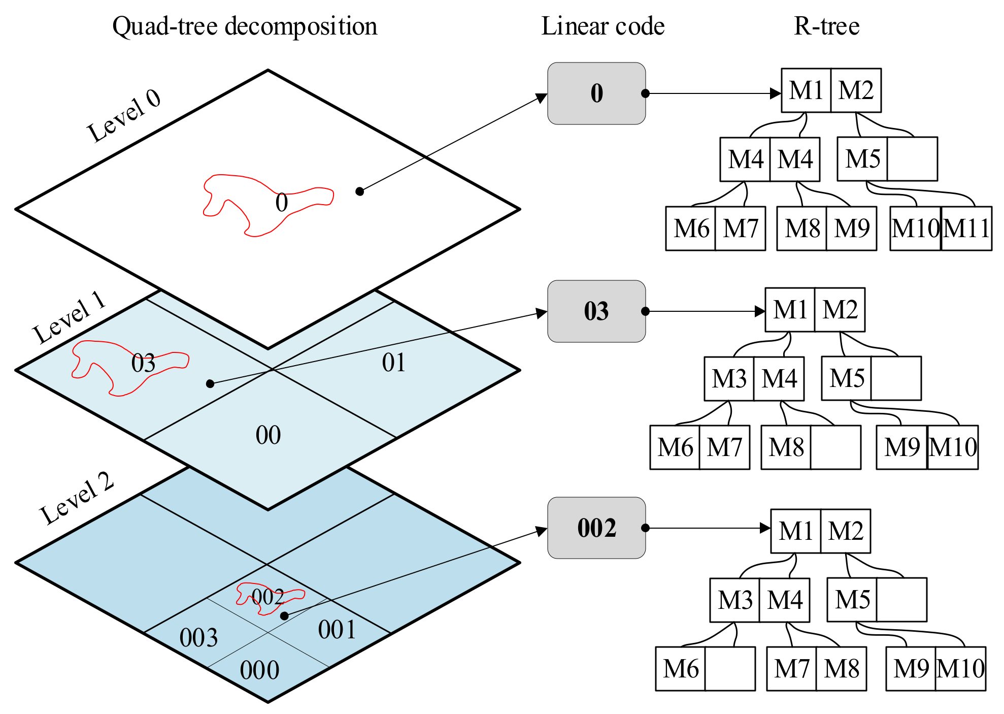
- Grid decomposition: decompose the region into multi-level grids with a quad-tree and compute thee linear codes;
- R-tree location: locate the index files of the associated R-trees for the grids from the disk with their linear codes;
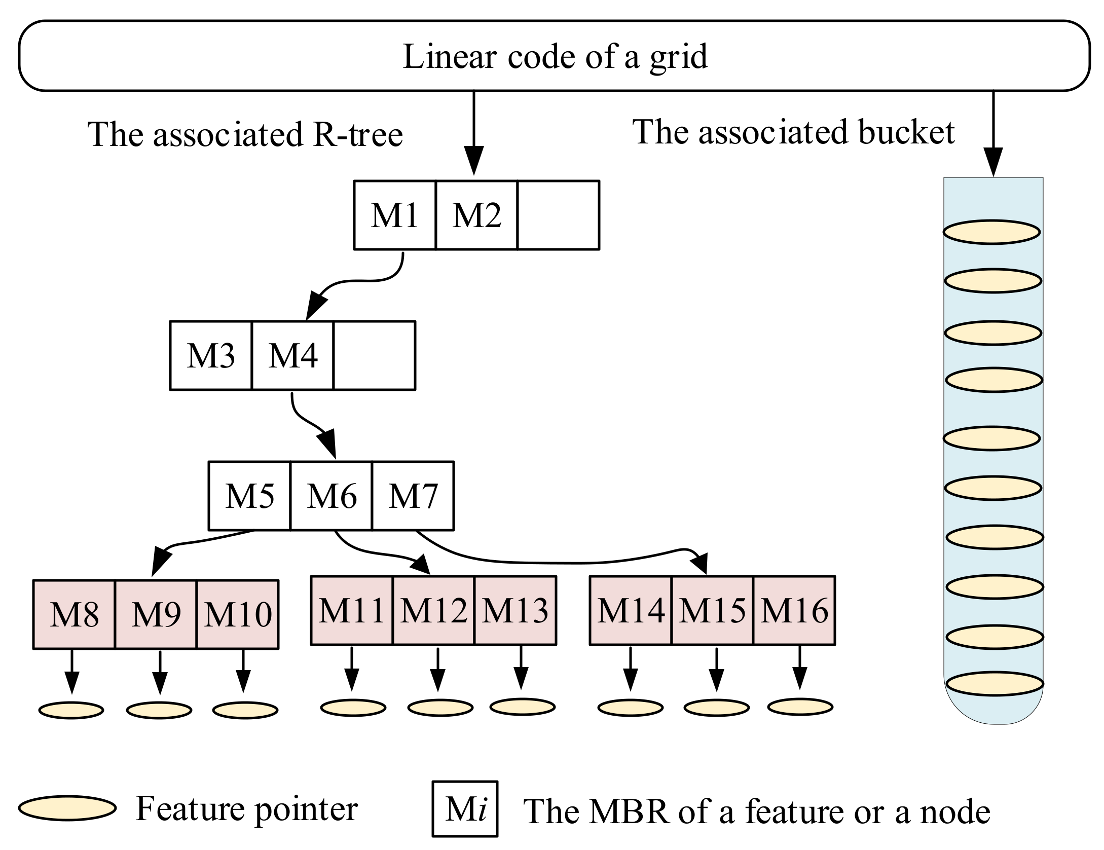
- R-tree loading: load the index files from the disk and build memory R-trees;
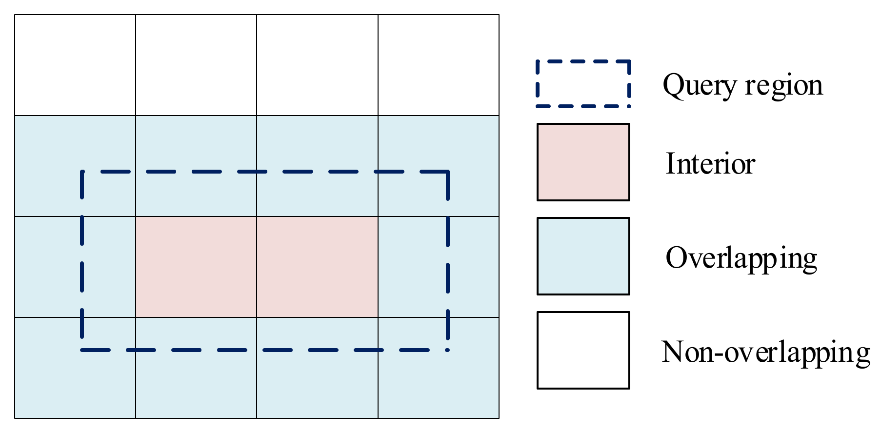
- R-tree search: search each of the memory R-trees by the region in the memory to retrieve candidate features;
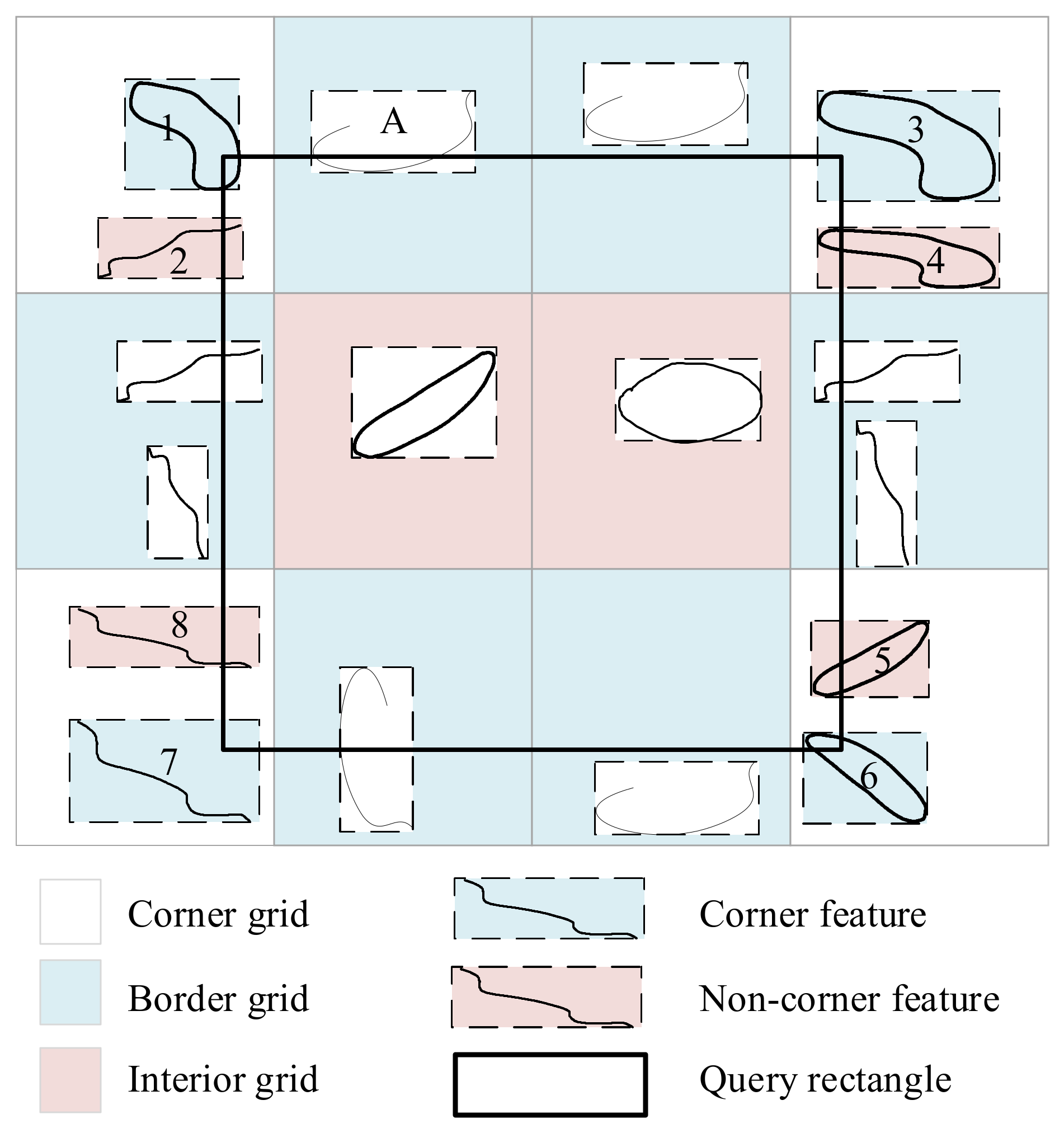
- Feature elimination: eliminate the candidate features that do not intersect with the region.
2.1. Optimizations of the R-tree Loading and Search Steps
| Algorithm 1 RLoad () |
BEGIN
|
2.2. Optimization of the Feature Elimination Step
2.3. Insert Algorithm
| Algorithm 2 Insert |
| INPUT: ptr, pointer of the feature to be inserted MBR, minimum bounding rectangle of the feature to be inserted L0, maximal grid level BEGIN
|
2.4. Search Algorithm
| Algorithm 3 Rough search |
| INPUT: rect, rectangle for query L0, maximal grid level OUTPUT: ftrs, features retrieved by the algorithm BEGIN
|
| Algorithm 4 Exact search |
| INPUT: rect, rectangle for query L0, maximal grid level OUTPUT: ftrs, features retrieved by the algorithm BEGIN
|
3. Choice of Maximal Grid Level ()
3.1. Impact of on the Performance
3.2. Determination of
3.3. Determination of
4. Tests and Comparisons
5. Conclusions
Author Contributions
Funding
Data Availability Statement
Acknowledgments
Conflicts of Interest
References
- Yao, X.; Li, G. Big spatial vector data management: A review. Big Earth Data 2018, 2, 108–129. [Google Scholar] [CrossRef]
- Guo, H.; Liu, Z.; Jiang, H.; Wang, C.; Liu, J.; Liang, D. Big Earth Data: A new challenge and opportunity for Digital Earth’s development. Int. J. Digit. Earth 2016, 10, 1–12. [Google Scholar] [CrossRef]
- OGC. OpenGIS® Implementation Standard for Geographic information—Simple Feature Accessx–Part 1: Common Architecture; OGC 06-103r4; Open Geospatial Consortium: Rockville, MD, USA, 2011. [Google Scholar]
- Mamoulis, N. Spatial Data Management. In Synthesis. Lectures on. Data Management; Morgan & Claypool: San Rafael, CA, USA, 2011; Volume 3, pp. 1–149. [Google Scholar] [CrossRef]
- Kothuri, R.K.; Ravada, S. Efficient Processing of Large Spatial Queries Using Interior Approximations. In Proceedings of the 7th International Symposium, SSTD 2001, Redondo Beach, CA, USA, 12–15 July 2001; Advances in Spatial and Temporal Databases. pp. 404–421. [Google Scholar] [CrossRef]
- Park, H.-H.; Cho, H.-J.; Chung, C.-W. Heuristic approach for early separated filter and refinement strategy in spatial query optimization. J. Syst. Softw. 2002, 62, 161–179. [Google Scholar] [CrossRef]
- Kothuri, R.K.V.; Ravada, S.; Abugov, D. Quadtree and R-tree indexes in oracle spatial: A comparision using GIS data. In Proceedings of the ACM SIGMOD International Conference on Management of Data, Madison, WI, USA, 4–6 June 2002; pp. 546–557. [Google Scholar] [CrossRef]
- Nievergelt, J.; Hinterberger, H.; Sevcik, K.C. The Grid File: An Adaptable, Symmetric Multikey File Structure. ACM Trans. Database Syst. 1984, 9, 38–71. [Google Scholar] [CrossRef]
- Finkel, R.A.; Bentley, J.L. Quad trees a data structure for retrieval on composite keys. Acta Inform. 1974, 4, 1–9. [Google Scholar] [CrossRef]
- Bartholdi, J.J.; Goldsman, P. Continuous indexing of hierarchical subdivisions of the globe. Int. J. Geogr. Inf. Sci. 2001, 15, 489–522. [Google Scholar] [CrossRef]
- Ottoson, P.; Hauska, H. Ellipsoidal quadtrees for indexing of global geographical data. Int. J. Geogr. Inf. Sci. 2002, 16, 213–226. [Google Scholar] [CrossRef]
- Cho, W.; Choi, E. A basis of spatial big data analysis with map-matching system. Clust. Comput. 2017, 20, 2177–2192. [Google Scholar] [CrossRef]
- Sakr, M. A data model and algorithms for a spatial data marketplace. Int. J. Geogr. Inf. Sci. 2018, 32, 2140–2168. [Google Scholar] [CrossRef]
- Lei, Y.; Tong, X.; Zhang, Y.; Qiu, C.; Wu, X.; Lai, G.; Li, H.; Guo, C.; Zhang, Y. Global multi-scale grid integer coding and spatial indexing: A novel approach for big earth observation data. ISPRS J. Photogramm. Remote. Sens. 2020, 163, 202–213. [Google Scholar] [CrossRef]
- Guttman, A. R-trees: A dynamic index structure for spatial searching. In Proceedings of the ACM management of data (SIGMOD), Boston, MA, USA, 18–21 June 1984; pp. 47–57. [Google Scholar]
- Sellis, T.; Roussopoulos, N.; Faloutsos, C. The R+-Tree: A Dynamic Index for Multi-Dimensional Objects. In Proceedings of the Thirteenth International Conference on Very Large Data Bases: 1987, 13th VLDB, Brighton, UK, 1–4 September 1987; pp. 507–518. [Google Scholar] [CrossRef]
- Beckmann, N.; Kriegel, H.-P.; Schneider, R.; Seeger, B. The R*-tree: An efficient and robust access method for points and rectangles. ACM SIGMOD Rec. 1990, 19, 322–331. [Google Scholar] [CrossRef]
- Kamel, I.; Faloutsos, C. Hilbert R-tree: An improved R-tree using fractals. In Proceedings of the 20th International Conference on Very Large Databases, Santiago, Chile, 12–15 September 1993; pp. 500–509. [Google Scholar]
- Arge, L.; De Berg, M.M.; Haverkort, H.H.; Yi, K. The priority R-tree: A Practically Efficient and Worst-Case Optimal. R-tree. ACM Trans. Algorithms 2008, 4, 1–30. [Google Scholar] [CrossRef]
- Silva, Y.N.; Xiong, X.; Aref, W.G. The RUM-tree: Supporting frequent updates in R-trees using memos. VLDB J. 2009, 18, 719–738. [Google Scholar] [CrossRef]
- Yang, Y.; Bai, P.; Ge, N.; Gao, Z.; Qiu, X. LAZY R-tree: The R-tree with lazy splitting algorithm. J. Inf. Sci. 2019, 46, 243–257. [Google Scholar] [CrossRef]
- Singh, H.; Bawa, S. A Survey of Traditional and MapReduce-Based Spatial Query Processing Approaches. SIGMOD Rec. 2017, 46, 18–29. [Google Scholar] [CrossRef]
- Goyal, P.; Challa, J.S.; Kumar, D.; Bhat, A.; Balasubramaniam, S.; Goyal, N. Grid-R-tree: A data structure for efficient neighborhood and nearest neighbor queries in data mining. Int. J. Data Sci. Anal. 2020, 10, 25–47. [Google Scholar] [CrossRef]
- Lee, K.Y.; Kang, J.J.; Kim, J.J.; Choi, G.S.; Lee, Y.D.; Cho, S.Y.; Oh, S.J. Indexing method for moving sensor node retrieval. Int. J. Sens. Netw. 2014, 15, 238–245. [Google Scholar] [CrossRef]
- Fu, Y.-C.; Hu, Z.-Y.; Guo, W.; Zhou, D.-R. QR-tree: A hybrid spatial index structure. In Proceedings of the 2003 International Conference on Machine Learning and Cybernetics (IEEE Cat. No.03EX693), Xi’an, China, 5 November 2003. [Google Scholar] [CrossRef]
- Huang, B.; Wu, Q. A Spatial Indexing Approach for High Performance Location Based Services. J. Navig. 2007, 60, 83–93. [Google Scholar] [CrossRef]
- Wang, Y.; Zhu, Y.; Sun, H. Study of Spatial Data Index Structure Based on Hybrid Tree. In Knowledge Engineering and Management; Springer: Berlin/Heidelberg, Germany, 2011; Volume 123, pp. 559–565. [Google Scholar] [CrossRef]
- Yang, Z.X.; Hao, Z.X. Spatial Join Queries Based on QR-tree. Adv. Mater. Res. 2011, 187, 752–757. [Google Scholar] [CrossRef]
- Mao, H.; Bian, F. Design and Implementation of QR+Tree Index Algorithms. In Proceedings of the 2007 International Conference on Wireless Communications, Networking and Mobile Computing, Shanghai, China, 21–25 September 2007; pp. 5987–5990. [Google Scholar] [CrossRef]
- Phan, T.K.; Jung, H.; Youn, H.Y.; Kim, U.M. QR*-Tree: An Adaptive Space-Partitioning Index for Monitoring Moving Objects. J. Inf. Sci. Eng. 2017, 33, 385–411. [Google Scholar] [CrossRef]
- Guo, J.; Guo, W.; Zhou, D. Indexing of Constrained Moving Objects for Current and Near Future Positions in GIS. In Proceedings of the First International Multi-Symposiums on Computer and Computational Sciences (IMSCCS’06), Hangzhou, China, 20–24 June 2006. [Google Scholar] [CrossRef]
- Hjaltason, G.R.; Samet, H. Speeding up construction of PMR quadtree-based spatial indexes. VLDB J. 2002, 11, 109–137. [Google Scholar] [CrossRef]
- Hohl, A.; Casas, I.; Delmelle, E.; Tang, W. Hybrid Indexing for Parallel Analysis of Spatiotemporal Point Patterns. In Proceedings of the 9th International Conference on Geographic information Science, Montreal, QC, Canada, 27–30 September 2016. [Google Scholar] [CrossRef]
- Yang, J.; Huang, X. A Hybrid Spatial Index for Massive Point Cloud Data Management and Visualization. Trans. GIS 2014, 18, 97–108. [Google Scholar] [CrossRef]
- Gu, W.; Wang, J.; Shi, H.; Liu, Y. Research on a hybrid spatial index structure. J. Colloid Interface Sci. 2011, 11, 3972–3978. [Google Scholar]
- Wang, Y.; Lv, H.; Ma, Y. Geological tetrahedral model-oriented hybrid spatial indexing structure based on Octree and 3D R*-tree. Arab. J. Geosci. 2020, 13, 728. [Google Scholar] [CrossRef]
- Du Mouza, C.; Litwin, W.; Rigaux, P. SD-Rtree: A Scalable Distributed Rtree. In Proceedings of the 2007 IEEE 23rd International Conference on Data Engineering, Istanbul, Turkey, 15–20 April 2007; pp. 296–305. [Google Scholar] [CrossRef]
- Malensek, M.; Pallickara, S.; Pallickara, S. Evaluating Geospatial Geometry and Proximity Queries Using Distributed Hash Tables. Comput. Sci. Eng. 2014, 16, 53–61. [Google Scholar] [CrossRef]
- Elashry, A.; Shehab, A.; Riad, A.M.; Aboul-Fotouh, A. 2DPR-tree: Two-Dimensional Priority R-tree Algorithm for Spatial Partitioning in SpatialHadoop. ISPRS Int. J. Geo-Inf. 2018, 7, 179. [Google Scholar] [CrossRef]
- Xia, J.; Huang, S.; Zhang, S.; Li, X.; Lyu, J.; Xiu, W.; Tu, W. DAPR-tree: A distributed spatial data indexing scheme with data access patterns to support Digital Earth initiatives. Int. J. Digit. Earth 2020, 13, 1656–1671. [Google Scholar] [CrossRef]
- Han, D.; Stroulia, E. HGrid: A Data Model for Large Geospatial Data Sets in HBase. In Proceedings of the 2013 IEEE Sixth International Conference on Cloud Computing, Santa Clara, CA, USA, 28 June–3 July 2013; pp. 910–917. [Google Scholar] [CrossRef]
- Park, S.-Y.; Bae, H.-Y. A Distributed Spatial Index for Time-Efficient Aggregation Query Processing in Sensor Networks. In Proceedings of the Computational Science—ICCS, Singapore, 9–12 May 2005; pp. 405–410. [Google Scholar] [CrossRef]
- Bianchi, S.; Felber, P.; Potop-Butucaru, M.G. Stabilizing Distributed R-trees for Peer-to-Peer Content Routing. IEEE Trans. Parallel Distrib. Syst. 2010, 21, 1175–1187. [Google Scholar] [CrossRef]
- Feng, J.; Ren, F.; Tang, Z. Hadoop-based QR-tree index. Comput. Eng. Des. 2013, 12, 4231–4236. [Google Scholar] [CrossRef]
- Singh, H.; Bawa, S. An improved integrated Grid and MapReduce-Hadoop architecture for spatial data: Hilbert TGS R-tree-based IGSIM. Concurr. Comput. Pract. Exp. 2019, 31, e5202. [Google Scholar] [CrossRef]
- Morton, G.M. A computer oriented geodetic data base and a new technique in file sequencing. IBM Ger. Sci. Symp. Ser. 1966, 294–897. [Google Scholar]
- Huffman, C. Storage; Syngress: Rockland, MA, USA, 2015. [Google Scholar]
- Varalakshmi, M.; Kesarkar, A.P.; Lopez, D. High-performance implementation of a two-bit geohash coding technique for nearest neighbor search. Concurr. Comput. Pract. Exp. 2020, 33, e6029. [Google Scholar] [CrossRef]

Publisher’s Note: MDPI stays neutral with regard to jurisdictional claims in published maps and institutional affiliations. |
© 2021 by the authors. Licensee MDPI, Basel, Switzerland. This article is an open access article distributed under the terms and conditions of the Creative Commons Attribution (CC BY) license (https://creativecommons.org/licenses/by/4.0/).
Share and Cite
Yu, J.; Wei, Y.; Chu, Q.; Wu, L. QRB-tree Indexing: Optimized Spatial Index Expanding upon the QR-tree Index. ISPRS Int. J. Geo-Inf. 2021, 10, 727. https://doi.org/10.3390/ijgi10110727
Yu J, Wei Y, Chu Q, Wu L. QRB-tree Indexing: Optimized Spatial Index Expanding upon the QR-tree Index. ISPRS International Journal of Geo-Information. 2021; 10(11):727. https://doi.org/10.3390/ijgi10110727
Chicago/Turabian StyleYu, Jieqing, Yi Wei, Qi Chu, and Lixin Wu. 2021. "QRB-tree Indexing: Optimized Spatial Index Expanding upon the QR-tree Index" ISPRS International Journal of Geo-Information 10, no. 11: 727. https://doi.org/10.3390/ijgi10110727
APA StyleYu, J., Wei, Y., Chu, Q., & Wu, L. (2021). QRB-tree Indexing: Optimized Spatial Index Expanding upon the QR-tree Index. ISPRS International Journal of Geo-Information, 10(11), 727. https://doi.org/10.3390/ijgi10110727


